The Playhouse (First Theater) Archaeological Report Block 29
Building 17BOriginally entitled: "Archaeological Report Block 29,
Area C, (Northwest Corner of Colonial Lot 164)"
Colonial Williamsburg Foundation Library Research Report
Series - 1588
Colonial Williamsburg Foundation Library
Williamsburg, Virginia
1990
DRAFT
First TheatreARCHAEOLOGICAL REPORT
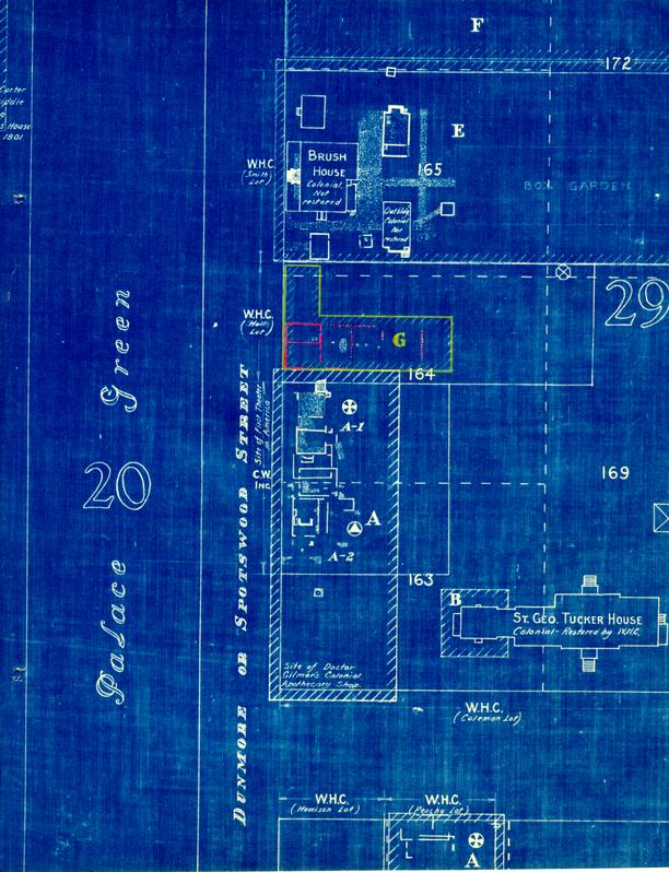
BLOCK 29, AREA G
Bldg. 17A(Northwest Corner of Colonial Lot 164)
This area was excavated during the months of April and May 1947. Although the Frenchman's Map does not show a building on this site, the remains of a colonial brick foundation were located 39' - 0" south of the property formerly owned by Miss Estelle Smith. The front or west side of the foundation sat back approximately 1' - 6" from the east line of Spotswood Street. Its dimensions were 30' - 2 ½" x 22' - 3" with a wall thickness of 13 ½". Running east and west, approximately 2' - 6" north of the center line, was a 9" partition or crosswall. The number of brick courses in this foundation ranged from one to three at various places. There was a slightly different size brick used in the north portion of the foundation from that used in the south portion. The building that once existed on this site never had a basement and may have been constructed of brick. It was probably wrecked or torn down as no evidence of a fire on this site was discovered.
Inside the foundation near the northeast corner was found a rectangular fill, 5' - 0" in depth, which contained only wood ashes. According to the strata of the top soil this was done earlier than the construction of the surrounding foundation walls.
No evidence of a chimney or entrance steps could be found.
| Brick size | - north portion | - 8" x 3-7/8" x 2-¾" |
| Color | - Dark red and brown | |
| Bond | - English | |
| Mortar | - Shell | |
| Brick size | - south portion | - 8-7/8" x 4 ¼" x 2 ½" |
| Color | - Red and buff | |
| Bond | - English | |
| Mortar | - Shell |
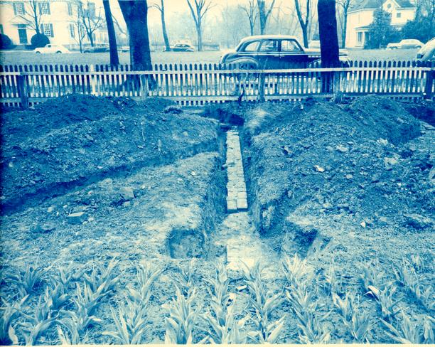
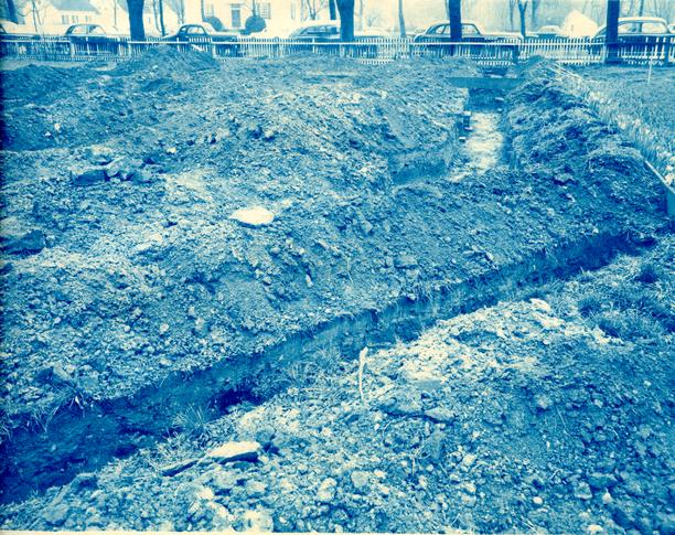
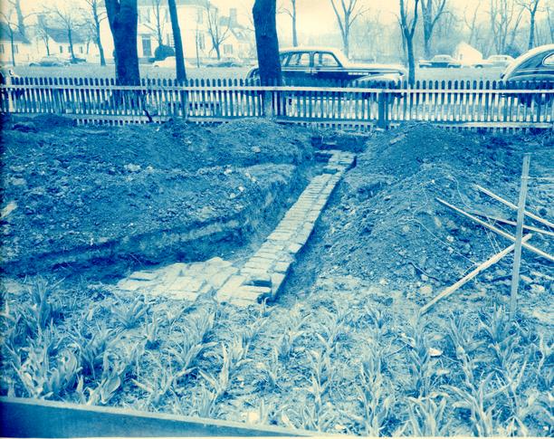
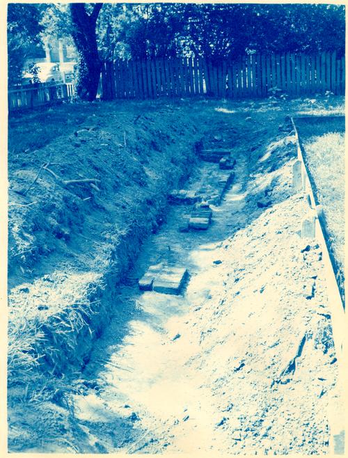
See photographs W116, W117, W118, W119, W120, and W121.
Continued investigation east of the building foundation brought to light
evidence of where brick walls once existed, although no actual foundation wall
was uncovered. The brickwork in this area had undoubtedly
been salvaged, leaving only traces of backfilled trenches.
Running east and on line with the north and south ends of the existing foundation valls were found traces of shell mortar and brick fragments. The longest of these fills extended a distance of 33' - 0" from the foundation wall.
There was evidence of three other walls having existed in this general area. They ran north and south and paralleled the east wall of the existing foundation. The first of these fills of mortar and brick fragments to be exposed was 18' - 0" from the existing east Wall. This was a very definite indication of where a wall had been as it consisted of a level and well-defined layer of fragments. The second evidence of salvaged cross wall was 37' - 6" from the brick foundation and was a strip approximately 7' - 0" in length. Accepting this as the rear of an addition to the existing foundation, it would have been a building with an overall dimension of 60' - 6" a 30' - 2 ½". Farther to the east at a distance of approximately 63' - 0" from the brick foundation were the third fragmentary remains of a cross wall. This extended a distance of approximately 28' - 0", paralleling the other two cross wall fills. If this originally was the rear of an addition or extension to the building that once existed on the brick foundation, it would have 3 been a structure 86' - 6" x 30' - 2 ¼".
The remains of five 9" x 9" holes, one containing the remains of a rotten post, were found within this area. Four of these holes were in line while the other one was approximately 1' - 6" to the north of the line. It may be noted that if the 9" brick cross wall, inside the existing foundation, was extended to the east, these holes would be just to the north and south side of it. A theory is that these holes were the location of post or upright timbers placed there to support the ceiling when it began to sag in the center at some later date. (See archaeological drawing.)
The predominating artifacts found in this area were mostly articles from an apothecary shop, such as pill caps and small medicine bottles - both broken and whole ones. Thirteen feet east of the brick foundation wall, almost on the center line, was a 10' - 0" x 4' - 0" fill of well-packed debris. This was composed of black earth, broken ale bottles, small medicine bottles, pill cups and fragments of eighteenth-century china.
Since the existing foundation appears to be one complete unit with all outside walls bonded together, one final conclusion in regard to this area may be that there once existed on this site during the eighteenth century, a story-and-half brick building facing on Palace Green. On the rear was a long wood addition, the same width as the brick building. It may be said that this foundation is sot heavy enough to support a brick building but at the same time there are several existing brick buildings in Williamsburg with approximately the same wall thickness - such as the Brush Kitchen, Van Garrett Kitchen and Custis Kitchen.
J.M.K.
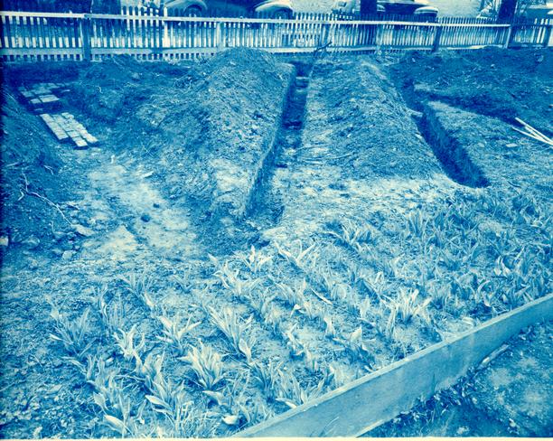 Photograph
W116
Photograph
W116
 Photograph
W117
Photograph
W117
 Photograph
W118
Photograph
W118
 Photograph
W119
Photograph
W119
 Photograph
W120
Photograph
W120
 Photograph
W121
Photograph
W121
Illustration #2
First Theatre Report
 From Frenchman's Map 1782?
Note: Only ¼ of lot #164 has been excavated
PHOTOSTAT COPY OF THE WILLIAMSBURG PLAT IN "WILLIAMSBURG, THE OLD COLONIAL CAPITOL" BY LYON G. TYLER