Robertson's Windmill Archaeological Report, Block 28 Building
24A Originally entitled: "Archaeological Report Block 28,
Area C (Possible Site of Colonial Windmill)"
Colonial Williamsburg Foundation Library Research Report
Series - 1548
Colonial Williamsburg Foundation Library
Williamsburg, Virginia
1990
ARCHAEOLOGICAL REPORT
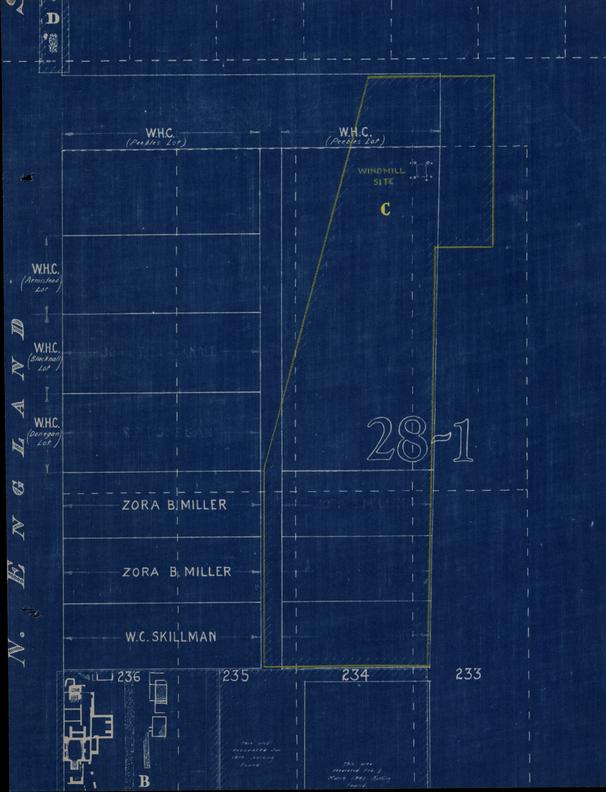
BLOCK 28, AREA C
(Possible Site of Colonial Windmill)
The archaeological excavation in Block 28, Area C, was done during the first and second weeks of April 1940. It covers that area which has recently become known as the north entrance to the "Colonial National Parkway Tunnel," which is to be constructed during 1940-1941.
No foundations or fragments of brick and mortar were found in this area except in the vicinity of the east end of Scotland Street. From the nature of the soil it appears that most of this area was used only for cultivation purposes or probably for pasture land in the past.
Just south of Scotland Street where it intersects Queen Street, according to Bucktrout's Map of Williamsburg, considerable fill was exposed which was composed mostly of broken bricks, fragments of shell mortar and pieces of early plaster. This was carefully excavated and was discovered to be in an 8' - 6" x 6' - 6" rectangular depression, the bottom of which was approximately 2' - 6" below present grade. The floor or bottom of this depression was level and continued down to yellow clay which gives it the appearance of being dug for a definite purpose originally. Continuing the excavation in search of some evidence of old foundation walls, patches of black dirt, one containing rotten wood, appeared near three corners of the large depression. These proved to be originally 12" x 12" square holes dug to a depth of 2' - 6" below the present grade. Five smaller holes, approximately 6" a 6", filled with black dirt, one containing the remains of a cedar post, were found on line and about 3' - 0" from the corners of the 8' - 6" x 6' - 6". (See archaeological drawing).
2Early records, dated December 12, 1723, mention four lots in this vicinity being sold by William Robertson to John Holloway with houses and windmill. It is possible that this is the windmill site and the 12" x 12" holes could have been the location of heavy upright timbers or supports that served as a wood foundation for a structure, since no evidences of brick foundation walls were found. It is logical that on account of a practically continuous vibration, a structure such as a windmill would need a rather heavy foundation, and, if such had existed, the chances are that some evidence would have been discovered. The 6" x 6" holes may have been the location of timbers used to brace the heavier upright supports. Another theory is that they once held posts supporting a circular track on which the tower portion of the windmill revolved.
This site appears to be a good location for a windmill from the standpoint of being on high ground overlooking a rather large ravine to the north and east. Also there is no evidence of any other structure being nearby which would obstruct the prevailing southwest summer winds.
Just to the east and northeast of this site in what was at one time the intersection of Queen and Scotland Streets, according to Bucktrout and the Unknown Draftsman's Maps, were found patches of fill containing old brick bats and fragments of shell mortar. The general appearance is that it was dumped there to fill up small holes that were made during the period when this was used as a traveled way. Along the east side of Queen Street, at this point, is the crest of a very steep hill which makes it possible that much of this fill may also have been placed there to prevent erosion.
Colonial Williamsburg
Architectural Department
May 11, 1940
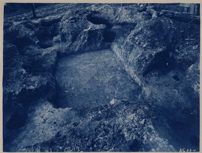 Photograph N 6337