Peyton Randolph House Archaeological Report, Block 28 Building 6 Lot 236Originally entitled: "Peyton Randolph House Interim Notes"
Colonial Williamsburg Foundation Library Research Report Series - 1540
Colonial Williamsburg Foundation Library
Williamsburg, Virginia
1990
PEYTON RANDOLPH HOUSE
1978
INTERIM NOTES
INTRODUCTION
From January 13 to March 22, the Department of Archaeology conducted excavations at the Peyton Randolph House, Lot 28, Area G, as part of a long term project to investigate and restore the outbuildings and gardens on the property. The work was supervised by William Henry and was restricted to the remains of an outbuilding located at the northwest corner of the property. Only a temporary grid was established for the area as assistance from the C.W. surveyors was unavailable.
Excavations carried out by archaeologist James A. Knight in 1955 had located the foundation of this building and others along the western property edge. This structure measured 20'4" by 16'6" and had a corner chimney at the northeast wall angle. As the 1978 excavations were restricted to the west half of the building, we were unable to examine the chimney, but we did find that the layer of a gravel bed for a bus turn-around in 1975 apparently completely destroyed a chimney foundation which was attributed to the colonial period by Mr. Knight. It is possible, though unlikely, that evidence for this later occupation of the spot will have survived in the area immediately east of the 1978 trenches.
The excavation found four different groups of features and layers: the body of the building, with demolition debris within the walls; layers of occupation and construction material associated with the building; a series of fence post holes cutting through the building remains; and an earlier ditch ascribed to the Middle Plantation period. These groups will be described in detail within the body of this interim report.
2All work was carried out under the protection of a wooden shed (originally constructed for the repair of the windmill in 1977). The open sides of the shed were covered with plastic sheeting, and an electric/kerosine heater served to thaw the frozen ground and permit digging in relative comfort. Two discoveries were unwelcome intrusions into the excavation area. A C.W. lightning rod cable was found running inside the north edge of the trench. It protected the large tree near the site, and ran to utility pipes in North England Street. This has been moved to the north where further excavation in that direction may find it. Secondly, a utility trench which was ascribed to VEPCO (though it may have been a phone line) was found when the excavations expanded 4'0" west of the property line. This cable was untouched and its trench was rapidly backfilled.
The excavation units for the 1978 consisted of E.R.2169-79-28.G. The site started with two 10' squares, E.R. 2169 and 2170, which were joined when the balk, E.R.2171, was removed. E.R. 2172 was used for spoil. The excavation later expanded 4'0" to the west, with E.R. 2173, 74, and 75 representing the western areas. E.R. 2176 was used for a VEPCO utility trench, and E.R. 2177 and E.R. 2178 replaced E.R. 2170 and E.R. 2169, respectively, after the last letters were used up. E.R. 2179 was given to a layer of pipe stems found within the stratigraphic sequence west of Structure A.
At the end of the excavation, all layers west of the building were taken down to natural, if their removal would not undercut the wall remains. Boarding was firmly placed against the exterior face of the west wall to give it additional support. Finally, all exposed surfaces were covered with plastic, secured by nails.
Structure A
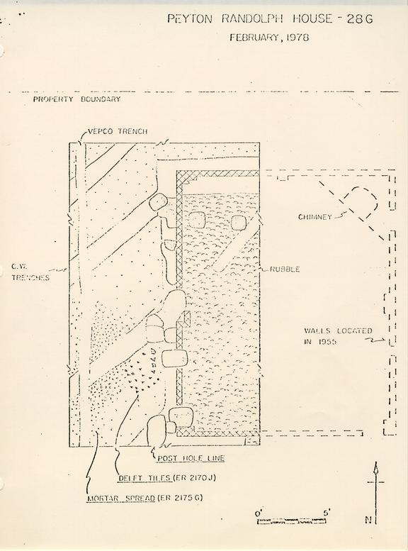
The object of the excavation was to explore the small, ancillary structure at the northwest corner of the Peyton Randolph lot. Based on the 1955 excavation, it measured 20'4" by 16'6". Rubble from the destruction of the building was found throughout its interior, but was left largely undisturbed, so that when excavations resume, it can be removed in a single operation. The wall remains were unusual, consisting of 4" wide brick foundations joining piers at the corners and at the center of each wall (see attached plan). The only intact pier was at the northwest corner, and measured 1'6" by 1'0", but was "stepped" to the west. The southwest pier had been largely destroyed by a later post hole, but was 1'3" east-west. Post holes damaged the foundations in other places, destroying the north half of the center pier on the west wall. This pier was 1'0" wide and as much as 3'0" long. If so, it would not match the pier on the east wall as found by Knight in 1955. It may be, of course, that only the surviving bricks of the east pier were recorded, and that its original form was larger. As the site slopes to the west, the walls followed this slope, with the west foundation one course deeper than the north and south foundations.
Stratigraphy Associated with Structure A
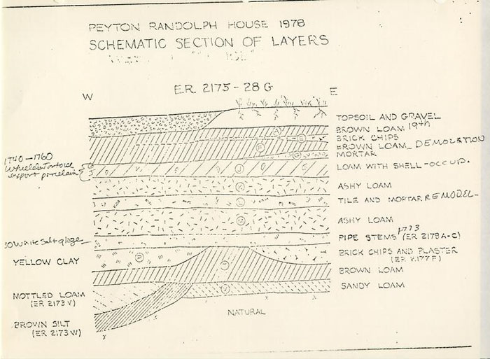
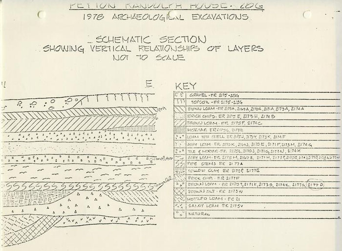
West of Structure A, C.W. trenching had cut through layers of occupation material associated with the structure, and in the act of exposing the foundations, the excavation had completely separated the building from the stratigraphy surrounding it. As the excavation unit E.R. 2175 contained portions of each layer associated with the occupation of Structure A, the excavation register identification letters for that unit will be applied to each layer. Please see the attached chart and schematic section
4No trace was found of the construction of Structure A, but a 2" thick layer of brown loam (E.R. 1775T) lay above a buff sandy loam (E.R. 1775V) which sealed the natural and should represent the preconstruction soil, as it did not contain any artifacts. The brown loam, however, yielded a number of finds, including several sherds of white salt glaze ware which first appears ca.1730. Cutting into this layer were two deposits: a yellow clay (E.R. 2175P) seems to have been used to fill in a depression southwest of the structure; and a pocket of brick chips and plaster fragments (not in E.R.2175, assigned E.R.2171J, 77F) sloped eastward toward the wall of Structure A, but had been completely removed by the 11" wide C.W. trench along the wall. It seems likely that the pocket continued to slope down toward the wall, and that the deposit represents a reconstruction or addition to the building. Note that plaster fragments among the finds indicates that the pocket was not filled with construction debris, as was originally thought, but with destruction debris, albeit on a limited scale.
The fairly flat surface presented by the infilling of these depressions was covered by a 1" thick layer of soft loam containing in places more pipe stems than soil (E.R.2179A-C). The distribution of the pipe stems has indicated a point of disbursal about 8'0" from the northwest corner. Small pieces of bottle glass were found among the pipe stems; both give every indication of having been the result of daily sweepings out of a door and into the front yard and street. Preliminary analysis of the pipe stems undertaken by the Research Associate has yielded a mean hole diameter of 4.18 for 6265 fragments, with an extrapolated date of 1772.69. This date seems considerably later than is suggested by the other 5 artifacts, which continue with the post-1730 white salt glaze ware as the latest datable object.
Covering the pipe stems, and containing a good quantity of stems also, was an ashy loam (E.R.2175M,N) which spread throughout most of the area west of the building. This ashy soil was sealed by a 1" thick layer of loam containing mortar, plaster, brickbats, and what made the deposit exceptional, hundreds of pieces of delft tiles in both blue and purple designs (E.R.2175L). The location of the individual fragments formed a pattern, suggesting that the tiles had been discarded through an opening in the west wall about 7'0" from the southwest corner, possibly an open window used by workmen making alterations.
Sealing the tile deposit was another widespread layer of ashy loam (E.R.2175K) attributable to normal occupation of the building. This ashy soil in turn was covered by a deposit of brown loam containing numerous shall fragments (E.R.2175J). A 3" thick mortar spread (E.R.2175G) lay on top of the shell layer. It was sealed by a 2" thick layer of brown loam (E.R.2175F, H) below lens of red brick chips (E.R.2175E). Above these layers was a disturbed brown loam (E.R.2175A) which contained 19th century artifacts. The brick chips may have been caused by the 19th century demolition of one of the late colonial? structures nearby. The mortar spread, however, appears to represent the demolition of Structure A. Finds from the mortar, and from the occupation layer below it, give a date after ca.1740. The artifacts suggest a high standard of living, with quality wine glasses and pottery of Wieldon tortoise shell ware, and much export porcelain, including some of the rare "bianco supro bianco" variety. No sherds of creamware or of Wedgwood's green glazed or pineapple 6 earthenwares have been found within the layers associated with the life of the building, suggesting that the house was no longer standing in the 1760's.
Interpretation of Structure A
Throughout the excavation of the little building, a major problem has been its identity. The placement of this structure at the far end of the lot, behind the other service buildings, is in apparent contradiction to the quite fine range of ceramics and glassware, not to mention the delft tiles found in association with it. We have suggested that Structure A served as a dower house for Lady Randolph after Peyton was married in 1746. Her death soon after 1754 is close to the estimated demolition date of the house (ca. 1760), and the quantities of tea-related ceramics and the large number of pins recovered may denote a female occupant. Certainly the quality of the items found suggests a person of considerable wealth, or taste.
Evidence for the earlier life of the building pointed to a different occupant and a different sex. Refurbishing the interior had sealed earlier occupation levels with a spread of mortar, plaster, and tiles. In those levels, material thought to have been swept out toward the street consisted almost entirely of pipe stems and bottle glass, suggesting that drinking and smoking were customary activities. These finds, and the placement of Structure A away from the main house, have lead us to believe that the building may have served as a law office. Finds from the brick chips and plaster-filled pockets give a date in the 1730's, and as the plaster suggests a renovation rather than a construction, the building may have been standing for some years.
7Thus the office could have been built by Sir John Randolph after acquiring the property in 1724, and its renovation may have followed his death in 1737. The office was converted to a dower house for Lady Randolph by 1751, when it was recorded that Peyton was living in the Nicholson Street house (see Research Report for Colonial Lots 207 and 237, p. 10). The building was presumably pulled down in the late 1750's after Lady Randolph's death.
LATER FEATURES
Fence Lines
No post holes were found associated with Structure A. A series of fences lay along the west wall of the building, and appeared to turn east about 10' from the north property boundary. All post dated the destruction of Structure A, cutting through its foundation and into the rubble within the walls. It is possible that some of the fences indicated by the incutting holes continued north out of the excavated area. A series of holes centered on a line 2'0" west of the foundation appear to be the latest because they cut the holes to the east. The western holes were at 9'0" intervals, and the placement of the next in the series would have been on the property boundary.
EARLIER FEATURES
There was only one feature which could be determined to have been in existence before Structure A. A ditch ran northwest-southeast across the site, continuing under the wall foundation of the building. The ditch was 4'0" wide and 1'02" deep with sloping sides and a curved bottom. It was filled with humic gray loam (E.R.2173U, W), containing only a few nail fragments. The ditch can be no later than the first quarter of the 18th century, after which the office was constructed. Indeed, the 8 fact that the cutting runs totally askew to the orientation of the colonial city, suggests that it preceded the layout of the town, and so was probably a Middle Plantation field ditch.
LAYER CORRELATION CHART
| 2175A | = | 2169A; 70A; 71A; 73A; 74A |
| 2175E | = | 2173H; 2174B |
| 2175H,F | = | 2174C |
| 2175G | = | 2174E |
| 2175J | = | 2179Y; 71E; 73K; 74F |
| 2175K | = | 2169J; 70E; 71F; 73M; 74G |
| 2175L | = | 2170J; 71G; 73N; 74H |
| 2175M,N | = | 2169Z; 71H; 73P, R; 74J; 77D; 78A |
| 2175P,S | = | 2177E |
| 2175T | = | 2171K; 73S; 74K; 77G; 78D |
| 2175V | = | 2173T; 77H |
 PEYTON RANDOLPH HOUSE 1978
SCHEMATIC SECTION OF LAYERS
 PEYTON RANDOLPH HOUSE - 28G
FEBRUARY, 1978
 PEYTON RANDOLPH
HOUSE
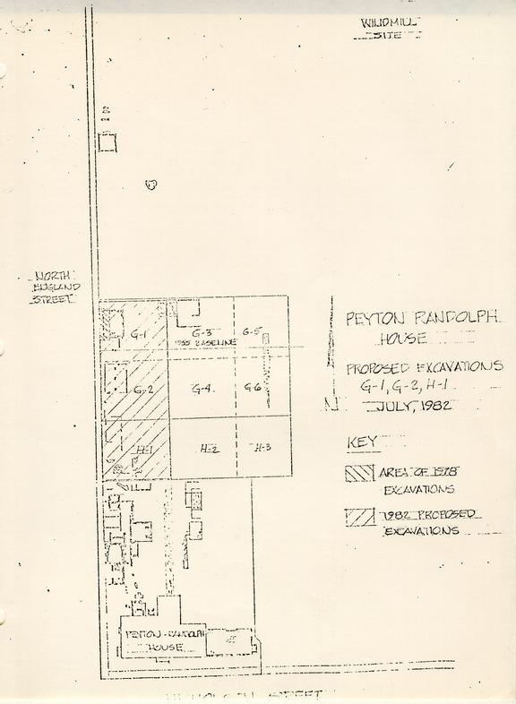
PROPOSED EXCAVATIONS
G-1, G-2, H-1
JULY, 1982
 PEYTON RANDOLPH HOUSE-28G
1978 ARCHAEOLOGICAL EXCAVATIONS
SCHEMATIC SECTION
SHOWING VERTICAL RELATIONSHIPS OF LAYERS
NOT TO SCALE