Block 28 Building 5B Lot 233, 14Originally entitled: "Archaeological Report Block 28, Area A (Philip Ludwell Tenement) 1942"
Colonial Williamsburg Foundation Library Research Report
Series - 1532
Colonial Williamsburg Foundation Library
Williamsburg, Virginia
1990
ARCHAEOLOGICAL REPORT
BLOCK 28, AREA A
(Philip Ludwell Tenement)
During the months of February and March 1932, archaeological excavations were executed at the site of what is possibly that of the Philip Ludwell Tenement.
The research report, dated April 23, 1940, is very vague in regard to the exact type or location of the Philip Ludwell Tenement because of lack of data concerning this site. The Frenchman's Map shows a fairly large building on this site indicating the definite possibility of a building once having existed there. When a modern building was demolished in 1932, the northwest and southwest corners of an old foundation were partly uncovered. Also uncovered was a 14' - 0" x 8' - 0" area of old brick floor paving.
A more complete archaeological investigation of this site was carried out in 1940. After carefully removing all debris and fill from this site, the remains of a building foundation wall were exposed. This building had a full basement with an overall dimension of 37' - 3¼" x 27' - 3½". The floor of the basement had two levels, the front or south portion being approximately 2' - 0" higher than the rear. (See section A-A on archaeological drawing.) Originally these two floor levels were separated by a partition wall which was destroyed when a 3" terra cotta drain pipe was laid from the present Randolph-Peachy House basement to the ravine dust to the east of this foundation. It may be noted that the drain also passed through the original basement foundations of the recently-reconstructed east wing of the Randolph-Peachy House. This drain was evidently laid sometime during the first or middle part of the nineteenth century after both the Randolph-Peachy House east wing and the Philip Ludwell 2 Tenement had been torn down and the basements backfilled with debris.
Fragmentary remains of a large outside chimney were found on the east end of the foundation. It was impossible to determine the exact dimensions of this chimney as most of the original bricks were removed when a modern brick school building was constructed, overlapping the east end of the colonial foundation.
The only evidence of outside steps leading to the basement were discovered at the southeast corner - south of the chimney. The floor paving is the corner was cracked and well worn, showing evidence of having had considerable rear in connection with the steps.
Remains of two 9" brick walls, seven feet apart and running north and south, were discovered near the center of the building. These foundation walls probably supported the partition walls at first floor hallway. Inside steps to the basement were also probably located within these walls although no indication of such was found. A passageway connecting the basement hall with the east and vest basement rooms appears to have been located next to the south foundation wall, This seems to be a logical place for a connecting passageway as it is on line with the outside steps to the basement.
A considerable amount of floor paving was found in the central and east portion of this foundation, but no evidence of paving was found in the west portion, other than a layer of well-packed shell mortar and brick bats. It may be noted that much of this paving was laid in a different pattern from other basement paving found in archaeological excavations by Colonial Williamsburg. (See detail on archaeological drawing.)
Four different-size bricks were used in the construction of this 3 building, including many bats. The predominating brick size was 9" x 4¼" x 2½" with a color range from light red to buff. The mortar used in the brickwork was oyster shell and the type of bond was English.
Nine feet south and on centerline with the hallway is a 19" brick wall, 9' - 11" in length. This showed strong evidence of having originally been a brick step or possibly base for stone step. The area between this foundation and the south wall of the building was not excavated on account of an existing maple tree.
See photographs N-6257, N-6258, N-6259 and N-6260.
James M. Knight
Colonial Williamsburg
Architectural Department
June 17, 1942
Block 28 - Area A.
To: H. R. Shurtleff, Director, Research & Record Department.
From: H. S. Ragland.
Subject: Archaeological Report - Foundations - Philip Ludwell's Tenement.
Date: Williamsburg, Virginia, October 27, 1932.
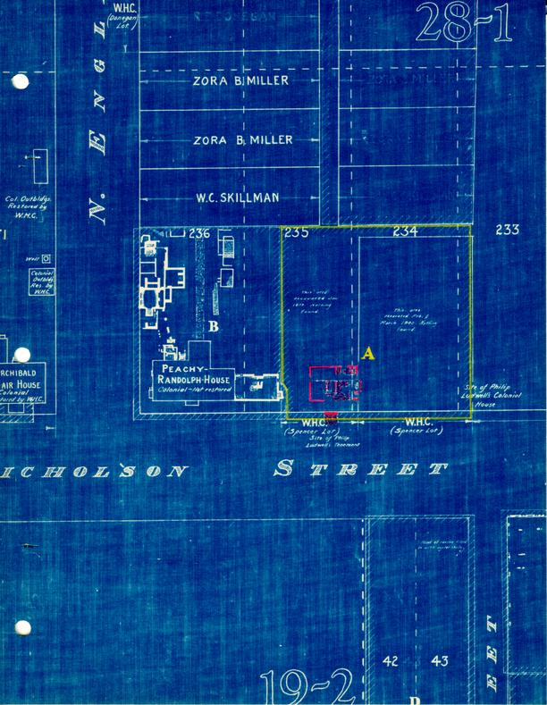
Submitted herewith is an archaeological drawing showing fragments of a colonial foundation found by excavation on the Spencer lots, on the north side of Nicholson Street, at the site, according to research report, of a colonial tenement owned by Philip Ludwell.
As shown on the drawing, the northwest corner of the foundation was found under the existing frame house, rented by the Williamsburg Holding Corporation at the present time, to George Campbell; the southwest corner in the yard, south of the house; and the basement paving between the frame house and the brick house, leased by the Williamsburg Holding Corporation now to Mr. Robert Trimble. A part of the north wall was found adjacent to the brick house, so apparently it is standing on the eastern part of the tenement site. It is possible that a part of the east foundation wall of the tenement still exists. No excavations were made under the brick house, and only narrow trenches under the frame house at planes where there was no danger of weakening its foundations. However, if the two houses are removed, additional digging should be done, and the area thoroughly explored.
Herbert S. Ragland
HSR:vbl
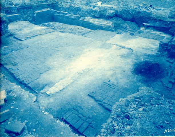 Photograph N 6257
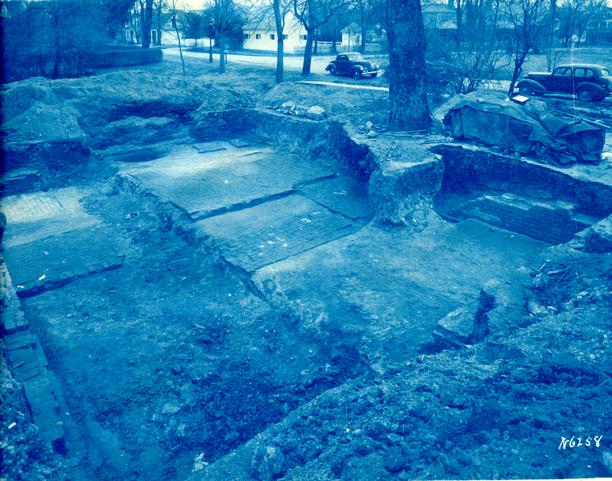 Photograph N6258
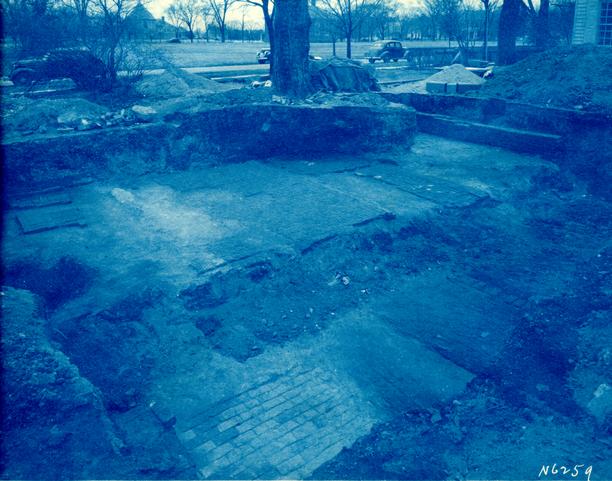 Photograph N 6259
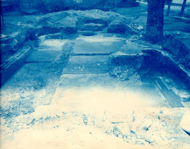 Photograph [6260]
D R A F T
Archaeological Report
Philip Ludwell Tenement Foundation
Block 28, Area A
The research report (see report) is very vague in regard to the exact type and location of the Philip Ludwell Tenement on account of the lack of historical data concerning this site. The Frenchman's map shows a building on this site and gave the first definite knowledge of a foundation being located here.
In 1932 when a modern building which stood on this site was demolished, the northwest and southwest corners of this foundation were partly uncovered. A small area of brick paving was also exposed near the southeast portion of the basement.
During the months of February and March, 1940, archaeological excavations were resumed in this area. After carefully removing all debris and fill from this site, the remains of a brick foundation wall were exposed, whose dimensions were 37'-3¼" x 27'-3½", with full basement. The floor of the basement had two levels, the front or south portion being approximately 2' higher than the rear (See section A-A on archaeological drawing). Originally these two floor levels were separated by a partition wall which was destroyed when a 3" terracotta drain pipe was laid running from the present Randolph-Peachy House basement to the ravine just to the east. It may be noted that this drain also went through the original basement foundation of the recently reconstructed east wing of the Randolph-Peachy House. It was probably laid sometime during the first or middle of the 19th century after both the Randolph-Peachy House East Wing and the Philip Ludwell Tenement had been demolished and the basements filled with debris.
Fragmentary remains of a large outside chimney were found on the east end of this foundation. It was not possible to determine the exact dimensions of this chimney as most of the original bricks were removed when a modern brick school was constructed overlapping the southeast corner of this site.
The only evidence of outside entrance steps to the basement was near 2 the southeast corner, just south of the chimney. The floor paving in this corner showed considerable evidence of wear and appeared to have been used as a floor level landing at the bottom of the steps.
Remains of two 9" inside walls, 7' apart and running north and south, were found near the center of the building. These walls probably served as partition walls in the basement and also supported walls on the first floor which formed a hallway. Inside steps leading from the first floor to the basement were probably also located within these walls.
A passageway connecting the basement hall with the east and west basement rooms appears to have been located next to the front or south foundation wall. This seems to be a logical place for a passageway as it is on the east and west center line of the outside basement steps.
There were four different size brick used in the construction of this foundation, including many bats. The predominating brick size was 9" x 4½" x 2½", while the color range was from light red to buff. The bricks were laid in English bond with oyster shell mortar.
A considerable amount of floor paving was found in the central and eastern portion of this foundation, but no evidence was noted in the west section other than a well packed layer of brick bats and shell mortar. Much of this paving was laid with a definite pattern as shown in detail on the archaeological drawing. The average size of this paving was 8½" to 8¾" x 4" to 4¼" x 2½".
Nine feet south and on a center line with the hallway is a 19" foundation wall 9'-11" in length. This showed strong evidence of having originally been a brick step or base for a stone step. The area between this foundation and the. building could not be excavated on account of an existing maple tree.
J.M.K.
Archaeological Report
BLOCK 28, AREA A
(Philip Ludwell Tenement)
Block 28, Bldg 5B
During the months of February and March 1940,1932? JMK check archaeological excavations were
executed at the site of what is possibly that of the Philip Ludwell Tenement.
The research report (which see) dated April 23, 1940 is very vague in regard to the exact
type or location of the Philip Ludwell Tenement on account because of lack of data
concerning this site. The Frenchman's Map shows a fairly large building on this
site and gave indicating the first definite possibility of a building once having existed
there. When a modern building was demolished in 1932, the northwest and
southwest corners of an old foundation were partly uncovered. Also uncovered was
a 14' - 0" x 8' - 0" area of old brick floor paving.
A more complete archaeological investigation of this site was carried out in
1940. After carefully removing all debris and fill from this site, the remains
of a building foundation wall were exposed. This building had a full basement
with an overall dimension of 37' - 3¼" x 27' - 3½". The floor of
the basement had two levels, the front or south portion being approximately 2' -
0" higher than the rear. (See section A -A on archaeological drawing).
Originally these two floor levels were separated by a partition wall which was
destroyed when a 3" terra cotta drain pipe was laid from the present
Randolph Peachy House basement to the ravine just to the east of this
foundation. It may be noted that the drain also went passed through the original
basement foundations of the recently-reconstructed east wing of the
Randolph-Peachy House. This drain was evidently laid sometime during the first
or middle part of the
2
nineteenth century after both the Randolph Peachy Home east wing and the
Philip Ludwell Tenement had been torn down and the basements backfilled with
debris.
Fragmentary remains of a large outside chimney were found on the east end of the foundation. It was impossible to determine the exact dimensions of this chimney as most of the original bricks were removed when a modern brick school building was constructed, overlapping the east end of the colonial foundation.
The only evidence in the remaining walls of outside steps leading to the
basement were discovered at the southeast corner - on the
south side of the chimney. The
floor paving in the corner was cracked and well worn, showing evidence of having
had considerable wear in connection with the steps.
Remains of two 9" brick walls, seven feet apart and running north and
south, were discovered near the center of the building. These foundation walls
probably supported the partition walls of the a first floor
that formed a hallway. Inside steps to the
basement were also probably located within these walls although no indication of
such was found. A passageway connecting the basement hall with the east and west
basement rooms appears to have been located next to the south foundation wall.
This seems to be a logical place for a connecting passageway as it is on line
with the outside steps to the basement.
A considerable amount of floor paving was found in the central and east
portion of this foundation, but no evidence of paving was found in the west
portion, other than a layer of well-packed shell mortar and brick bats. It may
be noted that much of this paving was laid in a different pattern from any
other other basement paving found in archaeological excavations by Williamsburg. (See detail
on archaeological drawing.)
Four different-size bricks mere used in the construction of this building, including many bats. The predominating brick size was 9" x 4¼" x 2½" with a color range from light red to buff. The mortar used in the brickwork was oyster shell and the type of bond was English.
Nine feet south and on centerline with the hallway is a 19" brick wall,
9' - 11" in length. This showed strong evidence of having originally been a
brick step or possibly base for stone stepporch foundations. The area between this foundation and
the south wall of the building was not excavated on account of an existing maple
tree. .
See photographs N 6257, N 6258, N 6259, N 6260.
J.M.K.
June 17 1942
Colonial Williamsburg
Architectural Department