Booker Tenement (449 Nicholson Street) Archaeological Report, Block 27 Building 4 Originally entitled: "Excavations around the Building Currently Known as the Redwood Ordinary 1976 Block 27 Area D"
Colonial Williamsburg Foundation Library Research Report Series-1516
Colonial Williamsburg Foundation Library
Williamsburg, Virginia
1990
EXCAVATIONS AROUND THE BUILDING CURRENTLY KNOWN AS THE REDWOOD ORDINARY
1976
Block 27 Area D
| Introduction | 1 |
| History | 1 |
| Archaeology | 4 |
| Artifacts | 10 |
| Conclusions | 12 |
| Appendix I | 15 |
| Figure 1: Frenchman's Map and Location of Lot | Following p. 1 |
| Figure 2: Archaeological Plan | Following p. 4 |
| Figure 3: Section of Eighteenth-Century Feature | Following p. 5 |
| Figure 4: Section showing fill within bulkhead | Following p. 9 |
| Figure 5: Plan and perspective bulkhead | Following p. 9 |
| Following Appendix I | |
| Plate I: Excavated eighteenth-century features. | |
| Plate II: Interior of cellar at bulkhead location. | |
| Plate III: Bulkhead fill from west. | |
| Plate IV: Excavated bulkhead area from east. | |
| Plate V: "Redwood Ordinary" from Nicholson Street ca.1920. | |
| Plate VI: "Redwood Ordinary" and "Lindsley House" from west. | |
| Plate VII: "Redwood Ordinary" from "' Nicholson Street, 1933. | |
| Plate VIII: "Redwood Ordinary" from Nicholson Street, 1973. |
EXCAVATIONS AROUND THE BUILDING CURRENTLY KNOWN AS THE REDWOOD ORDINARY
1976
Introduction
In preparation for the restoration of the building known as "Redwood Ordinary," Block 27, Archaeological Area D, archaeologists were dispatched to study the soil outside the structure and adjacent to its foundations where information pertinent to the construction and life of the dwelling might be found. Of prime interest was the evolution of the front porch and locating a bulk-head in the north or rear wall. (Figure 1)
The area of the nineteenth-century house was excavated with thoughts of the possibility of an earlier foundation being used to support the extant structure. Indeed, the finding of the eighteenth-century features on the site would not be surprising as the lot was part of a parcel of land bought for the first time in 1712.
History
Compiling a history of the lot where the "Redwood Ordinary" now stands is complicated by two factors. First, the name Redwood should not be associated with this structure. John Redwood, jailor and keeper of the capitol, held title to Lots 272, 273, 61 and 62 — not Lot 275, the location of the structure under discussion. He did own an ordinary, but it was on Lots 61 and 62 near the Capitol.1
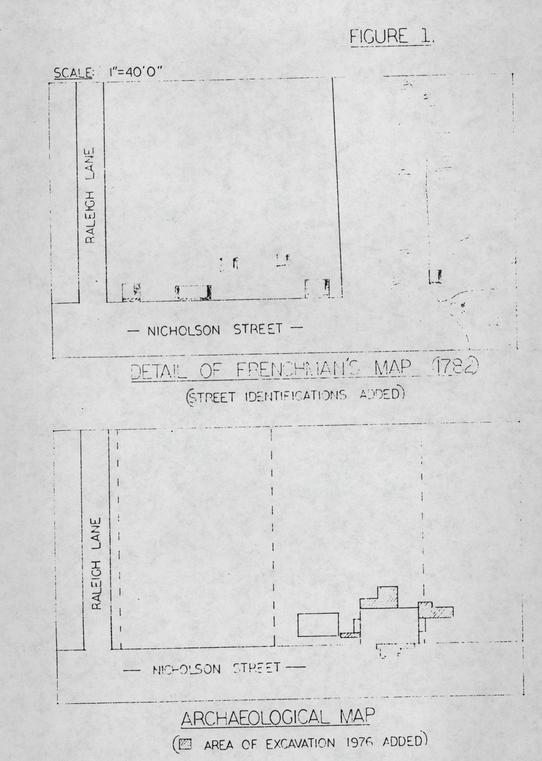 FIGURE 1.
ARCHAEOLOGICAL MAP
Compounding the problem is a plan of the city that Mr. Paul Buchanan of the Department of Architecture has drawn, using archaeological and archival records, showing "Redwood" located on Lot 276. The house history for Lots 274 and 275 has provided the majority of the historical references for th1s report,2 but no report was written on the adjoining eastern lot, #276, though both plots were purchased by Jean Marot in 1712.3
Marot had purchased property on Duke of Gloucester Street in 1708, where he operated an ordinary, and subsequently acquired four lots (274, 275, 276, 277) on Nicholson Street, March 14, 1712.4 Five years later Marot died, leaving his widow one-third of his holdings with the remainder to be given to his daughters.5 Mrs. Marot remarried and continued to operate the ordinary until she moved to Amelia County in 1738, where she died at the home of her daughter, Edith Cobbs, in 1742.6
The chain of title from Marot to his daughters has not been established, but Mrs. Edith Cobbs bequeathed two lots in Williamsburg to her son Samuel at her death in 1761.7 The same year the land was sold by Samuel Cobbs to his cousin James Shields III of Williamsburg. Lots 274 and 275 are the only holdings listed in 3. this transfer.8
Shields did not keep the property long, selling it to John Greenhow March 6, 1762.9 Robert Greenhow became owner at his father's death, and presumably held title at the time of his own death in 1787.
Further references to the property are found in the local tax records. Benjamin White is listed as the proprietor of Lot 274 in 1798.10 Samuel Harrison paid taxes on Lot 275 in 1805.11 Neither of these changes in title can be located. An anomaly here is that the College Map (ca. 1791) and the Bucktrout Map (ca.1803) both show White on #274 but a Wentworth on #275.
Harrison paid taxes on #275 until 1820 when he transferred the property to the estate of Wentworth Burwell.12 Burwell must therefore be the person noted on the two aforementioned maps as there were no Wentworths in the city and Burwell was paying taxes in town during the period.13
In 1823 Richard Booker bought the western half of Lot 275 from the Burwell estate,14 and improved the property as is evidenced by a higher taxation rate.15 His dwelling was probably the Lindsley House, whose foundations are now visible to the west of "Redwood."
4.The estate of Wentworth Burwell was charged taxes on the eastern portion of Lot 275 until 1850.16 No other owner is listed until 1873 when one John Lee took possession.17
This study of the history of the lot has provided a look at the various owners of Lots 274 & 275, but provides little information as to who built the extant structure on #275 or when it was constructed.
Archaeology
The archaeological investigations at "Redwood Ordinary" were primarily concerned with the location of features associated with the extant building and structural additions related to it; therefore, excavations were carried out only in areas adjacent to the dwelling. A survey of the remainder of the property was postponed until a full scale archaeological project could be executed. (Figure 2)
A 12'6" x 3'0" trench (E.R.2138) was dug to the west of "Redwood" and south of the chimney on that side. This area of excavation stretched between the dwelling and the foundations of the "Lindsley" House. Here were found seven post holes (E.R.2138G, H, J, N, P, R, S), all of which yielded either modern wares or no datable artifacts. An eighth post hole was located, but unlike the previously noted features which were either near "Redwood" or at the corner of the "Lindsley" foundations, it was near the center of the trench and more northerly in location. The polychrome whiteware recovered date this feature to
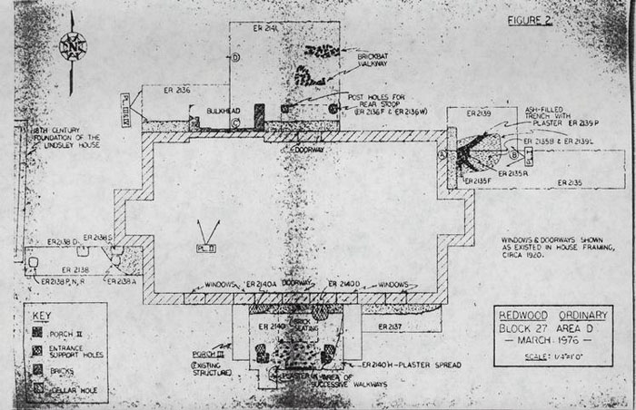 FIGURE 2
5.
the mid-nineteenth century.
FIGURE 2
5.
the mid-nineteenth century.
Also seen in this trench was the backfilled edge of the cellar hole (E.R.2138 B). The mixed clay filled feature extended westward around the chimney allowing the construction of the cellar walls, which are of American bond, to be seated to form a foundation. Natural clay was then redeposited along the outside of the walls. Evidence of the cellar hole was found abutting the building in all excavation areas.
Along the east wall, north of the chimney, a 12'6" x3'0" trench (E. R. 2135} with a 7'6" x4'6" northern extension (E.R.2139) was dug. Only strata dating post-1850 were noted in the eastern-most portion of the trench, but the area near the building contained several features.
The only definite eighteenth-century feature (E.R. 2135B and E.R. 2139E, F, G, L, P, and R} found on the site was in this area. Generally rectangular in shape, the feature cut into natural clay on the south and natural and brown loam (E.R.2139N) on the north and was filled with, in sequence, dark brown loam (E.R. 2139E}, a thin layer of shell mortar (E.R.2139G}, a stratum of dark brown ashy loam (E. R.2139F}, and ash deposit (E.R. 2135B & E.R.2139L}. (Figure 3} These strata were removed revealing edges of the 4'9" x3'9" depression that were reddened from heat. Both the natural clay and brown loam had been effected. A slight downward slope to the west was apparent to a 3'9''x1'4" plateau (E.R.213SF} which centered around a 1'6"x1'4" hole. On the flat area south of the hole were two laid but unmortared bricks. No bricks were on the northern flat area but some were found in the hole (E.R. 2139R}
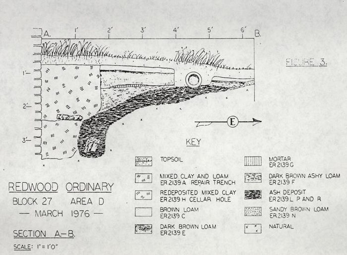 FIGURE 3
6.
The fill atop the slope was the black ash (E.R.2139L). At approximate 45° angles to the north and south of the hole, two troughs were cut into the natural. The southern contained only ash, but the other (E.R.2139D) contained white-washed shell based plaster.
FIGURE 3
6.
The fill atop the slope was the black ash (E.R.2139L). At approximate 45° angles to the north and south of the hole, two troughs were cut into the natural. The southern contained only ash, but the other (E.R.2139D) contained white-washed shell based plaster.
Artifacts recovered from the levels of strata suggest a sequential filling of the feature. From the ash and brick-filled hole came a horseshoe of the mid-eighteenth century. The overlying black ash contained black-glazed coarseware of ca.1750 and a George II half-penny of 1730. The layers above the ash were definitely deposited following whatever heat-related activity had ceased. Unaffected by heat themselves, the strata lay against the reddened edges. Both the dark brown loam and dark brown ashy loam contained creamware dating no earlier than 1769.
A mixed, clay-filled trench (E.R.2139C and E.R.2139A) cut the eighteenth-century feature on the west and the cellar hole for the building (E.R.2135E -E.R. 2139H) on the east and north. The trench, 3" wider to the east and ½" shorter to the north than the cellar hole, cut the hole and overlayed it also. At the bottom of the later excavation was a layer of brown loam and clay with brick fragments, possibly left from repairs to the foundation.
The fill beneath, that of the cellar hole, was also a re-deposited clay. The cellar hole noted in E.R.2135 and E.R.2139 is 1'1" wide to the east, but the width of the hole to the north as seen beneath a modern foundation is only three inches. (Plate I)
This northern edge of the cellar excavation was noted again in E.R.2136 along the northwestern half of the rear wall of the extant structure where the hole had widened to 1'1" in width. A similar widening was noted in front of the house in squares E.R.2137 7. and E.R.2140. Here again the hole is 1'1" in width near the center of the dwelling and narrows to 4" near the southeastern corner of the house.
Following removal of floorboards from the extant front porch, excavation began beneath it to locate remains of any earlier structures. The remnants of two brick piers, a support footing, and two successive sidewalks, in addition to four post holes and a layer of plaster, were located within the square along with the edge of the aforementioned cellar hole.
Post holes E.R.2140A and E.R.2140E cut the cellar hole fill (Figure 2). Both contained brick fragments. The western feature (E.R.2140E) had a mold 3" in diameter above a brick which had been placed flat in the bottom of the post hole. The eastern hole contained nineteenth-century bottle glass, but no artifacts were recovered from its companion.
South of, and on line with, the two post holes, were two brick piers with a white limestone mortar, and two post holes (E.R.2140E and E.R.2140G) west and east respectively. Associated with the brick supports was a layer of painted, shell-based plaster (E.R.2140H), seen east of the eastern pier and south of the western. The two post holes are on the same north-south line as the piers. The western hole (E.R.2140F) butts the brick feature whereas the eastern (E.R.2140G) was cut into natural following the removal of one of the bricks from the pier's north face. This feature also cut the plaster layer and contained plaster fragments. Both the post holes and the plaster layer were devoid of datable artifacts.
Located between these features were the remains of two 8. successive sidewalks extending 3'6" north of the southern balk. The central portion of the walks was overlaid by a modern porch support and excavation could not be carried on in the immediate area. Three bricks of the later sidewalk, spaced at 10" intervals demark the north end of the surviving brickwork. The upper unmortared walk was laid of sharp edged brick, the majority of which are whole. The earlier, lower feature was constructed of previously used bats. Fill (E.R.2140M) removed from beneath the perimeter of the upper sidewalk contained oystershell and glass from the late nineteenth century.
Directly north of the three bricks denoting the end of brickwork, was a shallow depression measuring 1'5" x 1'5" x 3", containing a dark loam fill from which came a United States one-cent piece dated 1920. North of the depression were two laid but unmortared bricks. These bricks, which lay centered between the two northern post holes were seated on natural.
Excavations to the rear of the building were concentrated on an area east of the back steps to the northwestern corner of the house. The interior cellar walls in this section have an inset in the brickwork suggesting a bulkhead location. (Plate II)
Much modern disturbance was found against the northern wall of the cellar. Seatings for supports for twentieth-century house additions were present along with two electrical grounding rods. A foundation for a modern building enlargement cut into natural clay and fill along the western edge of the excavated area. (See Figure 2)
Removal of topsoil exposed a large area of lath marked and whitewashed plaster (shell based), intermixed with gray loam 9. (E.R.2136H and E.R.2141G), which overlay brick rubble, a portion of which had fallen in such a way that the bonding pattern was still partially discernible. Mixed with the rubble was gray loam (E.R.2136L) of the same nature as E.R. 2136H. Fragments of a molded glass goblet or compote base dating from the late nineteenth or early twentieth century were found adjacent to the southern edge of the articulated brick.
The gray loam and rubble were primarily confined within the cheeks of the bulkhead and the sloping hole dug for the entranceway. (Plate 3) Above the natural clay bottom of the slope and below the gray loam was a thin stratum of brown loam with mortar flecks. This layer dates no earlier than 1825 as evidenced by the whiteware recovered from it. (Figure 4)
The remains of the bulkhead cheeks were exposed and mapped. Measuring 8'0" east-west across the outside of the cheeks, the entrance had an interior width of 5'6" . The cheeks extended north three feet from the wall on the east, 1'6" to the west. (Plate IV) Evidence of another 1'6" of brick being robbed was also found on the west. (Figure 5) Remains of two brick steps were also found.
Two feet from the house and centered on the extant rear steps were two post holes (E.R.2136F and E.R.2136W) containing mixed clay fill cutting into natural. Post mold E.R.2136V was excavated in the eastern post hole (E.R.2136W) but no mold was found in the other feature. Brick seatings for posts similar to those found in front of the structure were found in both features. (Figure 2)
Also found at the rear of the house were the remains of a brickbat walkway (E.R.2141N 2'3" in width, oriented to the north
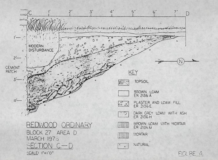 FIGURE 4
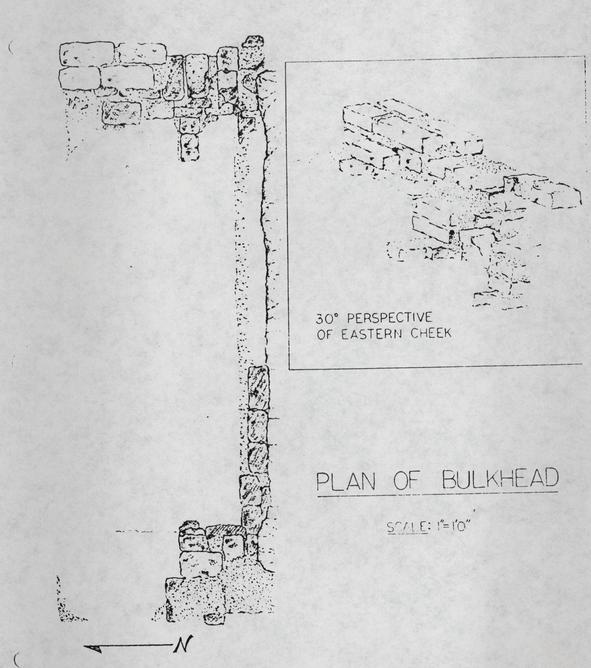 FIGURE 5
10.
of the post holes. A possible curve or branch to the east is suggested. Whiteware was found sealed by the sidewalk.
FIGURE 5
10.
of the post holes. A possible curve or branch to the east is suggested. Whiteware was found sealed by the sidewalk.
Artifacts
As is common in Williamsburg, the topsoil contained artifacts of many periods of human activity, from the eighteenth century to present.
The eighteenth-century feature produced many contemporary ceramics, but comparable wares were also found in strata across the site, the majority of which date as post 1825. Rhenish stoneware, white salt-glazed stoneware, English brown stonewares, slipwares, coarse earthenwares, delft-wares, and Chinese export porcelain were all recovered on the site.
Cream colored earthenware was concentrated around the eighteenth-century depression. Examples of "clouded ware" and hand painted, as well as plain, creamware were found in the feature.
Pearlware, which coexisted with creamware after 1785, was also excavated. Pieces of green and blue shell-edged, hand painted, and transfer-printed pearlware were recovered. A piece of a blue transfer-printed plate with the number 19 in red on the underside was removed from E.R.2136A.
White ware, or ironstone, a semi-porcelainous ceramic which was replacing pearlware in the market by 1820, was in use throughout the life of the extant structure. Most pieces found were undecorated, but examples of transfer-printed, hand painted, and silver gilded stone china were found. Of note is a mug with a silver overglaze decoration recovered from E.R.2136E.
Five sherds of whiteware had decipherable maker's markings. 11. From the topsoil of E.R. 2136 came a saucer marked ROYAL PATENT IRONSTONE BURGESS & GODDARD below the royal crest. A second piece from the same stratum bore ROYAL IRONSTON E above the royal crest of Great Britain, but the remainder of the plate was gone. From E. R.2134F, H, and K came sherds that crossmended, revealing the stamped legend STONE CHI[NA above BUR]GESS G[ODDARD) all beneath the royal crest.
E.R. 2136E produced the other two readable pieces. A plate stamped Royal Semi-Porcelain, ALFRED MEAKIN, ENGLAND with a crown above dates is post 1891.18 A saucer from the same manufacturer and date was marked ROYAL [IRONSTONE] over a crown, above ALFRE]D MEAKIN EN[GLAND.
A ceramic object of a different nature was a "china" doll's head with painted hair and features from E.R.2136H. Topsoil in E.R.2141 held a painted arm from a doll of the same type.
The earliest datable glassware from the site came from topsoil in E.R. 2140. Here, a bottle seal marked PYRMONT WATER of post 1770 was recovered.19
Fragments of colonial, nineteenth, and twentieth-century bottles were recovered in every excavated area. Two whole examples are a small perfume bottle marked HOYT & CO PERFUMERS over PHILA. from E. R. 2136B, and an unmarked molded inkwell in E.R.2136E.
Four metal objects are worthy of mention. Two are from the nineteenth or twentieth century. A lead spigot marked FENNS FAUCET 12. above N0. 3 above NEW YORK was from E. R.2136H. An ornamental brass cone bearing an eagle, found in the topsoil of the same square, is a plume socket from a helmet worn by United States mounted troops ca. 1872.20
The remaining metal items were from the eighteenth-century feature in E:R.2135 and E.R. 2139. A horseshoe of the mid-eighteenth century was recovered from E. R. 2139R.21 The shoe had thirteen nail holes and fullering.
A half-penny bearing the date 17[3]0 was in E. R. 2139L. This George "young head" coin could only have been minted that year as the "young head" coin was only minted from 1729-1739. The coin is a poor indicator of time because of the potentially long period of its use. As no copper coins were issued from 1755 to 1770, the coins previously in circulation were often long-lived.22
Conclusions
Redwood Ordinary was built during the second quarter of the nineteenth century and the foundations cut through an eighteenth- century feature of unknown function. The brick cellar foundation, consisting of bricks previously used (as evidenced by wear and by burning on subsurface areas), was seated in an egg-shaped hole and fill was deposited outside the walls for landscaping and sealing:
A bulkhead large enough to take a hogshead was an integral part of the cellar. A rear stoop at least 2'6" x 6'0" built post 13. 1825 was erected east of the basement entrance. A brick walkway sealing contemporary nineteenth-century artifacts was laid to the stairway.
At the front of the building a small porch or stoop approximately 4'0" x 4'0" was the first entrance stairway. Steps from this structure lead southward to successive walkways. (Figure 2) These later walks date to the late nineteenth century.
Before ca. l920 the porch was expanded to a 6'0" x 8'0" configuration supported on brick piers and wooden posts (E.R. 2140A and E.R. 2140D), with latticework enclosures and a stairway on the western side. (Plate V) The front elevation of the house in this photo shows four sash windows with shutters, and a porch roof sloping toward Nicholson Street. The shutters on the two center windows cannot be completely opened next to the porch because of support for the roof. This suggests a smaller front entranceway at an earlier date.
By 1927 the porch had reached its present configuration and only two first floor windows on the outside were present in the front of the house. (Plate VI)
Before this time, the plaster layer (E. R.2140H) had been deposited outside the brick piers of the second period porch. This plaster was probably thrown out the windows later removed. The post holes (E.R. 2140F and E.R. 2140G) were dug following the deposition of the plaster, probably as beam supports for the extant porch until the new brick piers were constructed.
This period of major changes is evidenced in the rear of the building in the area of the bulkhead. Whitewashed plaster of the same composition as that found in the front of the structure makes up a large amount of the fill in the robbed bulkhead 14. depression. A 1927 aerial photograph shows a rear porch but no bulkhead, the site of the latter being concealed beneath the porch's western foundation. It is probable that the bulkhead was filled at the time of extensive changes and the porch added. At sometime after 1933, an addition was built and doorways cut where rear windows had been. This extension stood until 1973 when it was demolished. (Plates VII & VIII) The modern post holes found adjacent to the "Lindsley" foundations were identified by the "Swem" and the 1933 photographs (Plates V & VII), which show a picket fence at that point. The remaining holes near the chimney of "Redwood" are probably from the fence shown in the "Swem" photograph.
From this information it is seen that the extant nineteenth-century house has had many changes. Several of the additions have since been removed by Colonial Williamsburg, but the further removal of modern features and the substitution of appropriate period features is necessary to return the house to its earliest form.
Footnotes
APPENDIX I
"Redwood Ordinary", Block 27, Archaeological Area D
| E.R.2135-27.C | 19'0" x 4'0" trench east of and abutting chimney base. |
| E.R.2135B-27.C | Post hole containing dark ashy fill, cut by cellar hole, 2'5" x 2'5" x 1'8". |
| E.R.2135C-27.C | Sandy mixed clay located next to structure wall and cutting E.R.2135B, 1'7" x 1'4" x 1"; a late repair trench. |
| E.R.2135D-27.C | Brown loam beneath E.R.2135C and adjacent to wall, 1'7" x 1'8" x 9", probably the remains of topsoil that had fallen into repair trench. |
| E.R.2135E-27.C | Trench beneath E.R.2135D & C contained mixed clay fill 4'0" extant x 1'2" x 1'7", also cuts E.R.2135B. |
| E.R.2135F-27.C | Bricks surrounded by ash. Feature is cut by E.R.2138E, 1'5" x 2'6" x 5". |
| E.R. 2136-27.C | 5'0" x 16'0" square next to north wall of building. |
| E.R.2136A-27.C | Brown loam covering majority of area, cut by several utility trenches. |
| E.R.2136E-27.C | Large area of plaster and loam fill, 10'9" x 5'0" x 10", deposited in depression of bulkhead entrance. |
| E.R.2136F-27.C | Post hole noted following removal of topsoil. Bricks were placed in bottom of hole supposedly to support posts for rear stoop. |
| E.R.2136H-27.C | Dark gray ashy loam fill surrounding brick rubble, 8'0" x 5'10" x 6". |
| E.R.2136K-27.C | Dark gray sandy fill with ash, the same as E.R.2136H, surrounds brick rubble. |
| E.R.2136L-27.C | Same fill as E.R.2136K but beneath collapsed wall and brick rubble. |
| E.R.2136M-27.C | Brownish loam with mortar bits located below E.R.2136L and above natural clay subsoil. |
| 16. | |
| E.R.2136V-27.C | Post mold with dark loam fill, 12" deep, has brick at bottom, 3½" circular hole. |
| E.R.2136W-27.C | Post hole with mixed clay fill, 10½" x 10¼" x 15". Two bricks at bottom of hole like E.R.2136F. |
| E.R.2137-27.C | A 7'0" x 4'6" square at the southeastern corner of building. |
| E.R.2137B-27.C | Cellar hole along wall contains mixed sticky clay. 11" x 7'0" extant x 2'22". |
| E.R.2138-27.C | A 3'0" x 9'0" trench south of western chimney. |
| E.R.2138A-27.C | Post hole cutting brown loam on into subsoil. |
| E.R.2138B-27.C | Cellar hole containing mixed heavy clay adjacent to building and chimney. |
| E.R.2138F-27.C | Post mold contained mixed loam and clay fill. 8" x 7" x 1'1". |
| E.R.2138G-27.C | Post hole for mold E.R.2138F, 12" x 12" x 12" square with mixed clay loam fill. |
| E.R.2138P-27.C | Post mold contained mixed loam and clay fill. 8" x 7" x 1'1". |
| E.R.2139-27.D | A 4'6" x 7'6" extension to the south of E.R.2135-27.C. |
| E.R.2139A-27.D | Cellar Hole along eastern wall from 18" to 13" in width and 15" deep, same as hole E.R.2135C. |
| E.R.2139C-27.D | Brown loam cut by E.R.2139A at western extant of square and covering most of square, from ½" to 3" in depth. |
| E.R.2139E-27.D | Layer of dark brown loam in depression. Was noted only west of utility pipe, possible fill of settled hole. |
| E.R.2139F-27.D | Layer of dark brown ashy sandy loam in depression beneath E.R.2139E, west of utility pipe also beneath a thin layer of mortar. |
| E.R.2139G-27.D | A thin ¼" layer of mortar along southern edge of square, 2'0" in length is below E and above F. |
| E.R.2139H-27.D | A section of cellar hole same as E.R.2135E beneath E.R.2139A, also cuts E.R.2139L. |
| 17. | |
| E.R.2139L-27.D | Ash deposit beneath E.R.2139F, which cuts brown loam E.R.2139C. Heat reddened edges are apparent along sides of hole in which the deposit sets. |
| E.R.2139N-27.D | Sandy brown loam in northeastern quarter of square located below E.R.2137L. |
| E.R.2138P-27.D | Trench with plaster located inside of ash deposit. |
| E.R.2139R-27.D | Hole cut into natural clay containing part of ash deposit and bricks, 1'6" x 1'4" x 1'5". |
| E.R.2140-27.D | A 7'0" x 10'0" square beneath present front porch. |
| E.R.2140A-27.D | Large irregular post hole adjacent to building, cuts cellar hole. Brick was found within hole. |
| E.R.2140D-27.D | Post mold for large hole next to building's wall, has brick placed at bottom and is 3" circular and 8½" deep. |
| E.R.2140E-27.D | Post hole for E.R.2140D located against wall 26" x 12" x 11", contains mixed loam and clay fill. |
| E.R.2140F-27.D | Post hole cut extant remnants of brick pier; 12" x 13" x 12". |
| E.R.2140G-27.D | Post hole containing mixed loam and plaster fill which cut plaster layer and mixed fill beneath plaster, 13" x 12" x 15". |
| E.R.2140H-27.D | Plaster layer cut by E.R.2140G and located southeast of eastern pier and also south of western pier. |
| E.R.2141-27.D | A 11'9" x 6'6" extension north of E.R.2136. |
| E.R.2142B-27.D | Gray sandy silt located above plaster scatter which is part of fill in bulkhead depression. |
| E.R.2141C-27.D | Brown loam overlaying brick rubble found in most of the area of the square. |
| E.R.2141E-27.D | Plaster layer in depression underneath brown loam and E.R.2141B. |
| E.R.2141F-27.D | Mixed brown loam covering full square beneath E.R.2141C and E.R.2141D as well as E.R.2141G. |
| 18. | |
| E.R.2141 G-27.D | Dark sandy loam below plaster layer above E.R.2141F, same as E.R.2136H. |
| E.R.2141N-27.D | Brick bat walkway located beneath stratum E.R.2141C. Walk has a northern and eastern orientation with sections of brick removed. |
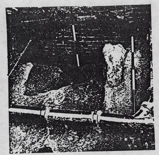 Plate I: View from the east showing foundations of "Redwood Ordinary" and a late addition. Cellar hole and repair trench have been excavated. Note plaster in trough of eighteenth-century feature and bricks in E.R.2139R. CW#76-INH-1285
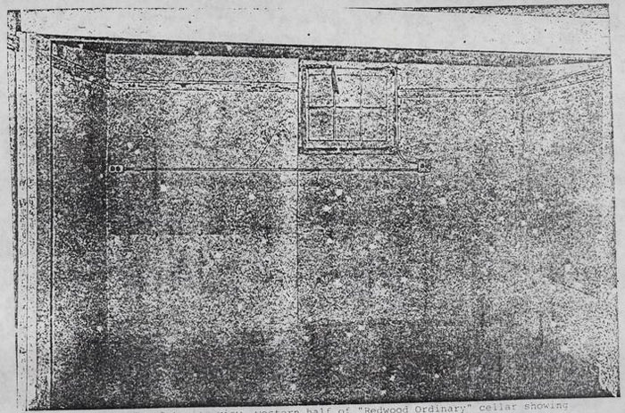 Plate II: Interior view, western half of "Redwood Ordinary" cellar showing depression in northern wall where bulkhead was located. CW-73-FD-583.
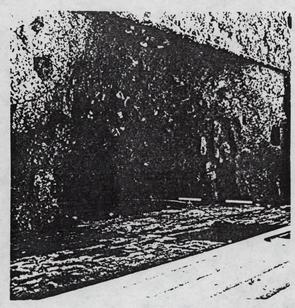 Plate III: View from the west of bulkhead fill following the removal of plaster and gray loam. Note concrete wall fill. CW#76-INH-1287.
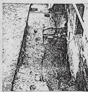 Plate IV: Bulkhead viewed from east after removal of all fill. Note post hole E.R.2136F at top center. CW#76-INH-1286.
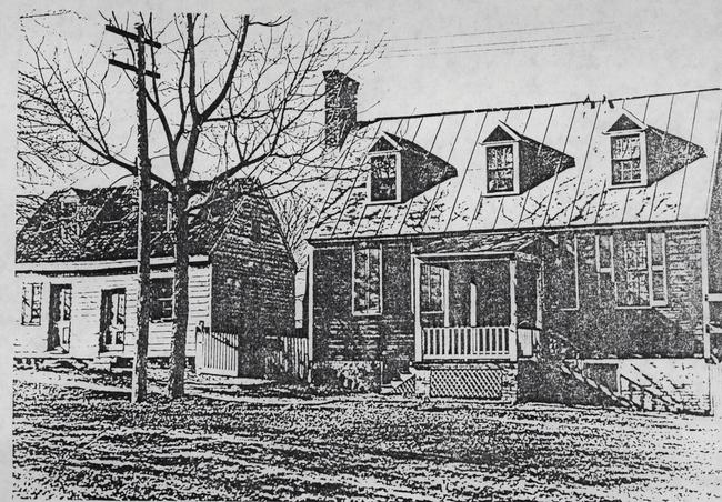 Plate V: Looking north from Nicholson Street. "Redwood Ordinary" and the Lindsley House circa 1920. Note four shuttered front windows and porch on brick piers with western stairway. CW#Swem 6.
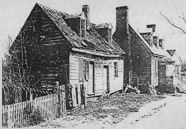 Plate VI: "Redwood Ordinary" and the Lindsley House seen looking east. Porch is the same configuration as present. (1928) CW#5 6-GB-241.
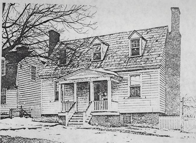 Plate VII: "Redwood Ordinary" 1933, with new house on "Lindsley" foundations. Note fence between structures. CW#N3624.
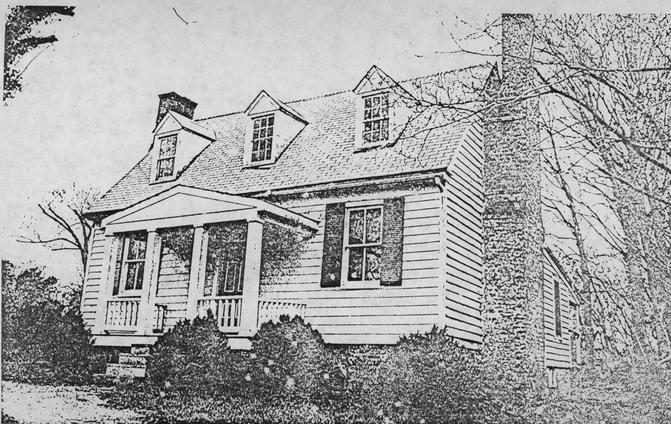 Plate VIII: "Redwood Ordinary" in 1973. "Lindsley House" has been removed. Northern addition to house still present. CW#73-FD-563.
 Gore lot, Block 27 56-GB-1838. Lafayette Street Extension.