James Geddy House Archaeological Report, Block 19 Building 11 Lot 161Originally entitled: "The James Geddy Site Block 19, Area B Colonial Lot 161"
Colonial Williamsburg Foundation Library Research Report Series—1446
Colonial Williamsburg Foundation Library
Williamsburg, Virginia
1990
THE JAMES GEDDY SITE
Block 19, Area B
Colonial Lot 161REPORT ON 1966 AND 1967 ARCHAEOLOGICAL EXCAVATIONS
| Page | |
| Table of Figures | |
| Table of Photographs | |
| Acknowledgments | |
| Introduction | 1 |
| Precis of Colonial Lot 161's History | 4 |
| The Archaeology of Lot 161 | 22 |
| The Geddy House | 22 |
| Structure A1 | 22 |
| Structure A2 | 24 |
| Structure B1 | 26 |
| Structure B2 | 31 |
| Structure C1 | 35 |
| Structure C2 | 35 |
| Possible Rebuilding of the Geddy Main House | 37 |
| The Outbuildings | |
| Structure D1 (kitchen-laundry?) | 38 |
| Structure D2 (northerly addition) | 43 |
| Structure D3 (west addition) | 44 |
| Structure El (kitchen) | 47 |
| Structure E2 (northerly addition) | 47 |
| Structure F (kitchen-laundry) | 48 |
| Structure G | 50 |
| Structure H (smokehouse) | 51 |
| Structure J (dairy) | 52 |
| Privy | 52 |
| Outdoor Furnace | 53 |
| The Wells | 54 |
| Well A | 54 |
| Well B | 55 |
| Well C | 59 |
| Walkways and Yard Metalling | 60 |
| Path A | 60 |
| Path B | 61 |
| Path C | 62 |
| Path D | 63 |
| Path E | 64 |
| Path F | 64 |
| Path G | 65 |
| Yard levels | 66 |
| The Drains | 70 |
| Drain A | 70 |
| Drain B | 71 |
| Drains C and D | 71 |
| Fence lines | 73 |
| Rubbish deposits | 76 |
| Architectural Evidence Found on the Geddy Site | 80 |
| The Artifacts (Summary) | 82 |
| Evidence of the Industrial Aspects of Lot 161 | 83 |
| The Domestic Remains | 87 |
| Conclusions | 88 |
| The Geddy House | 88 |
| The Outbuildings | 90 |
| Footnotes | 92 |
| Appendix I, Table of Brick Sizes and Mortar Composition | 97 |
| Appendix II, Summary of Excavation Register Numbers mentioned in the texts and illustrations | 102 |
| Appendix III, Dating of Excavation Register groups from the James Geddy Site | 110 |
| Appendix IV, Descriptions and Dating for the Architectural Items in Plate XXII | 135 |
| Figure 1Plan of earliest main structure features unearthed in 1967 | Following page 24 |
| Figure 2Plan of the c. 1750 main house showing relationship with earlier structure | " " 27 |
| Figure 3Sections of the juncture of north wing with the B1 main block | " " 28 |
| Figure 4Plan of the evolution of the extant main Geddy house | " " 30 |
| Figure 5Plan showing the conjectured evolution of structure D | " " 38 |
| Figure 6East/west section of stratigraphy in the DI structure's east room" " | 39 |
| Figure 7East/west section of stratigraphy in the D1 structure's west room" " | 40 |
| Figure 8Plan of foundations in 1930 and 1967 in the vicinity of the reconstructed kitchen" " | 47 |
| Figure 9Detail from Frenchman's Map showing relevant property with the lot numbers added" " | 49 |
| Figure 10Plan of features unearthed west of the reconstructed kitchen" " | 51 |
| Figure 11Plan of features discovered on the east side of Lot 161" " | 52 |
| Figure 12Section of Well A's infill" " | 55 |
| Figure 13Section of Well B's infill" " | 56 |
| Figure 14North/south section showing evolution of Path B" " | 61 |
| Figure 15Section of various walkway levels south of the extant main Geddy house" " | 66 |
| Figure 16Plan of the features unearthed south of the F1 kitchen structureFollowing page | 71 |
| Figure 17Plan of the features discovered outside Lot 161's westerly property line" " | 72 |
| Figure 18Geddy site master planOn back pocket | |
| Plate I | Aerial view of area immediately north of the main house in course of excavation |
| Plate II | Surviving foundations of the earliest main structure on Lot 161 |
| Plate III | The remains of the early main building's front porch |
| Plate IV | A portion of an earlier foundation protruding from beneath the existing building's west room chimney footing |
| Plate V | Elevated view of early main building's partially robbed north wall with the remains of a brick path associated with the structure |
| Plate VI | View of the eighteenth century underpinning of the main house's south wall with an earlier brick drain |
| Plate VII | Crude basement beneath the main building's north-west wing |
| Plate VIII | The remains of the bulkhead entrance to the cellar beneath the main structure's north wing |
| Plate IX | Rear view of Geddy House before restoration |
| Plate X | Original northeast corner of the extant main structure's northerly lean-to |
| Plate XI | Bulkhead steps and the remains of the west wall of a passageway which passed beneath the main building's northerly lean-to enroute to structure's main cellar |
| Plate XII | Surviving brickwork from the D1 outbuilding's central H-shaped chimney |
| Plate XIII | Elevated view of features unearthed in the D1 outbuilding's east room |
| Plate XIV | View of the brick flooring installed into the D3 west addition after the forge and working plinth had been abandoned |
| Plate XV | View of the D3 brass founding shop's forge and working plinth along with portions of the addition's east and south walls |
| Plate XVI | View of the pier supported structure's (G) southwest corner with the building's brick rubble path |
| Plate XVII | Excavated remains of a smokehouse along with a brick path associated with the outbuilding |
| Plate XVIII | View of a privy pit and its structure's southeast pier |
| Plate XIX | View of the outdoor forge's foundations discovered off the reconstructed kitchen's southeast corner |
| Plate XX | View of Well B in course of excavation |
| Plate XXI | View of the brick drain discovered outside the Geddy property's existing western fenceline |
| Plate XXII | Architectural fragments |
| Plates II through XXII appear in the rear of the volume. | |
ACKNOWLEDGEMENTS
The Department of Archaeology would like to thank the personnel in the Landscape, Research, and Architectural Departments for their assistance on the James Geddy project. In addition, we are most grateful to Mr. Douglas White for his surveying work. Mr. Daniel Barber was responsible for the photography and he, along with Mrs. Paulette Hancock, prepared the drawings.
Introduction
Archaeological work on Colonial Lots #161 was initially undertaken in 19301 and was followed immediately by the restoration of the main James Geddy II building.2 At the same time, a kitchen, with a lean-to attached, was reconstructed; a small frame structure (wood shed) was built and placed arbitrarily between the kitchen and the main house, and a well was fitted with a "local colonial type well head.3" Later, in 1953, additional archaeological work was performed on the eastern portion of the property;4 the findings resulted in the reconstruction of an east wing abutting the main dwelling and shop structure.
The 1931 excavation unearthed the remains of two presumed kitchen buildings, and at that time, it was decided to reconstruct on the foundations of the smaller and earlier of them. However, in 1965, when the decision was reached to make the Geddy House an exhibition building and to return the property to its late-eighteenth century appearance, it was resolved that the dependency should be torn down and replaced by the second, larger structure. This conclusion, no doubt, was based on the fact that the size and relative position of the latter kitchen (?) resembled the dependency shown on the Frenchman's Map of 1782 (?), (Figure 9).
The footing trenches for this new building having been partially dug, the quantities of artifacts found and those physically visible in section enabled this department to 2 request and receive time to perform a small rescue excavation. Mr. C. E. Hackett duly called a halt to construction activities and granted two days' grace for archaeological work. However, the time limitation was extended to ten days when it became apparent that the site was immeasurably rich in well-stratified artifacts. The findings,5 during this minimal archaeological investigation, in the spring of 1966, led to the theory that much of the property had been undisturbed by previous excavations and that a great deal of information concerning the social history of the site could still be retrieved.
The 1967 archaeological work began in May and continued through October of that year. This project was undertaken on the premise that the major buildings on the site were correctly restored or reconstructed, and that the chief purpose for excavation was to recover artifacts to aid in forming an accurate picture of the site's social history and, hopefully, to obtain more knowledge about the crafts practiced on the property. However, a number of discrepancies were found which have since necessitated a re-study of the architectural aspects of the main house in order that the property can more closely resemble its appearance when James Geddy II lived and worked there.
The discovery of new architectural evidence relating to the main building was considered something of a setback to. The reconstruction plans, but, the value of the archaeological 3 evidence of the Geddy crafts made the excavation one of the most rewarding yet undertaken in Williamsburg. The remains of a brassfounding shop, belonging to the James Geddy I period, were unearthed north of the existing main building. Its large, central, H-shaped fire place was in situ as was a small forge abutted to the south by a brick working plinth. A lead pattern for a harness buckle, found wedged between the plinth and the shop's south wall, indicated that the forge was used for brass casting, with the plinth serving as a work table. (Figure 5)
The recovered artifacts revealed at least two important facts about the colonial craftsman: Firstly, the quality of brass work made on the Geddy site was comparable to that generally available in England and other foreign markets, and secondly, the variety of ceramics and glassware used by the Geddy families was of surprisingly good quality.
A large quantity of unfinished brass castings were unearthed, among them shoe buckles, spandrels for clocks, watch keys, sword hilt parts, etc.; all of which were ornately decorated. It would seem that the American craftsman was able to compete, with some success, with the foreign markets and that, judging by the discarded household ceramics, at least one family of tradesmen in Williamsburg had businesses lucrative enough to enable them to purchase what we assume to have been some of the better things of life.
PRECIS OF THE JAMES GEDDY SITE HISTORY
Colonial Lot 161's history6 parallels and is, at times, identical to that of Lot 162. Therefore, it was necessary to review their pasts simultaneously, even though the 1967 excavation was almost entirely limited to Lot 161.7 The combined lots represented a highly desirable property, fronting on Duke of Gloucester Street, filling the entire block from Palace Street to Market Square and stretching northward to Nicholson Street.
The first owner of the two half-acre lots was Samuel Cobbs, of York County, who acquired the land from the trustees of Williamsburg in 1716. The transaction was recorded in the extant York County records dated February 5 (lease)8 and February 6 1716(release).9 The deed contained the usual stipulation that Cobbs must build on the land within twenty-four months or the property would revert to the Trustees. By 1716, Cobbs had three building alternatives, each of which was sufficient to hold both lots. He could construct:
"on each halfe Acre or Lott so granted one good Dweling House containing twenty Foot in width and Thirty Foot in Length at the least...."10or:
"build & finish one House fifty Foot long and twenty Foot broad..."115 or erect:
"one Brick House or framed House with two Stacks of Brick Chimney's & Cellers under ye whole House bricked forty Foot long & twenty Foot broad..."12Apparently Cobbs met the legal requirements since he held title to the property for three and one-half years.
York County records show that Cobbs sold Lots 161 and 162 to Samuel Boush, Jr., of Norfolk County in 1719. The transfer of title was finalized by lease on July l7th13 and by release14 the following day. There is no evidence that Boush ever lived in Williamsburg so it may be deduced that he purchased the land as an investment.
A thorough investigation by the Research Department failed to disclose the date that Boush sold Lot 161 to James Geddy. It had to be sometime prior to December, 1738, because, in that month and year, Geddy purchased Lot 162 described in the deed as "adjoining the Lot whereon the said James Geddy now dwells ....15"
No references to James Geddy have been located before 1735. On November 4, 1735, Geddy with eleven other men, received a patent for 30,000 acres in Brunswick County.16 In September, 1736, Geddy, along with ten associates received still another grant of 30,000 acres in the same county.17 Neither of these patents were recorded in the Virginia land 6 office.
An anonymous letter, written to the editor of the Times-Dispatch in Richmond on December 22, 1907, stated that "James and William Geddy came to Williamsburg from Scotland in 1735 and settled as bankers in that city.18" The trade, alleged to be that of James Geddy, must have been noted in error since an extant advertisement of 1737 shows that he was a gunsmith. Geddy offered, from his shop in Williamsburg:
"a great Choice of Guns and Fowling Pieces, of several Sorts and Sizes, true bored, which he will warrant to be good; and will sell them as cheap as they are usually sold in England."19Another announcement from the Virginia Gazette, dated October 6, 1738, stated that Geddy's customers could be supplied with:
"Fowling-Pieces and large Guns fit for killing Wild-Fowl in Rivers...."20and, in addition to firearms,
"he also makes several Sorts of wrought Brass-work, and casts small Bells."21
Thus, James Geddy was not only skilled in gunsmithing but also in brass-working. A notice, dated October 5, 1739, gave some insight as to the type of work that Geddy contracted:
"a long pun, about 6 or 7 Feet in the Barrel, was brought by a young Gentleman of Gloucester County, to me, the 7 Subscriber, in Williamsburg, to be new Stock'd and Lock'd..."22Apparently, Geddy knew enough about the woodworking trade to facilitate his restocking weapons. According to Mr. Wallace Gusler, if a gunsmith could restock and relock a gun, he would, no doubt, be capable of making his own firearms—these two tasks being the most difficult in gun making. Thus, it could be assumed that Geddy made at least some of the weapons for sale in his shop. His inventory, discussed on page 8, lists a large quantity of tools and equipment used in all facets of gunsmithing.
Unfortunately, Geddy did not mention his shop's location in the advertisements but, as stated previously, he had occupied Lot 161 prior to 1738. It can be conjectured that he purchased Lot 161 soon after arriving in Williamsburg and that he practiced his trade there until his death.
Geddy died in July or August, 1744, leaving a will dated September 23, 1743, in which Anne Geddy, his widow, was appointed:
"Sole Executrix and heiress of all my real and personal Estate to be disposed by her as she thinks most proper."23The children—David, James, William, John, Elizabeth, Anne, and Mary—were bequeathed five shillings each. It should be noted that Sarah, the youngest daughter of James and Anne, 8 was not mentioned because she was born after the writing of the will.
Soon after Geddy's death, the court ordered that
"Peter Scott Hugh Orr Mark Cosby and John Coulthard or any three of them being first Sworn Do meet & appraise the Estate of James Geddy decd and that they return on Account thereof to the next Court."24In accordance with the court's wishes, the four Subscribers appraised Geddy's Estate and submitted an inventory to the court on November 19, 1744.25
Geddy's inventory included all sorts of gunsmithing paraphernalia:
"18 Gun Locks, 12 Pistol do, 5 Gun barls, a Turner Laith, a parcel of Gun Smiths Tools in his Shops, and a parcel rough brass work for Guns ...."26Also listed were numerous brass-founding items, such as:
"8 li rough Brass work, a Founders laith, 7 pt Flasks, a Sand Bench, and a parcel of Founders patterns."27Naturally, Geddy also owned tools and equipment common to most founding trades:
"8 doz. files Sorted, 3 hand Vices, a Bench Vice, an iron anvil, a Slack Tubb & 6 pr Iron Tongs, 5 Iron Smiths Staks, 2 screw plates & 1 Brace, a Cutlers Wheel & 2 runners, a parcel of Nail Tools, 19 Melting pots, 2 pr Smiths Bellows and 200 li Sheet Lead."289
In an obvious attempt to straighten her late husband's affairs, Anne Geddy petitioned the House of Burgesses on October 4, 1744. The plea:
"was presented to the House, and read; setting forth, That her late Husband, James Geddy, by Order of the Governor, cleaned Seven Hundred Arms in the Magazine; for which the Treasurer does not think fit to pay her, without the Direction of this House so to do; and praying Consideration of the House therein..."29The Committee of Claims reported to the House on the following day that:
"On Consideration of the Petition of Anne Geddy, Widow, Resolved, That the Petition be rejected."30Apparently Mrs. Geddy had been advised erroneously to petition the House of Burgesses, for since the Governor had ordered the cleaning of weapons, the account should have been paid from the King's revenues. Evidently she was made aware of the fact, since after petitioning correctly (although no record of this can be found), the Receiver General was ordered to pay:
"the Sum of Twenty one Pounds eight Shillings and four pence to the Widdow Geddy due to the Estate of her late Husband for cleaning seven hundred Public Arms at the Magazine."31This payment-order was recorded May 4, 1745, seven months after Mrs. Geddy had first petitioned the Burgesses.
James and Anne Geddy had eight children; four boys and 10 four girls, but unfortunately, existing records did not divulge their dates of birth. This is true of all but Sarah,32 the last born, who was an infant when Geddy died in 1744. The fact that James, Jr. was 76 years of age at his death in 180733 indicates that he was born in 1731 and was 13 years old when his father died.
William and David must have been older than James, Jr. for they apparently carried on their father's gunsmithing operation after James, Sr. died. This conjecture was based on information gained from an advertisement which appeared in the Virginia Gazette of August 8, 1751:
"David and William Geddy Smiths in Williamsburg, near the Church, having all Manner of Utensils requisite, carry on the Gun-smith's, Cutler's, and Founder's Trade, at whose Shop may be had the following Work, viz. Gun work, such as Guns and Pistols Stocks, plain or neatly varnished, Locks and Mountings, Barrels, blued, bored, and rifled; Founder's Work, and Harness Buckles, Coach Knobs, Hinges, Squares, Nails and Bullions, curious Brass Fenders and Fire Dogs, House Bells of all Sizes, Dials calculated to any Latitude; Cutler's Work, as Razors, Lancets, Shears, and Surgeon's Instruments ground, cleaned, and glazed, as well as when first made, Sword Blades polished blued, and gilt in the neatest Manner, Scabbards for Swords, Needles and Sights for Surveyors Compasses, Rupture Bands of different Sorts, particularly a Sort which gives admirable Ease in all Kinds of Ruptures; Likewise at the said Shop may be had a vermifuge, 11 Price, 3s. 6d. per Bottle, which safely and effectually destroys all Kinds of Worms in Horses, the most inveterate Pole-evils and Fistulas cured, and all Diseases incident to Horses; at their said Shop."34Thus, David and William were not only gunsmiths but cutlers and founders as well.
The location of the business venture, being
"near the Church", could be on any number of Lots within a stone's throw of Bruton Parish Church, however, it would seem likely that the brothers practiced their trades on Lot 161. Documentation, to confirm this theory, was not forthcoming but archaeological evidence, found during the 1967 excavation of Lot 161, proved that David Geddy was making and stamping his brass work there as late as c.1755. Additional information, concerning this fact can be found on page 67.
Following her husband's death, Anne Geddy must have moved because on November 17, 1750, when she sold Lot 162 to James Taylor, the deed recorded her as being from James City County.35 In addition to gaining control of the property, Taylor was given:
"....half part of the well Situate and being on the Lot 61...."36including the liberty to:
".....pass & repass to the said well without interruption...."3711A
James City County line ran through the middle of lots 161 and 162 from 1699 until 1767. Anne Geddy needn't necessarily have moved to have been designated a James City County resident in the 1750 deed.also applies to p. 27
12The acquisition of Lot 162 by James Taylor, a tailor by trade, represents a firm break between the histories of Lots 161 and 162 and, therefore, the remaining portion of the background material will pertain only to Lot 161.
No documentary evidence remains of any trade being practiced on Lot 161 from 1752 to 1760. However, as mentioned previously, it has been conjectured that David and William were working there from 1744 to sometime after 1755. The whereabouts of James Geddy II from 1744 to 1760 could not be determined but it was presumed that during that period he was apprenticed to a silversmith and clockmaker. This last assumption was based on the fact that in 1760, when James purchased Lot 161,38 he was listed as being a silversmith and later, in 1767, he was advertising watch repairing. It would seem possible that Geddy learned his trade on Lot 161 from Samuel Galt, silversmith and clockmaker. Galt was in Williamsburg by 1751, but the first advertisement giving his shop's location as found in a Virginia Gazette notice dated September 2, 1757, in which Galt stated:
"the Subscriber, at the Sign of the Dial, Harp and Crown, next Door to the Church in Williamsburg, would now take a Boy or two as Apprentices...."39Obviously a great deal of imagination is required to determine if Galt meant Lot 161 but it is mentioned here 13 only as a possibility and it should be noted that the archaeological evidence did not substantiate or refute it. However, numerous fragments of broken watch glass were found strewn about the site but it could have been discarded by James Geddy II.
As previously stated, James Geddy, Jr. purchased Lot 161 from his mother on August 18, 1760. A month later, Geddy rented a portion of the house to Hugh Walker of Williamsburg and John Goode of London. The term of lease was for fifteen years and the section rented was detailed in the contract as being:
"the East End or Room of the said house with the Chamber or Room over the same and the Cellar under neath .... "40In addition to repairing and improving the east end of the building (work which had apparently been completed when the contract was written), Walker and Goode were given permission to:
"Erect & Build a Shed to the same Sixteen feet long and ten feet wide with an out Side Chimney .... 41"They were also awarded:
"free use of the necessary house and Well belonging to the said Lot...."42
The east shop's utilization is obscure prior to 1760 14 but it seems possible that Samuel Galt used that part of the house until sometime before November, 1759, when he was appointed "Keeper of the publick Gaol.43" However, it takes a somewhat liberal interpretation to make the east tenement "....next door to the Church in Williamsburg....44"
Historical documents, pertaining to David and William Geddy's business venture after 1751, have not been located. Apparently William lived and practiced his gunsmithing trade in or near Williamsburg until his death in 1784. Alexander Craig's account books list William many times, including an entry dated August 23, 1762 when Geddy purchased "2 Nests of Black Melting Pots.45" The records of William's partial payments to Craig often listed goods purchased:
On April 15, 1763, Geddy bought "15 lb of Brass 47" and again in May, of the same year, he received "10 lb of Old Brass at 9d48" from Craig. Unfortunately, even though William's name appears in numerous records from 1760 through the Revolutionary War period, no mention was made of his business location."June 13, 1763:
46
Mr Wm Geddy To Cash 3.10..0 To a Gun Bayonet Cartouch box 2..0..0"
James Geddy, Jr. probably practiced his craft on 15 Lot 161 from 1760 to 1777, at which time he moved to Dinwiddie County. Only four copies of the Virginia Gazette survive between the years 1760-1765. Thus it was not surprising to find that his first extant advertisement was entered in 1766. In that notice, Geddy stated that he had left an assortment of goods at Mr. Bennet White's in Newcastle and these items were for sale "at the lowest rates.49" From 1766 through 1775, Geddy advertised in the Virginia Gazette at least once a year. Judging from the newspaper notices, his shop must have been filled with many different types of items. The advertisements included articles such as: silver table and tea spoons, all sorts of buckles and related jewelry, assortments of County made products and watch chains and keys, to name but a few.50 An indication of the type of work Geddy contracted was found in his account with Colonel William Preston dated December 11, 1766:
"Colonel William Preston
1766
Decr 11 Dr Colo Preston
To mendg A Spoon 0..1..3 To repg Seal 0..1..3 To odd Stud 0..1..0 To Linking pr Do 0..1..6 To a Knee Buckle 0..3..9 To Makeing Divideing Spoon 0..15..0 To Silver added 0..2..6 To 1 pr Bobbs 2..0..0 3..7..9 0..3..0 The bobbs to be taken back & the money returned if the Lady dont like
16
James GeddyDecr 22 1766 recd the within Act in full James Geddy"
51
As previously mentioned, Hugh Walker and John Goode leased the east tenement on Lot 161 for a fifteen year period ending in 1775. However, they must have seen fit to break their contract with Geddy because, on July 18th and July 25th, 1771, he advertised that:
"The Store, adjoining the Subscriber's shop, lately occupied by William Russell is to be Let, and may be entered on immediately"52Mary Dickinson, milliner, must have rented the shop from Geddy for, in a Virginia Gazette notice, dated October 17, 1771, she advertised as having her business "…next Door to Mr. James Geddy's Shop, near the Church, in Williamsburg….53" Likewise, James Geddy may have leased a shop to Nathaniel Keith and John Hatch, tailors, for in 1767, they advertised as being "opposite to Mr. John Greenhow's store, on the main street in Williamsburg.54"
On September 17, 1767, William Waddill, goldsmith and engraver, gave notice that he was planning to occupy a shop "next door below the Old Printing Office.55" Geddy, in 1768, described his shop as being "next door to the Post Office.56" The location of the property could not be determined nor could it be ascertained if the men meant the same shop. However, it would seem possible that Geddy and Waddill planned to practice their trades together as early as 1767 since, in an 17 advertisement dated June 4, 1772, Geddy announced that:
"....Mourning Rings, and all Kinds of Engraving, done at the same shop by William Waddill"57
As mentioned previously, William Geddy was working in Williamsburg until about 1784. Extant records indicate that during the Revolutionary period, he was paid numerous times for "Casting ball" and "repairing Arms".58 On March 9, 1776, William was given £64 for a "Gun Furnish'd the Public.59" Naturally, during the war years, a gunsmith would have been busy and, no doubt, his production was increased many times over. A considerable amount of military equipment, such as gun parts, sword pieces, etc., with its associated metallic waste was retrieved from Lot 161, the bulk of which dated in the 1775-1776 war years. This fact would indicate the presence of a gunsmith on the property during the Revolutionary period. It can be conjectured, therefore, that William either returned to, or never left his brother's lot, and remained there until James sold the land in 1777.
On May 2, 1777, in a Virginia Gazette notice, James Geddy offered for sale:
"The houses and lot whereon I now live in Williamsburg, well improved and the whole built within these few years; …."60This advertisement is important since it indicates a construction date for the buildings on the site. It 18 would seem logical that the structures, referred to in the notice, were erected between 1770 and 1775. At any rate, Geddy did not find an immediate buyer and apparently he continued to rent the shops through 1777.
Ann Neill may have been in one of the rooms in the west portion of Geddy's building when she advertised from "Palace Street" on July 2, 1777, that she proposed to teach the guitar "and instruct young Ladies in Reading, and Needle Work.61" Being located on Palace Street obviously would not necessarily mean Lot 161. However, in November of the same year, Mrs. Neill advertised "that she has opened a Store opposite Mr. John Greenhow's, near the Market Square.... 62" It could be conjectured that Ann first occupied the N-W room of Geddy's building and by November she had rented additional space with access from Duke of Gloucester Street. This theory is based on the presumption that both advertisements were placed in the Virginia Gazette by the same person and that Ann Neill's teaching business was not lucrative, thereby forcing her into selling European goods on commission. Mrs. Neill's presence on the Geddy property would not be as important had she not advertised from Palace Street. However, since she did, it raises the question of access to the Geddy structure on the building's west side. It was impossible, archaeologically, to find evidence of a doorway on the west end of the building, perhaps due to the disturbance caused 19 by the incursion of numerous modern utilities. However, a Palace Street entrance to the building was revealed in the framing by the Department of Architecture in 1967. (See page 31).
James Geddy must have had a difficult time in finding a buyer for his property in Williamsburg. Even though the buildings had been recently constructed, he saw fit to make repairs, apparently, in hopes that the improvements would help sell the land. This work was undertaken after Geddy had moved to Dinwiddie County. William Page had been authorized by Geddy to handle his Williamsburg affairs, thus it was Page who paid for the repairs, on Geddy's behalf. The work included " ....repairing Cellar wall, Mending plastering in O. House Dary & landary, laying harth & mendg Chimney in Chamber, White washing 7 Rooms 2 passages, 4 Closets, & 3 poarches, Whiteng Dary & Mendg Kitchg & layg harth and Mortar & Repairn Steps....63"
The above mentioned improvements were paid for on November 18, 1778, and in less than a month, Geddy had apparently sold the property to Robert Jackson, a merchant of Williamsburg. The deed indicating the change of ownership was dated December 11, 1778 but was not recorded until July 19, 1779.64 Jackson occupied the property for a little over two years, since he died before March, 1781. His brief will 20 dictated that he wished to give "unto my wife Elizabeth Jackson all and everything I am possessed of to put to what use she thinks proper.65"
On the same day the will was recorded, Elizabeth Jackson signed over "one moiety66" of the estate to Dr. John Minson Galt in trust for her daughter, Nancy, who was under age at the time. Apparently, Elizabeth wasted little time in remarrying, because the Williamsburg Land Tax records for 1782 indicate that Robert Martin was the owner of Lot 16.67
Additional proof of Elizabeth's marriage to Martin was found in the accounts of Humphrey Harwood, brick mason and carpenter of Williamsburg. Work was performed for "Capt Robert Martin (that Married Widow Jackson)"68 during the period 1782-1787. The tasks undertaken by Harwood included: "plastering Porch & mending Steps & pinting shead, repairing Well, and Repairg plastering & whitewashg 4 Rooms, 2 passages, 2 Cealings, 2 Closets and 2 porches."69 Apparently, these improvements were made to buildings on Lot 161 since, according to the Williamsburg Land Tax accounts, Martin owned only one lot until 1789.70
Robert Martin retained control of Lot 161 until his death in 1789 and his estate held possession of the property until 1802. According to the Williamsburg Land Tax records, Wells (sometimes written "Wills") Dunsford acquired the 21 land in 1802. Little is known about Dunsford except that he had purchased a shop license in 1802 for $15 and that, between 1802 and 1804, he had erected a stable on either Lot 161 or 162. The latter information was found in a letter from Henry Skipwith and addressed to Judge St. George Tucker in which Skipwith reported:
"....We have had neither Murder, Rape, Adultery, or even Fornication (that I know of) since your departure; so that but for a stable which neighbour Dunsforce has built at the North corner of his Garden for the accommodation (the ensuing Spring) of an English stud and a Maltese Jack, I should not have been able to record a single revolution in our Elysium...."71Dunsford died in 1808 and his estate retained ownership of Lot 161 until 1820.
This historical summary is intended only to inform and prepare the reader for the archaeological evidence unearthed on Lot 161. Therefore, facts, which may be important to other Departments, have been omitted because they did not aid in the understanding of features and artifacts found on the site. Since archaeological evidence after 1810 does not figure in this report, it is deemed unnecessary to pursue the history of Lot 161 beyond the first year of the nineteenth century.
THE ARCHAEOLOGY OF LOT
The historical evidence for the evolution of the buildings on Lot 161 was far from explicit. Indeed, the dated construction records, sparse as they were, merely added fuel to the conjectural thinking pertaining to the Geddy main house and its dependencies. The archaeological work, undertaken in 1967, provided a great deal of new information about the structures, along with knowledge of the people who lived on the site.
As mentioned on page 1, Samuel Cobbs, the first owner of Lots 161 and 162, must have erected a building on either or both lots by 1718 to retain control of the property. Cobbs' three construction alternatives included the choice of erecting a dwelling, with minimum measurements of 20'0" x 30'0" on each lot. Extant documentary evidence failed to indicate which option Cobbs preferred. However, perhaps by coincidence, the earliest building, located archaeologically, on Lot 161 had conjectured dimensions of 20'0" x 32'6".
THE GEDDY HOUSE
Structure A1 (Figure 1)
Portions of the early building were unearthed in the southwest corner of Lot 161. A small section of an east/west foundation, 9" in thickness, was found 3'1" north of the existing main structure. This brickwork 23 was all that remained of the first building's north wall. (Plate II) The south wall had been removed during subsequent construction work, though the brick front-porch foundation survived, (Plate III), thus indicating the position of the original main doorway as well as the location of the building's southern extremity. A portion of a north/south drain (page 71), cut through by the builder's trench for the existing structure's south wall, indicated the approximate position of the east wall. If the porch was centered on the building, making the north/south walls equidistant from the stoop, the house would have measured approximately 32'6" x 20'0".
While excavating in the basement of the existing building, a part of an earlier foundation (Plate IV) was discovered protruding from beneath the present chimney footing. This brickwork (possibly a forge) partially sealed a pit (E.R. 1345J) filled with black dirt.(Figure 1) Fragments from a single wine bottle, dating c. 1730-40, were found above the pit and beside the foundation. One of the bottle pieces had the initials JG engraved on it, leaving little doubt that the wine bottle had belonged to James Geddy I. Thus, Geddy's occupation of the early building was ascertained and it would seem likely that he was responsible for the construction of the small foundation 24 within the house. However, it was impossible to determine whether Geddy's brickwork was an alteration or part of the original architectural plan.
It seems possible that part of the present Geddy House east chimney foundation may date back to the James Geddy I building and that it comprised both an interior hearth and an exterior fireplace.(Figure 1) The latter, no doubt, was used for industrial purposes since a great deal of metallic waste (E.R. 1336E) was found north and east of the chimney and the ashes and slag apparently wrapped around the east end of the building since iron waste (E.R. 1359X) was also discovered beside Duke of Gloucester Street, south of the supposed outdoor fireplace.
The early structure's north wall had been cut through by numerous modern builder's trenches. However, between two of them was found a section of a curving walkway. The path stopped against the building's partially robbed north wall, indicating the position of a north doorway. (Plate V) The projected arc of the paving (along with comparable elevations) showed that it was part of the same walk that approached the south face of a brass-founding shop (pages 38 and 60).
Structure A2
Evidence of a northerly addition, abutting the early structure was discovered approximately 3'0" east of the existing building's north wing. All that
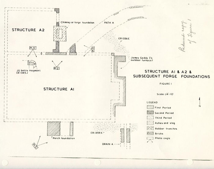 Figure 1
25
remained of the extension was most of its east wall (a single rowlock course) and the southeast and northeast corners. The other annex evidence had been destroyed when a cellar and bulkhead were built as part of later construction on the site (page 30). The addition had a north/south measurement of 12'6" and, if its west wall was on line with the conjectured west extremity of the early structure, the east/west dimension would have been approximately 16'6". The northerly wing was later altered to permit a substantial chimney or forge (measuring about 4'3" x 3'7") to be inserted into the east wall. This last change could be considered to be Period Three.
Figure 1
25
remained of the extension was most of its east wall (a single rowlock course) and the southeast and northeast corners. The other annex evidence had been destroyed when a cellar and bulkhead were built as part of later construction on the site (page 30). The addition had a north/south measurement of 12'6" and, if its west wall was on line with the conjectured west extremity of the early structure, the east/west dimension would have been approximately 16'6". The northerly wing was later altered to permit a substantial chimney or forge (measuring about 4'3" x 3'7") to be inserted into the east wall. This last change could be considered to be Period Three.
As pointed out on page 5, James Geddy I occupied Lot 161 prior to purchasing the adjoining property (Lot 162) in 1738. The deed which finalized the transaction described Lot 162 as being next to the lot where "James Geddy now dwells ..."72 Since Geddy was advertising his wares as early as 1737, it could be assumed that he first used the early structure on Lot 161 as a combined living area, workshop, and display room. If the building had been utilized in that way, the unused space must have been minimal, especially since, as Mr. Paul Buchanan has pointed out, the 9" foundations could only support a one and one-half story structure. Perhaps it was these crowded conditions that forced Geddy into purchasing the adjoining real estate.
26It would seem probable that, after acquiring Lot 162, Geddy and his family maintained their residence on that property while continuing to use Lot 161 as the industrial area. The huge quantities of iron and brassworking waste found north and east of the existing Geddy structure, along with that discovered beside Duke of Gloucester Street, would help substantiate this theory. Additional material pertaining to the industrial aspects of Lot 161 can be found on page 83. It will suffice to note that the evidence indicates the presence of a substantial gunsmithing and brass founding operation on the site in the period beginning around 1740 and continuing for an uncertain number of years thereafter, perhaps into the 1760's.
It would seem reasonable to conclude that after 1738 the James Geddy I building served as a gun shop and working area. Both the west room, with its possible forge, and the northerly extension may have been the workshops. Strata, adjacent to the north wing, containing metalworking slag and artifacts dating c.1740, would point to this conclusion. The east room, with its fireplace, may have been Geddy's shop, although no substantiating evidence was forthcoming.
Structure B1
Dating evidence for the construction of the earlier foundations of the extant main building was not found, however, it could be conjectured that the brickwork 27 was laid prior to 1750. Anne Geddy, the widow of James Geddy, Sr., sold Lot 162 to James Taylor in 1750 and, if earlier theories were correct, the living quarters were transferred to Taylor while the industrial area was maintained by Mrs. Geddy. This transaction would make little sense if it were not for the fact that Anne had moved to James City County by 1750 (page 11). Even though she had no reason to construct a living area for herself, it seems likely that, before 1750, Anne had erected a building on Lot 161 for her sons David and William. Thus, it can be theorized that most of the existing main structure's plan and foundations were built for Mrs. Geddy around c.1750.
The principal structure had an east/west main block which measured 53'0" in length and 16'0" in width. (Figure 2) Attached to its west room was a northerly wing with dimensions of 25'3" x 16'3". The appendage initially had no basement, while the main block had a cellar whose access was through a bulkhead of which nothing survived but the interior jambs. This entrance had been built into the north foundation approximately 10'0" east of the building's north wing. The basement floor had been lowered in 1930 to facilitate its space being used for the placement of modern mechanical equipment, such as boilers, electrical panels, etc. Consequently only minimal archaeology work was undertaken in the main block's cellar in 1967, but it was determined
 Figure 2
28
that the main cellar was part of the original construction plan by an examination of the exterior brickwork.
Figure 2
28
that the main cellar was part of the original construction plan by an examination of the exterior brickwork.
The footings for the north wing extended over the basement's foundation's northwest corner at first suggesting that the cellar was of one period and the northerly appendage and the basement's upper courses were of another (Figure 3). However, an examination of the southeast corner of the same cellar and of the main building's foundation extending eastward from it, revealed an identical structural relationship to that at the northwest. Thus, there can be no doubt that the foundations of the cellar, north wing, and the east room are of the same period. As mentioned on page 27, it was deduced that Anne Geddy was responsible for the construction of these foundations and that the brickwork was laid (c.1750), prior to the sale of Lot 162.
If the above theory can be accepted, the early James Geddy I period structure had been dismantled before 1750. However, the interior fireplace, which had been situated in the east room of the earlier A1 building (see page 24) apparently was retained to provide heat for the central of the mid-eighteenth century B1 structure. The room of the fireplace was not equipped with a heat source so it could be conjectured that it was initially used for storage or a shop at least during the winter months. The room's close proximity to the brassfounding shop helps substantiate this theory. (Figure 18)
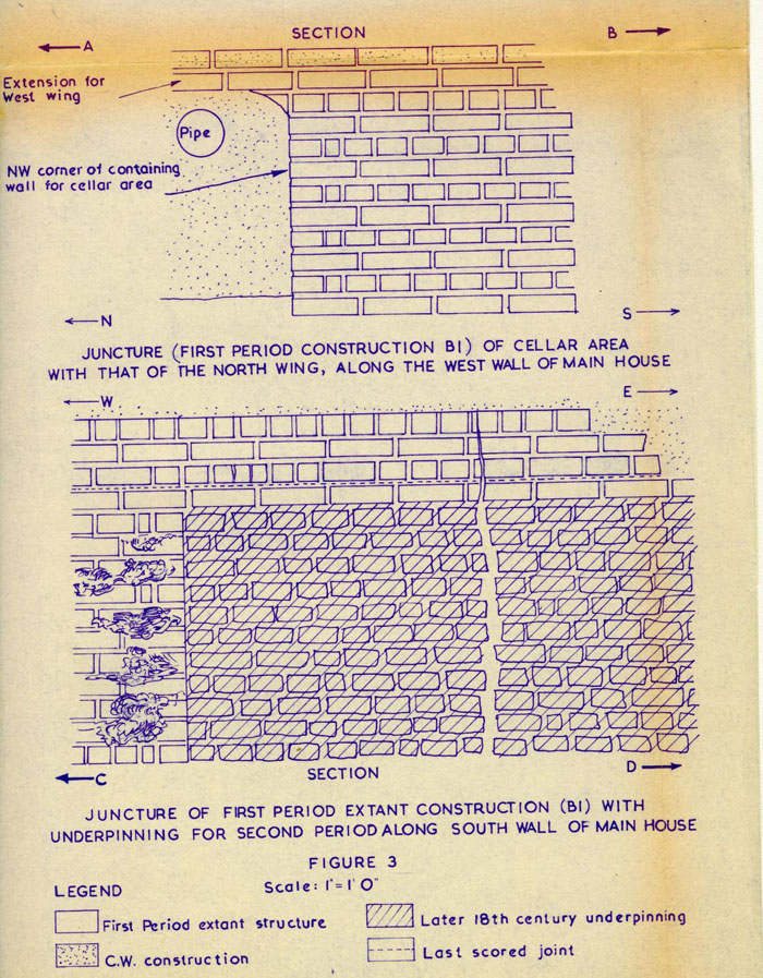 Figure 3
An examination of the house's south wall showed that the foundation for the room, adjoining the east tenement, had been underpinned. (Figure 3 and Plate VI) No doubt, this work was undertaken so that a basement could be added to that section of the building, and the presence of shell mortar would indicate that the bricks were laid in the eighteenth century. The interior of this cellar was not excavated in 1967 since its floor level had been lowered in 1953 during the reconstruction of the eastern portion of the main house. It was theorized that the basement's construction could have been part of the refurbishment activity on the site around c.1770, but substantiating evidence was not forthcoming.
Another cellar, this one crudely constructed, was found beneath the north wing of the main house (Plate VII). The basement had been dug out within the area of the building without underpinning the foundations. Thus, the north and east walls rested on a sloping bank of clay broken only at the point at which the bulkhead entrance cut through it. Although the western portion was not excavated, it was assumed that the wing's west wall was similarly supported.
Nevertheless, water seepage may have caused the foundation-supporting banks to erode. This phenomenon was surmised due to the fact that, after the cellar was in use, two courses of underpinning were added to the east wall for 30 increased support. Even so, during the 1967 digging, rain water was found draining into the basement from beneath the underpinning, as it probably did in the late eighteenth century. This defect could well have threatened the stability of the bank-perched foundations and may have caused the cellar's abandonment.
The basement's bulkhead (Plate VIII) positioned close to the north end of the east wall, (Figure 4) was filled with brown loam and purple ashes, containing datable material of the c.1800-1810 period. This fact, along with the artifacts of comparable date found in the cellar's fill (E.R. 1345B-D), would indicate that the basement was abandoned during the early part of the nineteenth century. It should be noted that this cellar's filling date seemed to coincide with that of the north bulkhead (page 32) suggesting that all of the underground facilities were of no use to the occupants of Lot 161 after c.1810.
Unfortunately, the cellar's construction date could not be pin-pointed archaeologically. However, the fact that it was abandoned in the early part of the nineteenth century would seem to suggest that the basement was being utilized during the last quarter of the eighteenth century. It could be conjectured that the cellar was built around 1770—along with other. improvements that together comprised the new construction advertised by James Geddy II in 1777.
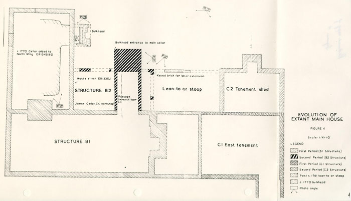 Figure 4
In the course of his architectural examination of the west face of the north extension Mr. Buchanan determined that a doorway probably existed in it, an extremely important discovery that tended to support the probability that Mrs. Neill rented that part of the building in 1777 when she advertised as being on Palace Street. (See page 18) Unfortunately, Mr. Buchanan's study was ordered stopped before he could be certain whether the door was contemporary with the construction of the framing or had been inserted at a later date. Archaeological attempts to locate traces of steps or a stoop approaching the doorway had been thwarted by earlier restoration underpinning and by the laying of utilities beside Palace Street.
Structure B2
Sometime after c.1755, the above mentioned B1 structure was extended northward. Actually when Colonial Williamsburg acquired Lot 161, the extant north wing was accompanied by another at the east.73 The resulting U was partially filled by a closed shed or lean-to across the central north face (see Plate IX). The east wing was of nineteenth-century date and was dismantled; the lean-to was assumed to be the same and it, too, was torn down. However, extant photographs of the latter's framing have since led Mr. Buchanan to conjecture that it may have been much older. The 1967 archaeological findings helped support that theory.
32The original northeast cornet (Plate X) of the lean-to was unearthed some 19'6" east of the main building's north wing and 10'0" north of that structure's north wall. A small portion of the addition's north wall was found overlaying the remains of the chimney which had cut through the east wall of the Geddy I north addition. The search for dating evidence for the lean-to's construction was impeded by the disturbance caused by the incursion of modern utilities. However, the artifacts, recovered from the small areas maintaining stratigraphy, indicated the lean-to could not have existed prior to c.1755.
The relationship of the lean-to extension to the main house's north wing could not be determined since modern underpinning destroyed any trace of a junction or abutment of the two foundations. However, it was discovered that the addition's outside wall developed in two stages. The first phase enclosed the bulkhead entrance to the main cellar enroute to its northeast corner. The east edge of the corner brickwork had been notched out for a subsequent second phase easterly extension (see page 36).
As mentioned above, the c.1750 main cellar's access was beneath the later north lean-to. Therefore, it was necessary to dismantle the original bulkhead steps and project the entrance northward as a passageway beneath the shed, at which point a new bulkhead entrance outside the lean-to was constructed (Plate XI). This feature was utilized 33 until the early part of the nineteenth century at which time it was abandoned and filled with miscellaneous rubbish including a partially used, inscribed sow of iron. After the fill (E.R. 1331F) had been inserted, a section of brickwork, representing part of the nineteenth-century underpinning for the lean-to, filled the space between the bulkhead walls. Evidence of the poorly installed nineteenth-century brickwork was also found overlapping the shed's colonial northeast corner.
It can be conjectured that the lean-to was built for use as James Geddy II's workshop. The only piece of waste silver found on the site was recovered from a stratum of washed sand and ashes (E.R. 1335J) inside the addition's walls. (Figure 4) The silver fragment, measuring less than 1" in length and about 1/8" in width, along with other small finds in the layer could have conceivably fallen through the cracks between the floorboards. The fact that in this same area parallel lines of straight pins were found would seem to add support to the conjecture. Even so, one piece of waste silver is not enough to prove that the northerly lean-to was used as James Geddy's workshop. However, a fragment of worked metal would not normally be found in or near a craftsman's home, whereas his finished pieces could very well have been.
If the lean-to had been used as Geddy's workshop, he probably would have had an annealing forge in that part of 34 the building. The fact that no evidence of a furnace was found in that area during the 1967 excavations might be used to refute the identification of the shed or lean-to as the silversmith's workshop. However, when Colonial Williamsburg acquired Lot 161, a photograph (Plate IX) of the north side of the house shows a chimney in the northerly lean-to, all evidence of which had vanished prior to the 1967 archaeological work. By the same token, it could be argued that the remains of Geddy's forge disappeared just as completely.
An article having some relevance in regard to the sizes of cutlers' and jewelers' forges was found in a magazine dated 1804. The following was part of a description of the house in London vacated by Nathaniel Bentley, Jr.:
"The second floor was a mere repository of rubbish and filth ... Adjoining this is a small antichamber, which was once his mother's favourite dressing room ... It has been since converted into a workshop, has in it the remains of a forge, workbench, tools for jewelry, smiths'-work, japanning, &c. It has shared the fate of the other rooms, lies neglected, and is nearly blocked up with filth and old iron.... "74
Apparently, all jewelers' and suchlike forges were not of massive construction and some were even situated on an upper floor. While Bentley was a cutler and jeweler, and not a silversmith, the reference helps support the contention 35 that a silversmith's forge on the first floor need not have left any evidence in the ground.
Structure C1
Unfortunately, due to Colonial Williamsburg's thorough construction methods, no dating evidence for the original "East Room or Tenement" could be found. However, the extant documentation (see page 13) would suggest that the east end of the building was in existence when James Geddy, Jr. acquired Lot 161 in 1760. This deduction was based on the fact that Geddy leased the tenement one month after purchasing the property and the rent agreement indicated that repairs were needed prior to the tenant's occupancy. Thus, since it seems unlikely that a wing built in August would be in need of repairs by September, it must be assumed that the tenement was erected before 1760.
Structure C2
The same lease agreement that gave the terminus ante quem for the building of the east end of the house also indicated that a shed addition was to be attached to the repaired east room. The new tenants, Hugh Walker and John Goode, were given permission to erect a "Room or Shed" with measurements of 16'0" x 10'0" and it was to have an outside chimney. It can be argued that the 10' depth was dictated by the depth of the already built Geddy workshop lean-to, in which case both additions may have been part 36 of the same architectural plan. (See below for supporting evidence) The date of construction for the tenement shed could not be determined archaeologically, but it would seem probable that the appendage was standing by c.1761.
It is conjectured that sometime after the tenement shed was added, the space between that feature and the Geddy lean-to was filled. As noted previously (page 32), the original northeast corner of the lean-to had been keyed to facilitate its bonding to an easterly extension; a fact which would suggest that the entire back was planned as one and consequently its components would, no doubt, have been erected near the same time even though they were built independently. Therefore, it would seem that a certain amount of symmetry was brought to the north side of the house after James Geddy II purchased the property in 1760.
Unfortunately only a small portion of the brickwork between the tenement shed and the Geddy lean-to survived and due to the disturbance caused by the reconstruction of the east end of the extant house, it was not possible to determine the relationship between the space-filling foundation and the west wall of the tenement shed. Likewise, it was impossible to ascertain if the brickwork served as a base for another section of closed shed or whether it was a foundation for a stoop. The latter would seem more logical since it would 37 have allowed easy access to the outbuildings from the main house, the tenement shed, and the Geddy lean-to. The fact that a brick walkway (Path C, page 62) was found heading toward the space between the two northerly appendages (tenement shed and the Geddy lean-to) would seem to support the theory that a porch could have connected the closed sheds.
It should be recalled that Geddy, in the lease agreement of 1760, gave Walker and Goode "free Use of the necessary house and Well75" on Lot 161. Consequently it would seem that an exit onto the back of the property would have been considered essential and therefore would probably have been included in the construction of the tenement shed. Since an outside chimney was centered on that addition's north wall, little space remained for a doorway, but if one had been inserted into that side of the shed, no evidence of it survived. On the other hand, if the back additions had been planned as one, a porch, with three doors opening onto it, between the tenement shed and the Geddy lean-to would have not only provided the needed access to the outbuildings, but also would have preserved the symmetry of the north side of the structure.
POSSIBLE REBUILDING OF THE GEDDY MAIN HOUSE
As previously mentioned (page 17), James Geddy II, in a 1777 notice, stated that all the buildings on the 38 property had been recently constructed. If his words can be taken literally, the main house must have been rebuilt around c.1770. This was strongly supported, if not confirmed, by the archaeological evidence. Although the main building's (B1) south cellar wall was constructed without an exterior builder's trench, a 2" to 3" space existed between the bank and the wall face. The gap had been filled with ashes and black soil and a sherd of creamware, dating after 1770, was found low in the deposit. Hence, James Geddy II may have rebuilt the structure prior to offering the property for sale. However, it should be noted that the 1967 archaeological work produced no evidence of a change in the architectural plan of building from that believed to have been erected for Anne Geddy in c. 1750.
THE OUTBUILDINGS
Structure D1 (Figure 5)
As previously mentioned, the curving path, which originated at the James Geddy I building's (A1) north door (page 24), followed a course which led toward the south entrance of another larger structure. The latter's foundations straddled Lots 161 and 162 and were probably erected by Samuel Cobbs, or at least by someone occupying both lots prior to James Geddy I's acquisition of the property. The building
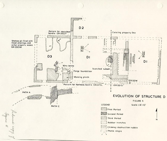 Figure 5
39
initially may have been a kitchen-laundry complex; however, substantiating evidence was not found.
Figure 5
39
initially may have been a kitchen-laundry complex; however, substantiating evidence was not found.
This dependency, supported by 9" foundations, measured approximately 30'2" x 16'0" and comprised two rooms on the ground floor. Evidence of the east room, extending some 16'6" onto Lot 162, had been found during the 1953 excavations of the Norton-Cole property. Fortunately, that archaeological investigation did not disturb the strata pertinent to the DI structure's evolution. The digging inside the room stopped when an early 19th century brick floor, presumably belonging to the dairy structure shown on the 1806 insurance plat,76 was uncovered.
The sloping subsoil made it necessary to fill areas before laying the original floor. This leveling deposit (E.R. 1385R) overlay a thin stratum of construction waste, i.e. mortar, brick flecks, etc. (Figure 6) The building's first clay floor (E.R. 1385P) overlay the graded surface.
The initial construction included the installation of a large, H-shaped chimney, whose central location enabled it to provide heat for both rooms (Figure 5). The main block of the chimney measured 9'6" x 8'0" and was constructed with orange, shell-mortared bricks averaging 8¾" x 4 3/8" x 2½" (Plate XII). The west fireplace had dimensions of 7'3" x 3'0" and its greatest heat concentration, discernible by the
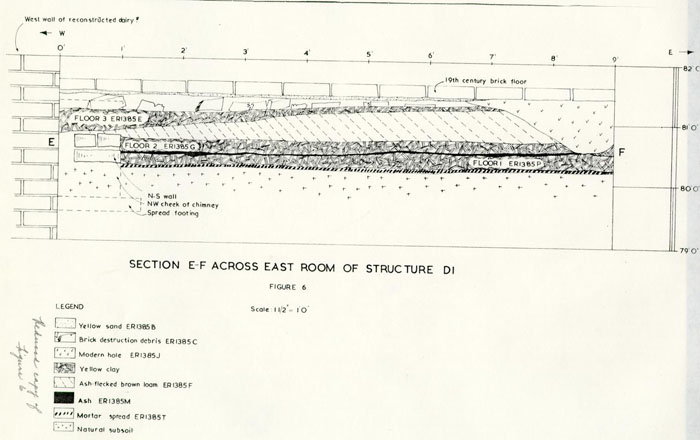 Figure 6
40
position of the scorched clay (Figure 5), was confined to an oval in the center measuring 2'9" x 2'8".
Figure 6
40
position of the scorched clay (Figure 5), was confined to an oval in the center measuring 2'9" x 2'8".
The fact that the brick hearth in the west room had been relaid no fewer than three times, would seem to indicate the fireplace was used extensively. However, according to Mr. Paul Buchanan, if andirons had not been used a brick hearth would not have lasted more than two or three years with normal employment. Obviously, each time the hearth level was elevated, the floor was raised. Initially, (Figure 7) the room's deck was paved with brick, but later, the flooring was made of hard-packed clay; the latter being relaid at least twice. Other than the floor level and the hearth being elevated from time to time, no major change in the west room's physical appearance or utilization could be discerned archaeologically. However, this was not the case in the east room. (see page 41)
Before discussing the alterations to the east room, it should be noted that a wooden beam had been inserted horizontally into the lower floor (Plate XIII). Its purpose probably was to prevent the original hearth's bricks from shifting. If that was the case, the timber's west edge would mark the east end of the brick hearth. The fact that brick bats, apparently laid, were found up to 1'3" east of the beam could mean either that the timber
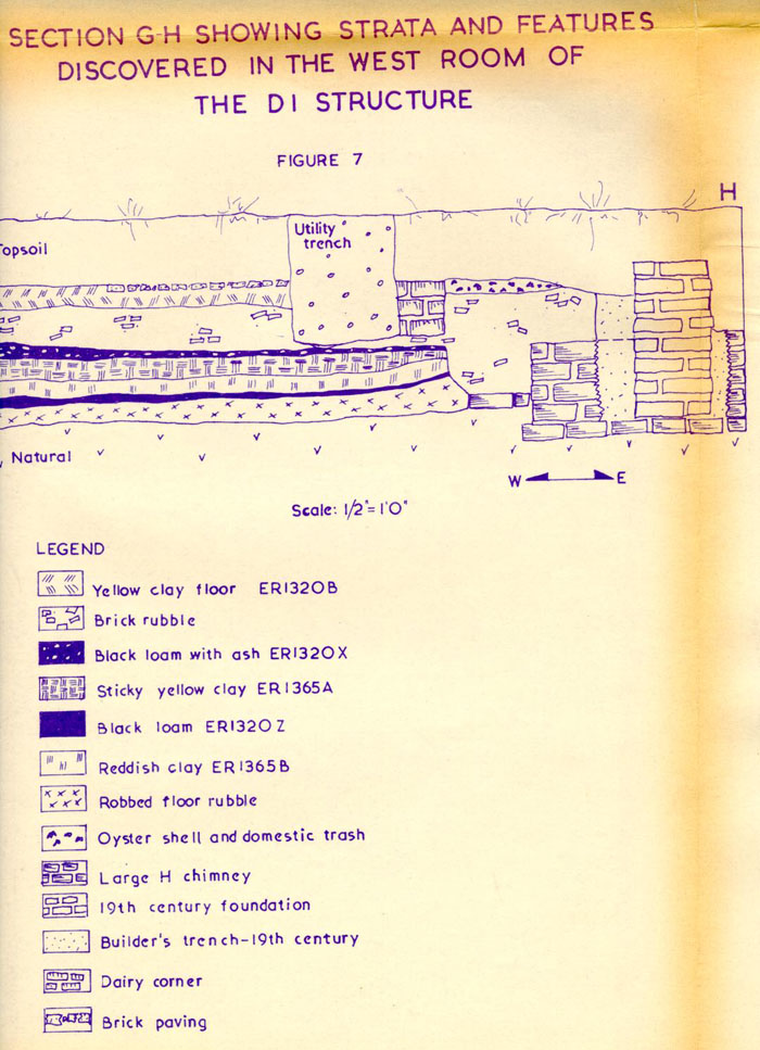 Figure 7
41
had been put in after the hearth bricks had started shifting or that the original flooring was of brick. The latter would seem more likely since the west room's first floor was of brick; (page 40) however, only that which is indicated on Figure 5 survived.
Figure 7
41
had been put in after the hearth bricks had started shifting or that the original flooring was of brick. The latter would seem more likely since the west room's first floor was of brick; (page 40) however, only that which is indicated on Figure 5 survived.
Another foundation, which apparently was part of the original construction plan, was found abutting the chimney on its north edge. The two surviving courses in the north/south wall were laid in sand rather than mortar. The purpose for such a foundation was not determined; however, it may be conjectured that it was part of a large oven, since a small section of a possibly corresponding wall was found in the west room (see Figure 5). If this interpretation is correct, there could have been no interior door connecting the two rooms.
The alterations to the east room began with the conversion of the open-hearthed fireplace to a forgelike foundation (Plate XIII). At the same time, the clay floor was relaid and this second pavement abutted the lower course of the in-filled fireplace. Small scraps of decayed brass were found pressed into this floor; a phenomenon which was also found in the building's west addition (page 44), in which brass-foundry work was proved to have been undertaken. Therefore, it could be conjectured that, prior to the sale of Lot 162 (1750), this east room was utilized as a foundry. Indeed, it would seem logical 42 that if a room being used for manufacturing purposes was sold, another would be constructed to take its place. The fact that a westerly extension, used for brass casting, was found during the 1967 excavations, suggests that the Geddy family did just that.
The new owner of Lot 162, and subsequent occupants of that property, apparently had no use for a forge. Therefore, it was partially dismantled leaving only the lower two courses of brick to serve as a hearth. This work having been accomplished, a third clay floor was laid so that the pavement would be elevated to the height of the hearth. It should be noted that a considerable amount of wear was present on the fore edges of the hearth's upper brick course (Plate XIII).
The north/south foundation, north of the chimney, (page 41) was being utilized during the existence of the forge. However, the above mentioned third clay floor sealed the brickwork's surviving courses, indicating that it was dismantled at the same time the forge was being torn down.
A thin layer of ash (E.R. 1385D) sealed the upper clay floor and overlying the cinders was found a thick stratum of destruction debris. The latter (E.R. 1385C) contained mortar, plaster, and brick fragments, along 43 with datable material indicating a deposition of c.1750-60, thereby suggesting a terminus post quem date for the demolition of the eastern part of the building. The stratum (E.R. 1321W), which indicated the destruction of the chimney, and the robber's trench for the west room's south wall (E.R. 1321S) contained datable artifacts which suggested a deposition of c. post 1750. Thus, both rooms may have been destroyed at the same time even though they were presumably not jointly owned.
Structure D2
Evidence of additions to the D1 building was found north and west of that structure. The remains of the northerly annex's northwest corner (Figure 5), west wall and sections of the north extremity were unearthed; however, datable material to indicate the construction period was not forthcoming. Brick bats were used in the foundation which extended the building's north/south dimension by 6'0".
Unfortunately, the addition's northeast corner was not located so it was not possible to determine if the extension spanned the length of the building. However, it seems possible that Well B (See Figure 18) cut through the east/west wall which, along with the disturbance caused by later construction work, could have eliminated all evidence of the northerly annex's northeast portion. It could be conjectured that the extension served as the access route between the east and west rooms, in which 44 case, it probably would have extended the length of the building.
Structure D3
As mentioned previously (page 42) a westerly addition to the DI outbuilding was located during the 1967 archaeological investigation (Figure 5). The extension's north/south dimension was 16'0" while its east/west measurement was 13'0". It was conjectured (pages 42-43) that this room was added when the eastern portion of building D1 was sold. Supporting evidence in the form of comparable elevations, helped reinforce the theory. The top of the second clay floor in the east room, which existed during the forge's utilization had an elevation of 80.88 while the bottom reading for the first floor in the west addition was 80.86. Thus, it would seem possible that the annex was erected around c.1750.
The first indication of the west extension's purpose was found while excavating in the northern portion of that room. Small droplets of brass or copper oxide were discovered on the floor and attached to the building's inner north wall. This would suggest that a crucible of molten metal had spilled against the wall and had sprayed out from it. Thus, it would seem that this part of the structure was used for founding operations. The numerous scraps of iron and brass trodden into the clay floor 45 substantiated this conjecture. However, irrefutable evidence of the annex's use as a foundry was discovered in the southeast portion of that room.
A solid brick foundation, measuring 2'6" x 2'2" was unearthed 2" north of the building's south wall (Plate XIV). Abutting the plinth to the north was a small forge with its iron grate in situ. The furnace had outside dimensions of 1'7" x 2' 4½" with an inner ash pit 10½" wide and 1' 7½" deep (Plate XV). The red bricks used in constructing the forge measured 8 3/8" x 4" x 2½" while those used in the plinth were orange and their average size was 8½" x 4" x 2½".
Wedged in the narrow space between the plinth and the shop's south wall (E.R. 1379L) was found a lead pattern for a harness buckle (Figure 5). This important find removed any doubt as to the forge's utilization. No doubt, sand casting flasks were prepared in the room and when the pattern was taken from the sand it was placed on the brick working plinth. At sometime during the remainder of the brass casting operation, the harness buckle pattern was accidentally raked off the table and, having fallen down a 2" wide crevice, was not retrieved.
As previously mentioned, the brass foundry had a dirt floor during the life of the small forge. However, the shop continued to be utilized after the furnace was dismantled, for a later brick floor was laid at the 46 elevation too high to afford access to the forge's ash pit (Plate XIV). A thin ash stratum (E.R. 1347G), beneath and predating the brick paving yielded artifacts dating c. post 1755. The furnace's ash channel bore artifacts dating in the same period, including a virtually complete wine bottle of c.1730. Thus, sometime after 1755, the forge was torn down and the brick floor laid. No indication of the shop's utilization, after the furnace's destruction, could be found. However, it appeared that a workbench or seat had stood against the west wall since the floor's reused bricks still retained scraps of mortar on their upper surfaces indicating that they had not been walked on continuously. The south end of the bench had been propped on bricks set on the floor.
It should be noted that two parallel N/S slots (Figure 5) were discovered in the north portion of the west extension. These shallow trenches, abutting the north wall and extending approximately 4'0" south of it, had cut through the shop's clay floor. The function of these slots could not be determined; however, it would seem possible that wooden beams, supporting a work bench, may have been placed in them.
The artifacts recovered from the fill indicated a deposition post c.1750. The eastern most trench (E.R. 1350F) contained iron and brassworking waste, along with a lead pattern for a sauce boat handle. The latter, the type 47 usually cast in silver, would suggest that silversmithing and brassfounding may have been undertaken at the same time on the Geddy property. Thus, the westerly addition may have been in existence while James Geddy, II, occupied Lot 161; however, it could be argued that if Samuel Galt leased a shop on the property around c.1750 the pattern could have been his.
At any rate, the brassworking shop was destroyed by c. 1770 since another building (page 52), overlaying the remains of the former's foundations, was constructed at that time. The fill, separating the bottom of the c.1770 outbuilding from the upper surface of the brassfounding shop's last brick floor, had an average thickness of 6", but inches of fill cannot indicate an accurate span of time, since a foot of dirt can be deposited by hand in a matter of a few minutes whereas the same depth could take nature several hundreds of years.
Structure E1 (Figure 8)
As stated on page 1, the 1930 archaeological endeavor exposed foundations believed to represent the remains of the early kitchen on Lot 161. The building was small, having measurements of about 12'0" x 16'0", and its walls were 9" thick. Foundations for a large, outside chimney were found at the eastern end of the building. The fireplace had dimensions of 4'6" x 10'0".
Structure E2
An addition to the kitchen was also
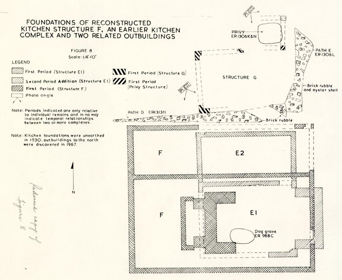 Figure 8
48
located in 1930. The northerly extension measured 16'0" x 8'6" and presumably was a lean-to, using the kitchen's north wall as its southern extremity. It could not be determined if the kitchen complex dated as early as James Geddy I's occupation of the property; however, it was surmised that the structure was torn down around 1770 when James Geddy II erected a second kitchen outbuilding.
Figure 8
48
located in 1930. The northerly extension measured 16'0" x 8'6" and presumably was a lean-to, using the kitchen's north wall as its southern extremity. It could not be determined if the kitchen complex dated as early as James Geddy I's occupation of the property; however, it was surmised that the structure was torn down around 1770 when James Geddy II erected a second kitchen outbuilding.
Structure F (Figure 8)
As mentioned on page 1, a second kitchen (if that was its purpose), had been discovered during the 1930 archaeological work and its foundations re-examined in 1966. During the latter excavation, it was found that the later kitchen's remains rested on at least ten inches of gray fill (E.R. 985A). From this stratum were recovered numerous fragments of early creamware which gave the building a terminus post quem date of circa 1770.
The surviving brickwork indicated the dependency had an east/west measurement of 30'0" and north/south walls 24'0" in length. Portions of the building's foundations had been destroyed either by the 1930 excavations or by the reconstruction of the first kitchen. However, the 1930 archaeological report indicated that all exterior walls were bonded and thus were erected at the same time.
An interior east/west wall was found about 7'2" from 49 the building's northern extremity. This partition bonded to the outbuilding's east wall but only abutted the structure's western limit. Mrs. Peachy Rogers, who remembered the building, stated that it only had "two rooms on the ground floor.77" Thus, if Mrs. Rogers' memory was correct, it would seem that this east/west interior brickwork eventually served, not as a wall, but as support for a wooden floor.
The Frenchman's Map of 1782 (?) (Figure 9) shows only one building to the rear of the main house and its position was approximately that of the 30'0" x 24'0" structure. The dependency was believed to have been a kitchen-laundry complex.
Humphrey Harwood's ledger showed an entry made May 15, 1778, which indicated repairs were made to Geddy's kitchen, laundry, and dairy. The 1967 excavation unearthed foundations which could readily be those of the dairy (see page 52); however, no separate laundry structure was discovered. It could be conjectured that structure F served both as a kitchen and laundry through, at least, some of its existence. This type of composite structure would not be without precedents for, in Williamsburg, during the eighteenth century, many kitchens had a space for cleaning clothing. The closest example of a kitchen/laundry complex was found next door on the Norton-Cole property.
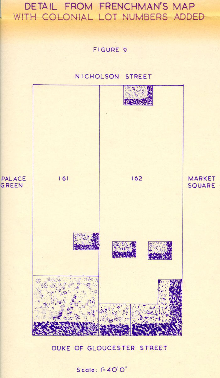 Figure 9
Structure F's large, central chimney foundation was re-studied during the minimal archaeological work in 1966. Most of the brickwork remained intact although the hearth and any dating evidence from beneath it had been dug out in 1930. Colonial strata did survive east of the H-shaped eastern hearth and, cutting into the natural subsoil, was found a dog grave (Figure 8). The burial cavity (E.R. 988C) passed beneath, and so predated the south/west cheek of the chimney. Unfortunately, no dating evidence was obtained for either the interment or for the construction of the fireplace.
During the 1930 archaeological work, a small 9" wall was found in front of the western fireplace and Mr. Ragland conjectured at that time that it was "built to hold fill to support the hearth.78" The wooden flooring could well have required some kind of underhearth and support for the joists beside it since Mrs. Rogers recalled that the building had "wood floors, which were 'springy'.79" It need only be said here that when the remains of the small retaining wall were re-examined in 1966, no evidence was found to refute Mr. Ragland's theory.
Structure G (Figure 8)
During the 1967 excavation, evidence of an outbuilding was found north of the first kitchen's lean-to (E2). Only two corners of the pier-supported 51 unit survived (Plate XVI), but these indicated the building had a north/south measurement of 10"4". The bricks used in the piers were rich red in color with average dimensions of 8½" x 3 7/8" x 2 7/8".
The structure's utilization could not be determined archaeologically nor could it be ascertained if it dated as early as James Geddy I's occupancy of the property. However, the fact that it was built along the same westerly line as the early kitchen (El) would suggest that the two structures were contemporaneous. A brick rubble walkway (see page 63), running east/west between the G and E structures, would support the conjecture. The path's position, south of structure G, would also suggest that access to the building may have been on its south side.
Structure H (Figure 10)
A smokehouse was discovered 8'6" west of the reconstructed kitchen and 11'6" north of the extant well. The building's central firebox was intact, but all of the exterior walls had been robbed out except for a small section of the western extremity (Plate XVII). The structure measured approximately 7'1" x 8'2 1/8" and its firebox's size was 2'3" x 2'2". The artifacts from the ashes in the firebox (E.R. 1356E) included fragments of creamware and tobacco pipe fragments, all indicating that the structure was in use after c. 1770. A brick walkway's (F) northern extremity ended near the center of the smokehouse's 52 south wall. Thus, access to the structure must have been from the south.
Structure J (Figure 11)
The remains of a small outbuilding measuring approximately 10'0" x 10'11" were unearthed about 11'10" from the main house's northeast shed addition (C2). The small building was believed to have been the dairy which Humphrey Harwood repaired in 1778 (pages 20 and 49.)
Unfortunately, the structure's builder's trenches contained no datable material; however, it could be conjectured that the dependency was erected around c.1770 when James Geddy II was making the improvements to his property. At any rate, if the theory as to the small building's utilization was correct, the brickwork had to have been laid prior to 1778.
Privy (Figure 8)
Evidence of a "necessary house", having conjectured measurements of 5'6" x 5'0", was found approximately 12'2" north of the reconstructed kitchen. The privy's pit had an east/west measurement of 3'11" and a north/south dimension of 3'0" (Plate XVIII). Its fill (E.R. 1306K and N) contained artifacts dating circa 1780, thus suggesting a terminus post quem for the privy's abandonment.
The building's southeast pier remained in situ while only brick fragments marked the northeast corner's location. No trace of the other two piers could be found. However, on
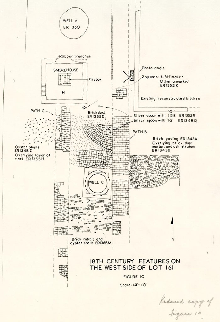 Figure 10 - 18th Century Features of West Side of Lot 161
53
the assumption that the pit was near the center of the structure, the western extremity was estimated to be about 5'0" from that of the east.
Figure 10 - 18th Century Features of West Side of Lot 161
53
the assumption that the pit was near the center of the structure, the western extremity was estimated to be about 5'0" from that of the east.
A walkway (Path E), surviving as brick rubble and oyster shells (E.R. 1306L), was found curving outward from the east face of the privy and extending south-southwest. Hence, the location of the path would indicate an eastern access to the "necessary house". "It is interesting to note that the 'house of office' faced east thus providing a modicum of privacy for those found seated when the door was inadvertently opened.80"
Outdoor Furnace (Figure 10)
What were considered to be remains of a freestanding forge was found 3'6" southeast of the reconstructed kitchen. The furnace's substantial foundations, having 13" walls except for a 4" one on the west extremity, measured approximately 5'8" x 5'6" (Plate XIX). The fact that only a half-brick width was present in the west end would indicate the smithy worked from that direction.
The forge's ash channel was approximately 2'3" x 4'0" and, as would be expected, it was filled with layers of forge-fuel remains. Unfortunately, these ash strata contained few datable artifacts but those recovered only indicated the furnace was being used after mid-eighteenth century. The artifacts recovered from the south wall builder's trench (E.R. 1322E) suggested a construction 54 date of c. post 1760; however, since that feature cut through strata of the same date, the forge could have been built much later. At any rate, it was theorized that this furnace was being used during the Revolutionary War period, at which time a great deal of industrial activity was taking place on Lot 161.
has been pointed out by Mr. William deMatteo that a silversmith would have little use for an exterior forge. An iron or brass worker, on the other hand, could have used one exclusively. However, since only iron fragments were found within the surrounding ash strata, it was conjectured that the forge was used for gunsmithing or general blacksmithing.
WELLS
Well A (Figure 10)
A well shaft, some 27'2" deep and approximately 5'0" in diameter, was discovered west of the newly reconstructed kitchen and north of the unearthed smokehouse foundations. The well's position would have also been west of the earlier range of buildings with which it probably was associated. It was conjectured that, Well A was the earliest of the three examined in 1967.
In 1750 when Anne Geddy sold Lot 162, she gave James Taylor one half of the well on Lot 161 along with perpetual access to it. Obviously the water supply was clearly on Lot 161 and since Well A was the only one found that was
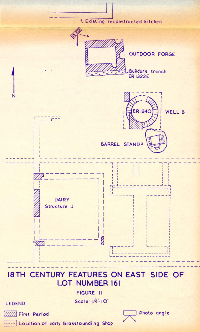 Figure 11 - 18th Century Features of East Side of Lot 161
55
definitely on Lot 161 and was of an early enough date, Mrs. Geddy must have been referring to it.
Figure 11 - 18th Century Features of East Side of Lot 161
55
definitely on Lot 161 and was of an early enough date, Mrs. Geddy must have been referring to it.
The brick lining had been totally removed, no doubt, for use in a new well and the abandoned shaft was filled almost entirely with the clay from the new one. The artifacts recovered from the upper strata suggested that the well was not in use after c.1765. It should be noted that a fragment of a delftware bowl, found in the upper layer of Well A's infill (E.R. 1360B) (Figure 12), mended with another found at a depth of approximately 13'0" (E.R. 1340M) in a well (B) positioned on the present property line between Lots 161 and 162. Thus, both wells were being filled at the same time; however, this would not mean that both were dug contemporaneously.
Only two objects of any consequence were found in Well A's lower levels and these at a depth of approximately 24'0". Positioned along the western edge of the shaft was a wooden-handled adze and a badly decayed iron spade blade. Portions of the latter's wooden handle were also recovered and subsequently restored. Since the implements were found in an area that may have been behind the well's brick lining, it could be argued that the tools were lost by either the workman who dug the well or the man who salvaged the bricks, rather than the crew that filled the shaft.
Well B (Figure 11)
The foundations for the wellhead and the upper lining courses of Well B had been uncovered
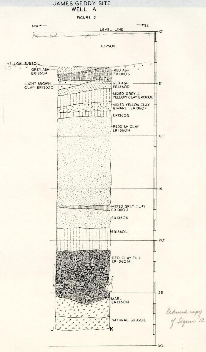 Figure 12 - Well A
56
by Mr. James Knight in 1953 and subsequently recorded on the unfinished drawing of that year's excavation discoveries.81 The surviving brickwork was positioned southeast of the reconstructed kitchen and apparently had cut through the north wall of the brassfounding building's north addition (D2).
Figure 12 - Well A
56
by Mr. James Knight in 1953 and subsequently recorded on the unfinished drawing of that year's excavation discoveries.81 The surviving brickwork was positioned southeast of the reconstructed kitchen and apparently had cut through the north wall of the brassfounding building's north addition (D2).
According to the 1953 architectural drawings, the well straddled the property line between Lots 161 and 162. Thus, it would seem that, if the lot line were correctly placed, the well was constructed when the two lots were jointly owned. This phenomenon did not occur between 1750 and 1782 and since the shaft was abandoned before the latter date (see page 58), it could be argued, in the absence of any other evidence, that the well dated earlier than 1750. However, there was other evidence and it did not support such a conclusion.
A single sherd from a Chinese porcelain saucer, found behind the brick lining at a depth of 25'3" (Figure 13), mended to a fragment found in a gray, ash-flecked clay layer (E.R. 1328R) north of the well. This last stratum contained datable material indicating a deposition post 1760. It would seem reasonable to suggest that the well was dug through that layer thus causing a fragment to drop down behind the lining. If this theory can be accepted, the water supply must have been first used after 1760. The fact that fragments of a "scratch blue" saltglaze tankard
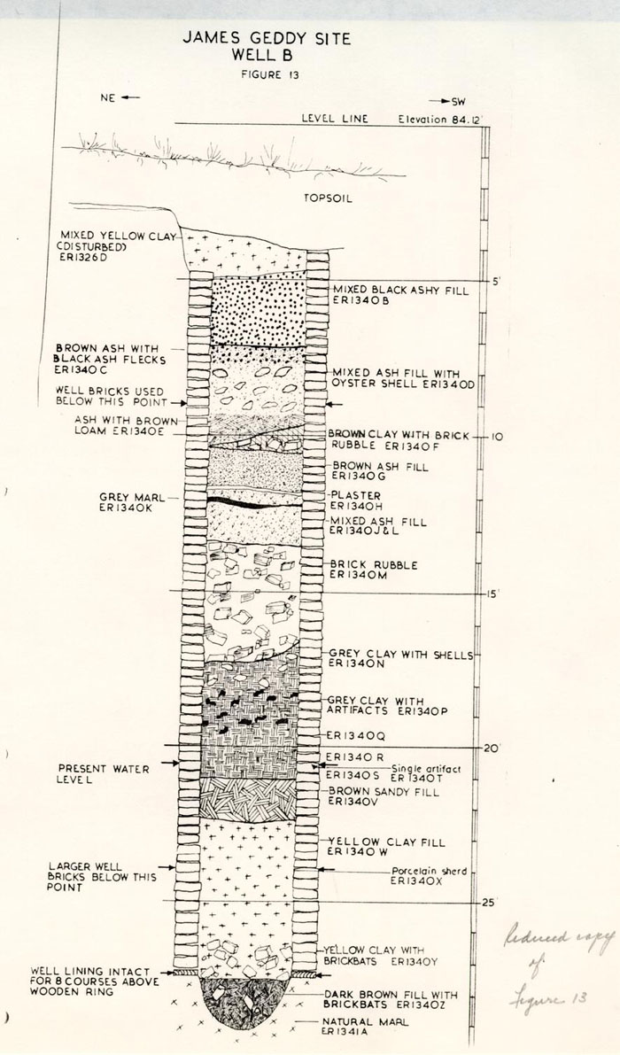 Figure 13 - Well B
57
dating after c.1750-60 were found in the shaft's primary fill would support such a conjecture.
Figure 13 - Well B
57
dating after c.1750-60 were found in the shaft's primary fill would support such a conjecture.
Hence, the well apparently did not straddle the property line and was constructed sometime after c.1760 on either Lot 161 or 162. It could be argued that the shaft was positioned on the former property; indeed, all of the archaeological evidence would point to that conclusion. The discarded rubbish, filling the well, included metallic slag, broken crucibles, watch glass fragments, and other items which could have been associated with the industrialized Lot 161. At least eleven ceramic fragments found in the well mended with other pieces recovered from post c.1760-70 features and/or strata on the Geddy property. These include the mend to the "scratch blue" tankard (see page 56) discovered in the well's primary fill. This many cross-mends would seem to more than suggest a relationship toward Lot 161. In addition, a mend was found between the delftware bowl [3788.E.R.1360 A-D-19B] recovered from the upper layers in Well A's fill and a stratum some 15'0" deep (E.R. 1340M) in the shaft of Well B. Therefore, it was deduced that when Well B was being filled the settlement in Well A's shaft necessitated its being topped up. Hence, if this theory is correct, both wells must have been on the same property and, since there is no question that Well A was on Lot 161, Well B must have also been on the Geddy property.
58The abandonment of Well B was caused by the collapse of a portion of the north lining wall (Plate XX). The shaft was thereupon filled with trash, including datable material discarded no earlier than c. 1765. This initial deposit eventually settled and was topped up in the early 19th century. Dating for these conclusions was based on the following factors: (1) no creamware present in levels below 10'5" (Figure 13); (2) fragments of a clouded ware teapot, unlikely to have reached Williamsburg before 1760, scattered through all levels from 10'5" to 22' 5½"; (3) and pieces of "melon" teapot, decorated with glazes not invented until 1760, found in levels from 19'4" to 22' 5 1½".
The bottom of the well was reached at a depth of 29'0" below the modern grade and only eight brick courses survived intact. These were salvaged, along with the well's waterlogged wooden ring, for use in future exhibits. The shaft's primary deposit (E.R. 1340Z) consisted almost entirely of brickbats and dark brown clay; however, a cat skeleton, two musket balls, a marble, the already mentioned "scratch blue" tankard fragments, and a sherd from a small German stoneware jug were recovered from the bottom of the well. Beneath the primary fill was found a hard-packed bed of marl (E.R. 1341A).
It should be noted that, what was considered to be a barrel stand was discovered southeast of Well B. A large 59 piece of stone, measuring 1'4" x 1'3½" x 2½", had been laid in clay and numerous brickbats flanked it on three sides (Figure 11). If this stone and brick platform was associated with Well B and if previous conjectures concerning that well's ownership are correct, the present property line between Lots 161 and 162 may be at least 5'6" too far west.
Well C
The 1930-31 excavations of Lot 161 exposed the remains of a well (Figure 10), some 12'0" southwest of the kitchen-laundry complex (F1). The shaft was subsequently dug to a depth of 22 feet and it was recorded that the well "was filled with trash and earth" and "part of the bucket was found in it". Unfortunately these facts did not suggest an abandonment date, consequently, we must be content to accept the record's conclusion that the well "was filled in at some distant date.82" It should be noted, however, that an examination of the exterior brickwork in the wellhead disclosed that repairs had been made to the foundation during the 19th century. Thus, the well's abandonment apparently was much later than that of the two shafts excavated in 1967.
It could be argued that Well C was built while Well A was being stripped and that that occurred after Well B's lining collapsed. At any rate, a brick dust stratum (E.R. 1355P), which predated the construction of Wellhead C, contained artifacts of the 1755-60 period. However, 60 included in the objects found in a lower layer (E.R. 1355R) was a single sherd of creamware, which, if not an intrusive fragment, would suggest that the well's construction was sometime after c.1770. Even though the date for the digging of Well C could not be pin-pointed, it was conjectured, from the factors mentioned above, that this shaft was later than either of those (A and B) excavated in 1967 and that it probably was in existence during the latter years of James Geddy II's occupation of Lot 161.
WALKWAYS AND YARD METALLING
Evidence of numerous paths and yard levels was found on Lot 161 in 1967 and each walkway can be found on the site's master plan (Figure 18).
Path A
As previously mentioned (pages 24 and 38), the remains of a curving brick walkway were uncovered in 1967 and it apparently had been constructed to connect the early main house (A1) with a dependency (DI-2). Much of the path's length had been destroyed, largely by the incursion of numerous modern utilities north of the house; however, the path's western extremity and a section south of the outbuilding survived. The elevation of the bottom of the west end of the walk was 79.46 while that of a portion some 24'0" northeast of the above point, was comparable at 79.55.
The fact that the path, whose average width was 3'6", 61 was utilized as a route between the two earliest buildings found on the site would suggest that the walkway was put down shortly after the initial layout of Lot 161. The stratum of sandy gray clay (E.R. 1377J), which predated the path, contained datable artifacts which would support such a conjecture. Among these were fragments of a wine bottle, a well-preserved latten rat-tailed spoon, pieces of delftware and a Silesian wine glass stem, all of which dated c.1720-1730.
Path B
The principal north/south route from the house to the back of the property was located some 2'0" west of the reconstructed second kitchen structure. The paving was not pursued to its northern limit; however, it was conjectured that the walk may have led to the stable (?) shown on the Frenchman's Map (Figure 9). Portions of the upper brick path had been located in 1930 and subsequently recorded on the archaeological map of those excavations.
The surface of the main walkway had been either repaired or relaid no fewer than four times (Figure 14). Initially the path was of marl with an average thickness of about 2" and width of 3'0". No artifacts were found in the firmly-packed stratum; however, the layer of gray clay (E.R. 1309V), which predated the marl stratum, contained material dating c.1740. Thus, the terminus post quem for the laying of the first north/south path was around 1740. Another walkway, with artifacts dating c.1755, overlay the marl which suggested
Section Figure 14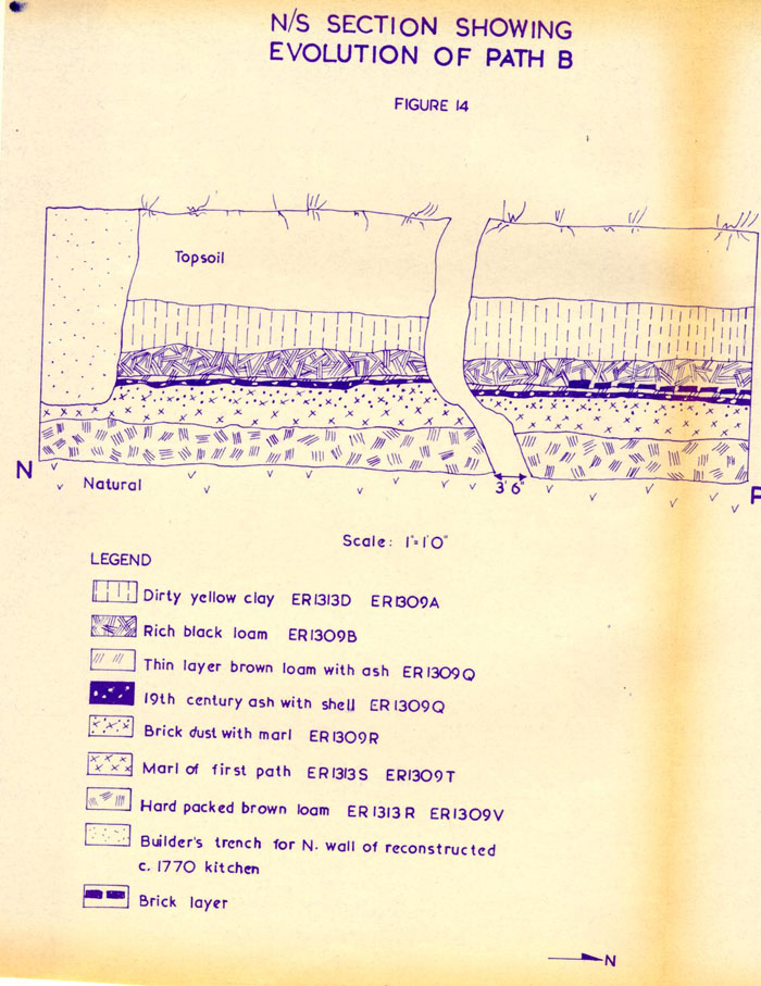 Figure 14 - N/S Section Showing Evolution of Path B
The second pavement (E.R. 1309R) was, no doubt, initially made of brick although all that survived was brick dust and occasional pieces of marl from the lower path. It would seem probable that this walkway existed throughout James Geddy II's occupation of Lot 161 since the stratum (E.R. 1309Q) which sealed the paving dated c.1840. The layer that sealed the second path was a combination of crushed shell and ashes and it served either as the third pavement or as a solid bed forth laying of the fourth walkway. The latter path was of brick and it was in existence after c.1840.
Path C
A small section of a brick walk was unearthed south of the D1-3 outbuilding. The main portion of the path apparently was extending toward that structure's west addition while a subsidiary pavement was advancing eastward, perhaps to the room adjoining the westerly extension. No doubt, the walks were connecting the main house (B) with the dependency (see page 37); however, modern utility trenches and reconstruction activity had removed all evidence of the path's southern extremity.
Unfortunately, the stratum of yellow clay (E.R. 1344L) which predated the paving contained no datable material. However, a layer of brown loam mixed with ashes and metallic slag (E.R. 1334K) abutted the path and the artifacts recovered suggested the walk was being utilized around 1750. It could be conjectured that the paving was laid at the same time 63 the post 1750 brassfoundry (D3, west addition to D1 structure) was constructed.
Path D (Figure 8)
As noted on page 51, a brick rubble walkway was found immediately south of the outbuilding (G) which suggested that the access to that structure may have been on its south side. The fact that the path was cut through by the construction of the c.1770 kitchen's (F) northwest section would seem to support the conjecture (page 51) that the pier-supported building (G) pre-dated the later kitchen (F) and possibly was contemporaneous with the early kitchen structure (El-2).
A small portion of the path's western extremity survived, and that section overlay the earliest north/south marl walkway (page 61). Thus, since the marl path was abandoned around c.1755, the brick rubble paving was laid sometime after that date. The latter contained fragments of white saltglaze and pieces of a late "scratch blue" bowl which would suggest that the walk was in use around 1765-70 or until the James Geddy II kitchen-laundry was built.
As the path neared the existing property line between Lots 161 and 162, it turned northward, presumably en route to the stable (?) shown on the Frenchman's Map detail (Figure 9). Even though much of the path was abandoned when the later kitchen (F) was built, the north/south portion continued in use and subsequently was repaired (see below).
Path E (Figure 8)
A walkway (E.R. 1307L), surviving as brick rubble and oyster shells, was found curving outward from the east face of the privy (page 53). This path was merely a relaying of the southeast portion of the above mentioned walkway and no doubt the repairs were made when the privy was built. The restored paving apparently terminated some 2'0" west of the c.1770 kitchen's northeast corner. Thus, the path's location not only indicated an eastern access to the "necessary house", but it also provided evidence for a doorway in the kitchen's north wall.
It would seem logical that the paving was abandoned around 1780 when the privy's pit was filled. However, the artifacts recovered from the walkway included a sherd of transfer printed white ware, a piece which could not date before 1820. Hence, if not an intrusive fragment, the presence of the sherd would suggest that the path continued in existence through the early part of the nineteenth century.
Path F (Figure 10)
The area north of the existing well apparently suffered considerably from erosion caused by rain shedding off the roof of the kitchen-laundry structure (F). Consequently, the brick walks and paving had been re-laid at least four times in that portion of the site. Only one path could be identified among the layers of brick and this ran north/south. The walkway's northern extremity 65 ended near the center of the smokehouse's (H) south wall (page 51). From that point, the pavement extended southward toward the extant Geddy House; however, due to modern disturbances, it was not possible to determine where, or if they met.
The north/south walkway had been relaid twice; however, the dating evidence would suggest that the life span of the path was relatively short. The initial paving was predated by a stratum of yellow sand and clay (E.R. 1355M) whose artifacts indicated a post 1770 terminus post quem date. The layer which sealed the upper brick walk contained material which suggested a deposition of c. post 1780. Hence, both paths were apparently constructed and abandoned within a ten-year span.
The first walkway was constructed almost entirely of well bricks. The fact that they showed little wear would indicate not only that the path was infrequently used but also that the upper brick paving was added for some reason other than the initial one's dilapidation. It could be conjectured that the erosion problem (page 64) contributed to the need for the repair.
Path G
The 1967 excavations produced evidence that numerous walkways had been laid between the main house's southwest portion and the Duke of Gloucester Street. The earlier paths may have been merely packed clay, however, due 66 to the difficulty in discerning a walk from a yard level when both are of clay, this theory could not be proved. At any rate, the first distinguishable paving (Figure 15) (E.R. 1367Y) was made of burnt shell and brick fragments. Artifacts recovered from the path, along with those from the stratum sealed by it, indicated that the walkway was being utilized after c.1760. Consequently, James Geddy, II may have been responsible for its existence.
Unfortunately, the yellow clay stratum (E.R. 1367T), which overlay the above mentioned path, was void of artifacts. Hence, it was not possible to determine an approximate abandonment date for the paving. However, a layer of gray clay (E.R. 1367S), which passed above the barren stratum, contained material suggesting a c.1820 deposition. Thus, the shell and brick pavement, laid around 1760, was no longer in use by 1820.
Subsequent paths were in existence during the nineteenth century. One made of burnt brick was laid after c.1820 and another thick marl walk was being used after c.1830. The most recent paving, discounting the Colonial Williamsburg brick one, was made of coal cinders sometime after c.1850.
Yard Levels
Apparently the appearance of Lot 161 during most of the eighteenth century was not as picturesque
Section QR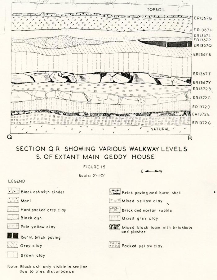 Figure 15 - Section Q R Showing Various Walkway Levels S. of Extant Main Geddy House
Support for a portion of this last theory was found in a stratum of mixed ashes and clinker (E.R. 1327M), which layer spread over the ground northwest of the brassfounding shop (D3), and contained datable material of the period post 1750-55, including one of the most important finds recovered from the site. The object was a small cabinet or box latch, made of brass, with the maker's mark (DG) stamped on the back. The hook's presence in the industrial waste would seem to indicate that David Geddy was responsible for some of the metallic scraps and sprue discarded after c.1755. It should be noted that another brass latch, also marked DG, was recovered from the stratum (E.R. 1327L) overlaying the above mentioned metallic refuse.
All this evidence points to a substantial gunsmithing 68 and brassfounding operation, with its inevitable debris strewn about the property, from c.1740 to 1755, and possibly later. The work would appear to have ceased or to have been very considerably reduced by 1760 since the strata which were associated with James Geddy II did not contain indications of subsequent brassworking. Indeed, from the archaeological evidence, it would seem that after 1760 an attempt was made to give the property a more presentable appearance. This was achieved by laying new and repairing old walkways, constructing proper drains (page 72) and improving the yard work areas.
The first paving (E.R. 1355P), southwest of the second kitchen and east of path G (Figure 10), was in existence around c.1760—65. It survived only as brick dust, however, the initial construction was probably much more substantial. As mentioned on page 64, this area sustained considerable erosion damage and consequently the brick pavement was relaid at least four times from c.1760 to c.1780.
The section of yard, west of path G (Figure 10), apparently had never been paved with brick. However, a layer of oyster shells (E.R. 1348Z), presumably a yard level, had been spread there after c.1755-60. A later stratum of tightly-packed marl (E.R. 1355H) abutted the west edge of path G. Hence, during the walk's utilization (pages 64-65) the yard, west of it, was laid with marl.
69During the existence of the marl level, the area south of the extant well was covered with brick rubble and oyster shells (E.R. 1368M). The artifacts, recovered from the latter deposit, included a fragment of delftware which crossmended with another found in a sandy wash layer (E.R. 1339H) southeast of the kitchen (F) structure. The presence of creamware in both strata would indicate a post 1770 date of deposition for each. The important crossmend suggested that when the area south of the extant well (C) was paved, the eastern portion of the property was not. However, a brick rubble spread (E.R. 1339G) sealed the sandy layer (E.R. 1339H) and thus, it would seem possible that the crossmending fragment may have been pressed into the lower level, in which case, the east and west parts of the property could have been paved contemporaneously, i.e., around 1770.
Additional paving (E.R. 1343A) was encountered near the center of Lot 161 (Figure 10), between the F kitchen and main structure. The burned orange brick overlay a stratum of brick dust, mortar and red ashes (E.R. 1343B). The latter's artifacts indicated a deposition of post c.1760-70 and thus suggested the terminus post quem for the pavement's construction. The datable fragments between the bricks indicated that the paving was not abandoned until sometime after c.1785.
The above archaeological evidence apparently indicates 70 that during the late eighteenth century, some type of paving existed between the east and west property lines and from the kitchen to some point southward. Unfortunately, due to modern utility and reconstruction disturbance, it was not possible to determine if the pavements extended to the main house; however, it could be argued that the logical southern limit was that building's northerly lean-to.
As noted on page 68, the property's appearance apparently was improved when James Geddy II acquired the land. However, the archaeological evidence would indicate that, during the Revolutionary War years, Lot 161 lapsed into something akin to the area's pre-1760 semblance. Large rubbish deposits were found immediately north of the main building's north wing (page 79), and a sizable pile of discarded iron gun parts, both civilian and military, was discovered west of the extant well (page 79). In addition to these pits, another large trash area (E.R. 13801 and K) was found crossing the west property line and extending toward Palace Street (Figure 17). The latter (page 78) contained industrial and household rubbish discarded after c. 1770. Hence, those passing the Geddy lot on Palace Street during the war years may have seen a flourishing industrial area, but not a well kept lawn or formal gardens.
THE DRAINS
Drain A (Figure 1)
The excavations, south of the 71 main building, unearthed a section of a north/south drain, which apparently was associated with the A1 structure. The bricks had been sealed by a stratum of brown sandy clay (E.R. 1359N) whose artifacts suggested a deposition after c.1740. Hence, the drain was probably abandoned before c.1750 and consequently was being utilized during James Geddy I's occupation of the property. The fact that the c.1750 main building seemingly cut through the brick-lined trough would support such a conjecture.
Drain B (Figure 16)
Another drain was discovered southwest of the outdoor forge and directly beneath a large paper mulberry tree. Unfortunately, root disturbance and subsequent construction trenches eliminated any evidence of the drain's origin. The fact that the drain had been cut through by a rubbish pit (E.R. 987M), whose artifacts dated after c.1750 would indicate the terminus ante quem for the construction of the brick gutter. It was theorized that the trough could have been associated with the outbuilding (DI) since the bricks were laid so that the water would flow north/northwest. No doubt, as the drain proceeded northward, its course changed in order to prevent the water from entering the early kitchen structure (El-2).
Drains C & D (Figure 17)
The digging in the western portion of Lot 161 revealed two brick drains which originally
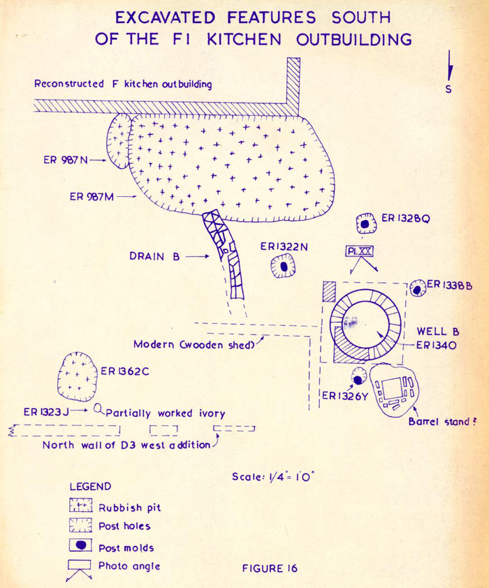 Figure 16. - Excavated Features South of the F1 Kitchen Outbuilding
72
may have been connected. One of them began at a point close to the extant well (C) and extended westward toward the Palace Green. Apparently, the feature was contemporary with the changes that occurred on the property after c.1770. This assumption was based primarily on the fact that the artifacts found between the bricks (E.R. 1353H) and those recovered from the stratum (E.R. 1353N), which predated the drain's construction, included creamware sherds.
Figure 16. - Excavated Features South of the F1 Kitchen Outbuilding
72
may have been connected. One of them began at a point close to the extant well (C) and extended westward toward the Palace Green. Apparently, the feature was contemporary with the changes that occurred on the property after c.1770. This assumption was based primarily on the fact that the artifacts found between the bricks (E.R. 1353H) and those recovered from the stratum (E.R. 1353N), which predated the drain's construction, included creamware sherds.
The east/west drain may have emptied into another unearthed outside the west property line. The latter, extending northeast to southwest, apparently decanted its water into Palace Street. Unfortunately, the area where the drains would have joined was disturbed by relatively modern post holes; however, the elevations of both channels could suggest a connection between them. The upper surface of the east/west drain's floor had an elevation of 79.82 as compared to a 79.60 reading on the corresponding part of the northeast to southwest trough. Hence, a 2.64 inch differential (approximately one brick course) existed in the drains' floor levels.
Ordinarily, this much variance might point to a disassociation between features; however, in this case, a relationship between these channels remains a possibility. The fact that no trace of mortar could be found on the upper surface of the east/west drain's one course walls would
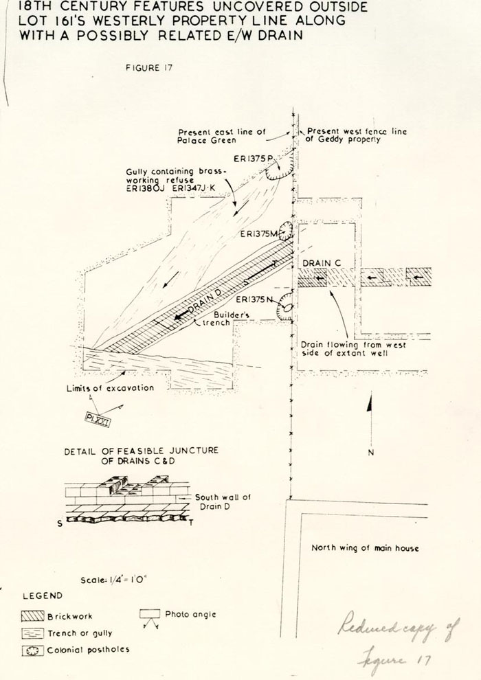 Figure 17 - 18th Century Features uncovered outside lot 161's westerly property line along with a possibly related E/W drain
73
suggest that they were no higher originally. However, portions of the northeast to southwest drain's walls were constructed two courses high (Plate XXI). Thus, if the drains were contemporaneous, the east/west channel's floor abutted the lower wall course of the northeast to southwest trough and the former's wall abutted the upper brick's in the latter's southern edge (Figure 17 detail).
Figure 17 - 18th Century Features uncovered outside lot 161's westerly property line along with a possibly related E/W drain
73
suggest that they were no higher originally. However, portions of the northeast to southwest drain's walls were constructed two courses high (Plate XXI). Thus, if the drains were contemporaneous, the east/west channel's floor abutted the lower wall course of the northeast to southwest trough and the former's wall abutted the upper brick's in the latter's southern edge (Figure 17 detail).
Another factor would suggest that the channels were being utilized simultaneously. Both had apparently been abandoned at the same time. The east/west drain had been filled with brown ashy loam (E.R. 1346C) whose recovered artifacts suggested a deposition of post c. 1825. The other trough was sealed by a stratum of dark brown soil (E.R. 1375C) which contained material dating after c. 1820. Hence, both drains were filled in around 1825 or later and consequently were probably used in conjunction with each other during the latter part of the eighteenth century and the first quarter of the nineteenth century.
FENCE LINES
Numerous post holes were found on Lot 161 during the 1967 excavations; however, their inter-relationships have not been totally ascertained due to the, as yet, incomplete study of the artifacts recovered from each feature. The absence of eighteenth century post holes on the eastern edge of the property could suggest that the lot 74 was not enclosed by a fence during the Geddy family's occupation. The limited digging outside the western boundary revealed three holes (Figure 17), running on a north/south line, which could have been part of the land's western property line fence. The holes had been dug and refilled sometime after c.1755; however, it was not possible to determine when the fence was abandoned since only one of the holes (E.R. 1375N) retained a recognizable post mold and it, unfortunately contained no datable artifacts.
A secondary fenceline (Figure 18), extending east/west, was found between the extant well (C) and the early kitchen structure (El-2). It was conjectured that this barrier may have joined the above mentioned north/south fence since the former's post holes contained artifacts dating in the same period (c. 1760) as those recovered from the latter's holes. Unfortunately, no crossmends were found to substantiate the theory, but it was apparent that the east/west fence was torn down around c. 1770.
The brick path (G) leading to the unearthed smokehouse foundations overlay the remains of the east/west barrier (Figure 18). Since the initial paving had been laid after c. 1770 (page 66), the secondary fence must have been dismantled prior to or as part of the c. 1770 changes which occurred on Lot 161. It would seem possible that the east/ 75 west barrier had originally turned northward and passed some 9'0" west of the first kitchen structure (E). This conjecture was based on the fact that no evidence of the fence was found north, south, or east of the post hole E.R. 1366Y (Figure 10). If that hole had been the position of a corner post and the barrier's route had changed to a northerly one, the lack of post holes north of E.R.1366Y could be explained readily. The construction of the c.1770 kitchen's west wall would have erased all evidence of the fence's return. If this theory can be accepted, it would support the c.1770 destruction date for the fence.
As mentioned on page 58, Well B had been abandoned after c.1765 when its north side collapsed. The break in the lining caused a subsidence of the natural clay north of the shaft. In order to prevent anyone from accidentally falling into the resulting depression or the well's shaft, a protective barrier seems to have been erected around the area. The encircling post holes (Figure 16) were spaced approximately 5'6" apart and contained artifacts dating after c.1755-60.
Sometime after c.1780-85, a north/south fence was erected north of the c.1770 kitchen. It apparently originated at the northwest corner of that structure and pursued a northerly course along the east edge of the main north/south path (B). The artifacts recovered from the stratum which 76 sealed the post holes (E.R. 1313K) indicated that the fence was not in existence after c.1820.
RUBBISH DEPOSITS
Large quantities of nineteenth and twentieth century domestic refuse were scattered all over the site; however, eighteenth century debris, both domestic and industrial, seemed to be just as plentiful and was far more informative. The trash, deposited during the Geddy family's occupation, was not only helpful in determining the household items in use, but the metallic waste added greatly to our knowledge of the crafts practiced on the site.
A rubbish pit (E.R. 1370C-E), probably filled by James Geddy I, was found north of the extant main building's north wing (Figure 18). The recovered artifacts, dating no later than c.1740, included brass and iron pieces; crucible fragments; ceramics such as dipped white saltglaze, delftware, and Chinese porcelain; and an intact wine bottle dating c.1730. Another pit (E.R. 1336H-J), filled by Geddy or someone who preceded him on the property, was discovered northeast of the earliest main building (A1). Unfortunately the area surrounding the refuse had been disturbed by recent reconstruction activity, but wine bottle fragments dating after c.1720 were retrieved from the surviving strata. (Figure 18)
77The most rewarding trash hole, found on Lot 161, was partially excavated in 1966 and completed in 1967. It was located in the vicinity of the southeast corner of the reconstructed c.1770 kitchen (Figure 16) and its artifacts suggested a deposition of c.1755-60. The rubbish included fragments of delftware bowls and plates, chamber pots of white salt glaze and delft, a Staffordshire slipware dish, a rare lead-glass pitcher and 28 complete or restorable wine bottles.
The assemblage also contained crucible fragments, brass and iron scraps, metallic slag, iron gun parts and brass kettle pieces. This group probably represented waste products from the gunsmithing and brassfounding business carried on by David and William Geddy.
An oval hole (E.R. 987N) measuring approximately 3'7" x 1'3", was found at the west end of the above pit (Figure 16). It was filled with washed sand and a large quantity of charcoal, the latter probably intended for use in the craftsman's forge. From the same deposit came an unfinished casting for a brass trigger plate which demonstrated that such parts were actually being manufactured, rather than merely assembled at the Geddy site in the mid-eighteenth century.
Sometime after c.1750, a deep hole (E.R. 1362C) was dug north of the D1 outbuilding's west addition (Figure 16) 78 for the apparent purpose of disposing of a sizable quantity of odorous pine tar. The pitch-like material had originally been kept in a wooden tub and parts of that container were recovered. The pit also contained window and bottle glass fragments, pieces of a delftware drug pot and saucer, bits of a crucible, two cannon balls and a feather.
An extension of digging, across the existing westerly fenceline toward Palace Green, revealed a late eighteenth century brick drain (page 71) which had cut through the filling of a shallow but wide depression (Figure 17). The artifacts recovered from the apparently natural gully (E.R. 1380J) included metallic waste and important copper alloy objects which may date from the David and William Geddy brassworking era.
The brass items found in the gully's fill included an unfinished buckle, part of a fine watch key and, most important of all, an elaborate but unfinished spandrel for a bracket or tall case clock. It was in the shape of a crown supported by two cherubs whose legs extended into a scroll ornament. (A consideration of the spandrel and its meaning was published in Antiques, Volume XCV, No. 1, January 1969, p. 110.) The presence of such an object left no doubt that the workmen on the Geddy property were capable of casting fine brass pieces.
Unfortunately, no clue was found to help identify 79 the maker of the brass clock parts found on Lot 161. By 1767, James Geddy, Jr. advertised that he repaired clocks, but this would not necessarily mean that he cast his own brass pieces. His brothers, David and William, or some other metal worker could have been making the parts.
Apparently a substantial amount of gunsmithing and general blacksmithing activity was undertaken on the Geddy property during the period c. 1770-1780. A large but shallow rubbish deposit (E.R. 1346J and E.R. 1374K and L), discovered southwest of the extant well (Figure 18), contained evidence to support such a conjecture. The artifacts, mostly discarded iron objects, included broken padlocks and keys, spikes, bridle bit fragments, hinge pieces and numerous gun parts.
The presence of many different sizes and types of gunlocks in association with other non-military iron would seem to indicate that scrap metal was being stockpiled for use in making weapons and other related paraphernalia for the colonial soldiers during the Revolution. The fact that an early dog lock (c. 1640) was found in the pit along with other dog lock pieces would suggest that outmoded firearms were being brought to the Geddy property to be converted to the contemporary flint lock mechanism.
Another Revolutionary Period rubbish deposit (E.R. 1369D and E) was discovered between the existing main 80 building's north wing and the iron-waste filled pit discussed above (Figure 18). The refuse must have been deposited after June, 1775, since sherds from Lord Dunmore's Chinese porcelain dinner service were among the many recovered artifacts. Also included were numerous Dutch tobacco pipe fragments and plain French faience pieces, both of which are extremely rare in Williamsburg excavations. The presence of these Dutch and French items would support the pit's post 1775 date since, during the middle years of the Revolution, English goods were not available. It should be noted that the 1775 date is merely a terminus post quem for the deposition and, consequently, the refuse could have been discarded by the French soldiers who were in Williamsburg by September, 1781.
ARCHITECTURAL EVIDENCE FOUND ON THE GEDDY SITE*
An archaeological investigation of a site often reveals architectural data unmentioned in extant documents. Unfortunately, the excavations can only expose that which has survived underground. Hence, the size and shape of a building may be determined and possibly an access route to it, but the number of windows or the slope of the roof obviously could not be ascertained archaeologically.
However, the recovered artifacts often give excellent clues to aid in reconstruction planning. For instance, almost 81 every site excavated in Williamsburg has produced evidence that at least some of the earlier buildings had casement type windows. The Geddy property was no exception since numerous "turned lead" fragments were recovered during the 1967 archaeological work. Many of these, from strata dating in the period c.1745-60, were found in the vicinity of the outbuildings D and E. Hence, it might be deduced that those structures initially were constructed with casement windows.
Fragments from at least four different blue and white delftware tiles were recovered from the Geddy property and these, from strata dating around the mid-eighteenth century, were found in areas immediately north and south of the main house. Thus, it could be conjectured that at least one mantle in the main structure was faced with these decorative tiles. Only one plain white piece was recovered and that from a modern hole. Evidence that manganese decorated tile was used on Lot 161 was also found; however, the fragments, belonging to at least five tiles of different ornamental design, were in contexts of from after 1775 to post 1820.
Eight pieces of clay roofing tile were retrieved from the Geddy site in 1967, all of which were the rectangular variety and orange in color. All but two of the eight fragments were found in strata dating c.1745-55 and were widely scattered throughout the site. The deposition date 82 could possibly indicate that the c. 1750 main house that Mrs. Geddy erected or the one which it replaced may have had a tile roof, but substantiating evidence was not forthcoming.
Only a minimal quantity of marble and stone was recovered from the Geddy property, and of these pieces two could have been utilized architecturally on Lot 161. Both were small, but they had edging similar to that which could have served as part of a mantel. One sizable fragment of shaped marble reused in Drain C, appeared to have been from a mantel, however, Mr. Buchanan believed it to be a base piece from a tombstone.
Many items of hardware were retrieved during the 1967 excavations, but a complete report on the better examples must be delayed until the objects can be properly treated in the laboratory. At this point it is enough to say that fragments of hinges, latches, pintles, locks and keys, along with many other iron objects which once were associated with the Lot 161 structures, were recovered.
THE ARTIFACTS (SUMMARY)
The 1966 and 1967 finds are to be the subject of the fifth publication in Colonial Williamsburg's archaeological series and will also, no doubt, figure in later publications on crafts practiced in Williamsburg during the eighteenth 83 century. For these reasons only the most important objects or fragments thereof are mentioned below.
Industrial Aspects of Lot 161
Many crafts were practiced on the Geddy site from before 1738 to the last part of the eighteenth century. The 1967 excavations unearthed the discarded products of gunsmiths, locksmiths, brassfounders, silversmiths, clockmakers (or repairers), and cutlers. Of these, the brass founding operation provided the greatest amount of archaeological evidence.
It seems curious that so much brass waste was recovered from Lot 161 since it was a simple operation to remelt the metal. The fact remains that numerous unfinished objects, spoiled castings, channel sprue and unused brass from crucibles were retrieved. At least 16 unfinished or spoiled buckle castings were found along with an uncompleted trunk handle part, a copper multiple rivet casting and a hollow mask which may have been intended as a pistol butt ornament. As mentioned on page 67, two of the most important finished brass objects found on the property were cabinet latches with the initials DG stamped on their shanks.
The recovery of lead patterns used in the sand casting technique identified some of the types of items which were 84 being manufactured on Lot 161. These included a musket side plate, a trigger guard, a weight, two sizes of harness buckles, and two other objects which are, as yet, unidentified. It should be noted that an earlier excavation of the Norton-Cole property (Lot 162) produced a lead pattern in the form of a miniature ship's anchor. Another smaller lead anchor was found during the 1965 archaeological work at the Wetherburn's Tavern site. Unfortunately, the Research Department's staff has been unable to find documentation to suggest a purpose for the replicas.
Other unfinished brass objects were recovered in 1967; however, they were associated with crafts that would also utilize the casting operation. Two of these rough objects were trigger plates, one for a musket and another for a pistol. A decorative pistol side plate, with its sprue still attached, was found south of the main house (E.R. 1359M). Many gun locks and firearm parts, made of iron, were retrieved and these included a forged cock which had been partially shaped with a hammer but had not been finished. The recovered gun locks, dating from c.1640 through the late eighteenth century, had been completed so it could not be proved that any were made on the Geddy property. The recovery of two unfinished iron keys suggest that locksmithing was practiced on the site. 85 Evidence was found that the clockmaking or at least watch repairing trade was practiced on the Geddy property. Many watch glass fragments were recovered along with four watch keys, one of which was unfinished. As noted on page 78, an unfinished spandrel for a clock was discovered as well as another one which had been trimmed leaving only the face of a cherub. The completed clock pieces retrieved in 1967 included a gathering pallet, a gear wheel, and a clock rack. These last three items were identified by Mr. Joseph Grace who is presently the clockmaker for Colonial Williamsburg. Many grinding stone fragments were discovered on the Geddy site and these were believed to have been related to the cutlery work undertaken on the property in the mid-eighteenth century. The recovery of a piece of sliced bone and a partially cut down ivory tusk could suggest that the craftsmen were making, or at least repairing handles. However, these items may have been intended for inlay work on gun stocks or clock cases. The piece of ivory had been dropped vertically down a small hole (E.R. 1323J), whose diameter was 6" and depth 9", (Figure 16), apparently as a child's prank.
A small number of sword parts were found; but as most of them were finished pieces, it could not be determined if they had been manufactured on Lot 161. However, an unfinished quillon block for a small sword was recovered; and it is 86 reasonable to conclude that it was cast on the Geddy property. It should be noted that another uncompleted quillon block, undoubtedly from the same mold as the Geddy example, was discovered in 1930 during excavations in the vicinity of the Governor's Palace.*
The silversmithing operation on the site left few traces; however, one piece of waste silver was recovered (page 33). As mentioned on page 46, a lead pattern for a sauce boat handle was found (E.R. 1350F) and, since it was the type usually cast in silver, the discarded piece could have been associated with the silversmithing craft. The most important evidence of that trade came from the silty wash overlaying the brick paving north of Well C.
In that deposit** were found four silver teaspoons, and a once repaired tablespoon (E.R. 1352R) owned by James Geddy, II. The latter had been engraved with the initials I 1G2 E (James and Elizabeth Geddy). The twelve presumably indicated that the spoon was one of a set of twelve. Unfortunately, the tablespoon bore no maker's touch mark so it was not possible to determine whether it was of Geddy's own making. Of the teaspoon assemblage, three had 87 been stamped with the manufacturer's initials. Two (E.R. 1348Q) bore the initials IG (James Geddy II) while the other was stamped with the BH mark of an, as yet, unidentified silversmith. This last spoon was engraved with the owner's initials (RS), but his or her name has not been determined. The same deposit (E.R. 1352K) that produced the BH-made spoon contained another that was unmarked.
The recovery of the Geddy-made spoons was of utmost importance since it is now possible to identify objects with that mark as Geddy's. In fact, the find has already proved that a spoon in Colonial Williamsburg's archaeological collections was made by him. During the excavations at the Governor's Palace in 1930, a silver teaspoon was found bearing the maker's mark (IG) and engraved with initials attributed to Christopher and Anne Ayscough.83 The spoon's touchmark had led to the conjecture that it may have been made by Geddy; however, this could not be substantiated until 1967, at which time, a comparison of the touchmarks suggested beyond reasonable doubt that the Ayscough spoon was manufactured by Geddy.
The Domestic Remains
Many of the important ceramic finds have already been mentioned throughout the report. 88 The Geddy property yielded something in excess of 100,000 pottery sherds during the 1966 and 1967 excavations. Some were plain; however, most of them had been decorated with patterns common to the eighteenth century. The majority of plates, bowls, cups, and saucers found were of white salt-glazed stoneware; but a sizable quantity of delftware, Chinese porcelain and creamware items were recovered. Numerous wine glass fragments were retrieved, as were tankard sherds of delftware, German stoneware and saltglaze. The greater portions of pitchers of Jackfield, Nottingham, and "scratch blue" stoneware were also found.
CONCLUSIONS
The Geddy House
The structure (A1) located archaeologically on Lot 161 had conjectural measurements of 20'0" x 32'6". It was built prior to 1738 and possibly as early as 1718. A northerly addition had been attached and later a forge-like foundation had been inserted into the extension's east wall.
The building had been replaced around c.1750 by one whose foundation plan resembled that of the extant house. 89 The second structure (B1) originally was L-shaped with the main east/west block measuring 53'0" in length and 16'0" in width and having a contemporary north wing with an east/west measurement of 16'0"; and if its north wall was reconstructed on the original foundation line, the wing had a north/south length of 24'0". This building had a basement beneath its east/west section; however, when a northerly lean-to (B2) was added to the house, the cellar's bulkhead entrance had been shifted northward.
Sometime prior to 1760, an east room or tenement (C1) had been added to the main house. By 1761, a shed (C2) had been attached to that tenement which resulted in the architectural plan of the main structure changing from an L-shaped to a U-shaped complex. The space between the B2 northerly lean-to and the C2 tenement shed was subsequently filled either by a closed shed or a stoop.
It would seem possible that the main (B1) structure had been totally or partially rebuilt around 1770; however, the 1967 excavations produced no evidence of a change in the architectural plan of the c.1750 house. Apparently, although irrefutable dating indications were not found, the below ground facilities had been expanded around 1770. 90 A crudely constructed basement had been dug out within the area of the (B1) building's north wing. This project had been accomplished initially without underpinning the foundations which meant that the walls rested on a sloping bank of clay. Water seepage may have caused these banks to erode since, after the cellar was in use, two courses of underpinning were added to the east wall for increased support. The bulkhead for the basement had been positioned close to the north end of the wing's east wall. Underpinning found beneath the room next to the east tenement, indicated that a cellar had been added to that part of the structure and it was surmised that the work may have been performed c.1770.
The Outbuildings
The earliest dependency (D1) found on the Geddy property had two sizable rooms with a large H-shaped chimney between them. The building straddled the property line between Lots 161 and 162 and this factor caused changes to the structure in 1750 when the lots were no longer jointly owned. Originally the dependency could have served as a combination kitchen-laundry, however, the east room had been converted to a foundry with the insertion of a forge into that room's fireplace. When Lot 162 was 91 sold, the foundry operation was moved into a newly constructed western addition (D3) and the east room's forge was dismantled and its base made into an open hearth.
The 1930 excavations on Lot 161 had uncovered foundations (El) believed to have represented the remains of a kitchen. Evidence was also found that the structure had been extended northward (E2). During the 1967 work, a pier-supported building (G) was discovered north of the E2 remains; and since both structures had been erected along the same westerly line, it was surmised that both were contemporaneous. At any rate, the walls of the two buildings had been dismantled prior to c. 1770.
Four new outbuildings appeared on Lot 161 around c. 1770. The above mentioned E2 structure had been replaced by a much larger one (F) believed to have been a kitchen-laundry complex. A dairy (J) and smokehouse (H) were erected, along with a privy and possibly an outdoor forge and Well C. Hence, the archaeological work undertaken in 1967 would appear to substantiate that James Geddy II greatly improved his property during the period c. 1770-77.
Footnotes
APPENDIX I
TABLE OF BRICK SIZES AND MORTAR COMPOSITION
Brick samples removed from the Geddy site.
| Location | Measurements | Color |
|---|---|---|
| A1 building's north wall (E.R. 131OZ) | 9 1/8" x 3 7/8" x 2 5/8" | orange |
| A2 northerly addition (E.R. 1384A) | 8½" x 3 7/8" x 2½" | salmon |
| Forge foundation cutting through A21s east wall (E.R. 1384B) | 8¾" x 4¼" x 2½" | orange |
| Northeast corner of B2's northerly lean-to (E.R. 131OX) | 8'4" x 4" x 3" | salmon |
| North bulkhead beneath B2's northerly lean-to (E.R. 1310R) | 7 5/8" x 3¾" x 2 5/8" | orange |
| Bulkhead in east wall of B1's northwest wing (E.R. 1310S) | 8 3/8" x 4" x 2 5/8" | dark red |
| D1 structure's west wall (E.R. 1384F) | 8½" x 4" x 2 3/8" | orange |
| D1's central chimney (E.R. 1384J) | 8 5/8" x 4" x 2½" | orange |
| D2's west wall (no sample) | 8½" x 4¼" x 2½" | orange |
| 98 | ||
| D building's east room forge (E.R. 1384K) | 8¾" x 4" x 2½" | orange |
| D3 structure's south wall (E.R. 1834D) | 8½" x 4" x 2½" | orange |
| D3's small forge (E.R. 1384C) | 8¼" x 4" x 2½" | orange |
| D3's working plinth (E.R. 1384E) | 8 3/8" x 3 7/8" x 2½" | orange |
| Pier-supported G building (1310B) | 8¼" x 3 7/8" x 2 5/8;" | orange |
| Smokehouse's (H) west wall (E.R. 1310Q) | 8 3/8" x 4 1/8 x 2 1/8" | dark red |
| H building's firebox (E.R. 1310P) | 8 3/8" x 4 1/8" x 2¼" | salmon |
| J structure's west wall (no sample) | 8½" x 4¼" x 2½" | dark red |
| Privy's southeast pier (E.R. 1310A) | 8½" x 4¼" x 2 5/8" | orange |
| Outdoor furnace (E.R. 1310F) | 8 3/8" x 4" x 2 3/8" | orange |
| Wellhead bricks (E.R. 1310D) | 8¼" x 4" x 2 7/8" | salmon |
| Well B's upper lining (E.R. 1310J) | 8¼" x (4" x 5½") x 2¾" | burnt orange |
| Well B's lower lining (E.R. 1310M) | 8 5/8" x (53/8" x 4¼") x 2¾" | orange |
| Barrel stand south/east of Well B (E.R. 1310H) | 8 5/8;" x 4 1/8" x 2 5/8" | orange |
| Drain A (E.R. 1384G) | 8½" x 4" x 2 3/8" | salmon |
| Drain B (E.R. 1310N) | 7" x (4 5/8" x 3 3/8") x 2½" 8 5/8" x 4 1/8" x 2 5/8" | salmon orange |
| Drain C (E.R. 131OW) | 8½" x 4¼" x 2½" | burnt orange |
| Drain D (E.R. 1384H) | 8 3/8" x 4" x 2½" | dark red |
Mortar samples removed from the Geddy site and preserved
| Location | Composition | Color |
|---|---|---|
| A1 building's north wall (E.R. 131OZ) | generally finely ground oystershell | buff |
| A2 northerly addition (E.R. 1384A) | medium composition, some limestone and charcoal | buff to gray |
| Forge foundation cutting through A21s east wall (E.R. 1384B) | fine but very hard, some limestone and charcoal fragments | buff |
| Northeast corner of B2's northerly lean-to (E.R. 131OX) | coarse, containing oystershell and deep buff | charcoal |
| Keying section of B2's northerly lean-to (E.R. 1310K) | medium composition, great deal of oyster- shells | gray |
| North bulkhead beneath B2's northerly lean-to (E.R. 1310R) | generally finely ground oystershell | buff |
| Bulkhead in east wall of B1's northwest wing (E.R. 1310S) | finely ground | buff to dark gray |
| D1 structure's south wall (E.R. 1384D) | fairly coarse, large oystershell fragments, some limestone and charcoal | gray |
| D1's central chimney (E.R. 1384J) | medium composition, some oystershell, limestone and charcoal | buff |
| D building's east room forge great (E.R. 1384K) | medium composition, deal of limestone and charcoal | gray |
| D3's small forge (E.R. 1384C) | medium composition, some oystershell, limestone and charcoal | buff |
| D3's working plinth (E.R. 1384E) | fairly fine, hard, some limestone and small oystershell fragments | dark buff |
| Pier-supported G building (E.R. 1310B) | medium composition, some limestone, charcoal and small pebbles | gray |
| Smokehouse's (H) west wall (E.R. 1310Q) | coarse, some limestone and oystershell | buff |
| H building's firebox (E.R. 1310P) | medium composition, limestone, charcoal, and oystershell | gray |
| Privy's southeast pier (E.R. 1310A) | fairly coarse, some oystershell | light to dark gray |
| Outdoor furnace (E.R. 1310F) | fairly fine composition | gray |
| Wellhead bricks (E.R. 1310D) | fairly fine composition, very little oystershell | gray |
| Drain B (E.R. 1310N) | fairly coarse, great deal of oystershell, some charcoal | buff |
| Drain C (E.R. 131OW) | coarse, some oyster- shell | buff |
| Drain D (E.R. 1384H) | medium composition, great deal of oyster- shell | buff |
APPENDIX II
|
Excavation Register (E.R.) Number | Description of Feature or Stratum |
|---|---|
| 985A | Gray flecked soil predating kitchen wall and sealed by C.W. disturbance, post c.1770. |
| 987M | Trash pit containing gray clay flecked with ashes, post c.1745-50. |
| 987N | Oval shaped hole cutting through the western portion of the above pit, post c.1750. |
| 988C | Grave filled with gray clay and ashes and containing a dog skeleton, no datable artifacts, sealed beneath southeast cheek of chimney for Structure F. |
| 1306K | Privy filled with dirty mixed clay and sealed by the 19th century black loam stratum E.R. 1306D, post c.1780. |
| 1306L | Brick and oyster shell path curving into privy from the east, post c.1820. |
| 1309F | Large and deep hole, located in the SW corner of IIID3, filled with mixed yellow clay and sealed by the dark brown loam E.R. 1309D. This hole cut through the marl patch in that area but predated the brick paving along west edge of area, post c.1780. |
| 103 | |
| 1309N | Post hole, located north of the hole E.R. 1309F, filled with mixed dark loam and cutting through the brick paving in the west section of IIID3, post c.1785. |
| 1309Q | Thin stratum of brown loam flecked with ashes immediately beneath latest brick path in west portion of IIID3, post c.1840. |
| 1309R | Brick dust and marl path, located in west portion of IIID3, sealed by the above stratum of brown loam to a thick layer of marl, post c.1755. |
| 1309V | Hard-packed light brown loam beneath thick marl path (1309T) to natural, post c.1740. |
| 1313K | 19th century ashy shell layer sealed by E.R. 1313F and located in west portion of area, post c.1820. |
| 1313P | Small post hole, located in the west portion of area, filled with mixed gray loam and sealed by the ashy shell layer E.R. 1313K, post c.1760. |
| 1321S | Robber trench for the south wall of brass founding shop, post c.1740. |
| 1321W | Loose brown loam with brick and plaster (destruction layer for fireplace) sealing the chimney's south builder's trench, post c.1750. |
| 1322B | Builder's trench for south wall of forge foundation, post c.1760. |
| 104 | |
| 1322M | Post mold for 1322N, south of the forge, filled with loose black loam and beginning beneath the rich black loam E.R. 1322C, post c. 1750. |
| 1322N | Post hole, south of the forge, filled with mixed black and gray ashes and sealed by the brick rubble with brown loam E.R. 1322L, post c. 1750. |
| 1326Y | Post hole, east of post hole E.R. 1326 filled with mixed brown clay and cutting through the brick rubble spread south of the well, post c. 1730. |
| 1327M | Mixed ash fill northeast of brass- founding shop, sealed by the mixed clay and sand stratum E.R. 1327K, post c. 1750-55. |
| 1328Q | Driven post hole, east of the forge, filled with loose black loam and sealed by the greenish-brown clay 1328H, no finds. |
| 1328R | Thick stratum of gray loam with ash flecks beneath the brick rubble with light brown loam 1328J, post 1760. |
| 1331F | Dark purple ashes and brown loam beneath the east/west timber line south of the 19th century east/west foundation, post c. 1820. |
| 1334K | Brown loam with black ash and slag beneath the cinder layer E.R. 1334H to black ashes, post c. 1750. |
| 1334L | Yellow clay beneath brown loam E.R. 13—to black ash (confined to central port of area), no datable artifacts. |
| 105 | |
| 1335J | Thin stratum of gray ash and sandy wash beneath the destruction layer E.R. 1335E and overlay the forge and the rubble south of it, post c.1760. |
| 1336E | Black ash with slag beneath topsoil, east of 19th century wall to mixed gray clay, no datable artifacts. |
| 1336H | Thick stratum of gray clay beneath the brick dust layer E.R. 1336G to brick rubble, post c.1720. |
| 1336J | Brick rubble spread, only in north portion of area, beneath the gray clay layer E.R. 1336H, post c.1720. |
| 1338B | Driven post hole, east of the well, filled with loose black loam. |
| 1350F | Hole, northeast of hole E.R. 1324T, filled with gray loam and sealed by the ash layer E.R. 1350A, post c.1750. |
| 1353B | Rectangular post hole, north of post hole E.R. 1346W, filled with loose brown loam and sealed by the dark brown loam E.R. 1346Z, post c.1750. |
| 1353H | Dark loam between the bricks in the east/west drain, post c.1770. |
| 1353N | Gray loam stratum beneath the ashy loam layer E.R. 1353M, post c.1770. |
| 1355M | Mixed yellow sand and clay beneath the second brick pavement to a brick dust spread. (Represents the construction of the paving), post c.17—. |
| 106 | |
| 1355P | Brick dust spread beneath the yellow sand and clay layer E.R. 1355M to oyster shells (predates wellhead), post c.1755-60. |
| 1355R | Thin stratum of gray clay with brick dust beneath the oyster shell spread E.R. 1355Q to gray clay with ash, post c.1750 with 1770 intervening. |
| 1355W | Large post hole, west of the hole 1376G, filled with mixed gray and yellow clay and sealed by the gray clay with ash layer 1355V, post c.1750. |
| 1355X | Large post hole, northwest of the hole 1355S, filled with mixed clay and brick fleck and sealed by the gray clay with ash layer E.R. 1355V, post c.1750. |
| 1359N | Thin stratum of light brown sandy clay beneath the ash layer E.R. 1359M to a mortar spread, post c.1740. |
| 1359X | Stratum of black ash beneath brown sandy clay E.R. 1359W, post c.1740. |
| 1360B | Red ashy fill beneath dark gray loam E.R. 1360A, post c.1765. |
| 1362C | Large circular hole, in south portion of area, filled with gray ashy loam and cutting through the mixed ash area E.R. 1362B, post c.1750. |
| 1366Y | Large hole in southeast portion of are filled with mixed yellow and gray clay and cutting through the gray clay with ash layer E.R. 1366X, post c.1755. |
| 107 | |
| 1367S | Thin stratum of gray clay beneath the burned brick paving E.R. 1367Q to yellow clay, post c.1820. |
| 1367T | Thick stratum of yellow clay beneath the above gray clay layer to a brick and shell path, no datable artifacts. |
| 1367Y | Burnt shell and brick paving beneath the above gray clay layer to a brick and shell path, no datable artifacts. |
| 1368M | Thick and trashy yard layer with brick rubble and oyster shells beneath the gray clay with ash layer E.R. 1368L, post c.1770. |
| 1369D | Rubbish deposit with brick bats, purple ashes and shells beneath the purple ash layer E.R. 1369C (continued through E.R. 1370), post c.1775. |
| 1369E | Rubbish deposit south of east/west pip probably same as E.R. 1369D (continued through E.R. 1370), post c.1775. |
| 1370C | Large and deep hole, in west portion area, filled with mixed ashy clay and sealed by the rubbish deposit E.R. 136 post c.1740. |
| 1370D | Mixed yellow clay and ash fill at the top of the large pit sealed by the gray ashy loam E.R. 1369F, post c.1740. |
| 1370E | Mixed gray clay with oyster shells beneath the above clay and ash fill, post c.1740. |
| 1374K | Rubbish deposit filled with mixed brow loam and iron wash and sealed by the black loam E.R. 1374J, post c.1770. |
| 108 | |
| 1374L | Large depression with brick rubble and trash, on same level and possibly same as the rubbish deposit E.R. 1374K, post c.1770. |
| 1375C | Dark brown loam, in the center of the southwest to northeast drain, which was dumped in after the drain was discontinued, post c.1820. |
| 1375M | Rectangular post hole, south of the hole 1375E, filled with dirty yellow clay and sealed by the gray ashy loam E.R. 1375L, post c.1750. |
| 1375N | Post hole, in southeast corner of area, filled with mixed yellow clay and seal by the gray clay E.R. 1380J, post c.1755. |
| 1376A | Post hole in southern portion of area filled with yellow clay and sealed by brick paving, post c.1750. |
| 1376G | Small circular post hole, northeast of the large and deep post hole E.R. 1376 filled with loose gray clay and brick bats and sealed by the gray clay with ash E.R. 1355V, post c.1745. |
| 1377J | Sandy gray clay beneath and predating brick paving north of the first Geddy building, post c.1725. |
| 1379L | Narrow trench between the forge's working area and the brass shop's south wall filled with loose dark loam, no datable artifacts. |
| 1380J | Gray clay with brick and ash flecks beneath the brown loam layer E.R. 1380 post c.1770. |
| 1380K | Light brown clay with brick flecks beneath the gray clay layer E.R. 1380J to natural, post c.1750. |
| 109 | |
| 1385B | Fine yellow sand used for laying brick paving E.R. 1385A, post c.1800. |
| 1385C | Thick destruction layer beneath the yellow sand E.R. 1385B to a mixed ash stratum., post c.1750-60. |
| 1385D | Thin stratum of mixed purple ashes beneath the above destruction rubble a clay floor, post c.1760. |
| 1385E | Upper clay floor beneath the mixed ash stratum E.R. 1385D to another ash layer post c.1750. |
| 1385F | Mixed ash stratum between upper clay floor (1385E) and the second clay paving, post c.1750. |
| 1385G | Second clay flooring beneath the ash layer 1385F to mixed gray clay with ashes, post c.1740-45. |
| 1385J | Hole (root disturbance?) in the northeast corner of the area, filled with mixed gray-clay and ashes and sealed by the yellow sand layer 1385B, modern. |
| 1385M | Mixed ash stratum beneath the yellow clay 1385L and the gray clay with ash 1385H to a yellow clay floor (?), post c.1745. |
| 1385P | Third yellow clay floor with brick heat beneath the mixed ash layer 1385M to dirty gray clay, colonial. |
| 1385R | Dirty gray clay with brick and mortar beneath the third clay floor E.R. 1385 to a mortar spread with brick flecks, finds. |
| 1385T | Thin mortar spread beneath the dirty 9 clay 1385R to gray sand clay, no finds. |
APPENDIX III
| E. R. GROUP | DATING | E.R. INDEX Vol. Page |
|---|---|---|
| 984 | Unstratified | XV 1 |
| 985 | Topsoil | XV 1 |
| 985A | Post 1775 | XV 1 |
| 986 | Topsoil | XV 1 |
| 986A | Post 1770 | XV 1 |
| 986B | Post 1770 | XV 1 |
| 987 | Topsoil | XV 2 |
| 987A | Post 1825 | XV 2 |
| 987B | Post 1780 | XV 2 |
| 987C | Post 1770 | XV 2 |
| 987D | Post 1750 | XV 2 |
| 987E | Post 1750 | XV 2 |
| 987F | No finds | XV 2 |
| 987G | Post 1785 | XV 3 |
| 987H | Post 1750 | XV 3 |
| 987I | Post 1770 | XV 3 |
| 987K | Post 1825 | XV 3 |
| 987L | Post 1775 | XV 3 |
| 987M | Post 1755-1765 | XV 3 |
| 987N | Post 1755 | XV 3 |
| 988 | Topsoil | XV 4 |
| 988A | Post 1820 | XV 4 |
| 988B | Post 1825 | XV 4 |
| 988C | No dating evidence | XV 4 |
| 988D | Post 1755 | XV 4 |
| 988E | Post 1755 | XV 4 |
| 989 | No finds | XV 5 |
| 990 | Topsoil | XV 5 |
| 990A | Post 1740 | XV 5 |
| 991 | Topsoil | XV 5 |
| 991A | Post 1780 | XV 5 |
| 991B | Post 1770 | XV 5 |
| 992 | Topsoil | XV 6 |
| 992A | Post 1830 | XV 6 |
| 992B | Post 1830 | XV 6 |
| 992C | Post 1830 | XV 6 |
| 992D | Post 1830 | XV 6 |
| 992E | Post 1770 | XV 6 |
| 992F | Post 1760 | XV 6 |
| 111 | ||
| 992G | Post 1830 | XV 6 |
| 993 | Not used | |
| 994 | Unstratified | XV 7 |
| 994A | Unstratified | XV 7 |
| 1300 | Unstratified | XV 8 |
| 1300A | Unstratified | XV 8 |
| 1301 | Topsoil | XV 9 |
| 1301A | Post 1830 | XV 9 |
| 1301B | No finds | XV 9 |
| 1301C | No datable artifacts | XV 10 |
| 1302 | Topsoil | XV 11 |
| 1302A | Post 1850 | XV 11 |
| 1302B | Post 1830 | XV 11 |
| 1302C | No datable artifacts | XV 12 |
| 1303 | Topsoil | XV 13 |
| 1303A | Modern | XV 13 |
| 1303B | No finds | XV 13 |
| 1303C | No finds | XV 14 |
| 1303D | No finds | XV 14 |
| 1303E | Post 1850 | XV 15 |
| 1304 | Topsoil | XV 16 |
| 1304A | No finds | XV 16 |
| 1304B | No finds | XV 16 |
| 1304C | Post 1850 | XV 17 |
| 1304D | No datable artifacts | XV 17 |
| 1305 | No finds | XV 18 |
| 1305A | Post 1850 | XV 18 |
| 1306 | Topsoil | XV 19 |
| 1306A | Post 1850 | XV 19 |
| 1306B | Modern | XV 19 |
| 1306C | Modern | XV 20 |
| 1306D | Modern | XV 20 |
| 1306E | Post 1830 | XV 20 |
| 1306F | Post 1830 | XV 21 |
| 1306G | Post 1790 | XV 22 |
| 1306H | Modern | XV 22 |
| 1306I | Post 1790 | XV 22 |
| 1306K | Post 1755 | XV 23 |
| 1306L | Post 1820 | XV 23 |
| 1306M | Post 1790 | XV 24 |
| 1306N | Post 1780 | XV 24 |
| 1306P | Post 1740 | XV 24 |
| 1306Q | Post 1770 | XV 61 |
| 1306R | Post 1780 | XV 61 |
| 1306S | Modern | XV 61 |
| 1306T | Post 1755 | XV 62 |
| 1306V | Post 1730 | XV 62 |
| 1306W | Post 1745 | XV 62 |
| 112 | ||
| 1307 | Topsoil | XV 25 |
| 1307A | No datable artifacts | XV 25 |
| 1307B | Modern | XV 25 |
| 1307C | Modern | XV 26 |
| 1307D | Post 1770 | XV 26 |
| 1307E | Modern | XV 26 |
| 1307F | Post 1850 | XV 27 |
| 1307G | Modern | XV 27 |
| 1307H | Post 1750 | XV 27 |
| 1307J | Post 1790 | XV 28 |
| 1307K | Modern | XV 28 |
| 1307L | Post 1760 | XV 47 |
| 1307M | Post 1760 | XV 47 |
| 1308 | Topsoil | XV 29 |
| 1308A | Modern | XV 29 |
| 1308B | No finds | XV 29 |
| 1309 | Topsoil | XV 30 |
| 1309A | Modern | XV 30 |
| 1309B | Post 1830 | XV 30 |
| 1309C | Modern | XV 31 |
| 1309D | Post 1800 | XV 31 |
| 1309E | Post 1745 | XV 31 |
| 1309F | Post 1780 | XV 49 |
| 1309G | Post 1830 | XV 49 |
| 1309H | No datable artifacts | XV 49 |
| 1309I | Post 1785 | XV 50 |
| 1309K | No datable artifacts | XV 50 |
| 1309L | Colonial | XV 50 |
| 1309M | No finds | XV 51 |
| 1309N | Post 1785 | XV 51 |
| 1309P | Post 1830 | XV 51 |
| 1309Q | Post 1840 | XV 52 |
| 1309R | Post 1755 | XV 52 |
| 1309S | Post 1760 | XV 52 |
| 1309T | No finds | XV 70 |
| 1309V | Post 1740 | XV 70 |
| 1310A | Brick | XV 32 |
| 1310B | Brick | XV 32 |
| 1310C | Brick | XV 32 |
| 1310D | Brick | XV 32 |
| 1310E | Brick | XV 81 |
| 131OF | Brick | XV 81 |
| 131OG | Brick | XV 81 |
| 1310H | Brick | XV 81 |
| 1310I | Brick | XV 82 |
| 1310K | Mortar | XV 82 |
| 1310L | Mortar | XV 82 |
| 1310M | Brick | XV 82 |
| 131ON | Brick | XV 82 |
| 113 | ||
| 1310P | Brick | XV 83 |
| 1310Q | Brick | XV 83 |
| 131OR | Brick | XV 83 |
| 1310S | Brick | XV 83 |
| 1310T | Brick | XV 83 |
| 1310V | Brick | XV 84 |
| 131OW | Brick | XV 84 |
| 131OX | Brick | XV 84 |
| 1310Y | Brick | XV 84 |
| 131OZ | Brick | XV 84 |
| 1311 | Topsoil | XV 33 |
| 1311A | Post 1850 | XV 33 |
| 1311B | Modern | XV 33 |
| 1311C | Post 1830 | XV 34 |
| 1311D | Post 1850 | XV 34 |
| 1311E | Modern | XV 35 |
| 1311F | Modern | XV 35 |
| 1311G | Post 1850 | XV 36 |
| 1311H | Post 1770 | XV 36 |
| 1311I | Post 1770 | XV 36 |
| 1311K | Post 1770 | XV 48 |
| 1311L | No finds | XV 48 |
| 1312 | Topsoil | XV 37 |
| 1312A | No finds | XV 37 |
| 1312B | Post 1850 | XV 37 |
| 1312C | Post 1820 | XV 38 |
| 1312D | Post 1780 | XV 38 |
| 1312E | Post 1775 | XV 38 |
| 1312F | Post 1785 | XV 71 |
| 1312G | Post 1770 (or 1820) | XV 71 |
| 1312H | Colonial | XV 71 |
| 1313 | Topsoil | XV 39 |
| 1313A | Modern | XV 39 |
| 1313B | Post 1830 | XV 39 |
| 1313C | Post 1840 | XV 40 |
| 1313D | Post 1820 | XV 40 |
| 1313E | Modern | XV 40 |
| 1313F | Post 1785 | XV 41 |
| 1313G | Modern | XV 41 |
| 1313H | Post 1820 | XV 41 |
| 1313I | Post 1782 | XV 59 |
| 1313K | Post 1820 | XV 59 |
| 1313L | Post 1750 | XV 59 |
| 1313M | Post 1750 | XV 60 |
| 1313N | Post 1760 | XV 60 |
| 1313P | Post 1760 | XV 60 |
| 1313Q | Post 1850 | XV 69 |
| 1313R | Post 1760 | XV 69 |
| 1313S | No finds | XV 69 |
| 114 | ||
| 1314 | Topsoil | XV 42 |
| 1314A | Post 1850 | XV 42 |
| 1314B | Modern | XV 42 |
| 1314C | Modern | XV 43 |
| 1314D | Post 1880 | XV 43 |
| 1314E | Modern | XV 43 |
| 1314F | Modern | XV 44 |
| 1314G | Post 1840 | XV 44 |
| 1314H | No datable artifacts | XV 44 |
| 1314J | Post 1820 | XV 44 |
| 1314K | Post 1790 | XV 46 |
| 1314L | Post 1820 | XV 46 |
| 1314M | Post 1820 | XV 46 |
| 1314N | No finds | XV 46 |
| 1315 | Topsoil | XV 45 |
| 1315A | Modern | XV 45 |
| 1315B | Post 1850 | XV 45 |
| 1316 | Topsoil | XV 53 |
| 1316A | Post 1825 | XV 53 |
| 1316B | Modern | XV 53 |
| 1316C | Post 1782 | XV 53 |
| 1316D | Post 1782 | XV 54 |
| 1316E | No finds | XV 54 |
| 1316F | No finds | XV 54 |
| 1317 | Topsoil | XV 55 |
| 1317A | Modern | XV 55 |
| 1317B | Modern | XV 55 |
| 1317C | Modern | XV 55 |
| 1317D | Post 1820 | XV 56 |
| 1317E | Post 1780 | XV 56 |
| 1318 | Topsoil | XV 57 |
| 1318A | Modern | XV 57 |
| 1318B | Modern | XV 57 |
| 1318C | Post 1820 | XV 57 |
| 1318D | Post 1810 | XV 58 |
| 1318E | Post 1755 | XV 58 |
| 1319 | Topsoil | XV 63 |
| 1319A | Modern | XV 63 |
| 1319B | Modern | XV 63 |
| 1319C | Post 1820 | XV 63 |
| 1319D | Post 1770 | XV 64 |
| 1320 | Topsoil | XV 65 |
| 1320A | Post 1820 | XV 65 |
| 1320B | Post 1830 | XV 65 |
| 1320C | Post 1840 | XV 66 |
| 1320D | Post 1840 | XV 66 |
| 1320E | Post 1760 | XV 66 |
| 1320F | Post 1820 | XV 72 |
| 115 | ||
| 1320G | Post 1790 | XV 72 |
| 1320H | Post 1782 | XV 72 |
| 1320J | Post 1880 | XV 73 |
| 1320K | Post 1820 | XV 73 |
| 1320L | Colonial | XV 73 |
| 1320M | Post 1830 | XV 74 |
| 1320N | Post 1820 | XV 74 |
| 1320P | Post 1760 | XV 74 |
| 1320Q | Colonial | XV 78 |
| 1320R | No datable artifacts | XV 78 |
| 1320S | Post 1750 | XV 78 |
| 1320T | Post 1750 | XV 79 |
| 1320V | Post 1830 | XV 79 |
| 1320W | Post 1750 | XV 79 |
| 1320X | Post 1750 | XV 80 |
| 1320Y | No finds | XV 80 |
| 1320Z | No datable artifacts | XV 80 |
| 1321 | Topsoil | XV 67 |
| 1321A | Modern | XV 67 |
| 1321B | Post 1775 | XV 67 |
| 1321C | Post 1770 | XV 68 |
| 1321D | Post 1820 | XV 68 |
| 1321E | Post 1750 | XV 68 |
| 1321F | Post 1750 | XV 75 |
| 1321G | Post 1825 | XV 75 |
| 1321H | Post 1750 | XV 75 |
| 1321J | Post 1785 | XV 76 |
| 1321K | Colonial | XV 76 |
| 1321L | Post 1750 | XV 76 |
| 1321M | Post 1745 | XV 77 |
| 1321N | Post 1740 | XV 77 |
| 1321P | Post 1810 | XV 77 |
| 1321Q | No finds | XIX 37 |
| 1321R | Post 1735 | XIX 37 |
| 1321S | Post 1740 | XIX 37 |
| 1321T | Post 1740 | XIX 38 |
| 1321V | Post 1750 | XIX 38 |
| 1321W | Post 1750 | XIX 38 |
| 1321X | Post 1750 | XIX 39 |
| 1322 | Topsoil | XVI 1 |
| 1322A | Post 1825 | XVI 1 |
| 1322B | Colonial | XVI 1 |
| 1322C | Post 1840 | XVI 2 |
| 1322D | Post 1780 | XVI 2 |
| 1322E | Post 1760 | XVI 2 |
| 1322F | Post 1775 | XVI 3 |
| 1322G | Post 1790 | XVI 3 |
| 116 | ||
| 1322H | Post 1790 | XVI 3 |
| 1322J | Post 1790 | XVI 53 |
| 1322K | Post 1825 | XVI 53 |
| 1322L | Post 1790 | XVI 53 |
| 1322M | Post 1750 | XVI 54 |
| 1322N | Post 1750 | XVI 54 |
| 1322P | Post 1750 | XVI 54 |
| 1322Q | Post 1750 | XVI 55 |
| 1322R | Post 1760 | XVI 55 |
| 1322S | Post 1755 | XVI 55 |
| 1322T | Post 1755 | XVI 78 |
| 1322V | No datable artifacts | XVI 78 |
| 1322W | Post 1750 | XVI 78 |
| 1322X | Post 1750 | XVI 94 |
| 1322Y | Post 1750 | XVI 94 |
| 1322Z | Post 1750 | XVI 94 |
| 1323 | Topsoil | XVI 4 |
| 1323A | Post 1825 | XVI 4 |
| 1323B | Post 1760 | XVI 4 |
| 1323C | Post 1850 | XVI 5 |
| 1323D | Post 1790 | XVI 5 |
| 1323E | Post 1780 | XVI 5 |
| 1323F | Post 1850 | XVI 6 |
| 1323G | Modern | XVI 6 |
| 1323H | Post 1760 | XVI 6 |
| 1323J | Post 1760 | XVI 68 |
| 1323K | Post 1770 | XVI 68 |
| 1323L | Post 1750 | XVI 68 |
| 1323M | Post 1750 | XVI 69 |
| 1323N | Post 1815 | XVI 69 |
| 1323P | Post 1750 | XVI 69 |
| 1323Q | Post 1740 | XVI 73 |
| 1323R | Post 1770 | XVI 73 |
| 1323S | Post 1750 | XVI 73 |
| 1323T | Post 1750 | XVI 74 |
| 1323V | Post 1750 | XVI 74 |
| 1323W | Post 1750 | XVI 74 |
| 1323X | Post 1740 | XVI 75 |
| 1323Y | No datable artifacts | XVI 75 |
| 1323Z | Post 1770 | XVI 75 |
| 1324 | Topsoil | XVI 7 |
| 1324A | Modern | XVI 7 |
| 1324B | Post 1820 | XVI 7 |
| 1324C | Modern | XVI 8 |
| 1324D | Post 1785 | XVI 8 |
| 1324E | Modern | XVI 8 |
| 1324F | No datable artifacts | XVI 9 |
| 1324G | No datable artifacts | XVI 9 |
| 117 | ||
| 1324H | Post 1820 | XVI 9 |
| 1324I | Post 1750 | XVI 47 |
| 1324K | Post 1760 | XVI 47 |
| 1324L | Post 1770 | XVI 47 |
| 1324M | Post 1750 | XVI 48 |
| 1324N | Modern | XVI 48 |
| 1324P | Post 1750 | XI 48 |
| 1324Q | Post 1740 | XVI 49 |
| 1324R | Post 1785 | XVI 49 |
| 1324S | Post 1760 | XVI 49 |
| 1324T | Post 1825 | XVI 76 |
| 1324V | Post 1760 | XVI 76 |
| 1324W | Post 1750 | XVI 76 |
| 1325 | Topsoil | XVI 10 |
| 1325A | Modern | XVI 10 |
| 1325B | Post 1820 | XVI 10 |
| 1326 | Topsoil | XVI 12 |
| 1326A | Post 1850 | XVI 12 |
| 1326B | Post 1770 | XVI 12 |
| 1326C | Post 1850 | XVI 13 |
| 1326D | Post 1850 | XVI 13 |
| 1326E | Post 1765 | XVI 13 |
| 1326F | Post 1775 | XVI 14 |
| 1326G | Post 1775 | XVI 14 |
| 1326H | Post 1750 | XVI 14 |
| 1326I | 19th century | XVI 34 |
| 1326K | Colonial | XVI 34 |
| 1326L | Post 1825 | XVI 34 |
| 1326M | Post 1825 | XVI 35 |
| 1326N | Post 1785 | XVI 35 |
| 1326P | Post 1785 | XVI 35 |
| 1326Q | Post 1750 | XVI 36 |
| 1326R | Post 1770 | XVI 36 |
| 1326S | Post 1745 | XVI 36 |
| 1326T | Post 1770 | XVI 37 |
| 1326V | Post 1830 | XVI 37 |
| 1326W | Post 1755 | XVI 37 |
| 1326X | No datable artifacts | XVI 72 |
| 1326Y | Post 1730 | XVI 72 |
| 1326Z | Colonial | XVI 72 |
| 1327 | Topsoil | XVI 15 |
| 1327A | Post 1790 | XVI 15 |
| 1327B | Post 1815 | XVI 15 |
| 1327C | Post 1790 | XVI 16 |
| 1327D | Post 1780 | XVI 16 |
| 1327E | Post 1780 | XVI 16 |
| 1327F | Post 1780 | XVI 17 |
| 1327G | Post 1820 | XVI 17 |
| 118 | ||
| 1327H | Modern | XVI 17 |
| 1327J | Modern | XVI 18 |
| 1327K | Post 1750 | XVI 18 |
| 1327L | Post 1770 | XVI 18 |
| 1327M | Post 1755 | XVI 19 |
| 1327N | Post 1785 | XVI 19 |
| 1327P | Post 1780 | XVI 19 |
| 1327Q | Post 1775 | XVI 20 |
| 1327R | Post 1770 | XVI 20 |
| 1327S | Post 1770 | XVI 20 |
| 1327T | Post 1750 | XVI 21 |
| 1327V | Post 1820 | XVI 21 |
| 1327W | Post 1760 | XVI 21 |
| 1327X | Post 1770 | XVI 79 |
| 1327Y | Post 1780 | XVI 79 |
| 1327Z | Post 1785 | XVI 79 |
| 1328 | Topsoil | XVI 22 |
| 1328A | Post 1785 | XVI 22 |
| 1328B | Post 1820 | XVI 22 |
| 1328C | Post 1840 | XVI 23 |
| 1328D | Post 1760 | XVI 23 |
| 132BE | Post 1770 | XVI 23 |
| 1328F | Post 1820 | XVI 24 |
| 1328G | Colonial | XVI 24 |
| 1328H | Post 1750 | XVI 24 |
| 1328I | Post 1770 | XVI 44 |
| 1328K | Post 1762 | XVI 44 |
| 1328L | Post 1760 | XVI 44 |
| 1328M | Post 1760 | XVI 45 |
| 1328N | Colonial | XVI 45 |
| 1328P | Post 1760 | XVI 45 |
| 1328Q | No finds | XVI 46 |
| 1328R | Post 1760 | XVI 46 |
| 1328S | Post 1750 | XVI 46 |
| 1328T | Post 1770 | XVI 80 |
| 1328V | Post 1770 | XVI 80 |
| 1329 | Topsoil | XVI 25 |
| 1329A | Post 1815 | XVI 25 |
| 1329B | Post 1775 | XVI 25 |
| 1329C | Post 1770 | XVI 26 |
| 1329D | Post 1770 | XVI 26 |
| 1329E | Post 1766 | XVI 26 |
| 1329F | Post 1750 | XVI 27 |
| 1329G | Post 1750 | XVI 27 |
| 1329H | Post 1730 | XVI 27 |
| 1329I | Post 1750 | XVI 43 |
| 1329K | Post 1745 | XVI 43 |
| 1329L | Post 1740 | XVI 43 |
| 1329M | No datable artifacts | XVI 61 |
| 1329N | Post 1740 | XVI 61 |
| 119 | ||
| 1330 | Topsoil | XVI 28 |
| 1330A | No finds | XVI 28 |
| 1330B | Post 1840 | XVI 28 |
| 1330C | Post 1840 | XVI 29 |
| 1330D | Post 1840 | XVI 29 |
| 1330E | Post 1840 | XVI 29 |
| 1330F | Post 1780 | XVI 30 |
| 1330G | Post 1775 | XVI 30 |
| 1330H | Post 1755 | XVI 30 |
| 1330J | Post 1775 | XVI 62 |
| 1330K | Colonial | XVI 62 |
| 1330L | Post 1830 | XVI 62 |
| 1330M | Post 1750 | XVI 63 |
| 1330N | Post 1750 | XVI 63 |
| 1330P | Post 1745 | XVI 63 |
| 1330Q | Post 1745 | XVI 64 |
| 1330R | Post 1745 | XVI 64 |
| 1330S | Post 1740 | XVI 64 |
| 1330T | Post 1740 | XVI 82 |
| 1330V | Post 1740 | XVI 82 |
| 1330W | Post 1745 | XVI 82 |
| 1330X | Post 1740 | XVI 83 |
| 1330Y | Post 1750 | XVI 83 |
| 1331 | Topsoil | XVI 31 |
| 1331A | Post 1810 | XVI 31 |
| 1331B | Modern | XVI 31 |
| 1331C | Post 1800 | XVI 32 |
| 1331D | Post 1800 | XVI 32 |
| 1331E | Post 1810 | XVI 32 |
| 1331F | Post 1820 | XVI 33 |
| 1331G | Post 1750 | XVI 33 |
| 1331H | Modern | XVI 33 |
| 1331J | No datable artifacts | XVI 81 |
| 1331K | Modern | XVI 81 |
| 1331L | Post 1830 | XVI 81 |
| 1331M | No finds | XVI 88 |
| 1331N | Post 1750 | XVI 88 |
| 1331P | Post 1760 | XVI 88 |
| 1331Q | Post 1750 | XVIII 36 |
| 1331R | Post 1750 | XVIII 36 |
| 1331S | Post 1740 | XVIII 36 |
| 1331T | Post 1730 | XVIII 37 |
| 1331V | Colonial | XVIII 37 |
| 1331W | Post 1750 | XVIII 37 |
| 1331X | No finds | XVIII 38 |
| 1331Y | Post 1730 | XVIII 38 |
| 1331Z | Post 1750 | XVIII 38 |
| 120 | ||
| 1332 | Topsoil | XVI 38 |
| 1332A | Post 1850 | XVI 38 |
| 1332B | Post 1840 | XVI 38 |
| 1332C | Post 1780 | XVI 39 |
| 1332D | Post 1760 | XVI 39 |
| 1332E | Post 1760 | XVI 39 |
| 1332F | Post 1760 | XVI 40 |
| 1332G | Post 1790 | XVI 40 |
| 1332H | Post 1785 | XVI 40 |
| 1332J | Post 1760 | XVIII 6 |
| 1332K | Post 1740 | XVIII 6 |
| 1332L | Post 1740 | XVIII 6 |
| 1332M | Post 1740 | XVIII 7 |
| 1332N | Post 1740 | XVIII 7 |
| 1332P | Post 1735 | XVIII 7 |
| 1332Q | Post 1740 | XVIII 8 |
| 1332R | Post 1740 | XVIII 8 |
| 1332S | Post 1760 | XVIII 8 |
| 1332T | Post 1750 | XVIII 9 |
| 1332V | Post 1750 | XVIII 9 |
| 1332W | Post 1760 | XVIII 9 |
| 1332X | Colonial | XVIII 10 |
| 1332Y | Post 1750 | XVIII 10 |
| 1332Z | Post 1750 | XVIII 10 |
| 1333 | Topsoil | XVI 41 |
| 1333A | No datable artifacts | XVI 41 |
| 1333B | 2nd¼ C18 | XVI 41 |
| 1334 | Topsoil | XVI 50 |
| 1334A | Post 1755 | XVI 50 |
| 1334B | Colonial | XVI 50 |
| 1334C | Post 1780 | XVI 51 |
| 1334D | Post 1810 | XVI 51 |
| 1334E | Post 1750 | XVI 51 |
| 1334F | Post 1750 | XVI 52 |
| 1334G | Post 1760 | XVI 52 |
| 1334H | No finds | XVI 52 |
| 1334J | Post 1750 | XVIII 3 |
| 1334K | Post 1750 | XVIII 3 |
| 1334L | No datable artifacts | XVIII 3 |
| 1334M | No datable artifacts | XVIII 4 |
| 1334N | No datable artifacts | XVIII 4 |
| 1334P | Post 1740 | XVIII 4 |
| 1334Q | Post 1745 | XVIII 5 |
| 1334R | Post 1745 | XVIII 5 |
| 1334S | Post 1745 | XVIII 5 |
| 1334T | Post 1740 | XVIII 14 |
| 1334V | No finds | XVIII 14 |
| 121 | ||
| 1335 | Topsoil | XVI 56 |
| 1335A | No datable artifacts | XVI 56 |
| 1335B | Post 1790 | XVI 56 |
| 1335C | Post 1825 | XVI 57 |
| 1335D | Post 1820 | XVI 57 |
| 1335E | Post 1750 | XVI 57 |
| 1335F | Post 1825 | XVI 58 |
| 1335G | Post 1825 | XVI 58 |
| 1335H | Post 1780 | XVI 58 |
| 1335I | Post 1750 | XVI 70 |
| 1335K | Post 1760 | XVI 70 |
| 1335L | No datable artifacts | XVI 70 |
| 1335M | Post 1750 | XVI 71 |
| 1335N | Post 1750 | XVI 71 |
| 1335P | Post 1750 | XVI 71 |
| 1335Q | Post 1750 | XVI 89 |
| 1335R | Post 1820 | XVI 89 |
| 1335S | C18 | XVI 90 |
| 1335T | Post 1770 | XVI 90 |
| 1335V | Post 1750 | XVI 90 |
| 1335W | Post 1750 | XVI 90 |
| 1335X | Post 1745 | XVII 60 |
| 1335Y | Post 1750 | XVII 60 |
| 1335Z | No datable artifacts | XVII 60 |
| 1336 | Topsoil | XVI 59 |
| 1336A | Post 1840 | XVI 59 |
| 1336B | Post 1840 | XVI 59 |
| 1336C | Post 1755 | XVI 60 |
| 1336D | Post 1760 | XVI 60 |
| 1336E | No datable artifacts | XVI 60 |
| 1336F | No finds | XIX 9 |
| 1336G | Post 1820 | XIX 9 |
| 1336H | Post 1790 | XIX 9 |
| 1336I | Post 1720 | XIX 10 |
| 1337 | Topsoil | XVI 65 |
| 1337A | Post 1830 | XVI 65 |
| 1337B | Post 1810 | XVI 65 |
| 1337C | Colonial | XVI 66 |
| 1337D | Post 1785 | XVI 66 |
| 1337E | Post 1785 | XVI 66 |
| 1337F | Post 1750 | XVI 67 |
| 1337G | No datable artifacts | XVI 67 |
| 1337H | Post 1760 | XVI 67 |
| 13371 | Post 1760 | XVI 91 |
| 1337K | Post 1770 | XVI 91 |
| 1337L | Post 1755 | XVI 91 |
| 1337M | Post 1755 | XVI 92 |
| 1337N | Post 1755 | XVI 92 |
| 1337P | Post 1750 | XVI 92 |
| 122 | ||
| 1337Q | Post 1760 | XVI 93 |
| 1337R | No datable artifacts | XVI 93 |
| 1337S | Post 1760 | XVI 93 |
| 1337T | Post 1750 | XVIII 1 |
| 1337V | Post 1750 | XVIII 1 |
| 1337W | Post 1770 | XVIII 1 |
| 1337X | Post 1740 | XVIII 2 |
| 1337Y | Post 1750 | XVIII 2 |
| 1337Z | No datable artifacts | XVIII 2 |
| 1338 | Not used | XVI 84 |
| 1338A | Post 1780 | XVI 84 |
| 1338B | No finds | XVI 84 |
| 1338C | Post 1790 | XVI 85 |
| 1338D | Post 1750 | XVI 85 |
| 1338E | Post 1795 | XVI 85 |
| 1338F | Post 1750 | XVI 86 |
| 1338G | Post 1750 | XVI 86 |
| 1338H | Post 1750 | XVI 86 |
| 1338J | Post 1750 | XVI 87 |
| 1339 | Topsoil | XVII 1 |
| 1339A | Post 1840 | XVII 1 |
| 1339B | Post 1750 | XVII 1 |
| 1339C | Post 1750 | XVII 2 |
| 1339D | Post 1770 | XVII 2 |
| 1339E | Post 1760 | XVII 2 |
| 1339F | No datable artifacts | XVII 3 |
| 1339G | Post 1785 | XVII 3 |
| 1339H | Post 1830 | XVII 3 |
| 1339J | Post 1756 | XVII 13 |
| 1339K | Post 1750 | XVII 13 |
| 1339L | Post 1760 | XVII 13 |
| 1339M | No datable artifacts | XVII 14 |
| 1339N | Post 1740 | XVII 14 |
| 1339P | Post 1750 | XVII 14 |
| 1339Q | No finds | XVII 17 |
| 1339R | Post 1755 | XVII 17 |
| 1340 | Not used | XVII 4 |
| 1340A | Post 1740 | XVII 4 |
| 1340B | Post 1842 | XVII 4 |
| 1340C | Post 1780 | XVII 5 |
| 1340D | Post 1770 | XVII 5 |
| 1340E | Post 1770 | XVII 5 |
| 1340F | Post 1760 | XVII 6 |
| 1340G | Post 1760 | XVII 6 |
| 1340H | No datable artifacts | XVII 6 |
| 1340I | Post 1755 | XVII 7 |
| 1340K | Post 1755 | XVII 7 |
| 1340L | Post 1755 | XVII 7 |
| 123 | ||
| 1340M | Post 1755 | XVII 8 |
| 1340N | Post 1755 | XVII 8 |
| 1340P | Post 1755 | XVII 8 |
| 1340Q | Post 1755 | XVII 9 |
| 1340R | Post 1762 | XVII 9 |
| 1340S | Post 1762 | XVII 9 |
| 1340T | Post 1750 | XVII 10 |
| 1340V | Post 1762 | XVII 10 |
| 1340W | Post 1750 | XVII 10 |
| 1340X | Post 1750 | XVII 11 |
| 1340Y | Post 1750 | XVII 11 |
| 1340Z | Post 1750 | XVII 11 |
| 1341 | Not used | XVII 12 |
| 1341A | Post 1750 | XVII 12 |
| 1342 | Topsoil | XVII 15 |
| 1342A | Post 1820 | XVII 15 |
| 1342B | Post 1820 | XVII 15 |
| 1342C | Post 1820 | XVII 16 |
| 1342D | Post 1850 | XVII 16 |
| 1342E | Post 1820 | XVII 16 |
| 1343 | Not used | XVII 18 |
| 1343A | Post 1785 | XVII 18 |
| 1343B | Post 1770 | XVII 18 |
| 1343C | Post 1770 | XVII 19 |
| 1343D | Post 1770 | XVII 19 |
| 1343E | Post 1750 | XVII 19 |
| 1343F | No finds | XVII 20 |
| 1343G | Post 1750 | XVII 20 |
| 1343H | Post 1750 | XVII 20 |
| 1343J | Post 1745 | XVII 30 |
| 1343K | Post 1770 | XVII 30 |
| 1343L | Post 1750 | XVII 30 |
| 1343M | Post 1750 | XVII 31 |
| 1344 | Not used | XVII 21 |
| 1344A | Post 1765 | XVII 21 |
| 1344B | Post 1770 | XVII 21 |
| 1344C | Post 1770 | XVII 22 |
| 1344D | Post 1750 | XVII 22 |
| 1344E | Post 1770 | XVII 22 |
| 1344F | Post 1820 | XVII 23 |
| 1345 | No finds | XVII 24 |
| 1345A | Post 1840 | XVII 24 |
| 1345B | Post 1800 | XVII 24 |
| 1345C | Post 1790 | XVII 25 |
| 1345D | Post 1760 | XVII 25 |
| 1345E | Modern | XVII 25 |
| 1345F | No datable artifacts | XVII 26 |
| 1345G | Colonial | XVII 26 |
| 1345H | Post 1745 | XVII 26 |
| 1345I | Post 1730 | XVII 51 |
| 1345K | Post 1785 | XVII 51 |
| 1345L | Post 1760 | XVII 51 |
| 124 | ||
| 1346 | Topsoil | XVII 27 |
| 1346A | Post 1825 | XVII 27 |
| 1346B | Post 1810 | XVII 27 |
| 1346C | Post 1825 | XVII 28 |
| 1346D | Post 1750 | XVII 28 |
| 1346E | Post 1830 | XVII 28 |
| 1346F | Post 1770 | XVII 29 |
| 1346G | Post 1760 | XVII 29 |
| 1346H | Post 1790 | XVII 29 |
| 1346I | Post 1780 | XVII 33 |
| 1346K | Post 1840 | XVII 33 |
| 1346L | Post 1830 | XVII 33 |
| 1346M | Post 1825 | XVII 34 |
| 1346N | Post 1760 | XVII 34 |
| 1346P | Post 1820 | XVII 34 |
| 1346Q | No finds | XVII 35 |
| 1346R | Post 1750 | XVII 35 |
| 1346S | Post 1760 | XVII 35 |
| 1346T | Post 1785 | XVII 36 |
| 1346V | Post 1780 | XVII 36 |
| 1346W | Post 1775 | XVII 36 |
| 1346X | Post 1775 | XVII 41 |
| 1346Y | Post 1775 | XVII 41 |
| 1346Z | Post 1785 | XVII 41 |
| 1347 | Not used | XVII 37 |
| 1347A | Post 1750 | XVII 37 |
| 1347B | Post 1750 | XVII 37 |
| 1347C | Post 1750 | XVII 38 |
| 1347D | Post 1745 | XVII 38 |
| 1347E | Post 1820 | XVII 38 |
| 1347F | Post 1780 | XVII 39 |
| 1347G | Post 1755 | XVII 39 |
| 1347H | Post 1740 | XVII 39 |
| 1347J | Post 1760 | XVII 40 |
| 1347K | Post 1750 | XVII 41 |
| 1347L | Post 1750 | XVII 41 |
| 1347M | Post 1740 | XVII 52 |
| 1347N | Post 1730 | XVII 52 |
| 1347P | Post 1745 | XVII 52 |
| 1347Q | Post 1730 | XVII 63 |
| 1347R | No datable artifacts | XVII 63 |
| 1347S | No finds | XVII 63 |
| 1347T | No datable artifacts | XIX 40 |
| 1347V | No datable artifacts | XIX 40 |
| 1347W | Post 1740 | XIX 40 |
| 1347X | Post 1740 | XIX 41 |
| 1347Y | Post 1740 | XIX 41 |
| 1347Z | Post 1745 | XIX 41 |
| 125 | ||
| 1348 | Topsoil | XVII 42 |
| 1348A | Post 1830 | XVII 42 |
| 1348B | Post 1825 | XVII 42 |
| 1348C | Post 1820 | XVII 43 |
| 1348D | Post 1830 | XVII 43 |
| 134BE | Post 1785 | XVII 43 |
| 1348F | No finds | XVII 44 |
| 1348G | Post 1760 | XVII 44 |
| 1348H | Post 1760 | XVII 44 |
| 1348I | Post 1830 | XVII 45 |
| 1348K | No datable artifacts | XVII 45 |
| 1348L | No datable artifacts | XVII 45 |
| 1348M | Post 1850 | XVII 46 |
| 1348N | Post 1840 | XVII 46 |
| 1348P | Post 1790 | XVII 46 |
| 1348Q | Post 1780 | XVII 47 |
| 1348R | Post 1785 | XVII 47 |
| 1348S | Post 1780 | XVII 47 |
| 1348T | Post 1775 | XVII 73 |
| 1348V | Post 1755 | XVII 73 |
| 1348W | Post 1775 | XVII 73 |
| 1348X | Post 1755 | XVII 74 |
| 1348Y | Post 1755 | XVII 74 |
| 1348Z | Post 1755 | XVII 74 |
| 1349 | Topsoil | XVII 48 |
| 1349A | Post 1850 | XVII 48 |
| 1349B | Post 1850 | XVII 48 |
| 1349C | Post 1840 | XVII 49 |
| 1349D | Post 1825 | XVII 49 |
| 1349E | Post 1820 | XVII 49 |
| 1349F | Post 1780 | XVII 50 |
| 1349G | (see ER1349Q) | XVII 50 |
| 1349H | Post 1760 | XVII 50 |
| 1349I | Post 1780 | XVII 61 |
| 1349K | Post 1740 | XVII 61 |
| 1349L | Post 1745 | XVII 61 |
| 1349M | Post 1770 | XVII 62 |
| 1349N | No finds | XVII 62 |
| 1349P | Post 1765 | XVII 62 |
| 1349Q | Post 1770 | XIX 68 |
| 1349R | Post 1770 | XIX 68 |
| 1349S | Post 1810 | XIX 68 |
| 1349T | Post 1750 | XIX 69 |
| 1349V | Post 1780 | XIX 69 |
| 1349W | Post 1815 | XIX 69 |
| 1350 | Not used | XVII 53 |
| 1350A | Post 1780 | XVII 53 |
| 1350B | Post 1750 | XVII 53 |
| 126 | ||
| 1350C | Not used | XVII 54 |
| 1350D | Post 1750 | XVII 54 |
| 1350E | No datable artifacts | XVII 54 |
| 1350F | Post 1750 | XVII 55 |
| 1350G | Post 1745 | XVII 55 |
| 1350H | Post 1740 | XVII 55 |
| 13501 | No finds | XVII 56 |
| 1350K | Post 1750 | XVII 56 |
| 1350L | Post 1750 | XVII 56 |
| 1350M | Post 1750 | XIX 12 |
| 1350N | Post 1750 | XIX 12 |
| 1350P | Post 1720 | XIX 12 |
| 1350Q | Post 1750 | XIX 13 |
| 1350R | Post 1750 | XIX 13 |
| 1350S | Post 1730 | XIX 13 |
| 1351 | Topsoil | XVII 57 |
| 1351A | Colonial | XVII 57 |
| 1351B | Post 1825 | XVII 57 |
| 1351C | Post 1780 | XVII 58 |
| 1351D | Post 1830 | XVII 58 |
| 1351E | Post 1825 | XVII 58 |
| 1351F | Post 1820 | XVII 59 |
| 1351G | Post 1785 | XVII 59 |
| 1351H | Post 1750 | XVII 59 |
| 1351I | Post 1750 | XVII 75 |
| 1351K | No datable artifacts | XVII 75 |
| 1351L | Post 1830 | XVII 75 |
| 1351M | Post 1830 | XVII 76 |
| 1351N | Post 1750 | XVII 76 |
| 1352 | Topsoil | XVII 64 |
| 1352A | Post 1850 | XVII 64 |
| 1352B | Post 1825 | XVII 64 |
| 1352C | Post 1825 | XVII 65 |
| 1352D | Post 1825 | XVII 65 |
| 1352E | Post 1775 | XVII 65 |
| 1352F | Post 1790 | XVII 66 |
| 1352G | Post 1840 | XVII 66 |
| 1352H | Post 1880 | XVII 66 |
| 1352J | Post 1770 | XVII 77 |
| 1352K | Post 1785 | XVII 77 |
| 1352L | Post 1790 | XVII 77 |
| 1352M | Post 1785 | XVII 78 |
| 1352N | Post 1810 | XVII 78 |
| 1352P | Post 1790 | XVII 78 |
| 1352Q | Post 1790 | XVII 79 |
| 1352R | Post 1770 | XVII 79 |
| 1352S | Post 1770 | XVII 79 |
| 1352T | Post 1770 | XVII 80 |
| 1352V | Post 1770 | XVII 80 |
| 1352W | Post 1755 | XVII 80 |
| 1352X | Post 1815 | XVII 87 |
| 1352Y | Post 1782 | XVII 87 |
| 1352Z | Post 1750 | XVII 87 |
| 127 | ||
| 1353 | Not used | XVII 67 |
| 1353A | Post 1815 | XVII 67 |
| 1353B | Post 1810 | XVII 67 |
| 1353C | Post 1750 | XVII 68 |
| 1353D | Post 1785 | XVII 68 |
| 1353E | Post 1760 | XVII 68 |
| 1353F | Post 1770 | XVII 69 |
| 1353G | Post 1815 | XVII 69 |
| 1353H | Post 1770 | XVII 69 |
| 1353J | Post 1750 | XVII 83 |
| 1353K | Post 1760 | XVII 83 |
| 1353L | Post 1755 | XVII 83 |
| 1353M | Post 1810 | XVII 84 |
| 1353N | Post 1770 | XVII 84 |
| 1353P | Post 1750 | XVII 84 |
| 1353Q | Post 1750 | XVII 85 |
| 1353R | Post 1770 | XVII 85 |
| 1353S | Post 1770 | XVII 85 |
| 1353T | Post 1760 | XVII 86 |
| 1353V | Post 1750 | XVII 86 |
| 1353W | Post 1750 | XVII 86 |
| 1353X | Post 1750 | XVII 90 |
| 1353Y | No datable artifacts | XVII 90 |
| 1354 | Not used | XVII 70 |
| 1354A | Post 1780 | XVII 70 |
| 1354B | Post 1780 | XVII 70 |
| 1354C | Post 1760 | XVII 71 |
| 1354D | Post 1760 | XVII 71 |
| 1354E | Post 1750 | XVII 71 |
| 1354F | Post 1750 | XVII 72 |
| 1354G | Post 1760 | XVII 72 |
| 1354H | Post 1740 | XVII 73 |
| 1354I | Post 1750 | XVII 81 |
| 1354K | Post 1750 | XVII 81 |
| 1354L | No datable artifacts | XVII 81 |
| 1354M | Post 1750 | XVII 82 |
| 1354N | No datable artifacts | XVII 82 |
| 1354P | No datable artifacts | XVII 82 |
| 1354Q | Post 1750 | XVII 88 |
| 1354R | No finds | XVII 88 |
| 1354S | No finds | XVII 88 |
| 1354T | Post 1750 | XVII 89 |
| 1354V | Post 1745 | XVII 89 |
| 1354W | Post 1800 | XVII 89 |
| 128 | ||
| 1355 | Not used | XVIII 11 |
| 1355A | Post 1760 | XVIII 11 |
| 1355B | Post 1760 | XVIII 11 |
| 1355C | Post 1760 | XVIII 12 |
| 1355D | Post 1765 | XVIII 12 |
| 1355E | Post 1770 | XVIII 12 |
| 1355F | Post 1775 | XVIII 13 |
| 1355G | Post 1750 | XVIII 13 |
| 1355H | Post 1765 | XVIII 13 |
| 1355I | Post 1760 | XIX 54 |
| 1355K | Post 1760 | XIX 54 |
| 1355L | Post 1775 | XIX 54 |
| 1355M | Post 1775 | XIX 55 |
| 1355N | Post 1760 | XIX 55 |
| 1355P | Post 1760 | XIX 55 |
| 1355Q | Post 1760 | XIX 56 |
| 1355R | Post 1770 | XIX 56 |
| 1355S | Post 1760 | XIX 56 |
| 1355T | Post 1755 | XIX 70 |
| 1355V | Post 1760 | XIX 70 |
| 1355W | Post 1750 | XIX 70 |
| 1355X | Post 1750 | XIV 71 |
| 1355Y | Post 1760 | XIX 71 |
| 1355Z | Post 1755 | XIX 71 |
| 1356 | Topsoil | XVIII 15 |
| 1356A | Post 1850 | XVIII 15 |
| 1356B | Post 1850 | XVIII 15 |
| 1356C | Post 1840 | XVIII 16 |
| 1356D | Post 1820 | XVIII 16 |
| 1356E | Post 1790 | XVIII 16 |
| 1356F | Post 1770 | XVIII 17 |
| 1356G | Post 1782 | XVIII 17 |
| 1356H | Post 1735 | XVIII 17 |
| 1356I | Post 1780 | XVIII 18 |
| 1356K | Post 1782 | XVIII 18 |
| 1356L | Post 1740 | XVIII 18 |
| 1356M | No datable artifacts | XVIII 21 |
| 1356N | Post 1730 | XVIII 21 |
| 1357 | Topsoil | XVIII 19 |
| 1357A | Post 1834 | XVIII 19 |
| 1357B | Post 1825 | XVIII 19 |
| 1357C | Post 1820 | XVIII 20 |
| 1357D | Post 1815 | XVIII 20 |
| 1358 | Topsoil | XVIII 22 |
| 1358A | Post 1750 | XVIII 22 |
| 1358B | Post 1830 | XVIII 22 |
| 1358C | Post 1785 | XVIII 23 |
| 1358D | Post 1760 | XVIII 23 |
| 129 | ||
| 1359 | Topsoil | XVIII 25 |
| 1359A | No datable artifacts | XVIII 25 |
| 1359B | No datable material | XVIII 25 |
| 1359C | Post 1780 | XVIII 26 |
| 1359D | Post 1770 | XVIII 26 |
| 1359E | Post 1760 | XVIII 26 |
| 1359F | Modern | XVIII 27 |
| 1359G | Post 1785 | XVIII 27 |
| 1359H | Post 1782 | XVIII 27 |
| 1359I | Post 1770 | XIX 15 |
| 1359K | Post 1755 | XIX 15 |
| 1359L | Post 1740 | XIX 15 |
| 1359M | Post 1785 | XIX 16 |
| 1359N | Post 1740 | XIX 16 |
| 1359P | Post 1745 | XIX 16 |
| 1359Q | No datable artifacts | XIX 17 |
| 1359R | Post 1750 | XIX 17 |
| 1359S | Post 1750 | XIX 17 |
| 1359T | Post 1750 | XIX 18 |
| 1359V | Post 1730 | XIX 18 |
| 1359W | No datable artifacts | XIX 18 |
| 1359X | Post 1740 | XIX 19 |
| 1359Y | No finds | XIX 19 |
| 1359Z | Post 1735 | XIX 19 |
| 1360 | Not used | XVIII 28 |
| 1360A | Post 1760 | XVIII 28 |
| 1360B | Post 1760 | XVIII 28 |
| 1360C | Post 1760 | XVIII 29 |
| 1360D | Post 1760 | XVIII 29 |
| 1360E | Post 1760 | XVIII 29 |
| 1360F | Post 1760 | XVIII 30 |
| 1360G | Post 1760 | XVIII 30 |
| 1360H | Post 1760 | XVIII 30 |
| 1360I | Post 1760 | XVIII 31 |
| 1360K | Post 1760 | XVIII 31 |
| 1360L | Post 1760 | XVIII 31 |
| 1360M | Post 1760 | XVIII 32 |
| 1360N | No datable artifacts | XVIII 32 |
| 1361 | Topsoil | XVIII 33 |
| 1361A | Post 1820 (disturbed) | XVIII 33 |
| 1361B | No finds | XVIII 33 |
| 1361C | Post 1815 | XVIII 40 |
| 1361D | Post 1750 | XVIII 40 |
| 1361E | Modern | XVIII 41 |
| 1362 | Not used | XVIII 34 |
| 1362A | Post 1750 | XVIII 34 |
| 1362B | Post 1750 | XVIII 34 |
| 1362C | Post 1755 | XVIII 35 |
| 1362D | Post 1740 | XVIII 35 |
| 130 | ||
| 1362E | Post 1750 | XVII 35 |
| 1362F | Post 1740 | XVII 20 |
| 1362G | Post 1745 | XVII 20 |
| 1362H | Post 1740 | XVII 20 |
| 1362J | Modern | XVII 21 |
| 1363 | Not used | XVIII 39 |
| 1363A | Post 1790 | XVIII 39 |
| 1363B | Post 1740 | XVIII 39 |
| 1364 | Not used | XVIII 42 |
| 1364A | Post 1740 | XVIII 42 |
| 1364B | Post 1730 | XVIII 42 |
| 1364C | Post 1730 | XVIII 43 |
| 1364D | Post 1730 | XVIII 43 |
| 1364E | Post 1730 | XVIII 43 |
| 1364F | Post 1750 | XVIII 44 |
| 1364G | Post 1730 | XVIII 44 |
| 1365 | Not used | XVIII 46 |
| 1365A | Post 1750 | XVIII 46 |
| 1365B | Post 1730 | XVIII 46 |
| 1365C | Post 1725 | XVIII 47 |
| 1365D | No finds | XVIII 47 |
| 1365E | Post 1750 | XVIII 47 |
| 1365F | Post 1730 | XVIII 48 |
| 1365G | Post 1740 | XVIII 48 |
| 1365H | No datable artifacts | XVIII 48 |
| 1365J | No datable artifacts | XVII 72 |
| 1365K | No datable artifacts | XVII 72 |
| 1365L | No finds | XVII 72 |
| 1366 | Topsoil | XVIII 49 |
| 1366A | Post 1825 | XVIII 49 |
| 1366B | No datable artifacts | XVIII 49 |
| 1366C | Post 1820 | XVIII 50 |
| 1366D | Modern | XVIII 50 |
| 1366E | Modern | XVIII 50 |
| 1366F | No finds | XVIII 51 |
| 1366G | No finds | XVIII 51 |
| 1366H | Post 1810 | XVIII 51 |
| 1366J | Post 1760 | XVIII 69 |
| 1366K | Post 1745 | XVIII 69 |
| 1366L | Post 1775 | XVIII 69 |
| 1366M | Post 1775 | XVIII 70 |
| 1366N | Post 1755 | XVIII 70 |
| 1366P | Post 1810 | XVIII 70 |
| 1366Q | Post 1785 | XVIII 71 |
| 1366R | No datable artifacts | XVIII 71 |
| 1366S | No datable artifacts | XVIII 71 |
| 1366T | Post 1770 | XVIII 72 |
| 1366V | Post 1750 | XVIII 72 |
| 1366W | Post 1750 | XVIII 72 |
| 1366X | Post 1755 | XVII 8 |
| 1366Y | Post 1755 | XVII 8 |
| 1366Z | Post 1770 | XVII 8 |
| 131 | ||
| 1367 | Topsoil | XVIII 52 |
| 1367A | Post 1830 | XVIII 52 |
| 1367B | Post 1875 | XVIII 52 |
| 1367C | Post 1850 | XVIII 53 |
| 1367D | Post 1800 | XVIII 53 |
| 1367E | No datable artifacts | XVIII 53 |
| 1367F | No datable artifacts | XVIII 54 |
| 1367G | Post 1850 | XVIII 54 |
| 1367H | Post 1850 | XVIII 54 |
| 1367J | Post 1740 | XVIII 55 |
| 1367K | Post 1780 | XVIII 55 |
| 1367L | Post 1830 | XVIII 55 |
| 1367M | Post 1820 | XVIII 56 |
| 1367N | Post 1780 | XVIII 56 |
| 1367P | Post 1810 | XVIII 56 |
| 1367Q | Post 1820 | XVIII 57 |
| 1367R | Post 1775 | XVIII 57 |
| 1367S | Post 1820 | XVIII 57 |
| 1367T | No finds | XVIII 58 |
| 1367V | Post 1750 | XVIII 58 |
| 1367W | Post 1760 | XVIII 58 |
| 1367X | Post 1750 | XVIII 59 |
| 1367Y | Post 1755 | XVIII 59 |
| 1367Z | No datable artifacts | XVIII 59 |
| 1368 | Topsoil | XVIII 60 |
| 1368A | Post 1825 | XVIII 60 |
| 1368B | Post 1790 | XVIII 60 |
| 1368C | Post 1800 | XVIII 61 |
| 1368D | Post 1820 | XVIII 61 |
| 1368E | Post 1782 | XVIII 61 |
| 1368F | Post 1780 | XVIII 62 |
| 1368G | No datable artifacts | XVIII 62 |
| 1368H | Post 1750 | XVIII 62 |
| 1368I | Post 1765 | XIX 57 |
| 1368K | Post 1760 | XIX 57 |
| 1368L | No finds | XIX 57 |
| 1368M | Post 1770 | XIX 58 |
| 1368N | Post 1755 | XIX 58 |
| 1368P | Post 1740 | XIX 58 |
| 1368Q | Post 1750 | XIX 59 |
| 1368R | Post 1725 | XIX 59 |
| 1368S | No finds | XIX 59 |
| 1368T | Post 1755 | XIX 60 |
| 1368V | Post 1770 | XIX 60 |
| 1368W | No finds | XIX 60 |
| 1368X | Post 1755 | XIX 61 |
| 1368Y | Post 1750 | XIX 61 |
| 1368Z | Post 1720 | XIX 61 |
| 132 | ||
| 1369 | Topsoil | XVIII 63 |
| 1369A | Post 1780 | XVIII 63 |
| 1369B | Post 1840 | XVIII 63 |
| 1369C | Post 1775 | XVIII 64 |
| 1369D | Post 1775 | XVIII 64 |
| 1369E | Post 1775 | XVIII 64 |
| 1369F | Post 1785 | XVIII 65 |
| 1369G | Post 1750 | XVIII 65 |
| 1369H | Post 1770 | XVIII 65 |
| 1370 | Topsoil | XVIII 66 |
| 1370A | Post 1770 | XVIII 66 |
| 1370B | Post 1770 | XVIII 66 |
| 1370C | Post 1760 | XVIII 67 |
| 1370D | Post 1760 | XVIII 67 |
| 1370E | Post 1730 | XVIII 67 |
| 1370F | Post 1740 | XVIII 68 |
| 1371 | Topsoil | XIX 1 |
| 1371A | No datable artifacts | XIX 1 |
| 1371B | Post 1750 | XIX 1 |
| 1371C | Post 1750 | XIX 2 |
| 1371D | No datable artifacts | XIX 2 |
| 1371E | Post 1750 | XIX 2 |
| 1371F | Post 1740 | XIX 22 |
| 1371G | Post 1740 | XIX 22 |
| 1371H | Post 1740 | XIX 22 |
| 1372 | Topsoil | XIX 3 |
| 1372A | Post 1770 | XIX 3 |
| 1372B | Post 1760 | XIX 3 |
| 1372C | Colonial | XIX 4 |
| 1372D | Post 1770 | XIX 4 |
| 1372E | Post 1750 | XIX 4 |
| 1372F | Post 1750 | XIX 5 |
| 1372G | Post 1740 | XIX 5 |
| 1372H | Post 1740 | XIX 5 |
| 1372I | Post 1740 | XIX 6 |
| 1372K | Post 1740 | XIX 6 |
| 1372L | Post 1740 | XIX 6 |
| 1373 | Topsoil | XIX 7 |
| 1374 | Topsoil | XIX 24 |
| 1374A | c.1920-30 | XIX 24 |
| 1374B | Post 1790 | XIX 24 |
| 1374C | Modern | XIX 25 |
| 1374D | Post 1765 | XIX 25 |
| 1374E | Post 1755 | XIX 25 |
| 1374F | Post 1770 | XIX 26 |
| 1374G | Post 1850 | XIX 26 |
| 1374H | Post 1785 | XIX 26 |
| 1374I | Post 1800 | XIX 27 |
| 1374K | Post 1770 | XIX 27 |
| 1374L | Post 1750 | XIX 27 |
| 133 | ||
| 1374M | Post 1740 | XIX 28 |
| 1374N | Post 1760 | XIX 28 |
| 1374P | Post 1725 | XIX 28 |
| 1374Q | Post 1782 | XIX 29 |
| 1374R | Post 1750 | XIX 29 |
| 1374S | Post 1750 | XIX 29 |
| 1374T | Post 1750 | XIX 30 |
| 1374V | No finds | XIX 30 |
| 1374W | Post 1770 | XIX 30 |
| 1375 | Topsoil | XIX 31 |
| 1375A | Post 1840 | XIX 31 |
| 1375B | Post 1820 | XIX 31 |
| 1375C | Post 1820 | XIX 32 |
| 1375D | Post 1800 | XIX 32 |
| 1375E | Post 1800 | XIX 32 |
| 1375F | Post 1800 | XIX 42 |
| 1375G | Post 1750 | XIX 42 |
| 1375H | Post 1755 | XIX 42 |
| 1375I | Modern | XIX 43 |
| 1375K | Post 1755 | XIX 43 |
| 1375L | Post 1750 | XIX 43 |
| 1375M | Post 1750 | XIX 44 |
| 1375N | Post 1740 | XIX 44 |
| 1375P | Post 1755 | XIX 44 |
| 1376 | Topsoil | XIX 33 |
| 1376A | Post 1750 | XIX 33 |
| 1376B | Post 1760 | XIX 33 |
| 1376C | Post 1770 | XIX 34 |
| 1376D | Post 1750 | XIX 34 |
| 1376E | Post 1770 | XIX 34 |
| 1376F | Post 1740 | XIX 45 |
| 1376G | Post 1745 | XIX 45 |
| 1377 | Not used | XIX 35 |
| 1377A | Post 1780 | XIX 35 |
| 1377B | Post 1750 | XIX 35 |
| 1377C | Post 1750 | XIX 36 |
| 1377D | No finds | XIX 37 |
| 1377E | Post 1750 | XIX 37 |
| 1377F | Post 1740 | XIX 62 |
| 1377G | Post 1755 | XIX 62 |
| 1377H | No datable artifacts | XIX 62 |
| 1377J | Post 1725 | XIX 63 |
| 1378 | Not used | XIX 46 |
| 1378A | Post 1735 | XIX 46 |
| 1378B | Post 1750 | XIX 46 |
| 1378C | No datable artifacts | XIX 47 |
| 1378D | Post 1740 | XIX 47 |
| 1378E | Post 1790 | XIX 47 |
| 1378F | No datable artifacts | XIX 48 |
| 137BG | No finds | XIX 48 |
| 134 | ||
| 1379 | Not used | XIX 49 |
| 1379A | No datable artifacts | XIX 49 |
| 1379B | No finds | XIX 49 |
| 1379C | Colonial | XIX 50 |
| 1379D | No datable artifacts | XIX 50 |
| 1379E | Post 1735 | XIX 50 |
| 1379F | No finds | XIX 51 |
| 1379G | Post 1770 | XIX 51 |
| 1379H | Post 1750 | XIX 51 |
| 1379J | No datable artifacts | XIX 52 |
| 1379K | Post 1760 | XIX 52 |
| 1379L | No datable artifacts | XIX 52 |
| 1379M | Post 1750 | XIX 53 |
| 1380 | Topsoil | XIX 64 |
| 1380A | Post 1840 | XIX 64 |
| 1380B | Modern | XIX 64 |
| 1380C | Post 1782 | XIX 65 |
| 1380D | Post 1800 | XIX 65 |
| 1380E | Post 1745 | XIX 65 |
| 1380F | Post 1770 | XIX 66 |
| 1380G | Post 1770 | XIX 66 |
| 1380H | Post 1765 | XIX 66 |
| 1380J | Post 1760 | XIX 73 |
| 1380K | Post 1755 | XIX 73 |
| 1380L | Post 1790 | XIX 73 |
| 1380M | Post 1750 | XIX 74 |
| 1381 | Topsoil | XIX 67 |
| 1381A | No datable artifacts | XIX 67 |
| 1382 | Not used | XIX 75 |
| 1382A | Post 1720 | XIX 75 |
| 1382B | Post 1720 | XIX 75 |
| 1382C | Post 1760 | XIX 76 |
| 1382D | Post 1740 | XIX 76 |
| 1382E | Post 1730 | XIX 76 |
| 1382F | Post 1730 | XIX 77 |
| 1383 | Not used | XIX 78 |
| 1383A | Post 1750 | XIX 78 |
| 1383B | Post 1740 | XIX 78 |
| 1383C | No finds | XIX 79 |
| 1383D | Post 1750 | XIX 79 |
| 1383E | Post 1770 | XIX 79 |
APPENDIX IV
Descriptions and Dating for the Architectural Items in Plate XXII
Descriptions and Dating for the Architectural Items in Plate XXII
- 1.Delftware tile fragments; dark blue decoration of a rearing horse with rider carrying a spear on white ground; corners contain dark blue "bug" design; soft, pale buff body; probably of Dutch manufacture during the last years of the seventeenth century.
[1985. E.R. 1334K, 1334Q, 1347E-19.B.] - 2.Delftware tile corner fragment; dark blue "bug" design on white ground as 1; soft, pale buff body; date of deposition: post c.1770.
[1986. E.R. 1355-19.B.] - 3.Delftware tile fragments; two corner pieces with medium blue "lox-head" designs and an edge portion presumed to be from a "ship tile"; all three have a blue pattern on white ground; soft, pale buff body; date of deposition: post c.1750.
[1987. E.R. 1323P, 1369D-19.B.] - 4.Delftware "biblical" or "scriptural" tile fragments; manganese (purple) decoration on white ground; soft, pale buff body; date of deposition: post c.1775.
[1988. E.R. 1331F, 1346B, 1346J, 1369C-19.B.] - 136
- 5.Marble corner fragment finished on the top, bottom, and two sides; probably from a mantle or grave stone; square cut surround, recessed within; light to medium gray in color; maximum existing length—3—7/16"; maximum existing width—2—¼"; thickness—1— 1/8", at the outside corner and 11, at the interior; date of deposition: post c.1830.
[1991. E.R. 992A-19.B.] - 6.Marble edge fragment finished on the top, bottom and one side; slight bevel along one of the broken sides; white with gray veining; maximum existing length—2—7/16;"; maximum existing width—2"; thickness—1—¼"; date of deposition: post c.1770.
[1993. E.R. 1353S-19.B.] - 7.Marble fragment finished only on the top and bottom; recessed ¼", near one of the broken sides similar to 5; white with slight-gray veining; maximum existing length—2—1/16;"; maximum existing width—1—3/16;"; thickness—1—3/16;", at the highest surface; date of deposition: post c.1820.
[1994. E.R. 1318C-19.B.] - 8.Marble fragment finished on the top, bottom, and a portion of one side; probably from a grave stone; white with light gray veining; markings appear to be the edge of arms or crest scroll; the partially finished side is beveled as quarter-round; maximum existing length—4—½"; maximum existing width—3—¼"; thickness—1—1/8"; date of deposition: modern.
[1996.E.R. 1322-19.B.] - 137
- 9.Specimen fragments of "turned lead" from quarry-paned windows; date of deposition: post c.1755.
[2902. E.R. 1340Q-19.B.] - 10.Marble pedestal-shaped base fragment finished on the bottom and on the unbroken side; the piece is white at the broken edges and light tan on the exterior finished side; probably from a mantle but possibly from a decorative grave stone; a continuation of the existing arc would form a column with an approximate maximum diameter of 4—5/8"; maximum existing height—1—½"; date of deposition: post c. 1810.
[2903. E.R. 1318D-19.B.] - 11.Roofing tile (rectangular type) fragment; clay fired to a dull orange; maximum existing length—2—¼"; maximum existing width—1—13/16;"; thickness—7/16;"; date of deposition: post c.1750.
[4065. E.R. 1343M-19.B.] - 12.Roofing pan tile corner fragment; clay fired to a dull orange but slightly darker than the above; maximum existing length 1—15/16;"; maximum existing width 1—7/16;"; thickness ½" average; date of deposition: post c.1760.
[4066. E.R. 1380J-19.B.] - 138
- 13.Marble grave stone (?) fragment finished only on the top and bottom; white with gray variegation; surviving markings appear to be 115—6 r (or n)" along with undeterminable figures beneath them; maximum existing length—4—5/8"; maximum existing width—2—1/16;"; thickness—13/16;"; date of deposition: Colonial.
[4067. E.R. 1328N-19.A.&B.] - 14.Marble molding strip fragment finished on two sides, dressed for butting on one end, and rough finished on the back and the widest face; probably from a mantle; white with gray veining; top exhibits a hole and chiseled slot to house a clamp for attaching an abutting molding and recessed to seat another element overlying the clamp; maximum existing length—11—15/16;"; maximum existing width—5—1/8"; maximum thickness—2—½"; date of deposition was not determinable.
[4068. E.R. 1348L-19.B.]
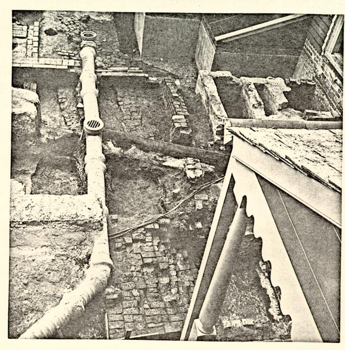 Plate I
Elevated view of various features unearthed immediately north of the restored main Geddy structure. The remains of a bulkhead are seen at bottom center, the northerly lean-to's northeast corner is in the center; beyond it lies the foundation for a porch and to the left of that the remains of brickpaving. The brassfounding shop's South wall and brick working plinth is at top left, and the west wall of a nineteenth century addition cuts through it. Photo from the west. 68-DB-2927
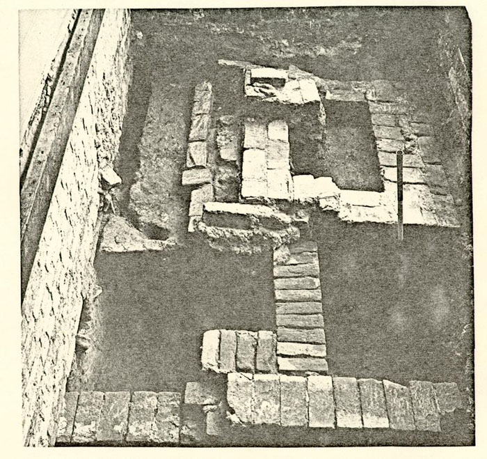 Plate II
The surviving foundations for the north extension (A2) of the earliest main structure (A1) encountered on Lot 161. The building's north wall (foreground) was abutted by the southeast corner of its northerly addition (rowlock construction). The extension's eastern wall had been cut through by a forge-like foundation (background). Perched on the forge are the remains of the footing for a lean-to (B2) associated with the extant Geddy house. The latter's north wing is visible at left. Photo from the south. 68-DB-2928
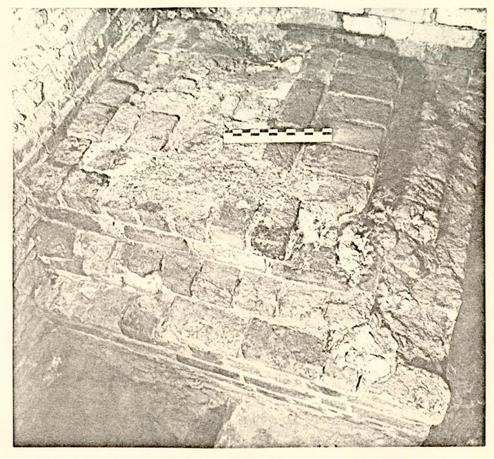 Plate III
The remains of the early main building's (A1) front porch as revealed beneath the stoop for the extant Geddy House. Photo from the southwest. 68-DB-2929
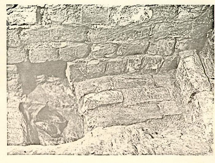 Plate IV
Early foundation (associated with the first building) protruding from beneath the existing main (B1) structure' west room chimney footing. The circa 1730 wine bottle at left had James Geddy's initials engraved on its side. Photo from the north. 68-DB-2930
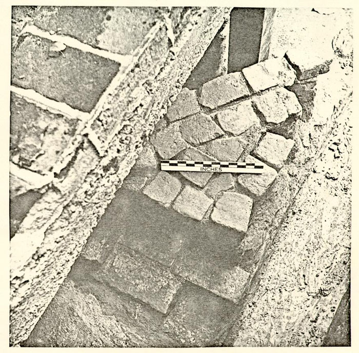 Plate V
Elevated view of the early main building's partially robbed north wall and the remains of a curving brick path associated with it. Photo from the S.S.E. 68-DB-2931
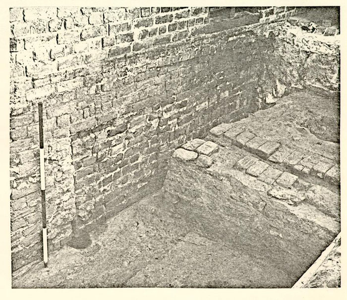 Plate VI
Underpinning for the c.1750 dwelling's south wall beneath the room adjoining the "east tenement". The drain at right belonged to the earlier main structure (A1). Photo from the southwest. 68-DB-2934
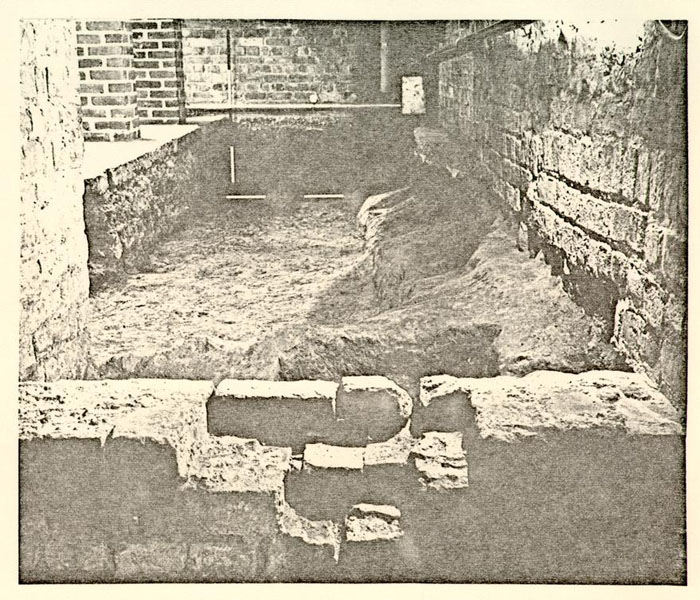 Plate VII
Crudely constructed cellar beneath the c.1750 main building's north wing. The lower two-brick courses at right were inserted while the basement was in use. The east/west wall in the foreground was originally the north wall of an earlier cellar. Photo from the south. 68-DB-2935
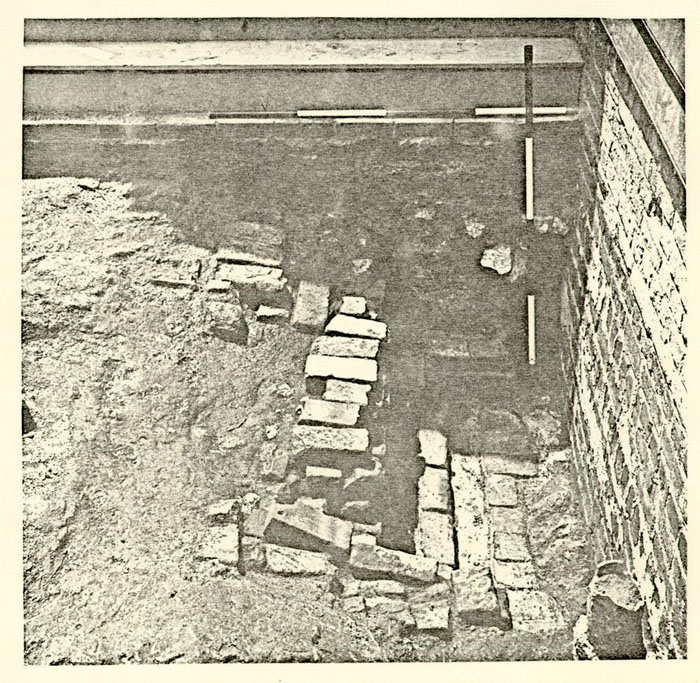 Plate VIII
The remains of the bulkhead entrance to the cellar beneath the extant James Geddy House's north wing. Photo from the north. 68-DB-2990
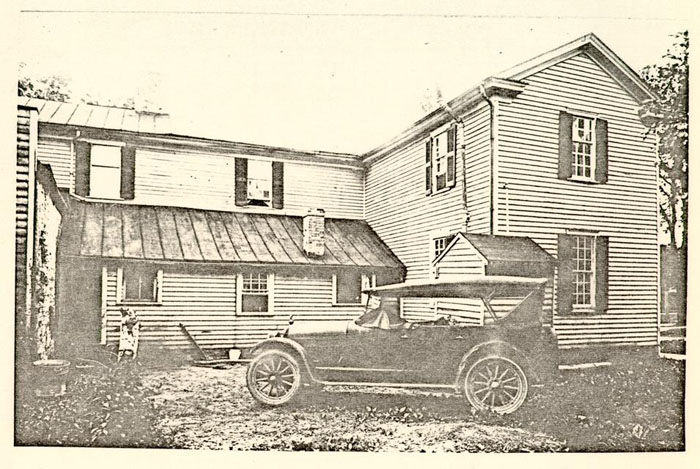 Plate IX
View of the north side of the Geddy House with its lean-to before restoration work in 1930. Photo from the N.N.E. S-1199
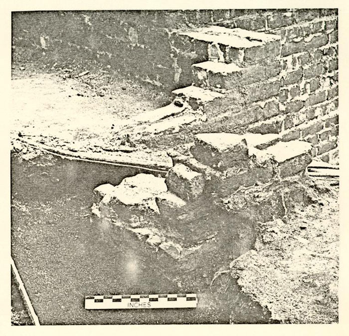 Plate X
Original northeast corner of the c.1750 dwelling's northerly lean-to (B2). Notice the notching on its eastern end (left) which enabled a later easterly addition to bond to the original brickwork. The overlapping upper courses were part of a 19th century repair to the lean-to foundation. Photo from the northeast. 68-DB-2932
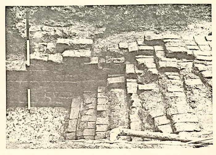 Plate XI
Bulkhead steps constructed when the northerly lean-to was added to the c.1750 dwelling. The west wall of the passageway which passed beneath the extension can be seen at left center. Photo from the east. 68-DB-2933
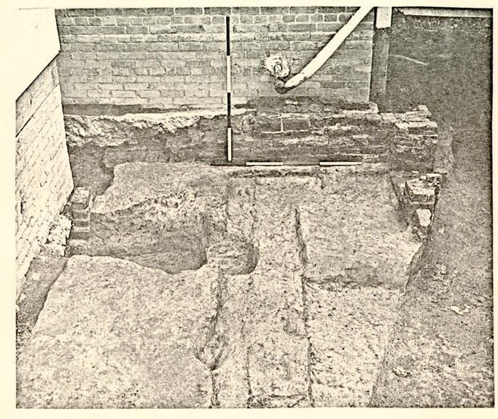 Plate XII
Surviving brickwork from brass-foundry's (D1) central H-shaped chimney. Modern sewer line at right cut through a portion of the fireplace's south edge. Photo from the west. 68-DB-2936
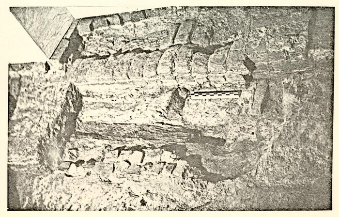 Plate XIII
Elevated view of features unearthed in the brass-working structure's (D1) east room. The foundation in the right background was the northern cheek of a chimney that was subsequently converted into a forge, the foundation of which is to be seen to the left of it. The forge was later removed and the footing converted into an open hearth. The wooden beam (center) presumably was to keep the first hearth bricks in place. The bricks in the foreground could have-been part of an earlier floor. Photo from the east. 68-DB-2937
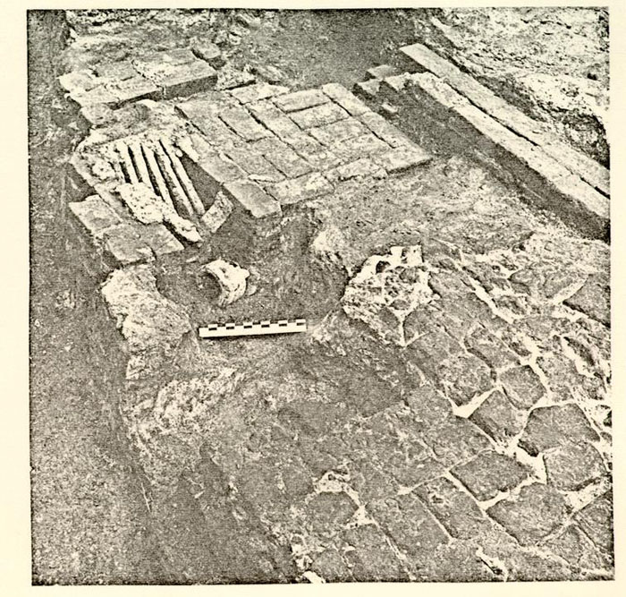 Plate XIV
Forge and working plinth foundation with grating bars still in situ within the brass-foundry's western addition (D3). Note wine bottle of about 1730 lying in the ash pit entrance. The brick paving in the foreground was laid after the forge was dismantled and has been partially removed to expose the foundations sealed beneath it. Photo from the west. 68-DB-2938
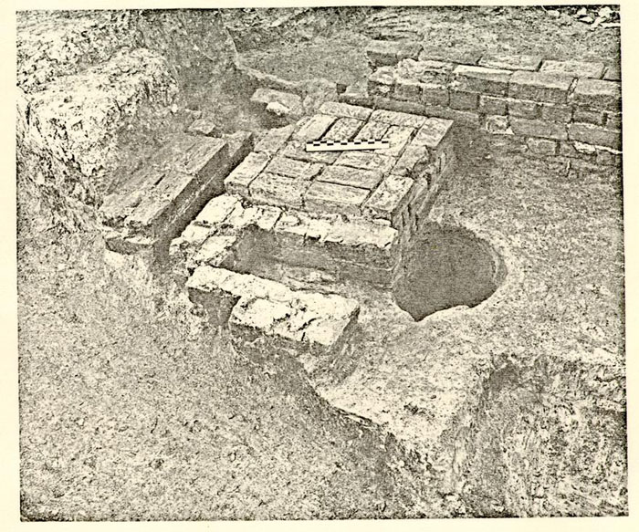 Plate XV
View of the brassfounding shop's (D3) forge and working plinth (following partial dismantling of the ash pit), along with portions of the addition's east and south walls. Photo from the northwest. 68-DB-2940
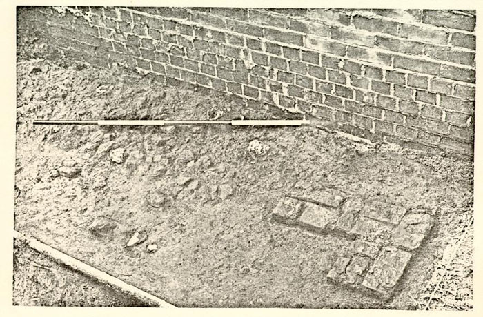 Plate XVI
View of the pier-supported structure's (G) southwest corner with the building's brick rubble path beyond it. The reconstructed kitchen (F) is in the background. Photo from the northwest. 68-DB-2939
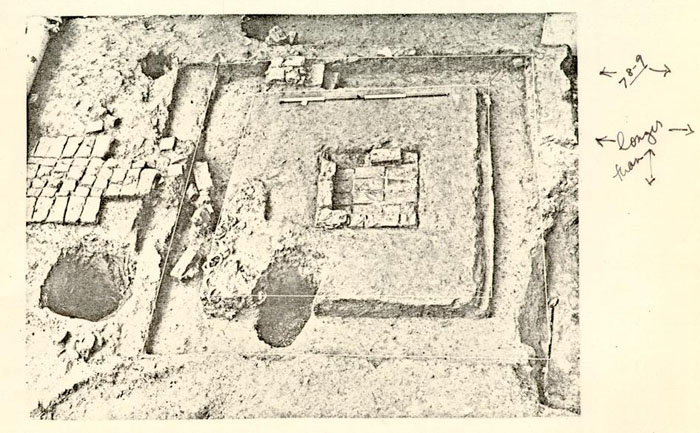 Plate XVII
Elevated view of the smokehouse (H) remains uncovered west of the reconstructed kitchen (F). Path at left indicated the location of the building's entrance. Photo from the east. 68-DB-2941
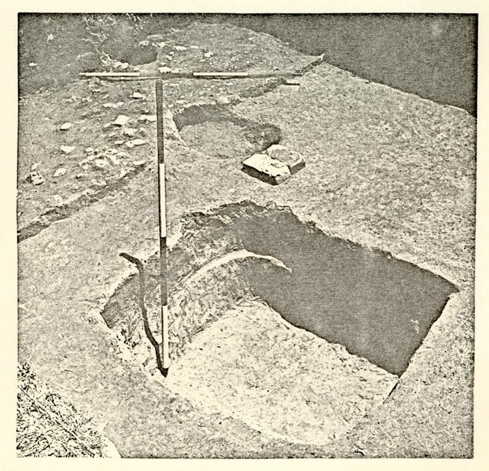 Plate XVIII
View of excavated privy pit with the structure's probable southeast pier in center background. The building's access path is to be seen at top left. Photo from the northwest. 68-DB-2942
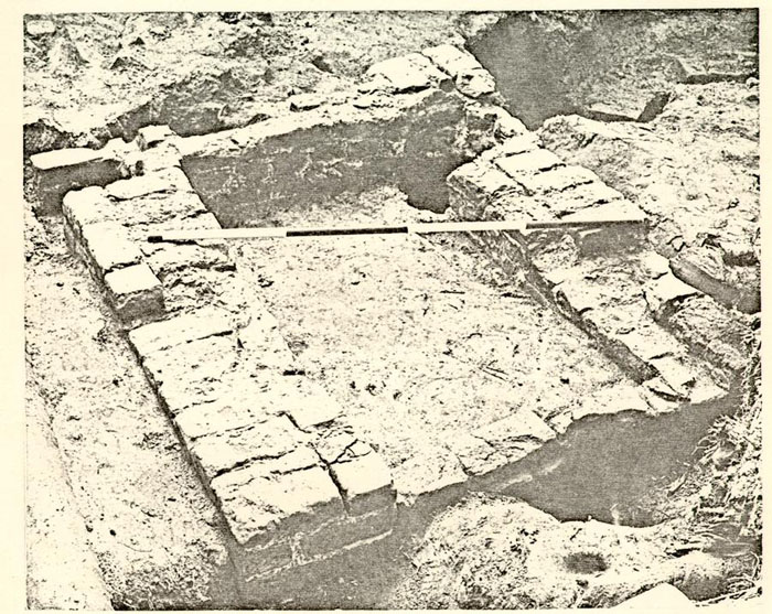 Plate XIX
View of the outdoor forge foundations discovered near the reconstructed kitchen's (F) southeast corner. Photo from the northwest. 68-DB-3143
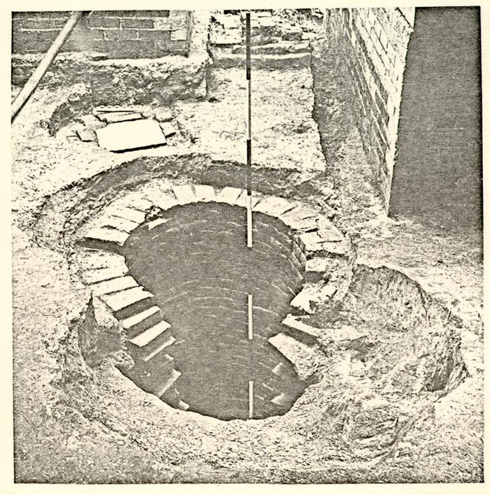 Plate XX
Well B as first uncovered showing the hole in the lining which apparently caused its abandonment. The supposed barrel stand is seen in the background. Photo from the north. 68-DB-2944
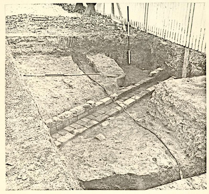 Plate XXI
View of the brick drain discovered outside the Geddy property's existing western fenceline. Photo from the S.S.W. 68-DB-2945
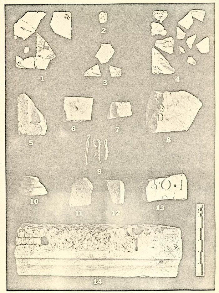 Plate XXII
Architectural fragments. (69-PH-829)