The Printing Office and Post Office (LL) Archaeological Report, Block 18-2 Building 12B Lot 48Originally entitled: "General Report on the Excavated Foundations of the Virginia Gazette Building
Colonial Lot #48, Block 18"
Colonial Williamsburg Foundation Library Research Report Series - 1431
Colonial Williamsburg Foundation Library
Williamsburg, Virginia
1990
GENERAL REPORT ON THE EXCAVATED FOUNDATIONS OF THE VIRGINIA GAZETTE BUILDING
COLONIAL LOT #48, BLOCK 18
See Report by the Department of Research and Record entitled, "Virginia Gazette Printing Office Site."
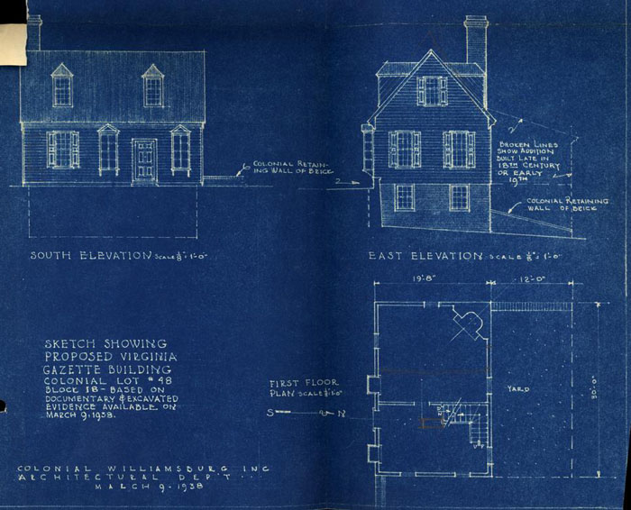
See accompanying sketch showing the design of the proposed Gazette Building at the scale of 1/8" = 1'0".
See also measured drawings of the foundations.
The excavations at the site of the Virginia Gazette began February 16, 1938. The site was badly cluttered with trash and debris dumped there after the fire which destroyed the Braithwaite Store. The store was built on the ruins of the earlier Gazette building which in turn burned in 1896. Much work had been done by the City after the Braithwaite Store fire to fence off the deep cellar from the sidewalk and to build retaining walls to prevent the sidewalk and adjacent property from falling into the cellar. In so doing, much original colonial brick work was replaced or repaired while considerable new brickwork was built.
The site was further cluttered with numbers of trees and bushes, whose roots had penetrated the old and new brick walls in many places. The trees had to be removed, therefore, with care so as not to disturb the wells and paving. Wood bracing had also to be built to prevent caving in of the sidewalk and adjacent higher ground as the excavation lowered into the old cellar. These features complicated and made difficult the excavation work.
The cellar, old walls, and paving, etc. were finally cleared, exposing the original building foundations. Here and there walls and piers of the Braithwaite store intruded. These, after examination and recording, were removed to make the original work more accessible.
The original structure was 30 feet long by 19 feet 8 inches wide, approximately. It exhibited two general building periods, one early and the other late in the 18th century.
The first period was identified by a study of the brickwork along the south wall particularly. Here it was noted that the first wall had fallen into the cellar, the debris lying on the brick paved floor. This debris seemed to have been spread to an even thickness 2 over all the basement floor on which another floor of brick paving was laid. In rebuilding the south wall several buttresses were added for extra strength. These rested on the upper or second paving which thus identifies them. In the collapse of the wall, only the portion of the south wall between its two corners was affected. All the corners, the east and west walls, and small portions of the northern, were found to be of the first or original period. Investigation of the chimney foundation identified it with the first period since the first paving continued into the fireplace as its underfire. To a similar manner the second paving likewise was treated.
By saving carefully all fragments found between the first and second paving, it was possible to establish an approximate dating for the second paving since it could be no earlier than such fragments. The fragments of china were of types common only at the end of the l8th and in the early 19th centuries. A brass drawer escutcheon of the same period is consideredcorroborative evidence.
North of the original cellar walls was found a continuation of the west wall. Although colonial, this wall appeared as later, partly due to a difference in brick size and partly due to the fact that it was not bonded to the original building. It was laid in the typical English bond and its jointing was pointed and lined — a treatment only found at this period on outer faces of exterior walls. Thus its use was readily established as a retaining wall to hold back the higher ground along the lot line. Going eastward from the northern termination of the retaining wall was found a series of brick piers terminating at the east in a corner, which once was connected to the original house by a continuous wall running south — evidences of which were found only in the form of its traces in the soil filled with rubble. This wall and piers were the supporting elements for a leanto or shed addition to the original structure which thus employed the northwest retaining wall as one side. The Frenchman's Map indicates a building whose dimensions would include such an addition. The brickwork comprising the northeast wall and north piers is later than that of the original building. One assumption, then, is that the leanto was constructed just before the Frenchman's Map was drawn and dated (1781). Although much care was expended, no evidences of earlier piers or walls could be found. Thus they and the retaining wall may be assumed to be the proper design controls for the leanto or shed, were it decided to incorporate this feature (shown on the accompanying sketch by broken lines).
3Our recommendation on the basis of all available evidence is that the building should be restored to the original period without the leanto. Since the piers and east wall of the leanto portion are much later than the original building, the period of the leanto is problematical. after 1846Considering all the evidence, our opinion leans toward dating the leanto at 1840, plus or minus.1833 possibly 1846 If it is necessary to have added space in the building for tenants' convenience, the evidence is not strong enough to preclude the leanto being constructed and the assumption of its original date as just previous to 1781.
Running east from the southeast corner, and overlapping it but not bonding with it, was found a heavy brick retaining wall. This may well be a part of the work done by the colony in 1720 to level the Duke of Gloucester Street, previous to that time much cut up by ravines such as that east of the Gazette building. Mr. Charles, in his "Recollections", mentions this wall as having extended above the sidewalk in such a way as to provide a sitting place for those who loafed about the dram shop in the Gazette Building at the time of the Civil War and shortly thereafter. This should prove to be, if properly designed and rebuilt, an attractive feature running eastwards from the Gazette to the site of the next colonial structure.
All excavated earth and debris antedating the fire of 1896 was carefully sifted. Several interesting fragments and relics were found of the colonial period. Some lead type were found which may prove to be of interest. A number of fragments of diamond-shaped leaded glass were found and at one point a number of the small panes without their attendant lead cames or divisions. Since this type of glazing was common to the 17th century casement sash and since no building was on this site prior to 1719, it is safe to assume the fragments represent the fact that the printer collected such sash to obtain lead for type molding. The further fact that several of the panes were found without the lead divisions would lend weight to this theory because such thin glass panes found in debris unbroken would certainly retain their cames. In other words, any disturbance sufficient to tear away the cames would be sufficient to fracture the glass.
4At the western end of the south wall and outside it toward the sidewalk was found a small enclosure of shallow brick walls, not bonded to the main foundation walls. They may have been the support for some sort of steps, but the mortar has no definite traces of oyster shell lime, indicating their period as later than period two. This is further borne out by the fact that they do not bond with the main wall, which at this point is period two.
The evidence in Mr. Charles' "Recollections" of the foundations themselves and particularly of the two photographic views of the Gazette in the Coleman collection taken before the 1896 fire afford sufficient data to restore this structure very closely to its original appearance. The accompanying sketch shows a window in place of a door and corner window at the west. Close inspection of the views under the glass shows weatherboards at the door jamb where the trim would occur in the colonial period. The position of this opening appears symmetrically arranged in the facade, however, and it is to be supposed that an original window and trim were removed and replaced with the crude opening of the view when the structure was made into two shops. The window at the west corner shown in the two views is eliminated in the accompanying drawing not only because its position and shape is not in accordance with known colonial precedent, but also because the division of the structure into two shops would necessitate another window at this point.
The two small windows shown in the photographic views are included in the accompanying sketch. They are similar to two known colonial examples. The sketch does not show shutters for them which eventually should be included in the design of the building. The shutters would be in pairs for each window, each half pair consisting of two hinged valves so that when closed the whole window could be covered and when open, each half pair would fold back flat against the weatherboards at the sides of the windows. The dormer windows are shown on the sketch as they appear on the photographic views. Mr. Charles' "Recollections" states that there were two.
March 10, 1939
Concurred:
A. E. Kendrew
(Final Sheet with Confidential figures filed "Personal & Confidential")
Architectural Dept.
Written by
S. P. Moorehead
For purposes of comparison and study, the cubic content of the building as shown on the sketch is stated, approximately, below. An approximation of the cost of constructing the building, based on the cubic content, is also shown.
| Total cubic feet, original building | 18,442 |
| Total cubic feet, leanto | 7,336 |
| Total cubic feet, including both | 25,778 |
Probable cost per cubic foot — 70¢ — by E. R. Holland
| Cost of original building | $12,909 |
| Cost of original building with leanto | 18,044 |
March 10, 1938
Concurred:
A. E. Kendrew
Architectural Department
Written by:
S. P. Moorehead
March 10, 1938
To: Memorandum to the FilesFrom: Mr. Moorehead
Miss Parlow's remarks on the Virginia Gazette Office before the Fire of 1896
Miss Barlow recognized the building from a photographic view of the Coleman Collection, showing the south elevation. She remembered the two dormers and all the openings on the first floor — from west to east: corner window, door, window, door, window. She recalled two rooms on the first floor and that there was a stair there but could not remember its position in plan. She remarked that the projecting windows shown on the photograph had been removed and replaced with windows flush with the wall of the house. She said further that the shop windows in the old store on the corner of her property were similar.
S. P. M.