Printing Office and Post Office (LL) Archaeological Report, Block 18-2 Building 12B Lot 48Originally entitled: "The Virginia Gazette Site Archaeological Volume II Excavations of 1951-1952 Colonial Lot 48 Block 18 Archaeological Area H"
Colonial Williamsburg Foundation Library Research Report Series - 1417
Colonial Williamsburg Foundation Library
Williamsburg, Virginia
1990
To: Mr. Campioli
From: A. E. Kendrew
Re: Virginia Gazette Site
Under date of October 29, 1954, you transmitted to Mr. Cocke two copies each of the three volumes of the Archaeological Report on the Virginia Gazette Site.
As a result of our recent agreement with Mrs. Haughwout whereby she is contributing all of the artifacts uncovered from the site to Colonial Williamsburg, Mr. Cocke thought it was not necessary for us to give Mrs. Haughwout the two copies of the report and therefore he returned them to me.
I am debating whether it would be a gesture of good will to offer at least one copy of this report to Mrs. Haughwout, and therefore I am retaining one set in my office. The other set is being returned to you herewith.
AEK
A.E.K.
Attachment
THE VIRGINIA GAZETTE SITE
Colonial Lot 48
Block 18 Archaeological Area HARCHAEOLOGICAL RECORD
Volume II
Excavations of 1951-1952
Volume I - Excavations of 1938
Volume III - Archaeological Laboratory Report
The material in this report was compiled and edited by Orin M. Bullock from the material found in the files and in consultation with S. P. Moorehead, Paul Buchanan, and James Knight.
October 15, 1954
VOLUME II
Archaeological Report
VIRGINIA GAZETTE SITE
Contents
- Preface to Volume II.
- List of Photographs.
- Archaeological Report of Excavations of 1952.
- Archaeological Survey of Foundations, dated Aug. 15, 1952, Sheet 1.
- Archaeological Survey of Foundations, Southern half, dated Aug. 15, 1952, Sheet 3.
- Archaeological Survey of Foundations, Northern half, dated Aug. 15, 1952, Sheet 4.
- Existing and Substrata Topography, May 1952.
- Sizes of Colonial Lots, dated April 12, 1938.
- Preliminary Research Report on Site.
PREFACE TO VOLUME II
This report describes the findings revealed by the archaeological excavations of Colonial Lot 48 in Block 18, known as Archaeological Area H, which were made in the winter of 1951-1952 by J. M. Knight of Colonial Williamsburg.
The lot was excavated in 1938 (see Vol. I) but the work at that time was confined to the immediate site of the Virginia Gazette building shown as building "A" on the following drawing. Refer to Volume I for a report on this excavation.
The 1951-52 "dig" followed the cross-trench method and covered the entire property. This method of excavation is somewhat less thorough than the "layered excavation" method, but it probably revealed all important foundations within the area which were then carefully uncovered and traced out.
Relatively few artifacts were recovered from the 1951-52 excavation. The agreement with Mrs. Haughwout permitting this excavation of her property is silent on the ownership of artifacts recovered. Those which were recovered are not identified as such and are all stored with those, identically marked, from the 1938 dig.
The foundations exposed by the excavation were left exposed, protected by barricade fences. The test trenches were back filled. Large trees were left standing and excavations avoided their roots.
ILLUSTRATIONS
(See plan page 4 for locations)
| 53-953 | Virginia Gazette Site from the East, c. 1885 | 6 |
| N-4427 | Virginia Gazette Site from the East, 1933 | 7 |
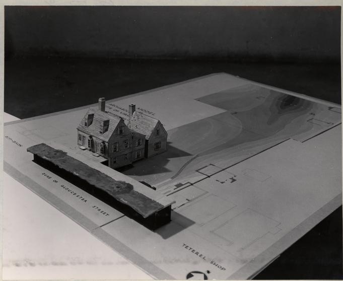
| 53-DD-4892 | Model of Lot 48 showing topography | 8 |
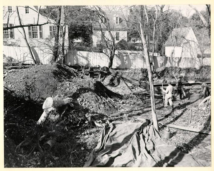
| 51-W-2005 | Lot 48 looking South from Lot 49, December 1951 | 10 |
| 52-T-144 | Building B, January 1952 | 12 |
| 52-T-145 | Building B, January 1952 | 13 |
| 52-T-557 | Building B, April 1952 | 14 |
| 52-T-558 | Building B, April 1952 | 15 |
| 52-T-723 | Building B,May 1952 | 16 |
| 52-T-757 | Building B, May 1952 | 17 |
| 51-W-2007 | Building B, December 1951 | 18 |
| 52-T-756 | Building C, May 1952 | 20 |
| 52-T-755 | Building C, May 1952 | 21 |
| 51-T-2139 | Building C, Fall 1951 | 23 |
| 51-T-2142 | Building C, Fall 1951 | 24 |
| 52-T-724 | Building D, May 1952 | 26 |
| 52-T-727 | Building D, May 1952 | 27 |
| 52-T-728 | Building D, May 1952 | 28 |
| 52-T-562 | Building E, April 1952 | 30 |
| 52-T-560 | Building F, April 1952 | 32 |
| 52-T-559 | Building G, April 1952 | 34 |
| 52-T-561 | Building G, April 1952 | 35 |
| N-3625 | Building H, January 1933 | 37 |
| 52-T-649 | Building H, April 1952 | 39 |
| 52-T-648 | Building H, April 1952 | 40 |
| 51-W-2004 | Building H, December 1951 | 41 |
| 51-W-2006 | Building H, December 1951 | 42 |
| 51-W-2008 | Building H, December 1951 | 43 |
| 51-W-2010 | Building H, December 1951 | 44 |
| 51-W-2011 | Building H, December 1951 | 45 |
| 52-T-647 | Building H, April 1952 | 46 |
| 52-T-556 | Building J, April 1952 | 48 |
| 52-T-726 | Building K, May 1952 | 49 |
| 52-T-725 | Building K, May 1952 | 51 |
| 53-DD-4889 | Model of Virginia Gazette Buildings | 55 |
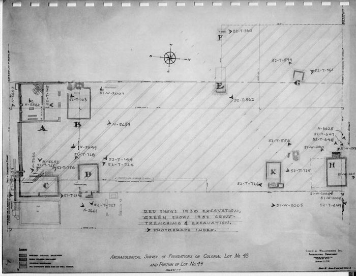 ARCHAEOLOGICAL SURVEY OF FOUNDATIONS ON COLONIAL LOT NO 48 AND PORTION OF LOT NO 49
ARCHAEOLOGICAL REPORT
OF
EXCAVATIONS OF 1952
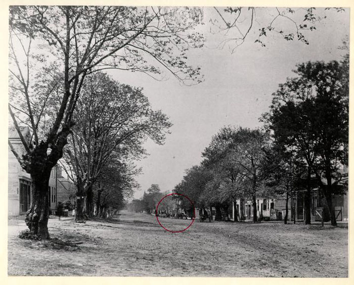 VIRGINIA GAZETTE SITE ABOUT 1885.
 VIRGINIA GAZETTE SITE FROM EAST, 1933, N 4427
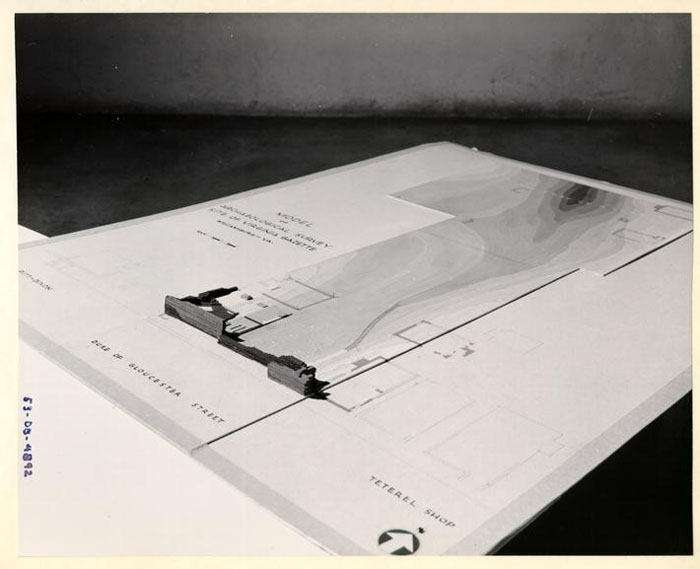 MODEL OF LOT 48 SHOWING TOPOGRAPHY AND FOUNDATIONS.
SECTION III
Excavation of 1952-53
(area cross hatched in green on illustration page 4)
Nature of the Site
The site was heavily covered with scrub growth and occupied by several shack dwellings of a very temporary character.
The elevations and topography of the area continued the downward slope established along the south end of the lot. (See photograph of model #53-DB-4892 opposite.)
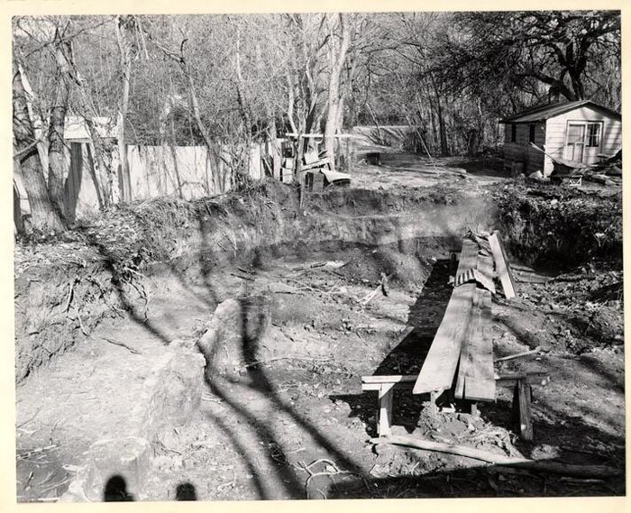
Excavation
The area was completely cross-trenched at approximately seven foot intervals, avoiding only the larger trees. Trenches were carried down to undisturbed soil. All remains of 18th century masonry were then carefully uncovered.
Work was hampered by wet weather, trees, and shrubs, and the great depth of the fill encountered.
The remains located and uncovered are labeled B, D, E, F, G, H, J, K, and the north portion of C which was partially excavated in 1938.
Detailed Descriptions
Building "B"
See photos 52-T-557, 52-T-558, 52-T-757, 52-T-723, 52-T-144 and 52-T-145.
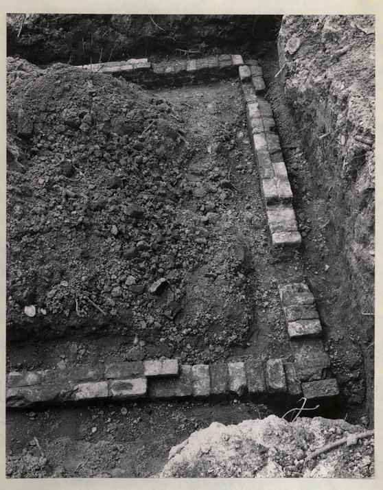
General
The remains of a brick foundation for a building approximately 18' x 24' with evidence of a chimney at the west end were uncovered approximately 11 feet below the existing sidewalk elevation on Duke of Gloucester Street.
10
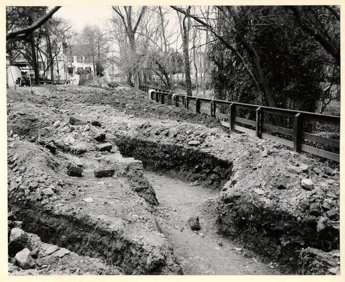 LOTS 48 & 49, DEC. 1951, PHOTO. 51-W-2005
11
The walls were one brick thick (9") and varied from 4 to 6 courses high. They were found about 4 feet below the surface of the ground. The 18th century grade was about five feet below the surface.
LOTS 48 & 49, DEC. 1951, PHOTO. 51-W-2005
11
The walls were one brick thick (9") and varied from 4 to 6 courses high. They were found about 4 feet below the surface of the ground. The 18th century grade was about five feet below the surface.
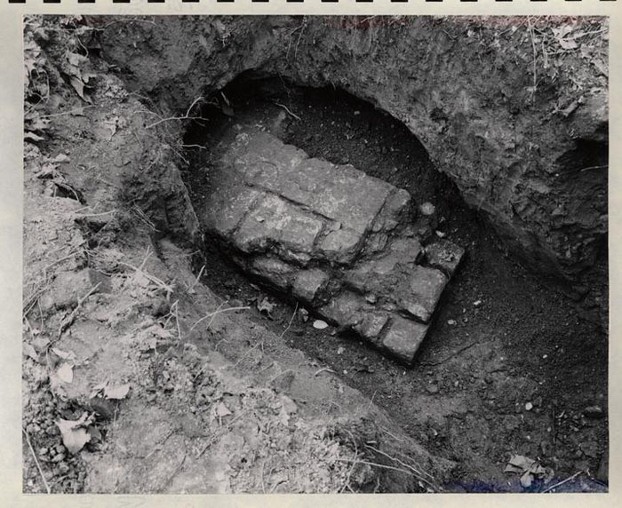
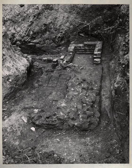
Floor
A small area of brick paving, a portion of the fireplace hearth and underfire, laid on a mortar bed was uncovered about two feet above the bottom of the walls. No other evidence of former floor elevation could be found.
Brick
9 1/8 X 4 3/8 X 2¾ - Buff and light red.
Mortar
Shell.
Bond
English
Age and Condition
As early as any brick work found on lot 48. Too badly deteriorated to use for building construction.
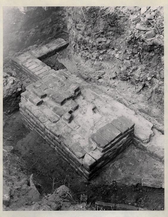
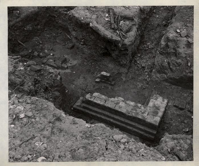
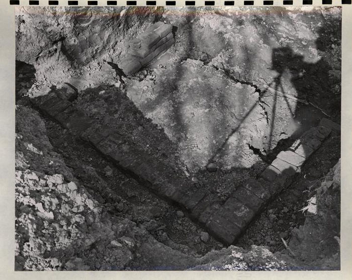
Chimney
See next photo 52-T-723
The chimney and the west wall of the building could only be established by careful excavation which revealed the marks of former occupancy in the soil, which showed a clearly defined fill of brick bats and shell mortar. The nature of the soil was such that no evidence was revealed at the southwest corner nor could the extent of the retaining wall running north from Building A be established.
12
 BUILDING B. JAN. 1952. PHOTO. 52-T-144
 BUILDING B. JAN. 1952. PHOTO. 52-T-145
 BUILDING B, APRIL 1952, PHOTO. 52-T-557
 BUILDING B, APRIL 1952, PHOTO. 52-T-558
 BUILDING B. MAY 1952, PHOTO. 52-T-723
 BUILDING B, MAY 1952, PHOTO. 52-T-757
 BUILDING A, DEC. 1951, PHOTO. 51-W-2007
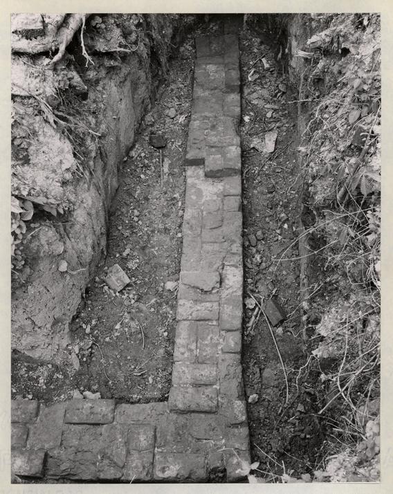
Miscellaneous
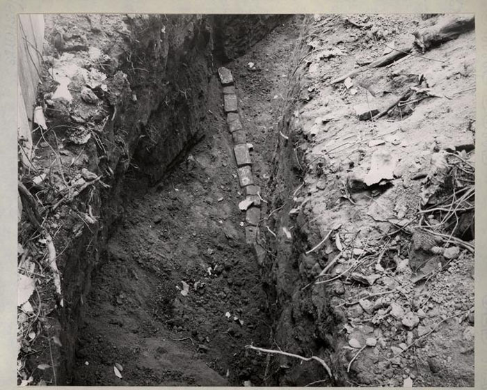
Running north and south, in line with the west wall and about 11 feet north, a 9 foot length of a single course of brick was uncovered.
The brick was of two sizes, 8 ¼ x 3¾ x 2¾ and 8 ½ x 4 1/8 x 3 and was not laid in mortar.
The work could not have been a building foundation, it might have been a walk edging.
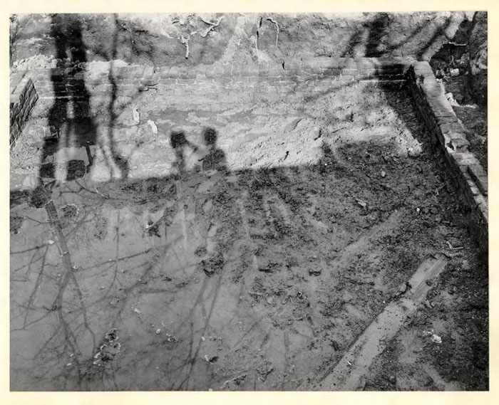
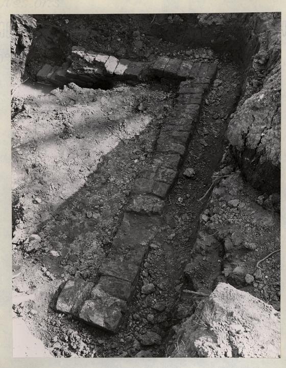
Building "C"
See photos - N-5666,51-T-2139, 51-T-2142, 52-T-755, 52-T-756 51-T-2139, 51-T-2141
General
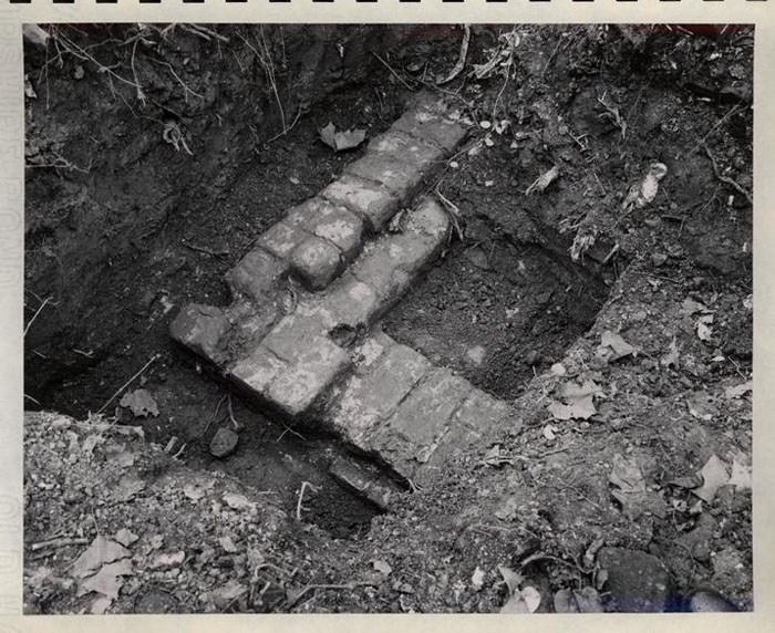
A portion of this foundation was at the southwest corner uncovered in the 1938 dig and the entire complex was excavated during the 1952-53 dig.
The remains reveal a building approximately 16' x 32' with a chimney on the west wall about 5 feet from the northwest corner. The foundation seems to have been laid in two periods, a portion to the south about 16' x 16' being the earlier.THE FRONT PORTION WAS BUILT BEFORE THE RETAINING WALL 1-30-5 PB
The building was of wood as indicated by an insurance policy covering the property to the east which reads in part "distanced 3 feet from one wooden house." (research report p. 55)
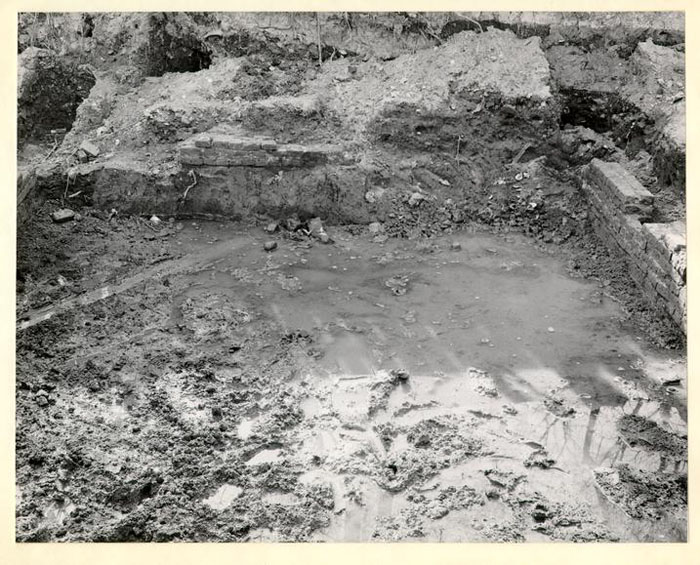
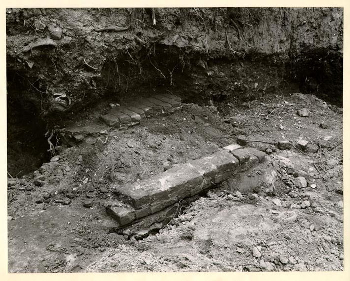
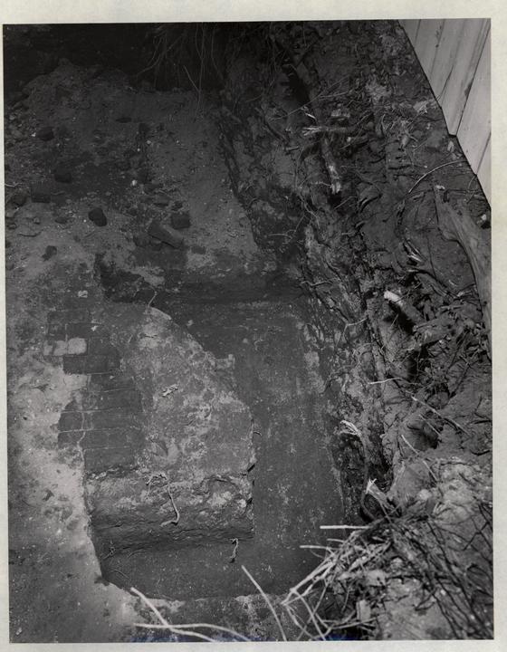
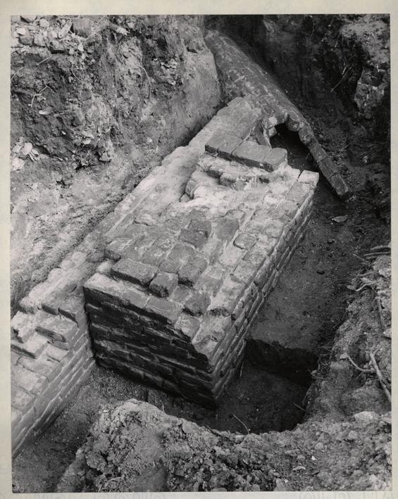
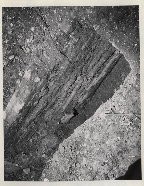
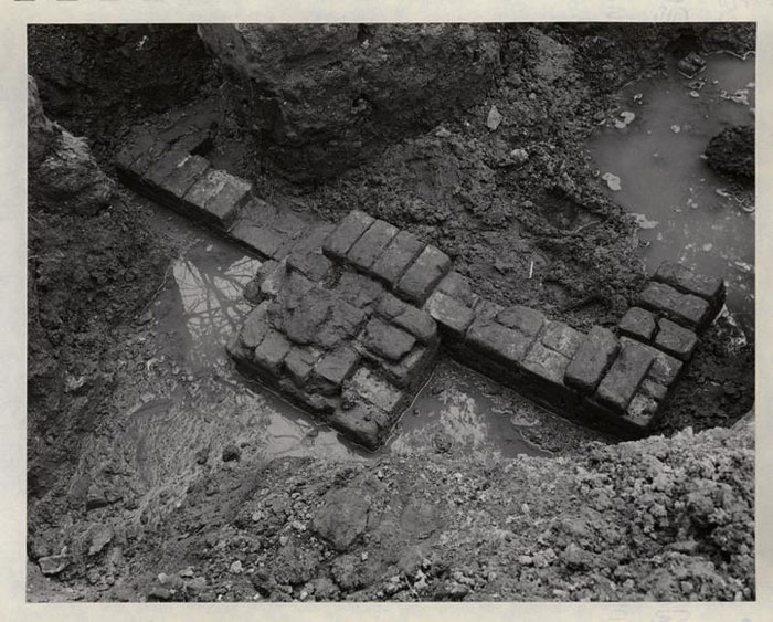
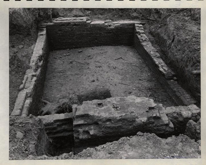
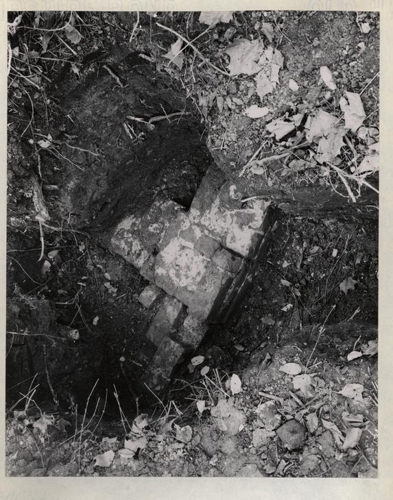
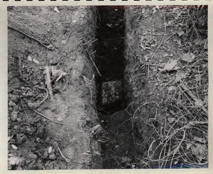
A still earlier brick drain was found under the west wall which was not completely excavated. (see photo 52-T-756) It was apparently no longer in service when the house was built since the house foundations break through the drain. The heavy brick retaining wall along Duke of Gloucester Street also pre-dates this building foundation. The relieving wall and bulk head steps found just west of the building are probably somewhat later. (see photo N-5666)
20
 BUILDING C, MAY 1952, PHOTO. 52-T-756
 BUILDING C, MAY 1952, PHOTO. 52-T-755
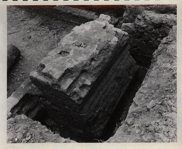
The south wall is one brick thick and the northwest wall is one and one half brick thick; about 8 courses remain in place. The south wall was found about 4 feet below the elevation of the sidewalk along Duke of Gloucester Street, and the northwest section was about 8 feet below the sidewalk. The bottom of the wall varied in elevation, doubtless following the original grade.
Floor
No positive evidence establishing the original floor elevation was uncovered, but excavated material and depth of the foundation footings indicate that there was a full basement under the entire building.
Brick
7½ x 3¾ x 2½ (south portion) 8¾ x 4¼ x 2½ red and buff (north portion)
Bond
English
Mortar
Shell
Age and Condition
The brick and mortar are like similar material known to date from late 18th century.
The Frenchman's map of 1782 indicates a square building on the site which is somewhat shorter than the adjacent building to the east. (The map shows the three buildings in this group as one, doubtless because they are so close together.) This agrees with the archaeological evidence which reveals two periods of construction, a 16' x 16' building at the street with a 16' x 16' addition to the north. The south portion was no doubt erected prior to 1782, and
23
 BUILDING C. FALL 1951, PHOTO. 51-T-2139
 BUILDING C, FALL 1951, PHOTO. 51-T-2142
25
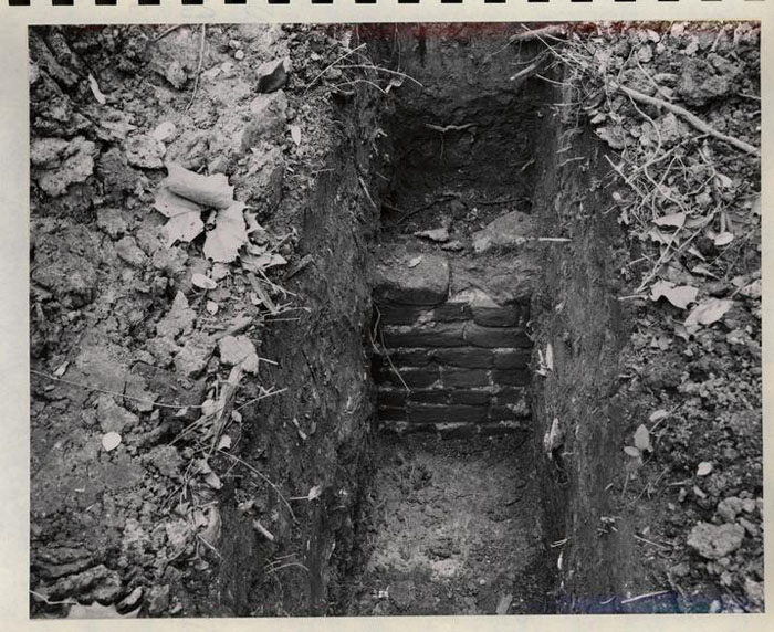
in 1772, William Hunter was charged for a "drain to his Printing Office Lot" (see ft. note p. 56 research report) which would indicate that the building construction was later than that date since the foundation was built over the drain. The north was later, but probably still within the 18th century. The chimney foundation is not bonded to the building wall and was no doubt laid after the wall. no PB
BUILDING C, FALL 1951, PHOTO. 51-T-2142
25
in 1772, William Hunter was charged for a "drain to his Printing Office Lot" (see ft. note p. 56 research report) which would indicate that the building construction was later than that date since the foundation was built over the drain. The north was later, but probably still within the 18th century. The chimney foundation is not bonded to the building wall and was no doubt laid after the wall. no PB
The brick and mortar has deteriorated to such an extent that the foundations cannot be used for building construction.
Building "D"
See photos 52-T-724, 52-T-727, 52-T-728
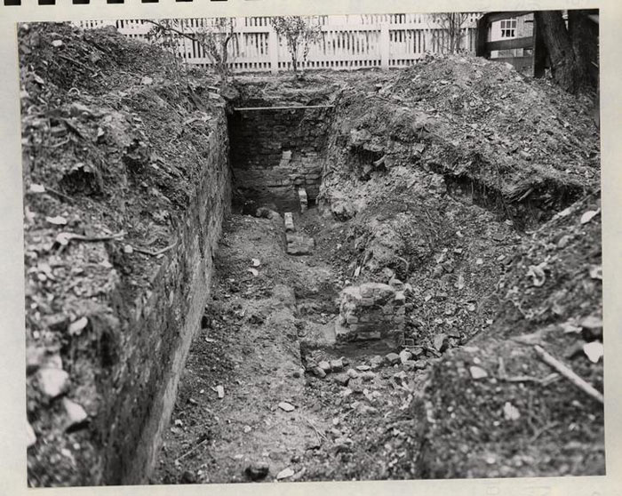
General
These remains of a brick foundation, 1½ brick thick, for a building approximately 16' x 22" with a chimney at the east end were found just below the 18th century finished grade and about 3 feet below the present ground surface.
The building lapped over the colonial lot line, the chimney being almost entirely in lot 49.
The entire area within the foundation walls was not excavated because of the depth of the remains below the surface and the existence of fine trees on the site.
No specific literary reference to this structure has been found and it is not indicated on the Frenchman map. It may have been a dependency to building "C" which stood 16 feet south.
Floor
The excavation did not reveal either the type nor elevation of the floor. DEC 56
dug & found that the floors were wood
PB
 BUILDING D. MAY 1952. PHOTO. 52-T-724
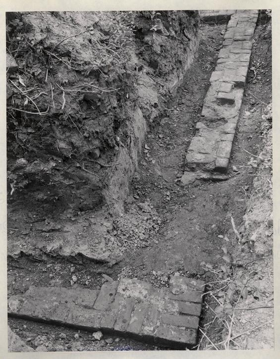
 BUILDING D. MAY 1952. PHOTO. 52-T-727
 BUILDING D, MAY 1952, PHOTO. 52-T-728
Brick
8¾ x 4 3/4 ? 4 3/8?x 2¾ Red and buff color
Bond
Flemish
Mortar
Shell
Age and Condition
The Frenchman's map (1782) does not show this building, and an insurance policy of 1806 (see research report p. 55) neglects to mention a building in this location, but does mention the one 16 feet south (Building "C") and another to the east. The brick, mortar, and bond are similar to that of the second quarter of the 18th century. Building "D" may have stood in 1750 and have been removed before 1782.
Only 2 or 3 courses of brick work remain and while their condition is relatively good, the work is not suitable for re-use as a building foundation.
Building "E"
photo 52-T-562
General
These remains, of one end (east) of a brick foundation for a building approximately 8' wide with a minimum size (outside) chimney or step foundation, were found about 3' below the existing grade. The extent of fill and debris indicate that the building was approximately 18 feet long. (east and west)
If the signs of "site occupancy" actually define the building length, it straddled the colonial lot line. Through the years, lot 47 and 48 have been in one ownership occasionally which may provide acceptable evidence of the approximate date of the construction.
30
 BUILDING E. APRIL 1952. PHOTO. 52-T-562
It is safe to assume the building was one story wood since the wall is but one brick thick and the overall size of the building is small.
Floor
The excavations did not reveal either the type nor elevation of the floor.
Brick
8 3/8 x 4 x 2 5/8 dark and light red
Mortar
Shell
Bond
English
Age and Condition
Lots 47 and 48 were owned by John Dixon in 1774, (RR Lot 47, p. 5) and by William Hunter until 1800 (RR Lot 47, p. 9). The building may have existed during this period, but it does not show on the Frenchman's map. If standing was not shown on the insurance plot of lot 47 made in 1806, the character of the masonry remaining is not inconsistent with that of the third quarter of the 18th century.
The remaining brickwork is too badly deteriorated for use in reconstruction.
Building "F"
See photograph 52-T-560
General
Fragments of brickwork possibly forming the northeast corner of an outbuilding were located about 2½ feet below the existing grade. The wall was one brick thick and the brick were laid without mortar. Excavation
32
 BUILDING F. APRIL 1952. PHOTO. 52-T-560
33
failed to reveal evidence of the extent of the building or any information as to floor or superstructure.
BUILDING F. APRIL 1952. PHOTO. 52-T-560
33
failed to reveal evidence of the extent of the building or any information as to floor or superstructure.
The Frenchman's map indicates a small building in approximately this location, but somewhat to the south.
This site is entirely in colonial lot 47.
Building "G"
See photographs 52-T-559 and 52-T-561
General
These remains of the brick foundations of a building approximately 6' x 8', entirely on colonial lot 47 were located about 2 feet below the existing grade. The foundation walls are one brick thick and were open on the down hill (east side). The north and south walls stepped down following the original slope.
The building might have been a privy.
Floor
Excavation established no information.
Brick
8¾ x 4¾ x 2½ light red and buff.
Mortar
Shell
Bond
English
Age and Condition
No positive evidence has been formed which could establish the date of the work, it
34
 BUILDING G. APRIL 1952. PHOTO. 52-T-559
35
BUILDING G. APRIL 1952. PHOTO. 52-T-559
35
 BUILDING G. APRIL 1952. PHOTO. 52-T-561
36
is not inconsistent with small building foundations throughout the 18th century.
BUILDING G. APRIL 1952. PHOTO. 52-T-561
36
is not inconsistent with small building foundations throughout the 18th century.
The brickwork is in poor condition and cannot be used in reconstruction.
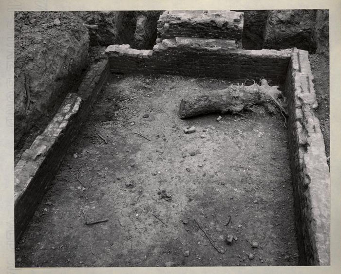
Building "H"
See photos N-3625, 51-W-2004, 51-W-2006 51-W-2008, 51-W-2010, 51-W-2011, 52-T-647, 53-T-649 52-T-648, 52-T-649
General
These remains of the brick foundations of a building approximately 16' x 22' with a chimney at the west end were found about 2 feet below the existing grade. All four walls were excavated as well as the entire site.
The bottom of the wall is about 6 feet below the existing grade and about 3 feet below the 18th century grade. A varying number of courses of the 1½ brick thick wall were found, averaging 5 courses high. The chimney was standing its full height (see photo N-3625) until 1940 when it fell. (The debris was heavily overgrown all over the building site and had to be removed before archaeological excavation could be made.) The wall at the west end is 2 brick thick, possible indicating a brick end.
An addition approximately 12' x 22' had been added to the south side in modern times. The one brick thick modern work, laid in yellow sand and lime mortar was not completely excavated. A large sycamore occupied the site and that in addition to the great depth of fill made excavation of modern work impractical.
No evidence of basement bulkhead was found, but at the southeast southwest corner (see photo 52-T-648) there is evidence of a doorsill about 15" above the probable elevation of the basement floor and at about natural 18th century grade on the exterior. (See 18th and modern topography, exhibit*——)
37
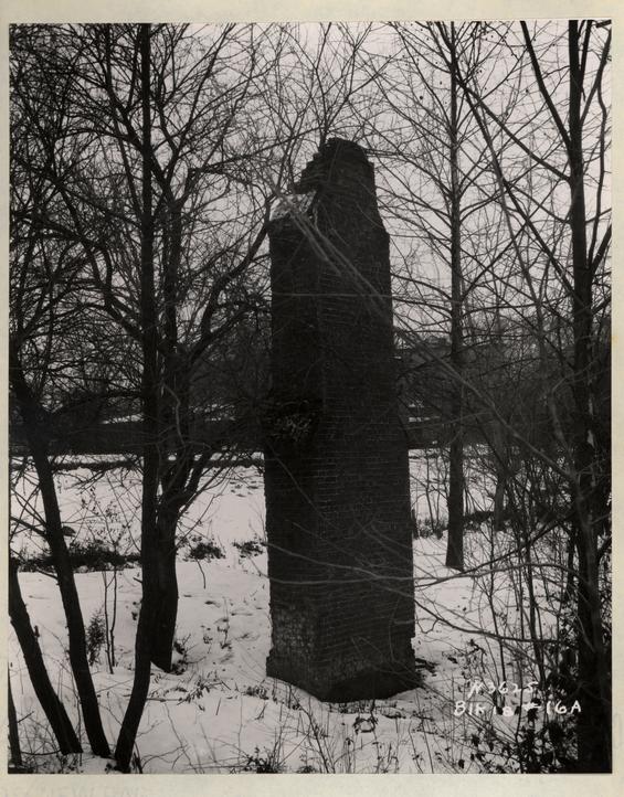 BUILDING H, JAN. 1933, PHOTO, N 3625
Historical research reveals that the house burned in the fire of 1896; it was erected by Humphrey Harwood to the account of William Hunter, Jr. in 1776-1777 and given under life tenure to his mother Elizabeth Reynolds. The kitchen with its oven was erected at the same time.
Floor
The original nature of the basement floor was not revealed by excavation; it might have been packed earth.
Brick
8¼" to8½" x 4 x 2 5/8 Light red and buff color.
Mortar
Shell
Bond
English
Age and Condition
Physical evidence confirms the documentary references referred to above that the walls were laid in the 4th quarter of the 18th century. The foundations were found to be in better than average condition.
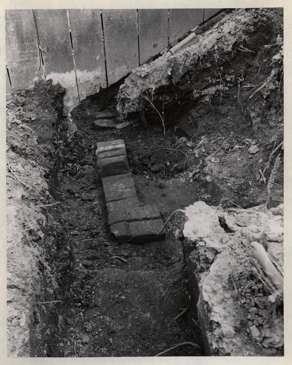
Building "J"
See photo 52-T-556
General
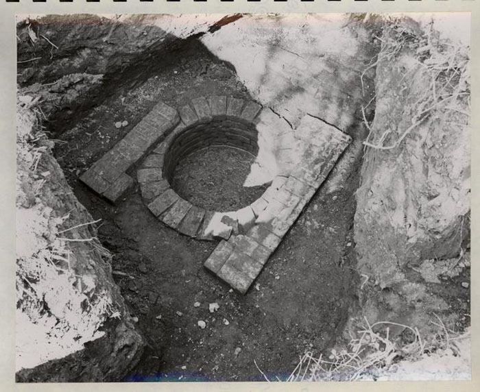
A 2' -8" diameter well and the foundations of a 4' -7" x 4' -7" well house were uncovered about 5 feet below existing grade which was the finished grade at this point in the 18th century as indicated by the brick paving found adjacent to the well.
39
 BUILDING H, APRIL 1952, PHOTO. 52-T-649
 BUILDING H. APRIL 1952. PHOTO. 52-T-648
 BUILDING H, DEC. 1951, PHOTO. 51-W-2004
 BUILDING H, DEC. 1951, PHOTO. 51-W-2006
 BUILDING H. DEC. 1951. PHOTO. 51-W-2008
 BUILDING H. DEC. 1951. PHOTO. 51-W-2010
 BUILDING H. DEC. 1951. PHOTO. 51-W-2010
 BUILDING H, APRIL 1952. PHOTO. 52-T-647
The well was not excavated nor was the full extent of the brick paving.
The well was doubtless part of the group comprising Elizabeth Reynold's property.
Floor
Natural grade paved in brick laid dry in running bond pattern.
Brick
8¼ x 4 1/8 x 2¾ dark and light buff.
Mortar
None
Bond
Laid as radial headers and stretchers with no regular bond.
Age and Condition
Last quarter 18th century. Exceptionally good.
Building "K"
See photos 52-T-725 and 52-T-726
General
The remains of the brick foundation of a building approximately 12' x 16' with a chimney and oven at the east end were found about 2 feet below the existing grade. All four walls were excavated.
The bottom of the wall is about 5 feet below the existing grade and about 2 feet below the 18th century grade. A varying number of courses of the one brick thick wall remain, averaging 4 courses high.
48
 BUILDING J. APRIL 1952. PHOTO. 52-T-556
 BUILDING K. MAY 1952, PHOTO. 52-T-726
The entire oven foundation was found, but only broken brick and shell mortar define the area of the chimney.
A portion of brick hearth and paving was uncovered, but the entire building area was not excavated.
Floor
Apparently may have been paved in brick, but the extent of the paving at the chimney is restricted to the underfire area.
Brick
8¼ x 3 7/8 to 4 x 2½ dark red and brown.
Mortar
Shell
Bond
English
Age and Condition
Last quarter of the 18th century, and too badly deteriorated for re-use as foundation.
The oven on the north side of the chimney is clearly defined (see photo 52-T-726) but no evidence of its superstructure could be found.
51
 BUILDING K. MAY 1952. PHOTO. 52-T-725
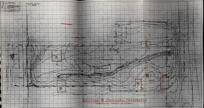 EXISTING & ORIGINAL TOPOGRAPHY
 MODEL OF VIRGINIA GAZETTE BUILDINGS, FROM EVIDENCE.
Footnotes
PRELIMINARY
RESEARCH REPORT
Virginia Gazette Printing Office Site
Colonial Lot 48
VIRGINIA GAZETTE PRINTING OFFICE SITE
Colonial Lot #48
Block 18 #12-B
The Virginia Gazette Printing Office was situated upon colonial lot #48 in the plan of the city of Williams-burg. From York County records, the Virginia Gazette and a few outside sources, it is possible to piece together an incomplete but fairly conclusive history of the Printing Office.
There is no deed recorded at York County to lot #48 before 1719. Tracing the history of lot #47 (west of the lot) and lots 49 and 50 (east of it) it may be inferred that any house that might have been on this site prior to 1719 had been razed or burned prior to this date.
Henry Gill who bought lots 49 and 50 in 1707, received an ordinary license to keep an ordinary at his dwelling house on February, 1708, which he renewed annually, until his death in 1721.
The first deed to lot #48 states:
58January 6, 1719
Trustees City of Williamsburg
to
Archer, Michael
Consideration: 15 shillings.One lot of ground in the city of Williamsburg denoted in the plan of the said city by the figures 48.
Shall build within 24 months one or more good dwelling houses on the lot according to Act of Assembly of 1705.
(Vol. III - Deeds and Bonds. York County, Virginia)
In the next month of the same year, in a deed to lot #47, lot #47 is described as "adjoining on the great street between the store house of Mr. Archibald Blair [lot #46] and the house of Henry Gill". Evidently, no house had as yet been erected, nor by June 15 of the same year, when the same reference was made to the house of Henry Gill.
By February 7, 1721, within the twenty-four months required in the original deed, Michael Archer had erected a house on his lot, according to the deed to lot #47 in which lot #47 is described as being between the "storehouse now in the tenure of Archibald Blair and ye house now in the tenure of Michael Archer".
After Archer's death his widow Joanna, lived in the house for some time, at least until 1729, and perhaps much longer. On May 27, 1737, William Hooper, a merchant, advertised "Just imported, from London, by William Hooper, and to be sold by him at his Store (which was formerly Mrs. Archer's) in Williamsburg, the following Goods, Viz:...".
There are no further references to William Hooper's store, nor to Mrs. Archer's dwelling, even in the sale of her estate in 1745, but the records for the period 1737 to 1745 are very fragmentary.
59It is interesting and pertinent that William Parks first made a proposal to the Virginia Assembly for printing the laws of Virginia in February, 1728. On June 9, 1730, he advertised in his Maryland Gazette that he had just returned from England with printing equipment; by autumn of that same year his advertisements refer to his Printing Office in Williamsburg.
On July 15, 1731, in the American Weekly Mercury of Philadelphia, he proposed publication of a Virginia Miscellany for which he would receive subscriptions "at his House, near the Capitol, in Williamsburg".
In other words, Parks no doubt had a Williamsburg printing office established on some other location by 1731 and when he began publication of the Virginia Gazette on August 6, 1736, he began publication there.
There is another gap in the records from May 27, 1737, (when William Hooper was occupying lot #48) to March 27, 1746, at which time Edmund Pendleton advertised that he had lodgings at Mrs. Pack's [lot #47] next door to the Printing Office. This means that the Printing Office was well enough established on lot #48 to be an identifying landmark.
From that date on there is no question that the Printing Office was located on lot #48.
60In this office Parks not only printed the Virginia Gazette, but printed numerous books, did book binding and sold imported books and stationery.
Parks died in 1750 and left all his property (subject to his debts and other contracts) to his daughter, Eleanor Parks Shelton. Among the debts owed was a debt to Lidderdale & Harmer who sued. This suit forced an auction of the Printing Office at which auction it was purchased by William Hunter:
June 14, 1751.
Armistead, Ellyson - Gent - Sheriff
to
Hunter, William - Printer
Consideration: 131 Pounds(John Lidderdale and John Harmer, surviving partners of Thomas Chamberlayne, deceased, sue John Shelton and Eleanor, his wife, who is daughter of William Parks, to recover certain sums owed by the said Parks to Lidderdale and Harmer.)
Armistead sells and confirms unto Hunter, highest bidder, the printing office and lot which is denoted in the plan of the city of Williamsburg by the figures 48, and is bounded on the South by the Duke of Gloucester Street, on the North by Nicholson Street, on the East by the lot of Mr. John Holt, and on the West by the lot of Mrs. Sarah Packe with the appurtenances.
(Book V - Deeds, York County, Va.)
William Hunter bought the Printing Office, and stock in trade; continued publication of the laws of Virginia, the Virginia Gazette, etc., until his death in 1762.
61He had a minor son, William, to whom he bequeathed "my house and lot in Williamsburg No. 48, where the printing office is now kept", and Joseph Royle was to form a company with his executors to continue the printing business, which he did.
On June 20, 1766, the following advertisement appeared in the Virginia Gazette:
...I beg leave to acquaint my friends and customers that I have just entered into partnership with Mr. John Dixon, in conjunction with whom I have purchased all the materials, stock in trade &c. belonging to the estates of the late William Hunter and Mr. Joseph Royle...
Alex. Purdie.
Purdie & Dixon continued at the Printing Office and on August 17, 1774, John Dixon purchased lot #47 "bound on the East by the lots of William Hunter whereon the Printing Office now stands". On February 13, 1775, he deeded this lot to William Hunter who then owned both 47 and 48.
William Hunter deeded to Elizabeth Reynolds, his mother, a small portion facing Nicholson Street of lot #48 on June 10, 1777, where a small house was erected.
William Hunter was a loyalist and supplied information to the British and in 1781 joined the army of Lord Cornwallis. His property was confiscated, and he applied to the Crown for compensation. The following is a portion of his loyalist claim referring to lots 47 and 48: 62
Virginia
Wm. Hunter
6th Septr 1784
No. 2 Sugar Loaf Court
Leadenhall Street
Attended 28th Septr. 84.PUBLIC RECORD OFFICE (SEAL)
No. 1An Estimate of Losses sustained by William Hunter in Consequence of his Loyalty and Attachment to his Majesty and Government, viz.
(Public Record Office, London Audit Office 13, Bundle 31)
Virginia Currency 1 House and Lott in the City of Williamsburg N47 £650 1 Ditto Ditto N 48 650 1 Ditto Ditto 350 1 Small Farm near Williamsburg 105 4 Negro Men value £75 each 300 5 Negro Women £60 each 300 6 Negro Children from 2 to 10 Years old, average £30 each 180 1 Phaeton & pair Horses in Value 175 1 Waggon & 4 Horses 170 63 20 Head of Cattle, 30 Head of Sheep, and a Number of Hogs in value about £100 Household & Kitchen Furniture in Value about 500 Ditto due on Account of his Business 1200 1 Sloop of 40 Tons 60 1 Sett of Printing Materials 300 A small Quantity of Merchandise in value about 100 £ 5135.
After 1785 the two lots were charged on the Williamsburg tax books to William Hunter's estate. In 1801 Robert Greenhow was charged with one lot "via Hunter" and another was so charged in 1805.
As far as the lots can be traced through the tax books, the building remained in existence, became the property of Robert Anderson and at his death was sold in the sale of his estate. At the time of the War Between the States Mr. John S. Charles in his "Recollections of Williamsburg" describes the old printing office:
On the southwest corner of the square bounded by Duke of Gloucester, Nicholson, Colonial and Botetourt streets, there was a long rambling, two story frame dwelling 64 with three doors opening out upon Duke of Gloucester street. The upper story of this house had a small platform with railing around it, with steps down to the street; the other two doors were reached by steps directly from the street.
To the east of the house just described and separated from it by a narrow alley, was a very old story and a half frame house with dormer windows and two doors opening on Duke of Gloucester street, and on a level with it. Tradition has it, and it seems now to be regarded as established fact, that the first newspaper to publish the Declaration of Independence was printed in this house. The front doors were on a level with the street, and the back door was about ten feet from the ground. At this point the back-bone of this peninsula seems to have been intersected by a ravine running north and south, and it is plainly seen that Duke of Gloucester street is filled in here, and a retaining wall built from the eastern to the western side of this depression, along which now runs a railing to protect pedestrians from injury.
The old house referred to was used, in the writer's day, one end for a shoe shop and the other for a grocery and dram shop. The retaining wall extended, within the writer's memory, about two feet above the sidewalk and was used as a loafers' retreat, where they gathered and after imbibing, sat on this wall and ate hard crabs, which were then peddled around the streets. The shells from the crabs being left on the ground along this wall, caust it to be known as Fort Crab.
The first deed in the Williamsburg court records to this property is dated October 26, 1876, at which time Joseph M. Walthall executed a homestead deed upon a house and lot then occupied by him as a store. According to Mrs. Victoria Lee in her notes in "Williamsburg in 1861" 65 Walthall had a shoe shop in this building at that time:
...Just west of this building was a frame, story and a half house, also used as a shop.*
After Walthall's death the building was owned by his widow until September 10, 1892, when she deeded it to Delia P. Braithwaite. A photograph in the Coleman Collection, made in 1881 shows the building as it appeared at that time.** There is every reason to suppose from the extant evidence that this building is the one which had been used as a printing office by Parks and his successors.
According to Lyon G. Tyler, this building and most of the other old buildings on this lot were totally destroyed by fire in March, 1896:
...William Hunter's old frame residence of a story and a half, and a small printing office (the old printing office was standing as late as 1896 when the square of old houses in which it stood was entirely destroyed by fire.
Delia P. Braithwaite conveyed the lot to William B. and Virginia B. Braithwaite from whom it passed to the present owner, Virginia Braithwaite Haughwout. A store 66 owned by these late owners burned also.
One significant fact which may account for certain archaeological evidences on the site, is the location of the deep ravine which at one time may have created a depression in the Duke of Gloucester Street. The General Assembly on several occasions appropriated money to improve the streets of Williamsburg and in 1724 the Reverend Hugh Jones in his Present State of Virginia wrote, "...but to make the main Street exactly level, the Assembly lately gave a considerable Sum, which was expended in removing Earth in some Places, and building a Bridge over a low Channel, so that it is now a pleasant, long dry walk, broad, and almost level from the College to the Capitol"...
The Reverend Jones refers, no doubt, to an appropriation of L150 made by the General Assembly, November 30, 1720, "for making Bridges & Cause ways in the principal street of the City of Williamsburg." This appropriation had been spent by May 9, 1722, at which time the Committee for Public Claims examined the accounts.
It is conceivable that some of the brick work on the site may be a retaining wall or other feature of this street work.
67This report, compiled after archaeological excavation or other key properties in the same square supersedes the previous report.
Department of Research and Record
Report by: Helen Bullock
Copies to:
Mr. Geddy
Architectural Department
SIZES OF COLONIAL LOTS
April 12, 1938
The act under which the city of Williamsburg was established and laid out in 1699 was called "An act directing the building the Capitoll and City of Williamsburg." Under this act, Theodorick Bland was named surveyor and a group of trustees were appointed to hold title to the land.
The Theodorick Bland Survey of 1699 is still on record in the Public Records Office, London, and a photostat of this first basic survey is available in the Research Department. After the survey was completed, the town was "regularly laid out," under the direction of the Trustees for building the Capitol and city of Williamsburg. Streets and greens were set aside and the remaining area was divided into half acre lots. The unit used in the Bland survey was the pole (16½ feet), a unit which is readily divisible into acres. The lots on the great street, or Duke of Gloucester Street, were five poles (82½ feet) wide and contained one-half acre or 217,800 21,780?square feet, which gave each lot a depth of 264 feet. This lot depth corresponds to the distance between Duke of Gloucester Street line, and the line of Nicholson Street.
69The next step in the development of the city plan was in the numbering of each lot and the recording of the lot numbers on a plan kept in the County Clerk's Office. At least five examples of the Williamsburg lot plans survive and copies of these are also available in photostat or blue print form. Deeds were recorded in the office of the County Clerks of York County or James City County and such records frequently referred to the lots by number. Almost without exception a lot was called a "half acre or portion of ground." Provisions were made that to hold title to the lots the proprietors had to enclose the "Said lots or half acres with a wall, pails, or and rails," and buildings had to be erected within twenty-four months. Among the provisions of the complete act were:
OCTOBER 1705—4th ANNE
XXVII. Provided always, That the building of one house be the dimensions thereof never so large, shall not save more than two lots, or half acres, on the great street; and that whatever lots, or half acres more, the builder is willing to take a grant of, shall be taken backwards.
Lots, when to be inclosed
XXVIII. And be it further enacted, That every person having any lots, or half acres of land, contiguous to the great street, shall inclose the said lots, or half acres, with a wall, pails, or post and rails, within six months after the building, which the law requires to be erected thereupon, shall be 70 finished, upon penalty of forfeiting and paying five shillings a month for every lot or half acres, so long as the same shall remain without a wall, pails, or rails, as aforesaid: To be recovered before any justice of the peace of York or James City county, upon the complaint of any one of the trustees or directors, and to be disposed of by the directors as they shall think fit, for the use and benefit of the said city and ports thereunto belonging.
Proviso as to lots formerly laid out
XXIX. And be it further enacted, by the authority aforesaid, and it is hereby enacted, That none of the lots, or half acres of land in the city of Williamsburg, whereon any houses were standing, at the laying out of the said city, shall vest in the said feoffees and trustees of the said city, to be disposed of, as the rest of the lots, and half acres may be, by virtue of the said act, made at a general assembly begun at James City, the twenty-seventh day of April, one thousant six hundred ninety-nine, intitutled, An act directing the building the capitol, and the city of Williamsburg; but that all and every of the said lots and half acres, shall remain and continue the proper estate of the respective proprietors unaltered by the said act, and so shall be adjudged, deemed, and taken; any thing in the said act to the contrary, or seeming to the contrary, notwithstanding.
(Hening's Statutes at Large, Vol 3, p.430)
The boundaries were well defined and law suits over encroachments as small as six inches occurred. Encroachments upon the public street or over an adjoining neighbor's line were not permitted as long as the capitol remained in Williamsburg. And, although some colonial lots were sub-divided in the eighteenth century, the majority of such divisions occurred in the nineteenth and twentieth centuries. Even allowing for changes brought 71 about by the sub-division of properties the present-day lot lines very frequently have an old established line for at least one boundary.
The York records, which contain deeds to all Williamsburg property recorded there between 1699 and 1813, substantiate that lots were regarded as units containing a half acre, having 82½ feet front. In instances where sub-divisions occurred the units were referred to as "portions or dividends of lots."
In the case of colonial lot #48, on which the printing office stood, the above sources indicate that it contained 82½ front feet. Its boundaries were described in one deed dated June 14, 1751:
...the printing office and lot which is denoted in the plan of the city of Williamsburg by the figures 48, and is bounded on the South by the Duke of Gloucester Street, on the North by Nicholson Street, and on the East by the lot of Mr. John Holt, and on the West by the lot of Mrs. Sarah Packe with the appurtenances... (Book V - Deeds, York County, Virginia)
Prior deeds refer to the lot by number, and not until William Hunter on June 10, 1777, gave his mother a life interest in a portion of the lot, were any subdivisions of it recorded. On all the town plans after that date lots 47 and 48 are marked "Hunter." After 72 they were sold by Hunter's estate in the first quarter of the nineteenth century, the lots were subdivided many times. A present-day plat of colonial lot #48 includes property traceable to three parcels, but none of them were separate in the eighteenth century.
Department of Research and Record
By
Helen Bullock
10:21