William Waters House Archaeological Report, Block 18-2 Building 2A Lot 50Originally entitled: "Foundations of Waters-Coleman House - Waters-Cowan House, etc. Colonial Lot #50"
1933
Colonial Williamsburg Foundation Library Research Report Series - 1384
Colonial Williamsburg Foundation Library
Williamsburg, Virginia
1990
To: H. R. Shurtleff, Director of Research & Record Department.
From: H. S. Ragland.
Subject: Foundations of Waters-Coleman House - Waters-Cowan House, etc. Colonial Lot # 50, site of recently razed James City Furniture Company Building.
Date: August 9, 1933.
See drawing- Block 18 - Area G.
Submitted herewith is an archaeological drawing showing foundations recently uncovered at the above described site.
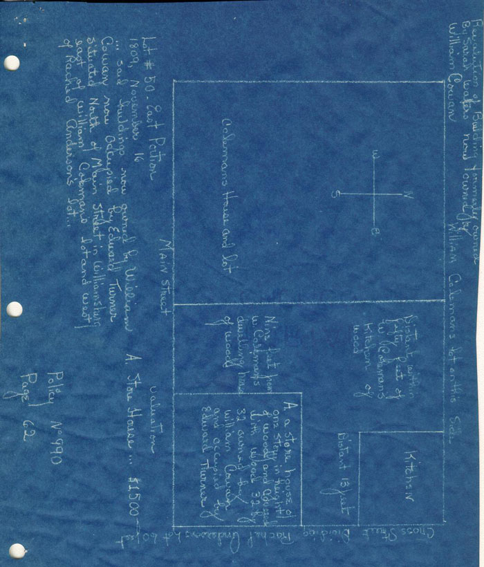
Two colonial foundations, one built over the other, were found on the western part of the lot. Both had deep basements. Apparently, the oldest, "A", is the foundation of Robert Davidson's House (See research report). The basement paving shown on the drawing belonged to this house, "A", for it is below the bottom of the footings of the second colonial house, "B".
The second house "B", was probably built about the middle of the 18th century, probably by William Waters, as the Waters family owned the property during the latter half of the century. Foundation "B" is, in round numbers 40'x 20', twice as long as it is wide--not the shape of the building shown on the Frenchman's Map of 1786. Foundation "B1" is an addition (or additions) to foundation "B", making the main block of the house, in round numbers, 40'x32', the correct shape and approximate size of the house shown on the Frenchman's Map. Therefore, it seems that "B" was probably built about the middle of the 18th century as the addition "B1" was added to it prior to 1786. Wm. Coleman owned
2
the property in 1806 and "B" including "B1" is undoubtedly the house he insured, for it is recorded in his policy that the size of his house was 42'x 33'. The rear wing of "B1" is 12'x 15', with an interior wall, running east and west, dividing it into two portions 12'x 8' and 12'x 7'. Wm. Coleman's insurance policy shows that his house had a porch on the rear 12'x 8', which indicates that the addition 12'x 15' was probably built in the 18th century and later removed, being replaced by the 12' x 8' porch, which existed in 1806.
Only two walls (the north and the west) of a colonial foundation were found at "C". The other foundations of "C" were evidently destroyed to make room for the foundations of the recently razed building, last occupied by the James City Furniture Company--See drawing.
At "C 1" remains of an addition to "C" were found. Assuming that the front wall of "C" was in line with the front wall of "B" and the east wall of "C" was on the colonial west line of Botetourt Street, the whole building "C" including "C 1" was approximately square, measuring 34'x 32'. As the Frenchman's Map shows a square building approximately that size both "C" and "C 1" were probably built prior to 1786. At "C" is evidently older than "C 1", "C" was probably built as early as the middle of the 18th century. The Waters family also owned this property during the latter half of the 18th century. Wm. Cowann owned the property in 1809 and insured a house, formerly insured by Sarah Waters, and evidently the same building, "C" including "C 1", for the size recorded in the policy is 32'x 32'.
3The Frenchman's Map shows an outbuilding approximately at "D", which indicates that foundation found there was built prior to 1786. It looks like a chimney or foundation for entrance steps and landing platform. However, as Wm. Cowan's insurance policy of 1809 shows that his kitchen was approximately at that location, foundation "D" was probably the base for steps and landing platform at a door, as it is rather small for the usual colonial kitchen chimney.
Foundation "E" is undoubtedly the foundation of Wm. Coleman's kitchen, insured in 1806, for it is recorded in his policy that his kitchen was 27'x 17', one story high, with wooden shed 27' x 10'. The south portion of foundation "E" including a very large chimney is 26'x 17', evidently the kitchen proper, and the north portion of the foundation is 26'x 10', evidently the shed portion of the building. This kitchen was very probably also the Water's family Kitchen, as the brickwork is undoubtedly colonial --English bond, and oyster shell mortar. The Frenchman's Map shows, at the location an outline indicating also that a building stood there prior to 1786.
Foundations A, B, B 1, C, C 1, D, E and F are all built in English bond with oyster shell mortar. Brick sizes are shown on the drawing.
The brick drain shown on the drawing is colonial, and probably was built during the first half of the 18th century, for the rear wing of "B 1" is built over it. The drain was broken-off and stops near the N.W. corner of foundation "B 1", evidently having been removed beyond that point to make room for the modern brick cement plastered cistern found there (See drawing). The drain began east of the west line of Botetourt Street, and, as no inlets were found on this property
4
(colonial lot # 50), may have drained the Prentis lot across Botetourt street or perhaps the ditches of Botetourt Street. It flows westwardly and probably emptied in the ravine about a hundred feet west of the cistern.
A well was found in the rear of the lot near Botetourt Street, but no brickwork was uncovered, (See drawing). The lot was not completely excavated because of the limited amount of money authorized for archaeological excavation of the site and the fact that the foundations were deep. The excavations were made in such a manner as to secure first the essential information if possible, the plan and principal dimensions of any foundation found. When walls were found they were followed and uncovered in places, but all the fill in the basement and between walls was not removed.
Buildings "A", "B", B 1" "C" and "C 1" all had basements. Fragments of paving of basement "A" were found. The basement floor levels for the other buildings could not be determined.
At "F" in the rear part of the western portion of the lot, foundation of a smoke house was found. In the center of it, a small square brick fire-box was found.
See drawing - Block 18 Area G.
Herbert S. Ragland.
COLONIAL LOT # 50 - "William Cowan" Block 18, # 1 (2). June 18, 1932
DIGEST OF DATA
Shop:
One story with dormers, 32 x 38 feet on corner of Botetourt and Duke of Gloucester Streets nine feet from house on West. Kitchen South of building on Botetourt Street. May have been built 1709-1736, determinable by excavation is at least prior to 1786.
An apothecary shop may have been built on this lot between 1709 and 1736. In 1736 William Parks had established his printing office in the block which made this area an important one.
The shop was advertised in the Gazette:
"June 17, 1737. All Sorts of Balsams, Decoctions, Electuaries, Elixirs, Emplaisters, Extracts, Infusions, Liquors, Magisteries, Oils,..., faithfully prepared and Sold by Robert Davidson and Thomas Goodwin, Chymist, at Williamsburg."(Virginia Gazette - William Parks, Ed.)
When Robert Davidson died he bequesthed his property to his wife Mary. He had a large house on the lot and it is only possible to determine by archaeological examination whether Davidson's shop was in the house or in a separate building. The assumption, since a separate building was on the site at a later date, is that it was this early apothecary shop.
The property transferred, with the western portion of its lot, and with lot # 49 on the west through two owners to William Waters. His wife Sarah, and daughter Sarah next owned it, and it was Sarah Waters who sold a shop on the
2
eastern portion of lot # 50 to William Cowan.
The building shows on the Frenchman's map of 1786 so it had been built prior to that date even if it was not the Davidson shop of 1736. Cowan insured the shop in 1809, a tracing of the insurance policy accompanies this report.
Harold R. Shurtleff, Director Department of Research & Record.
Report by: Helen Bullock
HB/vbl
cc: P. S. & H., Wmsburg and Boston
Dr. W. A. R. Goodwin
A. A. S.
enc: