Golden Ball Archaeological Report, Block 17Originally entitled: " Archaeological Report,
Area F, Block 17 (Rear of Golden Ball)"
Colonial Williamsburg Foundation Library Research Report Series - 1360
Colonial Williamsburg Foundation Library
Williamsburg, Virginia
1990
ARCHAEOLOGICAL REPORT
Area F, Block 17 (Rear of Golden Ball)
September 7, 1939
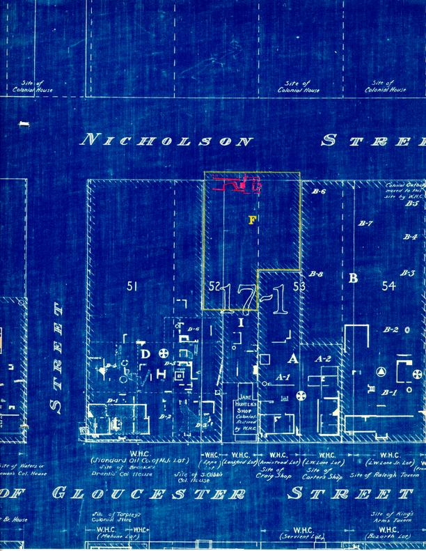
Early in 1939 an area was excavated which included the northeast corner of Colonial Lot #52 and the northwest corner of Lot #53. No outbuilding foundations came to light, although one or more had appeared in this area on the Frenchman's Map. Instead, a foundation which appears to represent a dwelling house was discovered in the northwest portion of the area, i.e., in the northeast corner of Lot #52, directly behind the Golden Ball.
It has so far been impossible to locate exactly and finally the lines of colonial lots in this area. If the assumed lines are correct, this foundation encroaches on Lot #53 to the east and Nicholson Street to the north.
The earliest part of the foundation is outlined by two 13-inch basement walls running east and west, which fix the width of the building at slightly over 12 feet. No end wall was found on the west. The evidence seems to indicate that, instead of a basement retaining wall at this end, there was an earth bank with a light foundation wall above it, near grade level.
To eastward is a short length of 9-inch north-south basement wall of early date, which probably locates the end of the original building. A short buttress-like projection, which carries the line of the north foundation wall about a foot beyond the corner, is unexplained. Also unexplained is a section of brickwork of the same period, near grade level and two courses deep, which forms a sort of floor - above, and outside of, the early section of end wall.
This 2-course fragment, with the wall under it, is cut off on the south on a 45-degree angle which seems too regularly defined to be accidental, but which is unexplained.
| Brick | 8½ x 4 x 2-5/8, English bond. |
| Mortar | Shell. |
| Condition | Fragmentary. |
BASEMENT PLAN
The basement walls begin about 3½ feet below present 2 grade. No traces of paving were found.
The south wall has a gap in its middle, over 8 feet long. The outside grade extends through this gap into the basement area to form a sort of island of an irregularly quadrilateral shape. This "island" is held by three 9-inch retaining walls inside the basement, of which only the one to westward is parallel with an outside wall: the others make obtuse interior angles, and the east wall returns to the south outside wall at almost a 45-degree angle. The top of this east wall has fallen over into the basement.
These walls are not bonded in with the outside wall. The soil inside them has never been excavated.
The "island" divides the basement into two relatively small end areas, leaving only a passageway on the north, shaped like a blunted wedge, which at the narrowest is scarcely over 3 feet wide. Undoubtedly the separation of the two ends had some purpose connected with the use for which the basement was intended, for a full basement with continuous outside walls would have been much easier to construct. But what the intended purpose was can only be conjectured.
| Brick | 8¼ x 3-7/8 x 2-5/8 |
| Mortar | Shell. |
| Condition | Fair. |
EAST OUTBUILDING
East of this foundation and nearly centered on it, are traces of three walls and two corners which appear to have belonged to an outbuilding of an early period. Three or four loose bricks on the east may represent the fourth wall. The north and south walls are parallel, but the corners are not right angles. The two extant courses are slightly below grade level.
| Brick | 9½ x 4-3/8 x 2½, English bond. |
| Mortar | Shell. |
| Condition | Poor. |
STEPS AT NORTHWEST
North of the northwest corner was uncovered a fragmentary foundation which seems to have the form of a basement entrance, although the house wall here rises nearly two feet above its base.
STEPS AT NORTHEAST
North of the northeast corner was found a filled-in area about 6 feet square. Here there is a gap in the north house wall, which appears to have turned north to flank the fill on its western edge. On the eastern edge of the fill there remains a length of 9-inch foundation wall, 2 courses deep, which has the characteristics of early brickwork. The line of this 9-inch wall seems to lie to eastward of the end of the building.
The gap in the foundation wall might be taken as strong evidence that these were basement steps. But several questions remain unanswered:
- 1Why would so small a house have two basement entrances?
- 2Why is there no trace of a first-floor entrance?
- 3If the steps were partly to eastward of the building, were they put in after the building itself was extended to eastward?1 The character of the brickwork in the various walls does not seem to support such a supposition.
It seems possible that this area was used as a drainage pocket, rather than for entrance steps.
EAST EXTENSION, SECOND PERIOD
The original building seems to have been prolonged by a later addition to eastward on 9-inch brick foundations, beginning just below grade, which continued the outside lines of the older structure. Evidences remain of the north and south walls, northeast corner, and chimney. The chimney is built on the original 4 clay, the walls (for most of their length) on fill. The fill is the main proof that these foundations are later than the basement walls. The brickwork has much the same character as that of the basement.
The chimney is only about 5 feet wide, the fireplace 3 feet. The chimney projected about 1 foot outside the house, the fireplace 2 feet inside.
| Brick | 8¼ x 4 x 2-5/8, English bond. |
| Mortar | Shell. |
| Condition | Fragmentary. |
EAST FOUNDATION, THIRD PERIOD
No evidences were found of a chimney to the original house. But there is a large foundation, centered on the east end of the original house, which seems to represent a chimney of late date,1 and which might have displaced an earlier chimney.
This foundation is of the period of 9-inch wall foundations which form an irregular square, about 16 feet on a side, to east of it. If this was a dwelling, it may have been continued, towards the west; for two detached lengths of 9-inch brickwork were found west of the northwest corner, on the line of the north wall.
The late date of this construction is attested by its lime mortar, and by the fact that, at several points, it crosses over the foundations already described.
Three lengths of north-south foundation wall of the same period, east of center of the square foundation, are unexplained.
| Brick | Size varies. Common bond. |
| Mortar | Lime. |
| Condition | Fragmentary. |
CHRONOLOGICAL SUMMARY
There is no evidence to determine the original date of this foundation. But it seems evident that the building of the first period was lengthened by that of the second period,1 while this lengthened building had disappeared when the dwelling of the third period was constructed. No building is shown on this site on the Frenchman's map of c1786, and it may be that at this time the first dwelling had disappeared and the second was yet to be built.
There is a possibility that the original house on this site is still standing on another street.
The Patsy Custis or "Wigmaker's" House, on the north end of Colonial Lot #22, was moved to its present site from Colonial Lots #272 and #273.2 These lots lie across Nicholson Street from Lot #52, and a short distance to eastward.
The Patsy Custis house has a width of 12 feet 3 inches at the foundation, and 12 feet 5 inches above. That a house so unusually narrow should correspond so exactly in width to the foundation of Lot #523 would seem to be more than a coincidence.
The length of the Patsy Custis house is 43 feet. The lengthened foundation of Lot #52 seems to have been 45 or 46 feet long.
This chain of evidence suggests that the house of Lot #52 may have been moved, first to Lot #2724, and later to Lot #22. If so, it must have been shortened by 2 or 3 feet in connection with one or both of the moving operations.
It is recommended that
- 1.Fragments from this site be carefully investigated for any information they may contain as to the dates of the various segments of the foundation, and
- 2The Patsy Custis House be examined to verify whether 6 it shows evidences of having been built at two periods and subsequently shortened.1
- 3The possibility be investigated that this remarkably shaped basement may have been intended for use in the manufacture of gunpowder or other explosives. This might explain the solid dividing island, and perhaps the wedge shape of the passageway.
Footnotes
SOURCES
- 1. Fragments:
In the west end of the cellar were found many small bricks, bats, fragments of mortar, and some old broken bottles. The east end produced some brickbats and assorted household rubbish.
No fragments of interest were found under the east addition.
Fragments have been deposited with the Educational Department.
- 2.Photographs:
- N 5931 Foundation from southwest
- N 5932 Foundation from northwest
- N 5936 Foundation from southeast
Points from which these pictures were taken are shown on the Archaeological Survey drawing.
Prints are deposited in record books in the offices of Williamsburg Restoration, Inc.
- 3.Archaeological Field Notes
In separate file.
- 4.Archaeological Survey Drawing
A print is incorporated with the original of this report.
- 5.Suggested Names for Williamsburg Buildings, Report of Harold R. Shurtleff, January 12, 1934.
A copy is filed with the original of this report.
F. D.
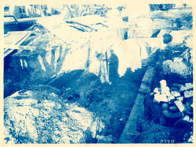 Photograph N5931
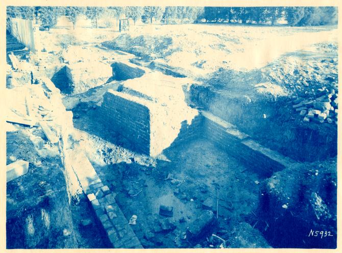 Photograph N5932
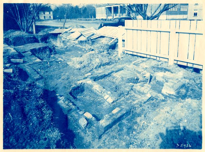 Photograph N5936
Plans in rear pocket of Rockefeller Library's bound version - no digital images available