Alexander Craig House Archaeological Report,
Block
17 Building 5 Lot 55 Area GOriginally entitled: "Vaiden House Site"
Colonial Williamsburg Foundation Library Research Report Series -
1345
Colonial Williamsburg Foundation Library
Williamsburg, Virginia
1990
ARCHAEOLOGICAL REPORT
VAIDEN HOUSE SITE
COLONIAL LOT 55
(BLOCK 17, PART OF AREA G)
CONTENTS
- CHRONOLOGICAL SUMMARY
- GENERAL DESCRIPTIONS
- DETAILED DESCRIPTIONS
- NOTES
- SOURCES
- SECTION OF ARCHAEOLOGICAL KEY MAP
- CHRONOLOGICAL PLOT PLAN - DATE
- ARCHAEOLOGICAL DRAWING: VAIDEN HOUSE SITE, AUGUST 1941
CHRONOLOGICAL SUMMARY
(Purchasers named in the deeds, whose ownership was temporary or never fully established, are omitted from the following list.)
| £150 | 1712 | Lot 55, previously owned by Jacob Flournoy, bought by Susannah Allen, "with . . . houses, buildings . . . " |
| 1716 | Tavern licensed by Susannah Allen | |
| 1717 | Lot 56, previously owned by Wm. Wharton, bought by John Marot, with "mansion or dwelling house . . . " | |
| £100 | 1735 | Lot 55 bought by John White, who sold southeast corner to John Wagnon. Wagnon built a small wigshop. |
| 1736 | Andrew Anderson, wigmaker, bought the wigshop. | |
| £40 | 1737 | John Pasteur, "barber and peruke maker," bought balance of lot 55. |
| £40 | 1738 | Gabriel Maupin, "tavern keeper," bought Pasteur's holding. |
| 1745 | A 30-foot strip forming the western part of lot 56 "and all horses, buildings ..." was deeded to James Shields - "ordinary keeper" and husband of Anne Marot. | |
| £100 | 1752 | Wm. Peake bought the wigshop, which had been improved and probably enlarged by Anderson, and carried on the business. |
| £87 | 1755 | Peake sold the shop to Alexander Craig, "sadler". |
| 1762 | Joseph Scrivener, "merchant" bought Shields' 30-foot strip," whereon is a storehouse and other outhouses ...and all houses, outhouses, buildings ..." | |
| 1771 | Craig buys Maupin's tract, giving him sole ownership of lot 55. | |
| 1772 | Scrivener's death. Inventory indicates stock in trade. No further definite information until recent times. | |
| 1776 | Craig's death. His will is the last definite information until recent times. | |
| 2 | ||
| 1786(?) | The Frenchman's map shows, east of the Raleigh Tavern, a small building which might be a survival from Susannah Allen's tavern (at least it is near the probable location of the tavern), and a large building which might be the structure later known as the Vaiden House. The next structure might represent the Scrivener Shop, though it is very small indeed. Future investigations on the site of the Victoria Lee House may confirm or cast doubt upon this chain of identities. | |
| c1800 | Real estate plats show "Galt" in lot 55 and "Greenhow" in lot 56. But a chain of evidence drawn from insurance policies of 1802-1815 points to the conclusion that Galt occupied not only lot 55 but also about two-thirds of lot 56, leaving only the eastern third to Greenhow. If this is the true conclusion, then Greenhow's name does not properly appear in the history of archaeological area G. | |
| Later records of the exact year are not available — the Galt property seems to have passed into the hands of the Barlow and later of the Vaiden family. It is not certain that there was not an intervening owner. Miss Vaiden states that her grandfather, Mr. Barlow, bought the house as a young man (c18402), and opened store after remodeling the southeast front. | ||
NOTE: See Chronological Plot Plan herewith.
GENERAL DESCRIPTIONS
The exact location of Colonial Lot lines in Block 17 constitutes a long-vexed problem. Lot lines on the spacing of 82½ feet (standard in Colonial Williamsburg) have been applied to the plan of Block 17, using several points of departure. But every system of lines so laid down involves contradictions within itself.
At the west end of Blocks 9 and 17, the Waddill survey of 1929 shows two east lines for Botetourt Street, a modern line and - six feet east of it1 - a Colonial one. But lot lines derived from this latter street line conflict with the known sites of several early buildings2.
The west end of the Waters - Coleman foundation in Block 18 may be taken as the Colonial line between lots 49 and 50. Starting from this line, and allowing 66 feet for Botetourt Street, several lot lines in Block 17 still present difficulties.3
Only one Colonial line in Block 17 can be located by direct evidence. This is the line between lots 57 and 58. Records of a lawsuit of 17434 show that this line (located then by actual survey) was about eight feet east of the west end of Burdette's ordinary. The foundation of the ordinary has been uncovered, and thus the line can be located with reasonable confidence, yet other lines derived from this one raise several serious problems.5
Apparently any consistent theory of lot lines in this block must involve more or less serious contradictions, and it can only be concluded that the lines themselves must have been inconsistent.
There is little doubt that the Prentis house encroached on the public street until the street's width was reduced, and no doubt that the 4 location of Burdette's Ordinary constituted a trespass. Possible causes of other conflicts are improperly recorded transfers and carelessness or incompetence in laying out the lots.
Pending future excavation (now impossible) in the Lee and Armistead lots, no further conclusions seem justified for the block as a whole.
The Vaiden property occupied 117.35 feet eastward from the east end of the Raleigh Tavern—probably the whole of Colonial lot 55, plus the west portion of lot 56. The archaeological exploration of 1939-40 covered the entire property.
Lot 55 was never subdivided, except that one small "dividend" in the southeast corner was sold in 1735, but reunited with the property in 1771.
Lot 56 was divided, subdivided, and partly reassembled at a later date. But a strip on the west eventually remained part of the Vaiden property. This strip, under the name of the Scrivener site, became part of Archaeological Area G.
The present report is concerned only with the Vaiden site, which is believed to correspond closely with Colonial lot 55.
The excavated west portion of Colonial lot 56 is considered in the Scrivener archaeological report (August , 1941).
DETAILED DESCRIPTIONS
Foundations are located by reference letters on 1/4" scale Archaeological Drawing.
"A" An extensive area of paving was found inside the Vaiden house foundation at the west end. It was at a deep level, more than two feet below the basement floor of the house. It appeared to extend farther west under the southwest chimney and into Area "B", but it was not possible to dig close enough to the chimney to verify this. It probably did not extend very far in this direction, for hardpan was found near the surface just west of the chimney. The total size of the foundation here indicated was probably not over 16 x 20 feet.
Stretches of a soldier course at the edge of the paving seem to be remnants of the original foundation wall. At the northeast corner this foundation has the form of a re-entrant angle.
This foundation is clearly older than the house, under a chimney of which it is partly located. Its location with reference to the tavern in the southwest corner of the lot "B", as well as its small size, indicates that it is older than the tavern (with which none of its walls coincided according to the available evidence.)
One possibility is that this foundation is that of the cellar of a dwelling which might have been built by Flournoy before 1712, to establish possession of the lot
| Brick 9" x 4 ¾" x 3". | Light buff |
| Mortar | Shell |
| Condition | Bad |
Second Period
"B" The traces excavated indicate a 9-inch brick foundation at grade level, 20 feet across from north to south and of unknown length (Photograph N6121). A short length of 9-inch brickwork on the west (b1) may indicate the end of the building: it is six feet from the end of the Raleigh Tavern. No indications of corners were found. The chimney foundation (b2) (Photographs N6119,6148) is against the north wall, on the inside. The shape of one fire-place, facing south of west, is partially outlined. Another probably existed opposite it, facing south of east. It is possible, although unlikely, that a fireplace also existed on the south or north side of the chimney or even both, but evidence is lacking.
East of the chimney is a 9-inch retaining wall (b3). Its purpose is not known, but it is close to the probable west edge of the first-period cellar excavation, and might have been intended to reduce the chances of a cave-in if the older cellar was open at the time when the later chimney was built.
Due south of the chimney, outside the south or street-front wall, are three 9-inch foundation walls (b4) which might form the outline of an entrance stoop or porch (Photograph N6118).
If the chimney and stoop can be taken as the center of the building, and if the presumptive west wall foundation is the true one, then the building was forty feet or more in length. All direct evidence of the eastern portion disappeared with the placing of the later Vaiden house foundations. But there can be no doubt that the two sites overlap. Otherwise there would be no accounting for the shape and location of the chimney of "A" or for the fact that the north wall of "A" is cut off by the west wall of the main house.
7Small patches of broken brickwork near the southwest and northwest corners, and across the stoop foundation, probably represent late exterior paving. The same explanation may account for a layer of marl and crushed brick found north of the stoop.
Since this was the last building standing on the street-front of lot 55 before the Vaiden house, it may be conjectured (but without direct evidence) that Susannah Allen's tavern stood here. The tavern might have had two rooms below and two above stairs, without regard to possible rear additions. Considering the location of the chimney, the heating of upstairs rooms would seem to have presented a problem if the building was of 1½ stories.
| Brick size | 2 ¼" x 4 ¾" x 2 ¾" |
| Color | Reddish Buff |
| Mortar | Shell |
| Condition | Fair |
| Bond | English |
"C" (Outbuilding north of "B": N6120,6123).
At the northwest corner of the Vaiden house is a cellar foundation ("C") 16 by 16 feet in size, with brick paving about half of which has been preserved. Of the bulkhead type steps (C1) at the center of the east wall, enough remains to indicate the entire original construction, with wood nosings and brick flanking walls. Only one short stretch (C2) of original wall foundation remains. The remainder, however, was clearly indicated by fill.
The basement floor was 3 feet below the original grade and 4 feet below the modern grade, which has been raised by fill. Foundation "C" centers on the stoop and chimney of the tavern. It could have been a separate structure, or it could have been the north end of a wing (forming the leg of a T plan). In the latter case the chimney of "B" seems well located for passageway to the wing on the 8 first floor (but not the second), and seems well located for heating up to three rooms (to east, west, and north) on the first floor.
However, the Frenchman's map (1786?) shows, apparently in this location, a small building set well back from the street.9 Such a building would fit "C" better than any other foundation in the area. If it is in fact the same as "C", the most probable inference is that this was a free-standing building, which survived after the tavern in front of it was pulled down as the Vaiden house grew larger.
There is no evidence of a chimney, but an exterior chimney might have stood at grade level. The use of the building can only be conjectured. The location would be suitable for a kitchen.
| Brick | 9 ¼" x 4½" x 2 ¾" |
| Color | Buff |
| Condition | Fair |
| Bond | Flemish |
Vaiden House ("D").
The name is not a Colonial one (see Chronological Summary), but is used here because of the uncertainty as to the sequence of Colonial owners in relation to various stages of the building.
The rectangular mass was built up during Colonial times in four or five instalments, the general sequence of which can be deduced from archaeological evidence weighed against historical evidence. The early building was of 1½ stories in front, with a shed to the rear. Later a full second floor was built. Other late additions were three sheds on the north and a two-storied porch on the south.
Southeast Room (Photographs SM 1V, 2V, 3V)
The earliest part of the structure was at this corner. It can be 9 dated with reasonable confidence during the short occupancy of Wagnon, since this owner bought the property for 15 pounds and sold it for 40 pounds.
The foundation wall is of brick, 13 inches thick. It measures 16 feet from north to south and 19 feet from east to west. The north wall (d1) follows a line of feet back from the street line. The line of the east wall (d2) may be taken as the east property line.11 Thus this foundation gives every evidence of being confined within the original "dividend" of 20 by 24 feet, in the southeast corner of lot 55. No doubt, therefore, this is the original foundation of the wigshop.
The entire area is excavated for a basement. There is no evidence of paving.
The chimney (d3) (Photograph SM2V) is an inside one at the northeast corner and also serves the rooms to the north. It seems clear from other evidence that the two rooms were built at different times, but the chimney and east wall show no evidence of a joint. It may be conjectured that the chimney and east wall of this room were rebuilt as a whole when the north room was built. There is no evidence whether there was a usable fireplace at the basement level.
At different dates there were two basement entrances to this space in the south wall (d4). Each one of them was eventually bricked up. Indications are wing walls outside the foundation (N6144), and vertical joints in the wall itself (Photographs N6144, SM3V).
| Brick | 8" to 8 ¼" x 3 ¾" x 2 5/8" |
| Color | Reddish Buff |
| Mortar | Shell |
| Condition | Good |
| Bond | English and Common |
South Central Room (Photographs SM 5V, 7V, 8V).
The first addition to the Wagnon shop was either the room to the west in this report referred to as ("South Central") or that to the north referred to as ("Northeast"), probably the former.12
It is uncertain whether the south central room could have been built before Craig's purchase (in 1771) of this part of lot 55. No additions to the Wagnon tract are recorded before that time. On the other hand, there are two indications that Anderson (owner, 1736-1752) probably enlarged the structure: first, he bought for 40 pounds and sold for 100 pounds; and second, his long occupancy (it lasted 17 years) argues a successful business.
If this room was added by Anderson, its date is put back to 1752 or earlier. But in order to add to the building, he must have acquired more property. No records of such acquisition are known to exist at present, but this fact does not justify the drawing of any conclusions.
The 9-inch south wall (d5) appears to have turned at the southwest corner of the room, but no evidence remains of the original west wall itself. The east end of the south wall butts against the outside corner (d6) of the southeast room (Photograph SM7V). Near this corner the heavy foundations of a stoop (d7) gives evidence of an early first-floor entrance (Photographs N6142, 6143).
| Brick | 8½" to 8 ¾" x 4" x 2½" |
| Color | Salmon Red |
| Mortar | Shell |
| Condition | Fair |
Farther west and overlapping is the 13-inch foundation of a later entrance (d8). It is located near the center of the wall, and on the center line of a rear entrance foundation of the same period. (See below, "North Central Room").
11| Brick | 9" x 4" x 2½" and brick bats |
| Mortar | Shell |
| Condition | Fair |
The 13-inch west (d9) and north (d10) walls are probably later, perhaps replacements of the period of the latest (northwest) addition. But the west wall is near the line of the earlier wall which it replaced, and which can be located by the early southwest corner visible in the south wall.
The north wall ends on the east with a butt joint (d11). (See note 12 and Photographs 5V, 6V.)
| Brick | 8 ¼" x 4" x 2 5/8" |
| Mortar | Shell |
| Condition | Good |
This space was not originally excavated, as may be seen by the manner in which the original 9-inch south wall has been underpinned with 13-inch work (Photographs SM7V, 8V). The excavation was done when one of the later additions was made, and the west and north walls (presumably 9 inches thick originally) were replaced with walls 12" thick. The location of the original 9" north wall may be deduced with reasonable certainty by assuming that the new 13" wall would probably have its north face 4" farther north, to provide bearing for the new joists. Hence the south face of the new wall would probably be on the old line.
Northeast Room
It is not certainly known whether the next addition was the southwest or the northeast room. However, with the building of the southwest room, the Susannah Allen Tavern must have disappeared, for the two sites overlap. The western portion of the present Vaiden lot remained in separate ownership until 1771 and it seems likely that the tavern was standing until that date. Hence the southwest room was probably not added until 1771 or later. On the other hand, Anderson considerably enlarged the building before 1752 (more than doubling the 12 value of the property), and may well have added another room in addition to the south central room. This second addition may well have been the northeast room.14
Here again it is necessary to assume a land transfer, the records of which were imperfectly set down or preserved. But this assumption seems safer than the alternative; namely, that the property Anderson sold in 1752 for £100 was the same one-room shop he bought in 1736 for £40. The brick joints of the added walls are troweled on the outside. The northwest corner of the southeast room (d11) shows the change in style where the new work begins and projecting ends of brick on the east side of the wall (d12) show where a section of the original north wall was removed (Photographs SM 1V, 4V).
The south wall is interrupted by two openings; indeed the wall consists only of a pier at center and a short wing wall jutting from the chimney. The northeast room has 3 basement windows, none of them original. Outside the north wall patches of paving give evidence of an early brick drip. In the west wall there is an original doorway opening (d13). On each side of it the closers and troweled mortar joints begin at the floor, indicating that when this was an exterior door the sill was at grade owing to the falling off of the ground level towards the north, into a slight ravine which was originally about two feet below the present surrounding grade.
| Brick | 8" x 8 ¼" x 3 ¾" to 4" |
| Mortar | Shell |
| Condition | Good |
Southwest Room
For probable date of construction, see above Northeast room.
The addition of this room would lengthen the leg of the L formed by the first three rooms.
The frame of foundation "C" would have fitted the foundation of this room 13 or the south central room. This coincidence may be merely accidental.
Neither this nor the south central room had a basement when first built. The original walls were 9" above and 13" below. When the floor was dug deeper to form a basement, the north, south, and west walls were left at the top of earth slopes. The east wall (9d) is later.
The walls end with butt joints at the northeast (d14) and the southeast (d15) corners. The west chimney (d16) has been demolished only as far down as the top of the early work, which extends above the second floor line.
| Brick | 9" x 4 ¼" x 2 ¼" |
| Mortar | Shell |
| Condition | Good |
| Bond | English |
The early paving ("A") found in the west portion of this space has been discussed.
North Central and Northwest Rooms
The entire northwest corner of the L seems to have been closed in at one time by the building of two rooms at the north center and the northwest corner. The house had now assumed its final shape (as of the Colonial period), with a full basement and six medium-sized first-floor rooms.
The outside wall ends on the southwest corner of the northwest room (d17) with a butt joint (Photographs N6121, SM10V), is continuous across the north side of the two rooms, and ends on the east with a bulkhead opening (d18) (now bricked in) and a 9-inch stoop foundation (d19) (Photograph N6582). The stoop centers on the front stoop foundation already mentioned (South Central room), and shown in Photograph N6142. It is probably of the period when these rooms were constructed.
Near the center of the north wall of the northwest room is a late entrance bulkhead (d20) (Photograph N6120).
14The chimney on the center of the outside west wall (d21), like the other, has been left standing up to the top of the early brickwork.
| Brick | 8" to 8½" x 3 ¾" to 4" x 2½" to 2 5/8" |
| Mortar | Shell |
| Condition | Good |
| Bond | English |
It is probable that the west and north walls or piers of the south central room (d9 and d10) were rebuilt at the time of the northwest addition. The L- shaped wall at the corner (d22) appears to be of continuous brickwork (Photograph SM9V). Wall thickness, brick size, and type of work all give evidence that these walls were built at one time.
Only nebulous evidence is known as to the date of the north center and northwest rooms.
It has been suggested (see above) that the southwest room was added after 1771, and perhaps this work was carried out by Alexander Craig (owner of the entire lot 55, 1771-1776). But it seems unlikely that this one owner would undertake more than one such operation during a six- year period of ownership. It might be inferred that the latest two rooms were added by Craig's unknown successor.
On the other hand, the general character of construction in these two rooms is not conspicuously later than that of the earlier additions. Further, it should be remembered that little building was done in Williamsburg for years after 1779. Possibly then the period 1771-9 should be taken as a whole as the most likely.
Summary of possible dates of construction:
| SE room | 1735-6 |
| S cent room | before 1752 |
| NE room | before 1752 |
| SW room | 1771-9 |
| N cent room | 1771-9 |
| NW room | 1771-9 |
There may be some question as to the sequence in detail, and a more defensible and perhaps equally useful chronology might be:
| SE room | c1735 |
| S Cent and NE rooms | c1750 |
| SW, N cent. & NW rooms | c1775 |
According to this last chronology, the owner most closely identified with the building in its final Colonial form was probably Alexander Craig, whose ownership of the southeast corner lost dated from 1755, and of the entire lot from 1771, and whose death occurred in 1776. With Craig's ownership the use of part of the building as a wigshop presumably ceased. It is not known whether he carried on his saddlery business here or elsewhere.
First Northeast Wing (d23)
(Post-Colonial)
Four 13-inch piers supported a wing which projected 15 feet north of the northeast room, with exactly the same width as the room (19 feet).
The brickwork is of a late date with cement mortar.
Later North Additions
The northeast wing was prolonged northward at a late date. When demolished recently, it consisted of a low-pitched shed (d24). The north wall of this shed rested on 9-inch piers which were built of brick laid in cement mortar. See Photographs N6120, 6147, 6612.
A late porch at north center (d25) was of similar construction, but projected only ten feet from the house: Photographs N6120, 6147.
Nowhere in the six divisions of the basement are there indications of paving, except for the extraneous paving in the southwest room (see "A" above).
There was no basement excavation under the post-Colonial additions on the northeast and north.
Framing
When the Vaiden House was stripped of plaster and sheathing, the wood framing of the first and second floors and of the first floor walls was found to be for the most part early. Satisfactory evidence of original door and window locations was found.
Part of the south wall frame of the southeast room had been rebuilt by Barlow as a shop front in the early or middle XIX century. But notches remained in early studs in the rebuilt south wall (Photograph N6601), showing where the early window and door had been.
The frame was generally in a poor and weakened condition and not fit for re- use.
The first-floor joists showed no evidence of an early interior stair to the basement, and none was to be expected since there is evidence of several exterior basement entrances of different periods.
The stair wall in the second floor was a few feet north of its original location, as described by Miss Vaiden.15
Second floor joists in the south half of the building were sawn off flush with the studs at their south ends, no doubt when the second-floor wall was built. These joists at their north ends have their original projection beyond the plate of the center partition, originally the north exterior wall (Photograph N6600).
The second-floor walls and the roof were of late construction, and furnished no evidence of the shape of the original roof.
Weatherboarding on all exterior walls was late. A short section of early weatherboarding was found on the west wall of the northeast room, near the southwest corner and below the floor line.
17Evidence for the slope of the original roof is scanty but appears definite. It is clear from the location of the chimneys that the earliest roof must have been of "A" section rather than hipped (unless it was a gambrel, but there is no evidence that it was). When the north rooms were added, they may be presumed to have had a shed roof. (The only alternative would seem to be gables facing north; but this is highly improbable, for the chimneys are not located where they could have heated gable rooms).
The probable height of the north cornice can be fixed with reasonable accuracy by the second-floor joists. The first slope tried for the shed roof was based on the assumption that it might have joined the north slope of the original front roof at a level just below the dormer sills. But it was found that such a slope for the shed roof would be of less than 13 degrees. Such slopes in the XVIII century were rarely of less than 25 degrees. This system of construction is therefore highly improbable in itself.
But there is ulterior evidence against it also. The northwest chimney, which was of early brickwork up to a level just below the second floor, must have had somewhere above this level the usual sloping brick shoulders, which extended up to a small brick ridge on the house side where the chimney came clear of the building. This brick ridge must always clear the building below the roof line to avoid an impossible flashing problem. But no matter how low the shoulders and brick ridge might have occurred, within the known limit, the roof line of the shed (as assumed above) would cut too low.
These two objections to the low slope of the shed roof are so strong as to seem conclusive. The likeliest alternative is that the rear slope was continuous from the early ridge to the new north cornice. This slope is of more than 27 degrees, and provides wider headroom inside, while dormers may still be used.
18Roofs of this type are not uncommon. Some other examples are the Repiton and Moody houses (with front slope as for A roof), and the Prentis and Travis houses (with front slope as for Gambrel roof).
Grade
The original grade level has been raised considerably around the house, especially near the west end, where a depression existed in early times. The amount of filling that has taken place can be clearly seen in Photograph N6118. The total difference between the old and the new grades is as much as 1½ feet.
The materials of the original framing were varied, since so much of the framing seems to have been reused and moved in from other structures. In general the materials were as follows:
| West portion | chiefly oak, some poplar |
| Center portion | poplar, oak and yellow pine |
| East portion | poplar, oak and some yellow pine |
The above materials were all conventional for colonial framing in Williamsburg.
First Well . . . Second Well (G-5)
One well (in use until modern times) was located just north of the northeast wing. (For description, see below: Third Well.) In addition, two filled-in wells were found, one 13 feet north of C and another just east of the kitchen foundation E. The one on the west, or rather the earliest, had been filled with marl, while well to the east was filled with debris. The earliest well on the lot would be expected to be on the west side where the earliest buildings stood. That the west well is in fact the earliest is also indicated by the fact that when it was filled, marl (perhaps out of the second well-hole) was used. It appears noteworthy in the same connection that the debris found in well G-5 seemed to be composed principally of material from the middle rather than the 19 early XVIII century - still another indication that this is the later of the two wells.
It seems reasonable to suppose that the west well was dug for the use of Jacob Flournoy or Susannah Allen, and that well G-5 served the wigshop and its kitchen.
"E" (Photographs N6146, 6147).
A kitchen built at two or three periods stood north of the house, its east end almost touching the fill of the second well. The chimney foundation (e1) is at the east end. The brickwork was 1½ feet thick and the fireplace 3 x 6 feet. The kitchen proper was 12 feet wide and 16 feet long to the chimney. The 9-inch wall foundations were clearly traceable by fragmentary brickwork and fill.
At a later date (as indicated by the butt joint) the chimney was extended four feet south to make an oven (e2). No doubt it was at the same time that the south wall (e3) was moved about five feet to widen the building and enclose the oven.
| Brick | 8 ¾" x 4" x 2½" |
| Mortar | Shell |
| Bond | English |
| Condition | Bad |
Other additions, of unknown date, are a shed (e4) on the north (possibly original) (8 feet wide, 9-inch footings), and a prolongation (e5) of about 6 feet east of the chimney. The latter foundation is in fragmentary condition, but appears to have consisted of 13-inch brickwork.
A patch of paving west of the large fireplace indicates that the earliest kitchen was brick-floored. South of the foundation are two remnants of a brick walk on the center of the first-floor entrance of the house. The walk seems to have been 3 feet wide, and to have extended as far as the south wall of the small early kitchen.
20A patch of paving along the outer south wall of the kitchen may indicate either a walk or a gutter.
The southern portion of the kitchen foundation had been considerably disrupted by the digging of a greenhouse pit in modern times. Fortunately, none of the early work destroyed is essential to the interpretation of the site.
"F" Third Well (Photograph N6145)
Almost touching the north wall of the extended northeast wing of the house is a well which was clearly the latest of the three wells on the lot, since it was still in use in modern times.
The shaft is lined with well-brick which are sloped on one edge only. The early brick well-head is of three courses, 5½ by 6 feet in size. Its north and west edges formed part of the footing for the walls of a well-house 8 feet square. The 9-inch brick footings bond at the ends with the well-head.
| Brick | 8 ¾" x 4" x 2½" |
| Color | Dark Red |
| Mortar | Shell |
| Condition | Fair |
The north extension of the northeast wing of the house overlaps the wellhouse foundation, but not the wellhead. No doubt the wellhouse was torn down to make room for the addition, while the well continued in service.
Short stretches of 9-inch brick foundation wall, immediately northeast of the wellhouse in the form of a corner (f1) indicate an enlargement of early but uncertain date.
| Brick | 8 ¾" x 4" x 2 5/8" and brick bats |
| Mortar | None |
| Condition | Bad |
Parallel 9-inch foundation walls (f2) jutting 4½ feet north from the northeast corner of the Wellhouse may be early, although not bonded with the 21 wellhouse brickwork. The location and form of this foundation does not shed light on the purpose it served.
| Brick | Various sizes and bats |
| Mortar | Shell |
| Condition | Bad |
Short stretches of 9-inch brickwork (f3) just north and east of the supposed trough foundation, are of unknown purpose and date. These may never have been foundations. The brick is roughly laid with little or no mortar.
Garden Path (Photographs N6178, 6181, 6182) "G"
A brick walk 3½ feet wide extends northward 150 feet on almost the entire depth of the lot, beginning at a point west of the kitchen "E". The edges are of stretchers, with mostly broken brick in between and some cobblestones (N6178). There is a slight crown.
The broken condition of the walk may have developed during use, but more likely due to aging while covered by later fill.
At the south end there is a slight jog to the east, forming a short leg of an L. The stretcher edging appears to carry around as a border. It is possible that the walk was of marl or packed earth between this point and the kitchen, house and well.
For most of its length the walk is sunken nearly a foot below grade. Cross trenches in the open lot on each side showed that the top-soil, which may have been imported as a fill, goes down to about the same depth. It seems likely that the walk was laid on the original grade, since there is no apparent reason to dig a trench for it.
West of the walk, about the middle of the way from front to back, are two outhouses each of a size suitable for a large storehouse. The frame and sheathing boards are of early XIX century type but seem too much deteriorated 22 for re-use. The foundations are clearly late, being laid with cement mortar. Presumably these buildings were moved here from some other site.
At the north end of lot 55 evidences remain of three buildings. In the northwest corner of 9-inch foundation 12 by 16 feet in extent is clearly traceable by brickwork or fill. On its east side of packed clay, about 10 by 10 feet in size, was found a formerly closed-in area of some sort, perhaps a shed.
It is quite likely (although not certain, because of the confusion of Colonial lot lines) that part of this building was on the Raleigh Tavern property. There is no direct evidence whether it was a service building of the Vaiden or of the Raleigh Tavern group.
"H"
Near the center of this end of lot 55, an area of badly broken brick paving, and short stretches of fill which may indicate a 9-inch brick foundation, seem to give evidence of the northeast corner of a large outbuilding. If this building was centered on the brick walk it must have been about 24 feet long. There is no evidence as to its width. The size, location with relation to the path, and condition of the paving, seem to indicate that this may have been the stable.
"J" (Photograph N6179)
Near the northeast corner of lot 55 are the remnants of two 9-inch brick foundation walls forming the northeast corner of an early outbuilding. There is no evidence of the length of this building from north to south, but this may well have been greater than the east-west dimension, which was limited by nearness to the stable. The latter dimension is also unknown, evidence having been destroyed by a later foundation.
23The location of this building would be suitable for a coach-house.
| Brick | 8½" x 4" x 2 5/8" |
| Color | Dark Red |
| Mortar | Shell |
| Bond | English |
| Condition | Bad |
Against the east wall of foundation "J" is a rectangular patch of mortarless brick paving, which probably was at an entrance.
The Frenchman's map shows several outbuildings in the general area behind the Vaiden house, but they do not agree in detail with archaeological evidence. Two buildings close behind the house might be the kitchen (but the long axis is shown running from north to south) and the wellhouse. At the north end of the lot an outbuilding is shown west of a fence, on the Raleigh Tavern side. This might be the building represented by the foundations in the north-west corner of the lot; but if so, a contradiction arises in the fact that the map shows three outbuildings on the lot to the east, whereas two foundations were found. The discrepancies appear irreconcilable and it must be concluded that not all secondary buildings are precisely represented on the map.
NOTES
The modern street is 60 feet wide, hence 6 feet narrower than the Colonial street. As no sites in the immediate vicinity had been excavated at this time, no authority is known for Waddill's inference that the extra width of the Colonial street was entirely on the east. Measurements from the west end of the Raleigh Tavern (which was then exposed) would tend to confirm the inference, for the distance from the modern street is indeed three times 82½ feet plus about six feet. But there is no proof that the west end of the Raleigh Tavern is on a lot line, or that Waddill considered it in relation to the street line. In the light of evidence now known, it seems quite possible that the street may have been narrowed on both east and west, a total of six feet but in unknown proportions.
The next line to the west cuts into the east end of the foundation of lot 55; and the next after it, into the end of the Raleigh Tavern. West of lot 51 the line coincides with neither the modern nor Waddill's Colonial street line.
At the corner from which the west wall of the northeast room is prolonged northward from that of the shop, the brickwork of the newer wall is neatly bonded into that of the older. The north wall of the south central room butts hard against the joint thus formed. It would seem difficult to have bonded the northsouth wall in the manner described above, if it was done after the abutting brickwork had been placed.
-27- But while difficult, it would not have been impossible to carry this out. In view of the reasoning previously outlined, it still seems most reasonable to assume that the south central room was added before the northeast room.
This addition would have made the building L-shaped in plan.
SOURCES
Lots in Block 17 have histories so interrelated that study of any one implies some consideration of those near it. In the compilation of the present report, it is believed that all material in the Architectural, Archaeological, and Research files relating directly to Block 17 was studied or at least brought under observation. Although much of this material does not relate directly to the Vaiden property, as a matter of record and because of its indirect relation to this property, that portion of the material is listed below which has to do with Colonial lots 51-56 incl. For Reports, Correspondence, Drawings, and Photographs relating to lots 57 and 58, see Archaeological Reports for the Red Lion Inn and Burdette's Ordinary (August , 1941)
- Prentis Site (Block 17, Area D), S. P. Moorehead, 12.28.35
- Russell Site, (Area D), S. P. Moorehead, 12.28.35
- Craig and Carter foundations (lot 53, Area A) H. S. Ragland, 1.5.31, supplement 3.31.31
- Rear of Golden Ball (Area F) F. Duke, 9.7.39
Archaeological Reports
(on file in Architectural Department)
- Block 17, from Raleigh Tavern West. 10.18.30
- Raleigh Tavern vicinity (lots 51.52.53) 5.27.38
- Prentis (lot 51) 9.28.38
- A History of the Prentis House 9.20.38
- Prentis House: no date: "prepared in connection with report of September 20, 1938".
- Samuel Cobbs ("Cobb-Russell." - lot 52 west) 9.25.35
- Brick Store House ("Jane Hunter's," - misnamed "Golden Ball", lot 52) 9.12.33
- Colonial lot 52 ("Cobb-Russell" and "Jane Hunter's", misnamed "Golden Ball") 4.29.41
- Block 17 - #7. Lot west of Raleigh Tavern (lot 53) Helen Bullock: no date
- Lot 53 west (Craig's "Golden Ball") 6.17.32 29
- Lot 53 west (Craig's "Golden Ball") 3.19.41
- Raleigh Tavern (lot 54) June 1941
- Vaiden House site (lot 55): no date: attached latter dated 7.19.39
- Lee House site (lot 56): no date: attached letter dated 12.7.39
Research Reports
(On file in Dept. of Research and Record)
Memorandum (In CW General Files)
Notes on a conversation with Miss Vaiden.
Finlay Ferguson, November 1, 1940
This afternoon I talked to Miss Vaiden, who told me several facts about the house as it was in her girlhood.
- 1.The stair at that time started further south on the second floor, close to a doorway which is shown by present uncovered framing. This stair descended and had winders at the south front wall. A cut in the studding at approximately this point bears out this theory. The first riser occurred near the entrance door, which was the door now numbered 5 on the measured drawings. This door has been cut down one panel in height.
- 2.
To the east of this same partition her grandfather conducted a store or shop. This store was, to the best of her memory, sheathed throughout with wide flush boards. These boards were found on the west wall when the plaster was taken off. The partition forming the north wall of the dining room was put in after the time of the store, and the plate at that time was carried on two or more "posts" which she remembers.
The "counting room" was the space to the north of the store, which her grandfather added for the shop, and was also sheathed inside.
- 3. Miss Vaiden said that her mother, as a girl, remembered a great storm which blew down the top portions of the south chimneys, which were rebuilt, using common bond instead of English bond. The north chimney was repaired, and the top portion rebuilt because of the masonry falling down.
- 30
- 4.Miss Vaiden said that there was a window at the foot of the earlier steps next to the front door.
F. F. F.
Memorandum from R. Goodwin to A. E. Kendrew, August 8, 1941 concerning fragments.
August 8, 1941
To: Mr. KendrewFrom: Rutherfoord Goodwin
Re: Vaiden Property
Mr. Thomas and I have studied the materials excavated at the Vaiden property. We would offer the following comments:
The mass of material is suggestive of protracted occupancy without destruction by fire, but with demolishment in certain sections. It is also suggestive of occupational occupancy, including the trades of wig making (or mending) and harness making, together with the possibility of tavern keeping (which last theory is weakened by the infrequency of wine glass stems, which evidences are generally more numerous on tavern sites.)
In point of date, the ceramic fragments indicate that occupancy began about 1750, or, if anything, slightly earlier. There is in general a continuity extending to recent times, though the bulk is of the 1750-1815 period.
By sections we would note the following:-
17G-1. - Unusual quantity of wig-curlers throughout - but most pronounced here. Also unusual quantity of harness paraphernalia. Ceramics run to earlier side of date span, with small evidence of the later. A few wine glasses.
17G-2. - Again wig-curlers, but fewer than G1. Ceramics begin at early (c. 1750) period but continue in strength well into 19th century as compared with G1.
Sec. G-3. closely parallels the date span of G1, but with an indication of pronounced activity in 1770-80. (Unusual proportion of Queensware - suggestive of tavern operation c. 1770.) Note fragment of marble mantel. Also possibility of stone floor. There are some iron fragments which may be fixtures for wooden gutters. Wig-curlers fewer than G-1 and G-2.
Sec. G-4. - Unimpressive scattering from all periods mentioned and extending well into post civil war period.
Sec. G-5. - Parallels G-4 and it would seem that the well was closed late in the 19th century.
31Sec. G-6. - In general, a shorter span than that of G-1 and G-2, beginning comparatively late (1775) and extending well into the 19th century.
Sec. G-7. - Scattering of fragments representative of entire period.
In general, the material is not impressive or exceptional. It tends to indicate occupancy by artisans and small tradesmen without evidences of elegance. In section G-1 there is an ornament from the handle of a short sword. It is identical with ornament shown on Page 75 of the bulletin of the Fort Ticonderoga museum for July, 1941. The bulletin illustrates and describes "American rifle officer's sword knife" dated 1796.
R. G.
Note to architects:- Mr. Thomas and I have preferred to view the materials without reference to research records, in order that our opinion should not be influenced by preconceptions. The foregoing, therefore, was prepared and written wholly on the basis of excavated objects, as were our other recent reports. We have since reviewed the research reports covering this property, and we are both interested and gratified by the parallels of the two. We mention this merely because it strengthens our confidence in such deductions when applied to sites concerning which there are no documentary records available. Of course, some foundations are more inscrutable than others.Insurance plats (In photostat book, Dept. of Research and Record)
| Site | No. | Year | Page |
|---|---|---|---|
| Prentis | 669 | 1806 | 3 |
| Prentis | 1013 | 1810 | 2 |
| Prentis | 1510 | 1815 | 4 |
| Lot 52, East | 665 | 1806 | 39 |
| Raleigh | 126 | 1796 | 53 |
| Raleigh | 666 | 1806 | 40 |
| Raleigh | 1517 | 1815 | 43 |
| Lot 56, East[*] | 645 | 1806 | 23 |
| Lot 57 | 585 | 1802 | 20 |
| Lot 57 | 1387 | 1815 | 8 |
Drawings (On file in Architectural Department)
| Title | Site | By | Date |
|---|---|---|---|
| Archaeological | Prentis | SPM | 11.8.35 |
| Archaeological | Cobb-Russell | SPM | 11.17.35 |
| Present and | Lots 51- | JK | 3.11.32 |
| Colonial lots | 59 incl. | 3.29.32 | |
| 32 | |||
| Archaeological | Lot 53 | JEF and JK | 1.27.31 |
| Archaeological | Raleigh | TW | 5.17.31 |
| Archaeological | Golden Ball, Rear | JK | 5.17.29 |
| Archaeological | Vaiden | JK | 3.8.39 incomplete July, 1941 |
A copy of the Vaiden drawing is to be incorporated herewith.
Photographs. Vaiden only (on file in the Architectural Department).
| SM 1V - 11V incl. |
| N3388 |
| N6080 |
| N6118-21 incl. |
| N6123 |
| N6142 - 48 incl. |
| N6178 - 82 incl. |
| N6582 |
| N6597-6601 incl. |
| N6606-6615 incl. |
| N6666-7 |
Fragments (Stored in Archaeological Warehouse)
F. D.
LOT NO. 56
| 1717 | Sold By William Wharton to John Marot. |
| "—adjoining to ye lotts of Susanna Allen — described in plan — by ye number 56 and ye mansion or dwelling house —" | |
| 1745 | By Marot's will, Lot #56 seems to have been divided into two parts; for the western sections, 30'-0" wide, and the western section 52'-0" wide, were held under separate titles. |
| 1745 | Samuel Cobbs and his wife, one of the daughters of Marot, deed the western sections to James Shields, an ordinary keeper. |
| 1745 | Eastern section also deeded to John Harmer. |
| May 9, 1745 | John Harmer five days later offers for sale the eastern portion of Lot #56. |
| Was sold to William Hubard, merchant. | |
| 1749 | William Hubard sells the eastern portion to Henry Wetherburn. |
| 1760 | Wetherburn sells the eastern section to Dr. William Pasteur. Deed of sale - "—and all houses, outhouses, yards, garden—". (Wetherburn probably adds at this time the 9'-0" from Lot #57. |
| 1760 | Pasteur subdivides the eastern portion and sells two lots. The lot facing Nicholson Street was sold to William Holt. |
| 1760 | The smaller lot sold to Pasteur was deeded to four merchants: |
| Sproule) | Merchants, known as Robert Miller & Co. (Partners) operated the store. |
| Turnbull) | |
| Yuille) | |
| Miller) | |
| 34 | |
| " —at their store, next door to Dr. William Pasteur's—". | |
| 1773 | The two lots sold by Pasteur were sold to Robert Nicholson. |
| 1779 | Nicholson deeds property to his son, William Nicholson (easterly portion of eastern section). |
| 1779 | Repairs made to shop and other buildings owned by William Nicholson. |
| 1789 | "Lot bounded on west by lot of William Nicholson and on east by lot of David Meade" sold to Samuel Crawley. |
| Deeds from now on are destroyed. | |
| 1793 | It is possible that Greenhow ran shop on Lot #56. |
VAIDEN PROPERTY
| Date | Transactions |
|---|---|
| 1712 | Owned by Flournoy Family. |
| 1712 | Flournoy sells to Susanna Allen lot #55. Used as an ordinary during her life time. |
| 1735 | John White bought property and sold the "eastern portion" to John Wagnon. |
| May 17, 1736 | John Wagnon sells to Andrew Anderson. "Being a part of a lot lately belonging to Susanna Allen — beginning in the southeast corner of the said lot and measuring thence 20 feet on the front line and 24 feet backwards —". |
| 1737 | White sells remaining or western portion of colonial lot #55 on November 21, to John Pasteur, who was also a barber and peruke maker. |
| "with all houses —Except a certain part of the said lot at the southeast corner thereof which the said White lately sold to John Wagnon and by the said Wagnon conveyed to Andrew Anderson. | |
| Jan. 15, 1738 | Pasteur sold the western portion of lot #55 to Gabriel Maupin and Mark Cosby. "except as in the aforementioned deed is excepted—". |
| June 1752 | Anderson sells to William Peake of Yorktown — on eastern portion of land. "A house situate on main street in Williamsburg". |
| William Peake was a barber. Carried on business in same shop. | |
| Nov. 20, 1752 | William Peake sells to Mary Cotton - widow. |
| Jan. 20, 1755 | Later property was sold to Alex Craig. |
| 1771 | Gabriel Maupin sells his western portion of lot #55 to Craig, city saddler. The entire property now was owned by Craig. |
| 1777 | In Craig's will "the houses and lot on the main street in Williamsburg adjoining the Raleigh Tavern. |
| Ownership after this period is unknown. |
The following is an extract from the November 1968 Monthly Report on Archaeological Activities which will serve as the excavation report for the one-day 1968 archaeological work.
Excavations:
On November 6, this department was involved in a one-day rescue excavation at the Alexander Craig site (Block 17, Area G); property which had been cross-trenched in 1940. Two days prior to the digging, Mr. Alden Eaton brought in artifacts which had been discovered while his crews were replacing some of the boxwood bushes in the four, centrally located flower beds. He explained that his men were not going deeper than 1'0" B.M.G. and that no new disturbance would result because the original post 1940 planting holes had gone at least that far into the ground.
However, it was subsequently learned that the crews had in fact removed all of the soil from the four beds to a depth of 1'6" B.M.G.; thereby undoubtedly erasing most of the colonial features and strata in the 42'6" x 20'0" area. This last was deduced by the fact that the natural subsoil was found to be only 1'6½" to 1'7" B.M.G. just 6'0" east of the boxwood border. Nevertheless, it was not possible to determine the amount of damage caused because the four beds had been back-filled when Messrs. Noël Hume and Neil Frank visited the site. However, one long and narrow rose bed had been left open and this area was the object of the one-day archaeological investigation (see Figure 1).
Even though the removal of the previously undisturbed strata resulted in the elimination of valuable dating evidence, the remains of features, which had cut through the natural subsoil, survived. The most important of these was what was assumed to be the west wall robber trench of an outbuilding whose north/south dimension was approximately 11'0". (Figure 1) A 1940 cross-trench had passed through the center of the feature but the latter apparently had gone unnoticed since its position was not plotted on the extant map of those excavations. It should be noted that this omission is understandable because 2a only the southern 4'0" of the wall trench contained brick and mortar debris, while the remaining portion contained no destruction rubble.
Obviously, when the conjectured line of only one wall of a building is examined, conclusions about the entire structure are limited. The artifacts (three pieces of wine bottle glass and an iron nail) recovered from the robber trench (E.R.979K) suggested that the dependency was abandoned sometime after c.1750; however, it should be noted that dating based on four fragments (one of which was undatable) could be misleading and that the structure could have been destroyed much later than mid-eighteenth century. Nevertheless, after the building was no longer in use, a planting hole (E.R.979F) had cut through the wall line near the structure's northwest corner and the pit's contents included a sherd of hand-painted pearlware dating after c.1785. Thus, it would seem probable that the dependency was no longer in existence by the turn of the century.
A brick drain (see Figure 1), discovered during the 1940 excavations, may have been associated with this outbuilding. Its flow was toward the east-southeast and a continuation of its construction westward would have passed within an inch or two of the structure's southwest corner. The drain could have originated close to that point, but additional archaeological work must be undertaken to verify or refute that conjecture. Also, just north of the dependency's northwest corner, were found two post holes that could have been part of a north/south fence abutting the building. The two features (E.R. 979D and E) were positioned so close that it was theorized that they may have represented a gateway; however, although it would seem logical to have an east/west path between this structure and the kitchen outbuilding, proof was not forthcoming. The post hole nearest the dependency contained a sherd of creamware which suggests that the fence was abandoned sometime after c.1770.
3aAnother outbuilding, located close to the Craig dwelling's northwest corner, was investigated in 1940 and the redeposited cellar fill was encountered in 1968. The limited time available prevented a re-examination of the basement; however, the hitherto conjectured northern limit of the cellar hole was discovered and plotted.
R. n f
R.N.F.
Alexander Craig Site
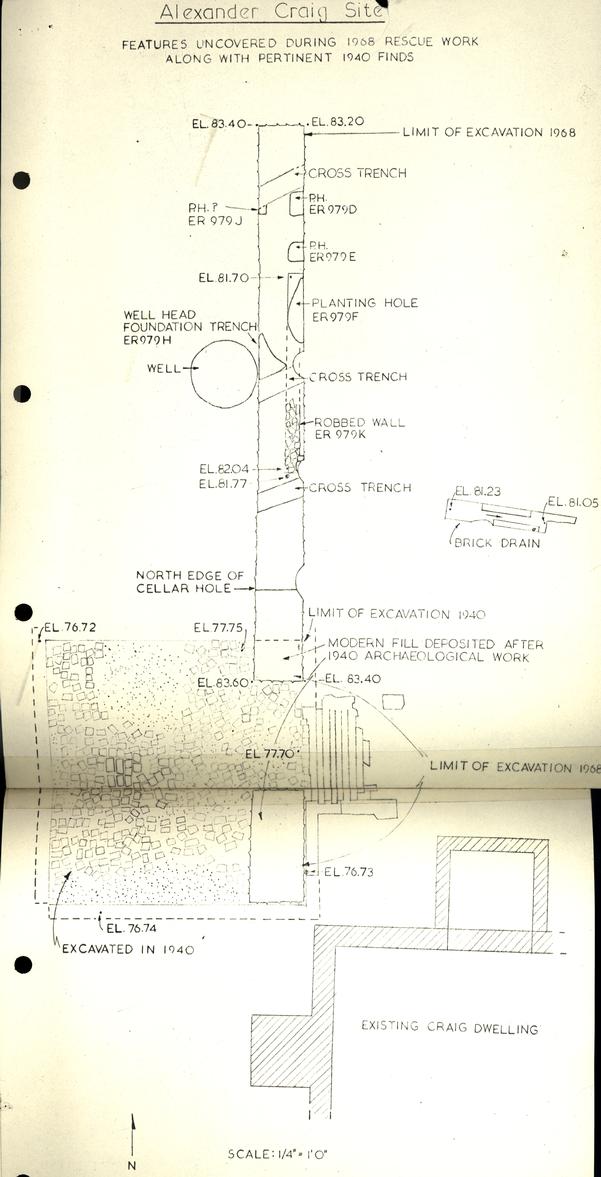 FEATURES UNCOVERED DURING 1968 RESCUE WORK
ALONG WITH PERTINENT 1940 FINDS
FEATURES UNCOVERED DURING 1968 RESCUE WORK
ALONG WITH PERTINENT 1940 FINDS