Burdett's Ordinary Archaeological Report, Block 17 Building 2C Lot 58Originally entitled: "Archaeological Report Burdette Site Block 17, Area C - East; West Side of Colonial Lot 58"
Colonial Williamsburg Foundation Library Research Report Series - 1325
Colonial Williamsburg Foundation Library
Williamsburg, Virginia
1990
Archaeological Report
BURDETTE SITEBLOCK 17, AREA C -EAST
WEST SIDE OF COLONIAL LOT 58
| Page No. | |
| Chronological Table | 2 |
| General Description | 5 |
| Detailed Description | 6 |
| Sources | 11 |
| Insurance Policy No. 849 | |
| Surveyor's Drawing from Seekright vs. Burdette | |
| Section of Archaeological Key Map | |
| Archaeological Drawing: Block 17, Area C. |
June 17, 1931
 Sign of the Red Lion England (from a photostat)
CHRONOLOGICAL TABLE
1717
Francis Sharpe obtained title to lots 57 and 58. Apparently this was a renewal of a title first granted in 1713. The title of 1717 must have been confirmed by the erection of buildings on each lot, for Sharpe was able to bequeath both lots to his sons.
The building on Lot 58 was probably on the west side, for this was the side which seems to have had a building on it when the building was divided later.
1718
Sharpe obtained license to operate an ordinary on either Lot 57 or Lot 58.
1719
Sharpe died. His son, Jacob, inherited Lot 58, which he sold (at some time before 1742) to Thomas Pattison,, innkeeper.
1743
Pattison died.
A lawsuit of this year, Seekright vs. Burdette, is recorded in wording which implies that Burdette was the owner of the west side of Lot 58 - although it is just possible that he was the lessee. The record of this suit together with an appended Surveyor's report, gives valuable evidence as to the location of lot lines. Elevations of the Ordinary, and the dwelling of Lot 57, are also shown.
The lot "and houses", then in the occupation of John Burdette, was bequeathed to Pattison's son, Thomas Jr., after the death of his widow, Anne. Thus if Pattison died after the lawsuit (recorded May 16, 1743), then Burdette was probably the lessee at the time of the suit. If the death had already occurred, then Burdette may already have become the owner.
Pattison's inventory included a sign "Edinburgh Castle", with ironwork.
The following entries apply only to the west side of Lot 58. The east side seems to have been acquired by Nathaniel Walthoe at an unknown date before 1750, and subsequently the two sides have different histories.
1743-6
At some time during this period (if not before) Burdette became the owner of the tavern, since he was able at his death in 1746 to bequeath it to his wife, Mary, and his daughter, Christianna.
1746
Burdette dies. The inventory includes a sign, probably the "Edinburgh Castle" recorded in 1743.
1746-50
Presumably, at some time during this period, Robert Chrichton, -3- merchant, buys the southwest corner (35 ft. sq.) of the property from John Lidderdale.
Aug. 30, 1750
Chrichton sells to Nathaniel Walthoe for £ 350.
1759
Walthoe sells to Benjamin Bayley, merchant, for £ 400.
1762
By this year, according to Research Report of 6.16.32, Walthoe had repossessed the property.
Feb. 1767
Walter Rind seems to have occupied Burdette's Ordinary for use as a print shop.
March, 1768
Advertisement in the Virginia Gazette of Walter Lenox, Perukemaker, mentions "the Red Lion, next door above Mr. Rind's Printing Office..."
1773
William Rind's death.
Note: The identification of William Rind's printing shop with Burdette's Ordinary, coupled with the Lenox advertisement of 1768, is the only known direct evidence that the house on Lot 57 was named the "Red Lion" at this time. Yet it is not altogether certain the Rind's establishment was in fact Burdette's Ordinary. (See Research Report, "Addenda to Burdette and Red Lion", Aug. 1941.) However, this question does not seem to affect the chain of evidence with respect to the building itself, for the years before 1767 and after 1773.
c. 1780
John P. Webb owns Burdette's Ordinary.
c. 1786
The Frenchman's map shows a building which might represent Burdette's: it is next to last on the street line at the east end of the street, and has only one outbuilding of any size. It is two doors east of a series of three small rectangles which together may indicate the Lee site.
1789
Davis Meade owns Burdette's.
c. 1800
In Lot 58, the unknown draftsman shows Meade, while the Bucktrout and Bucktrout-Lively plats show Guardhouse. The latter are probably in the right, since David Meade had moved to Kentucky by 1796 (Research Report, "Red Lion Inn," August, 1941).
1802
Insurance Policy No. 585 indicates that a certain J. W. Dixon owned the property east of the Red Lion. No evidence is available as to whether this Dixon was the same family as Charlotte Dickson, who owned the eastern side of Lot 58 until her death c. 1801.
1808
The account kept for the Union Tavern by Ro. Anderson (who presumably owned the Tavern) indicates that a certain Morrison held the next lot to the east. One Research Report (Red Lion Inn: Addenda: 6.17.32) assumes that the Union Tavern was the former "Red Lion" of -4- Lot 57 and consequently that Morrison owned Burdette's. But no other evidence is known that Morrison owned Burdette's at this time. Indeed there is considerable evidence to the contrary:
- 1.Mr. Charles' Recollection indicate that a house formerly on the Armistead site (the Walthoe site of an earlier date?) was known as the Morrison house.
- 2.The first Research Report on Burdette (6.16.32) states that in 1810 Morrison owned the eastern portion of Lot 58 (previously owned - probably - by Walthoe, later by Armistead), and that it was only after Davis Chalmer's death in 1835 that Morrison bought the western (Burdette) part of the lot.
- 3.In 1817 Chalmer's certainly owned a house on the Burdette site, and the policy of that year in which he insured it (No. 849) shows "Morrison" in the lot to the east.
The above evidence taken as a whole seems to indicate that the Union Tavern was Burdette's rather than the "Red Lion".
At some time before 1817 James Thomson sold the property to Joseph Hague.
1815
Hague owns the property (Policy 1387).
1817
David Chalmers insures the property in Policy No. 849. The dimensions of the house are given as 30 x 27. These are the measurements not of Burdette's tavern but of a later foundation on the same site.
1835
Chalmer's death.
Morrison later bought the property.
Mr. Charles' Recollections indicate that two houses stood on Lot 58 during the mid-19th century:
- 1.On the west, a two-story frame house which existed until after the Civil War. This must have stood on foundation "C", in view of the evidence that the original Burdette's tavern had been superseded by 1817.
- 2.On the east, the Morrison House" (perhaps Walthoe's), which stood until 1883.
GENERAL DESCRIPTION
A tavern stood on the central and western portion of Lot 58 and projected at least 8' into Lot 57. This tavern may have been built as early as 1718, when Francis Sharpe was licensed to operate an ordinary on either Lot 57 or Lot 58. It was certainly standing by 1743, when it was the subject of the Surveyor's report in the Seekright-Burdette lawsuit.
John Burdette's occupancy of the tavern may have begun at any time during the same period, and certainly extended from 1743 until Burdette's death in 1746.
The name "Sign of Edinburgh Castle" seems to have been applied to the tavern before 1743 and as late as 1746. The identity of the name with this site is clearly established as follows:
The Surveyor's plat of 1743 shows Lot 58 as "Burdette's". This is no doubt identical with the lot and houses "in the occupation of John Burdette" which were owned at the time of his death (also in 1743) by Thomas Pattison, Sr., in whose inventory is listed and valued a sign "with irons": "The Sign of Edinburgh Castle".
Burdette's inventory of 1746 lists one sign with the ironwork, probably the same sign.
Between 1746 and 1767 there is a gap in records of the taverns. From the latter year to 1773 it may have been used as William Rind's print shop.
After 1773 ownership changed frequently. The last record of the building is found in Mr. Charles' "Recollections", according too which it stood until after the "War-Between-the-States". In later years it was "a two story frame house, with porch on the western front".
DETAILED DESCRIPTION
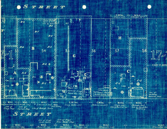
The archaeological drawing shows foundations of several periods on the dwelling site.
Foundation B-C-D (N1205, 9, 10, 11)
Foundation "B", taken together with the west portion of "C", coincides with the dimensions (30 x 27) given for the dwelling of insurance policy No. 849 (1817). The brickwork of "B" is of an earlier character, in the opinion of H. S. Ragland, than that of "C".
The brick drain under the east wall of foundation "C" appears to have belonged to the building of 1815.
It would appear that the building of foundation "C" was prolonged 10' to eastward at some time after 1817.
Chimney "D" may have been built later than foundation "C": the brickwork does not bond.
Foundation B-C-D was clearly later than Foundation "A". Not only was the brickwork in B-C-D of later character than that in "A", but large parts of "A" have been cut away where "B" or "C" crosses over.
Foundation "E" may represent part of an outbuilding which was standing at the same time as the dwelling of 1815. It cannot have been contemporary with the earlier "A" (the east wall of which it would have touched), or with "C" as extended eastward after 1815 (for the walls would have overlapped).
It is probable that any of the above foundations have any historical connection with Burdette's ordinary.
| Size | Color | Mortar | Bond | |
|---|---|---|---|---|
| B | 8-¾ x 4-¼ x 2-½ | Red and Salmon Shell | English | |
| C | 8-½ x 4-½ x 2-½ | Red " | Running | |
| D | 8-¼ x 3-¾ x 2-¾ | Salmon " | " | |
| E | 8 x 3-¾ x 2-7/8 | Red " | English |
Foundation "A" (N-1205, 1209)
This foundation appears to be identical with the Burdette dwelling or tavern of the 1743 Surveyor's report. Evidences of identity are:
- 1.According to Ragland, this is the only brickwork which appeared to be of early colonial period.
- 2.The extant end chimney is an interior one as shown on the Surveyor's drawing.
- 3.The length of the foundation is about 44', whereas the building of the Surveyor's drawing is slightly over 40' long according to the rough scale which seems to have been used.
- 4.If the east line of the Lee house represents the west boundary of Lot 57, and if the lot was 82½' across, then the east line of the lot would cut the Burdette foundation 13' from its west end instead of 8' as indicated by the Surveyor's report. This discrepancy may be of no significance, in view of the known lack of uniformity in the colonial lots as actually laid out. The very fact that archaeological evidence indicates a trespass, even if not of the same degree as that recorded in the lawsuit, seems to be evidence of identity between foundation "A" and the Burdette dwelling of 1743.
Enough of foundation "A" was uncovered to permit accurate determination of the area it probably occupied. A rectangle 21 x 44', no doubt, constituted the main part of the house. The location of the large inside west chimney at the end of the building indicates that the roof was of "A" or gambrel construction. The Surveyor's drawing shows an "A" roof. The drawing also indicates a matching inside chimney at the east end.
A gabled projection is shown at center on the drawing. The peak of its roof extends more than half way up the main roof. In the gable appears a small window which indicates that the projection was sufficient to permit a small room or large closet under the roof. But it was probably not over 6' -8- (the statutory distance from the building line to the street line in colonial times).
Two windows and two dormers appear on each side of the projection in the drawing. The latter is drawn slightly off center of the building, but this is very likely an unintentional inaccuracy.
No evidence of the central projection was discovered when the foundations were uncovered. But the area south of "A" had been so disturbed by the later excavation and building of "B" and "C" that such evidences might easily have disappeared. The west wall of the projection must have joined "A" at a point where the foundation was still extant at the time of the excavation. No evidences of bond are noted on the archaeological drawing, but this again may easily be of no significance. The foundations of such additions often abutted against the main wall without any bond. (A case in point is the northwest corner of the main rectangle, where the foundation of a rear lean-to must once have abutted, but where no definite evidence of bond appears.) On the whole no evidence of any real weight has been found to doubt the evidence of the Surveyor's drawing.
The foundation is 14 to 15 inches thick. The fireplace size is 3'x 5'.
The building was prolonged to the north by a 10' addition, perhaps with a shed roof. The foundation wall is from 9" to 10" thick for most of the building. A small corner fireplace is built into the northeast corner of the addition, and a similar one into the northwest corner.
The depth of foundation "A" indicates that a basement extended under the entire building including the north extension.
There is no evidence of basement floor paving. Not enough brickwork -9- remained to indicate whether fireplaces were constructed for use (i.e., with hearths and flue openings) at this level as well as on the first and second floors; or whether, as frequently occurred, the chimney foundations merely happened to preserve the shape of the fireplaces above.
Laundry "K" (N-1208)
Thirty-five feet north of the west end of "A" was a solid foundation of approximately 3' x 5'. A chimney of this size would be too small for a kitchen, but might well have belonged to a laundry.
Two small remnants of 9" brickwork formed corners east and west of the chimney. These might have represented the walls of the laundry. They lined with the chimney and were equally distant from it. According to their evidence, the laundry was 12' wide with an outside chimney at the north end.
Ten feet to the south was a corner foundation which from its appearance might have been contemporary with the chimney. This evidence, however, cannot be considered as more than contributory, since brickwork can never be precisely dated from its appearance alone. Indications that this was not in fact part of the laundry wall foundation are:
- 1.A building with a chimney of this size would almost certainly be longer than 10', and
- 2.The corner in question fails to line with the northeast corner by about 6".
The mortar in this foundation was made with lime rather than shell, an indication that it was a later period than foundation "A", though still quite possibly colonial.
| Brick | - 8-½ x 3-¾ x 2-¾ |
| Color | - Salmon |
| Mortar | - Lime |
| Bond | - Running |
Well
Twenty feet south of the chimney was a wellhead of indeterminate age. Since the shaft was the only one found on the property it is likely that this was an early well, whether the head was the original one or not. While there is no direct evidence of the south end of the laundry, it seems possible and even likely that this building came as far as the well or close to it. Twenty feet would be a probably length for a laundry 12' wide, and immediate access to the well would be an obvious advantage for such a building.
"Smokehouse - "L"
About 30' northeast of "K" was uncovered a foundation of 9" brickwork, 12' square. There is no evidence of paving. This might have served any of the purposes of small outbuildings: smokehouse, dairy, etc.
| Brick | - 8-¼" x 3-¾" x 2-½" |
| Color | - Red |
| Mortar | - Shell |
| Bond | - Bats |
North of "L" are small patches of brick paving and edges which seem to have belonged to flower beds of an unknown period.
SOURCES
Archaeological Drawing: Block 17, Area "C", 6.17.31. A copy is incorporated herewith.
Archaeological Report of H. S. Ragland, Block 17, Area "C" (Red Lion and Burdette Sites) 3.11.32. Copies are incorporated in Archaeological Report, "Red Lion Site", August, 1941.
Photographs (on file in the Architectural Department)
- N-1205
- N-1208, 9, 10
Research Reports (on file in the Department of Research and Record)
- "Burdette's", Lot No. 58: 6.17.32
- "Addenda to Burdette's and Red Lion": August, 1941
- "Burdette's Ordinary": August 27, 1941
Insurance Policy No. 849: Chalmers (a copy is incorporated herewith)
Surveyor's Report in Suit, Penman vs. Burdette, 1743. An excerpt and the drawing are incorporated herewith.
F.D.
Summer of 1941
Date of Report Determined by work sheets
Suit for Trespass
Policy No. 849 Copy
David Chalmers
June 21st 1817