United States Postal Service Archaeological Report, Block 15 Building 10BOriginally entitled: "The New Post Office Site Block 15, Areas A & B Colonial Lots O & N Report on 1961 Archaeological Excavations Volume I"
Colonial Williamsburg Foundation Library Research Report
Series - 1315
Colonial Williamsburg Foundation Library
Williamsburg, Virginia
1990
THE NEW POST OFFICE SITE
Block 15, Areas A & B
Colonial Lots O & NREPORT ON 1961 ARCHAEOLOGICAL EXCAVATIONS
VOLUME I
| Table of figures. | |
| Acknowledgments. | 1 |
| Introduction and Summary. | 2 |
| Chronology of site history, Colonial Lot O. | 4 |
| Method of excavation. | 5 |
| Building on S.W. corner of Henry and France Street, Feature "A", Area 15A. | 7 |
| The Unlined cellar, Feature "B", Area 15A. | 9 |
| The ditches. | 11 |
| The refuse pits. | 12 |
| The 18th century well, Feature "C", Area 15A. | 13 |
| The Second well, Feature "B", Area 15B. | 19 |
| The "shop" cellar, Feature "A", Area 15B. | 19 |
| The artifacts. | 22 |
| Table of brick sizes. | 24 |
| Dating of excavation register groups. | 25 |
| Notes. | 29 |
| Index. | 33 |
| 1. | Excavated features and detail of Frenchman's Map to same scale |
| 2. | Plan of Features "A" & "B", Area 15A. |
| 3. | Section through basement of Feature "A", Area 15A. |
| 4. | Sections through basement of Feature "B", Area 15A. |
| 5. | Plan of Henry Street ditch line in relation to Feature "A", Area 15A. |
| 6. | Plan of Well, Feature "C", Area 15A and Pit 410 in relation to Feature "B". |
| 7. | Section through well, Feature "C", Area 15A. |
| 8. | Plan of "shop" basement and robbed trenches, Feature "A", Area 15B. |
| 9. | Section through basement filling, Feature "A", Area 15B. |
| 10. | Foundation, Feature "A", Area 15A. |
| 11. | Remains of bulkhead, Feature "A", Area 15A. |
| 12. | Wall and ditch line, Feature "A", Area 15A. |
| 13. | Pier and post holes south of Feature "B", Area 15A. |
| 14. | Bulkhead steps, Feature "B", Area 15A. |
| 15. | Bulkhead steps, Feature "B", Area 15A. |
| 16. | Part of cellar filling, Feature "B", Area 15A. |
| 17. | Early 18th century well, Feature "C", Area 15A. |
| 18. | First bulkhead steps, Feature "A", Area 15B. |
| 19. | Second bulkhead steps, Feature "A", Area 15B. |
| 20. | View across basement of Feature "A", Area 15B. |
| 21. | Building Survey of Colonial Lots N and 0. |
| 22. | Archaeological site plan. |
ACKNOWLEDGMENTS
The excavation of the proposed Post Office site was conducted in the spring of 1961 under the direction of the writer with the assistance of Mr. John Dunton, Archaeological Laboratory Supervisor and the members of his staff. Mr. Dunton directed the excavation of most of Features "A" and "B", Area 15A as well as the early work on Feature C, in the same archaeological area.
Mr. J. M. Knight was responsible for the surveying and for the preparation of final plans and diagrams illustrating this report. Record photography was provided by the staff of the Photography Laboratory, while film footage of work on Feature "B", Area 15A, and the excavation of the well, Feature "C", Area 15A, was shot under the direction of Mr. A. L. Smith.
Professional advice was received from members of the Department of Architecture, particularly from Mr. Paul Buchanan, who, in addition, prepared the Building Survey of Colonial Lots N & O which was used as a guide for the planning of the excavation. Further valuable advice and assistance was received from Mr. J. M. Graham, Vice President and Curator of Collections, Mr. Alden Eaton, Director of Landscape Construction and Maintenance, Mr. William deMatteo, Silversmith, as well as from Doctors George Chohany and John Ratcliff, who provided X-ray facilities at the Williamsburg Community Hospital.
Archaeological Excavations on the Proposed Site for the New United States Post Office, Block 15, Archaeological Areas A & B. Colonial Lot O. April-June, 1961.
Introduction & Summary
Unlike most areas archaeologically excavated in Williamsburg, Colonial Lots O & N were not destined for reconstruction but were being cleared for the building of a new U. S. Post Office whose foundations were likely to destroy most of the surviving colonial remains. Lot O had hitherto been occupied by a parking lot used as a farmers' market, an approach to the large parking area south of the business block, and the old city Fire House. Lot N was occupied only by parking areas.
No research report had been written on Block 15 or any part thereof1 and consequently documentary data was extremely thin, the only substantial evidence coming from the Frenchman's map of 1782 which showed five buildings on Lot O and none on Lot N. The limited excavations of 1961 revealed three colonial buildings on Lot O and none on Lot N. Other finds included one early eighteenth century well, two trash pits and ditches of similar date on the east and south boundaries of Lot O.
Unfortunately the entire area had been disturbed and graded earlier in the present century with results that had caused considerable damage to the colonial levels and to the remains of the eighteenth century buildings. Consequently not one of the foundations was sufficiently intact for a complete ground plan to be obtained. While the foregoing statement suggests that the results of the excavation were less than 3 satisfactory, it must be added that a great deal of information was retrieved that relates to the chronology of the site and the purposes to which it was put at different times. The value of this information will naturally be increased when it can be associated with the subsequent findings of the Research Department.2
Tentative Chronology of Site History. Colonial Lot O.
The following table is derived from documentary sources currently available and from archaeological clues that could, though not necessarily should, be used in evidence.
| 1700-1725 | Ditches dug on property lines and the site occupied, perhaps by person with initials P A. A brick-lined well constructed. | Archaeo. evidence | p. 11, 17 |
| circa 1730 | Well abandoned. | " " | p. 15 |
| circa 1740 | Building, Feature B, probably in existence. Person with initials B K living on site, possibly connected with metal working. | " " | p. 9 ff. |
| 1750-1765 | Well top dismantled by this period. Cellar of Feature B filled with more than 1100 wine bottles and other refuse. | " " | p. 13, 9 |
| 1782 | Five buildings on Lot O. Building, Feature A (15A) in existence also Feature A (15B) and Feature B presumably rebuilt. | Frenchman's Map | |
| 1785 | Wm Cole (butcher) received lot from Samuel Crawley. Cole possibly on site slightly earlier. | Documentary evidence3 Archaeo. evidence | p. 12 |
| circa 1800 | Building Feature A (15B) probably a store or cabinet shop. Person with initials I S possibly in vicinity. | " " | p. 20, 22 |
| 1810 | Wm Bowden received lot from Wm Cole's estate. | Documentary evidence4 | |
| circa 1820 | The "shop" Feature A (15B) destroyed and the cellar filled after 1817. | Archaeo. evidence | p. 22 |
| 1820-1830 | Building, Feature A (15A) destroyed. | "j " | p. 8 |
Method of Excavation
Owing to the presence of packed gravel over the farmers' market area of the site, and in view of the limited time available it was considered permissible to explore those parts of the lot indicated by the Frenchman as being unoccupied, with the aid of a mechanical back hoe. Before doing so an east/west test trench was dug by hand in the hope of bisecting the two colonial foundations indicated by the Frenchman as lying on France Street5 west of South Henry Street. The trench duly provided a section through the filling of the cellar of Feature A (15A),6 but yielded only the slightest traces of a second building to the west of it.
After the first hand-dug trench had been completed, back-hoe trenching was carried out over the rest of the farmer's market as well as those parts of Colonial Lot N that lay to the west of it. The trenches were laid out on a NW/SE axis and spaced some 6'0" apart. In the course of this digging the cellar of Feature B was discovered, as also were the well (Feature C), the east boundary ditch, and two refuse pits, all of which were carefully excavated by hand.
On the evidence of a plan provided by the Department of Architecture7 (Fig. 21) it was supposed that another building would be encountered in the Farmer's Market area north of Features A and B. No traces of this building were found. It was further expected that two other buildings would be discovered, one extending south from the S.E. corner of the fire house and the other protruding from beneath its N.E. corner. It was unfortunately impossible to start work on the latter area (15B) until the fire house had been pulled down and the concrete roadway around it taken up. It was not surprising that the mechanical equipment used by the P.O. building contractors
6to accomplish these ends caused considerable damage to the colonial remains. Only one building was found (Feature A, Area 15B) and this was excavated entirely by hand. The remainder of the eastern section of area 15B was subsequently cross-trenched by hand and two N/S test trenches were dug to the west of the fire house, one of them revealing the top of a comparatively recent well (Feature B, Area 15B) and the other a single post hole that was probably on the E/W colonial lot line north of the fire house.
BUILDING ON S.W. CORNER OF HENRY AND FRANCIS STREET. AREA 15 A, FEATURE A
The remains of a brick-walled cellar was found at the southeast corner of area 15A in approximately the position indicated on the Frenchman's map. The structure was narrower than that shown by the Frenchman, but the archaeological evidence is sufficient to leave little doubt that they are the same.
The cellar possessed 13½" walls laid in English bond with shell mortar (Fig. 10) and measured 13'3" x 18'1", having a much mutilated bulkhead (Fig. 11) at the west end of the north wall. The latter would appear to have steps 4'0" in width. The cellar possessed no west wall, the north and south walls abutting against and overlying a sloping clay bank. A tumble of bricks and plaster lay against the bank indicating that the west wall had not stood too far from it, though no traces of its footings were actually encountered. It is assumed that the bank served as a base for an internal chimney, thus saving on the cost of carrying the brick chimney base through to the basement floor level.8 No traces of a chimney were found.
Elevations taken at the present grade and on the cellar floor were as follows: 87.53 and 82.39. Eighteenth century strata were encountered to the east at 85.91 but this partially stripped deposit cannot be accepted as the colonial grade. The latter had been destroyed all over the site either by the laying of the modern parking lot or by nineteenth century disturbances.
A few fragments of ceramics and glass (ER387D) of the colonial period were found pressed into the cellar's clay floor, (Fig. 3) but 8 none of them was sufficiently large or distinctive for close dating to be possible (see p. 12). The floor was littered with fallen brickbats, plaster, roofing slate and occasional clay flooring tiles identical to those found in the cellar in area 15B.9 Associated artifacts pointed to a destruction date in the decade 1820-1830. However, the upper filling of the cellar comprised black soil with ash and many artifacts dating up to the 1870's. Among these artifacts was a cartridge case of the United Metallic Cartridge Co... that began manufacturing in 1867.10
THE UNLINED CELLAR. AREA 15A. FEATURE B.
The Frenchman's Map of 1782 showed a smaller building west of Feature "A", and while searching for that structure an unlined cellar hole was encountered slightly north of the site indicated on the map. The cellar was somewhat S-shaped in plan with brick bulkhead steps (Fig. 14) at the N.E., or head of the letter S. A dirt floor was encountered at an elevation of 82.21 with the modern parking lot surface being at 87.21. The cellar had a greatest north/south measurement of 15' and an east/west measurement of 10'6" and bulkhead steps 3'8" in width, six in number, each with sockets for wooden nosings.
The cellar hole was archaeologically important in that it contained no fewer than 1109 broken wine bottles, (Figs. 3 and 16) 984 of them in one layer of the fill (E.R.384C) and a goodly collection of English ceramics of the mid-eighteenth century. The bottle fragments included eight seals bearing the initials B I K in association with a merchant's mask. Two other examples from the same matrix have been found, one at the Palace and the other at the Capitol; but the Research Department has so far been unable to identify the owner of the initials. Also recovered was a seal bearing the name Thos. Jones. This is almost certainly the brother of Frederick Jones, both of whom came to the colony in 1702. The former's home site at Tutter's Neck was excavated by the Archaeological Section as an extramural activity in 1960. An analysis of the bottle fragments indicates that the cellar was filled with refuse within a very short space of time in the period c.1750-1765.
10On the basis of the above dating, it must be assumed that the cellar had been filled and the bulkhead sealed at least fifteen years before the Frenchman's map was made. Evidence for a construction date for the building over the cellar was virtually non-existent, the only clues coming from refuse on the cellar floor (E.R.398C) comprising ceramics of the first quarter of the eighteenth century as well as plate glass, and quarrels and canes from leaded windows.12
Clues to the purpose to which the building was put, were not substantial. However, a number of crucible fragments and pieces of metallic slag were found in the cellar fill (see also contents of the well, Feature "C", Area 15A) that could be used in evidence to infer the presence of a metalworker on the site prior to 1765. While it could be argued that the cellar fill had been brought from another site, there is no denying that it came from a common source, and the fact that crucible fragments and slag were also found in the well would support the belief that the material came from the immediate vicinity of Features B and C.
No irrefutable traces of a chimney were found, although a concentration of colonial brickbats (E.R.395) was uncovered in a romboid-shaped patch 5'0" west of the cellar hole. A series of rectangular holes was found around the cellar and it is presumed that some of them housed piers on which the building was supported (Fig. 13). Unfortunately the upper levels of most of these holes had been much disturbed, while others contained post moulds and were cut one into another. If the holes were associated with the cellar, it would follow that the building stood on a north/south axis and measured approximately 36'0" x 22'0". It could equally well be argued that the pier holes belonged to a building constructed after c.1765 and which was 11 standing when the Frenchman's map was made in 1782. The fact that so many of the holes contained colonial artifacts makes it unlikely that they were backfilled as late, say, as the period 1820-1830 when the S.E. building (Feature "A") seems to have been destroyed. Evidence supporting an early date for the pier holes is provided by a fragment of scratch blue saltglaze stoneware found in the S.W. corner pier hole (E.R.391), that joined to another fragment found in the upper filling of the cellar hole (E.R.384A). It could, therefore, be deduced that both holes were open and filled at the same time. Similar evidence came from the complex of holes to the south of the cellar (E.R.392) where a fragment of a rare delftware basket almost certainly came from the same vessel as another sherd found in the main filling (E.R.384C) of the cellar hole.
THE DITCHES. AREA 15A
In the course of backhoe trenching to the east of the site along Henry Street, sections were cut through a ditch that ran north/south upon what is assumed to be the colonial property line (Fig. 5). The ditch was never more than 1'6" in width and had narrowed in places due to early silting to little more than 9". From the section across the ditch (E.R.385) came a small quantity of wine bottle fragments dating from the first quarter of the eighteenth century along with ceramic sherds of the same period. It is reasonable to suppose that the ditch silted up and was allowed to disappear early in the century.
Further traces of a ditch were found running east/west along France Street (Fig. 12) directly west of the south wall of Feature A (Area 15A). It was first thought that this was part of a robbed trench for a continuation 12 of the aforesaid wall and, indeed, it is possible that the wall did continue on the same line. However, the bottom of the cutting yielded a considerable number of ceramic and glass13 artifacts of the early eighteenth century (E.R.399) which seems to preclude the filling from having been deposited after Feature A was destroyed. On the contrary it is much more probable that the boundaries of the lot were originally marked by ditches and that when Feature A was constructed it was set on the same line, thus overlying the earlier ditch. If this is so, it follows that Feature A cannot have been constructed before the second quarter of the eighteenth century. Owing in part to the previous mutilation of the site and in part to limited time available for the 1961 excavations, it was not possible to seek further traces of the south or east ditches.
THE REFUSE PITS. AREA 15A
Although numerous small filled concavities were encountered in the course of the trenching, only two contained a sufficient number of artifacts to merit consideration here.
E.R.410
A small pit (Fig. 5) some 4'7" in diameter and terminating at a depth 1'10" below the present parking lot grade, situated 44'0" north of Feature A. The pit was filled with tightly packed coal ash, oyster shells and animal bones, plus a Westerwald tankard fragment and numerous pieces of clay tobacco pipes, including one almost complete pipe bearing the initials of Robert Tippet. The deposit can be attributed to the first quarter of the eighteenth century.
E.R.411
A large oval-shaped pit situated 18'9" west of Feature B, (Fig. 6) measuring approximately 7'0" x 5'0" and having its bottom 4'0" below the modern grade. The principal layer of the fill (E.R.411A) 12a included creamware that gave it a date in the decade 1770-1780. Among the finds was a well-preserved butcher's cleaver. The latter find might be of significance in view of the fact that the property was obtained by William Cole (butcher) from Samual Crawley in 1785.14 The question then arises as to whether the pit is later than the artifacts suggest or whether Cole occupied the site prior to his acquisition of it in 1785.
THE 18TH CENTURY WELL. E.R.386. AREA 15A. FEATURE C
In the course of cross-trenching with the back-hoe an oval area of black fill 14'0" x 9'0" was encountered to the N.W. of the second foundation (Feature B) on Frances Street. A section was cut partially through this fill, and its great depth immediately indicated the presence of a well whose upper brick courses had been robbed (Fig. 16). After examining the section, the entire black fill, extending to a depth of approximately 7'0", was removed with the backhoe; the deposit yielding wine bottle fragments (the majority dating in the period c.1727-1740), Chinese porcelain, Westerwald stoneware and English white saltglazed stoneware plate and soup bowl fragments. These last were of similar shapes, designs and quality to others found in the filling of the second cellar (Feature B) Area 15A. Cross-mending fragments were found that irrefutably linked the upper filling of the well with the fill of the cellar (E.R.386/384A & C), and provided a terminal date for the former in the period 1750-1765. Both slag and crucible sherds had previously been encountered in the filling of Feature B.
At a depth of 7'0" mechanical digging ceased and work proceeded by hand, the black fill giving way to dirty, sandy clay as the hole contracted to take up the shape of the well shaft (diameter 4'2"). The filling began to yield fragments of wine bottles of the first quarter of the 18th century (fragments of the same bottles extending as deep as 13'6"), a Colono-Indian bowl, delftware, English clay tobacco-pipes, slag, and fragments of iron curb bits.15 One of the fragments was mounted with a large, gilded, and elaborately chased boss. Although the advanced state of the iron's 14 corrosion prevented its true character from being determined, an X-ray photograph taken at the Williamsburg Community Hospital clearly revealed the shape of the iron components.
The lining of the well was reached at a depth of 10'7" (Fig. 17) and was made up from twenty-seven radial bricks measuring 7 5/8" x 5" x 3½" x 2½", giving an internal diameter of 4'2". The bricks were pale salmon, without mortar, and in an excellent state of preservation. It should be noted that the water level was reached at the top brick course, indicating that the lining had been dismantled down to the water.
An examination of the drawn section (Fig. 7) reveals an obvious inconsistency in the chronology of the well's demise. There is no doubt that the extensive top black fill was deposited no earlier than the late 1730's, and the size of the hole might suggest the presence of a brick well head extending six feet or more into the ground. If the robbing of the brick lining ceased at the bottom of the black fill, it could reasonably be deduced that the well had been abandoned and filled in by 1730 (on the evidence of the many artifacts recovered from the fill inside the lining) and that a decade or so later the brickwork was dug out and reused elsewhere. Unfortunately, however, the brick lining did not appear at the bottom of the black fill; instead it lay beneath 3'9" of clay fill containing artifacts of the first quarter of the 18th century only, with joining fragments of the same items extending down into the well to a depth of 18'0". This evidence suggests that the lining had been removed before the filling was inserted, i.e. by c.1730.
If this last thesis were correct, it would be difficult to explain how the 14'0" x 9'0" hole at the top remained open for twenty years without filling with silt washed from the clay banks on all sides. 15 Indeed, a delay of three weeks in the course of the excavation, after the black fill had been extracted, resulted in the deposition of some three feet of washed clay into the bottom of the hole. No such washed deposit was found between the black fill and the contents of the well shaft, thus indicating that the dismantling and upper filling occurred at the same time. The only feasible explanation yet devised is as follows.
In about 1730 the well was abandoned and filled with trash consisting of wood and other organic refuse, clay, and domestic trash, the fill extending above the water level, to within, perhaps, 7'0" of the surface. A decade or so later the brick head was dug out and work began on the dismantling of the brick lining. But as this lay below the level of the c.1730 filling, the fill was dug out sufficiently to enable the bricks to be extracted and the dirt thrown up on to the shelf at the bottom of the head. When the water level was reached the project was abandoned and the loose dirt (from the c.1730 filling) thrown back into the hole whence it came. This done, a quantity of domestic trash, black dirt, and brickbats from the well head were deposited into the large excavation at the top.
It has been suggested alternatively that the entire filling of the well occurred in the period 1750-1765 and that the lower clay filling only differs from the top deposit because it was obtained from a source that comprised nothing but material of the first quarter of the 18th century, and that the top fill contained only material in current use. Such an unlikely coincidence can readily be disproved by the presence of so much wood, leaves, insects - even paper, in the lower filling that could not have survived intact 16 from the 1730's until the 1750's. Consequently these objects had to have been newly discarded when the lower fill was deposited in the well, and if large quantities of perishable trash had become mixed with the early domestic trash, it is inconceivable that no artifacts of the mid-eighteenth century would also have intruded. Furthermore, the scattering of fragments of the same early objects through the lower fill clearly establishes its unity.
The majority of the pottery from the well was encountered at a depth of 13'6", (E.R.386C) and consisted of fragments of four delftware plates, two of them of rare but identical designs in red, blue and green, and one of the others being a smaller version of the bird and floral example found at the Coke Garrett House (E.R.140). It is believed that none of the four examples dates later than c.1730. At the same level as the plates were wine bottles both intact and in fragments.
The clay filling continued down with little change in structure to a depth of 19'0", but becoming steadily darker in color as it progressed, the color change being occasioned by the increasing presence of organic materials, e.g. wood, leaves, and leather. Timber samples from this fill was identified by Mr. Alden Eaton, Director of Landscape Construction and Maintenance, as oak, pine and hickory, and the leaves as oak. But while the oak and hickory pieces came from tree limbs, the pine was represented by board fragments and consequently provides no precedent for its use as a landscape feature in the immediate vicinity of the well. Other wooden items from the fill included a toy boat fashioned from bark (one fragment at 18'6", the other at 20'2"), part of a pulley wheel, the remains of a saddle tree (21'0") and four shoe heels (15'5" - 22'0"). In addition a split oak 17 rail section measuring 4'7" long with a triangular section 4½" x 4½" x 4", was encountered lying vertically against the brick lining at a depth of 15'2". Another rail section of the same length, but with a 3" x 3" x 3" section, was also recovered at the same depth. Owing to the advanced state of decay of the lower extremities of the two sections, it is impossible to determine whether they are two units or were once the two ends of the same rail.
At a depth of 19'0" the filling became darker, wetter, and flecked with marl; organic materials became more prolific, including quantities of leaf and beetle fragments; artifacts also became more plentiful, and it is assumed that the filling from this point onward represented the original silting deposited during the life of the well (E.R.386M-V). Finds included two green glass pharmaceutical bottles (20'0"), a pewter spoon handle bearing the initials P A stamped above a subsequently scratched F, two brass pins and a wine bottle neck of the third quarter of the 17th century (21'0"), a pair of large iron pot-hooks, the handle and part of the bowl of a large iron industrial ladle, a plane iron, and a small glass ink well (22'0"). From the bottom of well, at a depth of 23'0" to 23'10", were found an intact wine bottle of the early 18th century, a broken example of the period c.1690-1710, part of a large saw blade, the remains of a tin coffee (?) pot, a brass sash wheel, (a fragment of an iron sash weight was found at 22'3") and most important of all the finds, a pewter porringer bearing a touch rather similar to that originally registered in 1691, by the London pewterer Joseph Pickard. 18 The touch is located on the underside of the handle and takes the form of the initials I P flanking a pick - Pickard's rebus.16
The brick lining terminated at a depth of 23'9" and comprised a course of thirty-one bricks (as opposed to the twenty-seven at the surviving top), and rested on a 1½" wooden ring made up from seven lap-jointed sections. The concavity beneath the ring was very slight - no more than 6" deep into grey clay in the center, indicating that the well was of no great antiquity when finally abandoned. A small number of radial well brick pieces were found resting at the bottom with one intact brick measuring 7 5/8" x 4 7/8" x 5 5/8" x 2½". Assuming that the well was not dismantled until sometime after it was filled, it must be supposed that these bricks were dropped at the time of construction. It is unlikely that radial bricks could have fallen from the sides during the well's life, and the absence of mortar makes it unlikely that they came from the head.
Conclusions
The well was constructed in the first quarter of the 18th century and abandoned by c.1730, but not dismantled before about 1750. The shaft extended to a depth of 23'10" below the modern grade and was lined with well-fired radial bricks. There was no evidence of damage to the superstructure during the life of the well, and the reason for its abandonment has not been determined.
It was not possible to associate the well with any of the structures identified on the site, although it was proved that the upper filling was contemporary with the filling of the cellar of Feature B. The discovery in both deposits of crucibles and industrial slag might suggest the presence of a metal worker on the site. That surmise was supported by the recovery 19 of slag at 10'0", 17'8", 18'8", and 22'0" the finding of the iron ladle (E.R.386S) at the last depth. On such evidence it might be possible to infer that a metal worker was operating on the site by c.1730.
THE SECOND WELL. AREA 15B. FEATURE B
The top of another bricklined well was found at the rear of the Fire House (Fig. 8), and bridged by the latter's foundations. The purple bricks were laid in successive courses of stretchers and made up a misshapen circle measuring approximately 3'7" in interior diameter. No mortar was seen between the bricks. The feature was not excavated, but it would appear that its top was of comparatively recent date, possibly dating from the second half of the nineteenth century.
THE "SHOP" CELLAR. E. R. 417. AREA 15B. FEATURE A
The filled cellar of a building to the rear of colonial lot O was found in the course of cross trenching immediately in front of and extending beneath the old fire house. Two thirds of the cellar fill was removed (Fig. 9) and from it were recovered large quantities of ceramics, glass and iron artifacts (E.R.417B&C) of the late eighteenth and early nineteenth century. Coins from this deposit included a Virginia halfpenny of 1773 and two United States pennies of 1816 and 1817, the latter providing a terminus post quem for the fill's deposition.
The unlined cellar was cut into clay, terminated in a dirt floor at an elevation of 81.62, and measured approximately 14'9" x 11'3", but being somewhat wider at the west end. At the northwest corner the remains of brick bulkhead steps were found (Fig. 18). But these had been partially dismantled during the life of the building and it was impossible to make 20 an accurate record of their original appearance. Much shell was used in the mortar and many of the bricks were of shapes used in the lining of wells. It could therefore be suggested that they were left over from the construction of a well on the same lot. However, the measurements of the bricks were unlike those from either of the wells found in the 1961 excavations. A careful examination of the bulkhead remains showed that after the steps had been dismantled, shoring timbers had been inserted, some of the brickwork having been cut away to seat the posts.
A second and later bulkhead entrance (Figs. 19 and 20) was found at the southwest corner of the cellar and this feature was in a reasonable state of preservation, though the upper courses had been cut away by the laying of a drain associated with the fire house. The steps were 4'9" in width and each originally had a wooden nosing. The bricks were purplish in color, of more or less uniform size, and laid with sandy mortar containing finely burnt shell.
Pressed into the wet clay floor of the cellar, close to the south steps, were five brass catches for tilt-top tables, (E.R.417E), four of cruciform pattern17 and one circular, but all of them of types dating from the second half of the eighteenth century. It is conjectured that the catches may have been in a box whose bottom became wet and inadvertently decanted the contents on to the cellar floor which, being soft, and damp, permitted some of the catches to sink into it. If this explanation is valid, one may suggest that the items represent part of the stock of either a general store or cabinet-maker. Although a few cabinet locks, a plane iron, file and gouge were among the hardware items in the cellar filling, they were 21 not sufficiently numerous to be significant. In the absence of evidence to the contrary the suggestion that the building was a store seems the more probable. A commercial purpose for the structure is supported by its axis in relation to Henry Street, evidence of which was found in the course of careful clearance east of the cellar.
Although the immediate vicinity all around the cellar was carefully explored, only the slightest traces of the building's foundations were encountered. These were confined to the bottom 1½" of robbed building trenches at the southeast corner (Fig. 8). The trenches were just 1'1" in width which would make it an extremely tight fit if they had housed walls a brick and a half in thickness (13"). It may be wondered therefore whether perhaps the foundations had been only 8" in thickness. Unfortunately the fire house foundations had removed all traces of the rear of the shop and, presumably, those of the chimney. In addition utility lines obliterated the entire north wall line and western end of the southern building trench. Consequently the total measurements of the "shop" can be conjectured only on the evidence of the southeast corner and the lines of the two bulkheads; providing exterior dimensions of approximately 17'0" by not less than 26'0".
No information relating to the building's above ground appearance was forthcoming. Quantities of whitewashed shell plaster bearing the marks of 1" laths were found in the top of the cellar fill as also were a few bricks. One retained specimen (E.R.417A) comprised two bricks roughly chamfered, mortared together and coated with plaster and whitewash, the plaster pierced by a nail. It is possible that the specimen may have 22 come from a chimney shoulder. Scattered through the main cellar fill were numerous fragments of clay flooring tiles, identical to those from Feature A, 15A. Only two intact tiles were found (9 1/8" x 4 0" x 1", pale salmon) but as so many of the others had been broken approximately in half, it is possible that some of them may have been used in that way. Very slight traces of shell mortar were found on one of the fragments, but by and large the majority of them exhibited no identifiable mortar of any kind. It is worthy of note that the clay was fired at high temperature and that it contained sizable quantities of red ochre, the latter a characteristic of earthenwares made from local Tidewater clay.18
The only clue as to the identity of the owner of the "shop" was provided by the discovery of a silver teaspoon (E.R.417C) bearing the roughly engraved initials I S C. In addition a bottle seal bearing the legend "Iosh Hornsby 1774" was found resting on one of the lower steps of the south bulkhead where it had been thrown along with the rest of the main filling after 1817.
In conclusion it should be noted that position of the "shop" compares closely to that of a similarly orientated building shown on the Frenchman's Map.17 Thus it may be inferred that it was in existence during the colonial period and, on archaeological evidence, we may set its demise soon after 1817.
THE ARTIFACTS
The foregoing report on the Post Office site has briefly mentioned only those artifacts that were relevant to the dating and chronology of the area. In due course a report on the artifacts will be prepared under
23separate cover, (Volume II of this report) and will deal in full with the three highly informative groups of material from Features "B" and "C" (Area 15A) and Feature "A" (Area 15B). The value of the material from the "shop" cellar with its associated coins cannot be overestimated. Although the bulk of the group is of post colonial date, it has already thrown much-needed light on the dating of artifacts (and by extension, of building remains) from a period of great change in Williamsburg's history.
TABLE OF BRICK SIZES REMOVED FROM THE POST OFFICE SITE AND PRESERVED
| Location | Measurements | Color | E.R. Number |
|---|---|---|---|
| East wall of Feature A, Area 15A. | 8½" x 4" x 2¾" 8½" x 4" x 2½" | Rich red Purplish red (glazed header) | 414 414 |
| Feature B, Area 15A Bulkhead | 8¾" x 4 1/8" x 2¼" 8½" x 4" x 2½" | Rich red Dull red | 384 384 |
| Feature B, Area 15A cellar fill | 8½" x 4" x 2½" | Purple | 384A |
| Feature C, Area 15A Well | 7¾" x 5" & 3¾" x 2½" 7¾" x 5" & 3¾" x 2½" | Salmon Salmon | 386A 386v |
| Feature A, Area 15B. North bulkhead. | 8½" x 4" x 2½" 8 3/8" x 4 3/8" & 3 3/8" x 2¾" | Salmon Purplish red (well) | 415 415 |
| Feature A, Area 15B. South bulkhead | 8½" x 4" x 2½" 8¼" x 4" x 2½" | Purple Purple | 416 416 |
N.B. Shell mortar in all cases except Feature "C" where no mortar was present.
DATING OF EXCAVATION REGISTER GROUPS FROM THE NEW POST OFFICE SITE, AREAS 15A and 15B
The following dating is derived from the latest artifacts in each assemblage and thus provides a terminus post quem for each context. It must be understood that the dates are based upon a preliminary study of the relevant artifacts and are subject to modification when the associations between all the groups have been studied and when the artifact report has been prepared. It must also be borne in mind that many of the groups contain much that was manufactured and in use long before the final dates suggested below.
| E.R. Group | Dating | E.R. Book Vol. III, p. |
|---|---|---|
| 376 | 1850-1875 | 44 |
| 376A | Unstratified | " |
| 376B | " | " |
| 377 | 1750-1765 | " |
| 378 | Post 1867 | 45 |
| 378A | 1820-1830 | " |
| 378B | " | " |
| 378C | " | 46 |
| 378D | Colonial | " |
| 379 | Unstratified | 47 |
| 379A | Mid 19th century | " |
| 380 | c.1825-1850 | 48 |
| 380A | 1800-1850 | 48 |
| 381 | Mid 19th cen. | 48 |
| E. R. Group | Dating | E.R. Book Vol. III, p. |
| 381A | 1830-1840 | 48 |
| 382 | Modern | 49 |
| 382A | Mid 19th cen. | " |
| 382B | Modern | " |
| 382C | Mid 19th century | 49 |
| 383 | Modern | 50 |
| 383A1 | No dating | " |
| 383A | Unstratified | " |
| 383B | c. 1840 | " |
| 383C | 1820-1830 | " |
| 383D | 1790-1820 | " |
| 383E | " | " |
| 384 | No Dating | 51 |
| * 384A | 1750-1765 | " |
| 384B | " | 52 |
| 384C | " | " |
| 384D | c.1730-1740 | 53 |
| * 385 | 1700-1725 | 54 |
| * 386 | C.1750 | " |
| * 386A-V | 1710-1730 | 54-57 |
| * 387 | Colonial | 59 |
| 388 | Colonial? | " |
| 389 | 1740-1770 | " |
| 390 | 1740-1760 | 60 |
| * 391 | Colonial | " |
| 391A | c.1750 (cross mend to 384A) | " |
| E.R. Group | Dating | E.R. Book Vol. III, p. |
| 391B | c.1750 (cross mend 384A) | 60 |
| 391C | Colonial | 60 |
| * 392 | 1750-1760 (Matching sherd 384C) | 60 |
| 393 | 1750-1760 | 61 |
| 394 | 1730-1760 | 61 |
| * 395 | Late 18th to 19th century | 62 |
| 396 | 18th to 19th century | 62 |
| 397 | Uncertain | 62 |
| 398 | Unstratified | 62 |
| 398A | 1750-1765 (with intrusions) | 63 |
| 398B | 1750-1765 | 63 |
| * 398C | 1700-1725 (comparable sherds in 386G and 399) | 63 |
| * 399 | 1700-1725 (with intrusions. See also 398A.) | 64 |
| 400 | Unstratified | 65 |
| 401 | " | 65 |
| 402 | 1700-1725 (cross mend to 399) | 65 |
| 403 | No dating | 66 |
| 404 | c.1770-1775 | 66 |
| 405 | No dating | 66 |
| 406 | No dating | 66 |
| 407 | 1730-1750 | 66 |
| 408 | Unstratified | 67 |
| 409 | 1840-1860 (on evidence of U.S. artillery button) | 67 |
| * 410 | 1700-1725 | 67 |
| E.R. Group | Dating | E.R. Book Vol. III, p. |
| * 411 | 1770-1780 | 69 |
| * 411A | 1770-1775 | 68 |
| 411B | 1770-1780 | 69 |
| 412 | c.1770 | 69 |
| 413 | Colonial | 69 |
| 414 | No dating | 69 |
| 415 | No dating | 69 |
| 416 | No dating | 69 |
| 417 | Unstratified | 70 |
| 417A | c. 1820 | 71 |
| * 417B | c.1820 | 71 |
| * 417C | c.1820 | 71 |
| 417D | c.1820 | 72 |
| * 417E | 18th to e. 19th century | 72 |
Notes
(b) Wm. Cole appears as a butcher in Alexander Craig's Account Book 1751-1756, p. 63.
30
- Artifacts, discussion of
- 22f
- Artifacts,
- Artifacts,
- Ash
- 8
- coal
- 12
- Back hoe
- 5
- Bank, clay
- 7, Figs. 11, 12
- Beetles
- 17
- Bits
- 13
- Boats, toy
- 16
- Bones, animal
- 12
- Boss, bit
- 13
- Bottle, pharmaceutical
- 17
- Bottles, wine
- 4, 9, 13, 17, Fig. 16
- Boundary lines
- 12
- Bowden, William, acquires lot
- 4
- Bowl, soup, white stoneware
- 13
- Bricks
- See individual features
- 34
- Bulkhead, steps,
- Butcher
- 4, Note 3
- Cabinet shop, or store
- 4, 20f
- Canes
- 10
- Cartridge case
- 8
- Catches, tilt-top tables
- 20
- Ceramics
- 11, 12, 13, 16
- See also individual ware headings
- Chimney,
- Chronology of site
- 4
- Clay, Tidewater
- 22
- Cleaver, butchers'
- 12a
- Coal ash
- 12
- Coffee pot
- 17
- Coins
- 19
- Coke-Garrett House
- Note 8
- Cole, William
- 4, 12a, Note 3
- Colono-Indian pottery
- 13
- Craig, Alexander
- Note 3
- Crawley, Samuel
- 4, 12a
- Creamware
- 12a
- Cross-mends
- 10, 13, 18
- 35
- Delftware,
- Disturbance, prior to excavation
- 2, 5f
- Ditches
- 2, 4, 5, 11f, Fig. 11 plan Fig. 5
- Documentary evidence
- 2, 4
- Excavation, method
- 5
- Excavation Register Groups
-
- E.R. 140
- 16
- " 384
- 24
- " 384A
- 11, 13, 24
- " 384C
- 9, 11, 13
- " 385
- 11
- " 386
- 13
- " 386A
- 24, Note 15
- " 386C
- 16
- " 386M-V
- 17
- " 386S
- 19
- " 386V
- 24
- " 387D
- 7
- " 391
- 11
- " 392
- 11
- " 395
- 10
- " 398C
- 10
- " 399
- 12
- " 410
- 12, Fig. 6
- 36
- E.R. 411
- 12
- " 411A
- 12
- " 414
- 24
- " 415
- 24
- " 416
- 24
- " 417
- 19
- " 417A
- 21
- " 417B
- 19
- " 417C
- 19, 22
- " 417D
- 19
- " 417E
- 20
- Farmers' Market
- 2
- Feature A (15A)
- 4, 5, 22, 24, Note 6, Figs.2, 3, 10, 11, 12, 22
- Feature B (15A)
- 4, 5, 12, 13, 18, 23, 24, Note 6v, Figs. 2, 4, 6, 13, 14, 15, 16, 22
- Feature C (15A)
- 2, 4, 5, 10, 13ff, 20, 23, 24, Note 6, Figs. 6, 7, 17, 22
- artifacts
- 13ff
- associations
- 18
- bricks
- 18
- chronology
- 4, 14ff
- conclusions
- 18f
- construction, dating
- 4, 14f, 18
- destruction, "
- 13, 14ff, 17, 18
- 38
- dimensions
- 13, 14, 18
- elevation
- 18
- head
- 14, 15
- lining
- 14, 15, 18, Fig. 17
- organic fill
- 16f
- plan
- Figs. 1, 6, 22
- primary fill
- 17
- ring, wooden
- 18
- section
- Fig. 7
- Feature A (15B)
- 4, 6, 8, 9, 19ff, 23, 24, Notes 6, 7, Figs.8, 9, 18, 19, 20, 22
- Feature B (15B)
- 6, 19, 20, Note 6
- File
- 20
- Fire House
- 2
- Floor, dirt
- 9
- Flooring, tiles
- 8, 22, Note 9
- Footings
- 7
- France St.
- Note 5
- Frenchman's Map
- 2, 4, 7, 9, 10, 11, 22, Fig. 1
- Glass,
- Gouge
- 20
- Grade, colonial
- 7
- Grading, modern
- 2
- History of site, chronological
- 4
- Hornsby, Josh.
- 22
- Indian pottery
- 13
- Initials,
- Inkwell, glass
- 17
- Insect
- 15
- 39
- Jones,
- Ladle
- 17, 19
- Laths, marks in plaster
- 21
- Leather
- 16
- Leaves
- 15, 16, 17
- Locks, cabinet
- 20
- Market, Farmers'
- 2
- Marl
- 17
- Merchants' mark, on bottle seal
- 9
- Metalworking
- 4, 10, 18f
- Mortar,
- Nosings, step
- 9, Fig. 15, 20
- Ochre, red
- 22
- Organic artifacts
- 15, 16f
- Paper
- 15
- Parking lot
- 2, 7
- Pickard, Joseph, pewterer
- 17
- Piers
- 10f, Fig. 13
- dating evidence for
- 11
- Pins
- 17
- Pipes, Robert Tippet
- 12
- Pits, refuse
- 2, 5, 12f
- Plane, iron
- 17, 20
- Plaster
- 8
- 40
- Plates,
- Porcelain, Chinese
- 13
- Porringer, from well
- 17
- Post hole
- 6, 10, Fig. 13
- Post, shoring
- 20
- Post Office
- 2
- Pot-hooks
- 17
- Pot, tin
- 17
- Property line, colonial
- 11, 12, Fig. 12
- Pulley, sash, brass
- 17
- Pulley, wood
- 16
- Quarrels
- 10
- Rail, oak
- 16f
- Research report
- 2, Notes 1, 2
- Ring, wooden, in well
- 18
- Roofing, slate
- 8
- Saddle, fragments
- 16
- Saw blade
- 17
- Scratch blue, dating for piers
- 11
- Seal, bottle,
- Shells, oyster
- 12
- Shoes, heels
- 16
- Shop, Feature A (15B)
- 4, 19
- Shoring, of steps
- 20, Fig. 18
- 41
- Silting, primary, in well
- 17
- Slag
- 13, 10, 18f
- Slate, roofing
- 8
- Spoon,
- Steps, bulkhead
- See Bulkheads, Steps
- Steps, wood nosings
- 9, 20, Fig. 15
- Stoneware,
- Store, possible
- 4, 20f
- Tankard, Westerwald
- 12
- Tax records, Williamsburg
- Notes 3, 4
- Tiles, flooring
- 8, 22, Note 9
- Tin pot, (coffee)
- 17
- Tippet, Robert
- 12
- Tools, in cellar fill
- 20
- Trench, robbed
- 11f, 21, Fig. 12
- Trenching
- 5, 6
- Tutter's Neck
- 9
- Water level, in well
- 14
- Weight, sash
- 17
- Well
- See Feature C (15A) and Feature B (15B)
- Westerwald, tankard
- 12
- Whitewash
- 21
- Wood
- 15, 16, 18
- Wooden ring, well
- 18
- Windows, leaded
- 10
INDEX
 Figure 1
Figure 2
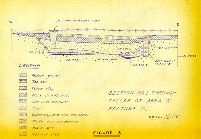 Figure 3
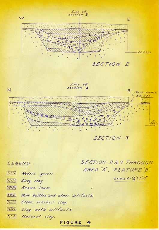 Figure 4
Figure 5
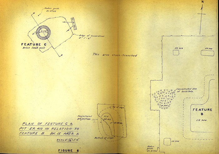 Figure 6
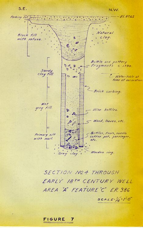 Figure7
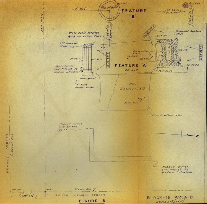 Figure 8
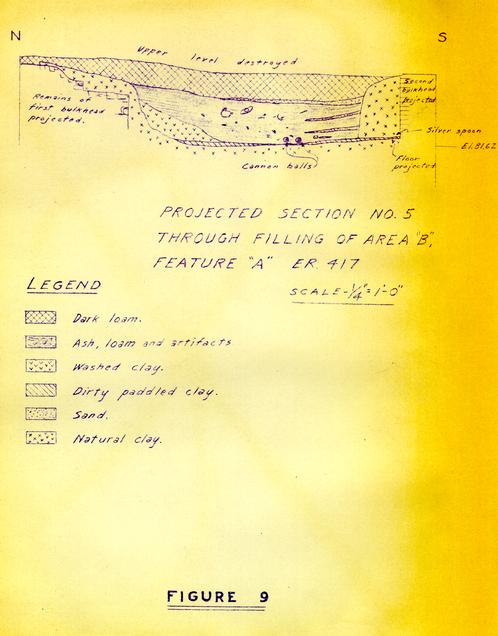 Figure 9
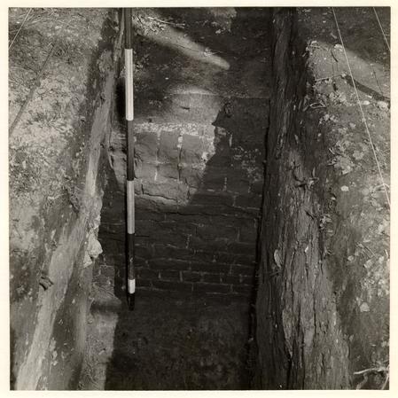 Figure 10
Interior face of the east foundation of Area "A", Feature "A", with part of section No. 1 in left foreground; the ranging pole resting on the cellar floor. Photo from the west. 61-ST-230-15.
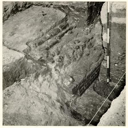 Figure 11
Remains of bulkhead and north wall of Area "A", Feature "A", with sloping bank at west end of cellar in foreground. Photo from the S.W. 61-RW-285-5.
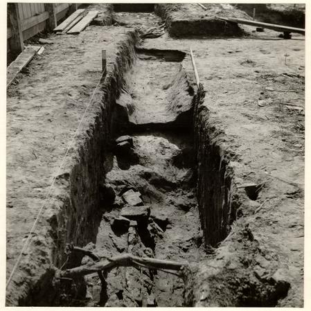 Figure 12
Trench on line of south wall. of Area "A", Feature "A" showing clay bank at west end of basement in middle distance with section through earlier property boundary ditch directly beyond it. Photo from the east. 61-JD-624
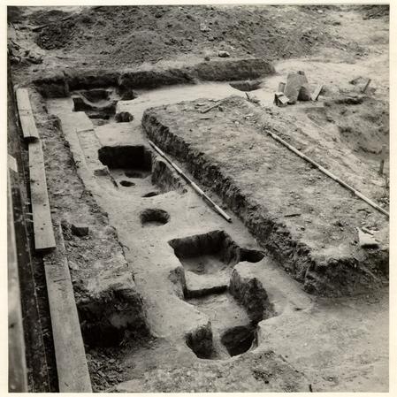 Figure 13
Groups of post and pier holes to the south and west of Area "A", Feature "B". Photo from the southeast. 61-JD-623
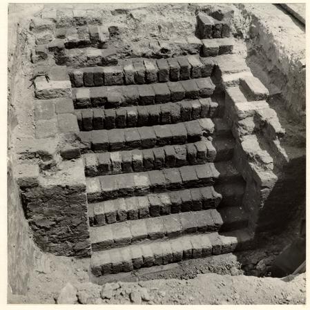 Figure 14
Bulkhead steps Area "A'", Feature "B" with north clay wall of cellar in left foreground. Photo from the west. 61-JD-626
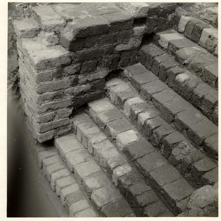 Figure 15
Bulkhead steps Area "A", Feature "B" showing sockets for wooden nosings. Photo from the southwest. 61-JD-625
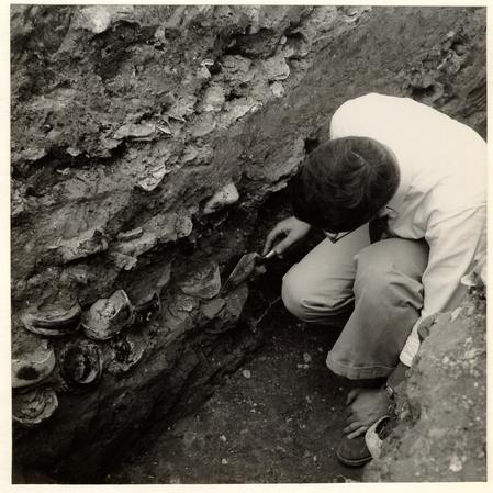 Figure 16
Part of Section No. 2 through cellar filling of Area "A", Feature "B" showing some of the more than one thousand wine bottles that the deposit contained. Photo from the S.W. 61-JC-305-4
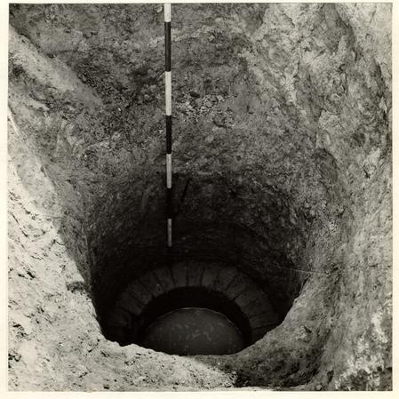 Figure 17
The early 18th century well, Area "A", Feature "C" Prior to the excavation of the lined shaft. Photo from the northeast. 61-JC-302-1.
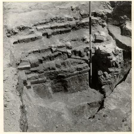 Figure 18
First bulkhead steps of Area "B", Feature "A", ranging pole standing in socket for vertical timber support, with a similar hole to the left of it, both inserted after bulkhead was dismantled. Photo from the south. 61-JC-324-5
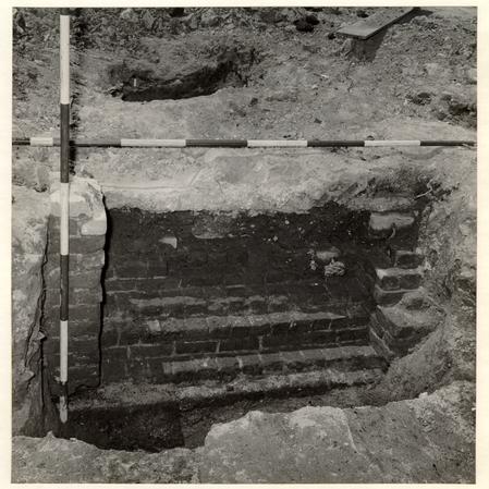 Figure 19
Second bulkhead steps of Area "B", Feature "A". Photo from the north. 61-JC-324-3.
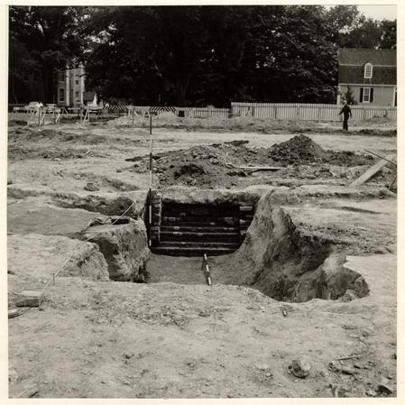 Figure 20
View across Area "B", Feature "A" towards France Street with the second bulkhead steps in the middle distance. Photo from the north. 61-ST-327-11.
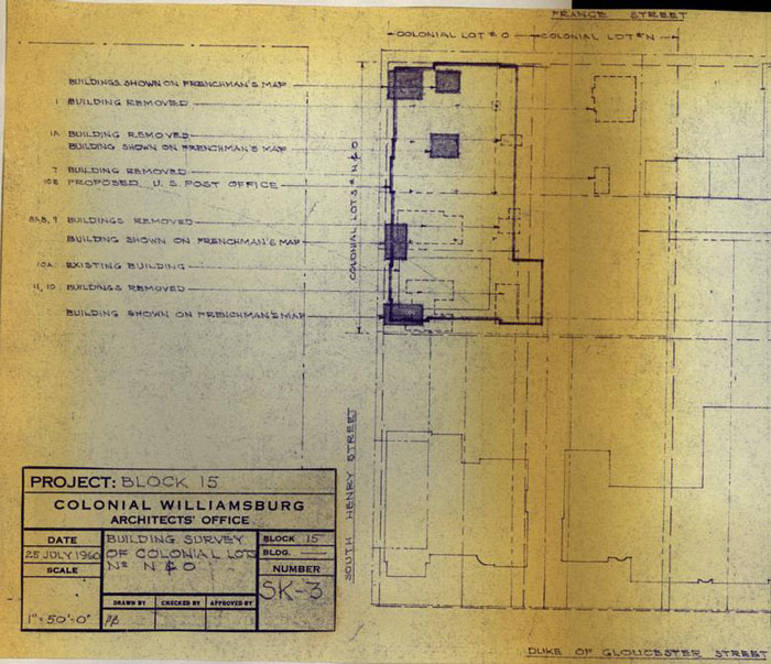 Figure 21
Figure 22