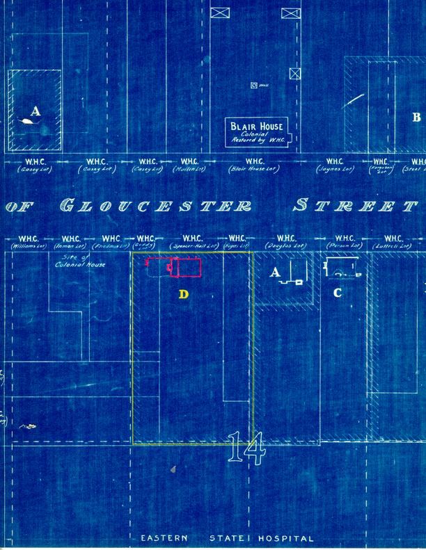
Lot No. 42 Archaeological Report, Block 14 Lot 42Originally entitled: "Archaeological Report Block 14, Area D (Colonial Lot No. 42 - Moir Lot)"
Colonial Williamsburg Foundation Library Research Report Series - 1313
Colonial Williamsburg Foundation Library
Williamsburg, Virginia
1990
ARCHAEOLOGICAL REPORT
BLOCK 14, AREA D (Colonial Lot No. 42 - Moir Lot)
This lot is located just west of the Durfey or Taliaferro lot according to the Bucktrout and Unknown Draftsman's maps. Archaeological investigation of this area was begun in December, 1940, after the lot to the east had been completely excavated. The latter lot as well as the others in this block had been plowed over after all the modern buildings had been razed, destroying any archaeological evidence to the depth of the plow line.
Evidently most of the records concerning this lot have been destroyed and the only documentary data available at present appears to be that shown on the Bucktrout and Unknown Draftsman's maps. The lot in question is indicated as being one of the two Moir lots in this block. The Frenchman's Map of 1782-86 does not show anything on this location.
EIGHTEENTH-CENTURY BUILDING FOUNDATION
Archaeological investigation brought to light the remains of two building foundations at the north end of this lot next to Duke of Gloucester Street. The earlier one was of a 30'-2½" x 20'-2¾" eighteenth-century building which was overlapped partly by the remains of a nineteenth-century foundation. This early foundation had a full basement which showed evidence of having been dug after the building had been constructed. No trace of the south or west foundation wall could be located, although the north and east walls as well as three of the original corners still existed. This made it possible to determine the overall dimensions. The footing elevations of the remaining walls were from 2'-6" x 3'-0" above the basement floor level.
-2-Basement steps with rebates and holes for built-in wood nosings were located on the west end near the northwest corner. The footing elevation of the steps also was 3'-0" below the wall footing and approximately the same as the floor level. No evidences were found of the steps and foundation walls having been bonded together, although the brick sizes and color of the mortar was the same. This also seems to be a pretty fair indication that the basement and steps came later than the rest of the eighteenth-century brickwork.
The wall thickness ranged from 13½" to 14½" with some glazed end brick.
The strata of earth composed of fill and top soil, which became visible along the north wall indicated that this building was constructed in a slight depression of the ground. Originally the area was the head of a ravine which ran northeast across the Duke of Gloucester Street. According to records, Duke of Gloucester Street was graded and leveled between 1720 and 1724; therefore, it may be safe to say that the building was constructed prior to that date, while the basement was placed under it after the ravine which crossed the street had been filled.
No chimney foundation or any evidence as to its location could be determined. Very probably it was on the west end or possibly on the rear or south sides similar to that of the Powell-Craig House which was located on York Street, or the old portion of the Casey House which formerly stood just across the street from this site.
The basement floor was not paved and there was no indication of the use of paving.
-3-All traces of the front and rear entrance steps to the first floor had been destroyed, leaving no indication as to the exact entrance location.
Most of the fill and debris which came from the basement was composed of black earth mixed with broken bricks and shell mortar fragments. Several boxes of broken ale bottles of the eighteenth-century variety were found scattered around near the bottom, also a few broken pieces of eighteenth-century china. It appeared that this site was used as a dump for rubbish for a number of years after the original structure had been demolished.
| Brick size - | 9" x 4 ½" x 2-3/8" |
| Color - | Light red and buff |
| Bond - | English |
| Mortar - | Oyster Shell |
| Condition - | Fair |
NINETEENTH-CENTURY BUILDING FOUNDATION
Just to the east of the eighteenth-century foundation were the remains of a nineteenth-century building foundation. This was constructed overlapping 8' of the east and of the earlier foundation. The west end of the late building had been erected on approximately 3' of fill and debris which was in the eastern portion of the basement of the early structure. With the exception of several top courses of brick, the complete remains of this foundation still existed. It was originally a building 30'½" X 18'-1¼" with no basement.
There was an outside chimney on the west end which was built on considerable fill as were the west walls of the building. This fill had been well packed before the construction of the chimney; otherwise there would have been a gradual settling of the brickwork. No indication of chimney settlement was noted, and it may be that a number of years elapsed between the time the -4- eighteenth-century basement was backfilled and the nineteenth-century building was constructed. This period of time may have included the year 1782-86 when the Frenchman made his map as he did not show any building on this lot.
Remains of an entrance were found on the north side of the building, 4'-2½" from the northeast corner. This appears to have been a porch or entrance which was 8'-7" in width.
The foundation was constructed of many bats with an average wall thickness of 13½". It may be noted that the bond of the brickwork had the appearance of both English and common bond due mostly to the use of broken brick.
| Brick size - | 8½" x 4" x 2¾" |
| Color - | Brownish red |
| Bond - | English and common |
| Mortar - | Oyster shell |
| Condition - | Good |
See Photographs N6561, N6562, N6563, and N6564.
James M. Knight
Colonial Williamsburg Architectural Department
September 16, 1942
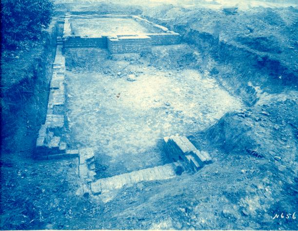 Photograph N6561
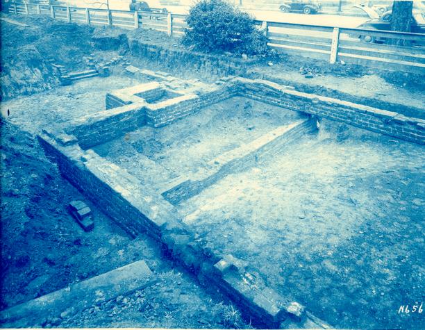 Photograph N6562
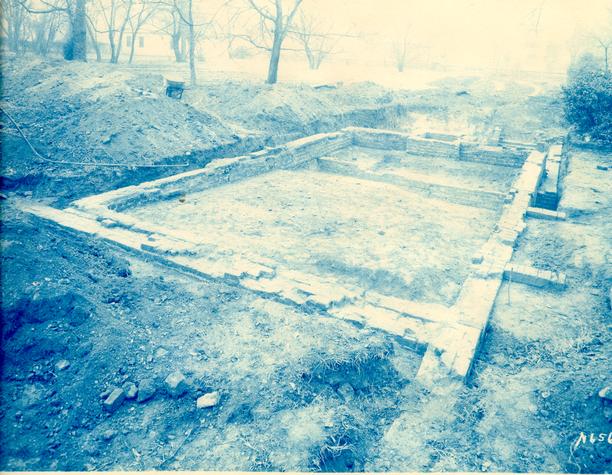 Photograph N6563
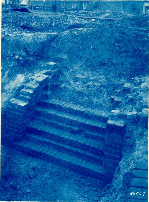 Photograph N6564