John Lockley House Site Archaeological Report, Block 14Originally entitled: "Salvage Excavations at the John Lockley House Site Block 14, Area E"
Colonial Williamsburg Foundation Library Research Report Series - 1312
Colonial Williamsburg Foundation Library
Willilamsburg, Virginia
1990
John Lockley House Archaeological Report Block 14 Area E
SALVAGE EXCAVATION AT THE JOHN LOCKLEY HOUSE SITE
1976
Block 14 Area E
TABLE OF CONTENTS
| Introduction | 1 |
| Historical Summary | 1 |
| Archaeology | 4 |
| Architectural Phasing | 9 |
| Artifacts | 13 |
| Conclusions | 16 |
| Appendix I: Pipe Stem Dating | 18 |
| Appendix II: Brick and Mortar Examples | 19 |
| Appendix III: Excavation Register Series | 20 |
| Figure 1: Frenchman's Map and Archaeological Site Plan Drawn to Some Scale | Following p. 1 |
| Figure 2: Archaeological Plan and Sections | Back Pocket |
| Plate I: Excavated cellar area from West | Following p. 5 |
| Plate II: Detail of brick pier | Following p. 7 |
| Plate III: Detail of cellar's South wall | Following p. 8 |
SALVAGE EXCAVATION AT THE
JOHN LOCKLEY HOUSE SITE
1976
Introduction
The John Lockley site, Block 14, Archaeological Area E, was first investigated in 1950 by Mr. James Knight. At that time the foundations of a structure built in several phases were exposed and recorded, along with the remains of three outbuildings. No further excavations were carried out until late January 1976 when a portion of a previously recorded wall line and part of the fill of a cellar were again exposed in preparation for the construction of a new visitors' facility to serve the Merchants Square area.
Historical Summary
The majority of the James City County records were destroyed during the Civil War. From the few remaining documents, Miss Mary Stephenson prepared a history of Lots 41 & 42.1 From this research paper have been gleaned the majority of the following historical references.
Colonial Lot 41 was granted to John Blair, merchant, by the trustees of Williamsburg, January 6, 1719, and to Thomas John January 12th of the same year.2 No explanation of this duplication of ownership has been found. Information relating
 From Frenchman's Map 1782?
2
to either of the aforementioned "owners" building on Lot 41 is not available.
From Frenchman's Map 1782?
2
to either of the aforementioned "owners" building on Lot 41 is not available.
John Lockley, a painter, plasterer, boarding house owner, barkeeper, merchant, and general entrepreneur, is the first documented occupant of the site. Lockley was resident in the city as early as 1773 when he was employed by Mrs. Vobe as a barkeeper.3 The following year he was taking boarders at his own house, but the location of this dwelling is not known.4 An advertisement in the Virginia Gazette of November 4, 1775 gives Nicholson Street as the position of Lockley's establishment.5 The first known record of his being on Lot 41 occurred in July 1778 when Lockley offered for sale cod fish, sugar and plums at this place "near the college."6 Late notices in the Gazette in 17797 and 17808 refer to his keeping boarders. Taxes for Lots 41 & 42 were charged to Lockley in 1782.9
Lockley sold the two aforementioned lots to Wyatt Coleman in 1785.10 No profession is listed for Coleman, but he was charged tax on a billiard table in 1794. This table was not used 3 in an ordinary, as no license for such was issued to Coleman that year.11
The property became part of the Coleman estate in 179812 from which James Moir bought it by 1801.13 Williamsburg tax lists show Moir holding title until 1810.14
The following year, one Thomas Turner is listed as owner, having bought Lots 41 & 42 from Moir.15 Turner, who held a retail merchant's license from 1809 until 1821,16 had died by April 1823, leaving a widow, and naming Richard Donnelly as administrator of his estate.17 Mrs. Turner still occupied the dwelling in 1836, with William Welsh, a retail merchant, renting the "store" from 1834 to 1838.18
The Reverend Scervant Jones acquired the property after the death of Mrs. Turner in 1838,19 and occupied the site until his demise in 1854.20 During the period of his occupancy, 4 students from the college were taken as boarders in "offices" located along Henry Street.21
Taxes were charged to the Jones estate through 1858,22 but the next year the title to the land had been transferred to Charles C. P. Waller.23 Waller, a storekeeper and clerk for the Asylum, abandoned the property between 1861 and 1865.24 He again paid taxes on the lot in 1865 with the notation that his dwelling (Fig. 1, buildings B & B1) had been completely destroyed.25
Archaeology
As has been previously noted, archaeological investigations were pursued in 1950 by James Knight of Colonial Williamsburg. At that time the majority of the structural information used in this paper was recorded. The method of excavation was to outline foundations by trenching along such features and digging "cross trenches" to attempt to locate additional building remains. Following the outlining of the discovered features and the recording of the same, no fill was removed from the interiors of the cellars except that which lay next to the walls; thus no stratigraphic studies had been made, and all stratigraphy overlying the walls was lost.
5On January 20, 1976 archaeologists watched trenching preceding the construction of the new visitor facility. As expected, the trenches for seating of foundations of the northern portion of the new structure cut the fill of the western cellar of the John Lockley House. The fill from approximately one-half of the cellar was removed prior to the construction of the new bus shelter.
The cellar fill comprised, in descending order, brick rubble, a layer of plaster, mixed gray loam, and a dark ashy stratum, all sequentially overlying the natural clay floor of the basement (see Fig. 2, Section B-C). Topsoil, clay, and all but three inches of the brick rubble were removed mechanically. Following the removal of the remaining rubble by hand, the plaster layer (E.R. 2124A and 2124B) was excavated, yielding quantities of white and dark gray over white painted plaster, along with pipe stems offering a mean date of 1758 (see Appendix I), and artifacts ranging in date from the mid-eighteenth century to post 1830.
The mixed gray stratum (E.R. 2124C) was removed next. This layer contained "white ware"; a hard semi-porcelain, and earlier types of ceramics, fragments of plaster, and pipestems which when analyzed gave a mean date of 1773 (Appendix I). The other artifacts date the fill as post 1825, as opposed to the early pipestem reading.
Several features were located beneath the mixed gray, some of which might have cut the stratum, but were not identifiable because of the homogeneous nature of the fill. An area of brickbats (E.R. 2124E) was found resting on natural and surrounded
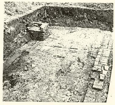 Plate I. View from the west showing the re-excavated south wall (E.R. 2124Z) and brick pier (E.R. 2124P). CW Neg. #76-1693
6
by a thin layer of sand (E.R. 2124W), all below the gray mixed fill. No form to the brick feature was perceived except in the two northern-most bricks, which were laid square to each other. Possibly this was a walkway across a damp cellar floor.
Plate I. View from the west showing the re-excavated south wall (E.R. 2124Z) and brick pier (E.R. 2124P). CW Neg. #76-1693
6
by a thin layer of sand (E.R. 2124W), all below the gray mixed fill. No form to the brick feature was perceived except in the two northern-most bricks, which were laid square to each other. Possibly this was a walkway across a damp cellar floor.
Also under the gray fill was a post hole (E.R. 2124K). The hole contained fragments of an early eighteenth-century pharmaceutical bottle and a brick. As the latter had been placed in the bottom of the hole, a support seating is implied, but because of the limited scope of the excavation, the structural relationships of this and other holes investigated within the cellar is not clear.
The layer of black ashy fill was next to be taken up. This stratum (E.R. 2124F) covered the northwestern quarter of the excavated area and varied in thickness from just a stain along its southern and eastern extremities to two and a half inches at the cut for the new building's north wall. A test in the northern balk revealed that this stratum continued to gain in depth toward the northwest. It should be noted that the western bulkhead located in 1950 is in the region of the deepening fill and as the cellar entrance would have received more wear than the surrounding area, as fill could have been deposited to absorb moisture and level the floor. Artifacts recovered from the layer date post 1785, but with a Binford pipestem dating of 1768.
Among the other features noted beneath the dark ash (E.R. 2124F) was a shallow deposit of mixed ashy fill (E.R. 2124N) which contained creamware, and sealed two holes (E.R. 2124S and E.R. 2124T). Both holes contained a mixed dark ashy fill and 7 were cut by the new construction trench. The first hole (E.R. 2124S) is dated in the period 1740-1750 and the second as post 1770.
Four other post holes were revealed following the removal of the black layer. E.R. 2124H and E.R. 2124L were of colonial date with E.R. 2124V as post 1750 and E.R. 2124J dated as after 1800. As has been previously noted, no relationships between the post holes and foundations could be found.
Under the gray and black strata was a very thin greenish clay (E.R. 2124M) that appeared to have been tracked across the floor. Stratigraphic studies south of the southern wall revealed a layer of similar color and texture deposited after the digging of a large hole in which the cellar sits. This stratum is cut by the seating trench for the wall. It is probable that the greenish clay found above the natural floor of the basement is the remains of the early clay fill. Beneath the greenish clay along the western extent of the excavated area, a shallow deposit of light colored sand (E.R. 2124G) overlay the natural floor.
One architectural feature was located in the confines of the 1976 excavations (Plate I). A brick pier measuring 2' 7" x 2' 9" (E.R. 2124P) was exposed following the removal of brick rubble. The pier was seated into the mixed gray fill. As the brickwork lay along the line of the proposed new foundation, it was decided to dismantle the feature for study. The bonding of the pier was irregular, with the outer brick courses laid in random fashion of rectangular bricks (see Appendix II), and the center made up of brickbats (Plate II and inset 1, Fig. 2). A soft
Plate II. Close-up view from the southeast of pier (E.R. 2124P) after the removal of gray mixed fill (E.R. 2124C) showing stratum (E.R. 2124R) beneath the brickwork. CW Neg. #76-1692
8
yellow shell mortar was the bonding agent. After the brickwork was taken up, the fill beneath (E.R. 2124R) was investigated, and creamware was recovered from it.
The cellar's south wall (E.R. 2124Z), which had been excavated in 1950, was re-examined (Plate III). Although only three courses survived in the area of excavation, enough remained to show that the foundation was constructed in an unusual manner, using both rectangular and "compass" or well bricks (see inset 2, Fig. 2, Appendix II). Unfortunately, the cellar's interior stratigraphy could not be studied in relation to the wall, as previous archaeological trenching had removed the fill abutting the brickwork. A shallow builders trench, south of the wall, was seen in the eastern section (see section C-D, Fig.2). The use of a seating trench for a cellar wall is unusual but not unheard of. Most foundations were laid on the natural basement floor even when the hole dug for the cellar is larger than the dimensions of the finished structure.
South of the wall, a large area of fill was noted in the stratigraphic sections revealed by the construction trenches. The fill extended nine feet to the south and across the full east-west extent of the excavated area. It rested on a flat "bottom" cut into the natural clay at the same elevation as the cellar floor. Six strata comprised this fill. Beneath the topsoil was a three inch layer of fine brick rubble (E.R. 2124X) from the demolition of building "A" (see Fig.2), laying atop brown-gray sandy loam (E.R. 2124Y). Beneath the loam, sticky yellow redeposited clay (E.R. 2125A) was found above a sandy yellow clay (E.R. 2125B) overlying a thin deposit of grayish shell
Plate III. View from east looking west of portion of extant southern wall (E.R. 2124Z). Note use of well brick in conjunction with rectangular brick seen looking west. CW Neg. #76-1691.
9
mortar (E.R. 2125C). The bottom stratum (E.R. 2125B) was a silty gray clay. This clay, mentioned in the discussion of the internal stratigraphy, had been formed between the digging of the large hole and the construction of the southern cellar wall, as attested by the mortar overlying it. This excavated area beyond the cellar's confines may have resulted from brick-clay digging or a miscalculation in the size of the intended cellar hole. Whichever was the case, the nature of the stratigraphy indicates that the area stood open for some time before construction began, and that fill was needed to bring the ground surface back to grade following the raising of the south wall.
Architectural Phasing
Insurance plats and the Frenchman's Map (ca.1782) are the primary sources of information concerning the many changes in the configuration of the John Lockley House during the ninety plus years that structures stood on the foundations uncovered by archaeological investigations. The correlation of the documentary evidence with the archaeological findings enable the formulating of a chronological phasing for the various construction and destruction activities that took place on the site (Fig. 1).
Mr. Knight exposed structural remains suggesting an "L" shaped building measuring 62' 0" x 20' 0" with an extension on the south of the eastern element when the house had grown to its largest configuration. The excavations in 1976 added only the brick pier (E.R. 2124P) to the record of architectural features.
The Frenchman's Map shows a long, rectangular building on 10 Lot 41, measuring approximately 62' 0" x 20' 0" and facing north to Duke of Gloucester Street (Fig. 1). This would be the house occupied by John Lockely. Comparing the Frenchman's drawing with the Knight plan, it is certain that by 1782 three building phases had been completed (see Plan, Fig. 2). The earliest structure on the lot (Phase I) measured 38' 0" x 20' 0" with a cellar. Next, two closets were added at each end south of the chimneys (Phase II). The western chimney may have been the second addition, but further excavations would be needed to substantiate this premise. Following the adding of the closets, a 27' 0" x 20' 0" structure (Phase III) was attached to the eastern end of the first building. Entrance to the new wing's basement from the Phase I cellar was effected by the removal of a portion of the basement's eastern wall. The three construction periods brought the house to the shape noted in 1782.
After the Frenchman's Map, the only drawing or written descriptions of houses on Lot 41 come from insurance plats, the first of which was issued in 1802 for James Moir. The accompanying sketch is identified as "a dwelling house 60 x 20 feet 2 story high built of wood and covered with wood."26 These dimensions parallel those of the combined first, second, and third phases with an error of only two feet in length.
Moir again insured his holdings in 1806, but by this time further additions had been made to the house, which then was described as "a wooden dwelling house 1 story Dutch roof 24x36 11 with an extension. . .wooden also one story high 38x18 to the west."27 An addition (Phase IV) had been built south of the Phase III house. Until 1806, the bulkhead at the western end of the earliest house was the only recorded exterior entrance; but when the new extension (Phase IV) was built, its cellar was entered through a bulkhead to the south. The southern wall of the Phase III foundation was breached in two places to allow movement between all the cellars. Also, a well shaft was overlayed by the Phase IV construction. It is not known, however, if the well had been abandoned previously or rendered useless by the wing (see map #1).
(Henceforth, phases I and II will be referred to as Building "A" and phases III and IV as Building "B" and "B1" respectively.)
The property was insured by merchant Thomas Turner of his executor in 1815, 1823, and again in 1830.28 Although no changes were noted between these dates, it is of interest that in 1830 a "store" was insured.
The Reverend Jones became owner of the western part of the lot, and during his ownership, the house was insured in 1839, 1840, and 1853.29 The policy of 1839 and subsequent notations give only a plan for Building "B". John S. Charles, in his "Recollections" spoke of ". . . a very large and attractive 12 frame Dutch-roofed house, with platform along the side and end with substantial railing, with its front on Duke of Gloucester Street. The western end of this house was distant about forty feet from Henry Street. To the south and west of this house was a beautiful grass lawn."30
From the Charles account we know that by 1860, Building "A" was no longer standing. The probable destruction date for the earliest house was in the period 1839-40 when Jones prepared the lot for the boarding of students in "offices" along Henry Street. The artifactual evidence from the cellar supports that conclusion and suggests a deposition date earlier than the date for the fill-- close to 1835.
Following the removal of Building "A", new foundations and walls had to be constructed for the western end of Building "B". This structural addition (Phase V) crossed atop the chimney base at the eastern end of Building "A" (see Plan, Fig. 2).
A final policy was issued in 1860 to Charles Waller, who owned the house, Building "B" and "B1", until it was burned during the Civil War. Thereafter, the lot was divided, but by then all the colonial building had gone.
The pier located in 1976 cannot be attributed to a particular building phase. Seated as it was beneath Building "A", halfway between the north and south wall and approximately one-third of the way east-west, there are few possible explanations for the use of this post 1775 feature. The most plausible may 13 be that it supported a sagging beam.
Artifacts
Artifacts recovered during the John Lockley salvage operations present a wide range both in time and style. The known life span of the western portion of the structure, Building "A" (ca. 1778-1839), was a period of many changes in household goods used in America, especially the ceramics.
Rhenish and English brown saltglazed stoneware, green-glazed and black-glazed coarse wares of imported utilitarian types were found throughout the strata studied. Locally made Colono-Indian shell-tempered wares were also found.
The tableware ceramics recovered included delftware, white salt-glazed stoneware, creamware, pearlware, white ironstone and Chinese export porcelain.
Delftware found came from post 1825 contexts in all but two cases. In post hole E.R. 2124S and E.R. 2124V defltware was the only ceramic excavated.
Few pieces of white saltglaze were recovered. One white salt-glazed rim sherd of the "Barley" pattern and various body fragments were found in contexts of at least 1769, the majority being recovered from post 1825 features.
Creamware, which began to be imported into the American colonies ca. 1769, was also found in limited quantities. Royal pattern plate rims as well as portions of a mug, teapot, small bowl, and a strainer were present, along with a single piece of black transfer printed creamware in the mixed gray stratum, E.R. 2124C. A single piece of feather-edge creamware was 14 recovered from beneath the brick pier in E.R. 2124R.
Pearlware, which co-existed with creamware at least by 1785, was found with many sherds being excavated in E.R. 2124A, B, and C. Examples of hand painted, transfer printed, "annular", "finger-painted" and shell-edged pearlware were recovered from layer dating after 1825, except in E.R. 2124F where it was the latest artifact. Of note are two sherds, both from transfer-printed plates and marked on the underside. These fragments from E.R. 2124C and E.R. 2124D bore the numbers 10 and 7 respectively.
The latest ceramics in the cellar fill were ironstone or white ware, hard semi-porcelaineous wares which began replacing pearlware in the market ca. 1820.
A dwarf ale glass stem was found in E.R. 2124F, stratigraphically the earliest cultural deposit in the cellar. The balustered, writhen stem from 1750-176031 is the only piece of stemware of note from the site. The other glassware of interest came from post hole E.R. 2124K. Here fragments of a pale green extremely thin walled, possibly seventeenth-century style, pharmaceutical bottle were excavated.32
Fragments of white clay tobacco pipe bowls and stems were the most prevalent artifacts in the cellar and were recovered at every level of the fill. (see Appendix I)
The incuse mark IB was found on the back of fifteen whole or partial pipe bowls having a spurred shape attributed to 15 ca. 1730-1760. (Oswald Type 22)33 Two complete bowls ca. 1730-1780 (Oswald Type 12)34 with no markings, as well as a single bowl ca. 1730-1760 (Oswald Type 27)35 with the initials SA on the base, were excavated. Fragments of three bowls bearing the mark G H were also recovered. It should be noted that all the bowl types identified relate well to the stem dating of Appendix I.
Six decorated or marked pipe stems came from the site. Three of these have rouletting and relief decorations similar to examples from Nottingham and Chester.36 Two stems, one with horizontal lines around the pipe has the letters ]ELANN following a break in the stem and the other, marked WAS[ in relief on the side of a plain stem before a break, were researched but no information as to their manufacturer was found. A plain stem fragment marked MORGA]N LIVERPOOL, has been identified as being made by a William Morgan, two of whom are listed as pipemakers in Liverpool, one in operation from 1767 to 1796 and the other noted only in 1803. Both are known to have exported pipes to America.37
A mouthpiece fragment coated with a yellowish-green glaze was found in stratum E.R. 2124C along with a large number of pipe fragments attributable to the third quarter of the eighteenth 16 century. Studies of 25 unglazed mouth pieces found no evidence of smoking and only two of the bowls or bowl fragments showed burning. It is probably that most of the pipe sherds recovered from the site are from pipes broken before use, possibly en masse, then thrown into the cellar.
A wine cock marked LANDERS FRARY & CLARK on the handle, a broken candle snuffer, and a weight with the number 20 (actual weight 30 grams), all of brass, were among the few metal objects recovered from the site. These are classed as topsoil artifacts as they were found during the removal of the rubble and soil over-burden.
Artifacts recovered from the cellar of the Lockley House were primarily concentrated in the mixed gray fill, E.R. 2124C, and features beneath it, a stratum built up during the life of Building "A", and subsequently sealed by destruction rubble and soil.
Conclusions
The structures located by Mr. J.M. Knight in 1950 and re-examined in 1976 had been built in several phases bringing it to maximum size ca. 1806. After the first house was complete at some point before 1782, closets were added and a two story house with gamble roof was built joining to the east. The adding of Phase IV between 1802 and 1806 created dimensions that would be unchanged until 1839-40, when the structure became smaller, and remained so until its destruction around 1865.
Much can be said concerning the life of the building after 1782 but little is known of it before 1778. This opens avenues for further study. Did Blair or Jones build on the lot and thus 17 hold title? If so, was building "A" that structure? If this is not the answer, who did erect the early building on Lot 41 and when? Further archaeological investigations may yield information concerning a date of the first construction on the site and thus answer some of the questions posed. This is data that archival research alone cannot provide because of the loss of pertinent documents, but until additional work is done, both archaeological and archival, the history of this structure existing in the colonial capitol of Virginia and the people associated with it, will be incomplete.
Footnotes
APPENDIX I
Tobacco Pipe Stems from the Cellar Hole at the Lockley Site Examined in Relationship to the Binford Theory of Stem Hold Dating.
by Audrey Noël Hume
Among the artifacts recovered from the Lockley cellar hole (E.R. 2124 - E.R. 2124C-14.E and E.R. 2124F-14.E) were 906 stem fragments of clay tobacco pipes. The Binford theory of stem hole dating was applied to each group (and to the sum of them) with the following results:
| Excav. Register | Stem Fragments | Formula dating | |||||
|---|---|---|---|---|---|---|---|
| E.R. 2124-14.E | 195 | 1766 | |||||
| E.R. 2124A-14.E | 70 | 1754 | |||||
| E.R. 2124B-14.E | 25 | 1763 | |||||
| E.R. 2124C-14.E | 424 | 1768 | |||||
| E.R. 2124F-14.E | 97 | 1768 | |||||
| TOTAL | 906 | 1762 |
Examination of the ceramic and glass associated with these stems showed that the cellar had in fact been filled in around 1835. Here, then, is a graphic illustration of the serious mistakes that can be made if evidence of pipe stems is alone used as a substantive guide to the dating of archaeological contexts. Mr. J.C. Harrington1 gave the first warning over twenty years ago; it was confirmed by later work on the Binford theory at Williamsburg,2 and once again is demonstrated by the 1976 finds at the Lockley site.
APPENDIX II
| Location | Measurements | Color |
|---|---|---|
| Building "A" southern wall | 7 ¾" x 5" x 4"x 2 ¾" | salmon |
| (E.R. 2124Z) | (well) | |
| 9" x 4 3/8" x 2 ¾" | salmon | |
| Building "A" pier | 8 ½" x 4 ¼" x 2 7/8" | dark red |
| (E.R. 2124P) |
| Location | Composition | Color |
|---|---|---|
| Building "A" southern wall | soft, medium composition oystershell | gray |
| Above gray silt (E.R. 2125D)south of southern wall | soft, containing medium to large shell | gray |
| (E.R. 2125C) | ||
| Building "A" pier | soft, sandy containing fine ground oystershell | yellow |
| (E.R. 2124P) |
APPENDIX III
| E.R. 2124-14.E | Topsoils, deposited clay and dense rubble laying atop a layer of plaster. Topsoil in evidence in total area of excavation but clay and rubble found only north of brick wall. |
| E.R. 2124A-14.E | Layer of plaster beneath heavy brick rubble. Covers western half of area of non-disturbed strata, 1" to 3" thickness. Contained many fragments of painted plaster. Disturbed. |
| E.R. 2124B-14.E | Eastern half of plaster layer in basement ½" to 3" in depth. Post 1830. |
| E.R. 2124C-14.E | Gray mixed loam with clay covering basement area, ½" to 3" in depth beneath E.R. 2124A and B and lays above several features including a dark ash stratum. Post 1830. |
| E.R. 2124D-14.E | Depression with gray mixed fill along northern edge of cellar fill, a probable root disturbance Post 1830. |
| E.R. 2124E-14.E | Brick feature, beneath C, near northern extent of cellar fill, two bricks adjacent to modern builders cut are definitely laid. Possibly these are the remains of floor or walkway. No datable artifacts. |
| E.R. 2124F-14.E | Spread of dark very compact gray ashy fill beneath 2124C and directly atop clay floor. Found primarily in northwest quarter of area but visible in shallow depression elsewhere. Layer also seals other features. Post 1785. |
| E.R. 2124G-14.E | Sandy fill beneath 2124F on western edge of fill area has "silt clay" intermixed and is also beneath 2124C. Colonial. |
| E.R. 2124H-14.E | Post hole with dark ashy fill 5" deep. Also has some gray mixed fill present. 1' 2" x 1' 3" x 5" cuts 2124M. Colonial. |
| E.R. 2124J-14.E | Large shallow hole seen following removal of E.R. 2124C to level of natural clay. The fill is same as 2124C with dark ash intermixed and cuts 2124L 2'0" x 2'0" x 5" deep, the hole cuts M. Post 1800 |
| E.R. 2124K-14.E | Shallow square hole with redeposited dirty clay has brick present in center at bottom and measures 1' 0" x 11" x 4". No datable artifacts. |
| 21 | |
| E.R. 2124L-14.E | Depression cut by J has gray mixed fill in top of hole with thin layer of dark ash at bottom. Measures 1' 8" x 1' 2" x 3" deep and cuts M. Colonial. |
| E.R. 2124M-14.E | Greenish redeposited clay is heaviest in western half of fill area but present in all areas. Has been tacked and has small amounts of gray sandy fill beneath, but only in spots as natural clay lies beneath the clay in most areas. No finds. |
| E.R. 2124N-14.E | Spread of mixed gray and dark ash, two bricks of E.R. 2124E are in layer but are seated on natural. Spread is beneath 2124C and cut by modern builders cut. Post 1770. |
| E.R. 2124P-14.E | Brick pier partially in northern balk-constructed of an outer shell of rectangular brick with bats used as internal fill has yellow shell mortar and is seven courses in height. Pier is seated on mixed gray fill E.R. 2124R. Pier measures 2' 7" x 2' 9" and has bricks measuring 8 ¾ x 4 ¼ x 2 5/8. No datable artifacts. |
| E.R. 2124R-14.E | Mixed gray fill beneath brick pier from ½" to 1" in depth. Post 1770. |
| E.R. 2124S-14.E | Circular hole with dark mixed gray and ash fill, cut by modern trench and beneath E.R. 2124N measures 1' 6" x 1' 0" extant x 6" deep. Post 174[?] |
| E.R. 2124T-14.E | Circular hole with dark gray and ask fill cut by modern trench is beneath E.R. 2124N measures 1' 5" x 9" extant x 6" deep. Post 1770. |
| E.R. 2124V-14.E | Shallow hole with sandy mixed fill, is beneath E.R. 2124G and measures 11" x 10" x 1 ½" deep. Post 1750. |
| E.R. 2124W-14.E | Sand and silt clay spread around E.R. 2124E. ½" to 1" in depth. No finds. |
| E.R. 2124X-14.E | Brick destruction rubble seen south of wall in eastern and western section if from 1' to 6" in depth. No datable artifacts. |
| E.R. 2124Y-14.E | Brown-gray sandy loam beneath 2124X south of wall line, 4" in depth. No datable artifacts. |
| E.R. 2124Z-14.E | Southern wall of structure made up of well and rectangular bricks with light yellow shell mortar. Bricks from wall measure 7 ¾ x 5 x 4 x 2 ¾ and 9 x 4 3/8 x 2 ¾. No datable artifacts. |
Note - The clay floor which is under all fill in cellar area is natural and has orange and light red brick fragments pressed in.
| E.R. 2125A-14.E | Sticky yellow clay in cellar hole fill south of the wall line beneath E.R. 2124Y and X. No finds. |
| E.R. 2125B-14.E | Yellow sandy clay with brick flecks in cellar hole south of wall and beneath E.R. 2125A. No finds. |
| E.R. 2125C-14.E | Layer of gray shell mortar within cellar fill south of wall and beneath E.R. 2125B. No datable artifacts. |
| E.R. 2125D-14.E | Gray silt clay laying on natural and below mortar layer E.R. 2125C. No finds. |