Bryan House Archaeological Report, Block 14 Building 15A Lot 351Originally entitled: "Archaeological Report Block 14, Area B (Bryan Lot - Colonial Lot 351)"
Colonial Williamsburg Foundation Library Research Report Series - 1298
Colonial Williamsburg Foundation Library
Williamsburg, Virginia
1990
ARCHAEOLOGICAL REPORT
BLOCK 14, AREA B
(Bryan Lot - Colonial Lot 351)
This lot is rectangular in shape and one-half acre in area, located in the northeast corner of what is now known as Block 14. It is bounded on the north by the Duke of Gloucester Street and on the east by Nassau Street. Its present terrain is practically flat, although there appears to have been, originally, a slight slope to the south towards the head of a ravine, which still runs east and west through the center of the Taliaferro-Cole lot. Archaeological investigation of the Bryan lot started October 15, 1940.
See photograph N6553. (This photograph was taken from the Taliaferro-Cole House, second floor window).
A- Bryan House
Considerable fill and debris were removed from the northeast corner of this lot thus exposing what appeared to have been the sit of a modern as well as a colonial building. After carefully removing all of the fill, the remains of an 18th century building foundation, with basement, was exposed. It was set back approximately 5' from the Duke of Gloucester Street line and 4'-8" from the Nassau Street line. The dimensions of this foundation were 18'-3/8" by 32'-0" with a 14'-3-¾" addition on the west end. An insurance plat made February 26, 1810 indicates a 46' x 18' dwelling on this site which corresponds almost exactly to the foundation uncovered. At the east end of this foundation were the remains of an inside chimney which may have accommodated a basement fireplace, although no evidence of ashes was found. The remains of an outside chimney were found on the west end of the later addition, -2- but there was no evidence of a former basement fireplace.
Fragmentary remains of basement steps were found on the north side of this addition. The basement steps to the original, or east portion, appear to have been on the west end, but were done away with when the west addition was added. Only the remains of the opening itself were found and serve as a basement doorway between the early and later portions. No indication of the front entrance to the first floor was found, although there were slight indications of a rear porch or steps on the south side. The average wall thickness of the foundation was 13-3/8" although in some places it was slightly more or less than this, which was caused by uneven thickness of mortar joints. No evidence of floor paving was found anywhere in the basement. Several modern brick piers and walls were found, which were the remains of a modern store building, razed in 1933.
| Brick Size | - 8-7/8" x 4-¼" x 2-7/8" |
| Color | - Red |
| Bond | - English |
| Mortar | - Oyster Shell |
| Condition | - Fair |
See Photographs N6532, N6533.
B - Seventeenth Century Foundation
Four feet from the southeast corner of the Bryan House was discovered the remains of a 17th century foundation which evidently existed before Williamsburg was layed out as a town. It may be safe to say that this foundation represents the remains of a Middle Plantation dwelling since it is not in relation to any colonial city street lines and the eastern half lies under Nassau Street. There is a separate report covering this excavation, entitled, "Block 14, Area B-2, 17th Century Foundation Under Nassau Street."
See Photograph N6531.
C - Well
Twenty-seven feet south of the Bryan House were located the remains of the only well found in this lot. Its diameter was 4'-0". Fill composed of yellow clay was taken out to a depth of 6' without finding any indications of brickwork. Probably the brick lining was salvaged before the well was backfilled with what may have been clay from some other well excavation nearby as portions of this fill very obviously were once deep in the ground.
D - Smokehouse
Approximately 43' south of the west end of the Bryan House foundation were found the fragmentary remains of what was originally the Smokehouse. Only several short sections of the foundation existed to indicate the site of the north and west walls. A layer of wood ashes was found and is usually encountered when early smokehouse foundations are uncovered. A thin layer of brick and mortar fill was exposed to the south. This was evidently strong indication of the south wall. These remains indicate that this was once an 8' x 8' building. The insurance plat of February 26, 1810 shows a smokehouse at this location.
| Brick Size | - 8-¾" x 4" x 2-¾" |
| Color | - Red and buff |
| Bond | - English |
| Mortar | - Shell |
| Condition | - Bad |
E - Kitchen
(See Architectural Report for notes on identification)
The remains of this kitchen foundation were found 60', more or less, south of the Bryan House, and 2'-8-¾" west of the present Nassau Street line. This was the site of a modern garage which was -4- demolished in 1933, so that much of the 18th century brickwork was destroyed. The southeast and southwest corners of the foundation were found and indicated a building 16'-½" in width. Portions of a 5' inside fireplace, including several square feet of brick underfire paving, were located on the south end. No foundation wall on the north end was discovered, although by careful digging a fill of crushed brick and shell mortar was found. This indicated the location of what was once the north wall and proved that the kitchen was approximately 20' in length.
| Brick Size | - 8-½" x 4" x 2-¾" |
| Color | - Red |
| Bond | - English |
| Mortar | - Oyster Shell |
| Condition | - Bad |
See Photograph N6534.
F. Privy
(See Architectural Report for notes on identification.)
A fill composed mostly of earth was removed from an area located 15' south of the kitchen. No brickwork whatsoever was found, although two slight depression and a streak of black earth running north and south was exposed. A few fragments of 18th century china and glass were discovered, but nothing to prove definitely what originally existed here. The Frenchman's map of 1782 shows a building at this location and probably represented the site of an early privy.
H - Stable
(See Architectural Report on Bryan Kitchen and outbuildings for naming this structure.)
In the southeast corner of this lot, only a few feet north of the existing colored church, were found the foundations of the stable. -5- About half of this foundation existed but clearly indicated a building 28'-0" by 24'-0" in size. The main or southern portion of this building was evidently 24'-0" x 18'-0" with a 9'-0" lean-to or shed on the north. Much of this foundation was constructed of bats and broken bricks with a thickness of 8½" to 9". According to the Frenchman's map of 1782, a building was located on this site during the latter part of the 18th century.
| Brick Size | - 8½" x 4" x 2-¾" |
| Color | - Red |
| Mortar | - Shell |
| Bond | - English |
| Condition | - Poor |
Ancient Post Holes
(See Plot Plan on Archaeological Drawing Bk. 14. Area B) (See also Landscape Report for added information.)
Approximately 120', more or less, west of the present Nassau Street line, but not exactly parallel with it, were discovered the remains of an old fence line. A line of holes, containing fill, ran almost exactly south from Duke of Gloucester Street for a distance of 121'. At this point it turned and ran approximately west for a distance of 76'. These two fence lines are evidently those shown on the Frenchman's map and the first course mentioned was thought to be the dividing line between the Bryan lot and the one just west of it. Finding these post holes proved that this was a colonial lot line. If the north side of Block 14 is divided into four equal parts or lots as shown on the Bucktrout and Unknown Draftsman's maps, it will place one of these divisions along the lines of the post holes running north and south.
-6-Shown on the Frenchman's map is a separate enclosure in the southwest corner of the Bryan lot. This enclosure extends well over on the lot to the west and forms what appears to have been a rectangular yard. Some of the older citizens of Williamsburg remember a graveyard being in this area which was proven true in 1934 when a deep trench for a sewer line was dug across the southern end of these lots. The remains of several skeletons were exposed during the digging operations, but no record was kept as to the exact location of the graves or condition they were in. When this area was explored during the archaeological investigation in 1940, several fills containing top soil were exposed, but complete investigation was not carried out because of added expense.
Colonial Williamsburg
Architectural Department
September 9, 1942
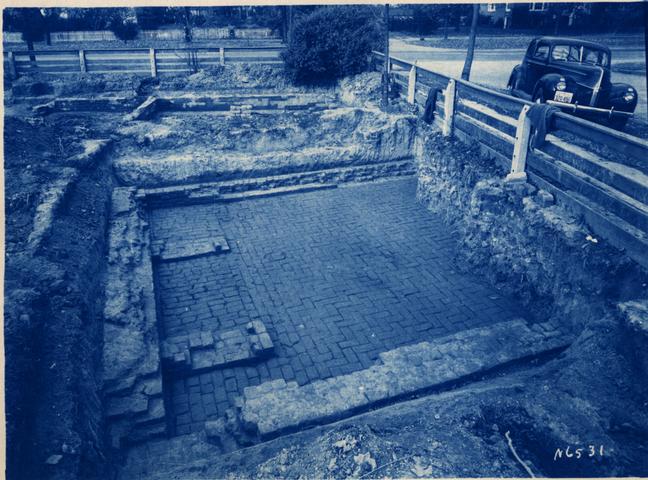 Photo #N6531
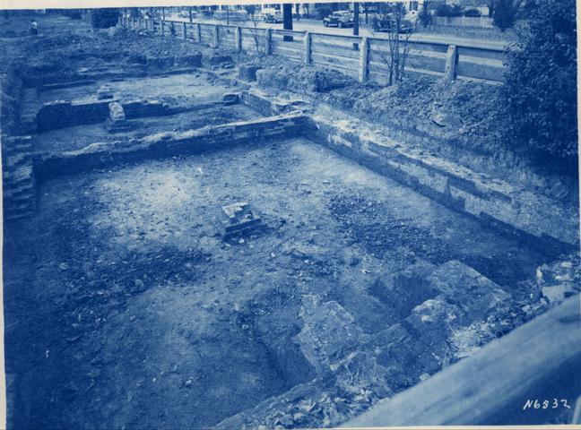 Photo #N6532
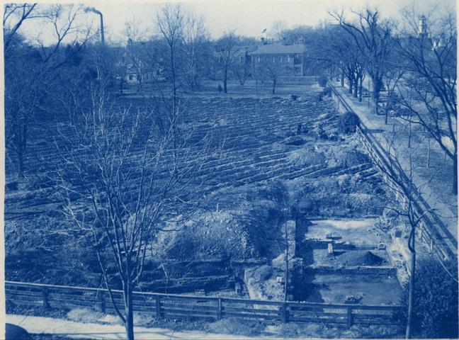 Photo #N6553
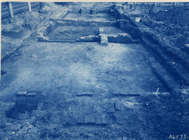 Photo #N6533
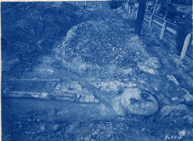 Photo #N6534
