Travis House Archaeological Report, Block 14 Building 4 Lot J & KOriginally entitled: "The Travis House Site Block 14, Area G
Colonial Lots J and K Report on 1962-1963 Archaeological Excavations Volume 1 (Part 1)"
Colonial Williamsburg Foundation Library Research Report Series - 1291
Colonial Williamsburg Foundation Library
Williamsburg, Virginia
1990
THE TRAVIS HOUSE SITE
Block 14, Area G
Colonial Lots J and K
REPORT ON 1962-1963 ARCHAEOLOGICAL EXCAVATIONS
Volume I (Part 1)
February 1963
Prepared by I. Noel Hume Drawing and Surveying by J. M. Knight
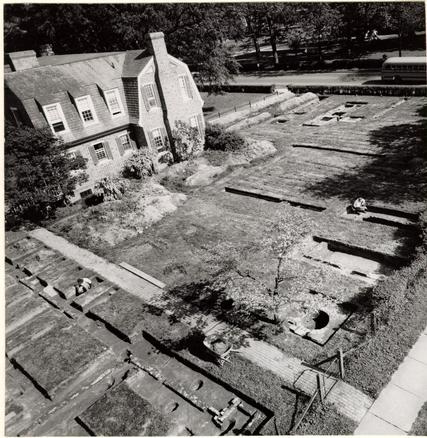 Frontispice. Colonial Lot J in course of excavation showing kitchen, well and nineteenth century smokehouse bordering South Henry Street, and Travis House east foundations in the background. Photo from the northwest. 62-DW-642.
CONTENTS
- Table of Figures
- Acknowledgments
- Explanatory note
- Introduction
- 1
- Precis of Travis House History
- 3
- Extracts from Humphrey Harwood's ledger
- 10
- The archaeology of the Travis House
- 15
- The Travis House, First Period
- 17
- The Travis House, Second Period
- 18
- The Travis House, Third Period
- 22
- The Travis House, Fourth Period
- 25
- The Travis House, Fifth Period
- 31
- The Travis House, Sixth Period
- 31
- The Travis House, Seventh Period
- 32
- The Travis House, porches
- 33
- The archaeology of the Travis House outbuildings
- 35
- The Northwest Outbuilding
- 36
- The Central North Outbuilding
- 38
- The Northeast Outbuilding
- 39
- The Well
- 42
- The Central West Outbuilding
- 44
- The Southwest Outbuilding
- 46
- The Central East Outbuilding
- 47
- The Southeast Outbuilding
- 47
- The archaeology of Colonial Lot K
- 47
- The cellar hole on Lot K
- 49
- The cellar hole and its bearing on the Travis House evolution
- 51
- The brick foundation on the J-K lot line
- 54
- Landscaping features on Colonial Lots J and K
- 57
- Brick Walks
- 58
- Planting
- 61
- Privies
- 62
- Fencelines
- 62
- Rubbish deposits
- 66
- Conclusions
- 69
- Conclusions The Travis House
- 70
- Conclusions The Travis House outbuildings
- 72
- Conclusions Landscaping
- 73
- Conclusions The artifacts
- 73
- Notes
- 75
- Appendix I, Table of brick sizes and mortar composition
- 81
- Appendix II, Summary of Excavation Register numbers mentioned in the text and illustrations
- 85
- Appendix III, Table of Excavation Register dating
- 96
- Figures
TABLE OF FIGURES
Frontispiece Aerial view of Colonial Lot J in course of excavation
Figure 1. Foundation plan of Travis House
Figure 2. Plan of Travis House North Outbuildings
Figure 3. Plan of Travis House West Outbuildings and garden
Figure 4. Plan of garden area immediately north of the Travis House
Figure 5. Plan of grid excavation at the south of Colonial Lot K
Figure 6. Sections through cellar hole on Colonial Lot K
Figure 7. Plan of trenching on Colonial Lot K, north of Figure 2
Figure 8. Plan of trenching north of the Travis North Outbuildings
Figure 9. Plan of northeast area of Colonial Lot J
Figure 10. Plan of 1962 excavations at 1/16" scale showing orientation of Figures 1, 2, 4-9
Figure 11. Plan showing distribution of artifacts linking Travis House Period IV with the Lot K cellar hole
Figure 12. Plan of foundation on Lot K and fencelines east of Travis House
Figure 13. Travis House insurance plants for 1796, 1809, 1815, 1823, 1830, 1838, 1846, and 1853
For excavation photographs see Volume I, Part 2, and for artifacts, Volume II.
ACKNOWLEDGMENTS
Because Colonial Williamsburg's archaeological section is but an extremely small part of a large and complex organization, it is inevitable that we rely strongly on the assistance of many people within our own Architectural Division as well as upon the personnel of other departments. We are, of course, extremely grateful to all of them. However, I wish to express particular appreciation to the following persons whose talents, counsel and labors have made this report possible: to Mr. J. M. Knight who was responsible for the site surveying and for the preparation of the plans that illustrate the report; to Miss Mary Stephenson whose research report on the Travis property was of inestimable value; to Mr. Paul Buchanan for the constant provision of information both architectural and historical; to Mr. G. Rossner who took many of the photographs; to my wife who has written the report on the Travis site artifacts; to Mr. John Dunton who has been responsible for the laboratory treatment of the finds; to Mr. Donald H. Parker and Mr. Alden Eaton for the provision of landscaping and mechanical facilities; to Messrs. Carter and Thompson for assisting Mr. Knight with the site survey; and finally to Mrs. William Bryant whose ability to create order out of the chaos of my original manuscript is beyond praise.
EXPLANATORY NOTE
The following report was prepared during the autumn of 1962 and while it contains all available archaeological information on Colonial Lot J, it does not cover the whole of the second Travis House lot (Colonial Lot K) as the eastern section presently lies beyond the bounds of the Superintendent's House (C.W. Research Department Offices) gardens. Limiting of the 1962 season's excavations to the garden area was a purely arbitrary decision intended only to provide a neat unit for this year's work. It was originally assumed that the remainder of that part of Block 14 (comprising the rest of Lot K as well as Colonial Lots L and M) facing Francis Street would be explored in 1963.
Because the final correlation of the evidence, both archaeological and historical, was dependent on the interrelationships between many diverse structures and artifacts, and because the basis for the conclusions was often extremely complex, the report has been written as a series of units, each with its attendant evidence. In so doing I have, of necessity, discussed possible associations, explanations and dating that are subsequently proved false when all these units are studied in relationship to each other. Consequently, theories put forward under the separate period and building headings should not be accepted without reference to the modifying conclusions that are provided towards the end of the report (pp. 51-54, 69-72).
The second draft of this report was reviewed by Mr. E. M. Frank and by Mr. Paul Buchanan in December, 1962, and their comments and suggestions have been noted in preparing the final manuscript. Mr. Buchanan frequently queried the absence of references to builders' hardware, flooring and significant plaster fragments that could be associated with the various structures. He was also disturbed to find few comments on archaeological evidence for the destruction dates of the buildings. The omission of these admittedly important factors was occasioned simply by the fact that in most cases neither the artifacts nor the dating evidence was forthcoming. Therefore, in using the report it must be understood that all the available archaeological information is included herein, but that when information was not forthcoming it has not been thought necessary to say so.
In an attempt to save time, the report was written while the excavations were still in progress and, consequently, before all the relevant information was available. The unsatisfactory results of such a course are firmly imbedded in these pages. Much space has been expended on arguments that subsequently proved to be unnecessary, while many factors have been given either too much or too little prominence. Ideally, it would be desirable to go back to the beginning and start again, but because time is so limited, this cannot now be done. The information contained in the report comprises all data garnered throughout the excavation, and it is to be hoped that at some future time the text will be edited and presented in a more orderly and readable form.
Archaeology, like most other disciplines, possesses a series of very basic rules, among which is the dictum that reports should never be published on the results of a season's work if the excavator intends to return later to continue the job. The only reason that the rule does not carry the corollary that a report should not be written while the digging is actually in progress is simply because the rule-builders never imagined that anyone would be that foolish. The present form of the Travis House archaeological report proves them wrong.
I.N.H.
February 19, 1963
ARCHAEOLOGICAL EXCAVATIONS ON THE TRAVIS
HOUSE SITE, COLONIAL LOTS J (I) & K
Introduction
Archaeological work on Block 14 was embarked upon in February 1962 as an obvious step towards the investigation of the southwest section of the town in the vicinity of the Eastern State Hospital, and in continuation of the digging carried out in 1961 in Block 15 on the site of the new United States Post Office. 1 The selection of Colonial Lots J (I) and K was partially influenced by the desire of Colonial Williamsburg to return the Travis House to the original site from which it had been removed in 1929. In addition, the northern sections of the two lots were being considered as potential parking areas and it was therefore desirable to complete their archaeological investigation before being sealed beneath a parking lot surface.
In the belief that the laying out of the parking areas was due to begin just as soon as the excavations could be completed, work commenced on the northern half of Lot J and the outbuildings thereon before clearing the foundations of the Travis House itself. However, for the sake of clarity, the following report will deal first with the residence and then with the outbuildings.
2The methods of excavation employed need not be discussed in detail. But it is worth recalling that this project saw the appearance of two innovations: first the application of a soil resistivity meter to locate buried foundations, and secondly the use of the dig as part of a student training course in the techniques of historic archaeology.
Most of the structures were located prior to excavation through the use of probes and the soil resistivity meter in conjunction with the numerous insurance plats illustrated in the Research Report on the Travis property. 2 (See Fig. 13) Lot J was dug in areas laid out to cover the known buildings, by careful test trenching, and by final cross-trenching in areas believed to be barren. Lot K, on the other hand, possessed few structural remains, had no insurance plats for guidance, but did hold out prospects of yielding important fencelines and other landscaping features. Consequently, the southern section of the lot was dug extremely carefully, using a 10'0" grid divided by 2 and 3 foot balks. The northern part of this lot promised to be less informative and was therefore cross-trenched after one E/W test cutting had been completed.
The Eastern State Hospital Superintendent's House that lies across the lot lines of Lots J and K on an E/W axis was constructed in 1928 after the colonial Travis House (which had previously served this purpose) had been removed. 3 Most of the modern house lies on 3 Colonial Lot K and, as a result, the archaeological excavation of that lot was divided into three segments around the building. Those at north and south of it have been mentioned above, while the third area to the east of the house can be quickly dismissed as of no importance. No colonial remains were found in the E/W test cutting or in the cross-trenching that flanked it. However, the area was not explored as thoroughly as the rest of the two lots owing to the fact that much of the ground had been disturbed by the laying of electrical and other utilities, and it was deemed unwise to dig too close to such lines.
Precis of Travis House History
Situated as it is within James City County, the loss of the Court Records leaves distressing gaps in the history of this property, particularly as it relates to the early years of the eighteenth century. 4
The first known owner was one Jonathan Druitt who was in Williamsburg as early as 1708 and whose will was filed in 1735, but it is not known when he acquired his three lots, J, K and L. We do know that he left the land to Richard Stayton, a minor, on the understanding that if the latter died before coming of age or without issue, the property should pass to the vestry of Bruton Patish to serve charitable ends. The lots did, in fact, become the property of the parish, and in 1762 a bill was introduced into the General Assembly to empower the Vestry 4 to dispose of it. The bill duly ground its way through the legal machinery of the colony and in October 1765, an act was presented ". . .to vest certain lots in the City of Williamsburg in the purchasers thereof. . .", wherein it stated that "Edward Champion Travis, gentleman, hath contracted and agreed with the vestry of the said parish for the purchase of two of the said lots, denoted in the plan of the said city by the letters I K; and James Blair, gentleman, hath also agreed for the purchase of one other of the said lots, denoted by the letter L; and they are now severally and respectively in possession of the said lots, and have built dwelling-houses, and made other improvements thereon." The act concluded with the normal proviso that its entry into law should be suspended ". . .until his majesty's approbation thereof shall be obtained."5
There is no record as to when, if ever, the Governor gave his signed approval to the act, but nevertheless it is clear that both Travis and Blair had taken the unusual step of erecting buildings on the lots even before the sale had been concluded. While the exact date of their construction is not known, an act of November 1762 stated that no buildings then existed on the lots.6 Thus any possibility that the present Travis House in its earliest form might have dated from the ownership of Jonathan Druitt is removed.
No evidence exists to show that Edward Travis ever resided in his house on Colonial Lot J and the lack 5 of outbuildings dating from its period of construction suggests that Travis built only to hold the property and that he may have either left it empty or rented it to a tenant. The almost total absence of excavated artifacts dating from the 1760's might indicate that there was no "intensive occupation" on the site at that time.
At a date prior to 1778, the Reverend William Bland purchased the property (Lots J and K) and in that year sold them to the Reverend Robert Andrews. In 1797 the latter disposed of the house and the two lots to Champion Travis, the son of the original builder. The property then remained in the Travis family until about 1830 at which date it was acquired by William Edloe. He subsequently sold it to a Baptist minister, Scervant Jones, in 1839, who conveyed it to the Eastern Asylum in about 1843. The lots then remained the property of the Eastern State Hospital and were occupied by its Superintendent until they passed to Colonial Williamsburg in June 1960.
Documentary sources relating to the two lots provide a good deal of useful information, although the majority of it relates only to the Travis House and its outbuildings, most, if not all, of which were situated on Lot J. However, the fact that the two lots were linked together as one property unit throughout their history suggests that structures on Lot K would have figured in insurance policies issued to the various owners of the 6 Travis House had they possessed substantial or valuable structures on it. The absence of any such identifiable references leaves one to suppose that Lot K was of no importance after about the 1790's. This date is derived in part from the Frenchman's Map of 1782 which shows a building on the lot facing Francis Street, coupled with archaeological evidence which will attempt to show that that structure had ceased to stand there by 1796.
The insurance plats for the Travis House property (Fig. 13) range in date from 1796 to 1860, some showing a reasonably accurate representation of the house and its outbuildings, while others confuse the issue with drawings that make no attempt to depict the positions or shapes of the structures. The plats provide the following information:
1796. A wood dwelling 70' x 20' plus a smoke house of wood measuring 20' x 10' and a store (?) of unspecified size, both shown at the rear of the lot.
1809. A carefully measured house described as "The dwelling house of wood and covered with wood. 76 feet front 20 feet at the east end and 17 feet at the west one Story high and occupied by Champion Travis." The projecting wing at the east end of the north wall is shown and the broken E/W line is given as "20 feet" plus "56 feet". Three outbuildings are shown at 7 the back of the lot, a kitchen at the west, laundry to the east (neither measured) and a smokehouse measuring 22' x 10' set between and behind them, 5' from the laundry and 22' from the kitchen. It may be assumed that the smokehouse is the same as the one insured in the policy of 1796, as in each case this was the only outbuilding insured.
1815. The plat shows the L-shaped return on the house, but includes it in an overall measurement of 20'. The smokehouse is again insured and again described as measuring 22' x 10'. This time, however, it is shown on the same line at the rear of the lot as two other unnamed outbuildings—presumably the kitchen and laundry. The plat does add, however, that the smokehouse was contiguous to these two adjacent structures.
1823. Here the dwelling house is without measurement as also is the smokehouse, though it is noted that the latter was "contiguous to two wood buildings".
1830. The plat measures nothing and only the dwelling house was insured, this being described as a "Dwelling of wood entire and two stories high." The sketch does, however, show three outbuildings in a row across the middle of the property and another in the N.W. corner. The only other information 8 provided is the statement that "The building A (residence) is not within thirty feet of any building."
1838. Here the house is stated to measure 74' x 16' with a 20' x 10' extension at the northeast end. This represents an accuracy not evident since 1809, but it may be significant that the total east end measurement was then 20'0", but is here increased to 26'0" (or 27'0" if the 16'0" is corrected to 17'0", the actual west end measurement). This change from 20' to 26' will figure in subsequent attempts to equate the archaeological evidence with the house history. The 1838 plat is also important in that it shows (without measurements) seven outbuildings arranged in a U to the rear of the residence. The three buildings of the 1815 plat are shown across the rear of the lot and are labelled "kitchen - out house - kitchen", the outhouse occupying the position of the smokehouse shown on all plats from 1796 to 1823. In addition, we now find a smokehouse and office on the South Henry Street property line south of the N.W. kitchen, as well as another smokehouse and a dairy south of the N.E. kitchen. The plat also notes that the residence "...is contiguous to seven wooden buildings, being in a line on contiguity within thirty feet of each other", a reversal 9 of the statement entered on the previous plat of 1830.
1846. This drawing is important in that, although no measurements are given, only five outbuildings are shown, leaving little doubt that those omitted are the rear "out house" and the west "smoke house" named on the previous policy plat. The two kitchens are now labelled each as a "wood dwelling", the office remains as before, while the east dairy and smokehouse are marked only as "small wood building[s]". The sketch also notes that the residence was not "...within thirty feet to any building of one hundred dollars in value."
1853. No significant changes appear here except that a well is sketched in between the two outbuildings on the South Henry Street property line. It was this evidence that enabled the well to be easily located once the foundations of those two buildings had been plotted. The plat still shows five buildings, but notes that the residence is "...contiguous to four wood buildings."
1860. This, the last plat, shows only the Travis House itself, but adds the note "Contiguity - 4 Wooden Buildings." Thus, one may suppose that few changes had occurred since 1853.
It will be seen from the foregoing summary of the insurance plat data that most of it relates to the 10 positioning of the various outbuildings. Foundations for five of these were found in the course of the 1962 excavations, the two that were not uncovered being those to the east (the dairy and smokehouse first identified in the 1838 plat) whose sites are believed to lie beneath the modern Superintendent's House, a building now occupied by the Colonial Williamsburg Research Department.
The only other important piece of documentary evidence is derived from the ledger of Humphrey Harwood, a Williamsburg builder, which contains entries under the name of the Reverend Robert Andrews for work and materials supplied between 1780 and 1790, i.e., within the period of Andrews' ownership of the Travis lots. As these entries are important to the arguments and deductions to follow, they are given here in their entirety.
Ms Ledger Humphrey Harwood
B, p. 34
| The Reverend Robert Andrews | Dr | ||
| 1780 | d | ||
| May | 22 | To 12 days work of my People Moveing House a 2/-old price_____ | £ 1. 4.- |
| 30 | To 6200 bricks a 27/6 Mo: 100 bushs of lime a 9d & 11 days labour a 2/- | 13. 7.6 | |
| To Building Chimney 65/ & underpining House 20/_____ | 4. 5.- | ||
| June | 1 | To 2 bushs of lime 1/6 & A bushel of Hair 1/6 & 2 days labour a 2/_____ | -. 7.- |
| To Repairing Larthing & plastering 15/_____ | -.15.- | ||
| 8 | To Whitewashing 2 Rooms a 3/9 & do Closets in D. House 3/9_____ | -.11.3 | |
| 1783 | |||
| The Above Account is to be paid att or for one | £20. 4.9 | ||
| The present Depreciation £2000 | |||
| 11 | |||
| th | |||
| May | 14 | To 5 bushls of Lime a 1/_____ | -. 5.- |
| To Repairing Plastering 5/ & 1 Days labour 3/ & hair 6/_____ | -. 8.6 | ||
| To whitewashing 1 Room & a 2 passage a 3/_____ | -.15.- | ||
| th | To Do 3 Rooms a 3/ & 4 Closets a 1/6__ | -.15.- | |
| 21 | To 5 bushs of Lime (Rong Charge) | ||
| To whitewashing 3 Ceilings one Room & 3 Closets | |||
| To do 2 passages & 1 Stairway & plastering 2 fire places | £22. 7.8 | ||
| To 1 peck of hair & 2 Days labour (Carried to folio 76) | |||
| 1785 | th | ||
| Januay | 5 | To 220 bricks 6/ & 4 bushels of lime a 1/ & lats work 3/_____ | £ -.13.- |
| To laying an Harth 2/6 & setting up a Grate 7/6_____ | -.10.- | ||
| To setting up a Grate (up stairs) 3/6_ | -. 3.6 | ||
| Decemr | 9 | To 2 bushels of Mortar 2/ & pinting Chimney 3/_____ | -. 5.- |
| 1786 | |||
| Januy | 24 | To 5 bushels of lime 5/ & 350 Bricks a 3/ & 1 days lar 2/6_____ | -.18.- |
| To underpining 2 sides to Smokehouse, building Well hole & Working over plates 10/_____ | -.10.- | ||
| May | 6 | To 750 Bricks a 3/ pr C & 16 bushels of lime a 1/_____ | -.18.6 |
| To underpining Smoke-house 12/_____ | -.12.- | ||
| To repairing plastering in House 5/9 & hair 9d_____ | -. 5.9 | ||
| To 2 days of labourers work 5/_____ | -. 5.- | ||
| 14 | To White-washing 2 passages 9/ & do Ceiling & Closet 4/6_____ | -.13.6 | |
| 1787 | |||
| June | 27 | To 24 bushels of lime a 1/ & 664 bricks 2/_____ | 2. 4.- |
| To 3 1/2 days labour a 2/6 & hair 1/__ | -.10.9 | ||
| To underpining porch 10/_____ | -.10.- | ||
| To lathing & plastering 20 yds in shead a 6d_____ | -.10.- | ||
| To re-building steps to Cellar 12/_____ | -.12.- | ||
| To do Jambs of Chimney 2/6_____ | -. 2.6 | ||
| Octor | 8 | To 6 bushels of lime 6/ & 150 Bricks 4/6_____ | -.10.6 |
| To setting up a Grate 7/6 & repairing Cellar Wall 2/6_____ | -.15.- | ||
| 12 | |||
| 1788 | To labours work 3/6_____ | -. 3.6 | |
| May | 9 | To lime & Repairing plastering 2/ 3/4 bus Whtwash 1/6_____ | -. 3.6 |
| To wht washing 3 Cealing a 2/6 & 1 Room & 2 passages a 4/6_____ | 1. 1.- | ||
| 1789 | |||
| Sept | 15 | To lime 1/6—6- bricks 2/ mendg yr back & layg an Hearth 3/_____ | -. 6.6 |
| 1790 | |||
| Jan | 26 | To cash to ball_____ | -. 1.6 |
| £14. -.- | |||
A number of deductions can be made on the basis of these entries, the most important being that between May 22nd and June 8th, 1780, Harwood moved a house for the Reverend Andrews. It may be suggested that it was not a very large house, as the number of bricks used in underpinning it and erecting its chimney was quite small. However, it might be argued that other bricks would have been salvaged from the structure's original foundations and thus cutting down the number supplied by Harwood. More positive is the evidence that the moved building did not have a basement beneath it, for Harwood charged only for "underpining House 20/-". On June 8th, he entered a charge "To Whitewashing 2 Rooms a 3/9 & do Closets in D. House 3/9" and it may be supposed that as Harwood refers to the dwelling house, that it was not the same structure that he had moved. It may be wondered, therefore, whether there might have been a connection between the two jobs occasioned, perhaps, by attaching the moved house to the end of the dwelling house and thus necessitating repairs to one downstairs room and two closets, and to one room above. If this were so, then 13 one might here have evidence of the attachment of an aditional section to the east end of the Travis House. 7
This would logically be the part that did not fit the basic rectangular plan, i.e., the 20' x 20' first shown on the insurance plat of 1809.
The later entries refer to underpinning a smokehouse and "building Well hole" (1786), without, incidentally, any charges for bricks for the latter. In the following year, we find repairs to a cellar and to a porch, both of which were presumably associated with the Travis House itself. Although numerous charges were billed to the Reverend Andrews, it is notable that all were small and related to minor repairs. But because the work done by Harwood through the period 1780 to 1790 seems to have been fairly consistent, it might be deduced that Andrews found him satisfactory and that he would have made use of his services whenever occasion presented itself. If this reasoning is sound, it follows that the only major building operation that occurred on Lots J and K during that time was the house-moving job of 1780. 8
With the above thinking in mind, one must return to the evidence of the Frenchman's Map which is assumed (for want of evidence to the contrary) to have been completed in 1782. On it the Travis House appears, when scaled, to measure only 52'0" in length. Is this, we might wonder, a cartographer's error, or was the house actually 18'0" shorter than it was when the first insurance plat 14 was drawn in 1796? As there is only approximately 2'0" variation between the length of the west end of the house as shown by the "Frenchman" and the excavated foundation, an error of 18'0" seems improbable.
It should also be noted that the "Frenchman" provides the only documentation for a building on Lot K and that he shows it to measure approximately 17'0" x 22'0" and to lie on the same building line as the Travis House itself. Thus if one were to move the building on Lot K and attach it to the east end of the residence, the latter would attain a total length of about 74'3", four feet more than the stated measurement of the 1796 plat, but only two feet less than the seemingly careful measuring of 1809, and within three inches of the actual length from S.W. corner to S.E. corner, if the west chimney (1'9" in exterior depth) is omitted.
It is tempting to try to equate the moving of a building by Harwood in 1780 with the increase in size of the Travis House prior to 1796. But such a theory begins to leak when we find the structure on Lot K (the most probable candidate) still in position when the "Frenchman" made his map in 1782. An examination of Harwood's ledger gives no indication that the entry was misdated and the suggestion that the Frenchman's Map was originally deliniated prior to 1782 finds no credence in the ranks of the C.W. Research Department. Such a map, they argue, would not have been made for any other purpose 15 than the billeting of troops and there would have been no call for this prior to the autumn of 1781. It was at that time that a team of French cartographers under the direction of Col. Desandrouan made numerous maps of the Jamestown-Williamsburg-Yorktown section of the peninsula, making it the most probable period for the drawing of the Williamsburg town map.
In December and January 1962-3 the mutilated remains of another building were found lying between the "Frenchman's" building on Lot K and the Travis House. Archaeological evidence indicated that the structure was in existence as late as March 1775, but its absence from the map indicates a terminal date prior to 1782. Although the shape of the building has not been fully determined, it is possible that it was, at least in part, of comparable proportions to those of the Northwest Outbuilding which is known to have been built or located between 1770 and 1782. It might, therefore, be suggested that the Northwest Outbuilding was moved from Lot K and it was this that figured in Harwood's bill of 1780.
The Archaeology of the Travis House
Before work on the site began it was assumed that the excavation of the dwelling house foundations would be a simple routine operation presenting no serious problems. After all, the house had stood until 1929 and had been moved by Colonial Williamsburg, having first been drawn 9 and photographed. Consequently, there was no reason to 16 suppose that anything new would be learned.
The photographs proved to be disappointing in that they were not taken until the building had already been partially dismantled and none showed details of the construction. It did seem, however, that one could expect to encounter a basement under the entire length of the structure as window openings were shown all along the brick foundations from west to east. The plan of the building's basement after moving10 showed provision for a bulkhead at the east end and so, when excavation began in that area of the original foundation, it was expected that a basement would be found. But regardless of the window grill openings and the inferred bulkhead, no basement was encountered. Thus the first thorny question mark arose—why would the grill openings be set into the brick underpinning if no basement existed?
With that question still unanswered, the excavators next turned their attention to the west end of the house and began to clear the foundations from west to east. The results of this work became increasingly confusing as the operation progressed. One factor, however, was quickly apparent; the house had been built up in a number of none too easy stages and so presented an archaeological problem of considerable complexity. I do not propose to chronicle each step of the digging; to do so would merely make this report as rambling and confused as were the excavators when each day's clearance only increased their problems. Instead 17 I propose to discuss in turn the successive stages of construction, noting only those factors that contributed to the final conclusions.
Travis House, First Period
The building was found to measure approximately 31'0" x 17'0"11 with an interior chimney at the west end approximately 6'0" in width, flanked by a pair of closets having interior foundation measurements of about 4'9" x 2'6" (Part 2, figs. 3 & 4). There was one room on the first floor with a large stairhall, presumably of the same size as that to be seen in the present building. This hall had matching entrances at north and south, each approached from a small stoop (6'9" x 4'9") with curving steps on apsidal brick foundations (Part 2, figs. 6, 7, & 8). The stoop apparently possessed an A-roof as a brick rubble and mortar-filled guttering trench (Part 2, fig. 7) was found on either side of the foundation and extending the full length of the building's south wall. The house had a substantial basement beneath it, extending from a point immediately east of the chimney to the east wall, providing interior dimensions of 24'6" x 14'9". The basement was approached through a bulkhead in the east wall, a feature which was subsequently totally destroyed when the cellars were enlarged in an easterly direction (see Second Period).
Foundation walls of the first period structure were 1'1" in thickness except at the west end where the 18 closet walls measured only 8-9" in width. However, as the 1'1" foundation wall continued N/S immediately east of the chimney, it may be supposed that the closets only reached to first floor ceiling height and that the chimney became an exterior feature above them. Consequently, it might be more accurate to describe the house as measuring only 27'9" in length with an exterior chimney and flanking ancillary closets; although it must be noted that there was no evidence to show that the closets were not built at the same time as the rest of the First Period house. (For brick sizes and mortar composition see Appendix I.)
Dating for the construction of the First Period dwelling house is derived almost entirely from historical evidence (see p. 3) and we must suppose that it was erected at some time between 1762 and 1766. Archaeological evidence is scant and comes only from the filling of the previously mentioned guttering trench12 west of the south stoop and running west along the south face of the house. In this was found a considerable quantity of coarse, redbrick pantiles along with scraps of pottery and glass, indicating a deposition no earlier than 1750 and probably not before 1760. The latter would, of course, be consistent with the documentary evidence that indicates a construction date of around 1763.
Travis House, Second Period
At some date before the Frenchman's Map was drawn, the length of the house was almost doubled by an addition 19 to the east end, which not only increased the living space, but also added an area 18'11" x 15'9" to the basement. To achieve this, the 1'1" foundation walls were extended 20'0" to the east with an exterior chimney measuring 5'3" x 2'10" being bonded into the east wall. It is important to note that when the hole for the basement was dug out, the excavation was 22'6" in E/W length, 2'6" longer than it should have been (Part 2, fig. 13). In consequence, considerable back-filling was required outside the new east foundation and, more important to the builder, the chimney foundation had to be carried all the way to the basement floor, thus using many more bricks than would have been necessary if the cellar hole had been dug the right size. The backfilling east of the foundation contained one fragment of wine bottle,13 but its date was similar to the pieces found in the First Period guttering trench and therefore it is of no dating significance. It is important to note that the top two surviving brick courses at the new east end possessed scored mortar joints, thus leaving no doubt that initially, at least, this was an exterior face.
The building of the basement extension naturally entailed the destruction of the original east bulkhead (which subsequently became a doorway between the two cellars) and the construction of a new bulkhead and steps at the north east end of the Period Two addition (Part 2, figs. 10 & 11). The bulkhead possessed six steps, originally with wooden nosings, each step measuring approximately 1'0" in 20 width and 7 1/2" in depth. A section of the brick cellar floor immediately south of the bulkhead was taken up and found to be seated on 5" of dirty clay and brickbats from which came fragments from the base of a delftware punch-bowl dating from the mid-eighteenth century as well as a sherd from a Westerwald tankard of good quality (E.R. 658). Running along the north wall face and turning south against the east wall was a shallow trough having an average width of 1'1". The clay beneath was hard-packed and the bottom was lined with powdered brick. As the trough terminates at the same depth as the bottom of the brick walls (three courses below the surface of the brick cellar floor), it is probable that this was created when the wall was being built and that the brick dust stemmed from that operation. A similar condition was noted against the west interior cellar wall at the Peter Scott site. It is possible that boards were laid in the trough to prevent the bricklayers from wallowing in the wet clay while the walls were being erected, and that these boards caused the even and smooth compression of the clay at the bottom of the depression.
At about the same time that the Second Period extension was added a new north porch was erected, rectangular in plan and measuring approximately 11'10" x 10'2" (with steps) and overlying the original apsidal step foundation.
Another change which may have occurred during Period Two effected a Period One guttering ditch along the 21 north wall comparable to the previously discussed brickfilled cutting against the south foundation. The north cutting differed from that at the south in that instead of containing brick and tile debris it was packed with heavy yellow clay overlying a 3" bed of oyster shells (Part 2, fig. 5). At some time following the construction of the Second Period bulkhead, a new guttering ditch (also packed with heavy water resistant clay) was begun from its west cheek and extended in a westerly direction and passing through and beyond the Period One porch foundation. However, as the Period One guttering ditch began at the west face of the first porch, the later ditch diggers found themselves extracting the already adequate gutter packing prior to putting back precisely the same material for the same purpose. It seems that while the work was in progress, someone discovered what was happening and the excavating was stopped 5'0" west of the first porch (Part 2, fig. 9). Thus, because the later trench was 1'0" narrower than the original, its end could clearly be seen seated inside the Period One guttering. 14
Before leaving the matter of the guttering trenches, it must be recorded (without explanation) that while these features ran the full length of the First and Second Period north Walls, no such treatment was afforded the Period Two south foundation east of the porch.
Travis House, Third Period
It is here that the chronology of the house begins to become confused. But in considering the possible evolution starting at this point, it is useful to bear in mind that the combined E/W length of Periods One and Two (less the chimneys) was 50'9", or 1'3" short of the building's length as shown on the Frenchman's Map of 1782.15
The Third Period addition comprised a pair of closets attached to the east end, with an 8" brick foundation enclosing the Period Two east chimney, i.e., creating a new east wall beyond the chimney (Part 2, figs. 13 & 15). The foundations of the extension abutted against the Period Two east wall obscuring the previously mentioned scored mortar jointing, and creating interior closet space measuring approximately 5'0" x 2'9". With the addition of these closets the total length of the building (less the west chimney) amounted to 54'3", 2'3" more than was indicated by the Frenchman's Map. However, as this showed the width of the house to have been 19'0" when we know it to have been 17'0", we must accept the fact that the map has an error of at least 2'0" and admit that on the evidence so far presented, it is impossible to determine whether the cartographer was measuring the structure before or after the east closets were added.
Archaeological clues to the construction date of the closets are forthcoming, but unfortunately, most of them are more confusing than helpful. First, we must consider the presence of one unusual triangular padlock 23 and two pieces of possibly eighteenth century glass found in dirty soil 16 sealed beneath the east wall of the south closet. Two examples of this padlock had previously been found, one at the Challis pottery kiln site in James City County in a context of about 1730, 17 and the other in a well on the Anthony Hay site in a deposit of about 1810-1820. 18 Thus, our inability to date the Travis lock any more closely than that neatly renders it useless.
Protruding from beneath the same foundation that covered the padlock was part of a Canton porcelain plate that could not have been imported before about 1810. Two inches of the plate lay under the foundation, while about four projected into the closet area, and it is debatable whether the sherd could have worked its way or been pushed under the foundation from the inside of the closet. Be this as it may, the fact remains that the piece joined onto other fragments of the same plate (Vol. II, fig. 15A no. 1.) that were overlying a stratum of brick rubble in the bottom of the closet foundation.
Among the many artifacts found beneath the southeast closet 19 were a naval (?) pistol barrel, a Federal naval or Marine button, a pearlware saucer marked Davenport (1793-1830), a wide range of transfer-printed pearl bodies including a black-printed romantic mediaeval scene marked on the back "Chevalerie". Also present were cup and saucer fragments decorated with "seaweed" pattern in overglaze red. Sherds of this ware were present in numerous 24 contexts around the Travis House outbuildings 20 as well as in the shop basement across South Henry Street in Archaeological Area 15B 21. The "Chevalerie" pattern was also widely distributed through the Travis House lot, 22 but did not appear outside it. But the most significant dating evidence was provided by the presence of a Sandwich pressed glass saucer with a design depicting the paddle-wheeled sailing vessel "Benjamin Franklin". This is a well-known form and one that is attributed to a date no earlier than 1830. 23 There can be no denying, therefore that a quantity of somewhat curiously varied trash was deposited within the area of the southeast closet at some time after 1830. 24
The deposition of refuse inside a closet foundation is surprising, but not entirely inexplicable. Less easy to explain is the fact that one fragment (see previous page) lay partially beneath the foundation and that other joining sherds were found in a depression abutting against the exterior southeast corner of the closet. This evidence on its own would strongly suggest that the closet foundation was laid after 1830; yet such a construction is entirely at variance with the rest of the evidence, both archaeological and documentary. It might, therefore, be supposed that this section of the building was stripped and repaired in the nineteenth century.
It was, and still is, my belief that because the closet foundation continued across the entire east end of 25 the building, there was reason to believe that this addition did not merely represent a one story lean-to appendix on either side of the chimney, but was carried to roof height, enlarging the upstairs east chamber by adding interior space on either side of the chimney; in short, creating an entirely new east end to the house. This contention is supported by the fact that an old corner board rising to roof height still existed in 1928 25 at a point identical to the closet corner as indicated by the excavated foundations. If the Period Three east wall had only been taken to first floor ceiling height, it is reasonable to suppose that such slight construction would have been stripped out when the final east addition was added and that instead, the corner board would have been placed at the Period Two east end. However, this reasoning has been challenged on the grounds that the foundation (one brick in thickness) is too light to have carried a wall take to the height suggested. In defence of the theory it might be noted that the large Anthony Hay cabinet shop on Nicholson Street 26 stood entirely on foundations of that width, and also that the Period Two chimney was of sufficient size to provide useful support for any timber wall erected against it.
Travis House, Fourth Period
This phase entailed major changes to both the east and west ends of the house, and while the nature of those alterations is described below, the reasoning that links them together is highly complex and is dependent on 26 a prior understanding of the archaeology of the "Frenchman's" building on Colonial Lot K. Consequently, such factors as the dating and argument pointing to the origin of the Period Four easterly extension of the Travis House are deferred to a later section of this report (see p. 51 ff and fig. 11).
The east addition survived in the ground as an extension running from the southeast closet for a distance of 20'0" and then returning on a north/south line to form a new and final east end to the building. The southern stretch was roughly laid with shell mortar in haphazard bond, one brick in thickness, and this construction continued in the east foundation until it was cut through by two modern pipes at a point on, and immediately north of, the 17'0" mark. The latter, being on the north building line for the rest of the building, could not have been disturbed at a more inappropriate point. However, a straight joint did show at 16'6" (though the wall was only four courses deep at that point), and it is possible that the north/south wall originally ended there. However, beyond the damaged section, the foundation continued, using bricks, mortar and bond that conformed reasonably well to the haphazard appearance of the southern section. The total east wall was 26'6" in length. It then turned west for a distance of 23'7", finally turning south again for a stretch 9'3" in length which terminated against the western end of the north foundation of the northeast closet 27 (Part 2, fig. 15). An interior chimney measuring 5'2" x 2'6" was divided from the Period Two east chimney only by the 8 1/2" brick foundation of the Period Three east end. The brickwork and mortar of the chimney was paralleled by that of two piers, one projecting east from the north closet's northeast corner and the other abutting against the Period Four east wall, its northern face on the 17'0" building line. The presence of the piers on the same line as the north building line of Periods One, Two and Three suggests that the Period Four addition originally measured only 20'0" x 17'0" (Part 2, fig. 18).
It will be remembered that the total measurements of the house in Period Three were close to those given by the "Frenchman" and that I am assuming that the map portrays the building in its second or third stages. Consequently, the Frenchman's Map has no bearing on any subsequent phase of the house history.
The rebuilding of the west wall (which will be discussed later in this section) coupled with the eastern extension, gave the house a total length of 74'3" or 76'0" including the new west chimney. Now the first insurance plat (1796, fig. 13A) showed the building as having total measurements of 70'0" x 20'0". As those dimensions fit none of the known periods of construction, it must be supposed that they were derived from a very rough pacing. Nevertheless, it is more probable that such measurements would have served a building measuring 74'3" x 28 17'0" than one of 55'4" x 17'0" as it would have been after the addition of the east closets in Period Three. Therefore, it seems probable that the house had grown to its full length by 1796.27
The next insurance plat (1809, fig. 13A) is, as has previously been noted, the most carefully measured of them all. It gives the correct west measurement of 17'0" and the right south length of 76'0", but the east wall is shown to measure 20'0", thus extending 3'0" beyond the original 17'0" building line. It then returns west for a distance of 20'0", the correct length of the Period Four addition as revealed by excavation. Because all the measurements save the east wall fit the archaeological evidence, I contend that the east wall's stated 20'0" is also correct. However, there is no surviving archaeological evidence for a return at the 20'0" mark, the two possible points being at approximately 17'0" and at 26'9". Having weighed the evidence, I suggest that the Period Four addition measured 20'0" by about 17'0" and that the back wall originally stood on piers.28 Then, at some time prior to 1809, a northerly extension of 3'0" was added, and later disappeared when the back wall was further extended to 26'9".
Little or no direct archaeological evidence was forthcoming to help date the construction of the Period Four addition, as the entire interior filling had been disturbed in the nineteenth and twentieth centuries. The only artifacts found beneath the foundations were under 29 the east wall and formed part of an oyster and trash filling to a gully that sloped in an easterly direction, a deposit that contained bottle seals bearing the initials BIK, identical to others from a cellar hole in Archaeological Area 15A29, and filled around 1765.
Changes to the west end of the house entailed the destruction of the First Period west wall, closets and interior chimney, and the erection of a 2'0" brick west wall and another exterior chimney measuring 4'2" x 1'9" (Part 2, figs. 3 & 4). This was the only alteration to that end of the building throughout its life, and the room so created still survives. During the entire period of actual excavation we were of the opinion that the rebuilding of the west wall occurred at the same time that the new Third Period end and closets were added to the east. Evidence seemingly in support of this theory came from a scaffold pole hole30 outside the southeast corner of the Period Three south closet in whose filling was found an engraved wine glass identical in shape and ornament to fragments of another discovered in the back-filling of the builder's trench for the rebuilt west wall.31 The closest parallel for the engraving is to be seen on a glass found between the floor joists of an old house less than two miles from the Amelung glass factory site near Frederick, Maryland.32 A large quantity of other artifacts was found in the wall's builder's trench, among them Chinese export porcelain cups and saucers, part of 30 a Caughly transfer-printed porcelain saucer dating around 1775-1785,33 a dry-bodied blackware teapot with a pseudo-Chinese mark attributable to John Astbury,34 numerous fragments of creamware of varying quality, one sherd of Colono-Indian pottery,35 and various wine bottle fragments dating up to about 1770-1780. In addition, there were numerous pieces of table glass, such as tumblers, decanters and salvers; also a neck fragment from a small ribbed flask, another joining piece of which was discovered in a layer of ash and domestic refuse south of the Period Four east extension.36
The presence of the ash layer, the fragments in the west builder's trench and the glass from the scaffold pole hole together suggested that the rebuilding of both ends occurred at the same time. But the entire theory was built on the assumption that the scaffold pole was set in its hole when the Period Three closets were being constructed. When this was proved wrong, the rest of the thesis collapsed. Further damage was provided by the discovery of another scaffold pole hole against the south face of the house below the end board marking the junction of Periods One and Two. This hole contained a large fragment of blue-edged pearl-ware37 that could not have dated prior to 1785 and probably somewhat later.
When the evidence of the building on Lot K was sufficiently studied (see p.51), it became apparent that the scaffold poles were erected when the Period Four extension 31 was added to the east of the Period Three closets. So, as the glass in the scaffold pole hole was linked to the builder's trench for the west wall, all three must have been contemporary.
Travis House, Fifth Period
This change is poorly established and consists only of the 3'0" projection to the north of the Period Four extension beyond the 17'0" building line of Periods One, Two and Three. The tenuous evidence has already been outlined above.
Travis House, Sixth Period
This phase again relates only to the northerly extension which by the period 1810-1820 had been enlarged (using haphazard bond and shell mortar) to project 9'6" north of the 17'0" line. Unfortunately, documentary support for this measurement is not forthcoming until 183838 when the insurance plat of that year (Fig. 13C) shows the main body of the house measuring 74'0" x 16'0" and the rear addition noted as 20" x 10". As all the basic measurements are correct to within a foot, it may be accepted that the given depth of the addition is of similar accuracy.
Archaeological evidence showed that before the new north wall was laid, instead of digging a builder's trench, the entire area within the proposed foundation was cut out, enabling the bricks to be laid against the dirt face by workmen standing inside the foundation area. But as had happened twice before in the history of the 32 Travis House, the digging labor was not properly aware of the builder's requirements. As a result, the foundation hole was dug 1'2" too wide at the west, making it necessary for this space to be back-filled after the foundation was completed (Part 2, fig. 16). The fill proved to be a mixture of coal ash and broken ceramics and glassware.39 The majority of the items could have had a terminal date of c. 1800, but a few sherds suggest a terminus post quem after 1810. It should be noted (for whatever it may be worth) that a fragment from a pearlware saucer found in a back-filling joined to another from an ash layer inside the Period Three north closet.40 The latter deposit also included a fragment of a very small blue-edged pearlware saucer similar to an almost complete example found in the filling of the south closet.41 The presence of crossmending artifacts inside and outside both closet foundations has not been explained and, consequently, is somewhat disturbing.
Travis House, Seventh Period
The final major change entailed the building on piers of another addition to the northern extension at the east end of the house, thus giving the east face a total length of 43'0". Only one pier (at the northeast corner ot the Period Five extension), plus a scatter of brick dust marked the site of this feature (Part 2, fig. 18). The bricks and cement suggested a date in the late-nineteenth or in the present century, but beyond that, no archaeological information was forthcoming.42
Travis House Porches
Just as the appearance of the dwelling house itself changed dramatically through the years, so also did the porches at back and front. But as there is little dating evidence for these features other than the fact that one succeeded another, it was impossible definitely to associate their evolution with that of the body of the house. Furthermore, there is no documentary evidence to describe or indicate the size of any of them. The first porches were apparently built along with the primary structure (Period One) and these comprised small rectangular stoops at north and south of the hall, each approached from semicircular steps (see p. 17 and Part 2, figs. 2, 6-8 & 10). In Period Two the front porch remained the same (as it probably continued to do until the nineteenth century), but the rear porch was dismantled and a larger rectangular structure erected, whose east end extended beyond the junction of the Periods One and Two north walls. This second north porch was approached from two or three rectangular steps that extended across its entire width.43
The next change is likely to have taken place either in the later years of the eighteenth century or in the early-nineteenth, and comprised the rebuilding of the north porch and extending it eastward from the Period One north doorway to within 6" of the Period Two bulkhead. The porch stood on L-shaped piers, and terminated at the west on the same line as had the previous structure. No 34 evidence of steps was identified, though it is possible that the porch was approached up the same short flight that had served its predecessor. A brick walkway extended north from the porch and ran all the way to the north outbuildings, but it was impossible to be sure whether it was constructed during the life of the second or third porch. It could only be determined that it was not associated with the Period One porch, as a line projected down its center did not pass through the mid-point of the semicircular north steps.
The third north porch piers (Part 2, figs. 8 & 10) were set on pads of shell mortar and the same compound was used to bond the bricks; otherwise there was no clue as to its date. We do know, however, that this porch survived until the house was moved from the site in 1929, although it had been extended to create a small room at its west end earlier in the present century. 44
The south porch of Period One seems to have lasted until well into the nineteenth century when a new rectangular stoop was constructed. This may have extended only to a width of 11'6" at the outset; but as a pier using similar bricks and yellow sandy mortar was situated on the same line 23'6" further east, it is more probable that these were the foundations of an extensive verandah running along the front of the house and having a total length of about 35'0". In this case the 11'6" measurement was probably only that of the step foundation. As 35 the latter lay against the south edge of the excavation and tight against the boxwood hedge, it was decided not to explore the remains further. However, it is believed that additional traces of steps might survive, extending south to the present sidewalk.
Travis House, Conclusions
The building as it stood in 1928 incorporated at least seven different structural changes, each of which had increased the size of the original house that had been erected in about 1763. But as its evolution is dependent on evidence from Lot K not yet discussed, the summary of the house chronology is deferred to p. 71.
The Archaeology of the Travis House Outbuildings
The historical evidence for the evolution of the outbuildings has already been explored, and it will be recalled that the nineteenth century insurance plats were often extremely informative not only in locating the positions of the buildings, but also in identifying their purpose. Only rarely, however, were measurements given, and statements regarding contiguity were contradictory, while measurements between the structures did not check out with those revealed by excavation.
The earliest illustration of the Travis House and its outbuildings is still the Frenchman's Map, and this shows only two of the dependencies, that to the west measuring approximately 22'0" x 17'0" and another to the east measuring approximately 27'0" x 18'0". These dimensions 36 fit none of the structures whose foundations have been found to the rear of Lot J. While the position of the Northwest Outbuilding, whose foundations were exposed in the course of the 1962 excavations more or less coincide with that shown by the "Frenchman", the latter's northeast building differs from the located foundation by some 32'0". This is too great a difference to be dismissed as a mapmaker's error. Furthermore, post holes beneath the excavated Northeast Outbuilding foundation contained artifacts that could not have been deposited before 1790 and probably not before c. 1800. But while this foundation could not, therefore, have been the one shown on the Frenchman's Map, it was disturbing to find no trace of an earlier structure on or near the cartographer's indicated location. But while the archaeological evidence does not resolve this problem, it does show that not one of the three North Outbuildings whose foundations were found could have dated prior to c. 1770 (see below). Consequently, we must either assume that the Travis House had no outbuildings in its First Period, or that all traces of such structures have since been obliterated. One point, however, is irrefutable, an east/west fence existed up to about 1770 on a line that was subsequently sealed beneath the foundations of all three North Outbuildings.
The Northwest Outbuilding (Fig. 2)
This building revealed traces of three different periods of construction, the earliest (post c. 1770) measuring 37 approximately 16'3" x 12'0", 45 with foundations one brick thick, using shell mortar and laid in English bond. It had an exterior chimney at the west end measuring 8'6" x 3'10" and 14" in thickness, whose south cheek had been cut through and replaced with another reducing the width of the hearth from 6'3" to 5'5". The reason for this addition was apparently to add either a bake oven or an exterior boiling unit. This addition entailed the removal of the S.W. corner foundation of the building and the construction of a boxlike footing 3'10" in width and projecting 2'3" to the south. The bricks were roughly laid, but used shell mortar and were similar in color to those in the earlier foundation.
Dating evidence for the building's construction was provided by the presence of creamware (not yet identified in Williamsburg before 1769) in the filled post holes that lay inside it and beneath its east footing, and also by the presence of a considerable quantity of pottery of about the same period from soil beneath the building's interior that had not been disturbed during its life.
The third phase of this structure occurred well into the nineteenth century when a comparatively substantial addition, raised on piers, was appended to the back of the building, complete with its own small west chimney. The bricks were a hard pink and the lime mortar sandy yellow with occasional intrusive traces of shell. Only the southeast pier and a short section of the north foundation 38 was found, but assuming that the west wall would have continued on the same line as that of the original section, it may be deduced that the nineteenth century addition measured approximately 10'0" x 16'0".
A quantity of early nineteenth century pottery was found immediately outside the north wall of the first structure and among the pieces was a fragment of a pearlware tureen, 46 which joined onto another larger sherd that was found in the post 1830 assemblage inside the foundation of the Travis House southeast closet. All one can say of this is that the outbuilding's northern extension cannot, therefore, have been built before 1830.
The insurance plat for 1796 (Fig. 13A) shows this building as a store, the 1809 plat marks it as a kitchen, as also does the plat of 1838. In 1846 it was called a "wood dwelling", and in 1853 a "wood building", while the final plat of 1860 said nothing, as none of the outbuildings were marked.
Central North Outbuilding (Fig. 2 and Part 2, figs. 25-27)
This foundation, which did not appear on the Frenchman's Map, had been much mutilated, but it was still possible to establish its approximate dimensions as being 22'0" x 10'0", exactly corresponding with those given in the 1809 and 1815 insurance plats, but two feet longer than indicated on the plat of 1796.
The foundations were one brick in thickness, used shell mortar, and were laid in English bond. No 39 traces of a chimney were found, an omission that was hardly surprising in view of the fact that the plats of 1796, 1809, 1815 and 1823 all labelled it a smokehouse. In 1838 it was described as an "out house". As it failed to be shown on any subsequent plat, we may safely assume that the building had ceased to exist by 1846. 47
Northeast Outbuilding (Fig. 2 and Part 2, fig. 28)
There is no likelihood that the excavated foundation is the same as that shown on the Frenchman's Map. The latter provides dimensions of 27'0" x 18'0", a far cry from the actual measurements of 20'0" x 16'0", although it could, of course, be argued that the inclusion of the chimney foundation would increase the length to 24'3" and bring it close to the 2'0" error that seems to have been present on the "Frenchman's" rendering of the dwelling house. 48 More conclusive is the artifact evidence that points to a construction date seventeen years or more after the "Frenchman" drew his map.
The foundation was one brick in thickness, used shell mortar and was apparently laid in English bond—though here, as in the other outbuildings, the presence of only two courses is not necessarily indicative of the brickwork's continuing appearance. The building was slightly unusual in that the exterior chimney which measured 7'6" x 3'4" had a fireplace of only 3'3" x 2'6", though its brickwork was three bricks thick. These measurements are in marked contrast to those of the Northwest Outbuilding whose chimney measured 8'6" x 3'10", yet had a fireplace of 6'2" x 2'8". Further- 40 more, at one point in their lives (1838), both buildings were described as kitchens.
The fireplace of the Northeast Outbuilding was packed with a layer of brick rubble which spread out beyond it to create what appeared to have been a hearth. However, there was no uniformity to the laying of the brickbats, nor was there any sign of burning. Resting on top of the packed bats and at opposite corners were found two U.S. pennies, one of 1795 and the other of 1800. It is possible that these were deliberately deposited as good luck tokens (or for protection against witchcraft) over the rubble underhearth and beneath the properly laid brick hearth which one might suppose overlay it. It has long been common practice in England for craftsmen to place pennies behind a mantel or more often over a lintel as a token of a good job well done. However, the position of the coins under the hearth would seem to fit the previous suggestion more adequately, for the placing of charms beneath hearths to discourage the entrance of evil down the chimney is deeply imbedded in English folklore. This raises the question of who would have placed the pennies beneath the hearth, and one can only suppose that it was done by the slaves who lived and worked in the building; yet it might seem surprising to find a slave who would have disposed of precious money in so unprofitable a manner.
The only other archaeological clue to the appearance of the outbuilding was provided by a fragmentary 41 brick path (Part 2, fig. 34) which extended on a northeast/southwest line and terminated against the south foundation, indicating that a door had been located at a point approximately 7'0" from the southwest corner.
A terminus post quem of c. 1790-1800 was provided for the structure by artifacts found in a back-filled post hole beneath the east wall close to the northeast corner, and in another beneath the southeast corner. The building was not shown on the insurance plat of 1796, but it may have appeared on that of 1809, at which time it was described as a laundry. However, I am loath to put too much store by this sketch in that the laundry is shown to be only 5'0" from the smokehouse, whereas there is actually a distance of some 12'6" between the Central and Northeast Outbuildings. The structure is again identified on the plat of 1838, this time as a kitchen, and it appears on the subsequent plats of 1846 and 1853, marked "wood dwelling" and "wood building" respectively.
Artifacts found in the destruction debris within the building were similar to those found in the vicinity of the Northwest Outbuilding and beneath the southeast closet of the Travis House itself. The majority of the fragments dated between 1810 and 1840 49 and pointed to a great deal of crockery breaking or clearing out in the 1840's. This would be consistent with the period in which the property passed from private ownership into the hands of the "Lunatic Asylum".
Travis House Well (Fig. 3, Part 2, figs. 29 and 30)
The earliest documentation for a well on the Travis House property comes from Humphrey Harwood's ledger (see p. 11) wherein he charged the Reverend Andrews "To underpining 2 sides to Smokehouse, building Well hole & working over plates 10/-" (January 24, 1786). Materials listed for the same day comprised "5 bushels of lime 5/ & 350 Bricks a 3/ & 1 days lar 2/6". Like so much of the Travis House documentary evidence, this information is not really as satisfying as it might appear at first glance. One day's labor could not possibly have been all that would have been needed to underpin the smokehouse and dig and line a well shaft, no matter how much slave labor might have been provided by Andrews. Furthermore, the total cost of the combined operation is surprisingly small. It is, in fact, the same price that Harwood charged Mrs. Elizabeth Hay less than three months earlier "To Repairing well, & underpinning to House and plasterg. 50 It is, perhaps, significant that Harwood specified "Repairing" the well in Mrs. Hay's account, but described his work as "building Well hole" in the charges to the Reverend Andrews. The latter account also mentioned "working over plates" which Mr. Buchanan believes may refer to the replacement of sill plates for an existing wooden well head. All in all, Harwood's ledger leaves us uncertain as to whether he repaired an existing well shaft or whether he worked on the construction of a newly dug well, the bulk 43 of the time and materials for which was charged elsewhere.
The only additional piece of documentation came from the insurance plat of 1853, which sketched in the position of a well south of the Northwest Outbuilding. The shaft of a well was duly discovered there and was found to have possessed a head that had been rebuilt in the nineteenth century (probably well into the century) and whose brick foundation measured 6'2¾" x 6'2¾" with an interior diameter of approximately 3'3". At a depth of five mortared brick courses below the surviving top, the lining had settled, leaving a gap of up to 9" that clearly showed how an early shaft (using regular bricks without mortaring) had been capped with a later head foundation. It was supposed that frequent cleaning in the life of the well caused the marl(?) beneath the wooden ring to slide into the deepening shaft, ultimately causing both ring and brick lining to settle. The size and color of the shaft bricks were consistent with their having been laid in the eighteenth century and, were it not for the seeming ambiguity of Harwood's account, it might be reasonable to assume that it was he who built the well.
It would, in reality, be more convenient if the initial building of the well were not attributed to Harwood, for if we do so, we are left with the tiresome absence of any well to provide water for the Travis House during the first twenty-three years of its existence. It is certainly conceivable that an earlier well was situated 44 in an area of the property now occupied by the modern Superintendent's House. But it is less than satisfactory to resort to so weaseling a conclusion to explain our inability to find it.
Because the 1853 plat showed the well still in use at that date and because the settling of the lining pointed to frequent cleaning of the interior, it was deduced that the shaft contained no evidence pertinent to the interpretation of the site's history in the eighteenth century. Consequently, the contents were removed only to a sufficient depth to expose the change in construction.
Central West Outbuilding (Fig. 3, Part 2, figs. 31 and 32)
This structure was cut through and badly mutilated while laying utilities in 1961, at which time part of a small refuse pit 51 under the west wall was also exposed. The pit contained a quantity of glass bottle fragments dating up to about 1730, and as no later objects were encountered in the vicinity (and because shell mortar was used in the foundations) it was presumed that the building was of eighteenth century date. But when the documentary evidence was studied, it became apparent that it was unlikely to date prior to 1823. This serves as a reminder that an archaeological terminus post quem is just that, a date after which the building was constructed—any time after.
As the building stood within 30'0" of the Northwest Outbuilding, it may be deduced that it had not been 45 erected when the 1823 insurance plat noted that the Central North Smokehouse was contiguous to two wooden buildings, meaning the Northeast and Northwest Outbuildings. It is likely, however, that it had been built by 1830, when that plat showed four outbuildings, two of them fairly close together on the South Henry Street lot line. In 1838, three buildings were shown on that line and the building in question is clearly marked "smoke house". 51 It should be noted that by this date the original smokehouse (Central North Outbuilding) had been relegated to the status of an "out house."
In 1846 only two buildings were shown to the west of the lot, the Northwest Outbuilding and the structure labelled "office" in 1838, which continued to be so named. It may therefore be supposed that the Central West Outbuilding had ceased to exist by 1846.
The excavated foundation, which had no chimney, was found to be square, measuring 16'1½" x 16'1", and possessed more substantial foundations than any other outbuilding encountered on the site, the brickwork being 1'0" in thickness (brick and a half), bound with shell mortar and laid in what seemed to be American bond. The walls had been set in a wide trench which had apparently remained open underneath the building until it was destroyed, at which time it became filled with brick rubble from the dismantled foundations. Artifacts found in this debris dated no earlier than about 1830. 52 Because the trench 46 around the inside of the building had not been backfilled when the foundations were completed, but had remained open to receive them when they were destroyed, it must be supposed that the trench stayed open throughout the life of the building; in which case it must have been sealed beneath a wooden floor. The existence of such a floor in a building erected as a smokehouse is obviously unacceptable. In addition, the size and strength of the foundation would suggest that the building was intended for some other purpose. A possible explanation has been put forward by Mr. Buchanan—that the building served as a store for meat, rather than a place in which it was smoked and that the insurance assessor was mistaken in identifying the structure as a smokehouse. Tempting though this conclusion may be, it is still hard to believe that a private individual would build such a fortress for his meats, unless, of course, he was in the meat business.54 Thus, once again the archaeology and the documentation make uneasy bedfellows.
Southwest Outbuilding
(Fig. 4, Part 2, fig. 33)
Archaeological evidence for this building was extremely slender, comprising nothing more than a northeast corner pier, part of the northwest corner, and the remains of another pier(?) on the east wall line.
The structure first appeared on the insurance plat of 1838 and was then marked as an office (Fig. 13C). In 1848 it was called a "wood office", in 1853 a "wood 47 building" and in 1860 it did not show at all, though its continued existence may be presumed on the grounds that the dwelling house was noted as being contiguous to four wooden buildings.
No archaeological dating was forthcoming, though the virtual absence of shell in the mortar pointed to a construction date after the early-nineteenth century.55 No exact measurements could be determined, but it is probable that the building was about 12'6" in width, and not less than 8'9" in north/south length.
Central East Outbuilding
This structure is known to us only through the insurance plats of 1838, 1846 and 1853, where it was successively described as a "Smoke House", "Small wood building" and "wood building". The site of this structure apparently lies beneath the modern Superintendent's House and consequently no archaeological evidence was found.
Southeast Outbuilding
Like the East Smokehouse, this building is supposed to have stood on ground now occupied by the Superintendent's House, and so no archaeological investigation was possible. It too appeared on the insurance plats of 1838, 1846 and 1853 and was then described as a "Dairy", "Small wood building" and "wood building".
The Archaeology of Colonial Lot K
Very little documentary evidence has been collected to detail the history of Lot K, largely because 48 it has always been coupled with "J" and has been secondary to it. Because it does not figure specifically on any of the insurance plats, we must suppose that during the nineteenth century no buildings of consequence occupied Lot K. However, we know from the Frenchman's Map that this was not so in the Revolutionary period, when a structure measuring something in the region of 22'0" x 17'0" stood there on the same building line as the Travis House itself. By the map's scaling, this would have been the same size as the Northwest Outbuilding on Lot J.
There were apparently no buildings on either Lot J or K in 1762,56 and so, if the historical information is accurate, the structure on Lot K must have been erected between that date and circa 1782 when the Frenchman's Map was completed. If we suppose that Travis did not live on Lot J, but only built a house that could be used as a tenement, it is possible that he did the same on Lot K and that both it and the Travis House (Period One) were contemporary. Alternatively, it can be suggested that the structure on Lot K was built as a kitchen for the Travis House,57 though its distance from the dwelling makes this unlikely.58 Nevertheless, such an identification would be helpful in that, otherwise the First Period Travis House is left without either a separate kitchen building or cooking facilities in its basement.
Lot K was divided by modern barriers into three archaeological segments, a stretch to the south of the 49 present Superintendent's House, another to the east of it, and a third to the rear. A further limitation was imposed by the presence of a massive basement hole left by the removal of the Eastern State Hospital Administration Building, which prevented the south and east segments from being projected to the colonial lot line between "K" and "L". Therefore, in the interests of tidiness, the 1962 excavations stopped on a line running north/south directly east of the basement hole, so leaving the colonial lot line as it extends north of the hole to be explored when the second "half" of the block is investigated at some later date.
The southern archaeological segment of Lot K stretched from the brick walk leading to the front door of the Superintendent's House to the parallel walk to the east of the building, the northern limit being created by the south face of the house itself and by a thick boxwood hedge projecting east of it. The southern boundary was marked by the edge of the property line on Francis Street. Much of the area thus confined was dug by the grid method to serve as an exercise for the students working on the job and to ensure that the colonial fence lines would not be missed (Part 2, fig. 36).
The Cellar Hole on Lot K
(Figs. 5 & 6 and Part 2, figs. 37-39)
A rectangular hole measuring approximately 14'0" x 12'0" at the base, with somewhat eroded clay sides 50 sloping outward towards the top to enclose an area 18'0" x 17'0" was encountered in much the same position as that of the building shown on the Frenchman's Map. The size of the hole was such that it could readily have served as a cellar hole for that structure.
The hole was approximately 2'7" deep below the lowest possible eighteenth century grade and had no visible means of entrance. Presumably, therefore, it would have been approached by a ladder from the room above. Considerable evidence of erosion was discernible at the upper corners and some 8" of silt had washed into the bottom, overlying a small group of artifacts, 59 none of which seemed to date any later than the mid-eighteenth century. One sherd of Grenhausen stoneware, from the same vessel as another sherd found in a post hole south of the cellar floor, could have dated as early as c. 1690, while a rim fragment of brown-glazed coarseware almost certainly came from the same vessel as other larger sherds found in a refuse context of about 1730 to the north of the cellar hole. 60 Taken at their face value, it would appear that the artifacts found on the floor of the cellar were deposited there around 1730. But as we know (or think we know) from the documentation, that no building existed on the site in 1762, the objects merely provide another example of the dangers of drawing too narrow conclusions from termini post quem.
Resting on top of the primary silting, at the south side of the cellar hole was found a tumble of bricks 51 and shell mortar, one section of which still remained bonded together and might have formed part of a pier or wall foundation that was knocked into the cellar when the building was dismantled (Part 2, fig. 39). The upper levels (which extended down to the brickwork) contained quantities of wine bottle and fewer ceramic fragments dating up to about 1780. These layers, including one that consisted almost entirely of artifacts and wood ash, were undoubtedly thrown into the hole as a deliberate fill, a deposition that occurred virtually at one time.
The Cellar Hole and its Bearing on the Travis House Evolution
The relationship between the filling of the Lot K cellar hole and the changes to the Travis House on Lot J is probably the most important single factor of the entire problem of the site's evolution (see Fig. 11).
From the ash fill of the cellar hole came a fragment of a Chinese porcelain cup 61 which joined onto another sherd 62 found in a further layer of ash and refuse to the south of the Travis House Period Four east extension (see p. 29). This last deposit contained a fragment of a ribbed glass flask neck that joined to another piece of the same vessel that was discovered in the back-filling of the Travis House west wall. 63 Thus it follows that the building on Lot K was removed at the same time that the west wall of the Travis House was being rebuilt. Further indications of activity on both lots at this time were provided by the discovery of a fragment of a Chinese porcelain 52 saucer west of the Period Four east extension (E.R.575C) that matched two other saucers from the west wall builder's trench. A similar association was provided by a cup fragment from the same set as others found in the aforesaid builder's trench, that turned up in a post hole in grid square B2 (E.R.597C, see fig. 5) at a point on the south lot line midway between the Travis House Period Four east end and the cellar hole on Lot K.
Once the building on Lot K and the Travis House west wall are proved to be contemporary, then another of the former's evolutionary problems clarifies itself. This relates to the wine glass found in a scaffold pole hole 64 at the southeast corner of the southeast closet (Period Three). It will be recalled that the glass and its engraving was identical to another whose fragments were found in the back-filling of the west wall builder's trench. That evidence had been used to develop the thesis that both the east closets and the new west end were constructed at the same time. But this is now proved impossible unless Period Three dated after c. 1782, i.e., when the "Frenchman" made his map and showed a building on Lot K. Much more logical is the case built up on pp. 29-30 to show that the scaffold pole hole belonged to Period Four, when the final extension was being added to the east end of the house. If this is true, we are presented with a package deal comprising 1) the addition of a new east; 2) the building of a new and extended west wall; 53 3) the removal of the building from Lot K; and 4) the distribution of fill from a single source to the west builder's trench, into the cellar hole of the Lot K building, and into a layer south of the Travis House east extension.
It is extremely improbable that major structural changes would be undertaken simultaneously on one man's two adjacent lots unless there was some connection between the two operations. The most logical explanation is that the building on Lot K was moved over onto "J" and attached to the end of the Travis House. The "Frenchman's" measurements of the two buildings make this a reasonable assumption, and, in addition, archaeological evidence in the shape of six slots lying on a north/south line between the two structures suggests that the building from Lot K was moved westward over a bed of carefully laid timbers (Fig. 5). The slots were cut about six feet apart and probably seated sleeper beams beneath east/west boards over which the building was rolled. The beams were approximately 1'0" wide and presumably at least 10" thick, and these, coupled with cross board cribbing and log rollers would have enabled the building to be lifted off its brick foundation and moved at the same height into its new position.
Mention has previously been made (p. 16) of the curious presence in 1928 of grilled openings under the Travis House Period Four extension when no basement existed under that part of the building. This might be 54 explained by the fact that grills had existed in the foundation walls of the building when it stood on Lot K, and that when it was moved, the grills were replaced in the expectancy that the cellar hole would be dug out at some future date. The same reasoning might be put forward to explain the use of piers at the back of the building on the 17'0" line, the opening being left to enable the cellar hole to be excavated.
In summation, therefore, it is assumed with reasonable confidence that the building from Lot K was moved west to become the Travis House Period Four extension, and that this move occurred after 1782 and probably close to 1790. However, this conclusion cannot be finally accepted or rejected until the existing building has been at least partially stripped and its framing studied.
The Brick Foundation on the J-K Lot Line
This feature was encountered accidentally late in December 1962, while tracing the north/south fenceline east of the Travis House and immediately west of the modern brick walk leading from the south entrance to the Superintendent's House. One pier and a corner fragment protruded from beneath the west edge of the path and thus prompted the removal of the carefully laid walk. Beneath it were found further traces of the colonial foundation, one brick in thickness, running east for a distance of 8'3", then turning north for 8'3" and east again to create the north wall of the structure 16'0" in length. This long stretch 55 of wall had hitherto been obscured beneath the east/west datum balk running across the site on the 50'0" line. The east end of the wall ended abruptly without a closer, but showed no indications in the ground of having projected further. Abutting against the west end of the north wall was a pier two bricks in length and beyond this another mutilated pier (previously found west of the brick walk) which indicated that a porch or additional small room had stood in the angle of the main foundation at the northwest corner of the building. The piers were built of bricks more neatly molded and more orange in color than those of the rest of the structure, while the mortar contained a high proportion of sand. It should be noted that the bottom course of the 8'3" north/south wall was unevenly laid at its south end, which caused Mr. Buchanan to suggest that it originally continued further on the same line, but no evidence of this showed in the natural subsoil. No traces of the south or east foundations could be found and, consequently, the full size and shape of the structure has not been determined. However, if the south wall stood on the same building line as the Travis House, the building would have been approximately 16'9" in width. But some doubt as to whether this was so is created by the presence of post holes on that line that pass beneath the Travis House Period Four extension and are thus part of a fenceline in existence prior to 1796 and so perhaps standing during the life of 56 the structure under consideration here.
It should be noted that while the north foundation just straddles the official lot line between Colonial Lots J and K, these units were never divided into separate parcels, and therefore there was no necessity for the division to be maintained. Indeed, the massed post holes west of the north/south brick walk indicate that although the property was divided into two parts, that division was established without regard for the actual lot boundaries.
Dating for the structure was confined to that of its destruction and not construction. Its absence from the Frenchman's Map showed that it had ceased to exist by 1782. Beneath the destruction debris extending north from the north wall were found fragments of English creamware that could not have been deposited before 1769-1770 and also fragments of a late "scratch blue" chamber pot of a type common in the 1770's. A joining fragment from this pot was found pressed into a dirty clay stratum beneath the pier-supported northwest corner of the building. From the same deposit came a Virginia halfpenny of 1773 which was not issued until March 1775, thus providing a terminus post quem for the building's demise.
Even if no archaeological dating had been provided by artifacts, the presence of the slots for sleepers, used in moving the Lot K building onto the east end of the Travis House, passing over and through the remains of the 57 brick foundation, would have established the sequence of events.
It has earlier been noted that the destruction of the colonial building east of the Travis House seemed to coincide with the construction of the Northwest Outbuilding (i.e., after 1770 and before 1782). There is a slight possibility, therefore, that part of the dismantled structure was actually moved in a northwesterly direction to become the outbuilding shown by the "Frenchman". If this occurred in 1780, as well it might, then it would explain the reference in Humphrey Harwood's ledger to the moving of a building for the Reverend Andrews in that year. But before accepting such a theory, it must be recalled that the dimensions of the earlier building are not known and that the only element of similarity is to be gained from the measurements of the north walls of the two structures, always remembering that that of the early building may not be complete.
Landscaping Features on Colonial Lots J and K
No evidence of planting schemes was encountered and only one tree hole of probable eighteenth-century date was located. On the credit side, two brick paths were found, both of which may date as early as the last years of the eighteenth century. In the mid-nineteenth century or shortly thereafter, a somewhat haphazard system of marl paths began to develop, at least one of which overlay the principal north/south brick walk. The colonial fenceline 58 was established around the Travis House and its immediate garden, as also were fences of later dates on the same lines. Colonial and later fences were also located along the south edge of Lot K. One well shaft was found and at least four rectangular holes northeast of the Northeast Outbuilding may have indicated the location of a privy in use in the early-nineteenth century.
Brick Walks
The principal walkway averaging 2'0" in width and laid with edge bats and brick rubble fill between, extended north from the Travis House Period Two north porch (Part 2, fig. 35), all the way up the lot and passing 2'6" to the west of the Central North Outbuilding (Smokehouse). The path became extremely mutilated at that point, but if the line were projected a further 8'0" it would have passed between two large post holes of the east/west colonial fenceline. As these post holes were closer together than the majority of others in the series, it seems probable that the path led to a gate in the fence, in which case it would have predated the three North Outbuildings. As has previously been noted (p. 34), the south end of the path did not strike the middle of either the First or Second Period north porches of the Travis House and, consequently, it is difficult to determine with which it was associated. It can only be construed that if the path existed before the outbuildings were constructed, and assuming that the Northwest Building is the same one that the "Frenchman" 59 showed, then the walk must have been laid prior to c. 1782. Test cuttings through the path to examine the stratigraphy beneath it yielded no dating information.
A second brick path extended in a southwesterly direction from the Northeast Outbuilding (Part 2, fig. 34). The walk was irregularly laid with bats and had an average width of 2'3". It may be supposed that it originally joined the main north/south path at a point about 40'0" north of the Travis House. But as the line of the path was only firmly established near its northern extremity, the projected course is highly conjectural. Indeed, one fragment found in a cross-trench to the south of the main fragment would, as drawn, swing the path onto a curving course that could set its point of contact with the north/south walk, at the latter's southern extremity, i.e., at the Travis House porch—be it Period One, Two or Three.
The third brick walk dated no earlier than the late-nineteenth century, averaged 4'0" in width, and followed a snake-like course across the south lawn from the southwest corner of the Eastern State Hospital Administration Building (built 1885) towards the east end of the Travis House. The Williamsburg Restoration Survey by J. Temple Waddill, July 1928, showed a path beginning at the southwest corner of the Administration Building, running parallel to Francis Street towards the Travis House and then turning north again in the direction of a small outbuilding (the Southeast Outbuilding?) which had been marked 60 on the Sanborn Map of 1921 as a garage.66 However, this was probably a marl path which was found immediately beneath the topsoil and in places overlying the brick rubble walk.
A further rubble spread that may have served as a walk stretched east from the Travis House Period One porch and survived in patches as far as the first north/south test trench beside the modern brick path to the Superintendent's House. Artifacts pressed into the rubble and in post holes cutting through it suggested that it may have been associated with the dwelling in one or more of its early phases.67
A marl path with an average width of 5'0" ran from the northwest kitchen almost to the north door of the Travis House, but this path was of nineteenth-century date and when projected overlay the north/south brick walk. The marl path was bisected by another running east/west at a point 21'9" north of the house. The latter path extended to South Henry Street and headed east directly south of the modern Superintendent's House. Traces of another walk branched from this and headed south in the direction of the Travis House northeast wing, but it was not possible to determine with which phase of construction it was associated. Yet another path headed north on more or less the same line, but this was quickly lost. It is possible, however, that it linked the Travis House northeast wing with the nineteenth century East Outbuildings.
Planting
No evidence of planting schemes was forthcoming and the wide distribution of related nineteenth-century artifacts across the site suggested that the ground had been much disturbed, perhaps by agriculture, in the second or third quarters of that century. Nevertheless, the fact that traces of brick and marl paths survived made it appear that such activity deliberately avoided those features or that it was generally so shallow as to miss them. The most probable suggestion may be that the garden area north of the Travis House was hand tilled. perhaps to grow vegetables.
Evidence of planting, probably shrubs, in the vicinity of the nineteenth-century back porch was encountered and two large tree holes were found immediately east of the house. While these holes contained artifacts dating from the 1820's and '30's, Mr. Buchanan was able to produce photographs of the house taken in 1926 which showed these two large trees still standing. The only possible eighteenth-century tree hole was located on the south fenceline east of the Lot K cellar.
A small number of flowerpot fragments thrown away prior to circa 1790 were found east of the Travis House and the same deposit yielded one glass bell jar knob. But as the deposit was almost certainly related with another yielding similar finds from a cellar on Block 15, Area A (E.R.384) there is reason to suppose that they did 62 not come from the garden of the Travis House (see p. 67.)
The Well
Part of the brick foundation for a nineteenth-century well head over an earlier shaft was found south of the Northwest Kitchen. For details see p. 42 ff.
Privies
No evidence of colonial privy sites has been found. The only such holes that have been found date around 1800 and onwards, and were located astride and against the north lot line northeast of the Northeast Outbuilding. The holes ranged in size from 2'8" x 2'7" 68 to 3'9" x 4'5" and 3'9" x 4'6". Four and possibly five holes were found overlapping each other, 69 indicating that the privy building had been moved around from time to time within a very small area (see fig. 9). In view of the fact that this group of holes was not directly connected with, and of a different shape to, another to the southeast of it (E.R.614) and because the latter seemed to date around 1800, while the earliest of the others could not have been filled before circa 1820, it might be supposed that two different structures were involved.
Fencelines
Large numbers of post holes were found all over the site, the majority being concentrated in the northern section, and most of them dating from the nineteenth and twentieth centuries. It will be realized that the only 63 way in which a post hole can be dated is by the artifacts that are found in the filling. In theory, there should be two fills, one packed around the post when it was set into the ground and the other resulting from subsidence or deliberate filling after the post was withdrawn. Unless the division between the two fills is very clearly discernible and unless the excavator is highly skilled, there is a strong probability that the two fills will be confused. As a result, the hole will be dated by the latest item present which will give a date after which the post was withdrawn, but will not indicate when it was inserted. It must further be remembered that artifacts will generally only provide a terminus post quem for the building (or removal) of the fence, and when two or three fences successively occupied the same line within twenty years or so, it will be virtually impossible for archaeology to determine the order of construction.
Colonial fencelines were found on the south boundaries of Lots J and K, running north on South Henry Street, turning east beneath the three North Outbuildings on Lot J, and returning south to Francis Street on an apparently arbitrary line beneath the east wall of the Northeast Outbuilding. These holes are to be seen in Figs. 1, 4, 5 and 2, where they are colored red. It will be seen that some of the holes are shaded in solid color, while others are hatched; this merely differentiates between one fence series and another. All the red holes yielded only 64 eighteenth century artifacts, indicating that the posts were inserted or withdrawn prior to 1800, and probably before 1780. Other holes on the same lines as the colonial groups, plus those that are assumed to be of eighteenth-century date on stratigraphic evidence, but which do not contain any artifacts to suggest a life after the eighteenth century are stippled in red. All other holes (marked P.H.) contained relics of the nineteenth or twentieth centuries. In two areas (Figs. 7 and 9), posts had rotted in the ground instead of being withdrawn; these are colored green and are considered to be of comparatively recent date.
Three post holes found cutting into the north face of privy holes E.R.613A and C follow the present north lot line. No artifacts were recovered from the post holes, but the overlying stratigraphy suggested that the posts had been withdrawn before the privies were erected, and they would thus date prior to about 1820. It is possible that the presence of two east/west north fencelines could indicate a small fenced paddock at the rear of the lot in the colonial period.
Running north/south and passing beneath the chimney and east wall of the Northeast Outbuilding was a series of large post holes similar to those of the line running east/west beneath the three North Outbuildings. Nearly all these north/south holes contained artifacts dating up to c. 1800, thus providing a terminus post quem 65 for the construction of the outbuilding and suggesting that, although this fenceline may have been constructed contemporaneously with the east/west colonial series, it survived after the Northwest and Central North Outbuildings were erected. After the advent of the Northeast Outbuilding a fence was rebuilt on much the same line passing immediately east of the building. The line continued to be used at least into the late-nineteenth century, for two post holes cut through the foundation of the chimney and so post date the building. A similar proliferation of post holes was found on the same north/south line south of the Superintendent's House, pointing to the use of this terminating line to the Travis House garden and outbuildings running, with numerous replacements, well through the nineteenth century.
Mr. Buchanan has asserted that it is out of the question to suggest that the much used north/south fenceline was the original colonial lot line and there is every reason to suppose that he is right. If Lots J and K were of equal size, each would have been 115'6" in width, and the fence lies approximately 26'0" west of that theoretical dividing line. The fence was also 40'0" west of the fenceline indicated on the Frenchman's Map. However, the map did show a Northeast Outbuilding abutting against the fence in a manner similar to that revealed by the archaeology. But this must be a coincidence, as the evidence for a construction date of the building around 1800 is 66 substantial.
At the close of the excavation a test cutting was made north/south on the line of the supposed colonial east boundary of Lot K as indicated by the bill of sale (Andrews to Travis) of 1797. The distance from Henry Street was given as 231'0" (14 poles) and post holes of two fences were discovered on that line. Immediately east of the holes at the N.W. corner of Lot L was found evidence of considerable disturbance caused by human burials. Part of one coffin, totally decayed, lying east/west, was exposed on the north, east/west fenceline and at a depth of approximately 4'3". The bones were immediately covered over again.
Rubbish Deposits
While great quantities of nineteenth-century domestic refuse were scattered all over the site, evidence of eighteenth-century rubbish disposal was slender. Only two deposits dated from the first half of the century, one containing nothing but broken wine bottles of about 1730, found beneath the east foundation of the Central West Outbuilding,70 and the other spread in a shallow depression northwest of the building on Lot K, and comprising a varied group of artifacts, seemingly dating from the 1730's. The latter group (E.R. 600C) contained a tin-plated brass bell, a door knob and drop furniture handle of brass, fragments of a Colono-Indian bowl, a quartz brown stoneware tankard, a local lead-glazed pan of hitherto unknown type; plus a tobacco pipe bowl with a Tippet (?) cartouche on the side, 67 and a quantity of wine bottle fragments dating no later than circa 1730 and possibly a little earlier. Also present were a number of fragments of a coarse lead-glazed storage vessel that joined to other sherds from a post hole to the southeast of the Lot K building71 and comparable to a sherd found on the cellar floor of that structure.72 The significance of these relationships has not been determined, but as there is such a discrepancy of date between the rubbish deposit and the supposed construction date of the building, it might be suggested that the pottery was disturbed from its trash deposit in the later eighteenth century.
The next group of consequence was found amid a filling of oyster shells and ash in a shallow depression east of the southeast corner of the Travis House Period Four extension (E.R.422F) and extending upwards beneath the foundation. From this deposit came West of England and Buckley ware bowl sherds, bottle fragments of the period 1750-1770 and two BIK wine bottle seals from the same matrix as those found in a cellar hole (E.R.384-15A) beneath the 1961 U.S. Post Office.73 It has been tentatively suggested that the seals may have belonged to Joseph Kidd, who rented the Custis House between 1770 and 1772. In the same deposit was a small lump of copper ore, and it might be inferred that this unusual item also came from the Custis House site, and dating from the period 1773-1774 in which those premises were occupied by Peter Hardy, who was, among other things, a brass founder. It is possible, therefore, 68 that the refuse was obtained from the nearby Custis site and used as fill on Lot J in the 1770's or 1780's. It should also be noted that the Travis House group included a knob from a green glass bell jar comparable to those from the BK.1JA cellar (E.R.384), thus further cementing the association between the two deposits and pointing to the relationship with the Custis site.
Further traces of a gully filled with late colonial refuse were found heading in an east-northeast direction across the east lawn in front of the modern Superintendent's House. Owing to the presence of a pair of large and fine trees in this area it was thought imprudent to uncover more than was absolutely essential. Consequently, the gully was not fully excavated. However, it is possible that this feature represented the head of a now-vanished natural depression that ran into the valley east of Nassau Street.
Other eighteenth-century refuse deposits were found as filling for the cellar hole on Lot K, on the land surface south of the Travis House Period Four extension, and in the back-filling of the builder's trench for the second west wall. These deposits have already been discussed (see p. 51), and as they have no bearing on the exterior appearance of Lots J and K, they need not be considered here.
The only other confined refuse deposit discovered on the site was located in a deliberately dug pit (E.R.608C) 69 northeast of the Northeast Outbuilding, an oval hole measuring 4'10" x 4'1" and terminating at 2'2" below modern grade. The pit contained, among other items, broken creamware plates, wine bottle fragments, a brass knee buckle, and an iron hasp. Of some importance were two fragments of a small Westerwald jug that almost certainly belong to the same vessel, other fragments of which were found in disturbed soil under the Northwest Outbuilding, but apparently postdating the removal of the east/west fence. The pit is thought to have been filled in the period 1780-1795.
In conclusion, it should be noted that great quantities of early-nineteenth century pottery fragments were found inside and around the foundations of the three North Outbuildings, and that fragments from the same sets turned up time and time again. These were the same designs that were found under the Travis House southeast closet and elsewhere around the building. Similar forms and patterns were also present on the other side of South Henry Street in the filling of the shop cellar hole (E.R.417-15B) under the U.S. Post Office. It seems possible that rubbish from the Travis House site was used in filling the shop cellar.
CONCLUSIONS
Few traces of occupation on either Lot J or K were found dating prior to the 1760's, and no intensive habitation is revealed by archaeology before the 1770's. It would appear that the greatest activity occurred in the first half of the nineteenth century with a probable 70 decline during or after the Civil War.
The Travis House
The building as it stood at the beginning of 1929 incorporated at least seven different structural changes, each of which had increased the size of the original house (erected circa 1763), first to the east and finally in a northerly direction. There is evidence that the first two phases date within the colonial or Revolutionary period, and it is possible that the third phase also occurred before the end of the war. The fourth period entailed the moving of a building from Lot K and attaching it to the east end of the existing Travis House, an operation that could not have been accomplished before 1782, or later than 1796. There is no doubt, therefore, that the south front of the house had achieved its present (though restored) appearance by the end of the eighteenth century. All other additions were attached to the north and were executed in the nineteenth and possibly in the early years of the present century.
The first period porch was still in existence in 1800; the matching north porch had been twice enlarged and the semicircular steps destroyed before that date. Indeed, all the evidence points to the rebuilding of the north porch in Period Two and probably to its further enlargement before the final easterly extension was added to the house in Period Four.
71A summary of the house chronology reads as follows:
| 1762 | No buildings on Lots J or K. |
| c. 1763 | Building erected on Lot J by Travis, and probably another on Lot K. |
| Travis House, First Period: first floor hall and large room with closets and chimney at west end; cellar below; matching north and south porches with semicircular steps; bulkhead steps at east end. | |
| before 1782 | Travis House, Second Period: addition of room to east end, almost doubling size of house; second chimney at east end; additional cellar, old bulkhead became doorway, new bulkhead at northeast corner. Rectangular porch probably built at north, destroying First Period north stoop and steps. |
| before 1782 or soon after | Travis House, Third Period: addition of closets to east end, enclosing Period Two exterior chimney behind a new east wall. |
| After 1782 and before 1796 | Travis House, Fourth Period: Building from Lot K added to east end of house (Period Three); new west wall built, First Period west closets and chimney |
| 72 | |
| removed; new exterior west chimney built. Third north porch probably in existence in this phase. | |
| before 1809 | Travis House, Fifth Period: Period Four east end enlarged northward three feet. |
| c. 1810-1820 | Travis House, Sixth Period: Period Five extension enlarged another seven feet to the north. |
| mid-19th century? | Large new porches added to north and south of Travis House. |
| late-19th century? | Travis House, Seventh Period: A further lean-to addition to the north of the Period Six extension, built on piers. |
| early-20th century | Small room added to west end of Travis House north porch. Bulkhead rebuilt inside Period Two brickwork. |
The Travis House Outbuildings
None of the outbuildings found in the 1962 excavations dated before 1770, and all save two or possibly three were erected in the nineteenth century. The earliest foundation was that of the Northwest Outbuilding, built before 1782; the adjacent Smokehouse might be as early, though definite evidence is lacking; but the Northeast Building could not have existed before the last decade of the century 73 and probably not before c. 1800. In addition, the lower lining of the well shaft is thought to date from the eighteenth century, though the foundation for the head was rebuilt much later.
Other outbuildings constructed in the nineteenth century prior to 1838 included a privy, two smokehouses, office and a dairy.
Landscaping
No evidence of colonial planting was found. Post holes indicated that the pre-revolutionary fences did not follow the lot lines between J and K, and that there was a fenced paddock to the rear of Lot J. One major brick walk running north from the dwelling house is believed to be of colonial date, while another running northeast from it is almost certainly as old as the Northeast Outbuilding. All other paths, both brick and marl, were proved to be of nineteenth century and later dates.
The Artifacts
While great quantities of broken ceramics were recovered, the vast majority dated from the first half of the nineteenth century and were unstratified, coming from layers that had been disturbed by ploughing and gardening, or used as fill at dates much later than those of their original discard. It has been estimated that the excavations yielded something in the region of 18,660 sherds and other artifacts, but only nine groups were of real significance, and of those all but three were deposited after 1781.
74A selection of the principal finds of both the eighteenth and nineteenth centuries is described and illustrated in Volume II of this report.
Footnotes
757677787980A stratum of scorched clay (E.R. 563D) overlying the brick rubble layer contained artifacts dating up to the end of the eighteenth century.
APPENDIX I
| Location | Measurements | Color |
| Period I, north wall [E.R.581A] | 8 x 3-7/8 x 2½/2-7/8" | Purple |
| Period I, closet north wall [E.R.581B] | 8½ x 4 x 2-5/8" | Pale salmon |
| Period I, west chimney [E.R.581C] | 8½ x 4-1/8 x 2-5/8" | Pale salmon |
| 8½ x 4 x 2¾" | Deep salmon | |
| Period I, south porch [E.R.581D] | 8½ x 3-7/8 x 2¾" | Purple |
| Period II, north wall of cellar [E.R.581E] | 8¼ x 3¾/3-7/8 x 2½" | Purple |
| Period III, west wall [E.R.581F] | 7¾ plus x 4 x 2½" | Purple |
| Period III, east closet [E.R.581G] | 8½ x 3¾ x 2-3/8/2-5/8" | Purple |
| Period III, west chimney [E.R.581H] | 8¼ x 3-7/8 x 2¾" | Purple |
| Period IV, northwest pier [E.R.581J] | 8-1/8 x 3¾ x 2¾" | Purple |
| Period V, east underpinning [E.R.581K] | 8½ x 4¼ x 2½" | Pale salmon |
| Period VI, northeast extension [E.R.581L] | 8½ x 3¾ x 2½" | Purplish red |
| Brick samples from outbuildings on Colonial Lot J | ||
| NW Outbuilding, main section (kitchen) [E.R.581M] | 8½ x 4-1/8 x 2-3/8" | Deep salmon |
| 8½ x 4-1/8 x 2-1/8" | ||
| 82 | ||
| NW Outbuilding, SW extension (oven?) [E.R.581N] | 8½ x 4 x 2½" | Deep salmon |
| 8-7/8 x 4-1/8 x 2-5/8" | Purple | |
| NW Outbuilding, N extension, N wall [E.R.581P] | 8½ x 4-1/8 x 2½" | Pale salmon |
| North Central Outbuilding, S wall (Smokehouse) [E.R.581Q] | 8 x 3¾ x 2½" | Pale salmon |
| West Smokehouse [E.R.581R] | 7-5/8 x 3¾ x 2½" | Deep salmon |
| 7½ x 3-5/8 x 2-5/8" | ||
| West Office, NE pier [E.R.581S] | 8 x 3-5/8 x 2½" | Rich red |
| Original well lining [E.R.581T] | 8-3/8 x 3-7/8 x 2¾" | Purple |
| 8¼ x 3¾ x 2½" | ||
| Rebuilt wellhead [E.R.581V] | 8½ x 4 x 2-5/8" | Purplish red |
| NE Outbuilding [E.R.581W] | 8-5/8 x 4 x 2¼" | Purple |
| 8¾ x 4 x 2-5/8" | Rich red | |
| Brick samples from cellar hole on Colonial Lot K | ||
| Fallen south pier(?) not in situ [E.R.661] | 8¾ x 4¼ x 2½" | Salmon |
| Brick samples from foundation on Colonial Lot K | ||
| North wall [E.R.660A] | 8-3/8 x 4-1/8 x 2¼" | Deep salmon (Very crude |
| South, east/west wall [E.R.660B] | 8¼ x 4 x 2½" | Salmon |
| NE pier [E.R.660C] | 8½ x 4-3/16 x 2¼" | Orange (well molded) |
| Location | Composition | Color |
| Period I, north wall | oystershell, generally finely ground | Buff |
| Period I, north closet | as above, but slightly coarser mix | Buff |
| Period I, west chimney | oystershell, generally finely ground | Buff |
| Period I, south porch | occasional large pieces of oystershell, but otherwise not visible | White |
| Period II, north wall | fine oystershell, composition rather coarse | White to buff |
| Period III, northeast closet | fine oystershell | White to buff |
| Period IV, northwest pier | large lumps of oystershell, coarse composition | Grey to buff |
| Period IV, northeast pier | large lumps of oystershell, coarse composition with charcoal intrusions | Grey to buff |
| Period IV, west wall | large lumps of oystershell, coarse composition | Grey to buff |
| Period IV, (?) east foundation | large lumps of oystershell, coarse, sandy composition | Deep buff |
| Period VI, north wall | oystershell, fragments of medium size, composition coarse | White to buff |
| Period VII, southeast pier | cement, coarse sand | Grey |
| Mortar Samples from outbuildings on Colonial Lot J | ||
| NW Outbuilding, First Period south wall | medium oystershell fragments coarse composition | Buff to yellow |
| 84 | ||
| NW Outbuilding, SE oven(?) extension | fine oystershell | Buff to yellow |
| NW Outbuilding, Third Period extension | fine sand, occasional shell fragments probably intrusive | Yellow |
| North Central Outbuilding | Large oystershell fragments, coarse composition | Buff |
| NE Outbuilding, south wall | medium oystershell fragments, fine sand, charcoal intrusions | Buff to yellow |
| NE Outbuilding, chimney | as above | as above |
| Well head, 19th century | limestone lumps, medium sand | Buff to yellow |
| Central West Outbuilding (Smokehouse) | large oystershell fragments medium composition, occasional flecks of charcoal | Buff to yellow |
| SW Outbuilding (office) NE pier | probably limestone, very fine sand, occasional small traces of shell probably intrusive | Buff |
| Mortar samples from cellar hole on Colonial Lot K | ||
| Fallen south pier(?) not in situ | fine oystershell, composition rather coarse | Buff |
| Mortar samples from Foundation on Colonial Lot K | ||
| North wall | coarse, well burnt oystershell with charcoal | Buff |
| South, east/west wall | coarse oystershell | Light buff |
| NE pier | coarse with medium oystershell (also unmixed sand) | Buff |
APPENDIX II
Summary of Excavation Register Numbers
Mentioned in the Text and Illustrations
(All Lots J & K unless otherwise stated)
| Excavation Register (E.R.) Number | |
| 364B | Sealed colonial group of c. 1765-1770 beside well on Anthony Hay site, 28D. |
| 384A | Top black fill of cellar hole beneath the new U.S. Post Office, 15A; deposit of c. 1750-1765. |
| 417C | Filling of shop cellar hole (coins of 1816 and 1817) beneath the new U.S. Post Office, 15B. |
| 418 | Pit under east wall of Central West Outbuilding, c. 1730. |
| 422B | Test trench south of Superintendent's House, under marl path, post 1820. |
| 422D | Trench as above, context c. 1820-1830. |
| 422E | Trench as above, black soil over oysterfilled gully towards south end. Early-nineteenth century. |
| 422F | Trench as above, oyster stratum in gully, sealed group c. 1775-1780. |
| 424A | Brown soil under site of final north Travis House extension. Finds mostly c. 1830, but stratigraphy poor. |
| 427C | Topsoil over south brick wall of Central North Outbuilding. |
| 427D | Beneath marl immediately south of the above feature; finds up to c. 1830-1840. |
| 429A | Fill over fragment of south wall of the above structure, cannon ball resting on the bricks and another beside the wall. Dating uncertain. |
| 429B | Grey soil overlying brick rubble north of Central North Outbuilding. |
| 430 | Topsoil over Travis House Periods Two, Three and Four closet and chimney foundations. |
| 430A | Travis House Period Three south closet, top of ash fill, c. 1830-1840. |
| 430B | As above, main ash fill over brick rubble, c. 1830-1840. |
| 430D | Ash layer inside north closet foundation, Travis House Period Three, finds up to c. 1815. |
| 430E | Top of ash fill of builder's cutting for west foundation of the Travis House Period Six north extension. Finds up to c. 1815. |
| 430F | Main deposit, as above. |
| 430G | Ash layer inside Travis House Period Five to Six north extension extending east from the west foundation. Finds probably contemporary with 430E-F. |
| 430J | Topsoil over 20th century bulkhead into Travis House Period Two basement. |
| 430L | Mixed ash and clay under 430D, Travis House Third Period north closet. Finds up to c. 1810. |
| 430M | Grey soil east of Travis House Third Period south closet east foundation, and passing beneath it. 1780-1800. |
| 437B | Back-fill of builder's trench inside south foundation of Central West Outbuilding, the fill apparently deposited when the building was destroyed, i.e., prior to 1846. |
| 439 | Topsoil over Second Period chimney foundation of Northwest Outbuilding (kitchen). |
| 439A | Shallow, ash-filled depression south of the above chimney foundation and running up to the north wall of the First Period Northwest Outbuilding. c. 1820-1830. |
| 87 | |
| 441 | Test trench north of the Superintendent's House over the west foundation of the Northeast Outbuilding. Topsoil. |
| 441B | Filling of post hole immediately out-side Northwest corner of the Northeast Outbuilding, c. 1780-1810. |
| 442 | Test trench west of 441, topsoil. |
| 442B | Shallow depression crossing trench in a north-northeast/south-southwest direction containing domestic refuse, c. 1820-1850. |
| 442D | Dark soil over natural at south end of the above trench (442), early-nineteenth century, but stratification dubious. |
| 442E | Large post hole west of Northeast Outbuilding, one of a series running between and beneath the North Outbuildings, contents c. 1740-1760; deposition probably c. 1770-1780. |
| 443A | Test trench 6'0" west of 442, depression and fill similar to 442B. |
| 443B | A second shallow depression in the above trench, south end, c. 1810-1830. |
| 445B | Disturbed brown earth under topsoil inside the Northwest Outbuilding close to the south foundation. |
| 447C | Test cutting directly east of Northwest Outbuilding, grey disturbed layer outside southeast corner of building. |
| 447D | Post hole immediately east of southeast corner of the Northwest Outbuilding. Top somewhat disturbed; total fill dating up to early-nineteenth century, but main deposit probably earlier. |
| 448 | Trench over west wall and chimney of Northwest Outbuilding, topsoil. |
| 448A | As above, brown soil under humus, finds up to c. 1830. |
| 449 | Trench over south wall of Northwest Outbuilding, topsoil. |
| 88 | |
| 449A | As above, brown soil mixed with destruction debris, finds up to c. 1840. |
| 449B | As above, ash layer over dirty clay, apparently deposited during the life of the Northwest Outbuilding. c.1820-1830. |
| 450 | Small area immediately north of North-west Outbuilding First Period chimney, grey disturbed soil under humus, finds up to c. 1820. |
| 450A | Post hole north of Northwest Outbuilding First Period chimney on line with rear edge, finds first quarter of nineteenth century. |
| 450C | Post hole complex resulting in trough running from chimney to the northwest corner of the Northwest Outbuilding; finds up to c. 1820-1830. |
| 451A | Destruction layer inside first period chimney of Northwest Outbuilding, but ceramics and glass all late colonial. |
| 451C | Large post hole inside Northwest Outbuilding immediately east of south end of Second Period chimney cheek; finds c. 1770-1780. |
| 452 | Trench over north wall of Northwest Outbuilding, topsoil. |
| 452A | As above, disturbed grey soil under humus; finds first quarter of nineteenth century. |
| 452D | Grey soil under humus inside Northwest Outbuilding and passing beneath the north wall; finds up to c. 1770-1780. |
| 452E | Small hole, possibly post hole, outside north wall of Northwest Outbuilding; finds up to c. 1820. |
| 457 | Trench across mid-section of Central North Outbuilding, topsoil. |
| 457C | As above, pocket of brown soil inside Central North Outbuilding against south foundation, finds c. 1800-1810. |
| 458A | Trench over west wall of Central North Outbuilding, grey soil under humus, disturbed; finds first quarter of 19th century. |
| 89 | |
| 462A | East/west cutting extending from southeast corner of Central North Outbuilding to Northeast Outbuilding; grey soil under humus and over scatter of brick rubble; finds first quarter of nineteenth century. |
| 463A | Area excavation inside Northwest Outbuilding against east wall, grey soil passing beneath foundation (as 452D), finds c. 1770-1780 with a few intrusions from the topsoil. |
| 465 | East/west trench over robbed north wall of Central North Outbuilding, destruction stratum under topsoil, finds first quarter of nineteenth century. |
| 470 | Trench as above continuing to Northeast Outbuilding, kidney-shaped post (?) hole outside west wall of building, finds c. 1830-1850. |
| 470B | Grey soil over the above hole, finds up to c. 1850. |
| 471A | Trench as 465, between Central and Northeast Outbuildings, dark soil under humus, finds first quarter of nineteenth century. |
| 471B | Grey soil over natural and under the above, finds first quarter of nineteenth century. |
| 490C | East/west trench through center of Central North Outbuilding, large post hole inside eastern half of building predating structure, finds c. 1770-1785. |
| 492 | Trench as above, large post hole beneath and predating east wall of Central North Outbuilding, finds c. 1770-1785. |
| 493 | As above, large post hole in western half of building, finds c. 1750-1765, but deposition probably a decade or more later. |
| 532B | Fill (4") inside foundation of Travis House Period One northwest closet, deposited when Period Four west wall was constructed, finds c. 1785-1790. |
| 532C | As above. |
| 90 | |
| 532D | Builder's trench for Travis House Fourth Period west wall south and behind Period One mutilated chimney foundation. Deposit and dating as 532B. |
| 534A | Trench over eighteenth century fenceline between Northwest and Central North Outbuilding, ash and sandy mortar at 7" below topsoil. overlying post holes, finds up to c. 1820-1830. |
| 534B | Trench as above, large post hole, finds c. 1770-1780. |
| 534C | Trench as above, post hole west of 534B, finds c. 1770-1785. |
| 535A | Section over eighteenth century fenceline inside Northwest Outbuilding, brown to grey soil under topsoil and predating building, finds c. 1770-1780. |
| 535B | Area as above, large post hole, finds c. 1770-1785. |
| 535C | Area as above, large post hole east of 535B, finds c. 1770-1785. |
| 537A | Disturbed brown soil under humus west of Northeast Outbuilding, disturbed, finds up to c. 1830. |
| 545A | Area excavation south of Travis House and west of Period One porch; from mortar and plaster fill at top of brick rubble and pantile-filled guttering trench, finds c. 1750-1760 with a few obvious intrusions. |
| 548A | Top of scaffold pole hole at southern junction of Travis House Period One and Two foundations, finds c. 1785-1795. |
| 550 | North/south trench over Travis House Period One east cellar wall, unstratified. |
| 561 | Post hole (scaffold pole) at southeast corner of Travis House Period Three southeast closet, the group marred by disturbance and the top dating up to c. 1830 and crossmending with material from within the closet. The hole proper containing an engraved wine glass of c. 1770-1790. |
| 91 | |
| 563A | Area excavation south of Travis House Period Four extension, coal and ash deposit to depth of 8", under topsoil, finds generally c. 1760-1770, but deposition apparently c. 1785-1790. |
| 563B | Area as above, brown soil under humus and overlying 563D and brickbat paving(?), finds c. 1800-1850. |
| 563C | Area as above, bottom of dirty grey soil over natural, north of rubble path, deposition c. 1785-1790. |
| 563D | Area as above, reddish soil directly overlying brick rubble walk(?); finds up to c. 1780-1790 with one fragment of hand-painted Staffordshire pearlware probably intrusive. |
| 563E | Modern utility trench cutting across 563A and largely back-filled with ash from that deposit; unstratified. |
| 563G | Area as 563A, post hole immediately north of brick walk, finds c. 1765-1775. |
| 564 | Travis House Third Period, southeast closet, layer under brick rubble and extending beneath east foundation. It is conceivable that there is some confusion here in that the iron padlock was probably deposited prior to 1790 and that the Canton plate fragment was inserted after c. 1830. |
| 575C | Finds from back-fill of nineteenth century iron pipe cutting north of brick rubble stratum in first test trench east of the south entrance to the Superintendent's House. The artifacts had probably been disturbed from deposit 575D. |
| 575D | Trench as 575C, mixed dirty clay with many oyster shells under brick rubble stratum at south end of cutting, finds dating up to c. 1780. |
| 578F | Grid square A4, dirty clay and brick rubble stratum beneath ash layer in Lot K cellar hole. |
| 578G | Artifacts sealed under washed silt on clay floor of Lot K cellar hole. |
| 92 | |
| 580B | Grid area B3, colonial post hole in southeast corner, containing German stoneware sherd believed to be from same vessel as one from E.R.578G. |
| 584 | Colonial Lot K, grid square A5, linking with north/south trench E.R.576, topsoil. |
| 586B | Colonial Lot K, area excavation on south fenceline east of brick path running north/southeast of the Superintendent's House. Large hole (possibly for one or more posts) at east edge of cutting; finds c. 1770-1800. |
| 586C | Area as above, square post hole sealed beneath marl and brick rubble path; one sherd present and dating from c. 1770-1780. |
| 587A | Colonial Lot K, balk A3-A'3 ash fill at north edge of cellar hole; deposition c. 1782-1790. |
| 591B | Colonial Lot K, test cutting running north into grid square C'3, dirty clay in silting of gully running N.E./S.W.; finds eighteenth century. |
| 593C | Colonial Lot K, grid square B1, rectangular post hole towards southeast corner; finds all colonial, but close dating difficult. |
| 595 | Colonial Lot K, grid square B6, rectangular post hole near center of area; finds colonial. |
| 597A | Colonial Lot K, grid square B2, brown soil under humus; unstratified. |
| 597B | Area as above, rectangular post hole near center; finds up to c. 1770-1780. |
| 597C | Grid Area B2, post hole somewhat disturbed in southeast corner. Note coarseware sherd comparable to others found in E.R.578F, 578G, 595 and 600C. |
| 598A | Colonial Lot K, balk A4-A'4, ash layer at north edge of cellar hole, deposition c. 1782-1790. |
| 600C | An early trash deposit close to the southeast corner of the Superintendent's House, finds from sealed ash stratum over natural mixed with finely shattered brick rubble, artifacts dating c. 1725-1735. |
| 93 | |
| 604 | Northeast Outbuilding, filling over walls, chimney and interior; topsoil. |
| 604A | Destruction stratum of plaster, bricks and mortar inside Northeast Outbuilding; finds up to third quarter of nineteenth century. |
| 604B | Area as above, brown soil beneath destruction layer; finds up to the third quarter of the nineteenth century. |
| 604F | Area as above, large post hole under building on colonial fenceline; finds c. 1730-1760, but deposition probably somewhat later. |
| 604G | Large post hole east of the above and possibly the west post of a gate, predating the Northeast Outbuilding; no artifacts recovered, but clearly part of the colonial fenceline. |
| 604H | Large post hole to east of the above and thought to be the east gatepost; artifacts dating c. 1710-1730, but insufficient quantity to be used in evidence. |
| 604P | Group of small finds from the brown stratum (604B) under destruction layer, in front of brick-rubble underhearth of Northeast Outbuilding; finds up to early-nineteenth century. |
| 607B | Post hole north of Northeast Outbuilding, on same eighteenth century line as E.R.615, 616A and 617, c. 1770-1780. |
| 608C | Oval rubbish pit north of the Northeast Outbuilding; finds dating up to c. 1780-1790, cut with a few intrusions derived from post holes cut into the primary deposit. |
| 613A | Probable privy hole on the north lot line northeast of the Northeast Outbuilding; finds somewhat disturbed, dating up to c. 1840. |
| 613B | Small hole extending east from 613C, purpose uncertain and no dating evidence forthcoming. |
| 94 | |
| 613C | Main privy hole cutting through 613A, measuring 4'6" x 3'9" and terminating at a depth of 3'0" below modern grade; finds up to c. 1820-1830. |
| 613D | Privy pit to south of 613C, but overlapping (and so post-dating) it at the north edge; finds dating in the period 1790-1810, yet obviously deposited after 613C. |
| 613E | Group of artifacts from irregularly shaped deposit overlying both 613C and 613D, possibly the fill of another later privy hole; finds disturbed, ranging from c. 1740 well through the nineteenth century. |
| 613F | South of privy complex, on natural. |
| 614 | Rectangular privy hole(?) southeast of the 613 complex; finds dating up to c. 1810-1820. |
| 615 | Post hole under east wall of Northeast Outbuilding north of chimney, c. 1790-1800. |
| 616A | Post hole under southeast corner of Northeast Outbuilding foundation, c. 1800. |
| 617 | Post hole on same north/south line as E.R.607B, 615 and 616A, south of Northeast Outbuilding and cut through by bulkhead of the Superintendent's House. |
| 618A | Small area excavation on eighteenth century fenceline immediately north of the east wall of the Northeast Outbuilding, brown soil under humus and over natural, c. 1830-1840. |
| 619 | Area excavation south of Superintendent's House and east of trench 422, topsoil overlying oystershell and rubbish fill. A fragment of a black basalt bowl joins to another sherd from the Travis House Period Four west builder's trench, E.R.532B-D. |
| 619A | Oystershell and rubbish fill under the above (as E.R.422F) with brown stoneware pan sherd joining to others from the Lot K cellar hole E.R.598A. |
| 619B | Area as above, black soil over oystershell deposit. |
| 95 | |
| 620B | Post hole under large planting hole west of south approach path to Superintendent's House. |
| 620V | Post mold inside post hole north of the above mentioned planting hole. |
| 628C | Planting hole filled with nineteenth century trash and coal chips immediately east of the Superintendent's House north bulkhead. |
| 645 | Rubble layer under path south of Northeast Outbuilding. |
| 650 | Post hole cutting through wall and destruction stratum of foundation on Lot K south of the Superintendent's House. |
| 652 | Finds overlying and beside north brick wall of the foundation on Lot K; disturbed. |
| 654B | Finds from within brick rubble destruction layer north of the north brick wall of the Lot K foundation. |
| 654C | Finds in bottom of recent pipe trench north of Lot K foundation, but back-filled with earlier material. |
| 654D | Finds from dark soil immediately beneath destruction layer 654B. |
| 655B | Finds pressed into dirty clay under piersupported N.W. corner of the foundation on Lot K. Contemporary with 654D and including coin of 1773. |
| 658 | Finds from 5" of dirty clay beneath brick floor of Travis House immediately south of Period Two bulkhead steps. |
| 659F. | Burial on north fenceline at N.W. corner of Colonial Lot L, four nails and one iron screw extracted. |
APPENDIX III
Dating of Excavation Register Groups from the Travis House Site
The following dating is based on a combination of the latest artifacts in each assemblage and on terminal dating provided by the documentary sources. This evidence, therefore, suggests the "throw away" date for the group or deposit. It must be understood that this is merely post quem dating and is subject to revision on the basis of associations between one group and another. It must also be borne in mind that many of the groups contain much that was manufactured and in use long before the final date suggested here.
| E. R. Group | Dating | E.R. Index Vol. IV |
| 418 | c. 1730 | 73 [Vol. III] |
| 422A | Topsoil | 2 |
| 422B | 1820-1830 (one later intrusion) | 2 |
| 422C | 19th-20th centuries | 2 |
| 422D | 1820-1830 | 4 |
| 422E | 1825-1850 | 4 |
| 422F | c. 1775-1785 | 4,5 |
| 423 | Topsoil | 5 |
| 423A | 1830-1840 | 5 |
| 423B | Third quarter 18th century | 7 |
| 423C | c. 1770 | 7 |
| 423D | 1760-1770 | 7 |
| 97 | ||
| 423E | 1780-1810 | 7 |
| 423F | 1785-1800 | 7 |
| 423G | 1750-1770 | 7 |
| 424 | Topsoil | 8 |
| 424A | First half 19th century | 8 |
| 424B | Second half 19th century | 8 |
| 424C | Modern | 8 |
| 425 | Modern | 9 |
| 426 | Modern | 9 |
| 426A | First quarter 19th century | 9 |
| 426B | Modern | 9 |
| 426C | c. 1820-1830 | 9 |
| 427 | Topsoil | 9 |
| 427A | First half 19th century | 9 |
| 427B | Second half 19th century | 11 |
| 427C | Second-third quarters 19th cen. | 11 |
| 427D | First four decades 19th century | 11 |
| 428 | Topsoil | 11,13 |
| 428A | Mid-19th century | 11 |
| 429 | Topsoil | 13 |
| 429A | Post 1838 | 13 |
| 429B | c. 1820-1830 | 14 |
| 429C | First half 19th century | 14 |
| 430 | Topsoil | 14 |
| 430A | Topsoil | 14 |
| 98 | ||
| 430B | 1830-1840 | 14,15 |
| 430C | Modern | 15 |
| 430D | c. 1815 | 15 |
| 430E | c. 1815 | 15 |
| 430F | c. 1815 | 16 |
| 430G | c. 1815 | 16 |
| 430H | Up to 1815 | 16 |
| 430J | Topsoil | 16 |
| 430K | Topsoil | 16 |
| 430L | c. 1810 | 16 |
| 430M | 1780-1800 | 21 |
| 430N | Topsoil | 21 |
| 430P | 1770-1775 | 21 |
| 430R | Topsoil | 21 |
| 430S | 1780-1800 | 21 |
| 430T | 1800-1810 | 21 |
| 430V | 1780-1790 | 21 |
| 431 | Topsoil | 22 |
| 431A | 1780-1800 | 22 |
| 432 | Topsoil | 22 |
| 433 | Topsoil | 22 |
| 433A | 1830-1840 | 22 |
| 433B | Early-19th century | 22 |
| 434 | Topsoil | 23 |
| 434A | 1810-1820 | 23 |
| 99 | ||
| 435 | Topsoil | 23 |
| 435A | First half 19th century | 23 |
| 437 | Topsoil | 23 |
| 437A | 1790-1810 | 23 |
| 437B | First half 19th century | 23 |
| 438 | Topsoil | 24 |
| 438A | Modern | 24 |
| 439 | Topsoil | 24 |
| 439A | 1820-1830 | 24 |
| 439B | c. 1820-1825 | 24 |
| 440 | Topsoil | 25 |
| 441 | Topsoil | 25 |
| 441A | c. 1830 | 25 |
| 441B | 1780-1810 | 25 |
| 441C | 1820-1830 | 25 |
| 441D | 1830-1840 | 25 |
| 442 | Topsoil | 26 |
| 442A | First half 19th century | 26 |
| 442B | 1820-1850 | 26 |
| 442C | First half 19th century | 26 |
| 442D | First quarter 19th century | 26 |
| 442E | 1740-1760 | 26 |
| 442F | 1820-1830 | 27 |
| 443 | Topsoil | 26 |
| 443A | 1820-1850 | 27 |
| 100 | ||
| 443B | 1810-1830 | 27 |
| 443C | 1830-1850 | 27 |
| 443D | c. 1830-1840 | 27 |
| 444 | First half 19th century | 28 |
| 444A | First quarter 19th century | 28 |
| 445 | Topsoil | 28 |
| 445A | Void | 28 |
| 445B | First quarter 19th cen. Disturbed | 28 |
| 447 | Topsoil | 34 |
| 447A | First half 19th century | 34 |
| 447B | First half 19th century | 34 |
| 447C | 1820-1830. Disturbed | 34 |
| 447D | 1785-1810 | 34 |
| 447E | 1785-1810 | 34 |
| 447F | 1780-1810 | 34 |
| 448 | Topsoil | 35 |
| 448A | 1820-1840 | 35 |
| 448B | 1800-1810 | 35 |
| 448C | 1830-1850 | 35,37 |
| 449 | Topsoil | 35 |
| 449A | c. 1840 | 35 |
| 449B | 1820-1830 | 37 |
| 449C | 1820-1830 | 37 |
| 449D | 1820-1830 | 37 |
| 450 | c. 1820 | 37 |
| 101 | ||
| 450A | First quarter 19th century | 37 |
| 450B | Early-19th century | 37 |
| 450C | 1820-1830 | 38 |
| 450D | 1820-1830 | 38 |
| 451 | Topsoil | 38 |
| 451A | Late colonial | 38 |
| 451B | 1770-1780 | 38 |
| 451C | 1770-1780 | 38 |
| 452 | Topsoil | 39 |
| 452A | First quarter 19th century | 39 |
| 452B | First quarter 19th century | 39 |
| 452C | 1770-1780 | 39 |
| 452D | 1770-1780 | 39 |
| 452E | c. 1820 | 39 |
| 452F | First decade 19th century | 39 |
| 452G | c. 1810 | 40 |
| 452H | 1760-1780 | 40 |
| 453 | Topsoil | 40 |
| 453A | 19th century | 40 |
| 454 | Topsoil | 40 |
| 457 | Topsoil | 41 |
| 457A | 1790-1810 | 41 |
| 457B | First quarter 19th century | 41 |
| 457C | 1800-1810 | 41 |
| 458 | Topsoil | 41 |
| 102 | ||
| 458A | First quarter 19th century | 41 |
| 458B | Early-19th century | 43 |
| 459 | 1785-1800 | 43 |
| 460 | First quarter 19th century | 43 |
| 461 | Topsoil | 43 |
| 461A | 1810-1830 | 43 |
| 461B | Early-19th century | 43 |
| 462 | Topsoil | 43 |
| 462A | First quarter 19th century | 43 |
| 463 | Topsoil | 45 |
| 463A | c. 1830 | 45 |
| 464 | Topsoil | 45 |
| 465 | First quarter 19th century | 45 |
| 465A | First quarter 19th century | 45 |
| 465B | 1780-1810 | 45 |
| 465C | Topsoil | 45 |
| 466 | Early-19th century | 45 |
| 467 | First quarter 19th century | 45 |
| 468 | Topsoil | 46 |
| 468A | Prior to 1846 | 46 |
| 469 | 1800-1810 | 46 |
| 470 | 1830-1850 | 46 |
| 470A | Topsoil | 46 |
| 470B | c. 1850 | 46 |
| 471 | Topsoil | 46 |
| 106 | ||
| 499 | First half 19th century | 57 |
| 500 | Topsoil | 57 |
| 501 | Topsoil | 57 |
| 501A | 1800-1820 | 57 |
| 502 | Topsoil | 57 |
| 502A | Late-18th - early-19th century | 57 |
| 503 | Topsoil | 57 |
| 503A | 1810-1825 | 57 |
| 504 | Topsoil | 57 |
| 504A | 1815-1840 | 57 |
| 505 | Topsoil | 58 |
| 506 | Topsoil | 58 |
| 506A | Mid-19th century | 58 |
| 507 | Topsoil | 58 |
| 507A | First half 19th century | 58 |
| 507B | Mid-19th century | 58 |
| 508 | Topsoil | 58 |
| 508A | First quarter 19th century | 58 |
| 509 | Topsoil | 58 |
| 509A | 1800-1825 | 58 |
| 510 | Topsoil | 58 |
| 510A | First quarter 19th century | 58 |
| 510B | First quarter 19th century | 58 |
| 511 | First quarter 19th century | 58 |
| 512 | Topsoil | 59 |
| 107 | ||
| 512A | 18th century | 59 |
| 513 | Topsoil | 59 |
| 513A | 1765-1780 | 59 |
| 513B | 19th century | 59 |
| 514 | Topsoil | 59 |
| 514A | 1815-1840 | 59 |
| 514B | First quarter 19th century | 59 |
| 515 | Topsoil | 59 |
| 515A | Topsoil | 59 |
| 516 | Topsoil | 59 |
| 516A | 1780-1800 | 59 |
| 517 | First quarter 19th century | 59 |
| 517A | First quarter 19th century | 59 |
| 518 | First half 19th century | 60 |
| 518A | First quarter 19th century | 60 |
| 519 | Topsoil | 60 |
| 519A | 1760-1780 | 60 |
| 520 | Topsoil | 60 |
| 520A | 1780-1800 | 60 |
| 521 | Topsoil | 60 |
| 521A | 1780-1800 | 60 |
| 522 | First quarter 19th century | 60 |
| 523 | Topsoil | 60 |
| 523A | 1780-1820 | 60 |
| 524 | Topsoil | 60 |
| 108 | ||
| 524A | 1770-1790 | 60 |
| 524B | 1790-1810 | 60 |
| 525 | Topsoil | 61 |
| 525A | 1780-1810 | 61 |
| 526 | 1780-1810 | 61 |
| 527 | Topsoil | 61 |
| 527A | First quarter 19th century | 61 |
| 528 | Topsoil | 61 |
| 528A | 19th century, probably 1st quarter | 61 |
| 528B | 1725-1775 | 61 |
| 529 | Topsoil | 61 |
| 529A | 1780-1790 | 61 |
| 529B | 1780-1800 | 61 |
| 529C | 18th century | 61 |
| 530 | Topsoil | 62 |
| 530A | Last quarter 18th century | 62 |
| 530B | 18th century | 62 |
| 530C | 1790-1810 | 62 |
| 531 | Topsoil | 62 |
| 531A | 1785-1815 | 62 |
| 531B | c. 1760-1780 | 62 |
| 531C | 18th century, probably 1st half | 62 |
| 532A | Topsoil | 63 |
| 532B | 1782-1790 | 63 |
| 532C | 1782-1790 | 63 |
| 109 | ||
| 532D | 1782-1790 | 63 |
| 533 | Topsoil | 63 |
| 533A | 1782-1790 | 63 |
| 534 | Topsoil | 65 |
| 534A | 1820-1830 | 65 |
| 534B | 1770-1780 | 65 |
| 534C | 1770-1780 | 65 |
| 535 | Topsoil | 65 |
| 535A | 1770-1780 | 65 |
| 535B | 1770-1785 | 65 |
| 535C | 1770-1785 | 66 |
| 536 | 1770-1790 | 66 |
| 536A | 1770-1780 | 66 |
| 537 | Topsoil | 66 |
| 537A | Disturbed, up to 1830 | 66 |
| 538 | Topsoil | 66 |
| 538A | Up to 1850 | 66 |
| 539 | 18th century | 67 |
| 540 | Topsoil | 67 |
| 540A | Post 1770 | 67 |
| 541 | Topsoil | 67 |
| 541A | Up to 1830-1840 | 67 |
| 541B | 1760-1780 | 67 |
| 541C | 1820-1830 | 67 |
| 542 | Topsoil | 68 |
| 110 | ||
| 543 | 18th century | 68 |
| 543A | 18th century | 68 |
| 544 | Topsoil | 68 |
| 545 | Topsoil | 68 |
| 545A | 1750-1760 (with intrusion) | 68 |
| 545B | 1810-1820 | 68 |
| 545C | Colonial | 68 |
| 546 | Topsoil | 69 |
| 546A | 19th century | 69 |
| 547 | 1740-1760 | 69 |
| 548 | 1785-1790 | 69 |
| 548A | 1790-1810 | 69 |
| 548B | 1782-1790 | 69 |
| 549 | Topsoil | 69 |
| 549A | 1745-1765 | 69 |
| 549B | 1760-1782 | 69 |
| 550 | Topsoil | 70 |
| 551 | Topsoil | 70 |
| 551A | 1760-1780 | 70 |
| 551B | Modern | 70 |
| 551C | 1830-1850 | 70 |
| 552 | 1790-1810 | 70 |
| 553 | 1800-1815 | 70 |
| 554 | No dating | 70 |
| 555 | Topsoil | 70 |
| 111 | ||
| 555A | Late-18th or early-19th century | 70 |
| 556 | c. 1820 | 70 |
| 557 | 1740-1790 | 71 |
| 558 | No dating | 71 |
| 559 | Topsoil | 71 |
| 559A | First half 19th century | 71 |
| 560 | c. 1840 | 71 |
| 561 | c. 1830 | 71 |
| 562 | 1770-1780 | 72 |
| 563 | Topsoil | 72 |
| 563A | c. 1782-1790 | 72 |
| 563B | 1800-1850 | 72 |
| 563C | 1782-1790 | 73 |
| 563D | 1780-1790 | 73 |
| 563E | Disturbed | 73 |
| 563F | 1820-1830 | 73 |
| 563G | 1765-1775 | 73 |
| 563H | No finds | 73 |
| 563J | 18th century | 73 |
| 564 | 1830-1840 | 72 |
| 565 | 1740-1770 | 73 |
| 566 | 1770-1785 | 73 |
| 567 | 1790-1810 | 74 |
| 568 | Modern | 74 |
| 569 | 1775-1780 | 74 |
| 112 | ||
| 570 | Topsoil | 74 |
| 571 | Topsoil | 74 |
| 571A | 19th century | 74 |
| 571B | Disturbed | 74 |
| 571C | Modern | 74 |
| 571D | 1790-1810 | 74 |
| 572 | Topsoil | 74 |
| 572A | 1770-1790 (with one intrusion) | 74 |
| 573 | 1782-1790 | 74 |
| 574 | Topsoil | 76 |
| 574A | Modern | 76 |
| 574B | 19th century | 76 |
| 574C | 18th century | 76 |
| 574D | 1770-1790 | 76 |
| 575 | Topsoil | 76 |
| 575A | 19th-20th centuries | 76 |
| 575B | Disturbed | 76 |
| 575C | 19th century | 76 |
| 575D | 1770-1780 | 77 |
| 576 | Topsoil | 77 |
| 576A | Mid-19th century | 77 |
| 576B | Colonial | 77 |
| 576C | 1825-1850 | 77 |
| 577 | Topsoil | 77 |
| 577A | 19th century | 77 |
| 113 | ||
| 578 | Topsoil | 78 |
| 578A | 19th century | 78 |
| 578B | 19th century | 78 |
| 578C | Post 1785-up to 1790 | 78 |
| 578D | 1782-1790 | 78 |
| 578E | 1782-1790 | 78 |
| 578F | Topsoil | 81 |
| 578G | 1750-1770 | 81 |
| 578H | 1782-1790 | 81 |
| 579 | Topsoil | 78 |
| 579A | 19th century | 78 |
| 579B | 19th century | 78 |
| 579C | 19th century | 79 |
| 579D | 1782-1790 | 79 |
| 579E | 1782-1790 | 79 |
| 579F | 1782-1790 | 79 |
| 579G | 1782-1790 | 79 |
| 580 | Topsoil | 79 |
| 580A | 1820-1840 | 79 |
| 580B | 1700-1750 | 79 |
| 580C | c. 1700 | 79 |
| 580D | 18th century | 79 |
| 580E | Post 1782, prior to 1790 | 79 |
| 580F | 1700-1750 | 79 |
| 580G | Post 1782, prior to 1790 | 79 |
| 114 | ||
| 580H | Modern | 79 |
| 582 | Topsoil | 81 |
| 582A | 19th century | 81 |
| 582B | 1782-1790 | 81 |
| 582C | 1782-1790 | 81 |
| 582D | Modern | 81 |
| 583 | Topsoil | 82 |
| 583A | No dating | 83 |
| 583B | 18th century | 83 |
| 583C | 1782-1790 | 83 |
| 584 | Topsoil | 83 |
| 584A | Topsoil | 83 |
| 584B | UP to 1810 and disturbed | 83 |
| 585 | Topsoil | 83 |
| 585A | Mid-19th century | 83 |
| 585B | Mid-19th century | 83 |
| 586 | Topsoil | 83 |
| 586A | No dating | 83 |
| 586B | 1770-1800 | 83 |
| 586C | 1770-1780 | 84 |
| 586D | Mid-19th century | 84 |
| 587 | Mid-19th century | 84 |
| 587A | 1782-1790 | 84 |
| 587B | 1782-1790 | 84 |
| 588 | Topsoil | 84 |
| 115 | ||
| 588A | Modern | 84 |
| 588B | Modern | 84 |
| 588C | 19th century | 84 |
| 589 | Topsoil | 84 |
| 589A | 1790-1810 | 84 |
| 590 | Topsoil | 85 |
| 590A | Modern | 85 |
| 591 | Topsoil | 85 |
| 591A | Topsoil | 85 |
| 591B | 18th century | 85 |
| 592 | Topsoil | 85 |
| 592A | 1782-1790 | 85 |
| 592B | No dating | 85 |
| 593 | Topsoil | 86 |
| 593A | Colonial | 86 |
| 593B | c. 1830-1840 | 88 |
| 593C | 18th century, colonial | 88 |
| 593D | 1770-1790 | 88 |
| 593E | 18th century | 88 |
| 594 | Mid-late-19th century | 86 |
| 595 | Colonial | 86 |
| 595A | 18th century | 86 |
| 595B | Second half 18th century | 86 |
| 595C | Disturbed | 86 |
| 595D | Topsoil | 86 |
| 116 | ||
| 595E | Mid-19th century | 88 |
| 596 | Topsoil | 87 |
| 596A | Modern | 87 |
| 596B | 1782-1790, disturbed | 87 |
| 596C | Prior to 1780 | 87 |
| 596D | Undatable | 87 |
| 597 | Topsoil | 87 |
| 597A | Unstratified | 87 |
| 597B | 1770-1780 | 87 |
| 597C | 1782-1790, disturbed | 87 |
| 597D | Second quarter 18th century | 87 |
| 597E | No dating | 87 |
| 598 | Topsoil | 87 |
| 598A | Post 1762, prior to 1790 | 87 |
| 598B | 1782-1790 | 87 |
| 598C | Modern | 87 |
| 599 | Late-18th century | 88 |
| 600 | Topsoil | 88 |
| 600A | 19th century | 89 |
| 600B | c. 1830 | 89 |
| 600C | 1725-1735 | 89 |
| 601 | Second half 19th century | 89 |
| 602 | 1740-1770 | 89 |
| 603 | Topsoil | 90 |
| 604 | Topsoil | 90 |
| 117 | ||
| 604A | Third quarter 19th century | 90 |
| 604B | Third quarter 19th century | 90 |
| 604C | 1830-1840 | 90 |
| 604D | 1820-1830 | 91 |
| 604E | 1840-1860 | 91 |
| 604F | 1730-1760 | 91 |
| 604G | No evidence, but colonial fenceline | 91 |
| 604H | 1710-1730 | 91 |
| 604J | 1820-1840 | 91 |
| 604K | 19th century | 92 |
| 604L | 1800 | 92 |
| 604M | Second quarter 19th century | 92 |
| 604N | 1820-1830 | 92 |
| 604P | Early-19th century | 92 |
| 605 | Topsoil | 93 |
| 606 | Topsoil | 93 |
| 607 | Topsoil | 93 |
| 607A | 19th century | 93 |
| 607B | 1770-1780 | 93 |
| 608 | Topsoil | 94 |
| 608A | 19th century | 94 |
| 608B | Second quarter 19th century | 94 |
| 608C | 1780-1790, with intrusions | 94 |
| 609 | Topsoil | 94 |
| 610 | Topsoil | 94 |
| 118 | ||
| 611 | Topsoil | 94 |
| 611A | Second half 19th century | 94 |
| 611B | 19th century | 95 |
| 611C | Second half 19th century | 95 |
| 612 | Topsoil | 95 |
| 612A | Second half 19th century | 95 |
| 612B | Late-19th century | 95 |
| 612C | Second half 19th century | 95 |
| 613 | Topsoil | 98 |
| 613A | Possibly late-18th cen., but disturbed second quarter 19th cen. | 98 |
| 613B | No finds | 98 |
| 613C | 1820-1830 | 98 |
| 613D | 1790-1810 | 98 |
| 613E | Disturbed, 19th century | 98 |
| 613F | Disturbed | 98 |
| 614 | 1810-1820 | 99 |
| 615 | 1790-1800 | 99 |
| 616 | 1820-1840 | 99 |
| 616A | c. 1800 | 99 |
| 616B | pre-1800 | 104 |
| 616C | Late-18th century | 104 |
| 617 | First quarter 19th century | 99 |
| 618 | Topsoil | 99 |
| 618A | c. 1830-1840 | 99 |
| 619 | Topsoil | 100 |
| 119 | ||
| 619A | 1770-1780 | 100 |
| 619B | 1770-1780 (with later intrusions) | 100 |
| 619C | Mid-19th century | 100 |
| 619D | 1770-1780 with intrusions | 101 |
| 619E | Unstratified | 101 |
| 619F | Colonial | 101 |
| 619G | Colonial | 101 |
| 619H | 1770-1780 | 101 |
| 619J | No dating | 101 |
| 619K | Late-18th century | 101 |
| 619L | 1770-1780 | 101 |
| 619M | Early-19th century | 102 |
| 619N | 1820-1830 | 102 |
| 619P | Early-19th century | 102 |
| 619Q | No dating | 102 |
| 619R | No dating | 102 |
| 619S | Colonial | 102 |
| 619T | Late-18th century | 102 |
| 619W | 18th century | 102 |
| 619X | 18th century | 102 |
| 619Y | Early-19th century | 102 |
| 620 | Topsoil | 111 |
| 620A | Modern | 111 |
| 620B | 1770-1790 | 111 |
| 620C | 1770-1780 | 111 |
| 120 | ||
| 620D | 1820 | 111 |
| 620E | 1780-1790 with intrusions | 111 |
| 620F | 1830-1840 | 111 |
| 620G | 1810 | 111 |
| 620H | 1800? | 113 |
| 620J | 1770-1800 | 113 |
| 620K | 1770-1780 | 113 |
| 620L | 1775-1800 | 113 |
| 620M | 1780-1800 | 113 |
| 620N | 1820-1840 | 114 |
| 620P | 1820-1840 | 114 |
| 620Q | 1820-1840 | 114 |
| 620R | 1780-1790 | 114 |
| 620S | 19th century | 114 |
| 620T | 19th century | 114 |
| 620V | 1770-1780 | 114 |
| 621 | 1815-1825 | 103 |
| 622 | Modern | 103 |
| 623 | Unstratified | 103 |
| 624 | 1785-1800 | 103 |
| 625 | 1785-1800 | 103 |
| 625A | 1830-1840 | 103 |
| 625B | 1830-1840 | 104 |
| 625C | Early-19th century | 104 |
| 625D | Late-18th - early-19th century | 104 |
| 121 | ||
| 626 | 1820-1840 | 104 |
| 627 | Post 1853 | 104 |
| 627A | Late-18th century | 105 |
| 628 | Topsoil | 105 |
| 628A | Second half 19th century | 105 |
| 628B | Second half 19th century | 105 |
| 628C | Second half 19th century | 105-6 |
| 628D | c. 1830-1840 | 106 |
| 629 | Topsoil | 106 |
| 630 | Early-19th century | 106 |
| 631 | Mid-19th century | 106 |
| 632 | Colonial | 106 |
| 633 | 19th century | 107 |
| 634 | Colonial | 107 |
| 635 | 19th century | 107 |
| 636 | Topsoil | 107 |
| 637 | 19th century | 107 |
| 638 | Topsoil | 108 |
| 638A | Mid-19th century | 108 |
| 638B | Late-18th - early-19th century | 108 |
| 639 | Late-19th century | 108 |
| 640 | c. 1800 | 108 |
| 641 | Topsoil | 109 |
| 641A | Mid-19th century | 109 |
| 641B | Late-18th century | 109 |
| 122 | ||
| 641C | 19th century | 109 |
| 641D | Third quarter 19th century | 109 |
| 641E | 1830-1840 | 109 |
| 642 | Topsoil | 109 |
| 642A | 19th century | 109 |
| 642B | 19th century | 109-10 |
| 643 | Topsoil | 110 |
| 643A | 19th century | 110 |
| 644 | Topsoil | 110 |
| 644A | 1830-1840 | 110 |
| 645 | Late-18th century | 110 |
| 645A | Late-18th century | 110 |
| 646 | 1810-1820 | 110 |
| 647 | 1830-1840 | 111 |
| 648 | 1820-1830 | 111 |
| 649 | First half 19th century | 111 |
| 650 | 1770-1782 | 114 |
| 651 | Unstratified | 115 |
| 651A | Unstratified | 115 |
| 652 | 1825-1850 | 115 |
| 652A | 1825-1850 | 115 |
| 652B | 1825-1850 | 115 |
| 652C | 18th century | 115 |
| 652D | 19th century | 116 |
| 652E | 19th century | 116 |
| 123 | ||
| 653 | Topsoil | 116 |
| 653A | 1760-1780 | 116 |
| 653B | 1770-1782 | 116 |
| 653C | Unstratified | 116 |
| 653D | 1770-1782 | 116 |
| 653E | 1770-1782 | 116 |
| 654 | Topsoil | 116 |
| 654A | 1825-1850 | 117 |
| 654B | 1770-1782 | 117 |
| 654C | Unstratified | 117 |
| 654D | 1770-1782 | 117 |
| 654E | Prior to 1782 | 117 |
| 655 | Unstratified | 118 |
| 655A | Unstratified | 118 |
| 655B | 1775-1782 | 118 |
| 656 | Unstratified | 118 |
| 656A | 19th century | 119 |
| 656B | Early-19th century | 119 |
| 657 | Topsoil | 119 |
| 658 | 1760-1770 | 119,121 |
| 658A | 19th century | 121 |
| 659 | Topsoil | 121 |
| 659A | No finds | 121 |
| 659B | 1770-1790 | 121 |
| 659C | No dating | 121 |
| 124 | ||
| 659D | 1750-1770 | 122 |
| 659E | 1770-1785 | 122 |
| 659F | 19th century ? (burial) | 122 |
| 659G | 1810-1820 | 122 |
| 659H | Late-18th century (?) | 122 |
| 660A | 1763-1782 | 122 |
| 660B | 1763-1782 | 122 |
| 660C | 1763-1782 | 122 |
 FIGURE 1 TRAVIS - HOUSE BK. 14 - AREA G
Oversized Image
FIGURE 2 COLONIAL LOT J - NORTH OUTBUILDINGS - BK, 14 - AREA C
Oversized Image
FIGURE 3 COLONIAL LOT J - UPPER MIDSECTION BK.14-AREA G
Oversized Image
FIGURE 4 COLONIAL LOT J - LOWER MIDSECTION BK.14-AREA G
Oversized Image
FIGURE 5 COLONIAL LOT K - SOUTH SECTION BK.14 - AREA G
Oversized Image
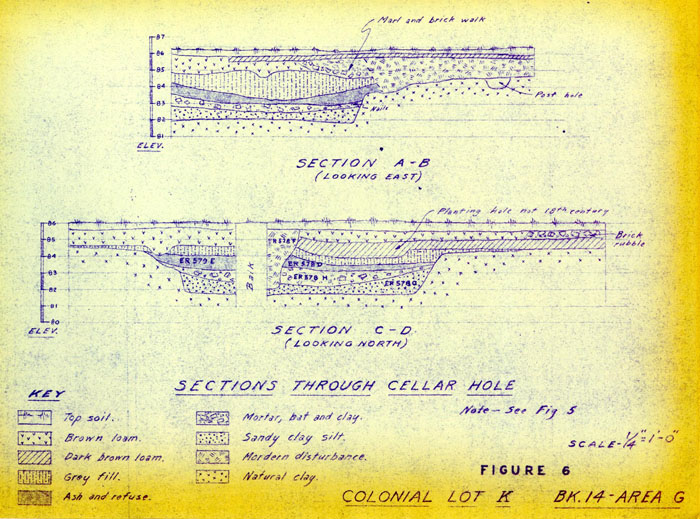 FIGURE 6 COLONIAL LOT K BK.14-AREA G
FIGURE 7 COLONIAL LOT K - NORTH OF FIG. 2 BK.14 - AREA G
Oversized Image
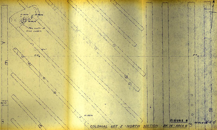 FIGURE 8 COLONIAL LOT J - NORTH SECTION - BK.14 - AREA G
FIGURE 9 COLONIAL LOT J - NORTHEAST AREA BK.14 - AREA G
Oversized Image
FIGURE 10 PLAN OF 1962 EXCAVATIONS BK.14 AREA 6
Oversized Image
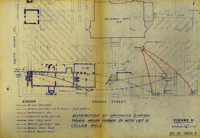 FIGURE 11 DISTRIBUTION OF ARTIFACTS LINKING TRAVIS HOUSE PERIOD IV WITH LOT K CELLAR HOLE.
FIGURE 12 COLONIAL LOT J & K BK.14 AREA G SHOWING COLONIAL FOUNDATION DESTROYED BEFORI 1782
Oversized Image
 Figure 13A. Travis House insurance plats
 Figure 13B. Travis House insurance plats
 Figure 13C. Travis House insurance plats
 Figure 13D. Travis House insurance plats