James Anderson House Archaeological Report, Block 10 Building 22 Lot 18Originally entitled: "Report on the 1975 Archaeological Excavations at the James Anderson House"
Colonial Williamsburg Foundation Library Research Report Series - 1227
Colonial Williamsburg Foundation Library
Williamsburg, Virginia
1990
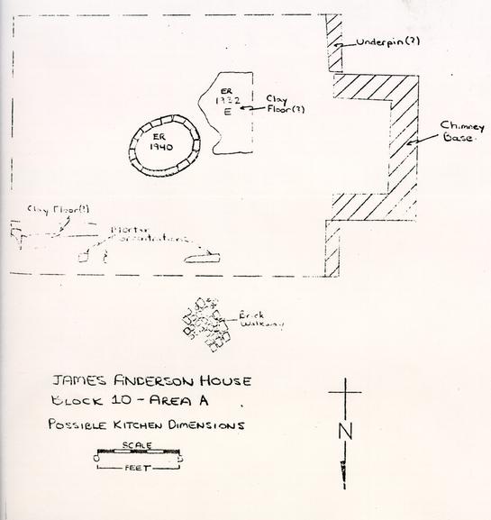 James Anderson - Possible Kitchen Dimensions
To: Mr. James R. Short
From: I. Noël Hume
Re: Transmittal of James Anderson Archaeological Report
I have pleasure in sending you herewith a copy of the above report which was prepared by contract archaeologist Robert Foss, with additional information provided by senior archaeologist, Eric Klingelhofer. The excellent drawings are the work of our draftsman, Ruth Anne Clarke.
I shall be grateful if you will pass this volume on to Roy Graham as he needs it to start work on the plans for the development of the Anderson complex.
I. N. H.
Copy to:
Mr. Roy Graham
RECEIVED
NOV 14 1977
ARCHITECTURE
To: Mr. James R. Short
From: I. Noël Hume
Re: Transmittal of James Anderson Archaeological Report
I have pleasure in sending you herewith a copy of the above report which was prepared by contract archaeologist Robert Foss, with additional information provided by senior archaeologist, Eric Klingelhofer. The excellent drawings are the work of our draftsman, Ruth Anne Clarke.
I shall be grateful if you will pass this volume on to Roy Graham as he needs it to start work on the plans for the development of the Anderson complex.
I. N. H.
Copy to:
Mr. Roy Graham
REPORT ON
THE 1975 ARCHAEOLOGICAL EXCAVATIONS
AT THE JAMES ANDERSON HOUSE
| List of Figures | |
| List of Plates | |
| Introduction | p. 1 |
| History | p. 5 |
| Archaeological Method | p. 15 |
| Archaeological Evidence | |
| 1931 Excavations | p. 17 |
| 1939 Excavations | p. 17 |
| 1941 Excavations | p. 18 |
| Preliminary Excavations 1974-75 | p. 18 |
| The Shops | p. 19 |
| James Anderson Period I | p. 19 |
| Shop A-1 | p. 19 |
| Forge A | p. 21 |
| Shop B | p. 23 |
| Forge B | p. 24 |
| James Anderson Period II | p. 25 |
| Shop A-2 | p. 25 |
| Forge C, | p. 26 |
| Forge D | p. 27 |
| Drain Slot | p. 29 |
| Shop B | p. 30 |
| Fence C and the Northern End of the Lot | p. 31 |
| James Anderson Period III | p. 32 |
| Shop A-3 | p. 32 |
| The North Wall | p. 33 |
| The West Wall | p. 33 |
| The Northwest Corner | p. 34 |
| Possible Northern Extension | p. 35 |
| Eastern Shop Wall | p. 35 |
| Forge E | p. 35 |
| Fence D | p. 37 |
| Relation of Shop A-3 to Kitchen | p. 37 |
| Shop C | p. 38 |
| Forge F | p. 39 |
| Forge G | p. 40 |
| Walk B | p. 40 |
| Clinker Spread | p. 40 |
| Post-1779 Features | p. 41 |
| Forge H | p. 41 |
| Forge J | p. 42 |
| Working Level in Shop A-2 | p. 42 |
| Bellows Support Holes (′) | p. 43 |
| Anvil Stands (′) | p. 44 |
| Possible Lean-to Addition to Shop C | p. 44 |
| Destruction Level | p. 44 |
| Beam Slot | p. 45 |
| The James Anderson House | p. 45 |
| Smokehouse | p. 48 |
| First Period Kitchen | p. 50 |
| Brick Drain Tunnel B | p. 52 |
| Related Walkway | p. 53 |
| Evidence of Kitchen Removed | p. 53 |
| Summary | p. 54 |
| Second Period Kitchen | p. 54 |
| Drainage System | p. 56 |
| Box Drain | p. 56 |
| Drain Tunnel A | p. 57 |
| Early Brick Drain (′) | p. 58 |
| Wells | p. 59 |
| Well A | p. 60 |
| Well B | p. 60 |
| Walks | p. 63 |
| Walk A | p. 63 |
| Walk B | p. 64 |
| Walk C | p. 65 |
| Walk D | p. 65 |
| Fence Lines | p. 66 |
| Western Property Line | p. 67 |
| Fence A | p. 67 |
| Fence B | p. 67 |
| Garden Fence | p. 69 |
| Later Fence Lines Along Western Property Line | p. 70 |
| Eastern Property Line | p. 70 |
| Fence C | p. 71 |
| Fence D | p. 71 |
| Fence E | p. 72 |
| Other Post Holes | p. 73 |
| Privies | |
| Privy A | p. 73 |
| Privy B | p. 74 |
| Privies C, D, and E | p. 75 |
| Fill | p. 76 |
| Southern Ravine Fill | p. 76 |
| Northern Ravine Fill | p. 78 |
| Yard Levels North of 1st Period Kitchen | p. 80 |
| Artifact Distribution | p. 82 |
| Cut Iron | p. 82 |
| Brass Working | p. 82 |
| Gunflints | p. 82 |
| Bone Discs | p. 83 |
| Problems with Distribution Analysis | p. 84 |
| Conclusions | p. 85 |
| Notes | p. 90 |
| Appendix I, Summary of excavation Register | p. 92 |
| Appendix II, The Human Skeletons | p. 101 |
| Appendix III, Description of Brick Samples | p. 113 |
| Appendix IV, Description of Mortar Samples | p. 117 |
| Appendix V, List of Post Hole in Figures 15 & 16 | p. 121 |
| Appendix VI, Faunal Analysis | p. 124 |
| Figure 1 -Detail of Frenchman's Map, Colonial Lots 18 and 19 | Following p. 10 |
| Figure 2 -Plan of James Anderson Shops, Period I | Front Envelope |
| Figure 3 -Plan of James Anderson Shops, Period II | " " |
| Figure 4 -Plan of James Anderson Shops, Period III | " " |
| Figure 5 -Southern Section of Forge E - North of Garage | Following p. 36 |
| Figure 6 -Plan and Section of Smokehouse | " p. 49 |
| Figure 7 -Plan of First Period Kitchen | Front Envelope |
| Figure 8 -Plan and Section of Box Drain | Following p. 56 |
| Figure 9 -Plan of Well A | " p. 62 |
| Figure 10 -Section of Well B" p. 63 | |
| Figure 11 -Section from Smokehouse through Forge E | Front Envelope |
| Figure 12 -Section of east side of E.R.1925 and E.R.1930 | " " |
| Figure 13 -Plan of Erosion Gullies | Following p. 81 |
| Figure 14 -Artifact Distribution Map | Front Envelope |
| Figure 15 -West Property Boundary Post Holes | " " |
| Figure 16 - East - West Post Holes | " " |
| Figure 17 -Overall Site Plan | Rear Envelope |
| Figure 18 - Skeleton in Grave E.R.1942L | Following p. 106 |
| Plate I | Detail of Forge A. |
| Plate II | Overhead view of Shop A-2. |
| Plate III | Robber trench for east wall of Shop A-2 and walkway B. |
| Plate IV | Robber trench for south wall of Shop A-2 and drainage ditch. |
| Plate V | Detail of "barrel stand" E.R.1973T-10.A. |
| Plate VI | Northern portion of Shop A-3. |
| Plate VII | Sectional view of Forge E and north wall of Shop A-3 |
| Plate VIII | Overhead view of southern shop complex. |
| Plate IX | Walkway B and post holes along east side of Shop C. |
| Plate X | Detail of Forge F and east wall of Shop B. |
| Plate XI | West end of lst period kitchen. |
| Plate XII | Overhead view of drain tunnel B and kitchen wall. |
| Plate XIII | Overhead view of drain tunnel B and kitchen wall, dismantled. |
| Plate XIV | Box drain west of James Anderson House. |
| Plate XV | Drain tunnel A and rubble fill of well A. |
| Plate XVI | Rubble filled shaft of well A. |
| Plate XVII | Well head and lining of well A. |
| Plate XVIII | Overhead view of secondary construction of well A. |
| Plate XIX | Well B. |
| Plate XX | Detail of walkway A. |
| Plate XXI | Fence lines A & B. |
| Plate XXII | Sectional view of northern balk of E.R.1921/27-10.A at completion. |
INTRODUCTION
In the fall of 1974, Colonial Williamsburg revived plans for the reconstruction of the blacksmith and gunsmith shops on the James Anderson site (Block 10) prompting a need for further archaeological work on the site. In the winter of the same year, this writer, under the auspices of the Department of Archaeology, began a short-termed salvage project centered on the area of proposed construction. Prior to this project, archaeological investigations had been conducted on the western side of the property in 1931. Upon acquiring the eastern side of the lot in 1939, the excavations were extended and the James Anderson House and four outbuildings reconstructed on the site. A kitchen was built to the east of the property on the site of one of two kitchen foundations excavated. In addition, to the west a smokehouse was rebuilt on the site of foundations found almost five feet below modern grade, a structure which the recent excavations show had ceased to exist before blacksmith, James Anderson acquired the lot. The most important structure (to this report), however, is the modern garage which was built over part of one of Anderson's workshops and named the Nancy Camp, Forge.*
The original goal of the 1974 project was to expose the 2. foundations within and to the north of the present garage in order to allow the architects a final re-examination. As the three-week project expanded to six, newly emerging information cast doubt on the validity of basing reconstruction plans on the findings of the earlier excavations. Of particular note was the discovery of a level of coal clinker, associated with Anderson's industrial activities, beneath the northern forge foundation. This revelation made it clear that the forge in question was not a part of Anderson's original shop, and was possibly not associated with the Revolutionary War. This, of course, raised a number of questions about the site's original interpretation. Indeed, if Colonial Williamsburg wished to portray the site as it was ca.1776-1782, it was evident that the re-excavation of the entire site would be needed.
Preliminary excavations revealed that a great deal of the site had been left virtually untouched by previous digging. All of the structural remains shown on the plan of the 1931 excavations were found to be intact (with the exception of those removed by the 1940 reconstruction), thus providing an opportunity to look again at structural details. And perhaps to obtain pertinent dating information from hitherto undisturbed soil layers sealed beneath the foundations.
Large scale re-excavation began in March 1975 and continued until March 1976, its primary goal to obtain as much information as possible concerning Anderson's occupancy of the property. This included such data as shop construction, arrangement, and chronology, as well as the overall appearance 3. of the site. Further, the recovery of artifacts offered an opportunity to learn more about the metal-working activities of Anderson and his men during and after the Revolutionary War.
The excavated area included all of the yard enclosed by a fence flanking the modern walkways around the garden, as well as the interior of the garage and the open ground to the south of it. Unfortunately, the 1931 excavations had almost completely destroyed any evidence for either construction or destruction dates for Anderson's shops. The five foot deep foundation walls of the modern garage (the Nancy Camp Forge) obliterated all evidence of the brick footings upon which the structure was based. This loss to present interpretive attempts was disastrous, as will be seen later in this report. In fact, with this all-destroying swath cut across the midsection of Anderson's shops, it proved impossible to obtain the necessary information to establish a reliable chronology for the structures.
On the credit side, however, the remains of three shops were identified, representing at least three distinct periods of construction and containing the remains of nine forges of various dates. The shops were located along the western side of the lot, and probably were of frame construction resting upon brick footings, parts of which remained intact while other sections had been robbed. Although no date for the construction of Anderson's first shop was forthcoming, it seems probable that he began his activity on the lot sometime prior to 1777.
4.Secondary in goal, but not in importance to our understanding of the site, was the excavation of fill and the location of structures pre-dating Anderson's ownership of the lot. The amount of stratified fill revealed during the winter of 1974 indicated that large areas remained untouched and would provide fertile ground for obtaining information on the site's development.
Archaeological information, viewed in correlation with the historical data available, revealed that Lot 18 had seen little use prior to ca.1755-60. In fact, aside from the story-and-a-half shop to the east of the two-story Anderson House (which was not investigated during this project), there is scant evidence for any significant structures on the site before that date. Sufficient information was amassed, however, to conclude that a kitchen had been constructed in the yard ca.1760 and had probably functioned throughout Anderson's occupation. Other pre-Anderson features consisted mainly of fence lines, privies, and an early smokehouse.
The following report presents a summary of the history of Lot 18 and an analysis of the mass of archaeological evidence retrieved. It should be borne in mind, however, that these excavations did not exhaustively cover the entire site, and that for this and other reasons many gaps remain in our understanding of the physical and temporal development of the property.
HISTORY
The history of Lot 18 is far from complete. Located on the eastern side of a ravine which, prior to ca.1723, cut a swath across Duke of Gloucester Street,1 there can be little doubt that topography played an important role in the use and development of the property. Being relatively rugged land, it seems likely that its development would have been delayed until the more desirable lots had been settled.
The first known owner of Lot 18 was Thomas Ravenscroft. A lease deed dated November 1723 conveyed to Cole Diggs:
... ye plot or draught thereof by ye Numbers or Figures 17 & 18 together with all the houses outhouses Edifices gardens orchards woods wells waters & water courses and all other advantages priveliges and appurtenances thereunto belonging.2
Apparently this deed was in error, as Mary Stephenson has discovered that at that time, Lot 17 was owned by John James Flournoy, not Ravenscroft.3 As later deeds indicate that Diggs held Lots 18 and 19, it seems likely that Ravenscroft in fact owned these two lots rather than Lot 17. This is important to our understanding of the early history of Lot 18 because while only about half of it lay in the natural draw, the entirety of Lot 17 was in the ravine. It is known that in order for Ravenscroft to have held the property he had to construct a building suitable for a dwelling4 and of course, he must have done so. Because he owned both Lots 18 and 19, however, we have no way of knowing upon which lot he built. It seems most reasonable to assume that he would have chosen the more level of the two; that is the one located on the 6. corner, Lot 19.
Between 1723 and 1755 there is virtually no mention of the property, though apparently Cole Diggs did convey it to his son, Dudley, sometime prior to 1755.5 In that year, the younger Diggs leased a portion of the property to barber and perukemaker, James Currie.6 It seems that one Doctor McKenzie had previously built a shop on this property; and, upon his death, Diggs leased it to Currie.7 Archaeological investigations in 1939 revealed the walled cellar of a building facing Duke of Gloucester Street on the eastern side of Lot 18. It was concluded then that the foundations must have represented the remains of the shop mentioned in the 1755 lease.8 As present excavations did not encroach upon this area of the site, that supposition can be neither proved nor disproved, though it does seem a reasonable inference. Even as late as 1755, the eastern side of Lot 18 was the more desirable location.
Between 1755 and 1760, Dudley Diggs transferred both Lots 18 and 19 to William Withers. What use Withers made of them is not known, though it may be assumed that Currie continued to occupy his shop on Lot 18. In 1760. Withers split the two lots, selling Lot 19 to William Carter and Lot 18 (plus a 5'6" strip of Lot 19) to William Holt. Holt's deed included " ... all buildings gardens ways..." and, most importantly, indicated that lodging house and tavern keeper Christiana Campbell had the tenure and occupation.9 Thus we learn that prior to November of 1760 Mrs. Campbell had moved to Lot 18, presumably to operate a tavern. Was there a 7. building constructed west of Currie's shop between 1755 and 1760, or was Mrs. Campbell occupying a portion of the structure to the east′ From the historical record we learn only that a building existed to the west by 1769. Prior to that it can only be conjectured based upon inferences concerning the "quality" of an establishment run by Mrs. Campbell. The archaeological evidence, however, points to definite activity on the western side of the property between 1755 and 1760.
The historical evidence reveals that Chandler Freer Armston advertised in 1769 that he had opened a shop "...between Mr. Carter's great brick house and Mrs. Rathell's...".10 Mrs. Rathell was a milliner who was apparently located on Lot 18 during 1769. It can be deduced from the wording of Armston's advertisement that his shop was located in the small building to the east while Mrs. Rathell was situated in the larger building to the west, perhaps the same as the one used by Christiana Campbell.
In October 1770 Holt sold Lot 18 in its entirety, along with the 5'6" strip of Lot 19, to James Anderson, blacksmith,11 at which date the deed indicated a major change in the value of the property. Holt had paid only £350 for it in 1760, but sold it to Anderson ten years later for £600. Although this could have been due to an enormous rate of inflation, it is more likely to have been the result of improvements made on the lot during Holt's ownership.
Anderson, who had been acting as public armourer for Williamsburg since ca.1766,12 already owned the southern half of Lot 19, having purchased it from William Carter in 1767.13 8. Anderson did not immediately move on to Lot 18 because we find, in 1771, that William Drinkard had opened a tavern "...in the house lately occupied by Mr. William Holt...", presumably a structure located on the western side of Lot 18.14 Exactly how long Drinkard was on the site is not known from the historical record, and it cannot be determined whether Anderson made any use of the southern end of the lot while Drinkard was there. Archaeological evidence, derived from both the 1931 and 1975 excavations, makes it clear, however, that Anderson did have shops along the western property lines, some of which may have dated to the early 1770s.
Anderson was a blacksmith of note, and as mentioned previously, was acting as public armourer prior to his purchase of Lot 18. It seems likely, therefore, that he would have had a shop located on Lot 19. In fact, archaeological investigations on that property in 1941 did uncover the remains of two brick forges enclosed by a small structure. In association with these features, a quantity of rusted iron and cinder was found, thus substantiating the theory that Anderson had at least one workshop on that lot.15
In March 1776 Anderson was appointed public armourer for Virginia's Revolutionary forces.16 We learn in a letter from Patrick Henry to Richard Henry Lee that, in March of 1777, Anderson had two forges, six sets of tools, eight vises, and five apprentices.17 There is a valid question raised about the date of this letter, however, as it seems to relate to March of 1776 rather than to March of 1777. The archaeological information mentioned above indicates that Anderson had two forges on Lot 19, and it is possible that it was these to which 9. Patrick Henry referred. If such were the case (and unfortunately there is little evidence either for or against such a hypothesis), then it would appear that Anderson could not have been working on Lot 18 prior to Henry's letter of 1777 [or 1776]. It is entirely possible, of course, that Anderson may have had more than two forges but was using those mentioned by Henry solely for work done for the Commonwealth. Certainly throughout the years of the war Anderson continued his private trade with the community, and this could very easily have necessitated a separate shop.18
Surviving manuscript ledgers of carpenter and brickmason Humphrey Harwood contain frequent references to work done for Anderson. In January 1777, Harwood built a forge chimney and underpinned the shop.19 In comparing the cost of this forge with those built later we find an interesting discrepancy which may be of some importance. In 1777 Harwood charged 30 shillings for building a forge chimney, but two years later he only charged 16 shillings for a similar job. It seems possible, therefore, that rather than having construct one forge chimney in 1777, he, in fact, built two. [not valid - 16 shill could have been to (re) build a forge.]
In February 1779, Harwood built three forge chimneys and underpinned the shop.20 In April Anderson advertised for a blacksmith and nailer capable of serving as a shop foreman, and six "negro fellows."21 In June of the same year, he advertised for gunstockers and blacksmiths.22 Obviously, Anderson's need for a shop foreman suggested that his business was rapidly expanding, and perhaps that a separation of his shops prevented him from supervising the work himself. It 10. seems that by 1779 Anderson had at least two shops; one with two forges and another with three [3 forges in one shop′] both probably located on the west side of Lot 18. Soon after this construction, in 1780, Anderson moved with the rest of the government to the greater safety of Richmond, and there continued to act as armourer for the Commonwealth until he retired and returned to Williamsburg in 1782.23
The only visual evidence for the arrangement of Anderson's shops is found on the Frenchman's Map of Williamsburg, drawn ca.1782 while French troops were quartered in the town, and we can safely assume that it shows the structures on Anderson's property as they were when he left for Richmond. (Figure 1) On this map two long structures are shown abutting the western property line, but helpful though this is, the drawing poses two troublesome problems. The first is the offset shown between the two contiguous structures, and the second, the proximity of the shops to the main dwelling. The archaeological evidence now shows that the "Frenchman" had shifted the shops too far to the north, and had made them too long. The map also locates several ancillary buildings, two to the south which may be part of Anderson's workshop complex, and one to the east of the northern shop building, which is probably the first period kitchen.
The end of the Revolutionary War did not bring an end to Anderson's apparent prosperity. After his return from Richmond, he continued his private trade as blacksmith. Between 1785 and 1789, Humphrey Harwood's ledgers contained several references to building forges for Anderson. In November 1786
 FIG. 1 - DETAIL OF THE "FRENCHMAN'S MAP," COLONIAL LOTS 18 AND 19
11.
he built two forges,24 three during 1788,25 and two more in 1789.26 In all probability these were repairs to already existing forges located on Lot 18.
FIG. 1 - DETAIL OF THE "FRENCHMAN'S MAP," COLONIAL LOTS 18 AND 19
11.
he built two forges,24 three during 1788,25 and two more in 1789.26 In all probability these were repairs to already existing forges located on Lot 18.
After Anderson's death in 1798, his real estate was divided among his eight children, Lot 18 being acquired by his daughter, Nancy Camp.27 She was apparently living on the site in 1805 and by 1806 had purchased the property from the estate. The purchase of lumber for sills and planking and a large quantity of nails that summer suggests that Nancy Camp was undertaking repair work or construction on Lot 18.28 An insurance policy dated 1810 places a kitchen along the eastern side of the lot.29 As there is no prior indication of there having been a structure in that location, it is likely that in 1806 Nancy Camp relocated the old colonial kitchen.
Throughout the early 1800s, the account books of Robert Anderson (son of James Anderson) contain entries made both for materials purchased and for work done at Nancy Camp 's "White House." Thus, in July 1812, there are references to work on a well, including the purchase of bricks; and also "Merchandise for pales and posts."30 The work on the well could be a reference to the well shaft located west of the 1806 kitchen, which archaeology has determined to have been worked on sometime early in the nineteenth century. The pales and posts could have been used anywhere on the site, but probably relate to a fence line found running across the site to the south of the second period kitchen.
In 1823 Nancy Camp moved to Norfolk leaving the house occupied by her brother, Robert. A succession of insurance 12. policies were drawn up during his occupancy, each mentioning the large dwelling house and its east wing as well as the kitchen.31 None makes any note of the forge shops along the west; so it is reasonable to assume that they had been removed or were in such disrepair that there was no need to insure them. Finally, in 1842, the house and surrounding outbuildings were consumed in a fire which swept through the entire block.
In addition to the preceding information on the evolution of the use of Lot 18, the historical record contains a variety of information to help define the kinds of services provided by Anderson. Two of his ledgers (1778-1785; 1789-1799) show that by far the most common was the shoeing of horses, though he was also employed to mend and manufacture a variety of tools, and to repair harness gear and ironwork for carriages and wagons. The work on these vehicles points to a need for at least one of the shops to have been open on one or more sides so that the wagons or carriages could be worked on close by the forge.
Although the ledgers deal mainly with the day to day trade of local residents, we also see that he had accounts with several institutions. For close on two years (1789-1791) there were entries nearly every other day for work done for the "Stage." This consisted almost entirely of the shoeing of horses and repairing various parts of the coaches, however little is known of the stage line. Other accounts were with the Public Jail, the Capitol, and the Public Hospital, none of them sizable, and limited mainly to the making and repairing of locks and putting irons on men.
13.Because James Anderson's work during the American Revolution made him the center of the military "presence" throughout the war years, the main account of interest to this project was with "the Continent," but unfortunately his ledgers contain little information on this aspect of his work and is limited to the same sorts of work done for the rest of the community, i.e., shoeing horses, repairing wagons, etc. The reason for this lack of information could be that because Anderson was being paid approximately £50 per month as public armourer,32 there was little need to itemize the work in the account books. Aside from the typical blacksmith's work necessary to keep the army equipped, it is known that on several occasions he inspected, cleaned, and repaired the arms in the public magazine, It is not known whether this work was done on Lot 18, for in 1779 the Commonwealth paid Mrs. Hay nine months' rent for a house in which prisoners were employed to repair and clean arms.33 However, excavations at the site of the Anthony Hay Cabinetshop revealed considerable evidence of the repairing of muskets.
The historical records tell little that could not be deduced from knowing of Anderson's position as public armourer and his role of blacksmith in eighteenth-century Williamsburg. Certainly his work was varied, i.e., he was not limited to a small number of products but was capable of taking on almost any job involving the reshaping of iron. We also learn that (at least during the war years) his shops were busy and he had need to employ many hands, both skilled craftsmen and mere laborers.
14.From the scant documentary material available on the history of Lot 18 we are able to see a shadowy outline of the changes that occurred. Limited activity on the site prior to ca.1760 was followed by a surge of construction resulting in the basic differences noted in the appearance of the lot. With Anderson's arrival and the outbreak of the Revolutionary War, changes occurred in rapid succession — in fact, so fast that it is difficult to interpret exactly what was going on or where it was happening. Shops were erected; shops fell into disrepair, and shops were replaced. Because the historical documentation does not fully define the nature and location of the changes, it is left to archaeology to try to answer those questions.
ARCHAEOLOGICAL METHOD
In general, the site was excavated following the standard practice of the Department of Archaeology. Prior to excavation an arbitrary grid was imposed upon the site in order to delineate manageable horizontal areas for removal. Ideally, these units were ten foot squares separated by standing balks for the recording of the vertical stratigraphy. Vertically, the soil was removed according to the natural levels discernible. There were, however, areas where the fill was not well defined into different levels. In these areas arbitrary levels of three inches were employed in order to attain some positive control over the fill's temporal deposition.
Spatial limitations were imposed upon the site both by the location of standing structures and the temporary fence constructed around the yard in order to allow visitors to view the progress of the excavations. Because of these barriers, the excavated areas did not always adhere to the ideal ten foot squares with balks. Indeed, variations in this method were made in the field whenever it was thought advantageous in revealing important information, though the record keeping identifies these changes in relationship to the standard grid.
The prime factor at the outset of the excavation was the delineation and removal of modern backfill from a number of Colonial Williamsburg archaeological and utility trenches. Because the 1931 excavations were primarily oriented towards the location of brick structures, the technique used was to dig trenches until a wall was located, and then to trace the 16. wall. No record was made of the location of those trenches, so it became a major task for the 1975 excavators to first locate and then remove the fill from these older "modern" disturbances. The entire site, particularly to the north of the garage, was found to be riddled with these cuts, often made down wall lines where no brick was found in place. In some areas, notably that of Anderson's shops, all of the overlying fill was stripped, thus destroying virtually all evidence of working surfaces or post- destruction debris.
The location of a 150-175 year old Elm tree presented another obstacle to complete excavation, for being considered a tree of high value to the portrayal of the site, its root system was to be preserved at all costs.
ARCHAEOLOGICAL EVIDENCE
1931 EXCAVATIONS
Only very limited information was obtained from the excavations conducted on the western side of the lot during 1931. A plan of the located foundations and a few photographs gave some idea of what was to be expected, and were useful in determining priorities for the 1975 project. From the plan, however, no idea of temporal relations between the structures could be determined, though it did contain a key for relative dating based upon brick size and mortar type.. Most of the foundations had been left as they were found, but in one instance a modern garage had been constructed upon a one Brick (81/2") wide-wall located along the western property line. Unfortunately, as previously noted, the loss of those building remains presented a major obstacle in determining the correct chronology for Anderson's shops.
1939 EXCAVATIONS
After Colonial Williamsburg had acquired the Moseley Lot (which represented the east side of colonial Lot 18), excavations were undertaken there in 1939. Both a plan of the excavations and a short written report on the findings remain for use by present and future researchers. The most important discoveries were the location of a 20'00" by 30'00" structure fronting a 20'00" by 16'00" kitchen foundation on the eastern property line. The kitchen had been constructed over a backfilled well shaft of undetermined date. Because these 18. foundations were interpreted in 1939 as belonging to a kitchen in existence on the site during James Anderson's occupancy, the present reconstructed kitchen was built on this location. Colonial Williamsburg architects also concluded that the structure facing the main street had been a later addition to the large building located during the 1931 excavations, and that it had been built as a shop.
1941 EXCAVATIONS
Excavations were conducted south of the present east-west fence line dividing the lot. Although the current excavations merely tested this area of the site (Area 10-G), a plan of the earlier excavations indicated the presence of a possible structure on the western side of the lot which could have been one of those shown on the Frenchman's Map. The brick remains of what later proved to be another of Anderson's forges was partially uncovered, but not identified.
PRELIMINARY EXCAVATIONS 1974-75
In December of 1974, planning for the reconstruction of the James Anderson blacksmith shop moved forward and the Department of Archaeology undertook a salvage project with the aim of relocating the structural features uncovered in 1931 and removing any stratified fill which would be destroyed by the impending construction work. The original goal of the project was short-termed, hoping only to re-evaluate the architectural information obtained in the earlier excavations. However, the evidence recovered (see "Preliminary Report on Archaeological Excavations at the James Anderson House") necessitated the larger scaled excavations herein reported.
THE SHOPS
As noted earlier in this report, it was believed that Anderson located his shops along the western side of the lot. The Frenchman's Map shows two large structures with two smaller ones to the south along this property line (Figure 1). In addition, the 1931 excavations revealed the remains of two, or possibly three, brick boxes which were probably among Anderson's forges. It is known that Humphrey Harwood built as many as ten forges for Anderson between 1777 and 1798. There is no way of determining how many of these forges Anderson had in operation at any one time, although present excavations have revealed the remains of eight forges, including two of those found in 1931.
JAMES ANDERSON PERIOD I
There is no evidence that when Anderson purchased Lot 18 in 1770 there were any structures along the western side of the property (Figure 2). Shortly after his arrival, however, it appears from the archaeological record that he constructed two buildings along the property line, perhaps associated with two external forges.
Shop A-1
Without any reliable archaeological or historical data to locate or identify the early shops that Anderson operated on the property, much of what follows is necessarily based upon conjecture and cannot be construed as an absolute interpretation. The plan of the 1931 excavation raises many 20. questions which, due to the construction of the modern garage, can never be satisfactorily answered. On the site of the reconstructed building, the plan shows several features which have since been destroyed. Most notable are two sections of brick wall, one along the western property line and the other at a right angle to its southern end. At the location of the present northern wall of the garage were two brick features, one an elongated rectangular box and, to its south, two brick projections. According to the chronological key provided with the plan, all of these features are of the same period, of construction. Although many inaccuracies have been discovered on this archaeological plan, it would be presumptuous to assume, merely because the data given does not conform to conjectural ideas, that this interpretation of the chronology was also in error.
There is a discrepancy, however, in the information. It is assumed that relative dating for the structures located in 1931 was mainly on the basis of brick size and color and mortar type. If this is so, there is no apparent reason for the conclusion that the walls and brick box are of the same period. The sizes of the brick used in these two features are quite different (walls: 8½" x 3¾" x 3 ½"; [2 ½ per brick schedule 1932] box: 8¼" x 4" x 2 ¾"), possibly reflecting bricks of two different periods. Although brick size is by no means the most satisfactory method of dating a structure, it is, alas, the only data available. But because it makes little or no sense for these two features to be contemporary, we can reasonably consider the possibility that they were not.
21.This then leaves something of a problem. There is neither historical nor archaeological data to indicate when Anderson arrived on the property or what structures were there at that time. In light of information to be presented later, it seems likely that the walls shown on the 1931 plan may, indeed, represent a building either constructed by Anderson shortly after his arrival on the site or one which was already there. The western wall was one brick thick, as was that at the south. There is no way of determining the building's north-south length, though its east-west dimension must have been approximately 20'00" wide, based upon the location of later Walkway "B".
The thickness of the walls would indicate a frame building of one or one and a half stories. Two post holes located to the south of the structure (ER 1972B and ER 1973W) seem to be temporally related with Shop "A-1" and may have supported a stair entrance to an upper level storage or living loft. It also appears from the 1931 plan that this building was not well constructed as the southern wall is not actually straight but rather bends slightly to the north.
As cautioned above, the preceding must be taken as the most likely interpretation of the scant data available. It is hoped, however, that the succeeding pages (which are based upon more substantial information) will lend a greater degree of credibility to this conjectural first shop.
Forge A
Located to the north of Shop "A-1" and to the west of the First Period Kitchen (see p.50) was found the fragmentary 22. remains of a brick box. This feature was uncovered during both the 1931 and 1974 excavations but it was not until the removal of Forge "E"(see p.35) that it was properly identified as an earlier forge.
Although the foundation of Forge "A" was not complete, its size and shape could be estimated with reasonable accuracy. External dimensions seem to have measured 6'1" by 6'00"; the north, south and west sides were probably 1½ brick courses wide while the eastern side was a full 2½ courses in width and no doubt supported the weight of a chimney. There is, however, no evidence of a structure over this forge; thus, it is most likely that it was external and free standing.
An interesting yet difficult to interpret feature was located in the north side of Forge "A's" foundation. A small hole (approximately 2½" in diameter and 11" deep) had been drilled through the outside course of the bricks (ER 1963H), into which a sheet-iron sheathed wooden post had been set. There can be no doubt that this post was associated with the forge for its socket was sealed by the same ash deposit that covered the rest of the forge well (ER 1963G). Two explanations for the post's presence have been suggested, neither of them fully satisfactory. It may have been an added support for holding large heavy items over the fire (though its small diameter does not suggest the strength necessary for such a task) or it may have had some relation to a bellows, the mechanics of whose arrangement is not clear. As none of the other forges exhibited such a feature, one may deduce that its function was peculiar to whatever work was performed at this forge.
23.Around the Forge "A" foundation discovered beneath Forge "E", a spread of coal dust and ash (ER 19631) is believed to represent the working level for the forge. If so, the presence of the ash on the west side of the structure provides evidence to suggest that this forge was operated from the west. Although a construction terminus post quem of post-1745 was obtained, no artifacts recovered from this area were helpful in either dating the forge's use or identifying the work done there.
Shop B
Located approximately 25'00" south of Shop "A-1" was found the remains of another small structure which was probably associated with the early days of Anderson's occupation. Although all but the southern wall had been robbed, the lines of the walls were delineated by the location of rubble-filled "robber's" trenches (ER 1969J, ER 1970C, and ER 1975Z). The southern wall was represented by a one course wide foundation and was constructed above a level of gray loam (ER 1970Z) and an earlier backfilled privy pit (ER 1981K). Although instability of this underlying fill caused part of the foundation to settle, there was no evidence of any attempt to repair the damage.
The building itself was found to measure 12'3" by 10'00" with an east-west orientation. Located close to the center of the floor was a post hole (ER 1981C) which was definitely associated with the use of the structure (it, too, cut through the gray sandy loam). It has been suggested that the post supported a storage loft or perhaps a pyramidal-shaped roof. Outside the eastern wall of the shop was found evidence for 24. the location of a doorway. Two small post holes (ER 1975X and ER 1975W) flanked three bricks, and located as they were at the center of the eastern wall, they may represent the location of a stoop entrance.
The gray sandy loam level upon which the building was constructed contained fragments of creamware (post ca.1769), thus helping to substantiate the theory that Anderson constructed this building after his arrival on the site. Further support for that hypothesis is found in the similarity of Shops "A-1" and "B" to two structures excavated in the rear of Lot 19.34 As mentioned earlier, Anderson already owned Lot 19, and it is possible that he moved both structures when he acquired the new property.
Forge B
Located 6'3" to the south of Shop "B", the fragmentary remains of yet another of Anderson's early forges were found. The southeast corner of this one course wide brick box was cut through by later Forge "G" (see p.40). Although only the northern and eastern walls of the structure were extant, the remains were 9" by 4'10". The forge itself was laid upon a level of gray sandy loam (ER 1971S) which represented the backyard fill from the pre-Anderson period of occupation, and was equivalent to the layer upon which Shop "B" was constructed.
Directly to the west of Forge "B", a depression (probably a natural gully) had been utilized as a dump for clinker and iron waste (ER 1971J). The close proximity of this pit to the forge, and the lack of indication of an associated structure, would tend to indicate that, as with Forge "A", this fire 25. box was also externally operated.
JAMES ANDERSON PERIOD II
Although the succeeding years brought rapid developments in Anderson's shop arrangement, a correlation of the historical data and the archaeological information helps to establish the chronology of the construction (see figure 3). From Humphrey Harwood's ledger we found that in 1777 he was engaged by Anderson to build a forge chimney and underpin the shop; and, as argued on page 9, it seems most logical that he in fact built not one but two forges. [No! incorrect data] This conclusion corresponds well with the archaeological information which indicates that the next period of construction comprised the addition of a shop to the south of Shop "A-1" and the construction of two forges.
Shop A-2
The dimensions of this southern extension were 24'00" by 20'2" with a north-south orientation. Much of the western wall was extant and was 13" wide (1½ brick courses) and laid in English bond. Unfortunately, the northern end of this wall, where it intersected with the southwest corner of Shop "A-1", had been destroyed by the construction of the modern garage. The southern wall had been entirely stripped of its brick, but the level of the base of the robber's trench (ER 1974B and ER 1975B) indicated that the western wall had been sunk into the grayish loam level in order to establish a firm base on the downhill side of the ravine. The southern wall had then been stepped up to the ground level. Like this southern wall, the eastern foundation had also been robbed — with the exception 26. of one brick located directly in the southeast corner of the building (ER 1973N).
As noted above, evidence for the connection between Shops "A-1" and "A-2" had been totally destroyed by the construction of the modern garage. Because of the length of the total shop (i.e., structures "A-1 and "A-2), it seems most probable that the southern brick wall for Shop "A-1" would have been utilized when the addition was built. It is possible, for example, that the wall was dismantled to ground level, leaving a brick sill on which vertical studs could be placed to help support the weight of the structure's roof. Alternatively, the wall may have been left as a partition wall between the two shops. However, the former possibility seems the more plausible when considering the lineal arrangement of the forges within the shops which points to a strong likelihood that there was a visual line-of-sight throughout the combined workshops.
Forge C
The remains of Forge "C" were first discovered during the 1931 excavations and were re-exposed during preliminary investigations on the site in December 1974. Located within the confines of the modern garage, the forge measured 6'2" by 4'4" and survived to a maximum height of four courses. The north, south, and east sides were one and one-half courses wide while the west side was a full two courses in width, again suggesting that this side supported some sort of chimney or hood.
Though no working surface could be identified around this forge (having perhaps been removed by the previous excavations), 27. two circular pits were found in association with it. They lay both to north and south; measured 3'6" in diameter, cut 9" into the subsoil, and are believed to have been used to seat barrels of water used in quenching the hot iron. The mixed fill in these pits contained many chunks of rusted iron which, upon cleaning, proved to be unfinished waste material from the forge.
The southernmost of these pits (ER 1916B) had been cut through by the builder's trench for the modern garage. On the 1931 archaeological plan, however, the southern wall for Shop "A-1" shows a small bite out of the north face of the brickwork which may have been caused by digging the pit for Forge "C". If this is the correct interpretation, it helps to substantiate the hypothesis that when Shop "A-2" was added, the southern wall of Shop "A-1" was at least partially dismantled.
Forge D
The robbed remains of Forge "D" were first discovered during the preliminary excavations in the winter of 1974-75. Three levels of destruction fill were identified within the confines of the 6'4" by 4'9" feature and these aid in presenting a vivid picture of its dismantling. At the top was found a scatter of brick and mortar fragments (ER 1918D); and beneath it a level of coal clinker (ER 1918E) covered the entire feature. The fact that this clinker overlay the robbed walls of the forge itself is evidence that the clinker did not originate from the use of Forge "D" and was waste from another 28. forge in use after its destruction [or saved from its former use.] Below the clinker level was a layer of mortar and brick rubble contained within the rectangular wall lines of the robbed forge (ER 1918H). The robber's trench formed by the salvaging of the foundation bricks suggested that the walls had measured one and a half courses in width on the north, east, and south sides where two bricks survived, and gave some indication that the west side was two courses wide, though the evidence on that side was fragmentary. The bottom of the area originally enclosed by the walls of the forge was covered with mortar fragments (ER 1918J) which probably came from the dismantling of the structure. The forge measured 6'00" by 4'10" and stood onto the same line as others located on the site.
As with Forge "C", two large round pits were found in association with Forge "D." Unlike the former, however, these were not uniform either in depth or diameter. The hole to the southern side of the forge (ER 1918G) was excavated in 1974 and found to be 3'6" in diameter, and 2'00" deep, and contained iron waste material along with creamware sherds dating the fill after ca.1770. [is there terminal date′] The north hole measured 3'1" in diameter and was 10: in depth (ER 1973S). [′ 1973 T′ 1973 V′]
With the removal of the upper level of this feature, an ash-filled circular hole 1'2" in diameter was revealed within the larger hole. It appears that this small hole represented the actual diameter of the barrel (or tree stump′) which had been seated within the large hole around it.
As with the two pits associated with Forge "C," both of these are also assumed to have been the seatings for either water barrels or tree stumps upon which the anvil would be 29. placed. The presence of comparable features adjacent to these forges suggests that both forges belong to the same construction period — perhaps the 1777 construction billed by Humphrey Harwood.
Drain Slot
Close to the southern end of Shop "A-2", a trench 1'3" in width at the top was discovered which had apparently been added during the Period II usage in order to drain standing water from the eastern side of the building (Plate IV). The fill in this trench was stratified; the top 5" consisting of mottled clay and loam (ER 1975V). This fill was beneath (thus pre-dating) the ash floor level from the Period III usage (see p.42). Below the clay fill the trench narrowed to 1'1" in width and contained another 5" of gray-loam (ER 1975Y).
The trench ran the entire width of the shop and extended to the east of it to form an "L"-shaped catchment. It appeared that wooden planks had been laid across the bottom 5" of trough and were covered with the clay fill in order to get it back up to the shop's floor level. These planks probably rested on iron bars which spanned the lower 5" of the trench. One of these bars was found in situ while notches in the vertical sides of the trench marked the presumed location of two others. The surviving bar proved to be an interesting artifact in its own right (ER 1975). Measuring 1'9½" in length, the bar's ends showed that a blacksmith (perhaps an apprentice learning some of the basic skills) had worked it. One end was merely bent over on itself, but the other was turned at two right angles forming a "U" shape. Also at this end, a wedge-shaped 30. piece of iron had been attached — its purpose as yet undefined.
It would appear that the bottom 5" of the trench was left open to drain water through to the west side of the building. A concentration of iron artifacts within the trench to the eastern side of the structure, and the lack of finds at its western end, support such an interpretation as the entrance to the drain would be likely to accumulate heavier waste while the "downstream" end would only receive those artifacts which could be carried by the water run-off.
Along with iron waste, the artifacts recovered from the eastern end of the trench included a broken French wine bottle and part of a lead-glazed French earthenware chamberpot (ER 1975Y) This preponderance of French artifacts suggests that the filling of the drain took place ca.1781 while French troops were quartered in Williamsburg.
Shop B
During this second period of Anderson's activities the small southern outbuilding, Shop "B" (see p.23) continued to be used, but it appears from the character of the artifacts found in association with it that its use had become somewhat more specialized. Directly to the east of the structure and spreading over a surviving area measuring 7'5" by 4'6" was found an accumulation of discarded iron waste (ER 1975C). This dump was unlike any other concentration of waste found on the site, containing as it did a wide variety of objects, many seemingly related to wagons or carriages but also including two incomplete cutlass hilt guards. It is probable that this waste was derived from the main workshop (Shops "A-1" and "A-2") 31. rather than from Shop "B" which had no forge associated with it.
Analysis of the distribution of artifacts across the site indicates that two different operations had been performed in an adjacent southern outbuilding. Evidence of the first was provided by the preponderance of bone discs and the larger bones from which they had been cut which were found almost exclusively in the area to the east of the small shop. Because these discs are not found in the fill within Shop "A-2," it may be deduced that when the disc production began, that shop was already in existence. The discs themselves vary in size, but were made with a simple carpenter's bit which cut the desired sized hole into the bone, and in the process drilled a single hole in its center. It is believed that these discs were covered with cloth and used as buttons, and may have been associated with the maintenance of military uniforms. [See Anthony Artifact Rep]
The second activity apparently related to the storage and cleaning of weapons. Although gunflints were found in various areas of the site, the greatest number was found in the area associated with the small outbuilding. Again, the association can be made with the Period II occupation, placing this weapon work on Lot 18 between 1777 and 1779, when we know from the historical records that Anderson began to use the widow Hay's old cabinetshop for servicing the public arms.
Fence C and the Northern End of the Lot
With the construction of the southern extension of the main workshop (Shop "A-2") and the addition of Forges "C" and "D", Anderson apparently abandoned and dismantled his use of Forge "A" to the north of Shop "A-l." Whether he already 32. had moved into the main dwelling on Duke of Gloucester Street is not known, but it is clear that with the Period II construction, an attempt was made to separate the industrial activities of the southern end of the lot from the domestic activities at the north. This is most clearly seen by the erection of Fence "C" (see p.71) which ran east-west across the site flanking the south wall of the first period kitchen.
With this separation of activities, the area around and above Forge "A" was used as a repository for domestic trash, and later for the dumping of coal clinker from the southern forges. As shown in Figure 5, the vertical distance between Forge "A" and Forge "E" (see p.35) represents a time break between the destruction of the early forge and the construction of the Period III forge.
JAMES ANDERSON PERIOD III
From the historical record we know that in 1779 Anderson engaged Humphrey Harwood to build or rebuild three forges and underpin a shop. This represented the period III construction on the site and saw the shops at their final degree of expansion. (Figure 4)
Shop A-3
This structure was excavated in 1931 and again during preliminary exploration mounted during the winter of 1974 (see Figure 4). It consists of two brick foundation walls on the northern and western sides enclosing a brick forge. Since the 1931 excavations a steam line was installed between the James Anderson House and the reconstructed Mary Stith Tin Shop, located on the lot to the west. This utility line was cut through the forge foundation (and all the fill beneath it) 33. and destroyed a critical portion of the shop's western wall. Other modern disturbances were extensive south of the forge and obliterated any evidence of a working surface or related features for this shop.
The North Wall
Directly north of the forge foundation, a brick wall one course in width was discovered. The foundation was not continuous, but had been cut through by the modern steam line and unidentified disturbance west of the forge. [(exploration trenches 1931) See Photo #N2506] The wall was constructed of soft-fired, orangish-red brick mortared with oystershell mortar in English bond. The upper surviving course was laid in rowlock and may have been the level upon which the shop sill rested. An attempt had been made by the mason to base the wall on a firm footing for it extended 10" below the bottom of the forge. Though earlier Colonial Williamsburg trenching had destroyed any evidence of a builder's trench outside the wall, a narrow trench was found beneath the forge (ER 1963D); unfortunately, no artifacts to aid in dating the shop's construction were found in it. However, the wall's construction had cut through a layer of clinker (ER 1963C), thus providing important evidence that Anderson had been working on the site prior to the building of the wall. This clinker was probably waste from the main shop during Period II.
The West Wall
This foundation extends a full 17'6" from the northwest corner to the point where it was cut through by the builder's trench for the modern garage. The stretch of foundation leading to the intersection with the garage and Shop "A-1" was not 34. shown on the 1931 plan, though it was found covered with modern backfill up to the recent structure.
This western wall is constructed of the same orangish-red brick found in the northern wall, though laid in English bond and one and a half bricks in width (1'1"). The similarity of brick and mortar would seem to indicate a simultaneous construction date.
Though earlier excavations against the western face of the wall had removed the fill to the bottom of the brick, a small builder's trench was found on the inside (ER 1911P), but unfortunately, no datable artifacts were recovered from its fill. Several post holes were located beneath the wall, and as will be seen later (see p.67), they are associated with fence lines dating after 1740 and 1755. Another post hole (ER 1958G) did, however, contain a bottle neck with a string rim not likely to have been produced before ca.1770, thus providing a terminus post quem for the construction of the wall no earlier than ca.1770.
The Northwest Corner
While the northern and the western walls appear to have been constructed at the same time, there is evidence pointing both to the rebuilding and strengthening of the corner and to the partial underpinning of the west wall. The brick used in the corner was much harder than that of the earlier construction. In addition, the corner had been sunk deeper than either the north or west walls, indicating a need for greater strength in the corner of the building (Plate XXI). This could be expected as the structure was located on the edge of the silted 35. and filled ravine. It is probable therefore, that early in the life of this shop, the northwestern corner settled into the ravine's unstable fill and had to be rebuilt.
Possible Northern Extension
As noted earlier, the Frenchman's Map places the "forge shops" much closer to Duke of Gloucester Street than is indicated by the archaeological data. It should be mentioned, however, that the present excavations did reveal extremely slim evidence for a more northerly extension to the shop. This took the form of mortar adhering to the northern face of the northwestern corner, suggesting that other brickwork may once have abutted. No further indications were found for this extension, and the abundance of domestic and industrial waste located directly north of the shop wall weighs against any such structure having existed.
Eastern Shop Wall
No evidence was found for the eastern wall for Shop "A-3." It may be that the wall was robbed of its brick leaving only a rubble-filled wall trench which was removed by the 1931 excavations. Such a trench was found along the eastern side of Shop "A-2," and so may have been matched by one to the north.
Forge E
This forge abutted the interior face of Shop "A-3's" northern wall. Having been previously excavated and cut through by the modern steam line, no date for the forge's destruction could be arrived at archaeologically. The foundation was built with soft, reddish-orange brick similar to those used in Shop "A-3's" 36. first period construction, suggesting a similar date for the forge. However, the forge overlay the builder's trench for the forge. However, the forge overlay the builder's trench for the northern wall and thus post-dated it. [But could have been built upon completion of the wall - and would have]
The fire box itself had external dimensions of 5'1" by 6'00"; its east and south sides were one and a half bricks in width (1'1") while the north side was only 9", or one brick, wide. The west side, however, was a full two bricks wide (1'6"). This variation in wall thickness was common to all the excavated forges whose brickwork survived. It is reasonable to assume, therefore, that these thickness differences bore some relation to the above-ground character of the forges. We do not know how substantial were the chimneys needed for the Anderson forges, though it may be significant that Harwood built considerably more "forges" than he did "forge chimneys." It is conceivable, therefore, that these fire boxes had no massive, structure above them but were actually open on two or three sides, thus allowing greater accessibility for work on large items. [Intense heat from the forge fires would necessitate regular rebuilding of forges, not the chimneys.]
At the end of the 1931 excavations, Forge "E" had been left perched on a block of stratified fill which we hoped would now provide key dating evidence for its construction (see Figure 5). Such was not the case, however, as the latest artifact retrieved from this fill was creamware (ER 1963G), and which only served to put the forge's construction date after 1770. The most important find beneath Forge "E" was the location of the remains of Forge "A" (see pp.21-22). Between them lay two significant stratigraphic layers: Forge "E" had been constructed on a bed of yellow clay which contained fragments of shell associated with Miocene marl beds found throughout
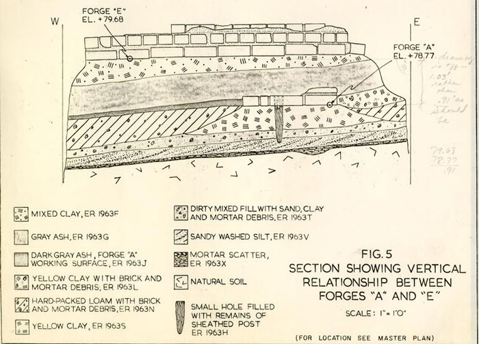 FIG. 5 - SECTION SHOWING VERTICAL RELATIONSHIP BETWEEN FORGES "A" AND "E"
37.
the Williamsburg area (ER 1963F). Beneath this clay, a level of domestic ashes (ER 1963G) sealed the destruction of Forge "A", and probably was deposited during Period II before Shop "A-1" had been enlarged northward.
FIG. 5 - SECTION SHOWING VERTICAL RELATIONSHIP BETWEEN FORGES "A" AND "E"
37.
the Williamsburg area (ER 1963F). Beneath this clay, a level of domestic ashes (ER 1963G) sealed the destruction of Forge "A", and probably was deposited during Period II before Shop "A-1" had been enlarged northward.
Fence D
Post holes defining a possible north-south fence line extending from the main house to the northeast corner of the shop were located and excavated (see Master Plan). These holes (ER 1957G, ER 1921Z, ER 1946Y, and ER 1910L) are located on eight foot centers, though an unexcavated gap conceals an area where an apparent 4'00" break (possibly a gate, see p.72) was located. The post mold for the last hole to the south (ER 1910L) would appear to have abutted the northeast corner of Shop "A-3" exactly 20'00" from the northwest corner.
It seems probable that this fence was added in order to maintain separation between the industrial work in the shops and domestic life in the buildings to the north. It can easily be seen as a replacement for Fence "C" (see p.31). The artifacts recovered from the fill in these holes contained only creamware as dating evidence, but do serve to associate the fence with the Anderson occupancy of the property.
Relation of Shop A-3 to Kitchen
If our assumption of a 20'00" width for this shop is correct, it becomes obvious that its eastern wall would have run directly behind and almost abutting the west side of the chimney stack for the kitchen. Nevertheless, meager archaeological evidence indicates that both structures were standing at the same time, and the Frenchman's Map corroborates this 38. by showing a small structure (probably the kitchen) to the east of the forge shops (see Figure 1).
Shop C
Coinciding with the construction of Shop "A-3," the small southern outbuilding (Shop "B") seems to have been dismantled and replaced by a larger shop containing two forges. Although the foundations for the latter structure [(ie of the shop, not forge)] had been robbed of most of their brick, the dimensions of the building can be estimated at approximately 25'00" by 16'00" (see Figure 4). The north wall of Shop "C" apparently abutted the southern wall of Shop "A-2," and perhaps shared it. Along the eastern side of Shop "C", however, there was a 5'00" setback between the two buildings, and it was perhaps this break in the line which explains the difference in alignment of the major "shop" blocks shown on the Frenchman's Map. The eastern foundation of Shop "C" was partially extant, and proved to be one brick or 9" wide, but as only one course survived, no bond could be determined. Constructed from a mixture of whole and broken bricks, the foundation was poorly secured with oystershell mortar. The footing was not set in a trench, but rather was constructed upon the previously mentioned iron waste deposit to the east of Shop "B" (ER 1975C, see p.30).
The south foundation was represented only by a 1'00" wide robber's trench (ER 1944G) which ran directly south of Forge "G." Although most of its length had been destroyed by earlier C.W. excavations, it was estimated to have extended to a distance of 16'3"′ As the west foundation was set much deeper, it seems most probable that this one had been stepped to a higher level, 39. as was demonstrated by both the southern and northern footings for the main shop structures (Shops "A-2" and "A-3").
Most of the west foundation had been robbed, and in turn the actual robber's trench (ER 1944Z and ER 1970B) was severely disturbed by a complex of later post holes along the western property line (see Figure 15). As with the eastern foundation, it is probable that the robber's trench had extended all the way to the southwest corner of Shop "A-2," though this juncture had since been destroyed by later disturbances.
There was evidence that a lean-to extension or overhanging roof projected from Shop "C" and was supported on a row of large posts. For details see p.44. [Probably [illegible] & not in 1780]
Aside from the fact that the eastern foundation for the shop was built on top of the iron waste, there is little dating evidence for its construction. It does seem likely, however, that it occurred around 1779 when Anderson's activities were rapidly expanding.
Forge F
Shop "C" contained two forges. Forge "F" was located in the center of the building, with its southern side abutting the line of the south wall of the by then dismantled Shop "B." Although all the forge's brick had been removed, its size (as delineated by the robber's fill) was 5'2" by 4'9", and it was flanked at all corners by small round pits (ER 1969B, ER 1975S, ER 1975R, and ER 1970S) which are believed to have supported tree stumps or some other firm base upon which an anvil would have been seated. As will be seen, this feature was common during the Period III construction.
Forge G
This was located against the robber trench for the shop's southern wall and was, for the most part, in good shape, having been disturbed only by the presence of two post holes which cut through two of its corners. The external dimensions for this forge were 5'3" by 4'6", though the varying width of the sides made the internal size considerably smaller, only 2'9" by 2'4". The north, south and east walls were all a brick and a half wide while the west wall was wider by a whole brick, again suggesting that it was the west side which supported the chimney or hood. Two small pits, similar to those flanking Forge "F," were found on the north side.
Little dating evidence for Forge "G" was forthcoming — beyond the fact that it had been built on top of and cutting through the remains of Forge "B" (see p.24).
Walk B
It seems probable that at some date during Period III, this brick walkway was laid along the eastern side of the main shop complex. Constructed from both whole and broken bricks, the walkway extended from the southern end of Shop "A-2" to a point near the junction of the first period-kitchen and Shop "A-3." The presence of paving in this location would indicate that access to the shops was from the south and east rather than from the north and Duke of Gloucester Street. For more data on this walk see p.65.
Clinker Spread
Located to the east of Shop "C" another distinct spread of coal dust and clinker was found (ER 1977F). This waste must 41. have been deposited during the life of the shop because the clinker was confined to an area outside its wall. It covered an area measuring at least 17'4" by 3'6", its full extent being undetermined due to incomplete excavation.
Post-1779 Features
The preceding account of the evolution of Anderson's shop arrangement offers the most likely interpretation of the archaeological data, and fits most readily into the portrayal of the site provided by the Frenchman's Map and Humphrey Harwood's documentation. As mentioned earlier, construction and repair work on Anderson's property continued after the war's end, and much of what follows is believed to relate to this post-Revolutionary period.
Forge H
During the 1931 excavations, a large brick feature was unearthed at the southern end of Shop "A-3," where it joined with Shop "A-1." Although nothing of this feature survived to be re-assessed in 1975, we may reasonably deduce that it represented yet another forge. This box was quite different from the other excavated forges, however, in that it was found to measure 8'4" long by 4'2" wide with an east-west orientation. The north and south walls were 9" (one brick′) wide, while the east and west sides were 1'1" (a brick and a half′) in width.
Projecting from the south side of this structure were two brick appendages, 1'1" wide and 3'11/2" long. As the brick used in the construction of these "legs" are shown on the 1931 plan as being the same as that used in the box, we may assume 42. that the two were related. Although there is no way of knowing exactly what function these protrusions served, it seems possible that they have some relation to the superstructure of the fire box. If this was, in fact, a forge, its different size and shape suggests a very specialized use — perhaps to work on large pieces which could be laid across its long axis.
Forge J
Of this only very fragmentary evidence was found. Located directly to the south of the modern garage was an area of brick rubble mixed with coal clinker and ash (ER 1973K). Removal of the fill revealed several bricks mortared together which helped to define the shape and size of the structure. It seems that the box had measured 6'00" by approximately 4'00", though the northern edge had been destroyed by the builder's trench for the construction of the garage and the west edge by earlier archaeological digging. There was no way to determine the thickness of three of the sides though the south wall was a brick and a half (1'1") wide, and from such scant remains, no dating clues could be drawn.
Working Level in Shop A-2
A level of black coal dust and ash (ER 1973P) extended between Forges "D" and "J." This fill contained enormous quantities of scrap iron and other waste materials which had apparently fallen onto the floor of the shop during its working life. The ashy fill was approximately 2-3" deep and was associated with the use of both Forges "D" and "J." It should be noted that this level sealed the large "barrel" holes (see pp.27-28) from the Period II construction, thus giving the 43. evidence needed to separate the life of Forge "D" into two periods. [Not necessarily so, as the clinker fill over the robbed remains of forge D could have been waste from its own operation, used as backfill after the dismantling. See pp. 27-28]
Bellows Support Holes (′)
A configuration of four post holes was found cutting through the ash floor level (preceding page) of Shop "A-2" to the east of Forges "D" and "J" (see Figure 4). From the appearance of these holes (ER 1973E, ER 1973F, ER 1973H, and ER 1973C), they had held posts driven into the ground rather than being set into previously dug holes, and therefore should more correctly be identified as post molds. Larger disturbances around these molds (ER 1973D and ER 1973G) apparently represented holes dug in order to remove the-driven posts, as the fill found in both molds and holes was identical. [NOT - opposition not correct. all of the fill would have been the same.] The placement of the posts formed a square measuring 2'00" on each side, and its proximity to both Forges "D" and "J" (2'00" from either of them) indicates that it supported a structure which bore a direct relationship to the operation of the forges. One distinct possibility would be that the posts held the frame for a bellows connected to both fires. Alternatively, the holes may represent the location of a heavy work table whose legs were driven into the ground for greater stability.
One of the post removal holes (ER 1973C) contained artifacts dating after 1782, indicating that this structure was dismantled no earlier. It is reasonable to suppose that the shop was abandoned at much the same time. [Shop was in use through 1798][how about forge only′]
Anvil Stands (′)
At three of Forge "D's" corners were found roughly circular holes averaging 1'6" in diameter and approximately 3-5" in depth. The fill in these holes (ER 1917A, ER 1972C, and ER 1973M) contained fragments of discarded iron waste and cut through the remains of the ash-strewn working floor of Shop "A-2." There was some indication of a fourth hole adjacent to the southeast corner of the forge (ER 1918C), though its exact size and shape was not well defined. Present thinking has it that these holes were seatings for a heavy base, such as a tree stump, upon which the smith's anvil would be placed. Although it might not be necessary to set such stumps into the ground, there is no denying that added support would have been provided. The presence of these holes on the north and south sides of the forge indicates that it was worked from at least two directions.
Possible Lean-To Addition to Shop C
Four post holes (ER 19771, ER 1975H, ER 1975K, and ER 1975M) were found to the east of Shop "C." The line of these holes coincide with the eastern wall of the main shop building (Shop "A")[No! does not] and it is believed that they supported a small shed addition or lean-to roof which was probably added at a date after the original construction of Shop "C." As such an addition would have given the row of shops a common eastern wall [wrong] rather than an offset, it seems likely that the posts were added after the Frenchman's Map was drawn in ca l781.
Destruction Level
[The post holes are 1-2 ft outside the east bldg line would have created an offset in just the opposite direction from what the Frenchman drew]
Overlying the ash working surface in Shop "A-2" was found a layer of brown loam and brick fragments (ER 1973A and ER 1973B), 45. probably representing the remains of the post-abandonment debris. In general, the artifacts recovered from this fill can only be said to date after about 1770, though one small sherd of whiteware dated the layer (ER 1973A) after 1830. However, the proximity of Colonial Williamsburg disturbances raises the possibility that this sherd may represent a contamination from a later level. The debris also sealed the removal holes for the bellows support which, as demonstrated earlier (p.43), dated after 1782. [illegible handwritten note]
Beam Slot
Cutting through the destruction level was a rectangular slot containing mixed loam fill (ER 1972A). This slot ran east-west, directly south of Forge "J," from the western wall to the eastern wall of Shop "A-2." The digging of this trench had cut through the backfill of the large hole associated with Forge "D" in Period II (ER 1973A), thus post-dating it. Were it not for the fact that the "beam slot" cut through Shop "A-2's" destruction debris, a case could be made for its once having held a timber which aided in supporting the shop roof by running studs from beam to rafters, forming a partition wall.
The James Anderson House
Although this season's excavations did not deal directly, with the archaeological remains of the main dwelling house fronting Duke of Gloucester Street (now the James Anderson Archaeological Museum), the date for its construction is of importance to our understanding of the site's chronology. Unfortunately, the indirect evidence available from historical 46. and archaeological sources, conflicts. As we demonstrated in the historical introduction (pp.6-7), Williamsburg historians have concluded that this structure was probably constructed around 1760. The data used to substantiate this is not, however, clear cut and is certainly open to some valid question. In fact, the strongest evidence, historically, is the nearly 100% increase in the value of the lot between 1760 and 1770. The advertisement of Freer Armston which refers to Mrs. Rathell cannot be taken as positive evidence of a western structure. Little is known historically of Mrs. Rathell and it may be erroneous to assume that she was on Lot 18 when she may well have had a shop on Lot 17, thus leaving the western side of the property open.
The archaeological evidence, on the other hand, may be a bit more reliable; though the information available is far from conclusive. The most direct evidence for the construction of the building is a sherd of creamware found beneath the box drain to the west of the structure (see p.56). It has been discovered on other sites in Williamsburg (e.g. The President's House) that these corner drains were built at the same time as their associated buildings; consequently this sherd of creamware would indicate a post ca.1770 construction date for the main house.
In addition to this information, the fill sloping in the ravine may provide even further proof for the later date of construction. Directly south of the present building, a stratum of brick and mortar rubble (some of it burned) containing sherds of creamware was found (ER 1921T and ER 1957L). 47. In addition, farther to the west, a deposit of plaster debris (ER 1939K and ER 1949E) was also located. Although the artifacts in this level dated after 1740, its stratigraphic location provides a more reliable picture of its temporal association. Both the rubble layer and the plaster level lie on top of the thick deposits of domestic refuse which, as is seen later in this report, accumulated between ca.1760 and ca.1775.
Above the rubble level, a stratum of yellow clay containing fragments of brick, mortar and ash was found. This level was extensive and covered an area approximately 50'00" by 60'00" (though its spread was not regularly shaped), and varied in depth from 7" (ER 1957K) to a thin scatter (ER 1937J). The stratigraphic association with the brick rubble and plaster points to a combination of destruction and construction, with the rubble level representing the dismantling or renovation of a structure and the clay spread being from the digging of the cellar for a building.
Once again, this clay level contained artifacts indicating a post-1770 deposition date. Above the clay (and in some cases mixed with it) the fill was predominantly a spread of industrial clinker and ash. Thus, from this stratigraphic data we can reconstruct a picture of the activity on the site which does not readily agree with the above interpretation of the historical data. It would seem to follow from this information that sometime after Anderson's purchase of Lot 18 he undertook some changes in the existing structures along Duke of Gloucester Street and then followed this with the construction of the main building, which first appears for certain on the Frenchman's Map ca.1781.
48.There is, unfortunately, no way of proving or disproving the existence of another structure which may have pre-dated the Anderson construction. The change in the property's value between 1760 and 1770; the fact that both Christiana Campbell and William Drinkard had taverns on the site; and the reference to William Holt living on the property, would all seem to point to more intensive occupation than was evidenced previously, and would possibly point to the construction of a new structure (for which there is no archaeological evidence) or the expansion of the existing shop. As will be shown later (p.50), it is most probable that Holt constructed the First Period Kitchen during this decade, which may help explain the increased value. Be that as it may, we are still faced with too many activities for the existing structures, and it can only be left as conjecture that there was another structure on Duke of Gloucester Street which burned during or after Drinkard's tenancy or which Anderson dismantled in order to build his own house ca.1775 when he began to expand his shops onto the lot.
Smokehouse
The archaeology of the smokehouse reconstructed in 1940 can only be understood in relation to the topography of, and the fill within, the natural ravine beside and over which it was located (Figure 6). As was the case with most features re-examined during the 1975 season, any and all evidence of post-destruction debris was lacking. In fact, with the smokehouse even the original brick was gone, replaced by a remarkable modern foundation set 5'00" into the ground to raise the building to coincide with the grade elevations demanded by the 49. reconstructed James Anderson House. An examination of the photographs of this structure taken during the 1931 excavations noted several feet of stratified fill immediately adjacent to it. In fact, elevations given on the 1931 plan showed that the foundations for this smokehouse were located 5'00" below the modern grade. It became our belief (and this was proved true) that the smokehouse did not belong to the period of the James Anderson House but was, instead, an earlier structure built before the ravine was filled.
Although none of the original brick survived, the 1931 plan showed that the building had measured 8'1" by 8'1" and stood on a one-brick,(9") foundation.
The 1975 excavations removed 5'00" of C. W. fill from within the reconstructed smokehouse in an attempt to determine if any associated, and previously unrecorded, features survived at the level of the original brick. Fortunately, such a feature was found in the form of an ash-filled pit 2'00" in diameter and 1'6" deep (ER 1920A). Artifacts from this pit crossmended with others found in a silt level associated with the filling of the ravine (ER 1922T), providing a ca.1755 terminus post quem for the destruction of the smokehouse. It can safely be concluded, therefore, that this structure, rather than being associated with Anderson's occupation, in fact, dates much earlier than any of the other structures identified on the site, and must have been associated with a dwelling in use prior to 1755.
From the historical record it is difficult to determine what structures, if any, were located on the site during the
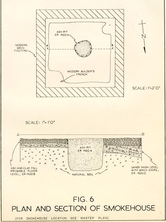 FIG. 6 -
PLAN AND SECTION OF SMOKEHOUSE
50.
early years of the development. It seems most likely that prior to 1760 the only dwelling on the site was the 20'00" by 30'00" "shop" building located on the east side of the lot, facing Duke of Gloucester Street, but it cannot now be determined whether or not this building was associated with the smokehouse.
FIG. 6 -
PLAN AND SECTION OF SMOKEHOUSE
50.
early years of the development. It seems most likely that prior to 1760 the only dwelling on the site was the 20'00" by 30'00" "shop" building located on the east side of the lot, facing Duke of Gloucester Street, but it cannot now be determined whether or not this building was associated with the smokehouse.
First Period Kitchen
The Frenchman's Map of ca.1781 shows a small structure east of the two "forge shops." Excavations in 1931 revealed the base of a brick chimney with its internal open end facing to the east (Figure 7). Preliminary digging in 1974 re-exposed this structure, along with two flanking sections of the western wall, and it was anticipated that expanded excavations in the summer of 1975 would expose and date the remainder of the building.
The chimney base measured 9'00" by 5'1" (its large size indicating that it belonged to a kitchen), and was built with large, well-fired brick, secured with oystershell mortar, and set into a substantial builder's trench. Unfortunately, the 1931 excavations had removed all of the fill surrounding the surviving courses of the chimney, thus obliterating any potential information concerning its date of construction.
When the area to the east of the chimney was opened, it was found to be literally chewed up by modern and nineteenth-century disturbances. A large hole, dug for a modern well (see p.65) was located in the center of the kitchen. Extending eastward from the western wall sections abutting the chimney were Colonial Williamsburg archaeological trenches of such depth as to obliterate most of the remains of either walls or 51. their robber's trenches. We were fortunate, however, in that the trench dug on the building's north side went slightly askew from the kitchen's wall line and permitted the very fragmentary remains of a possible robber's trench to survive (ER 1933K and ER 1933L). In fact, enough of it remained to identify a corner and thus establish the building's dimensions: 16'00" by 20'00". To substantiate the validity of this finding, another section of the robber's trench was located along the kitchen's eastern side (ER 1947E).
Although a firm date for the construction of the kitchen was not obtained, an indirect date, relative to other features was established. The location and excavation of a post hole extending beneath the southern leg of the western wall yielded artifacts dating the backfilling of the hole to post ca.1740 (ER 1962A). Thus, the only dating evidence for the structure puts it on the site anytime after 1740. In addition to that hole, however, another series of post holes was located running east-west across the site (see Figure 7). Three of the holes were located west of the kitchen with one post mold actually abutting the southwest corner of the building (ER 1912B). Three others were located to the east with one almost exactly at the supposed southeast corner of the kitchen (ER 1934D). It appears therefore, that this fence (Fence "C" on the Master Plan) was constructed to divide the yard, and made use of the kitchen's southern wall. Artifacts retrieved from these post holes dated the fence's construction no earlier than ca.1770, though as demonstrated on page 26 Fence "C" was most likely a part of the ca.1777 construction associated with Anderson's second 52. period of shop evolution. We can surmise from this information, therefore, that the kitchen was on the property when Anderson acquired it, and that it pre-dates Fence "C".
No evidence for an earlier kitchen was found in either the present excavations or in those of 1931. Certainly if Christiana Campbell were operating a tavern on the site from ca.1760, a kitchen would have been necessary. Prior to that date, when apparently only a shop was located on the property, a kitchen might not have been needed. Thus, based on historical inference and the archaeological knowledge that the kitchen was constructed after 1740, a reasonable hypothesis can be made that the structure was erected around 1760 when William Holt acquired the property.
Brick Drain Tunnel B
An interesting feature of the kitchen was the location of an entrance to a brick drain situated inside the northwest corner of the building (Figure 7, inset). Careful examination of the construction of this drain in relation to the kitchen's west wall revealed that the drain was added later at a date as yet unknown. All indications pointed to the northern leg of the western kitchen foundation being dismantled, except for the bottom course, and then replaced as underpinning after the construction of the drain. Furthermore, it was the drain which provided the needed evidence to establish that brick and a half (1'1") thickness of the kitchen's northern wall. The drain did not enter the kitchen directly from the north but instead had a flow line oriented slightly to the northwest. 53. The actual arched section of the drain's tunnel, however, ran straight east-west. This caused the drain entrance within the kitchen to be irregular in shape, but at the same time provided evidence for the width of the kitchen's wall. When it was added, the arch of the drain itself was used as an underpinning for the kitchen's sill.
Further data on this and associated other drains will be presented later in the report (p.56). Suffice it to say at present that it seems that this drain was added sometime late in the eighteenth century.
Related Walkway
To the north of the kitchen a section of a brick path (Walk "A", see p.64) was uncovered. This walk was laid over a shallow erosion gully which contained fragments of Rouen faience in its silty fill, a ceramic type not found in the colonies prior to ca.1775, and which thus helps date the construction of the walk. This path may well have been added in Period III and be contemporary with Fence "D" through which it most probably passed (see p.37).
Evidence of Kitchen Removed
No accurate date for the kitchen's destruction was obtained archaeologically. None of the remnants of the robber's trench contained datable artifacts and, as mentioned above, the entire area was riddled with disturbances. Possible evidence of moving, dismantling, or interior renovations was provided by a layer of plaster debris spreading north of the building (ER 1928N). Associated artifacts date this layer to post 1782, thus raising the possibility that Anderson moved 54. the kitchen from the center of the yard to its present location after his return from Richmond (and also after the drawing of the Frenchman's Map). Support for this interpretation is provided by the close similarity between the foundation and chimney base measurements of both buildings. It is possible that Anderson moved the kitchen in order to expand his shops, though as we have seen earlier, his shops seemed to have reached their northernmost extension prior to his sojourn in Richmond. The closest we are able to date the removal of this building then would be to a date between 1782 and 1810.
Summary
The evidence points to a frame kitchen structure with an external chimney having been constructed around 1760, and to a fence being erected across the southern side about 1777. Sometime after 1775 (probably long after), a drain was added to the kitchen, necessitating the underpinning of its western and northern walls. Sometime after 1782, and before 1810, the structure was replaced by a building of similar size along the eastern property line.
Second Period Kitchen
The 1939 excavations on the eastern side of the property revealed the remains of a probable kitchen structure measuring 16'00" by 20'00" with a massive external chimney located at its southern end (Figure 17). Because a reconstructed kitchen now occupies the location, no archaeological data was obtained during the 1975 project to aid in determining a date for its original construction. The remains of Walkway "C" (ER 1925E), 55. which apparently dated after 1805, represent the only feature which may be related to this structure. Historically, however, there is some indication that this kitchen was constructed by Nancy Camp, ca.1806 (see p.11).
To the south of this building a series of slots into the subsoil were located. These depressions were not uniform in size, generally 9-11" wide by 1-1½" deep and from 3'00" to 5'00" long. It was originally suggested that they represented the rudimentary remains of a system of sleepers and rollers used to move a structure — perhaps the kitchen. It would seem that the located slots would have marked the position of the east-west oriented sleepers upon which the building was moved. This would then indicate that the structure was moved from west to east (or east to west) raising the question of whether these features were, in fact, at all related to the Second Period Kitchen. Artifacts from these slots and the soil level above them (ER 1966A) dated after 1770, but probably not as late as the first decade of the nineteenth century. For this reason, it seems unlikely that these slots had any association with the kitchen.
The only other explanation which comes to mind for these features would be that they are the remains of a crude structure resting on wood sills which left rough impressions in the earth. Because the located slots do not form any definite shape, the plan for such a possible structure could not be ascertained.
Drainage System
As has been seen earlier, after ca.1755 the ravine to the west of Lot 18 became a major repository for the garbage from the occupants of the site. This gradual change in the gradient undoubtedly altered the run-off pattern for rainwater, and in consequence, the number of water-washed silt levels found directly south of the James Anderson House ranged in date from ca.1755 to ca.1770. With the commencement of Anderson's activities on the site, the nature of the fill in the ravine changed from domestic to industrial waste, but there is still evidence that the site was subject to erosion caused by the interruption of the natural drainage. Sometime during Anderson's tenure the problem became acute enough for the installation of an elaborate system of drains, which was incorporated into the entire block.
Box Drain
The only feature excavated during the 1975 season which had direct relation to the main dwelling fronting on Duke of Gloucester Street was a brick drain (Figure 8). This drain was located on the west side of the reconstructed James Anderson House and was apparently used to drain water from the basement of the colonial structure located on the west side of the property. The drain measures 1'8" wide at its base and was constructed in four courses. The bottom course, which served as the drain floor was built with bricks laid as headers (when viewed from the side). The two courses of the sides were laid as stretchers while the top was laid in rowlock bricks capping the two sides, thus creating a drain whose interior measured 7" by 8". The bricks were a light reddish-orange in color and
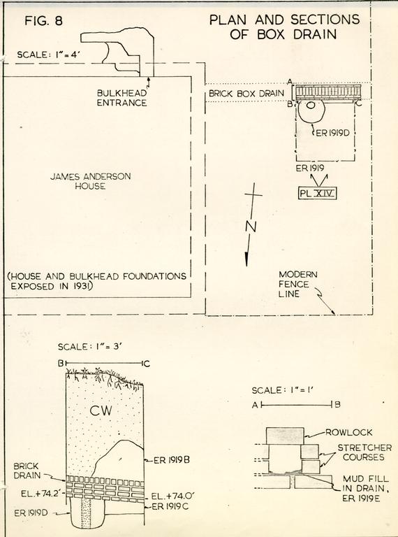 FIG. 8 - PLAN AND SECTIONS OF BOX DRAIN
57.
were bonded with a light gray shell mortar. Based upon the 4'6" section uncovered, the drain had a gradient drop of 5" in every ten feet.
FIG. 8 - PLAN AND SECTIONS OF BOX DRAIN
57.
were bonded with a light gray shell mortar. Based upon the 4'6" section uncovered, the drain had a gradient drop of 5" in every ten feet.
Most of the 6'00" of fill overlying the drain had been disturbed, although it does not show on the 1931 plan. A large post hole was located beneath the drain (ER 1919D) and must have been associated with a fence line pre-dating the drain. A layer of mottled gray, sandy loam underlay the drain (ER 1919C) and contained a fragment of creamware, thus dating the drain's construction after 1770. This is very important in the light of the uncertain date for the large house, which is likely to have been constructed at the same time as the drain.
Drain Tunnel A
The main component of the drainage system installed on the site was a massive, arch-roofed brick tunnel which entered the site from the east and exited to the west. The entire length of this drain had been previously excavated, making it impossible to determine through which levels it had been cut, and thus it was impossible to date its construction.
The tunnel was well built, consisting of a brick floor approximately 3'2" wide; on either side a two course high wall was capped with an arched roof, one brick in thickness. At irregular intervals along the crown of the arch, the construction was broken by sections of brick which appeared to have been plugged into the drain, possibly serving much the same purpose as a closer in a brick wall. The internal dimensions 58. for the drain were 1'1" wide by 1'2" high. The drain was devoid of any fill, other than a few scattered chips of bone, brick, and one piece of burned pearlware.
At the eastern side of the yard, a brick box entrance to the drain was excavated (see Figure 9). The tunnel entered this box from the east and exited at a slight northwesterly angle to the west. At the base of the entrance was a single slab of cut sandstone. At the top another surface drain entered from the west and was built from another slab of sandstone resting upon the western edge of the drain entrance and flanked by two bricks. Unfortunately, all the surrounding fill had been disturbed and no further evidence of this drain was located.
The purpose of the drain's entrance would seem to have been to receive rainwater from the relatively level ground surface to the east of the yard. With the build-up of the fill within the ravine, the natural drainage (which normally would have prevented any serious problems) was cut off, perhaps causing flooding at the eastern side of the property. The addition of the drain, with an entrance located in the most heavily traveled area of the property, would have alleviated the problem.
Drain Tunnel B
As previously noted, another tunnel drain was excavated during the 1931 excavations, this beginning inside the First Period Kitchen and running northwest to intersect with Drain Tunnel "A." That intersection was not excavated during the current project, though the entrance to the drain was uncovered 59. in order to establish its relationship with the kitchen structure (see p.52).
Clearly this drain was not designed to control rainwater but was intended for the disposal of liquid wastes from the kitchen. Like the larger drain, however, no fill (other than that from the backfilling of the 1931 digs) was found in association with the tunnel; and no date for its construction, use or abandonment could be determined.
Brick used in the construction of both Drain Tunnels "A" and "B" was similar, as was the mortar. It is interesting to note, however, that two distinct types of mortar were used in the building of the drains. In both was found a mixture of a buff-colored, soft, shell mortar, containing large fragments of shell, and a much harder grayish mortar with very small pieces of shell; but no pattern could be ascertained to determine if the different mortars were used for special purposes. This similarity of brick and mortar points to a simultaneous date for the construction of the two tunnels.
Early Brick Drain (′)
One baffling feature uncovered during the year's excavation was a line of laid bricks, one brick wide and one course deep, over most of its length. This feature was previously exposed by the 1931 excavations and found to extend for a distance of thirty feet. The brickwork rests on subsoil directly south of the path of Drain Tunnel "A," and is cut through by (thus pre-dating) Drain Tunnel "B." Just west of this intersection, the brick course turns slightly to the northwest and 60. increases in height to a second course. At this point the brick reaches the eastern limits of the ravine fill and there overlies a layer of ashy fill (ER 1946Z) deposited after 1750 and thus providing a terminus post quem for the brickwork.
There is little likelihood that the brick was structural. Not only does the line angle west of Drain Tunnel "B," but the bricks are unmortared. The only reasonable explanation is that the brickwork is all that remains of an early drainage system for the eastern side of the yard. This idea may be supported by the existence of an erosion gully just south of the brick which dates from the same period and could have led to the installation of this feature.
Wells
It was hoped that the excavations would reveal a well attributable to the James Anderson period. Excavations on the east side of the property in 1939 had discovered a backfilled shaft beneath the since reconstructed kitchen, a building constructed prior to 1810, probably in the first decade of the nineteenth century. It therefore follows that the well shaft must have been backfilled prior to that date. With its proximity to the 20'00" by 30'00" shop building fronting on the Duke of Gloucester Street lot's east side, this shaft may have been dug in the second quarter of the eighteenth century and could have been used until the First Kitchen was moved.
Well A
While excavating fill from the southern side of the brick drain entrance, a large quantity of rubble lying in an apparent hole was discovered. As this area was expanded, a disturbance 61. approximately eight feet square was found abutting the south side of the drain (see Figure 9). Removal of accumulated soil levels at the surface of this disturbance unveiled a concentration of brick rubble covering the square area. As the top of this hole was already below the level of the subsoil, it was surmised that it was the upper extremity of a backfilled well shaft. Removal of the top loose rubble revealed large sections of a mortared brick lining constructed of "compass" bricks along with three large pieces of the well head. The condition of this lining was deplorable at best, having been likened to the effects of a bomb thrown into the shaft. Entire mortared sections of the lining were oriented at all different angles, with no indication of where the actual shaft was located.
There was evidence that some sort of repair work had been performed on the well head, whose orientation had apparently been shifted slightly, for in the southwest corner there was evidence of two periods of construction (Figure 9, inset).
The continued removal of the rubble fill (which necessitated the dismantling of large chunks of the lining and well head) led to a very startling and unexpected find. At a depth of approximately seven feet below modern grade, all traces of the brick ceased, leaving only an area of dirty mixed clay. It was decided that continued excavation would be dangerous until new plans could be made for the protection of workers digging in the hole. Its exploration had not been resumed at the season's end.
Excavation of the stratified fill around the surface of the well revealed a level of spread marl which may have served 62. as a paving adjacent to the shaft. It is also conceivable that this marl was derived from the excavation of the well itself. As artifacts retrieved from the marl date after 1805, they might also provide a terminus post quem for the digging of the shaft. Such dating is reasonable in the light of the presumed date for the construction or moving in of the second period kitchen, i.e., ca.1806. If, as was stated previously, the earlier well (beneath the kitchen) was used until that time, then immediately upon the filling of the shaft there would have been a need for the sinking of a new well. It may be noted in Robert Anderson's 1812 account books an entry " ... work for well..." at Nancy Camp's. Was this the reorientation of the well head mentioned above′ It seems reasonable to assume that it was, thus putting this shaft in use both prior to 1812 and for some time thereafter.
When and why was the well abandoned′ The condition of the shaft would indicate that it collapsed, rather than being purposefully abandoned and backfilled. Artifacts in the rubble fill dated post-ca.1810 (ER 1926M), though as indicated above, it seems most unlikely that the shaft was filled that early. Some of the overlying fill contained artifacts manufactured as late as ca.1830 (ER1926D) which would make better sense as a destruction date. This fill, however, was most likely added to the shaft after the original backfill had settled and compressed. On the basis of the small amount of information presently available (and without complete excavation), a destruction date between 1810 and 1840 seems reasonable.
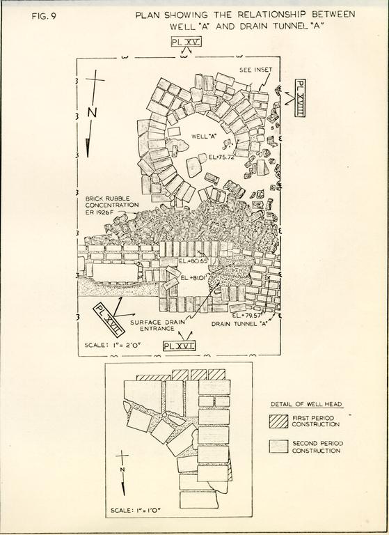 Figure 9 - Plan Showing Relationship Between Well "A" and Drain Tunnel "A"
Well B
In the center of the First Period Kitchen foundation was found the brick-lined remains of a modern well (ER 1940). The shaft was lined to a depth of approximately 6'00" with machine-made brick neatly laid as stretchers (Figure 10). Below that level, the quality of the brickwork was poor with the brick laid as headers to a depth of 12'01" and as stretchers again below 19'06". The diameter of the shaft was 3'09" at the top, tapering to 2'02-½" at a depth of 20'00". The hole was not circular, but was instead, roughly oval in shape. The side had partially collapsed, forming a hole beginning at approximately 12'00" and continuing to a depth of 17'00" (not on section).
Fill within the shaft was virtually the same from the top to the point at which the excavation was abandoned, and comprised dark loam mixed with large quantities of trash. The artifacts included a great number of modern bottles which dated the backfilling of the shaft to ca.1928-1930, along with cups and saucers and related ceramics suggesting that this was all refuse from the cafe which stood on the Anderson House site in the 1920s. Due to the fill's late date, it was decided to abandon excavation at a depth of 23'00" below modern grade.
A large hole 6'00" by 5'00" had been dug con the construction of the shaft. The brick itself had been laid against the west side of this hole which tapered inwards until, at a depth of 7'00", it was a mere 06" to a foot wide around the east side of the shaft.
Walks
The remains of several walkways, dating from both the
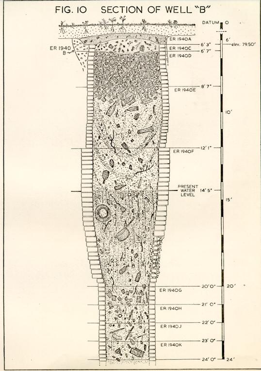 FIG. 10 - SECTION OF WELL "B"
64.
eighteenth and nineteenth centuries, were unearthed during the course of the season's excavations. These paths were helpful in obtaining some dating evidence for structures and in suggesting the locations of doorways.
FIG. 10 - SECTION OF WELL "B"
64.
eighteenth and nineteenth centuries, were unearthed during the course of the season's excavations. These paths were helpful in obtaining some dating evidence for structures and in suggesting the locations of doorways.
Walk A
Just north of the First Period Kitchen a short section of a brickbat walkway was uncovered (Figures 7 & 17). This paving almost certainly was found during the 1931 excavations (there was Colonial Williamsburg backfill above it), but for some reason it does not show on the plan drawn at that time. The walk was 2'3" wide and survived for a distance of only 2'6", oriented in a generally northwesterly direction from the center of the kitchen's north wall. The walk had been laid over a shallow silted erosion gully, the fill comprising washed sand containing artifacts dating after 1775, thus providing a terminus post quem for the construction of the walk.
There is little doubt that this path served the kitchen at its northern side and led to a doorway in the center of the wall line. Much more difficult to determine is the location of the path's northern end. It can hardly have led to the main dwelling as it skirted too far to the west. However, no structures dating to the fourth quarter of the eighteenth century were found in the direction the walk leads. It is possible that there was a gate in the north-south fence line which ran from the northeast corner of Shop "A-3" to the main dwelling house (Fence "D", see p.72). If such a gate did exist, Walk "A" would run right to it, thus providing access to the ravine.
Walk B
A brick walkway was uncovered during the 1931 excavations along the east side of Anderson's shops on the western side of the property (Figure 4). This walk was partially re-excavated in 1975 revealing its width in an area to the east of Shop "A-2." Haphazardly laid with a variety of whole and broken bricks, the walk had a width of 2'6" and was mortared together with oystershell mortar.
The 1931 plan indicates that this path extended from the southeast corner of Shop "A-2" northward to a point just short of the First Period Kitchen's chimney base. Two conclusions can therefore be drawn: 1) Shops "A-1," "A-2," and "A-3" were probably in existence and represented one long structure when this walk was laid, and 2) the approach to these shops was from the south, with Walk "B" terminating in the recess formed by the kitchen's west wall and Shop "A-l." It follows therefore that if the walk was laid after the construction of Shop "A-3," it belongs to Period III and to a date no earlier than ca.1779.
Walk C
During the 1939 excavations on the eastern side of the property, a section of a laid brick walkway was found extending westward from the Second Period Kitchen (Figure 17). It was at that time assumed to connect the kitchen to the forge shops; though, as has been demonstrated, this kitchen almost certainly post-dated their destruction. After the completion of the 1939 project, the brick from this walk was removed leaving only a spread of brick and mortar (ER 1925E) to mark its previous 66. location. Although artifacts from rubble fill dated after 1790, the layers beneath provide a clearer picture of the walkway's true date. A level of grayish sandy fill (ER 1925H) was found directly beneath the rubble and yielded artifacts dating after ca.1800. The most significant layer, however, was a stratum of marl, probably associated with the digging or use of Well "A" (see p. 60), and which contained artifacts manufactured no earlier than ca.1805. Thus, the walk can be dated after 1805 and may well have been contemporary with the construction of the kitchen, ca.1806-1810.
Walk D
The rotted remains of a boardwalk running in a north-south direction across the site were found during the 1975 digging (Figure 17). This boardwalk was constructed of horizontally laid cypress planks nailed to runners which kept them off the ground. The west side of the walk was found to be lined with broken bricks, but because the east side remained hidden in an unexcavated balk, there was no knowing whether similar broken bricks flanked it on that side. The remains of the walk were greatly disturbed, leaving only very slim evidence for its date of construction. One section was sealed by a level which dated after 1830 (ER 1929E), while another was laid over a stratum which dated after 1805 (ER 1928H), thus suggesting a bracket of 1805-1830 for the life of the walk.
Where this walk led is not clear, though one of the possible privy pits (ER 1945G) located south of the First Period Kitchen (see p.74) lies just west of the walk and was filled after 1810. It is suggested, therefore, that this boarded 67. walkway provided access to the privy across the muddy yard area during a period when the First Period Kitchen was being removed and the Second Period Kitchen made ready. Belief in the temporary nature of the boardwalk is supported by evidence provided by a section of Walk "C" which cut into the remains of the boardwalk (ER 1928E cuts ER 1928F). As has been demonstrated above, Walk "C" almost certainly was constructed at the same time as the second period kitchen; thus, it would appear that the boardwalk was only in use for a very short time.
Fence Lines
In the course of the 1975 excavations over two hundred post holes and post molds were located, recorded, and excavated. A majority of these holes were concentrated in series delineating several periods of fence lines marking the western and eastern property boundaries and making internal divisions of the lot.
Western Property Line
A great number of post holes were revealed along the western property line representing the boundary from the early eighteenth century up to modern times. As most of the holes cut through one another and represented so many fences, only the two earliest lines are covered in this report.
Fence A
The first period fence on the western property line consisted of large round holes, usually with sloping sides, with the posts located on 8'00" centers (Figure 17). In a few of these holes the remains of the post molds were located and found to have irregular shapes, somewhat resembling a log split 68. into thirds. [Would not fourths seem more likely considering the difficulty involved in splitting of an odd number of sections′] The large clay-filled holes were partially sealed by a level of dumped yellow clay which apparently dated after ca.1750. This terminus post quem is substantiated by the artifacts recovered from the holes' fill which point to a construction date of post ca.1735-1740. This is interesting because there is no indication of an earlier fence line. One of the stipulations for ownership of property in the early days of Williamsburg's history was to enclose the "Lotts or half Acres with a Wall Pales or Post and Rails within six Months after ye Building which ye Law requires."35 From the archaeological evidence, it would appear that Ravenscroft did not fulfill that obligation. The possibility should not be ruled out, however, that he merely enclosed the lot with a simple split rail fence which would not have left any archaeological evidence. As has been demonstrated in both the history and archaeology, Lot 18 enjoyed no recorded activity prior to at least ca.1735-1740, and therefore, such a rudimentary fence may well have sufficed. With the construction of the shop on the eastern side of the lot and the smokehouse to the west (prior to 1755), there became a need or desire to improve this property line, hence the construction of the post fence. In fact, the split log vertical posts may have been re-used from the original fence.
At any rate, this fence extended the length of the western property line in all areas investigated, and it can be assumed that it stretched from Duke of Gloucester Street to Francis Street. The holes represent the earliest features excavated during the year and serve as further evidence for a lack of cultural activity early in the eighteenth century.
Fence B
All along the length of Fence "A," a series of rectangular holes were found cutting into round post holes. These later holes delineated the second period fence line along the western property line (Figure 17). Also located on 8'00" centers, they contained the typical mixed fill found in colonial post holes and yielded artifacts offering a terminus post quem no earlier than 1755. This construction date for the fence fits well into the pattern for the beginning of cultural activity on the site. It is probable, therefore, that simultaneously with the erection of the First Period Kitchen, the fence line was also replaced. These holes cut through (thus post-dating) the dumped clay fill that sealed the Fence "A" holes. At the same time these Fence "B" holes were dug, the ravine was just beginning to accumulate fill, and thus, all the holes are sealed by domestic waste dating after 1755.
Garden Fence
During the same period that Pence "B" was impaling the western property line, another was constructed to the east of it. Post holes located on 8'00" centers were found extending 62'00" in a north-south direction on a line 10'00" to the east of Fence "B" (Figure 17). This fence began at a point inside the northern end of the modern garage and extended to a point just south of the present east-west property boundary at the rear of the lot. At the southern end of this line of holes there is only a 5'00" gap separating the last two holes, then an apparent turn to the east and a gap of 4'00" to the first hole in that direction.
70.Although this line was definitely established on its western side, limited excavation along its possible southern and northern ends prevented positive identification of associated holes. All those located were sealed beneath the level of gray sandy loam, deposited from ca.1760 to ca.1775, and so must pre-date this deposition.
It is suggested that the fence created a rectangular enclosure within the yard area, measuring perhaps 67'00" by 62'00". Not until further excavations have been undertaken can the true nature of this fence be determined, though it could well have protected a garden area from foraging animals. It seems, therefore, that the fence was in use after Lots 18 and 19 were divided in 1760 and most probably existed throughout the following decade.
At a point 22'00" from the apparent southern end of this fence, two small post holes (ER 1985C and ER 1972X) were found in the "alley" between the western fence and the impaled "garden." Although it is not known what these holes represent, it is possible that they held a gate separating the northern end of the property from the southern end where there was a privy during this time period (Privy "B", see p.74).
Later Fence Lines along the Western Property Boundary
The next innovation along the western property line was the construction and evolution of James Anderson's shops. The western wall ran directly down the fence line and several of the holes for Fences "A" and "B" were found beneath it. All later fence lines ran just west of the wall, and as mentioned above, presented such confusion of intersecting holes that 71. it became virtually impossible to sort them into meaningful sequences. For that reason, the holes have been deleted from the overall plan of the site, but are shown in Figure 15 with a list of their terminus post quem dates.
Eastern Property Line
Only one area was tested during the season which was located along the property boundary on the eastern side of the lot. Although several post holes were uncovered and excavated, it was not possible to positively delineate a particular period of construction.
Fence C
A series of post holes was found flanking the southern side of the First Period Kitchen (Figures 3, 7, and 17). The posts for this fence were located on 8'00" centers and crossed the site east-west. Artifacts found in the post holes dated the construction of the fence line to post-1770, and therefore after Anderson's arrival on the site. The fact that this fence was added during Anderson's ownership suggests that he may have wished to separate the lot between the domestic activities to the north and the industrial activities to the south. As brought out earlier in this report (p.25), it would appear that this fence was associated with the 2nd period of Anderson's shop evolution, thus dating it to ca. 1777. It does not appear to have been in use for long, as the construction of Shop "A-3" cuts across the western extension of the fence and was probably moved to a new location.
[Are we to assume the entire fence was abandoned because the portion west of the Per. I Kitchen was made obsolete by the construction of Shop A-3′ The sect. east of the kitchen ... cut-off]
Fence D
This may well represent the reorientation of the east-west fence line (Figure 17). It was delineated by the location of 4 post holes running in a line from the main dwelling to the northeast corner of Shop "A-3." Artifacts date the erection of this fence to post-1770, though its probable relation with the Period III construction of Shop "A-3" would date it around 1779.
Although the four post holes did line up, the distances between them were not constant. Between ER 1921M and ER 1921Z the distance is 8'00". There is then a gap of unexcavated fill between this last hole and ER 1946Y, followed by another 8'00" gap to the post mold for hole ER 1910P. It may be conjectured, therefore, that the posts for this fence were located on 8'00" centers, possibly with a gate located in the span which was not excavated (due to the knowledge of the entire area having been removed during the 1931 excavations). A gate would account for the 4'00" discrepancy noted in the unexcavated gap. Though this gate is purely conjecture, it should be noted that if Walk "A" (p. 64) is extended along its northwesterly axis it would pass directly through this presumed break in the fence. As we have seen earlier, this walk was dated to post-1775 and could therefore have been in use at the time the fence was erected.
Fence E
Apparently sometime after Anderson's death and the removal of his shops from the site, an east-west fence was constructed across the site. The holes which possibly delineate this 73. fence are shown on Figure 17, though due to the incompleteness of the excavation along this presumed fence line, it was impossible to determine which of the holes were related. As mentioned earlier (p.11), Nancy Camp apparently constructed a fence in 1812 and it may be reasonable to assume that Fence "E" represents the one erected at that time.
Other Post Holes
In several areas of the site (most notably, ER 1929, ER 1930, and ER 1932) the masses of intersecting holes, often further confused by modern disturbances, were impossible to interpret, though a few general trends could be seen (Figure 16).
An apparent east-west fence was located along the southern wall of the First Period Kitchen. Artifacts recovered from several of these holes dated later than 1782. It may be reasonable to assume that after the kitchen was relocated (ca.1806), a fence was constructed across the yard to intersect with the southern end of the new kitchen's chimney base. Presumably, this fence was later replaced by Fence "E".
There are some indications of a possible north-south fence in ER 1930, though no other areas were investigated in the line of these holes. It may date from the late 19th century when the lot was divided into the Canaday and Moseley properties.
Figure 16 shows the conglomeration of post holes located throughout this area of the yard.
Privy A
One of the earliest features located on the site was a circular depression filled with mixed loam (ER 1985B) found beneath the western wall of Shop "A-2." The pit itself was 74. not regularly shaped and only 6" in depth, which may cast some valid doubt on its being interpreted as a privy. The fill contained many fragments of a Westerwald chamber pot, however, which would possibly indicate some functional use.
The pit was sealed by a deposit of dumped yellow clay which was found to date post-ca.1750 (ER 1972V) and thus falls within the first period of known occupation on the site. No structural evidence in the form of post holes, brick footings or soil stains was found in conjunction with this pit.
Privy B
Located at the southern end of the alley between Fence "B" and the Garden Fence was found a rectangular pit, 4' by 3'2" and 8" in depth (Figure 17). The pit was sealed by a level of gray sandy loam (ER 1970Z) which dated post-1760. The southern wall of Shop "B" had been constructed on top of the pit and settling of the fill may have caused the partial collapse of the wall as noted on page 23.
Fill within the pit was stratified into two levels of gray sticky loam separated by a level of clay. The upper level (ER 1981K) contained numerous artifacts including fragments of Whieldon pineapple ware, providing a post-1760 date for the filling of this feature. The association of the Garden Fence and Fence "B" with the pit indicates that it was in use during the decade 1760-1770.
As with Privy "A", no remains were found to indicate a structure above this pit. It is possible, however, that such a structure could have been built on sills resting on the ground and would not have left any remnants.
Privies C, D, and E
South of the First Period Kitchen, three large rectangular pits were located (ER 1945GA, ER 1945N, and ER 1945T) (Figure 17). These three features varied in size. Privy "C" (ER 1945T) was 5'5" by 3' by 1'3" deep. The presence of creamware in this hole dated it after 1770. The pit was located stratigraphically near the bottom of the undifferentiated soil found south of the kitchen, sealed by ER 1945S which also post-dated Anderson's purchase of the property.
Privy "D" (ER 1945N) cut through the brown soil level which sealed Privy "C" and measured 2'00" by 3'00" by 10" deep. Although the artifacts from the pit (Buckley ware, delft) dated its filling after ca.1745, the fact that it cut through the post-1770 level places it temporally after the latter date.
Privy "E" (ER 1945G) was found cutting into the fill of Privy "C" and later levels of brown loam (ER 1945H). The pit measured 2'4" by 4'6" and was 1'3" deep. The mixed clay fill in this feature contained fragments of a type of pearlware not produced prior to ca.1810 thus dating this privy as contemporary with Walk "D" (see p.66) which probably gave access to it.
None of these pits were associated with any sort of structural remains. It is suggested, however, that as with both Privies "A" and "B", such buildings may not have been substantial enough to have left remains in the ground. It is believed that privies were considered temporary and that the building was actually moved from one location to another as the pit was filled. The fact that 4 of the 5 pits located 76. contained mixed clay rather than organic debris, may throw some doubt on their interpretation as privies. Such features have been found elsewhere in Williamsburg (e.g. James Geddy House) where their identification as privies was more firmly established.
Main Fill
The stratified fill covering the entire site can be conveniently broken into four major areas of deposition. As has been seen earlier in both the historical and archaeological record, there is little evidence of activity on the site prior to ca.1755-60. This is borne out by the nature of the various levels of occupation encountered.
Southern Ravine Fill
For the purposes of this report, the area extending southwards from Forge "E" is considered the southern area of the ravine. This distinction is based upon a radical difference in the nature of the fill found to the north and south of this forge. Before cultural activity commenced on the site, the ravine encompassed a much smaller section of the lot to the south and its depth was much less than that to the north (Figure 13).
At the very bottom of the fill in the ravine a level of mottled grayish sandy loam was found. This level, varying in thickness from 1"-3" was not continuous but was cut through in many areas by shallow erosion gullies leading from the flat area of the yard into the ravine. It seems most probable that this soil level represents a buried topsoil layer which covered the ravine at the time of the initial occupation of the site. Above this soil, a level of dumped yellow clay was 77. found. The origin of this clay is unknown, though it was found extending the entire length of the ravine possibly added to the ravine in an attempt to smooth out the erosion gullies previously mentioned. A majority of the areas of this clay contained artifacts indicating a terminus post quem of post-ca.1740, though several groups yielded finds pushing this deposition date as late as ca.1750.
One important aspect of this clay was the fact that it was found extending on top of (thus post-dating) the large round post holes from Fence "A". Further, the clay was cut through by (so pre-dating) the Fence "B" post holes, making it clear that this clay dump was associated with the earliest cultural activity on the site.
Directly above the clay, a level of brown loam with brick chips was found, extending as far north as the area beneath Forge "E" (in fact, it was found beneath Forge "A"—Figure 5, ER 1963N). Although artifacts in this soil level were sparse, one group (ER 1911F) yielded a deposition date as late as ca.1760. Unlike the clay fill below, it seems more likely that this level, rather than having been intentionally dumped, was, in fact, the result of a gradual buildup of soil, perhaps washing down from the southern area of the flat yard. This level was also cut through by the post holes for Fence "B", and, more importantly, by the pit associated with Privy "B" (ER 1981K). All indications point to this level having been fully deposited by ca.1760, after which we have a gradual build-up of yet another stratum.
78.Above this level, and found only in the areas south of the garage, was a layer of gray sandy loam. It seems that this level was another gradual deposit which accumulated between ca.1760 and 1777 when Anderson constructed Shop "A-2." It is also found beneath the southern wall of Shop "B", which we have shown was probably constructed by Anderson shortly after his arrival on the site. The upper inch or so of this level contained fragments of creamware. It is possible, indeed likely, that these sherds were ground into this soil by the increased activity in this area of the lot after Anderson commenced using it as a shop.
Northern Ravine Fill
At the lowest levels of the fill in the northern end of the ravine, the same sequence was found as that to the south; this is, the buried topsoil, covered by the dumped yellow clay. A distinct difference in the nature of the fill is noted above the yellow clay. As can be seen in Figure 11, a thick accumulation of domestic waste was found above the clay. Even the lowest of these levels seal the post holes for Fence "B", thus helping to substantiate the theory that these levels were not deposited until ca.1755-60. It is also clear that this level post-dates the deposition of the brown sandy loam to the south which we have noted was cut through by the Fence "B" post holes.
For the most part, the domestic fill found in the ravine directly to the north of Forge "E" was undifferentiated and was excavated in arbitrary 3" levels. This technique helped to establish that the deposition had occurred over an extended period of time, perhaps lasting until the construction of Shop "A-3," ca.1779. 79. Some variation was noted horizontally in the nature of these deposits. In the excavated squares nearest to the reconstructed house (ER 1921 and ER 1957) there was none of the primary clay deposits noted elsewhere in the ravine. The predominant nature of the fill from the subsoil upwards was of a type associated with water-washed silty sand. Artifacts in these levels had been broken into small pieces and were best retrieved by screening. Pipe stems from these levels date to the early l760's and therefore probably within the period of Christiana Campbell's proprietorship. Moving to the south, however, the fill became gradually less sandy and more ash filled, possibly representing the succession of dumping of fireplace ash into the ravine. It is not hard to understand this sequence. The general flow of the ravine was to the northwest and, as it appears that a majority of the trash was dumped from the First Period Kitchen, rather than from the house, this natural drainage pattern would have washed the silty fill, along with the smaller fragments of the artifacts, towards the lower areas to the northwest.
When Anderson began his blacksmithing operations on the site, he, too, made use of the ravine to the north of his shops for his industrial waste. Stratigraphically, this is the most obvious change noted. Although clinker was found almost everywhere on the site, its concentration in the area concerned was so great that there can be little doubt that this was Anderson's primary refuse dump.
80.Fill dumped into the ravine in the Anderson period raised the grade to much the same as it is at present. No exact date for this final filling is available from the archaeological record, as the clinker levels contained few datable artifacts other than a few scattered sherds of creamware. It may be reasonable to assume, however, that the ravine was filled by the late 1780's or early 1790's. Apparently, this change in the site's topography caused many drainage problems, necessitating the installation of the brick drain (p. 57).
Yard Levels North of the First Period Kitchen
The area along the east side of the property was not affected by the topography of the ravine and was found to be relatively flat at the natural level, thus likely to be the most used portion of the lot (Figure 12). In fact, it was discovered that cultural activity had left its mark on the stratigraphic record in all excavated areas to the east and north of the First Period Kitchen. It is interesting to note that even in this apparently choice spot for occupation, the archaeological remains point to virtually no activity prior to 1740 (ER 1923K) and probably even later than that. Although the 1975 excavations did not investigate the area directly south of the east wing of the house, which was probably the earliest structure on the site (possible dating to the 1730's or 1740's), it seems that much of Lot 18 was left in its natural state until the mid-eighteenth century.
Yard Levels to the South of the First Period Kitchen
In the two areas excavated south of the First Period Kitchen, further evidence was found to substantiate the theory that little activity took place on Lot 18 prior to ca.1755-60. 81. In fact, there was a profound difference in the fill south of the kitchen compared with that found to the north and east of it. This latter fill was well stratified into levels relating to different activities; whereas, the fill to the south was basically undifferentiated brown loam from top to the bottom. The only means of distinguishing different layers was by use of post holes on the assumption that holes cutting from the same level were of similar date. The basic dissimilarity in the fills on either side of the kitchen would point to a variation of the activities performed in those area. This difference may have been imposed by the construction of the Garden Fence, ca. 1760, and later by the erection of Fence "C", ca.1777. It is significant to note that both of the areas investigated, creamware was found in all levels down to the natural subsoil, thus indicating a lack of activity in the southern portion of the lot prior to ca. 1770.
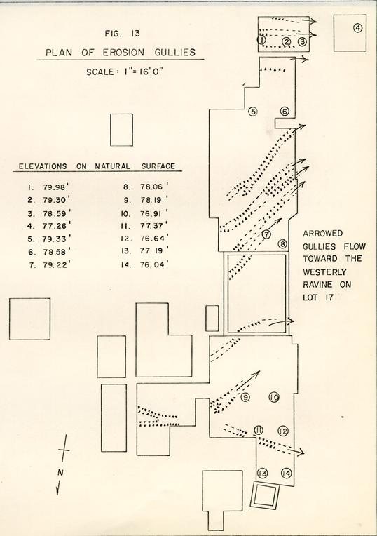 Figure 13 - Plan of Erosion Gullies
ARTIFACT DISTRIBUTION
Complete analysis of the artifactual remains from the site was not undertaken as a part of the 1975 project. However, quantitative distribution of four artifact types was seen as a means of plotting horizontal differentiation in Anderson's shop usage (Figure 14).
Cut Iron
Large quantities of iron bars showing evidence of having been cut (probably while hot) were found everywhere on the site where there was evidence of Anderson's operations. However, the results of the distribution of cut iron is not included on Figure 14. It is interesting that cut iron was not found in the area of Shop "B" which, as previously noted (p.30), had no associated forge and was most likely not used for the working of iron.
Brass Working
While excavating the area south of the modern garage, evidence was found for limited brass working on the site. It comprised copper slag, sprue, and rough castings, as well as a fragment of a graphite crucible, all found in stratigraphic association with Shop "A-2," and pointing to a specialized use for this part of the shop. One may conjecture that it related) to James Anderson's gunsmithing work.
Gunflints
Anderson's position as Public Armourer and the reference of his cleaning and repairing of guns in the Magazine, suggested that the distribution of gunflints on the site might be a means of determining which shop was used for that work. More 83. than half of the gunflints recovered from stratified contexts came from the area of Shop "B" or to the east of it. As was demonstrated earlier (p.31) it seems that Shop "B" was in use until ca. 1779, the year the gun repair activities were moved from Lot 18 to the Anthony Hay shop.
The flint distribution thus suggests that Shop "B" was utilized as a storage and work area for these weapons. However, the nearby association of Shop "A-2" with its brass working activity may indicate functional division of the shops.
Bone Discs
With the exception of a few pieces found in clinker deposits related to Forge "A", evidence for the production of bone button discs was centered at the southern end of the shop complex, a majority associated with Shop "B." These discs consisted of fragments of shoulder bones from which small round pieces had been cut with a carpenter's bit. It is interesting that these discs are often found on military-related sites, though the reason for this is not known.
From the distribution of the remains of this operation, it seems that it was associated with the activities of Shop "B", which, as seen above, was probably used for the cleaning and repairing of guns. As yet, the relationship of the two activities is unknown, and indeed may amount to nothing more than the fact that both activities were performed in the same shop — not necessarily at the same time.
It appears that this button-making activity ceased with the destruction of Shop "B" and the construction of Shop "C" ca.1779. As only negligible quantities of these discs were 84. found in association with Shop "A-2," it seems reasonable to place this activity after the 1777 construction of that building. Thus, a time span of 1777 to 1779 is likely to have been the period in which these discs were being produced on the site.
Problems With Distribution Analysis
As can be seen in Figure 14, almost all the analyzed artifacts were unearthed to the south of the modern garage. Within and to the north of the building, all stratigraphic levels associated with Anderson's shops had been removed or severely disturbed by modern activity, whereas to the south such disturbance was negligible. That fact may have caused the bias in the distribution pattern shown in Figure 14.
CONCLUSION
As with any archaeological project, while some questions are answered many new ones are raised. The 1975 excavations went a long way toward solving many of the original problems concerned with the history of the use of Lot 18, but many questions were only partially answered and others not at all.
As the primary goal of the project was to obtain as much information as possible concerning the James Anderson period of the site's occupation, let us first look at the results of that aspect of the season. It was known from historical sources that Anderson had purchased the lot in 1770, though it was not known when he actually took residence. From the ledgers of brickmason Humphrey Harwood, we learned that between 1777 and 1789 Anderson had ten forges constructed, [questionable assumption] all presumably on Lot 18. The Frenchman's Map shows two long structures abutting the western property line, and they, in all probability, represented the location of Anderson's shops. This was the extent of our knowledge of the site from the historical documentation.
Archaeological investigations on the site in 1931 had confirmed that the long structures shown on the Frenchman's Map were, indeed, shops containing forges. Archaeological knowledge and techniques available at that time precluded the precise dating of features, and thus necessitated further investigation. Without reiterating much of the evidence, the most probable interpretation of the development of the site can be seen in three stages of construction between ca.1770 and ca.1781 [1782] — when the Frenchman's Map was drawn. The first 86. phase consisted of the construction, perhaps by Anderson, of the two small shops associated with external forges. The northernmost of these two shops (the site now covered by the modern garage) is based upon slim evidence so that even its very existence may remain open to question. An addition, marking the second phase, was made to the southern end of this shop in 1777, simultaneously with the construction of two forges within the building. Two years later, the third and final changes were made on the site, with the addition of the northern extension of the original shop and the construction of another to the south. Also at this time, three new forges were added. It is this physical complex, extending for a length of 94'00", which comprised the extent of Anderson's Revolutionary War activities, and is, recognizable as the shop arrangement shown on the Frenchman's Map.
Dating evidence for any of these phases is poor; with such drastic changes taking place in such a short period of time, a relative chronology is the only reliable yardstick. Ceramic artifacts do little to break down this short time period as creamware is the only diagnostic type associated with any of the related features. The disturbances from the 1931 excavations and the 19341940 building of the garage made even relative dating extremely difficult. Confronted, then, with a mass of archaeological data and a weak, but workable, historical framework, the method used to establish the above chronology was to flesh out the frame of the history with the meat of the archaeology.
As far as the architecture is concerned, one would tend to think that due to the rapidity with which the changes were made, the shops would hardly conform to some abstract, formal ideal. Most likely, all of the shops were simple frame structures sitting on top of the brick foundations found during the digging. It is interesting to note that the forges all fell onto the same line. In addition, all the forges within the shop, with the possible exception of Forge "J", appeared to have been worked from two sides, and possibly three. On all the fire boxes it appears that the western side was utilized as a base for the superstructure.
A comparison can be made with the 'nailery' at Monticello. This was a small nailmaking factory erected by Thomas Jefferson in 1793.36 A measured plan of the building, drawn in about 1795, shows the positions of both forges and anvils. Their layout is strikingly similar to that found within Anderson's shops; a geometric arrangement of four anvils equidistant from the corners of each forge, and the forges themselves set in a line.
Our knowledge of forge construction is hardly adequate to understand exactly what Anderson's structures looked like above the ground. This is, in fact, one area where the archaeological research has contributed little. We at least know what the "footprint" looked like, which is certainly a beginning, but how does one build up from this basis′ No photographs, plans, or drawings of forges have been of much help in figuring this out. What we do know is that a forge does not have to be much to be a forge. All that is really needed is a place to build a fire.
88.Another aspect of the story, which archaeology has unfortunately failed to elucidate, is the possibility of manufacturing specialization between the forges and work areas. A look at the immensity of the shops can not fail to cause wonder. Were Anderson's activities really those of the immortal "village smith;" or would we be stretching the point to see, instead, the seed of the nineteenth-century factory in the way the shop is arranged′ Because of the length of the shop, and the variety of tasks Anderson undertook, it would certainly be reasonable to suggest, as a possibility, that each forge had its specific function—- one for gun parts, another for wagon work, yet another for household items, and, of course, one for the shoeing of horses. The distribution analysis discussed on page 82 gives some hint that this hypothesis may be true, but the fact that stratigraphic associations with the forges could only be made in the southern complex leaves this problem partially unresolved.
Turning now to the pre-Anderson period, little need be said, for the most significant findings have been reviewed throughout the report. Little activity took place on the site prior to ca.1755-60. This is borne out by both the historical documentation and the archaeological data, which clearly indicate this lack of activity. Perhaps the only structures on the site prior to the construction of the First Period Kitchen were the shop on Duke of Gloucester Street to the east, which was not investigated in 1975, the smokehouse, and possibly Privy "A." Analysis of the faunal remains suggest that before the occupation of the site by Christiana Campbell 89. (ca.1760-1769), only the bones of wild animals appear on the site (see Appendix 5). After the separation of Lot 18 from Lot 19 in 1760, it seems that the momentum of cultural activity built up to such a point that when, in 1770, Anderson acquired the lot several structures were existing.
The season's excavations, as noted in the Introduction, did not exhaustively cover the site. For the most part, only the area of Anderson's shops and the First Period Kitchen were completely investigated. This certainly leaves a large area for potential discovery of new information which could radically alter any interpretation contained within this report. The entire area of the yard south of the present east/west boardwalk has yet to be checked. One would think that, with the apparent separation of the northern and southern areas of the lot, and the fact that the entrance to the shops was from the east and south, there is a strong likelihood, barring disturbances, for the location of other Anderson related features in this section of the property. The most significant would be the location of a well which almost certainly must have been in existence for use in the shops. One should note that the well beneath the Second Period Kitchen was cut off from the shops by the existence of Fence "C".
Further investigation to the south, towards Francis Street, is still needed in order to locate and determine the nature of the buildings shown there on the Frenchman's Map. Although only a strip approximately 12'0" is available at present for excavation, tests of this area during the 1975 season indicate that modern disturbance may be minimal.
Footnotes
Policy #7578, Mutual Assurance Society, May 20, 1830.
Policy #10995, Mutual Assurance Society, April 24, 1839.
Policy #11111, Mutual Assurance Society, April 14, 1840.
APPENDIX I
| Excavation Register (E.R.) Number | Description of Feature or layer and date of fill. |
|---|---|
| 1910L | Post mold for post hole 1910M, filled with dark ashy loam. (ca.1779) |
| 1910M | Dark loam fill in rectangular post hole, 2'0" x 1'4", located off N/W corner of chimney base. (ca. 1779) |
| 1911F | Hard packed brown loam which overlies mottled yellow clay 1911S. (ca. 1750-60) |
| 1911P | Mixed clay and loam fill of builders trench for west wall of Shop A-3, extending east from wall, 1-½" wide and 1"-2" deep. (ca. 1779) |
| 1912B | Post mold for hole 1912C, abutting the S/W corner of the kitchen. (ca. 1777) |
| 1916B | Circular pit, S/E of Forge "C" with fill of gray loam with clinker lying above lower fill of sandy loam mixed with yellow clay, wood ash and brick chips (1916C). (ca.1800) |
| 1917A | Shallow depression S/W of Forge "D", 2'0" in diameter. (ca. 1800) |
| 1918C | Mixed ash fill of irregular shaped, 2'0" deep hole, cutting through 1918G (ca. 1800) |
| 1918D | Brick and mortar fragments scattered on top of coal ash 1918E, in Forge "D". (ca. 1800) |
| 1918E | Black coal ash in Forge "D", lying below 1918D and above 1918H. (ca.1800) |
| 1918G | Mixed clay fill of circular pit, cut by 1918C (ca.1777-1779) |
| 1918H | Robber trench for walls of Forge "D", filled with brown loam ruble, 5" maximum depth. Extends 0"-2" outside wall line, 4'8" x 6", and of variable width, but no less than 1'5". Partially sealed by 1918E. (ca.1800) |
| 93. | |
| 1981J | Mortar spread at bottom of forge, cut by robber trench 1918H. (ca.1800) |
| 1919C | Mottled gray sandy loam, underlying brick drain. (ca.1770) |
| 1919D | Hole with mottled clay fill and roughly circular, lying below brick drain. (post ca.1750) |
| 1920A | Woodash in pit 1'6" deep and about 2'0" wide, in center of smokehouse. (ca.1775) |
| 1921M | Post hole along northern wall, filled with ash. (ca.1779) |
| 1921T | Spread of brick ruble. (Ca.1775) |
| 1921Z | Post hole, cut by modern landscaping. (ca.1779) |
| 1922T | Gray sandy wash, with a clayey texture. (post ca. 1755) |
| 1923K | Layer of silty sand with brick chips and woodash, 3"-5" thick, below 1923J. (post-1740) |
| 1925E | Brick and mortar scatter, roughly in line with door to reconstructed kitchen (second period). Possibly robbed remains of walkway leading to the building. (ca.1806) |
| 1925H | Gray sandy fill below 1925E and above marl spread 1925J. (ca.1800) |
| 1925J | Spread of marl, a possible walk, or spread around well "A". (ca.1806) |
| 1926D | Yellow mottled clay deposit, in large depression. (ca.1840) |
| 1926M | Dark loam in center of well, associated with rubble. (ca.1840) |
| 1928E | Brick scatter, possible remains of walkway, lining up with 1925E. (post-1815, pre-1830) |
| 1928H | Mixed fill in trench along east side of square. (post-1805) |
| 94. | |
| 1928F | Mixed fill above rotted wooden planks along east side of square. (post-1805, pre-1830) |
| 1928N | Mortar and plaster scatter 3"-4" deep. Found north of anticipated kitchen wall. (post-1782) |
| 1929E | Orange clayey fill, similar to 1929C and also lined with wood. (post-1830) |
| 1931R | Concentration of oyster shell mixed with sandy wash. Lies beneath 1931N and P, and cuts through 1931S, yellow clay. Appears to be fill in erosion trough, 0"-4: thick. (ca.1779) |
| 1933K | Mottled yellow clay with mortar at bottom, possible robbed wall trench. Only a small section remains. (post-1782) |
| 1933L | Mottled yellow clay, very similar to 1933K, with mortar at bottom, but located in south balk. (post-1782) |
| 1937J | Layer of yellow clay with flecks of clinker intermixed. Varies from 5" thick at north to lensing out 1'0" from south end of square. Lies beneath coal clinker level 1937G and is probably associated with similar clay layers found in other squares. (ca.1775) |
| 1939K | Plaster concentration along north end of square, same as 1949E. (ca. 1775) |
| 1940 | Well located along western edge of 1929. (ca.1929-30) |
| 1944G | Dark brown loam, C.W. fill, of trench along south side of forge, replaces possible robber trench, 1'6" deep, 1'0" wide. (modern) |
| 1944Z | Robber trench for west wall of Shop "C". Rubble mixed fill, brickbats and mortar lumps. (ca.1800) |
| 1945G | Large hole 2'3" x 4'5" located along north side of square. Mixed loamy fill with brickbats, mortar and shells. (post-1810) |
| 1945H | Layer of brown loam with brick chips and mortar, about 6" thick and cut by 1945C, F, & G. (post-1782) |
| 95. | |
| 1945N | Loamed filled large rectangular hole below mixed clay 1945M, 2'0" x 3'0" x 10" deep. (post-1770) |
| 1945S | Layer of brown sandy loam covering entire square, 2"-4" thick, and cut by 1945N and R. (post-1770) |
| 1945T | Sandy brown loam in large rectangular hole adjacent to E.R.1929. Southwest corner unexcavated. Same as 1949D, entire hole measures 5'4" x 3'0" x 1'3" deep. (post-1770) |
| 1946Y | Mottled clay fill of post hole with squarish shape, 1'10", 9" deep. (ca.1779) |
| 1946Z | Gray sandy ash fill in northwest corner of square, below 1946W. It slopes into ravine with a 1'-2' thickness. (post-1750) |
| 1947E | 8" x 1'7" area of mottled yellow clay, with mortar lumps. Possible robbed wall trench for kitchen, same as 1933K and L. (post-1782) |
| 1949E | Plaster concentration same as 1939K, lies beneath 1949D and above 1949F. Varies in thickness to 5", containing grayish plaster with shell bits. (ca.1775) |
| 1957G | Post hole with mixed loam fill, same as 1921M, is 2'0" x 1'3" x 1'4" deep. (ca.1770) |
| 1957K | Yellow clay layer with brick chips and woodash, lensing out two feet into area, depth to 3". Same as 1921R. (ca.1775) |
| 1957L | Layer of brick and mortar rubble, 5"-7" thick, and sealed by 1957K. Same as 1921T. (ca.1775) |
| 1958C | Post hole (mold 1958B) 1'6" x 1'7" x 1'2" deep located adjacent to west wall, underlying it. Cut by hole 1958G. (ca.1760) |
| 1958G | Mixed clay and loam fill in rectangular hole beneath west wall of Shop "A-3." (post-ca.1770) |
| 1962A | Post hole beneath west wall of kitchen, 1'5" x 1'10" x 1'10" deep, filled with mixed loam with soft orange colored bricks. (post-ca.1740, pre-ca.1760) |
| 96. | |
| 1963C | Lense of coal ash and clinker beneath Forge "E", lying above 1963E. 1"-6" thick increasing to north and is found only beneath the north wall of Forge "E". (post-1770-ca.1777) |
| 1963D | Brown loam in 1-½" wide cut between north wall of Shop "A-3," and fill beneath Forge "E". Cuts through 1963C and E. Possibly remains of builders' fill associated with construction of north wall. (ca.1779) |
| 1963F | Layer of crumbly yellow mixed clay beneath Forge "E" foundation, containing large quantity of Miocene shell. 4"-5" thick, this clay appears to lense out, or is cut into, by clinker. Cut by 1963C and E. (ca.1779) |
| 1963G | Layer of gray ash with mixture of brown and red ashes, predominantly domestic. Layer is 4"-5" thick, below 1963F and overlying 1963L. This layer is probably related to thick deposits of ash and sand found north of the forge, though exact correlation is difficult due to disturbance and similarity of these layers. (ca.1777-79) |
| 1963H | Small hole (2" x 1'-½" oval) filled with rotted wood fibers surrounded by sheathing of sheet iron or tin - several nails in situ. This hole cuts through the brick on the north side of the forge (A) foundation. Possibly support for bellows or crane for heavy pieces. (post-1770-ca.1777) |
| 1963J | Dark gray woodash below 1963G and surrounding Forge "A" on north and west sides. Possible working level for the forge, 1"-2" thick. (post-1770-ca.1777) |
| 1963N | Layer of brown loam with brick chips and mortar flecks, 4"-5" thick. (ca.1750-[cut-off]) |
| 1966A | Layer of brown loam with brick flecks below 1965S, cut by 1965V, W,X, and X. (post-1770) |
| 1969B | Fairly shallow almost circular hole, filled with brown loam, much iron fragments and ash. 1'10" x 1'6" x 8" deep. (ca.1800) |
| 97. | |
| 1969J | Robber trench of north wall of Shop "C", containing loam mixed with slight amount of mortar, but with much bone button making debris. (ca.1779) |
| 1970B | Robber trench running N/S, ending at the south wall of Shop "C" and running south into the balk. (ca.1800) |
| 1970C | Robber trench running N/S, lying north of the south wall of Shop "C", slightly askew line of 1970B. (ca.1800) |
| 1970S | Round hole with sloping sides, 2'1" x 1'10" x 4" deep, lying below 1969G, and has same fill as 1969G, dirty gray loam. (ca.1800) |
| 1970Z | Gray sandy loam beneath 1970W arbitrary 2" level removed separately as appeared to have objects trampled into surface. 1970Z covers entire square and is 3" to 6" deep increasing to west. (ca.1760-70) |
| 1971J | Layer of ash and clinker extending into north balk. Appears to be in two or more depressions or cuttings, one running NNW/SSE. Deliberate dump for debris′ Under 1971H and badly cut by 1944Z, robber trench. (post-1770-ca.1777) |
| 1971S | Gray sandy loam no more than 2" thick, lying below 1971E. As thin, may have had later objects worked into its matrix. (ca.1760-ca.1777) |
| 1972A | Trench (robber′) with mixed loam fill no different from 1973A and B, but may cut them. Extend EW across both E.R.1972 and E.R.1973. 11" max. wide 9" deep. (ca.1800) |
| 1972B | Sub-rectangular deep pit, mixed clayey loam fill with many brickbats. Numerous iron objects. West side ends in step, right side continues as deep square. Possible small well′ Abuts presumed west edge of forge length 2'9" overall, 1'11" to ledge, width 2'0". (ca.1770-77) |
| 1972C | Half round shallow pit - rest destroyed by B.W. charcoal and loam fill. A pair with 1917A. Anvil seatings. 1'7" across NS; 9" EW remaining, 7" depth remaining. (ca.1800) |
| 98. | |
| 1972X | Post hole cutting 1972V, and 1972Z. 1' x 1'5" x 1'5", clayey fill. No datable artifacts. (ca.1760) |
| 1973A | Mixed loam below C.W. in forge area, in E.R.1973 extending into E.R.1972. Lies above forge rubble and charcoal layer. North of 1972A. 1" thick. (ca.1800) |
| 1973C | Post hole fill same as 1973A/B, in 1973B. Cuts charcoal. 9" x 1'3" x 1'9" (max.). Perhaps tow bottoms. (ca.1800) |
| 1973D | Post hole, brown loam fill same 1973A/B. Cuts charcoal. 11" x 1'7" x 1'10" deep. (ca.1800) |
| 1973E | Post mold at bottom of 1973D. Darker loamy fill. 7" diam. 7" deeper than 1973D. (ca.1779) |
| 1973F | Post hole, same 1973A/B [where listed′] type fill, under it, cuts charcoal, 9" x 9" x 1'0" max. depth. (ca.1800) |
| 1973G | Post hole larger than rest of group, but shallow, 1'7" x 1'3" x 6", same fill. (ca.1800) |
| 1973H | Post mold at bottom of 1973G, somewhat darker fill. 11" diam., 1'2" deep. (ca.1800) |
| 1973K | Forge rubble c.3" thick has some clinker but mixed. (ca.1779-ca.1800) |
| 1973M | Pit - round hole gray loam w/ash. 1'5" x 1'9" x 7", another "anvil seat." Difficult to find edges, cuts ash, under 1973B. (ca.1800) |
| 1973N | [where is 1973B′] Robber trench for east wall of Shop "A-2". Brown loam and rubble fill, 1'3" wide, c.4" deep. Under CW. Appears to be cut by E.R.1972A -3s R.T. (ca.1800) |
| 1973P | Ash spread, "working surface" around forges, under 1973A. 2" max. depth. (ca.1779-ca.1800) |
| 1973S | Top fill of large round pit, ashy mixed fill. 3'2" x 3'0" x 10". Result of robbing the feature. Cut by E.R.1973M. (ca.1779) |
| 99. | |
| 1973W | Yellow clay mixed fill of post hole 1'7" x 1'3" x 2'3" with a ledge 3" wide, 4" from bottom on north side. Cut through gray sandy loam cut by pit 1973V, and below Forge "D". (ca.1770-77) |
| 1974B | Robber trench filled with much ash and slag, south wall. (ca.1800) |
| 1975C | "Iron Dump" layer below E.R.1975A and wall E.R.1975D above gray sandy, 1" to 6" in depth. Undulating surface, little soil, fill mostly iron objects. (ca.1779) |
| 1975H | Post hole, square hole, 1'6" x 1'2", 1'10" deep, southernmost of 3 aligned holes. (post-ca.1779) |
| 1975M | Post hole 1'6" x 1'8" and 1'7" deep, northernmost of holes on 4'6" center. (post-ca.1779) |
| 1975R | Round hole, "anvil" pit, mixed dark fill ash and loam, under 1975A. 1'4" x 1'6" x 8-1/2" deep. (ca.1800) |
| 1975S | Oval hole, "anvil setting," 1'10" x 1'6" x 6", very mixed fill, mortar lumps. (ca.1800) |
| 1975V | Mottled clay and loam fill of "slot" about 1'3" wide, 5" deep, under ash 1975T. (ca.1777-ca.1800) |
| 1975W | Small patch of dark soil cut by robber trench, east wall of Shop "B". (post-1770-ca.1777) |
| 1975X | Same as 1975W, but at southeast corner of east wall of Shop "B". (post-1770-ca.1777) |
| 1975Y | Gray loam with much ash, bottom fill of slot, 5" deep, whole slot 1'1" wide, 10" deep below 1975V in slot. Extends east to form a "T" junction. Drain′ Large iron bar 2'2" x 2" lies across in top of fill to east, possible location of robbed one. (ca.1777-1800) |
| 1975Z | Robber trench, upper fill dirty gray sandy loam with mortar lumps and brick chips, getting heavier concentration of mortar and brickbats at bottom, above G.S.L. cuts 1975W and X. (ca.1777) |
| 100. | |
| 1977F | Clinker spread east of N/S wall, 1" max. depth. Post dates construction of wall, lies beneath 1977A. (ca.1779-ca.1800) |
| 1977J | Square post hole with no sign of mold. Mixed loamy fill. 1'8" x 1'8-1/2" x 1'9" deep. Cut by 1977H. (post-ca.1779) |
| 1981C | Hole filled with brick rubble 1'6" x 1'4" x 11" deep, total depth 2'4". (ca.1770-ca.1777) |
| 1981K | ′Cesspit filled with gray sticky loam with some lumps of clay, lying above lower fill 1981L. (ca.1760-70) |
| 1985B | Mixed loam in semi (′) circular depression, sealed by clay 1972V 2'6" entant x 3'3" x 6" deep. ′Crude cesspit. (ca.1750) |
| 1985C | Post hole cut by 1972V, matching 1972X, with a mixed clay fill. 1'2" x 8" extant x 8" deep. (ca.1760) |
APPENDIX II
THE HUMAN SKELETONS
by
Leonard E. Winter
Investigations were undertaken to establish the individual sex, race, age and stature of two human skeletons exposed in square E.R.1942-10.G. Located in northern and southern parallel graves facially oriented on the east-west axis, the skeletons were respectively designated features E.R.1942K-10.G and E.R.1942L-10.G (see Figure 17).
Several factors influenced the excavation and subsequent laboratory analysis of the skeletons. Foremost was the necessity to maintain project secrecy. In Williamsburg, where site excavation meets the scrutiny of both tourist and fellow employee, the ability to withhold any shred of archaeological information becomes increasingly difficult with each passing day. To subsequently escape publicity and the repercussions therein, the excavation, collection of data, and backfilling of the burials was hastened before casual rumor became documented fact. While stressed urgency might have necessitated slipshod technique, excavators quickly exposed the remains with the utmost competency.
Grave fill in square E.R.1942-10.G was first noted on July 3, 1975, yet due to intermittent rains, burial exposure was delayed until November 5 of that same year. In this period of four months, great amounts of water were retained in the level of the burials forcing workmen to initially toil in unfavorable conditions. After several days of pumping, E.R.1942L10.G was sufficiently drained and dried, permitting complete 102. skeletal exposure. However, E.R.1942K-10.G, some six inches deeper, remained flooded throughout the course of excavation yielding little in the way of substantial information.
Saturated conditions in the square also effected pronounced bone porosity in both burials. While this fragility of bone made complete skeletal removal inadvisable, the absence of refined osteometric tools in the laboratory made such an endeavor impractical. Subsequently, only the skull from E.R.1942L-10.G was removed to the laboratory for closer examination.
SKELETON E.R.1942L-10.G, SEX (FIG.18)
On November 5, 1975, work was commenced in removing fill from the northernmost burial trench, E.R.1942L-10.G. In the process, the remains of a hexagonal coffin were delineated. From the extant configuration, it was assumed that the body had been interred with facial orientation to the east. Subsequently, fill removal was intensified at the western end of the coffin so the skull could be quickly exposed for analysis.
Osteologically, the skull yields fairly reliable information in the determination of sex. Based on the initial assumption that the average male is more robust than the average female, it is further assumed that all male cranial processes for the attachment of musculature will display a more rugged character. Two sexually diagnostic regions of the cranium are the mastoid processes (occurring bilaterally) and the external occipital protuberance.
The mastoid process, located behind the external auditory meatus (ear canal) on the temporal bone, serves as the insertion base for the sterno-cleido-mastoid muscle of the neck. Conical 103. in shape (viewed anteriorly), it is generally wider (viewed laterally) with deeper vertical projection in the male. Even without metric confirmation, the left mastoid process of E.R.1942L-10.G exhibited a rugosity strongly indicative of male physiognomy.
The external occipital protuberance, located on the squamous portion of the occipital bone, is a bulbous prominence for the attachment of the nuchal ligament. It is generally larger with greater horizontal projection in the male. All features on the occipital bone of E.R.1942L-10.G, including the external occipital protuberance and the inferior nuchal line, clearly demonstrated marked robusticity reinforcing the male sex determination.
Once the skeleton was completely exposed, additional regions were checked for corroborating sexual data. The general size of all long bones and the configuration of the pelvis confirmed that ER.1942L-10.G was an adult male.
E.R.1942L-10.G, RACE
From the outset, the assessment of race proved to be of major interpretive interest.
To facilitate diagnosis, the skull was removed to the laboratory for additional cleaning. Once completely exposed, the anterior aspect of the skull was observed to have undergone no major alteration from earth pressure, thus minimizing significant interpretive error. The face, which demonstrated a true narrow configuration, did not conform to Negroid dimensions. Similarly, the frontal bone did not exhibit any degree of recession, a feature which occurs quite frequently among Negroes. 104. The most important factor to repudiate the initial assumption that this was a Negro interment involved the absence of alveolar prognathism. Due to the lack of this most characteristic Negroid trait, it was necessary to conclude that E.R.1942L-10.G was the remains of an adult Caucasian male.
E.R.1942L-10.G, AGE
The assessment of individual age was determined from observations of dentition, epiphyseal union, and sutural obliteration.
Full permanent dentition was present in E.R.1942L-10.G, indicating a minimum individual age of 21 years at death. Observations of molar occlusal attrition provided an additional measure of age. By comparing the character of molar grinding surfaces with charts compiled by Brothwell,1 the dentition of E.R.1942L-10.G was suggestive of a range between 25 and 35 years of age.
Epiphyseal union involves the full closure of bones of the post-cranial skeleton. By noting the complete ossification of certain bones, it is similarly possible to assign a minimum of individual age for such physiological involvement. All extant bone in E.R.1942L-10.G when compared with closure schemes posited by Genoves,2 was indicative of an age range in excess of 25 years.
105.The last means of assessing age, sutural obliteration, has long been of controversy among osteologists. Like epiphyseal union, the scheme involves the closure at margins but refers only to those bones of the skull. Opponents of the technique maintain that marked cranial variation obviates any attempt to temporally classify material. Still others maintain that variation does not discount the viability of the technique as a general base. In support of the latter argument, cranial development in E.R.1942L-10.G exhibited no major variation. Diagnostic divisions of the coronal and sagittal sutures indicated a minimum individual age of 30 years.
By calculating an average from the above observations, we may estimate that the individual died at age 27.
E.R.1942L-10.G, STATURE
The living stature of an individual can be attained by applying certain long bones measurements to calculations posited by Trotter and Gleser.3 The equations, based on mathematical regression formulae, provide for distinction of both race and sex. Assuming that E.R.1942L-10.G was the remains of an adult white male, the following statural estimates were reached:
- 1) 1.26 (Max. length, cm., FEMUR + Max. length, cm., TIBIA)
+67.09 = STATURE
- 1.26 (48.4 + 38.1) + 67.09 = S
- 1.26 (86.5) + 67.09 = S
- 108.99 + 67.09 = S
- 176.08 + S
- 106.
- 2)2.32 (Max. length, cm., FEMUR) + 65.53 = S
- 2.32 (48.4) + 65.53 = S
- 112.28 + 65.53 = S
- 177.8 = S
These statural estimates when converted and averaged indicate a height approaching six feet. From the general size of all long bones, viz., femora and tibiae, we may further conclude that this individual possessed a massive weight to complement his stature.
E.R.1942L-10.G, PATHOLOGY
Pathological conditions in E.R.1942L-10.G were confined to the teeth. Both the upper and lower dentition were offset by slight alveolar resorption. This condition, indicative of periodontal disease, was most likely caused by the extensive deposition of calculus still active up to death.
The upper dentition demonstrated an interesting array of anomalies. In addition to an advanced occlusal caries of the right first molar, the left third molar exhibited impaction and the anterior teeth had rotated clockwise as a result of palatal crowding. The ante-mortem loss of both second premolars suggests the possibility of therapeutic removal for the provision of additional dental space. Whatever actions transpired before death, the condition of the mouth was most assuredly the cause of great physical pain.
The absence of certain pathological conditions reinforced the assessment of age. None of the vertebrae demonstrated any degree of osteophytosis. This process of intervertebral lipping accompanies the degenerative effects of age and arthritis. Clinically, arthritis first begins to complicate the vertebral 107. column at age 30. With no such conditions having been observed in E.R.1942L-10.G, the pre-30 age assessment thus seems entirely plausible.
There were no osteological indicators to explain the cause of death of the individual. From statural observations noted earlier, it might be possible to infer death was caused by physiological exertion leading to mio-cardial infarction. Historically, however, diseases and dysfunctions of the heart are conditions of technological man and seemingly did not plague our Colonial American predecessors. From extant medical accounts of Virginia in the eighteenth and nineteenth centuries, it is probable that death was incurred at the hand of one or more recurring diseases. Furthermore, these pathogenic diseases would leave no trace effects on the skeletal material.
E.R.1942L-10.G, BURIAL POSTURE
A major problem in the interpretation of E.R.1942L-10.G involved the posture of the skeleton. The displacement of some bone was initially suggestive of activity associated with secondary reburial. (see Figure 18)
Historically, there were two modes of secondary reburial. The first method entailed the exhumation and subsequent relocation of an intact coffin. The second procedure involved the removal of bone from an unstable or decomposed coffin with direct transfer back into the ground or replacement in a new coffin.
Albeit spatially disordered, all bones in E.R.1942L-10.G were located in the correct relative position. Unless the grave digger relegated to exhuming the original burial proceeded to extricate and relocate each bone separately in the new coffin, 108. collation is doubtful. This unlikely possibility thus obviates consideration of the latter proposal.
The first mode of secondary reburial, i.e., the exhumation and subsequent relocation of an intact coffin, similarly does not sufficiently explain the displacement of bone. The position of the vertebrae and bones of the left leg are suggestive of relocation during some aspect of coffin movement. Yet any movement sufficient to shift Vertebrae and the formidable bones of the lower leg should similarly have played havoc with the original position of all bones. The simple fact that no other bones exhibit relocation, especially the gracile bones of the left lower arm, repudiates the claim of secondary reburial.
Discounting secondary reburial, it becomes necessary to examine causative factors of bone displacement associated with primary inhumation. The majority of data, notwithstanding the activities of earth pressure or burrowing animals, suggests that the relocation of bone in E.R.1942L-10.-G was effected by induced burial posture.
The foot end of the coffin measured 9-1/2" in width. This limitation in space, regarding the statural robusticity of the individual, would have prevented the normal parallel extension of the legs. The angle of the left tibia and fibula, and the fact that only the proximal ends of these bones are located beneath the right leg, strongly suggests that the left leg was flexed behind the right knee. The left downward angulation of the pelvis, as illustrated in the burial, would be the physiological concomitant of such directional leg flexion. Furthermore, the placement of vertebrae exhibiting both primary and secondary curves would similarly result from such pelvic angulation 109. The separation of the left femur from the left tibia and fibula is probably indicative of shift accompanying decomposition. To flex at the knees in the noted manner would probably entail raising the left side of the pelvis. Decomposition, first occurring at the knees, would result in disarticulation. With this subsequent reduction in the length of the leg, the pelvis could have been impelled to relocate in the prone position carrying the still articulated femur. Once the pelvis had come to rest, the femoral-acetabulum articulation would decompose, leaving the femur at its present illustrated location.
E.R.1942L-10.G, SUMMARY
E.R.1942L-10.G was the remains of a tall, robust, white male approaching 30 years of age. While pathological evidence did not explain the cause of death, we may assume that disease, a frequent visitor to the eighteenth and nineteenth century urban environments, was the culprit.
E.R.1942K-10.G, GENERAL OBSERVATIONS
The potential for information retrieval from E.R.1942K-10.G was extremely poor. Standing water in the burial trench was never sufficiently removed to permit skeletal exposure. In an attempt to gather basic data, fill from the westernmost third of the burial trench was removed. Bones located and extricated by hand provided a superficial interpretive reconstruction. Eleven fragments of bone (7 cranial, 4 post-cranial) and nine teeth were recovered from the burial trench. Of the seven cranial fragments, only the petrous portion of the left temporal bone provided useful data. The size of the external auditory 110. meatus and the mastoid process suggested that the remains were either those of a sub-adult or adult female.
Three cervical vertebrae and a portion of clavicle represented the post-cranial material. The gracile character of these bones similarly reinforced the above analysis.
All nine teeth retrieved from the burial trench were permanent forms precluding the possibility that the remains were other than adult. The character of three incisors substantiated a female sex determination.
The presence of two third molars indicated a minimum individual age of 21 years. From the lack of demonstrable molar attrition, and age much in excess of 21 years seems very unlikely.
Important information was lost from the inability to completely expose the skeleton. Although statural estimates are best achieved through the measurement of long bones, relative statements on size can still be posited. From the antero-posterior breadth of the clavicle, it is highly probable that this adult female possessed a very slight stature.
Like E.R.1942L-10.G, this skeleton did not exhibit conditions indicative of the cause of death. Similarly considering the age of the individual, death was probably induced by some disease.
BURIAL PLOT INTERPRETATION
The fact that graves E.R.1942K-10.G and E.R.1942L-10.G are closely grouped with both coffin sides and ends demonstrating parallel placement, suggests contemporary interment. Due to rigid cultural standards in the eighteenth and nineteenth centuries 111. the contemporary interment of an adult male and female in the same plot would most assuredly indicate racial homogeneity.
If the features were not contemporary, the proximity of the graves at least suggests that persons involved in the interment of one individual were cognizant of the other burial location. Due to the previously mentioned racial values operative at the time, it seems highly unlikely that a white individual would have been buried next to the grave of an unknown or forgotten person of possible black origin. This same standard would have been incurred for the burial of a Negro next to the remains of a possible white individual.
If we are to conclude that racial homogeneity was maintained in burials E.R.1942L-10.G and E.R.1942K-10.G, then the positive racial identification of the former burial would infer the same determination for the tenuous remains of the latter. Subsequently, it must be inferred from this line of reasoning that E.R.1942K10.G was the remains of an adult white female.
From the placement of the graves and the respective race, sex, and age of the individuals, an assessment of a marital or sibling relationship seems likely if the interments were contemporary or nearly so. If some span of years separated the burials, it would be suggestive of interment in a generational family plot. Since only a very small portion of Archaeological Area G was excavated, restraints on this inference must be maintained until that time when additional burials are located and the skeletal material is analyzed for specific genetic comparability.
DATING EVIDENCE (by Eric Klingelhofer)
The stratigraphic record for square E.R.1942 shows that the graves E.R.1942K and L both cut through the same layers and were sealed by the same layer, implying that a relatively brief period of time separated the interments. Both were coffin burials, with a large number of nails used in their construction. No coffin fittings, however, were recovered.
The date of the burials is difficult to pinpoint. The graves cut through a layer containing artifacts dating no earlier than 1820. Among the nails used in the coffins were some which had been cut, a process not common until the first decades of the nineteenth century. Furthermore, although there were no late ceramic finds in the grave fill, a wooden button found in E.R.1942L-10.G was of a type (four or five hole) which has been assumed to be "a sign of nineteenth century content."4 The graves should be no earlier than ca.1820, and in the absence of any definitely later objects, may be assumed to be earlier than, say 1840. Thus, a date of interment ca.1830 is reasonable.
APPENDIX III
| E.R.# | Cond. or Shape | Meas. | Color | Mortar |
|---|---|---|---|---|
| E.R.1909A | ||||
| Cut trench | Whole | 7-½ x3-5/8x 1-7/8 | Dk. red | None |
| E.R.1911J | ||||
| Post hole | Complete well brick | 8-5/8x4-¼x2-¼x2-3/8 | Dk. red | None |
| E.R.1913N | ||||
| Clay 'dump' | Whole | 8-¾x4-5/8x2-7/8 | Lt. Orange | |
| E.R.1915P | ||||
| Forge C | Whole | 8-¼x3-¾x2-7/8 | Dk. red | Fine-shell buff |
| E.R.1918K | ||||
| Forge D | Complete | 8-7/8x3-¾x2-¾ | Dk. red | None |
| E.R.1919 | (2) Whole | 8-3/8x3-7/8x2/58 | Salmon | Soft-buff shell large fragments of shell-charcoal |
| E.R.1919B | ||||
| Layer over Drain | Whole | 8-¼x3-7/8x2-5/8 | Burnt Orange | None |
| E.R.1920B | ||||
| Floor of Smokehouse | Broken | 5-1/8x4-3/8x2-5/8 | Salmon | None |
| E.R.1921T | ||||
| Brick rubble | Whole | 8-7/8x3-¾x2-5/8 | Lt. Salmon | None |
| E.R.1922 | Broken rubbed | 6-3/8x4-¾x5"x3-1/8" Hgt. | Dk. red | None |
| E.R.1922A | Broken | 3-5/8x3-½x2-¼ | Dk. red | None |
| CW trench | modern | |||
| E.R.1922N | ||||
| Clay deposit | Whole | 8-5/8x3-½ 22-½ | Salmon | None |
| E.R.# | Cond. or Shape | Meas. | Color | Mortar |
|---|---|---|---|---|
| E.R.1922T | ||||
| Wash layer | Broken | 4-5/8x3-5/8x2-¼ | Purple | None |
| E.R.1923A | ||||
| Fill of catch basin | Broken | 6-5/8x3-7/8x2-5/8 | Lt. Salmon | None |
| E.R.1923B | ||||
| Fill of Drain | Whole | 9-¼x4-¼x2-3/8 | Pink-red | Medium buff-shell charcoal |
| E.R.1923B | ||||
| Fill of Drain | Whole | 7-7/8x3-½x2-7/8 | Purple | Coarse medium shell with charcoal |
| E.R.1926F | ||||
| Well A | Whole | 8-1/8x3-¾-2-¾ | Dk. red | Sandy yellow shell |
| E.R.1926F | ||||
| Well A | Fragment | Dk. red | Hard buff shell | |
| E.R.1926F | ||||
| Well A | Broken | ′x3-7/8x2-5/8 | Salmon | Hard buff shell |
| E.R.1926F | ||||
| Well A | Whole | 8-¾x4x2-¾ | Salmon | Hard dark buff shell |
| E.R.1926F | ||||
| Well A | Whole | 9-¼x4-1/6x2-½ | Salmon | |
| E.R.1926F | ||||
| Well A | Whole-well brick | 8x3-3/8x4-5/8x2-3/8 | Dk. Salmon | Hard buff shell |
| E.R.1926F | ||||
| Well A | Broken | ′x3-7/8x1-7/8 | Dk. red | None |
| E.R.1928 | Whole marked "Portsmouth Brick" | 8-7/8x3-5/8x3-1/8 | Dk. red | None |
| E.R.1931D | ||||
| Disturbed | Broken | 5-¾x3-¼x2 | Purple | None |
| E.R.1931M | ||||
| Walkway A | Whole | 8-5/8x4-1/8x2-5/8 | Lt. Salmon | Fine buff shell |
| E.R.1931M | ||||
| Walkway A | Whole | 8-7/8x4-1/8x2-5/8 | Lt. Salmon | Fine buff shell |
| E.R.1941 | Broken | 7x4x2-3/8 | Burnt Orange | None |
| E.R.# | Cond. or Shape | Meas. | Color | Mortar |
|---|---|---|---|---|
| E.R.1944 | ||||
| Whole | 8-¼x3-¾x2-5/8 | Dk. red | Fine shell buff | |
| E.R.1949P | ||||
| Fill of Gully | Broken | 4-3/8x4-1/8x2 | Orange | None |
| E.R.1954C | ||||
| Rubble | Broken | ′x4-¼x3 | Lt. Orange | |
| E.R.1954C | ||||
| Rubble | Broken | ′x4-¼x3 | Buff | |
| E.R.1958H | ||||
| W.Wall, Shop A-3 | Whole | 8-¼x3-½x2-½ | Dk. red | Soft buff |
| E.R.1958H | ||||
| W.Wall, Shop A-3 | Whole | 8-¼x4-3/8x2-3/8 | Dk. red | Soft deep |
| E.R.1961B | ||||
| Drain Catch Basin | Broken | ′x3-7/8x 1-1/8 | Dk. red | Hard buff shell |
| E.R.1961B | ||||
| Drain Catch Basin | Whole | 8x3-5/8x2-5/8 | Dk. red | Hard buff shell |
| E.R.1961B | ||||
| Drain Catch Basin | Whole | 7-7/8x3-3/8x2-5/8 | Dk. red | Hard buff shell |
| E.R.1961B | ||||
| Drain Catch Basin | Whole | 8-¼x2-7/8x1-½ | Dk. red | Dark buff shell |
| E.R.1961B | ||||
| Drain Catch Basin | Whole | 8-1/8x3-7/8x2-¾ | Salmon | Lt. buff hard shell |
| E.R.1961C | ||||
| Kitchen Chimney | Whole | 9-3/8x4-¼x2-¾ | Salmon | Hard buff fine shell |
| E.R.1962B | Whole | 9-1/8x4-1/8x2-¾ | Orange | Dark buff shell |
| E.R.1963B | ||||
| Forge E | Whole | 8-7/8x3-7/8x2-7/8 | Med. red | Buff shell soft |
| E.R.1963B | ||||
| Forge E | Whole | 8-¼x3-3/8x2-½ | Orange | Lt. yellow shell |
| E.R.1963B | ||||
| Forge E | Whole | 8-1/8x3-¾x2-¾ | Orange | Hard white shell |
| E.R.1963B | ||||
| Forge E | Whole | 8-7/8x4-1/8x2-½ | Salmon | Hard white shell with brick flecks |
| E.R.1963B | ||||
| Forge E | Whole | 8-¼x3-7/8x2-3/8 | Med. red | None |
| E.R.# | Cond. or Shape | Meas. | Color | Mortar |
|---|---|---|---|---|
| E.R.1967D | ||||
| Post Hole | Whole | 8-5/8x3-¾x2-5/8 | Dk. red | |
| E.R.1967F | ||||
| ′Robber Trench | Broken | ′x4-1/8x2-¾ | Lt. Orange | |
| E.R.1968B | ||||
| Post Hole, Line 'A' | Fragment | ′x3-½x2-¾ | Lt. Orange | |
| E.R.1969J | ||||
| N. Wall, Shop B | Broken | ′x3-¾x2-½ | Dk. red | |
| E.R.1970C | ||||
| W. Wall, Shop B | Broken | ′x3-¾x2-¾ | Dk. red | |
| E.R.1970X | ||||
| S. Wall, Shop B | Whole | 8-½x3-7/8x2-¾ | Red | Lt. yellow shell |
| E.R.1971L | ||||
| W. Wall, Shop C | Whole | 8-5/8x4x2-½ | Burnt Orange | |
| E.R.1971M | ||||
| Forge B | Whole | 8-½x3-7/8x2-½ | Orange | |
| E.R.1971N | ||||
| Forge G | Whole | 8-3/8x4x2-½ | Dk. red | |
| E.R.1972R | ||||
| Forge J | Whole | 8-½x3-¾x2-5/8 | Red | Buff to gray shell |
| E.R.1972R | ||||
| Forge J | Whole | 8-½x3-7/8x2-5/8 | Dk. red | |
| E.R.1975E | ||||
| E. Wall, Shop C | Whole | 8-3/8x3-7/8x2-5/8 | Dk. red | |
| E.R.1975Z | ||||
| E. Wall, Shop B | Broken | 2x3-¾x2-½ | Burnt Orange | |
| E.R.1976D | ||||
| Walkway B | Fragment | ′x3-7/8x2-7/8 | Dk. red | |
| E.R.1976D | ||||
| Walkway B | Fragment | ′x4x2-5/8 | Dk. red | Buff shell with charcoal |
| E.R.1976D | ||||
| Walkway B | Fragment | ′x3-7/8x2-/38 | Dk. red | |
| E.R.1977C | ||||
| E. Wall, Shop C | Whole | 8-½x3-7/8x2-½ | Dk. red |
APPENDIX IV
| E.R.# | TYPE | COLOR | TEXTURE | NOTATION |
|---|---|---|---|---|
| 1910V | Hard shell mortar | Light buff | Large shell | |
| 1910Y | Hard shell mortar | Dark buff | Small shell | Lath marks |
| 1912S | Hard shell mortar | Dark buff | Large shell | |
| 1915P | hard shell mortar | Dark buff | Small shell | |
| 1918D | Hard shell mortar | Buff | Small shell | |
| 1918H | Hard shell | Buff | Large shell | |
| 1921B | Hard shell plaster | Dark buff | Medium shell | White washed |
| 1921K | Soft shell mortar | Light buff | Fine shell | Burned |
| 1921R | Hard shell mortar | Light buff | Large shell | With ash |
| 1921R | Soft shell plaster | Buff | Fine shell | White washed |
| 1921R | Large clump of mortar with several brick bats 16" x 12" x 7½", large fragments of charred wood coarse with large & small shell, buff to dark buff. | |||
| 1921S | Hard shell mortar | Buff | Fine shell | Burned |
| 1921T | Hard shell plaster | Dark buff | Fine shell | White washed |
| 1921W | Hard shell plaster | Light buff | Fine shell | White washed |
| 1921X | Hard shell mortar | Dark buff | Medium shell | With ash |
| 1922A | Hard shell mortar | Dark buff | Medium shell | |
| 1922G | Hard shell plaster | Dark buff | Fine shell | White washed |
| 1922J | Hard shell plaster | Buff | Fine shell | White washed lath |
| 1922P | Hard shell plaster | Dark buff | Large shell | White washed |
| 1922R | Hard shell plaster | Light buff | Fine shell | White washed lath |
| 1922T | Hard shell plaster | Buff | Fine shell | White washed lath |
| 1922T | Hard shell mortar | Light buff | Large shell |
| E.R.# | TYPE | COLOR | TEXTURE | NOTATION |
|---|---|---|---|---|
| 1922Y | Soft shell mortar | Light gray | Fine shell | With ash |
| 1923A | Soft shell mortar | Buff | Medium shell | |
| 1923B | Soft shell mortar | Buff | Fine shell | |
| 1923E | Soft shell mortar | Buff | Fine shell | |
| 1923G | Soft shell mortar | Buff | Fine shell | Poor sample |
| 1923G | Soft shell mortar | Gray | Large shell | With ash |
| 1923G | Soft shell mortar | Dark buff | Fine shell | |
| 1926F | Soft shell mortar | Buff | Medium shell | |
| 1927B | Hard shell mortar | Dark buff | Fine shell | Bog iron Flex's |
| 1928N | Hard shell plaster | Dark buff | Fine shell | With ash |
| 1928N | Hard shell mortar | Buff | Medium shell | |
| 1931D | Soft shell plaster | Dark buff | Medium shell | Coarse with ash white washed |
| 1931K | Hard shell plaster | Buff | Medium shell | 2 coats of white wash |
| 1931M | Hard shell plaster | Dark buff | Medium shell | White washed |
| 1931P | Hard shell plaster | Dark buff | Medium shell | White washed lath |
| 1936E | Hard shell plaster | Dark buff | Medium shell | White washed |
| 1939H | Soft shell plaster | Buff | Fine shell | White washed |
| 1939K | Soft shell plaster | Buff | Medium to fine shell | 2 coats of white wash |
| 1939M | Very soft shell mortar | Buff | Medium shell | |
| 1944J | Soft shell mortar | Dark buff | Light shell | |
| 1944Z | Soft shell mortar | Light buff | Large shell | |
| 1946E | Hard shell plaster | Dark buff | Small shell | Has white wash & lath marks |
| 1946E | Hard shell mortar | Light brown to dark buff | Small shell | Flat on side |
| 1946P | Soft shell mortar | Light buff | Large shell | |
| 1946V | Hard shell plaster | Buff | Small shell | Lathing & white wash |
| 1946Z | Hard shell plaster | Dark buff | Large shell | White washed lath |
| 1949F | Hard shell plaster | Light buff | Large shell | White washed lath |
| 1949K | Hard shell plaster | Dark buff | Small shell | Lathing & white wash |
| E.R.# | TYPE | COLOR | TEXTURE | NOTATION |
|---|---|---|---|---|
| 1949P | Hard shell plaster | Light buff | Medium shell | White washed |
| 1949S | Hard shell plaster | Dark buff | Small shell | Lathing & white wash |
| 1949T | Hard shell mortar | Light buff | Large shell | |
| 1949Y | Hard shell plaster | Buff | Small shell | White wash |
| 1953A | Soft shell plaster | Light gray | Fine shell | Lath & white wash |
| 1953B | Hard shell plaster | Light buff | Medium shell | White washed lath |
| 1953C | Hard shell plaster | Light buff | Medium shell | White washed |
| 1953F | Hard shell plaster | Buff | Fine shell | Lath & white wash |
| 1953G | Hard shell plaster | Light buff | Medium | White washed lath |
| 1953N | Soft shell plaster | Gray | Large shell | White wash |
| 1954C | Hard shell mortar | Gray | Large shell | White wash and finished |
| 1954L | Hard shell plaster | Light buff | Fine shell | White washed lath |
| 1954R | Soft shell mortar | Dark buff | Fine shell | |
| 1954S | Soft shell mortar | Buff | Medium | Poor sample |
| 1955C | Soft shell plaster | Dark buff | Fine shell | White wash lathing |
| 1955D | Hard shell mortar | Dark buff | Fine shell | Finished |
| 1955G | Soft shell mortar | Light gray | Fine shell | |
| 1955R | Soft shell mortar | Buff | Fine shell | |
| 1955S | Hard shell mortar | Light gray | Fine shell | |
| 1955T | Hard shell mortar | Buff | Large shell | |
| 1955V | Hard shell mortar | Buff | Medium shell | |
| 1957H | Soft shell mortar | Buff | Fine shell | |
| 1957K | Soft shell plaster | Buff | Medium shell | White wash |
| 1957S | Hard shell plaster | Light buff | Fine shell | White washed |
| 1957T | Hard shell plaster | Buff | Large shell | |
| 1957W | Hard shell plaster | Light buff | Fine shell 1 large fragment | White washed |
| 1958H | Soft shell mortar | Buff | Fine shell |
| E.R.# | TYPE | COLOR | TEXTURE | NOTATION |
|---|---|---|---|---|
| 1960A | Hard shell mortar | Light buff | Large shell | |
| 1961B | Hard shell mortar | Light buff | Large shell | |
| 1961C | Soft shell mortar | Light gray | Large shell | |
| 1962B | Hard shell mortar | Gray | Large shell | |
| 1963B | Soft shell mortar | Light Gray | Medium shell | |
| 1963H | Hard shell mortar | Buff | Medium shell | |
| 1963K | Hard shell mortar | Light buff | Fine shell | |
| 1963L | Hard shell mortar | Buff | Medium to large shell | |
| 1963X | Soft shell mortar | Gray | Large shell | |
| 1967F | Hard shell mortar | Buff | Large shell | |
| 1967L | Soft shell mortar | Light buff | Medium shell | |
| 1969J | Soft shell mortar | Buff | Medium shell | |
| 1969K | Hard shell mortar | Buff | Medium shell | |
| 1971N | Soft shell mortar | Dark buff | Fine shell | |
| 1973N | Hard shell mortar | Buff | Large shell | |
| 1975E | Hard shell mortar | Buff | Medium shell | Bog iron Flex's [Flecks′] |
| 1981K | Hard shell plaster | Light buff | Medium shell |
APPENDIX V
List of Post Holes Illustrated in Figures 15 and 16
The accompanying dates are based upon the earliest date of the most recent artifact found within a post hole, not upon stratigraphy, and should not be assume to represent a true date.
Abbreviations used:
- Col — Colonial
- Mod — Modern
- NDA — No datable artifacts
- NF — No finds
| Key # | ER# | Date | Key # | ER# | Date | Key # | ER# | Date |
|---|---|---|---|---|---|---|---|---|
| 1 | 1959K | Mod | 26 | 1915J | NDA | 50 | 1969R | Post 1750 |
| 2 | 1959P | Post 1735 | 27 | 1915G | NF | |||
| 28 | 1917R | Col | 51 | 1969N | NDA | |||
| 3 | 1959R | Post 1720 | 29 | 1917K | Post 1782 | 52 | 1970E | Mod |
| 53 | 1970F | Post 1810 | ||||||
| 4 | 1959X | NF | 30 | 1917J | NF | |||
| 5 | 1959W | Post 1740 | 31 | 1917H | NDA | 54 | 1970H | Col |
| 32 | 1917C | Post 1730 | 55 | 1981Y | Post 1730 | |||
| 6 | 1959V | Col | ||||||
| 7 | 1959T | Post 1710 | 33 | 1917F | NDA | 56 | 1970D | NDA |
| 34 | 1917G | NDA | 57 | 1970P | Col | |||
| 8 | 1959S | Post 1710 | 35 | 1917B | Post 1770 | 58 | 1970R | NDA |
| 59 | 1969Y | 19th cen. | ||||||
| 9 | 1959Y | Col | 36 | 1974N | NF | |||
| 10 | 1949W | Post 1725 | 37 | 1969H | Post 1760 | 60 | 1969M | Post 1825 |
| 11 | 1953J | Mod | 38 | 1974K | early 18th cen. | 61 | 1969C | NDA |
| 12 | 1953X | NDA | 62 | 1969X | NDA | |||
| 13 | 1953L | Post 1850 | 63 | 1944F | Mod | |||
| 39 | 1974J | Col | 64 | 1944E | NF | |||
| 14 | 1953K | Mod | 40 | 1970N | Post 1770 | 65 | 1971C | Post 1770 |
| 15 | 1911X | Col | ||||||
| 16 | 1911W | NDA | 41 | 1970M | NDA | 66 | 1982B | NDA |
| 17 | 1958G | Post 1770 | 42 | 1969S | Col | 67 | 1971B | NF |
| 43 | 1969N | NDA | 68 | 1971A | Post 1775 | |||
| 18 | 1958L | NF | 44 | 1969Z | Col | |||
| 19 | 1911Z | Col | 45 | 1970K | Post 1770 | 69 | 1944Y | NDA |
| 20 | 1958C | Post 1740 | 70 | 1944X | Col | |||
| 46 | 1969V | Post 1730 | 71 | 1944L | Post 1770 | |||
| 21 | 1958B | Mod | ||||||
| 22 | 1911Y | Mod | 47 | 1969T | NDA | 72 | 1941N | Post 1770 |
| 23 | 1913M | Col | 48 | 1970L | NDA | |||
| 24 | 1915L | NF | 49 | 1970C | Post 1762 | 73 | 1968G | NF |
| 25 | 1915H | NF | 74 | 1941T | Post 1720 |
| Key # | ER# | Date |
|---|---|---|
| 75 | 1941S | Col |
| 76 | 1941L | Post 1785 |
| 77 | 1941H | Post 1800 |
| 78 | 1941K | Post 1785 |
| 79 | 1943T | Post 1770 |
| 80 | 1967A | Post 1720 |
| 81 | 1943Z | Col |
| 82 | 1943L | Post 1850 |
| 83 | 1943K | Post 1780 |
| 84 | 1943M | Post 1770 |
| 85 | 1943V | Post 1770 |
| 86 | 1967E | NDA |
| 87 | 1943S | Post 1770 |
| 88 | 1967T | NF |
| 89 | 1943N | Col |
| Key # | ER# | Date | Key # | ER# | Date | Key # | ER# | Date |
|---|---|---|---|---|---|---|---|---|
| 1 | 1937H | Post 1805 | 33 | 1930F | Post 1782 | 65 | 1938G | NF |
| 66 | 1932Z | Col | ||||||
| 2 | 1948A | NDA | 34 | 1937V | NF | 67 | 1938B | Col |
| 3 | 1948B | NF | 35 | 1934B | Post 1770 | 68 | 1938D | Post 1770 |
| 4 | 1937X | NF | ||||||
| 5 | 1937W | Post 1730 | 36 | 1947B | Post 1770 | 69 | 1932G | Post 1770 |
| 6 | 1937N | NF | 37 | 1934Z | NF | 70 | 1932J | Post 1782 |
| 7 | 1937D | Post 1730 | 38 | 1934Y | NDA | |||
| 39 | 1947A | NF | 71 | 1932H | Post 1770 | |||
| 8 | 1930P | Col | 40 | 1934C | Post 1770 | |||
| 9 | 1937K | Post 1770 | 72 | 1938M | NF | |||
| 41 | 1929Z | Post 1790 | 73 | 1912E | NDA | |||
| 10 | 1930S | NF | 74 | 1962A | Col | |||
| 11 | 1937T | Post 1770 | 42 | 1934A | NF | 75 | 1912Z | Post 1720 |
| 43 | 1934R | NF | ||||||
| 12 | 1937Z | Post 1750 | 44 | 1934S | Post 1782 | 76 | 1912L | Col |
| 77 | 1912K | NDA | ||||||
| 13 | 1930R | Post 1800 | 45 | 1929Y | Post 1770 | 78 | 1912M | Post 1710 |
| 14 | 1937B | Post 1770 | 46 | 1929W | Post 1770 | 79 | 1912P | NDA |
| 80 | 1912N | NF | ||||||
| 15 | 1937A | Post 1790 | 47 | 1934E | NDA | 81 | 1912R | NF |
| 48 | 1929L | NF | 82 | 1912G | Post 1720 | |||
| 16 | 1937C | Post 1730 | 49 | 1929T | Mod | |||
| 50 | 1934F | Post 1770 | 83 | 1912F | Post 1770 | |||
| 17 | 1948C | NF | ||||||
| 18 | 1930M | NDA | 51 | 1934T | Post 1730 | 84 | 1912H | NDA |
| 19 | 1930L | Post 1800 | 85 | 1912J | NF | |||
| 52 | 1934L | NF | 86 | 1912Y | NDA | |||
| 20 | 1930N | NF | 53 | 1934H | Post 1740 | 87 | 1912X | NF |
| 21 | 1930T | NF | 88 | 1958A | NF | |||
| 54 | 1934J | Post 1740 | 89 | 1911C | Post 1745 | |||
| 22 | 1930V | NF | ||||||
| 23 | 1930C | Post 1850 | 55 | 1932S | Post 1720 | 90 | 1911J | Post 1725 |
| 24 | 1930D | Col | 56 | 1932T | NDA | 91 | 1911H | NF |
| 25 | 1930Z | Col | 57 | 1932L | Post 1782 | 92 | 1911D | NF |
| 26 | 1930Y | Post 1770 | 93 | 1911E | Post 173[′] | |||
| 58 | 1932M | Post 1770 | 94 | 1911K | NF | |||
| 27 | 1930H | Post 1825 | 95 | 1911L | Post 172[′] | |||
| 59 | 1932N | Post 1745 | 96 | 1911T | NF | |||
| 28 | 1930J | NF | 97 | 1911V | NF | |||
| 29 | 1930G | Post 1782 | 60 | 1938F | Post 1720 | 98 | 1911M | NF |
| 99 | 1911Y | NDA | ||||||
| 30 | 1930K | Post 1770 | 61 | 1932V | Post 1770 | 100 | 1911Z | Col |
| 101 | 1958B | Mod | ||||||
| 31 | 1930E | Post 1800 | 62 | 1932Y | Post 1770 | 102 | 1958C | Post 174[′] |
| 103 | 1911X | Col | ||||||
| 32 | 1930X | Post 1800 | 63 | 1938N | NF | 104 | 1911W | NDA |
| 64 | 1938P | NF |
APPENDIX VI
ANALYSIS OF FAUNAL REMAINS
by
Dr. Stanley Olsen
This faunal analysis was prepared by Dr. Stanley J. Olsen, Professor of Anthropology, at the University of Arizona. The material submitted to him was, with the exception of a dog skeleton, from archaeological deposits made prior to 1770. Bones deposited prior to the Campbell occupancy of the property (1760-9) are indicated by an asterisk.
The various animals are discussed here taxonomically, starting with fish, rather than in order of importance.
FISH
The bones of the Atlantic sturgeon occurred in a number of provenances. This is interesting in that although this fish occurs up and down the Atlantic seaboard, it is not common in other sites within its range, but has turned up in a number of Williamsburg sites. Although a saltwater species, it does come into the freshwater areas for a part of its life cycle. It probably was taken in the James River.
The Cravalle Jack, sheepshead (or drum), and the scorpion fish (′) are sparsely represented and common to the area.
AMPHIBIANS AND REPTILES
A single limb bone of a leopard frog* and a marginal scrap of a snapping turtle carapace* were also recovered. These two animals are common food items, but due to the paucity of remains no importance is attached to these fragments.
INDIGENOUS BIRDS
A few elements representing a whistling swan, a few diving ducks, and a quail* were identified. As with the reptiles and amphibians, no particular significance is attached to their presence.
DOMESTIC BIRDS
Bones of geese and ducks were quite common. There is some question as to whether the duck is domestic or wild since the species is the same for both, (Anas platyrhynchos). However, the bones all appeared to be larger than those of the wild forms with which they were compared so they most likely represent domestic forms. A single bone of a peacock was recovered. This bird was also reported from another site in Williamsburg.
By far the bulk of the bird bones represent domestic chickens. They are all of small races of birds, approaching the "banty" breeds. A few turkey bones were identified, but whether they are of wild or domestic birds cannot be determined with certainty. A single pigeon bone was also identified.
INDIGENOUS MAMMALS
Several common wild animals were identified from one or two elements. No particular importance is given to their presence in the site. These are the opossum, cottontail rabbit, raccoon,* gray fox,* and squirrel.* The rabbit is usually the most common animal identified from archaeological bone trash, but at the James Anderson site it was represented by only a few bones. Several elements of the white-tailed deer were also recovered.
DOMESTIC MAMMALS
By far the bulk of the bone in the site was from cattle, swine and sheep/goat. Large and small animals as well as young and adult were represented for all species.
Much of the cattle bone carried evidence of butchering by way of deep chop marks or knife cuts. It appeared that standard methods of "quartering" were utilized in butchering. Very few skull or foot elements of cattle were present. The jaws, feet and some skull fragments of pigs were present.
The bones attributed to sheep or goat were mostly of the upper limbs and postcranial skeleton. Few diagnostic characters separating these two similar forms were present, so they were simply listed as sheep/goat.
A few fragments of the European hare or domestic rabbit and the domestic cat were present. A nearly complete dog skeleton, minus the skull and jaws, was also collected.* Much of its skeleton showed evidence of arthritis along the vertebral column and at the limb articulations.
In summary, it may be stated that the bones examined indicated that they represented a choice of the domestic food animals of the time, supplemented by some of the better wild food sources.
VERTEBRATES FROM WILLIAMSBURG
JAMES ANDERSON SITE
- FISH
- Class: Osteichthyes
- Order Acipenseriformes
- Family Acipenseridae
- Acipenser cf. oxyrhynchus: Atlantic Sturgeon
- Family Acipenseridae
- Order Perciformes
- Family Carangidae
- cf. Caranx hippos: Cravalle Jack
- Family Sciaenidae (drum), or Sparidae (sheepshead)
- Family Scorpaenidae (scorpion fish, lion fish, etc.)
- Family Carangidae
- Order Acipenseriformes
- AMPHIBIANS
- Class: Amphibia
- Order Salientia
- Family Ranidae
- Rana cf. pipiens: Leopard Frog*
- Family Ranidae
- Order Salientia
- REPTILES
- Class: Reptilia
- Order Testadinata
- Family Chelydridae
- Chelydra serpentina: Snapping Turtle*
- Family Chelydridae
- Order Testadinata
- BIRDS- Indigenous
- Class: Aves
- Order Anseriformes
- Family Anatidae
- Subfamily Cygninae
- Olor Columbianus: Whistling Swan
- Subfamily Aythyinae: Diving Ducks
- Subfamily Cygninae
- Family Anatidae
- Order Calliformes
- Family Phasianidae
- Colinus virginianus: Bobwhite*
- Family Phasianidae
- Order Anseriformes
- BIRDS -Domestic
- Class: Aves
- Order Anseriformes
- Family Anatidae
- Subfamily Anserinae
- Anser sp.: Geese
- Subfamily Anatinae
- Anas sp.: Surface-feeding Ducks
- Anas cf. platyrhynchos: Mallard or Domestic Duck
- Subfamily Anserinae
- Family Anatidae
- 128.
- Order Galliformes
- Family Phasianidae
- Gallus gallus: Domestic Chicken
- cf. Pavo christatus: Pea fowl
- Family Meleagridae
- Meleagris gallopavo: Turkey*
- Family Phasianidae
- Order Columbiformes
- Family Columbidae
- Columba livia: Rock Dove (Domestic Pigeon)
- Family Columbidae
- Order Anseriformes
- MAMMALS- Indigenous
- Class: Mammalia
- Order Marsupialia
- Family Didelphiidae
- Didelphis marsupialis: Virginia Opossum
- Family Didelphiidae
- Order Lagomorpha
- Family Leporidae
- Sylvilagus floridanus: Eastern Cottontail
- Family Leporidae
- Order Rodentia
- Family Sciuridae: Squirrels*
- Order Carnivora
- Family Canidae
- Urocyon cineraeoargenteus: Gray Fox*
- Family Procyonidae
- Procyon lotor: Raccoon
- Family Canidae
- Order Artiodactyla
- Family Cervidae
- Odocoileus virginianus: White-tailed Deer
- Family Cervidae
- Order Marsupialia
- MAMMALS- Domestic
- Class: Mammalia
- Order Lagomorpha
- Family Leporidae
- Oryctolagus sp.: Domestic European Rabbit
- Family Leporidae
- Order Carnivora
- Family Canidae
- Canis familiaris: Dog
- Family Felidae
- Felis domesticus: Domestic Cat*
- Family Canidae
- Order Perissodactyla
- Family Equidae
- Equus cf. caballus: Horse
- 129.
- Family Tayassuidae
- Sus scrofa: Domestic Pig
- Family Bovidae
- Ovis/Capra: Sheep/Goat
- Ovis aries: Domestic Sheep
- Capra hirca: Domestic Goat
- Bos taurus: Domestic Cattle
- Family Equidae
- Order Lagomorpha
THE PHOTOGRAPHS
PLATES I - XXII
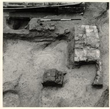 PLATE I - Detail of Forge "A" showing extent of modern disturbance around it. Note thickness of eastern (right) side which probably supported a chimney of some sort. Small hole (E. R. 1963H-10.A) drilled into the brick is visible in upper left section of the brick. Photo from South.
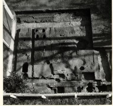 PLATE II - Overhead plan view of the entirety of Shop A-2 south of the modern garage (left) showing western wall (bottom) and Southwest corner (lower right) robbed eastern wall and Walkway B, excavated bellows holes; unexcavated Forges C and D (center and center left); excavated beam slot; and partially excavated drainage ditch to right. Note also complex of post holes outside of western wall. Photo from west.
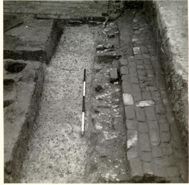 PLATE III - View of robber's trench for the Eastern wall of Shop A-2 (E.R. 1973N-10.A), with brick Walkway B to right. Note that the eastern end of "beam slot" (E.R. 1972A-10.A) cuts through the robber's trench (center). Photo from South.
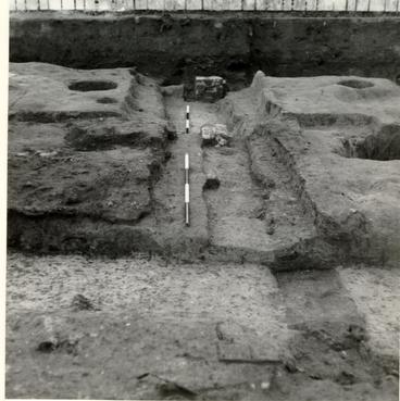 PLATE IV - Excavated robber's trench (E.R. 175B-10.A) along Shop A-2's southern end. Note several bricks left in situ, and also unexcavated drainage ditch to right of the wall line. Photo from East.
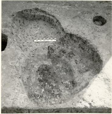 PLATE V - Detail photo of large hole between Forges D and J showing ash filled inner hole (E.R.1973T-10.A) surrounded by backfill and smaller "support" holes. Probably a barrel stand. Note later anvil support hole (E.R.1973M-10.A), upper left and portion of bellows support holes to left. Photo form North.
 PLATE VI - Northern portion of Shop A-3 showing Forge E (center) cut through by modern utility trench; Northern wall to right of forge; and western wall (also cut by utility trench) at rear. Note section of Forge A in lower left. Photo from East.
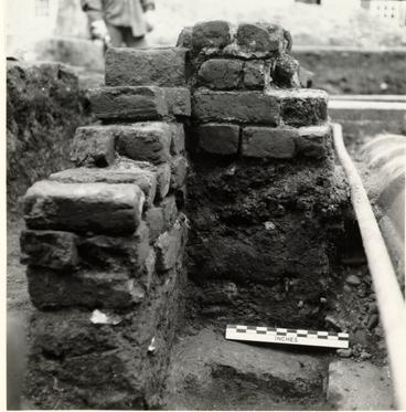 PLATE VII - Sectional view of fill beneath Forge E and its relation to the northern wall of Shop A-3. Note particularly the lense of coal clinker directly beneath the Forge brick and cut through by the Northern wall. Notice also that the Forge and Wall are not bonded together. Photo from West.
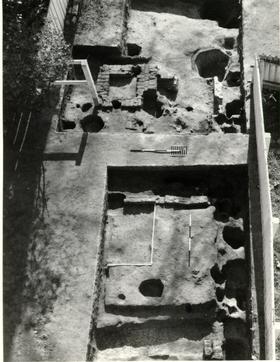 PLATE VIII - Overhead view of area of Southern shop complex showing numerous post holes along the Western property line, robbed remains of Forge F; and brick remains of Forge G. Note also E-W one course wall to South of Forge F and excavated robber's trench in lower portion of photo. Photo from northwest.
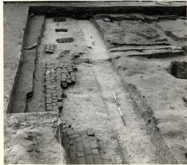 PLATE IX - Brick Walkway B and post holes along eastern side of the forge shop complex. Note ash working surface in upper right. Photo from North.
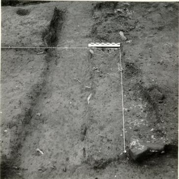 PLATE X - Detail of eastern side of robbed Forge F showing robbed remains (excavated) of the forge cutting into the robber's trench for the eastern wall of Shop B. Photo from South.
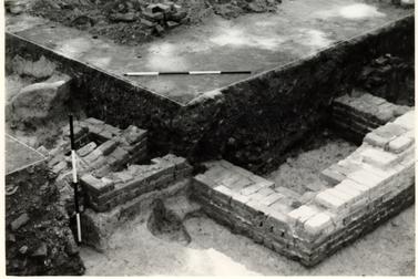 PLATE XI - West end of 1st Period Kitchen showing portion of brick chimney base and the intersection of Drain Tunnel B with the kitchen's west wall. Photo from Northwest.
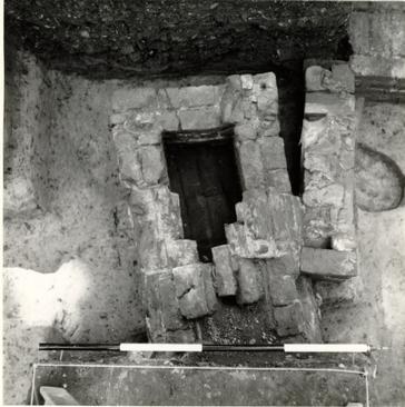 PLATE XII - Overhead plan view of entrance to Drain Tunnel B and its intersection with the northern leg of the 1st Period Kitchen's western wall, before the dismantling of the wall. Note the arch of the drain's roof which served as a portion of the building's northern wall.
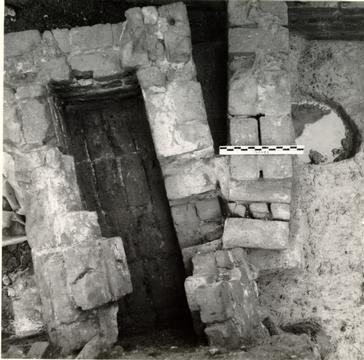 PLATE XIII - Basically the same view as Plate XII, but with the western wall partially dismantled showing how the drain was built around the bottom course of the wall and the concentration of mortar and brickbats used to fill the gap between the drain entrance and wall.
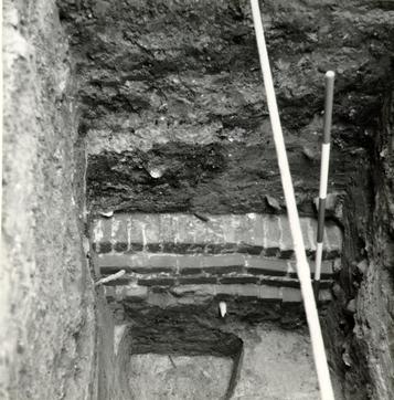 PLATE XIV - View from North of post-1770 Box Drain located West of present James Anderson Archaeological Museum with earlier (excavated) post hole (E.R.1919D-10.A) at bottom and beneath the drain.
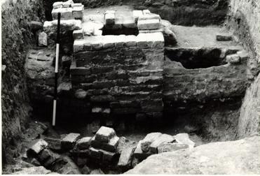 PLATE XV - View from South of Drain Tunnel A and brick box entrance to the drain. Note that brick rubble in foreground, part of the fill in Well A, underlies the drain.
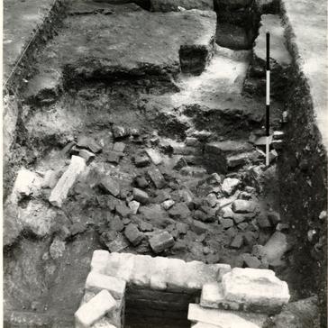 PLATE XVI - Rubble filled shaft of Well A with section of entrance to Drain Tunnel A in foreground. Note section of brick well lining, right center. Photo from North.
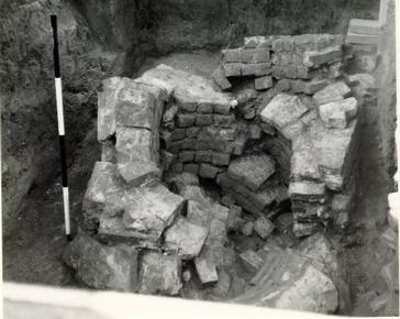 PLATE XVII - View of facing south of progress of work on Well A. Note that at this stage, three corners of the well head have been established (NE, SE, and SW). Note also dilapidated condition of the well, with large sections of the brick lining lying at all different angles. Photo from North.
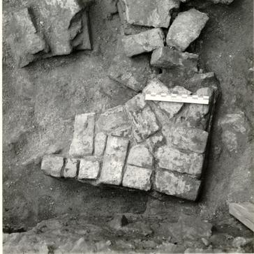 PLATE XVIII - Overhead plan view of corner of well head in Well A. Southwest corner of structure showing first period of construction.
 PLATE XIX - Well B after backfilling and partial dismantling of its southeastern side, showing excavated "builder's hole" around it. Photo from Southeast.
 PLATE XX - View from the Northwest showing detail of the remains of walkway A. Note the fill beneath the walk which lies in a shallow erosion gully dating after 1775. The Walkway served the 1st Period Kitchen which was located at the top of the photo.
 PLATE XXI - View from North showing two pairs of excavated post holes associated with Fence Lines A and B (pages 67, 68, & 69). Two vertical range poles at top of photo mark the location of two more pairs of these holes. Note also northern wall of period III shop structure and mortar adhering to the Northwest Corner.
 PLATE XXII - Northern balk of E.R.1921/27-10.A at completion. Reconstructed James Anderson House at top. Notice that the stratigraphy is generally horizontal rather than pitched as the natural ground surface is. Photo from South.