James Anderson House Archaeological Report, Block 10 Building 22 Lot 18Originally entitled: "A Preliminary Report on Archaeological Excavations at the James Anderson House"
Colonial Williamsburg Foundation Library
Research Report Series - 1226
Colonial Williamsburg Foundation
Library
Williamsburg, Virginia
1990
A PRELIMINARY REPORT ON ARCHAEOLOGICAL
EXCAVATIONS AT THE JAMES
ANDERSON HOUSE
Williamsburg
Virginia
March
1975
INTRODUCTION
Plans by Colonial Williamsburg to reconstruct the Revolutionary War blacksmith and gunsmith operations at the James Anderson House led to the necessity of making some exploratory excavations on the site. As the proposed area for reconstruction had been previously excavated in 1931, it was felt that the work would consist of merely removing fill from above those features encountered during the earlier excavations.
The excavations reported upon here were conducted in December 1974 and January 1975 by this writer under the direction of the Colonial Williamsburg Department of Archeology. Labor was provided by the CW Landscape Department.
The initial goal of the project was to re-expose the brick foundations uncovered during the 1931 excavations in order to obtain more detailed architectural information for the planned reconstruction. A secondary goal was the removal of all colonial fill which may have been left by the earlier project. The area involved was the inside of the present garage and an area, 24 by 27 feet, north of and adjacent to the garage. Later in the project it was decided to test the area south of the garage. This test comprised a 25 by 10 foot trench.
An archaeological plan from the 1931 excavations 2 was the best guide available showing what to expect. It was anticipated that we would find two rectangular brick features, possibly forges; the remains of the West and North wall of the shop; a brick chimney base; and an unidentified brick feature north of the garage. In addition, because the excavations in the 1930's were primarily brick structure oriented, much information on other non-brick features was anticipated. Extant photographs of the site during the earlier excavations showed that several areas remained virtually untouched.
The removal of the CW backfill revealed all anticipated brick features, with one exception (apparently removed by the construction of the garage), which had been left as they had been originally discovered. Also as expected, a large number of features, mainly post holes, had been previously overlooked. Among those features were three circular pits, probably associated with James Anderson's blacksmith shop, and possibly another forge.
As the work progressed, it became clear that the 1931 excavation plan did not contain sufficient information on the Revolutionary War shop for a reconstruction. The amount of unexcavated fill and un-noted features was so great that completion of the project in the short time period allotted became impossible. The existence of a coal clinker layer beneath the northern forge is the most important piece of evidence retrieved as it makes it unlikely 3 that the forge belonged to the initial period of construction (c. 1775-6). In fact, the result of the "exploratory-explanatory" excavation was only to raise new questions to be answered in expanded digging to begin in April 1975.
HISTORICAL BACKGROUND
For the purposes of this paper a full historical synopsis is not necessary.1 What is of importance is gaining an insight into James Anderson's operations, with respect to the size of his facilities and the type of work that he did.
In short, the history of the lot begins in 1723 when George Ravenscroft sold it to Cole Diggs.2 The lot changed hands several times and was the site of various shops, including a barber, milliner, and chandler through the middle of the eighteenth century. From 1760-69 Christiana Campbell kept a tavern there.3 In 1770, James Anderson, a blacksmith purchased the property.4 Anderson, who had been Public Armorer since 1767, already owned the southern portion of Lot 19. Apparently he did not immediately expand his operation to his new property. A William Drinkard maintained a tavern there from 1770-71.5 5 It is not until 1776 that documents show probable activity by Anderson on Lot 18. in 1777, a letter from Patrick Henry to Richard Henry Lee relates that Anderson had two forges, six sets of tools, eight vises, and five apprentices.6 There is no indication whether this shop was on Lot 18 or Lot 19.
There is no doubt, however, that business began to roll for Anderson during the revolution. In 1777 he had Humphrey Harwood, a brick-mason, build a forge chimney and underpin a shop.7 In November 1778 he purchased fifteen pairs of hinges for his shop;8 and in February 1779, Harwood returned to build three forge chimneys and underpin a shop.9 It is possible that, in late 1778, Anderson expanded his shop facilities by building a new structure with three forges. Further evidence that Anderson expanded his facilities is found in April 1779 when he advertised for a blacksmith and six negroes to work in his shop.10 Again in June 1779 he is advertising for blacksmiths and gun stockers.11 It appears that by 1780, when 6 Anderson went to Richmond, he had at least two shops in operation and as many as five forges.
The Frenchman's Map of 1782 probably shows Anderson's shop arrangement as it was when he left for Richmond. The map shows the main house along Duke of Gloucester Street and two long buildings along the western property line. These buildings are offset on the map which would seem a strong indication that the buildings were in fact offset. The assumption is made that these two structures were Anderson's Revolutionary War shops. (See Illustration I.)
In 1782, Anderson, having resigned as Public Armorer, returned to Williamsburg to continue his private practice as blacksmith. His account with Humphrey Harwood shows continual growth, or renovation, of his facilities. In 1786 he built two forges, in 1788 another one, and in 1789 two more.12 This yields a grand total of ten forges mentioned between 1777 and 1789. There is probably very little likelihood that Anderson had ten working forges at any given time. It is more likely that the forges simply did not have a long life and had to be rebuilt or that Anderson changed the arrangement of his shops.
Anderson died in 1798, but the property remained in his family. An 1810 insurance policy for the property makes no mention of Anderson's forge shops, so they were 7 either gone or of so little value as to make it unnecessary to insure them.13 In 1842, the house and its surrounding buildings were destroyed by fire.
It seems that for archaeological purposes the history of the site can be broken into four phases. The first would be the pre-Anderson period dating to 1770. Little is known of structures on the lot at this time though there were certainly outbuildings of some sort. The second phase is that of the Revolutionary War, or that time when Anderson was Public Armorer. For our purposes, this is the most important. Because little is known of the evolution of Anderson's use of Lot 18, this period will be said to extend from 1770 until his return from Richmond in 1782. This would then include the time wherein the Frenchman's map was drawn. The third period would extend from 1782 until Anderson's death in 1798. The final phase is that which began in 1798. This is, of course, an over simplification of a complicated site history; but, as our purposes are to differentiate Anderson's occupation from the rest, and then to distinguish his Revolutionary War operations, this should prove a useful framework to view the site. The earlier period and the later period certainly could be broken into smaller units: but, at least for now, it would serve no purpose.
8Two of Anderson's ledgers (1778-1780; 1789-1799) graphically state the extent and diversity of his operations. There is little apparent difference in the types of work Anderson did during and after the revolution, though his position as Public Armorer by necessity considerably increased his workload. His accounts make no mention of the manufacture of weapons, but often there are references to repair and cleaning of various gun parts. Without doubt, the most prevalent work undertaken by Anderson was the shoeing of horses which recurs on virtually every page of his ledger. In addition he did a considerable amount of work on chariots, chairs, and wagons of different descriptions. Most of the work was to the ironwork for the harness gear, i.e. hames, traces, tuggs, and swingletrees; but occasionally the axeltree and wheels would require attention. Because he did occasionally work with these large items, it would seem possible that his shops, or at least one of his shops, would have been open on one or more sides in order to allow working on them right at the forge.
Second only to the shoeing of horses, Anderson's business dwelt upon the repair of tools. He made and repaired hoes, rakes, mattocks, ploughs, chisels, hatchets, axes, spades, and many other commonly used tools. One of the most common processes that occurs over and over in the ledger is called "laying", in which the blacksmith would 9 replace the steel cutting edge on various implements such as axes, hoes, ploughs, and chisels. This was done because the steel held a sharp edge longer than iron and could be easily replaced. Anderson's Ledger C (1789-1799) shows that not all of his business after the war was for individuals. In fact, one of the largest accounts was with the "Stage". Although little is presently known of the stage, Anderson did work for them on a continuing basis for almost two years (1789-1791). The work consisted of shoeing horses, repairing harness gear, and repairing various parts of the coaches. It seems that it was a rather sizable task for Anderson as the entries occur almost every other day for the entire two year period. Another important account was with the public jail. Most of this work consisted of repairing locks and keys and the making and putting on of leg irons. Other public work was done by Anderson at the Capitol and at the Public Hospital.
The more interesting parts of the ledgers deal not with those common jobs, but rather with the one-of-a-kind jobs that tell us much about the flexibility and competence of the eighteenth century blacksmith, e.g. making a clapper for a bell, mending a tea "kittle", and making a pegging awl for a shoemaker. Although such items are by far in the minority, their constant recurrence show that the citizens knew where to go to get things--just about any things--fixed or made.
METHOD OF EXCAVATION
Due to the fact that the entire site had been previously excavated, and because almost half of the anticipated area of excavation was within the garage, one major deviation was made from standard archaeological method. That was that the entire area was laid off within the confines of the master grid and then excavated to the undisturbed layers without regard for ten foot squares or balks. This meant that the CW backfill inside the garage was removed with one ER number (ER 1907) and outside of the garage with another (ER 1908). Upon removal of all of the backfill, the grid was re-imposed on the site for more accurate horizontal control. The main reason for this approach was the instability of the loosely packed backfill which certainly would have led to collapsing balks. Also, any artifacts in the backfill were already removed from their original position so control of their location was not considered critical.
In the trench to the south of the garage, this basic plan was not adhered to as the trench was begun as two separate ten foot squares then expanded. Each square was allowed its own ER number (ER 1917 and ER 1918).
ARCHAEOLOGICAL EVIDENCE
The 1931 excavations of the forge area of the James Anderson House provides a limited amount of information concerning the features encountered. A horizontal plan of the excavation and a few photographs gave some idea of what to expect. The plan shows a variety of brick features and, through elevations, gives some indications to their vertical association. The photographs were useful in determining the extent of the previous excavations and in giving the first clue that much undisturbed till was left.
NORTH OF THE GARAGE
In the 24 by 27 foot area to the north of the garage, the removal of the CW backfill uncovered a variety of features. All of the brick features shown on the 1931 plan were re-exposed; and, in addition, several post holes were revealed. A great deal of unexcavated fill remained, particularly to the north where a series of four test trenches cut through the otherwise undisturbed fill. Artifacts recovered from the backfill ranged widely in date from the eighteenth century to the 1930's, among them fragments from a molded white saltglaze bowl hitherto without parallel in the Williamsburg archaeological collections.
BRICK FORGE A
Approximately in the center of the excavated area were uncovered the remains of a rectangular brick box, 12 probably a forge. A modern utility line, laid sometime after 1931, cuts through the center of the forge. The structure measures 6 by 4 feet and is constructed in English bond with oyster shell mortar. The east and south sides of the box are 1½ courses wide, while the west side is 2 courses and the north side only 1 course wide. The previous excavations had removed all of the fill around the forge, thus destroying any direct dating evidence. It was constructed, however, upon 2½ feet of fill. A sherd of creamware, seen in the section beneath the forge, gives a terminus post quem of c. 1770. Further excavation of the levels beneath the structure may push the date later. (See Illustration III.)
The forge is also constructed on top of a layer of clinker and ash. As this deposit is probably waste from an earlier forge, there is a strong possibility that the structure was not one of Anderson's Revolutionary War forges. The fact that the ash is so concentrated does, in any case, indicate that another earlier forge would have been located nearby.
NORTH AND WEST WALLS
Running north of the brick forge, a section of wall was found. The base of the wall is ten inches below that of the fire box and is not bonded to it. The one course wide, oyster shell mortared wall follows no standard bond, most of the bricks being laid as headers. The top 13 remaining course is laid in rowlock and may have been the top course on which the wooden sill for the structure would have been seated.
A foot and a half west of the forge, the wall has been cut through by an unknown disturbance. The wall picks up again after a foot and a half gap and continues for eight inches where it becomes 1½ courses wide and returns to the south along the western edge of the excavated area.
The western wall is more uniform than that at the northern, being constructed in English bond with oyster shell mortar. It extends from the northwest corner to the present garage. A bottle base dating from c. 1710 can be seen in the fill beneath the wall.
BRICK CHIMNEY BASE
Along the east side of the excavation a large bracket-shaped chimney base was found. Constructed of very hard fired brick laid in English bond with oyster shell mortar, the two course wide structure measures 8 feet 11 inches across the back and has 5 foot legs. Any evidence of a builder's trench had been removed during the previous excavations.
To the south of this chimney base, a section of an underpin projects from the edge of the excavation. The chimney base and underpin are probably from the same structure (most likely a kitchen judging from the size of the chimney) which shows on the 1782 Frenchman's Map.
14(See Illustration I) The building extended eastward from the excavated area.
UNIDENTIFIED BRICK STRUCTURE
Located between the chimney base and the forge was unearthed a brick structure of undetermined function. Constructed of soft, deep red brick, the 2½ course wide structure measures six feet long. To the north, a closer is evident in the brickwork indicating that the surviving wall's end was the original corner. The southern end of the feature has been cut through by an unidentified disturbance. The brickwork turned at this point, as another, apparently related, piece of brickwork is found southwest of the larger area. These two sections of brick, when seen together, give the impression of being a chimney base or possibly part of another, earlier forge.
A soil stain extends northward from the feature, and three and a half feet from the end of it are four brick bats which appear to be laid. Further excavation of this area is necessary for proper interpretation.
POST HOLES
Eight post holes were located in the area north of the garage. Of these, only one was excavated (ER 1910 A). It was located near the northeast corner of the excavated area and measured 1 by 2 feet and 2 feet deep. It contained a six inch square post mold. No artifacts were recovered 15 from the mold, but fragments of white saltglaze stoneware in the hole fill indicate a colonial date.
A series of three holes was located along the garage wall. One of the three posts had apparently been repaired and was represented by two intersecting holes. The holes are on eight foot centers and may be the remains of an east-west fence line.
FILL AND STRATIGRAPHY
Colonial fill left undisturbed by the CW excavations in 1931 is most prevalent to the north end of the excavated area. Along the north face of the garage some fill has been left, sloping gradually into the ravine to the west. In the immediate vicinity of forge A, all stratigraphic layers have been removed, save for those beneath it. At this stage of the excavations, however, none of these undisturbed layers has been removed.
GARAGE
The present garage is a 1940 reconstruction based partially upon the west and south walls found during 1931 archaeological investigation. Regrettably, the construction of the garage, with its five foot deep brick footings, completely obliterated any evidence of those walls.
The removal of the CW backfill inside the garage again revealed several important features. Apparently some of the brickwork shown on the earlier excavation plan was 16 removed before the construction of the modern building and certain areas of the brick, towards the north end of it, no longer exist.
BRICK FORGE B
Another rectangular brick box, similar to the one north of the garage, was found slightly south of the center of the building; and it, too, measured 6 by 4 feet. The west side of the box was 2 courses while the remaining three sides were only 1½ courses wide. The interior faces of the brick work show no evidence of burning, although none would be expected as the fire would have been built on a grate at a higher level. Again, any direct dating evidence for this feature was removed by the earlier excavations. There is, however, a scatter of brick chips and mortar around the west end of the forge which may conceivably be construction debris. This level was not excavated.
ROUND PITS
Two feet northeast of the forge a circular soil stain was found which proved to be a pit 3½ feet in diameter and nine inches deep (ER 1916 A). The fill in the pit was a mixture of sand and mottled yellow clay mixed with large quantities of coal ash and is probably associated with Anderson's blacksmithing operation. The fill contained numerous fragments of badly corroded iron. Although 17 at this stage of the artifact analysis only a few of the pieces have been identified, they include fragments of hinges, equestrian gear, a pintle, and many nails.
To the south of the forge another pit was located with similar fill (ER 1916 B). The pit had been bisected by the builder's trench dug for the garage. If the existing arc were extrapolated, this pit would also measure 3½ feet in diameter and have a depth of nine inches. The fill in this pit represented two separate deposits. The upper layer (ER 1916 B) contained quantities of rusted iron and coal: while the lower layer (ER 1916 C) had less coal and ash but retained quantities of the rusted iron. The lower layer also contained a child's brass thimble.
It is possible that these pits served an integral function in the blacksmith operation. Because of their uniform roundness (which is difficult to achieve with a square bladed eighteenth century shovel) it may be speculated that these pits were used to seat barrels of water used in the tempering of the iron. Their presence on two sides of the forge indicates that the fire may have been used by two smiths at the same time, one working on each side.
POST HOLES WITHIN THE MODERN GARAGE
A series of six holes was found north of the forge foundation. They apparently represented two periods, as several of the holes intersect each other. Both periods 18 of holes contained fragments of pearlware dating them after 1785, thus apparently post-dating the destruction of the forge shop. This was determined by placing them on the 1931 plan where they are seen to neatly match up with the gaps in the now missing brickwork (see Illustration II). These holes probably represent an east-west fence line.
COLONIAL FILL WITHIN THE GARAGE
Not as much fill was left undisturbed inside of the garage as outside. There appear to be four basic layers again sloping to the west. As yet, none of these layers has been removed.
SOUTH OF THE GARAGE
In the 25 by 10 foot test trench opened south of the garage, several important features were encountered. The 1931 excavations had unearthed only a three foot section of the west wall and a section of a colonial brick walkway.
WEST WALL
At the west end of the excavated area the bottom two courses of the western wall were found. Again, laid in English bond with oyster shell mortar. The wall appears to be an extension of the wall found to the north of the garage and upon which the garage is constructed. It spans the entire ten foot width of the trench and continues to the south.
FORGE C
An area of black coal clinker and ash, measuring 6½ by 4½ feet was located along the north edge of the trench. Previously unnoticed, it is possible that this feature represents the remains of a forge robbed of virtually all its brick. This is likely because the feature is in perfect alignment with the other two forges. (See Illustration II.) A brick rubble layer overlies a portion of the feature and may be debris left behind when the brick was removed. Two feet east of the southwest corner of the feature, three brick bats were found in such a position as to make it impossible for them to have been moved from their original location. The oyster shell mortar on top of the three bricks is intact. This feature was not excavated.
CIRCULAR PIT
One foot south or the forge, an irregular shaped feature, 3½ by 4½ feet, was found. It contained mixed ashy fill similar to that found in the two pits inside the garage (ER 1918 C). This fill contained pearlware, dating it post 1785, and fragments of rusted iron. Beneath this irregular feature, the pit rounded out and had a mottled clay fill (ER 1918 G). The pit was three feet in diameter and two feet deep. Creamware in this lower level dates its backfilling to after 1770. Rusted iron was also found in the layer.
20It is believed that this pit served the same function as the other two; that is, it was used to seat a barrel of water. The reason for the difference in depth, however, is not readily apparent. Further excavation, particularly directly north of the forge, should help in answering this question.
BRICK WALKWAY
Along the eastern end of the trench a section of a brick paved walkway was found. This walk is shown on the 1931 drawing and extends along the eastern side of the garage. It is constructed of randomly laid brick and brick bats.
POST HOLES AND OTHER FEATURES
Three post holes were found along the west side of the brick wall. One cuts into the wall, thus post-dating its destruction. Another post hole was located along the southern edge of the forge. None of these holes were excavated.
Between forge C and pit was found a scatter of brick rubble. It had been cut through by the pit and one of the post holes. This feature was not excavated.
PRELIMINARY CONCLUSIONS
It was believed at the outset of the project that the removal of the CW backfill would reveal the architectural information necessary to complete reconstruction plans for James Anderson's Revolutionary War blacksmith shop. With the limited amount of archaeological information gathered, however, it became obvious that such was not the case. Instead of confirming information, the excavations have raised many new questions.
The existence of the ash and coal layer beneath the forge A is the strongest information to date that the fire box was not one of Anderson's original forges, but was rather associated with some of his post-war improvements. The fill beneath this forge will be invaluable in helping to date its construction. This is important because the archaeological evidence available does not mesh with the structures shown on the Frenchman's map of 1782, which probably represents those shops Anderson had built during the revolution. This map shows the two shop buildings offset a considerable distance; whereas, the archaeological data indicates a single long structure. Further, the map places the shops closer to the main house than is apparent from the presently available archaeological information. There may be some danger in relying too heavily upon the details of a map drawn at such a small scale; however, it has proven to be invaluable in locating structures in 22 Williamsburg. The fact that the mapper took pains to show the structures offset and close to the house would seem strong evidence that they were, in fact, offset and close to the house. If that is the case, there maybe no recognizable evidence of the earlier structure yet excavated.
It is conceivable that the shop structures in question were not brick but were constructed on wooden piers. They may, in fact, have been more on the order of sheds with open sides to allow work on wagons and carts, which could be brought right to the forge. Also, of the ten forges mentioned in Humphrey Harwood's ledger, only three mention forge chimneys. The forges themselves then may not have had chimneys but, instead, merely a hole in the roof to allow the smoke to escape. This would allow all four sides of the forge to be used at once. It would also mean the existence of massive chimney bases would be unlikely.
Most important is the need to expand the scope of the excavation northwards toward the house in order to find evidence of the structure on the Frenchman's map. The entire length or Lot 18, from the present reconstructed house to Francis Street, should also be examined. With an operation as large as Anderson's, it would be expected to extend throughout the entire lot. The location and excavation of trashpits and wells filled during the Revolutionary War period will be of great importance in gathering information about that period of the site's 23 history.
The existence of a good deal of undisturbed fill and the location of another forge, not noted in the earlier excavation, makes it obvious that to leave the archaeological end of the project at this point would be a mistake. It will only be through the most careful techniques that the missing information can be pieced together.
Footnotes
Illustration I
 Detail
from Frenchman's Map (1782)
Detail
from Frenchman's Map (1782)
Note: Hatched structures are probably Anderson's Revolutionary War shops. Note the offset and proximity to the main house.
Illustration II
Overall Plan of the Excavation thus far [Digital version unavailable ]
Illustration III
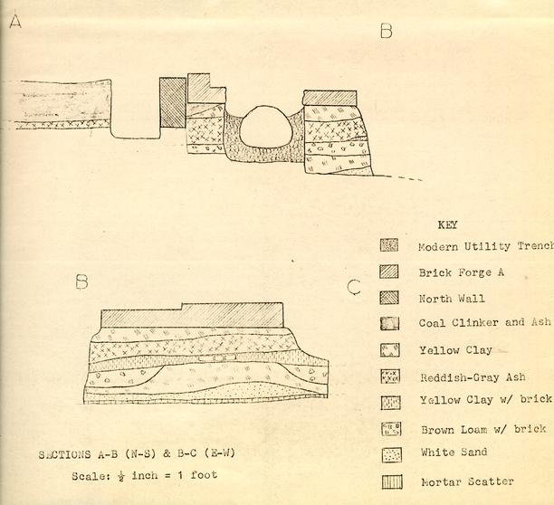 SECTIONS A-B (N-S) & B-C (E-W)