Barraud (Dr.) House Archaeological Report, Block 10 Building 1Originally entitled: "Archaeological Report Block 10, Area F (Ryland Lot)"
Colonial Williamsburg Foundation Library Research Report Series — 1194
Colonial Williamsburg Foundation Library
Williamsburg, Virginia
1990
ARCHAEOLOGICAL REPORT
BLOCK 10, AREA F
(Ryland Lot)
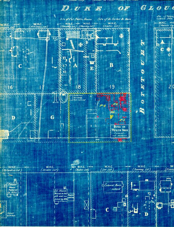
The area known as the Ryland lot is located in the southeast portion of Block 10 and was formerly part of Colonial Lot 19. It is bounded on the east by Botetourt Street and on the south by Francis Street.
Archaeological investigations of this lot were executed during the summer and early fall of 1941. The remains of several early outbuilding foundations, including two wells, brick drains and walks, were uncovered.
A — Dwelling
(F-1 on Archaeological Key Map)
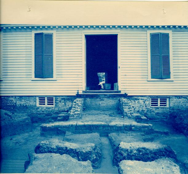
This building still existed on most of its original foundation, although the west foundation wall appeared to be of a later period than the central and eastern foundation walls. Fragmentary remains of a 9" wall (a-l) were found in the basement. It was parallel to and approximately 9' east of the present west wall of the building. This is probably the original west end before the addition was added.
On the south side or front of the building was the foundation of a 13' x 0" x 7' - 6' stoop or small porch (a-2). This centered on the building and appeared to have the same period of brickwork as the west addition. On each side of the stoop were the remains of a brick drip or gutter to catch the water from the southern slope of the roof. No evidence of a brick drip was found in the rear of this building.
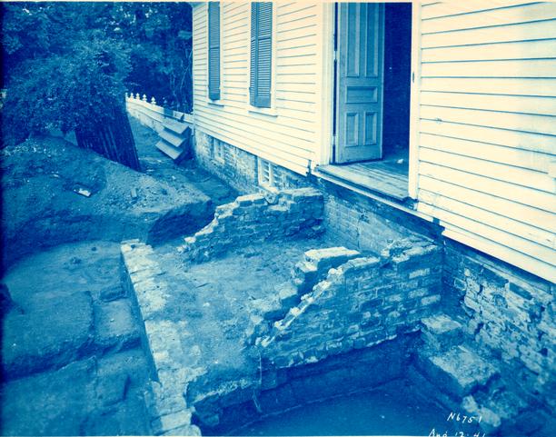
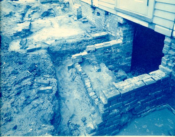
On the north side or rear of the building was the foundation of a 19' — 3" x 8' — 3" porch (a-3) which contained several periods of brickwork, on account of repairs or underpinning at various times.
2Just west of the rear porch are the basement steps (a-4) which were in a very dilapidated condition and showed evidence of having been repaired many times. These steps were probably constructed at the time the west addition was added. The original ones probably entered from the west but all traces of such were destroyed when the basement was lengthened. (See Architectural Report).
See photographs N-6750, N6751, N6754, and N6755.
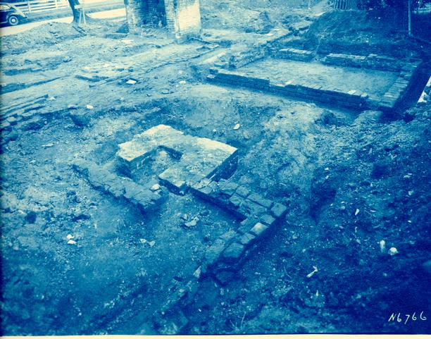
B — Kitchen
(F-2 on Archaeological Key Map)
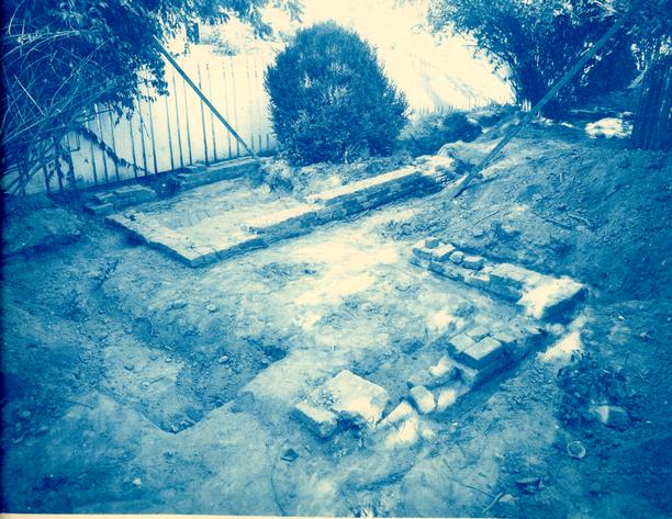
Ten feet north of the dwelling (A) was an existing outbuilding known as the kitchen, recently used as a garage and servants quarters. This building was 30' x 18' and of modern construction although some parts of it rested on much earlier brickwork. There was a chimney (b-1) in the center of the building which showed evidence of originally having been an outside chimney on the south end of an earlier structure.
After the modern building, including its foundation, was demolished, archaeological investigation of the area was undertaken which brought to light the remains of several periods of brickwork. The existing chimney had been built on a slightly earlier chimney foundation. This earlier foundation consisted of ten or twelve courses of brick — well constructed.
Three periods of underfire paving were found in the fireplace. The top and bottom were of brick while that in the middle was of stone. Between each layer of paving was a layer of sand which acted as a cushion. The two bottom layers of underfire paving appeared to be the same period as the early or lower portion of the chimney while the top layer was of the same period as the top or late portion.
3On the north side of the chimney (b-1) were the fragmentary remains of a 37' —9¼" x 19' — 5½" building foundation which appeared to be the same period as the base or original brickwork of the chimney. Its wall thickness was 9" with the south end being connected to each side of the chimney. This appears to be the original kitchen foundation which was built on the site of an earlier structure. Parts of the first or earliest building on this site may have been incorporated into the second building since this is much longer than most early kitchens found in Williamsburg by Colonial Williamsburg. There were two cross walls (b-2), one almost in the center of the building while the other was eleven feet from the chimney. These probably supported partitions which divided the building into two rooms with a hallway between. Considerable floor paving was found in the northern section of the building. It probably covered the floor of that room completely at one time and overlapped part of an early forge or chimney foundation.
Just outside of the west wall and also north of the chimney were the remains of a brick drip or gutter drain — used to carry water away from the building.
Fragmentary remains of a brick walk extending from the kitchen to the dwelling were uncovered — also a small portion of brick walk which ran east from the garden to Botetourt Street.
| Brick sizes - | 8-¾" x 4½ x 3" |
| 8-5/8" x 4¼ x 2½" | |
| Color - | Red and buff |
| Bond - | English |
| Mortar - | Shell |
| Condition - | Poor |
See photographs N-6766 and N-6767.
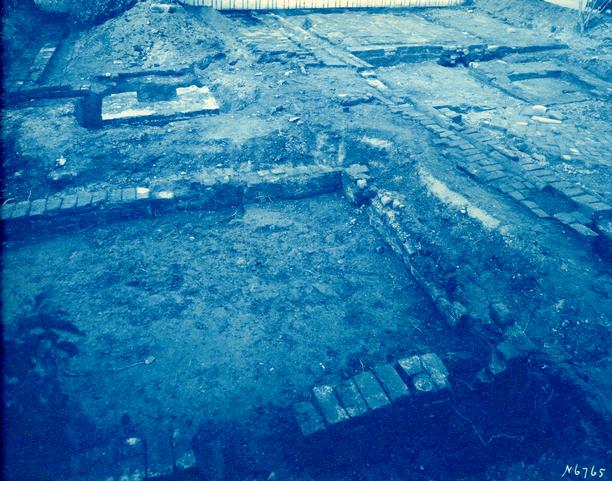
C — Forge or Blacksmith Shop
(F-2 on Archaeological Key Map)
Near the center and also at the north end of the kitchen foundation were the remains of two earlier chimneys or forge foundations (c-1) (c-2). Many fragments of rusty and burnt pieces of iron were found in this immediate vicinity, including several layers of cinders and ashes. This is very typical of what has usually been found on sites of colonial blacksmith shops by Colonial Williamsburg.
Foundation walls of the shop were not found although just to the west were the remains of a small chimney (c-3) and west wall (c-4) of what appears to have been a leanto on the west side of the shop or earliest building.
| Brick size - | 8" x 4" x 2½" |
| 8½" x 4¼" x 2¾" | |
| Color - | Red |
| Bond - | English |
| Mortar - | Shell |
| Condition - | Poor |
See photographs N-6765, N-6766 and N6767.
D — Privy
Five feet west of the southwest corner of the kitchen foundation (B) the foundation walls of an 12' - 1¾" x 8' - 1¼" outbuilding were uncovered. This showed evidence of being the remains of an early privy which appeared to be the same period as the forge or blacksmith's shop. It may be noted that part of the brick walk, from the kitchen to the dwelling, overlapped the east wall of this foundation. (See Archaeological Drawing.)
| Brick sizes - | 8" x 4" x 2½" |
| 8½" x 4¼" x 2¾" | |
| Color - | Red |
| Bond - | English |
| Mortar - | Shell |
| Condition - | Poor |
See photographs N-6765 and N-6766.
E — Wells and Brick Drain
Several feet west of the privy foundation D were two wells. The one to the north (e-1) was modern, and probably dug sometime during the late nineteenth century. It had been backfilled with brick bats and rubbish of a very late period — then covered with a well house of modern construction.
Six feet south of the modern well were the remains of an early well (e-2). Its diameter was approximately 4' — 0" with the top of the brickwork being 2' — 6" below the present grade. The brick lining extended to a depth of only six feet. Below this point it had caved in leaving the existing well lining supported only by the surrounding earth which adhered to it. The fill was excavated to a depth of only ten feet because of the danger involved in digging more deeply. The debris from this well hole was composed mostly of bricks, shell mortar and black earth mixed with a few fragments of eighteenth-century china, broken ale bottles and scrap iron.
The well lining was constructed of radial brick whose dimensions are as follows:
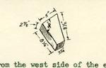
Running north from the west side of the early well were the fragmentary remains of a small brick box drain (e-3). It was approximately 1' — 9" below the present grade and evidence showed that it originally ran onto the lot to the north and probably emptied into the large tunnel drain located just south of Dr. Carter's Brick House. The bottom of this drain was of 7½" x 7½" paving tile while the top and sides were of 8¼" x 4" x 2½" brick.
6After the box drain was done away with, a brick gutter drain (c-4) was built in its place, but at a higher level. This second drain did not extend to the present Carter lot but turned and ran west approximately five feet from the property line. It may be that sometime between the construction of the two drains, Colonial Lot 19 was divided into two portions.
F — Garden Wall
Along the dividing line between the north and south portions of Colonial Lot 19 was the foundation of an 8¾" garden wall 56 feet in length. The exact period of construction was not determined, although it proved to be built later than the kitchen and probably earlier than the second drain. On the south side of the wall were several buttresses spaced from 11 to 15 feet apart.
| Brick size - | 8½" x 8¾" x 4" x 2½" |
| Color - | Red and buff |
| Bond - | English |
| Mortar - | Shell |
| Condition - | Fair |
See photographs N-6776A and N-6776B.
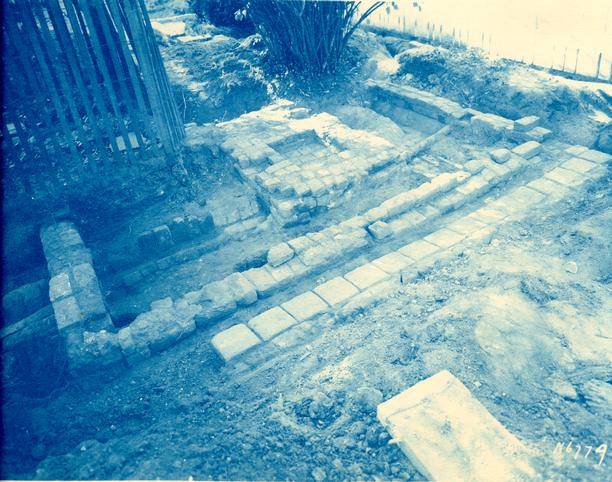
G — Smokehouse
(F-4 on Archaeological Key Map)
Eleven feet northwest of the modern well (e-1) was the foundation of a 12' x ½" x 8' -½" smokehouse. This foundation was constructed, both drains had been discontinued and the area backfilled. In the center were the remains of a 3' x 8½" x 3' x 7½" square fire pot which appeared to have been used considerably at one time.
On the east side was a brick drip built of brick and paving tile, probably salvaged from the early drain.
7| Brick size - | 8¾" x 4" x 2½" and bats |
| Color - | Red |
| Bond - | English |
| Mortar - | Shell |
| Condition - | Fair |
See photograph N-6779.
H — Privy
Only a small portion of the south and east wall, including the southeast corner of this foundation were found some 17' — 6" west of the smokehouse. According to slight evidence of fill, etc., it appeared to have supported originally a 12' — 0" x 8' — 0" building — of the same period as the smokehouse.
| Brick size - | 8½" to 8¾" x 4" x 2¾" and bats |
| Color - | Red |
| Bond - | English |
| Mortar - | Shell |
| Condition - | Poor |
See photograph N-6780.
I — Modern Outbuilding Foundation
Overlapping the remains of foundation H was a modern foundation whose dimensions were 12' — 0" x 8' — 3". It was built against the garden wall and it may be safe to say that the outbuilding which once existed on this foundation was moved from foundation H since the dimensions appear to be practically the same.
Sixty feet west of this foundation is an early privy which had been moved to this location and placed upon a modern foundation. According to the size and age of this outbuilding, it is possible that at one time it rested on foundation H — later moved to foundation I and finally moved to its present site.
See photograph N-6780.
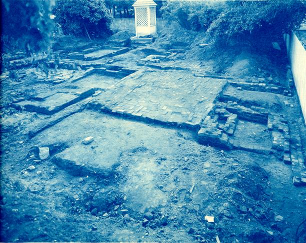
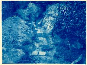
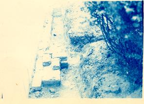
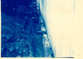
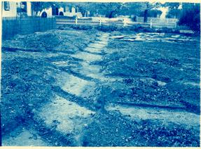
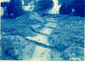
J — Marl Walks
In the center portion of the Ryland lot was found evidence of several marl walks. These walks appeared to be the remains of a formal garden — originally laid out in the shape of several rectangles. See archaeological drawing of this area which shows length, width, grades, etc. of these walks.
It may be noted that most of these walks are located on Colonial Williamsburg Foundation Lot 18. There is a terrace just west of the above mentioned walks which had a 3' — 0" drop to a level area which may once have been a sunken garden. This area was carefully excavated but nothing was found to determine its original purpose.
See photographs N6809C and N6809D.
EK — Early Outbuilding Foundation
Near the northwest corner of the existing Ryland house were found the fragmentary remains of an early outbuilding. One dimension of this building was 14' — 2" while the other could not be determined. This foundation was much earlier than the marl walk or the Ryland House and appears to be about the same period of construction as foundations C and D.
James M. Knight
Colonial Williamsburg
Architectural Department
December 28, 1942