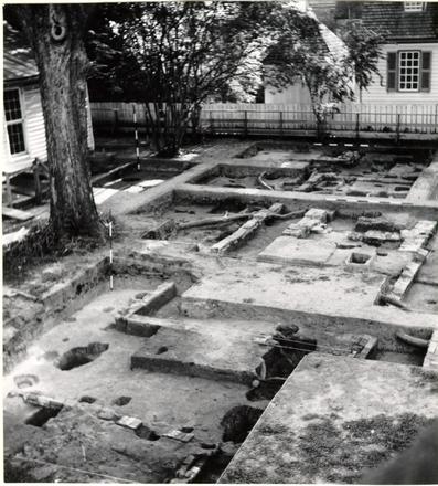
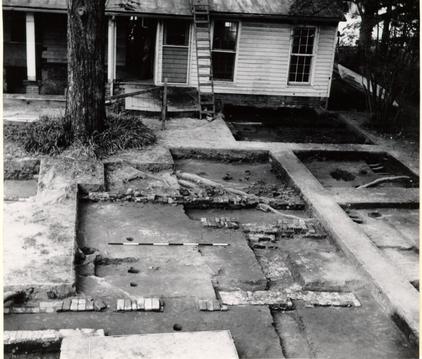
Wetherburn's Tavern Archaeological Report, Block 9 Building 31 Lot 20 & 21Originally entitled: "Wetherburn Site - Report on the Archaeological Excavations of 1965-1966 Volume I Part 2 Excavation Photographs"
Colonial Williamsburg Foundation Library Research Report Series - 1184
Colonial Williamsburg Foundation Library
Williamsburg, Virginia
1990
THE WETHERBURN TAVERN SITE
Block 9, Areas N & C
Colonial Lots 20 & 21REPORT ON ARCHAEOLOGICAL EXCAVATIONS OF 1965-1966
THE EXCAVATION PHOTOGRAPHS
The volume of illustrations was prepared by Mr. Glen Kirk to accompany a text that was not completed before he left Colonial Williamsburg. An interim report on the archaeology of Wetherburn's Tavern was subsequently written (April, 1968) and Mr. Kirk's volume is now issued as an addition to it. The captions have been edited and introductory map drawn by Mrs. Paulette Hancock has been added, otherwise the volume remains more or less as Mr. Kirk intended it.
INH
November, 1968
CONTENTS
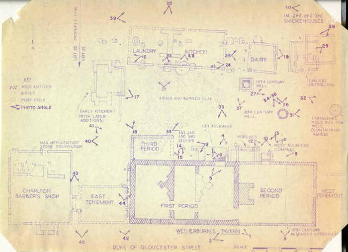
| Figure 1. Northwest corner of tavern's first period north wall. |
| 2. The tavern's west addition builders' trench at north junction with first period building. |
| 3. Underpinning beneath the "Great Room." |
| 4. Sealed west bulkhead entrance in the tavern's south wall. |
| 5. West bulkhead entrance into the tavern's first period basement. |
| 6. Recent coal cellar cutting through colonial porch foundations, with sealed bulkhead entrance to the first period tavern. |
| 7. Southeast corner of coal cellar. |
| 8. South porch area associated with the tavern's first period structure. |
| 9. South porch foundations against the south wall of the tavern's west addition. |
| 10. Sealed bulkhead entrance through the south wall of the tavern's west addition. |
| 11. East wall of second bulkhead showing nosing hole. |
| 12. West wall of second bulkhead with remains of steps and nosing holes. |
| 13. First period bulkhead following removal of second, with line of steps cut in clay and east wall. Foreground left shows half west wall bonding with addition foundation. |
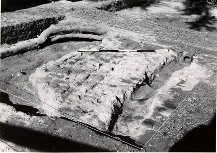
| 14. Stratigraphic section beneath the tavern's southeast shed addition. |
| 15. Stratigraphic passing beneath south foundation of the tavern's southeast addition. |
| 16. First period chimney for southeast outbuilding with northeast corner of kitchen in foreground. |
| 17. Detail of northwest corner of first period southeast outbuilding with foundation of north addition passing over first period wall. |
| 18. First and second period southeast outbuilding. |
| 19. Foundation of the kitchen after excavation. |
| 20. The kitchen chimney. |
| 21. Kitchen chimney with north foundation in foreground. |
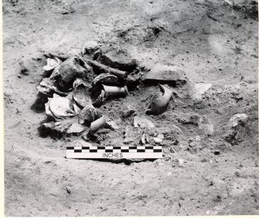
| 22. Two wide-necked bottles in situ under north kitchen wall. |
| 23. Group of four English and one French wine bottles in pit below north kitchen wall. |
| 24. A group of ten wine bottles inside north-west corner of kitchen. |
| 25. Wine bottle groups east of dairy foundation. |
| 26. Southwest outbuilding complex. |
| 27. Northeast corner of third period smokehouse with range pole to left of corner standing in builders' trench. |
| 28. Builders' trench west of third period smokehouse foundation. |
| 29. First period southwest outbuilding foundation and parts of subsequent structures. |
| 30. Trash pit south of smokehouse area. |
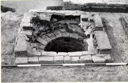
| 31. Nineteenth-century paving over first eighteenth-century well. |
| 32. The first, never-completed, well with trash debris in situ. |
| 33. The second well at an early stage of excavation. |
| 34. The second well in course of excavation. |
| 35. The second well with steel conduit inserted. |
| 36. The second well following completion, with water rising in shaft. Timbers in water had provided footing for excavator working at bottom. |
| 37. Head foundation for extant nineteenth-century well. |
| 38. Nineteenth-century pavement south of tavern and northeast of extant wall. |
| 39. Trash pit southeast of kitchen. |
| 40. Eighteenth-century walk at southeast corner of southeast addition to first period tavern. |
| 41. Eighteenth-century walk south of southeast addition to first period tavern. |
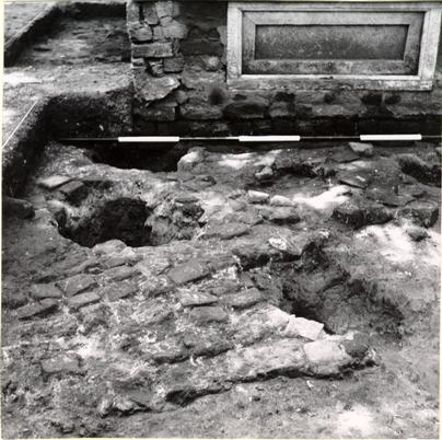
| 42. The east tenement's west foundation piers. |
| 43. East tenement chimney southeast corner with foundation wall of Charlton Shop in right foreground. |
| 44. South addition to east tenement. |
| 45. Spread of "English" brick beneath east tenement. |
| 46. Architectural fragments. |
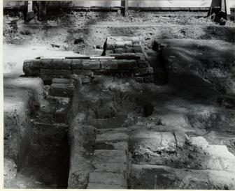
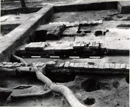
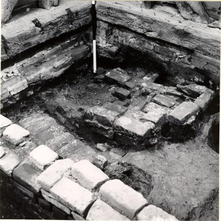
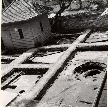
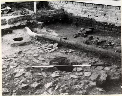
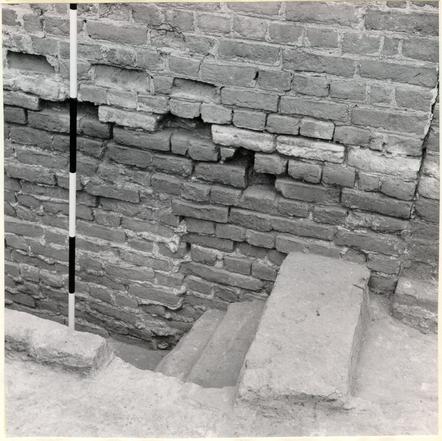 Figure 1. Northwest corner of the tavern's first period north wall showing unexplained underpinning at left. Photo from northwest. 68-DB-2953
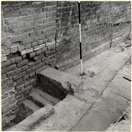 Figure 2. The tavern's west addition builders' trench at north junction with first period structure. Ranging pole marks width of trench. Photo from northeast. 68-DB-2979
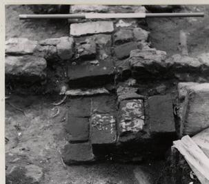
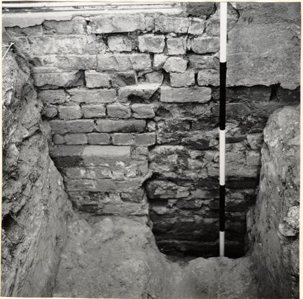 Figure 3. Underpinning (at right) beneath the "Great Room," inserted when the basement was enlarged in the nineteenth century. 68-DB-2954
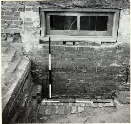 Figure 4. Sealed bulkhead entrance in the tavern's south wall. (First Period) Horizontal ranging pole across remaining step. Photo from south. 68-DB-2955
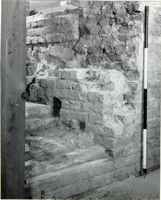 Figure 5. West bulkhead entrance into the tavern's first period basement showing nosing holes and original south wall brickwork cut through by opening. Photo from northeast. 68-DB-5956
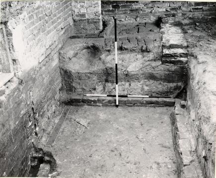 Figure 6. Recent coal cellar cutting through colonial porch foundations, with sealed bulkhead entrance to the first period tavern to left. Stratigraphy in section shows secondary builders' trench on left. Photo from west. 68-DB-2957
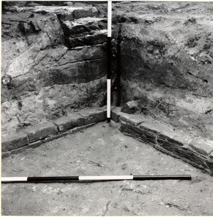 Figure 7. Southeast corner of coal cellar. Remains of wooden timbering abutting footing at right with remains of corner timber standing behind vertical ranging pole. Photo from northwest. 68-DB-2958
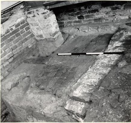 Figure 8. South porch area associated with the tavern's first period structure. Third period porch foundation to the right cut through by the coal cellar in left foreground. Second period porch foundation (overlying first period foundation) to left of modern pier. Photo from southwest. 68-DB-2959
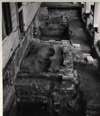 Figure 9. South porch foundations against the south wall of the tavern's west addition, with bulkheads in foreground and coal cellar in background. Nineteenth-century steps are visible to right of porch, and corner pier of nineteenth-century porch beyond step area. Photo from west. 68-DB-2960
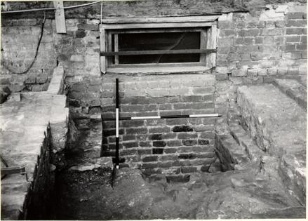 Figure 10. Sealed bulkhead entrance through the south wall of the tavern's west addition immediately west of porch area and beneath the "Great Room." Sooted bricks used in closing wall. Photo from south. 68-DB-2961
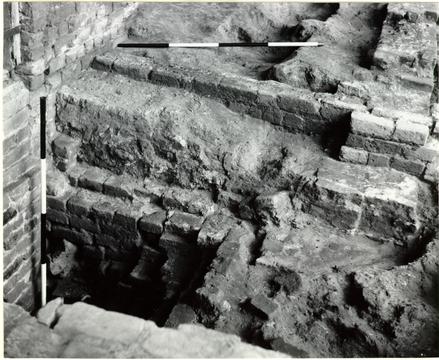 Figure 11. East wall of second bulkhead (as Fig. 10) showing nosing hole. The third period porch foundation (c. 1790) is seen above it, which the second period porch foundation projects beneath at right, and is cut through by the construction of the first bulkhead. Photo from southwest. 68-DB-2962
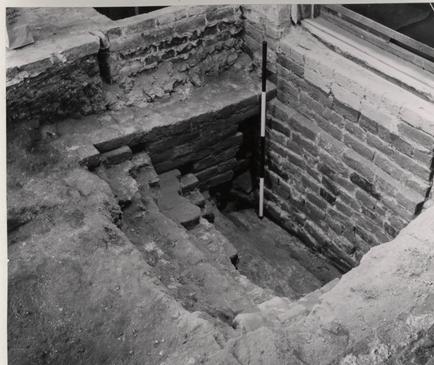 Figure 12. West wall of second bulkhead with remains of steps and nosing holes. (see Fig. 10) Photo from southeast. 68-INH-2849
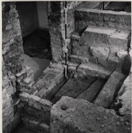 Figure 13. First period bulkhead following removal of second, with line of steps cut in clay and east wall. Foreground left shows half west wall bonding with addition foundation. Photo from southwest. 68-INH-2848
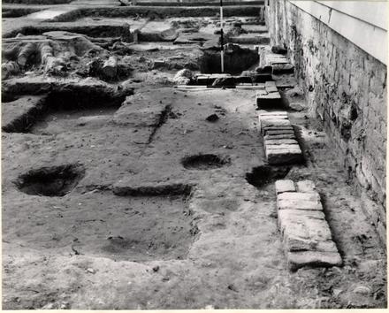
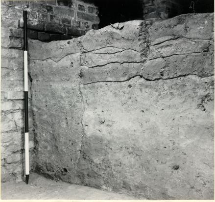 Figure 14. Stratigraphic section beneath the tavern's southeast shed addition showing secondary(?) builders' trench abutting the first period house foundation. Photo from southwest. 68-DB-2963
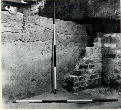 Stratigraphy passing beneath south foundation of the tavern's southeast addition; remains of modern retaining wall in right foreground. Photo from northwest. 68-DB-2964
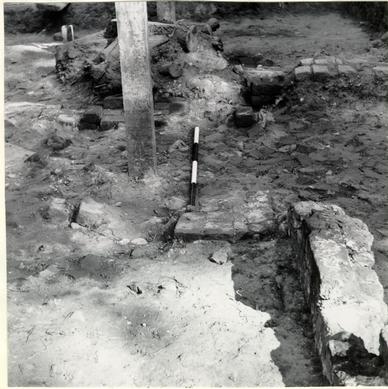
 First period chimney for southeast outbuilding with northeast corner of kitchen in foreground. Photo from west. 68-DB-2965
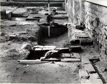
 Detail of northwest corner of first period southeast outbuilding with foundation of north addition passing over first period wall. Photo from west. 68-DB-2966
 First and second period southeast outbuilding with second period chimney in left foreground and second period partition wall between the first and second chimneys. Photo from above, northwest. 68-DB-2967
 Foundation of kitchen after excavation; the dairy foundation is visible in the left foreground. Photo from southwest. 68-DB-2968
 The kitchen chimney with the building's north and south foundations beyond and to the left of it. Photo from south. 68-DB-2969
 Kitchen chimney with foundation of north wall in foreground showing posthole beneath it. Photo from north. 68-DB-2970
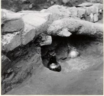 Two wide-necked bottles in situ under north kitchen wall (after removal of central octagonal bottle). Photo from south. 68-DB-2971
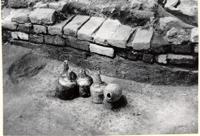 Group of four English and one French wine bottles in pit below, and south of north kitchen wall. Photo from south. 68-DB-2972
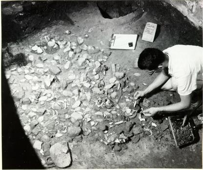
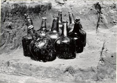 A group of ten wine bottles (c.1740-50) inside northwest corner of kitchen. Photo from west . 68-DB-2973
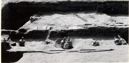 Mid-eighteenth-century wine bottle groups east of dairy foundation. Photo from east. 68-DB-2974
 Southwest outbuilding complex with northwest corner of first period building below water pipe at right extreme foreground. Second period foundation center parallel to water pipe on left. Center foreground northeast corner of third period structure. Photo from north. 68-DB-2989-A
 Northeast corner of third period smokehouse with ranging pole standing in builders' trench. Photo from northeast. 68-DB-2975
 Builders' trench against west foundation of the third period smokehouse; before excavation. Photo from west. 68-DB-2976
 First period southwest outbuilding foundation to left of, and beneath fireboxes. The foundation in the left foreground carried the west wall of the third period structure. Photo from west. 68-DB-2977
 Mid-eighteenth-century trash pit south of smokehouse complex. Photo from southeast. 68-DB-2978
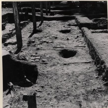
 Nineteenth-century paving over first eighteenth-century well. Photo from northeast. 68-DB-2980
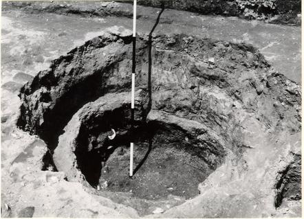
 The first, never completed, well with trash at bottom of filling in situ. Photo from southeast. 68-DB-2981
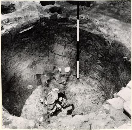
 Second well at an early stage of excavation, with dairy and smokehouse foundation to left of center. Photo above from east. 68-DB-2982
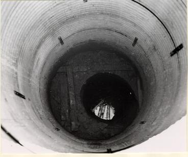
 The second well, in course of excavation, with clay ring standing above inner ash fill. Photo from south. 68-DB-2989
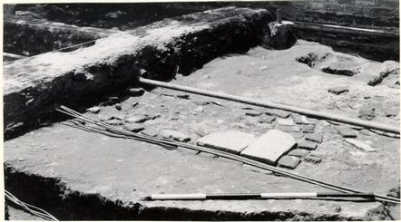
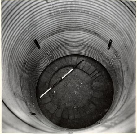 The first surviving course of the eighteenth-century well as revealed below the excavators' steel conduit; the brickwork exposed at initial depth of 15' 3" below modern grade, with V-shaped drain in east face. Photo from south. 66-INH-4044
 The second well after archaeological excavation, with water rising in shaft. Timbers in water had provided footing for excavator working at bottom. Photo from above. 68-DB-2983
 View of head foundation for extant nineteenth-century well. Photo from north. 68-DB-2984
 Nineteenth-century pavement south of tavern and northeast of extant nineteenth-century well. Photo from east. 68-DB-2985
 Shallow trash pit immediately south of the kitchen's southeast corner. Photo from west. 68-DB-2987
 Eighteenth-century walk at southeast corner of southeast addition to first period tavern building. Photo from east. 68-DB-2986
 Eighteenth-century walk south of southeast addition to first period tavern building. Photo from southeast. 68-DB-2988
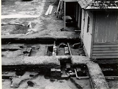
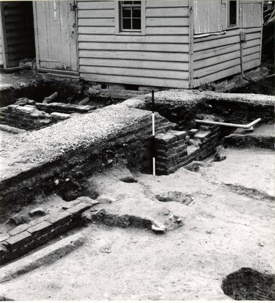
 East tenement west foundation piers adjacent to the east wall of the tavern. Photo from north. 68-DB-2950
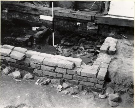
 East tenement chimney, the southeast corner abutting against foundation wall of Charlton Shop, the latter seen in the right foreground. Photo from south. 68-DB-2951
 South addition to the east tenement with rowlock course abutting the foundation of first period tavern's east wall. Photo from north. 68-DB-2949
 Spread of "English" brick beneath east tenement, the principal concentration beyond the east-west ranging pole. Photo from north. 68-DB-2952
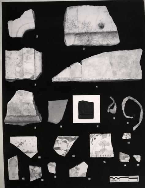 Architectural fragments, marble mantel, weatherboard, lead cames, tile sherds, etc. 67-SMT-170
Figure 46
- 1.Mantel fragment; the interior corner from the top of the fireplace, probably from the mantel of the "Great Room." The stone is white marble with grey-blue veins. Maximum thickness is 1 ¼". ER 1180A.9C.
- 2.Mantel fragment from a vertical (side) slab. The stone is while marble with grey-blue veins. Maximum thickness is 1". ER 1004.9N.
- 3.Mantel fragments (?) of white marble with grey-blue veins. Maximum thickness is 1 3/8". ER 1001.9N.
- 4.Marble fragment. Stone color is dirty white. Finish on one surface only; possibly a flooring slab. Maximum width of border is 3/8". Thickness is 1 5/8". ER 1002C.9N. and ER 102D.9N. [Strata: post 1770]
- 5.Marble fragment. Stone color is dirty white. Finished on both surfaces. Use not known. ER 1022.9N.
- 6.Tile fragment, clay. Used for roofing. Color is salmon. Thickness is ½". ER 1001E.9N.
- 7.Weatherboard with beaded edge. Wood is southern yellow pine. Beading is ½" wide. Thickness is 7/16". ER 1135P.9N. (from well at depth of 24'4 1/2" to 31'6" B.M.G.)
- 8."Turned lead" for glazing. Junction piece with right angle joint. ER 1124Q.9N.
- 9."Turned lead" for glazing. Length is 8 ¾". ER 1066H.9N.
- 10.Tile, delftware, bianco sopra bianco decoration. Opaque white overglaze border with yellow overglaze on blue underglaze decoration; grey ground. Hard, pale buff body. English. Mid-eighteenth century or later. ER 1017A.9N.
- 11.Tile, delftware, bianco sopra bianco decoration. Opaque white overglaze border with overglaze red and yellow on underglaze blue and purple decoration; grey ground. Soft, pale buff body. English. Mid-eighteenth century or later. ER 1047A.9N.
- 12.Tile, delftware. Traces of yellow overglaze on blue underglaze decoration; grey ground. Hard, buff body. ER 1067A.9N.
- 13.Tile, delftware. Overglaze yellow and drab purple manganese on blue underglaze, the decoration including a vase or urn with flowers; pale blue ground. Hard, buff body. ER 1017F.9N.
- 14.Tile, delftware. Corner fragment with dark blue decoration on white ground. Hard, pale pink body. Traces of marking on the back which may be a portion of the number, seven, to indicate the order of placement in a design. ER 1179E.9N.
- 15.Tile, delftware. Dark blue decoration of scene with buildings and trees within a circle on white ground. Hard, buff body. Tile was halved laterally for installation. White mortar of a very fine consistency and no visible oystershell content, adheres to lower edge of the back. The corner design was examined by Louis L. Lipski who identified the three straight lines as a distinctive English pattern. Eighteenth-century. ER 1051B.9N.
- 16.Tile, delftware. Corner design as 15. ER 1182.9C.
- 17.Tile, delftware. Dark blue corner design on pale blue ground. Soft, pale buff body. ER 1040Q.9N.
- 18.Tile, delftware. Edge fragment with manganese decoration on white ground. Soft, pale buff body. Tiles of this type -- with only manganese decoration -- were made primarily by the Dutch with the decoration frequently depicting a scene from the Scriptures. Eighteenth-century or earlier. ER 1033.9N.
- 19.Tile, delftware. Manganese decoration including a portion of a circle on a white ground. Soft, pale buff body. As 18, probably Dutch. Eighteenth-century or earlier. ER 1020K.9N.
December 18, 1968
TO: Mr. C. E. HackettFROM: I. Noël Hume
RE: Wetherburn Tavern Report, Volume I, Part 2
I have pleasure in transmitting herewith a copy of the report on the Wetherburn Tavern site excavation, volume 1, part 2.
When you are through with this copy, would you please pass it to Mr. Buchanan for addition to the architectural library.
I. N. H.