Charlton House Archaeological Report, Block 9 Building 30 Lot 22Originally entitled: "The Charlton Site Block 9 Area P Colonial Lot 22"
Colonial Williamsburg Foundation Library Research Report Series - 1163
Colonial Williamsburg Foundation Library
Williamsburg, Virginia
1990
To: Mr. C. E. Hackett
From: I. Noël Hume
Re: Charlton House Archaeological Report
I have pleasure in submitting herewith Mr. Glenn Kirk's report on the 1966 archaeological work on the above site. This is the copy to be maintained in the Architectural Library, and I shall be grateful if you will pass it to Mr. Buchanan when you have perused it.
I.N.H.
THE CHARLTON SITE
Block 9, Area P
Colonial Lot 22
REPORT OF THE 1966 ARCHAEOLOGICAL FINDINGS
CONTENTS
| Acknowledgments | |
| Introduction | 1 |
| Precis of Lot 22 History | 3 |
| First Period Structure | 14 |
| Second Period Building (The Shop/Office) | 19 |
| The Smokehouse and Well | 31 |
| Yards, Fences, and Drains | 36 |
| Conclusions | 40 |
| Footnotes | 44 |
| Appendix I, Table of brick sizes and mortar composition | 49 |
| Appendix II, Maps and Insurance Policies | 50 |
| Photographs |
| Figure 1. | First Period Building |
| Figure 2. | First and Second Period Buildings |
| Figure 3. | Stratigraphy section from building interior |
| Figure 4. | The Smokehouse and Well area |
| Figure 5. | Well section |
| Figure 6. | Nineteenth-century drains |
| Figure 7. | Tyler's Map of Williamsburg |
| Figure 8. | Frenchman's Map, Charlton area |
| Figure 9-11. | Insurance policies of 1796, 1806, and 1823. |
| Photo. 1. | Overall elevated shot from the south |
| Photo. 2. | Construction spread from first period and second period chimney |
| Photo. 3. | South foundations, both periods |
| Photo. 4. | Second period chimney |
| Photo. 5. | Second period chimney |
| Photo. 6. | Second period front stoop |
| Photo. 7. | Southwest hearth, second period addition |
| Photo. 8. | Rubble and trash layer |
| Photo. 9. | Pier beneath modern smokehouse foundation |
| Photo. 10. | Well |
| Photo. 11. | Bottles and bricks in trench northeast of second period front stoop |
| Photo. 12. | Center 19th century drain, north end |
ACKNOWLEDGEMENTS
Since the Charlton site was only a small portion of the primary excavation at the Wetherburn tavern site, a great many people were directly and indirectly associated with the work of the Department of Archaeology. Without their assistance, a project of this magnitude would have been impossible. In the course of the excavations and the preparation of the report, special aid was provided which must be appropriately noted. Particular appreciation is extended to: the student excavators--Mr. Garry Stone, Mr. Gary Williams, Mr. William Kelso, Mr. Alastair MacDonald, Mr. Geoffrey Moran, and Mr. Stanley Taylor; Miss Mary Stevenson and Mrs. Mary Goodwin, whose research reports were most helpful; Mr. Paul Buchanan, who provided information about architectural and historical matters; Mr. William Hammes, who supplied the references about wig making; Mr. Douglas White and Mr. J. M. Knight, who were responsible for survey data; Mr. Alden Eaton, who directed the landscaping work necessitated by the digging; Mr. Daniel Barber, who prepared the drawings to illustrate the report; and, Mrs. Janet Higdon, who undertook the chore of converting the manuscript into the final report volume.
ARCHAEOLOGICAL EXCAVATIONS ON THE
CHARLTON SITE, COLONIAL LOT 22
Introduction
The report of archaeological findings on the Charlton property, Colonial Lot 22 of Block 9 on the south side of Duke of Gloucester Street, is based on the excavation of the northwest corner of the lot adjoining the Wetherburn site (Colonial Lot 21 of Block 9). The work carried on during the summer of 1965 to the east of the Wetherburn tavern had disclosed the presence of a tenement structure on Lot 21 which abutted a building on Lot 22. With the restoration of the Wetherburn tavern due to begin at the conclusion of 1966, it was considered advisable to complete the archaeological investigation of the structure on Lot 22 at the earliest possible date. The excavation was restricted to the area west of the Charlton house and extending south to the Charlton kitchen, leaving the remaining and larger portion of Lot 22 unexplored. The full excavation of Lot 22 may produce information at a later date which will alter the conclusions of this report.
2As the work in the Charlton area was considered an extension of the Wetherburn project of the summer, 1966, the site was dealt with in that context. The grid was extended from Lot 21 and the excavation work was done by the summer crew which was pursuing the completion of the Wetherburn site. The digging on the Charlton property was started in the latter portion of June and completed by the beginning of September. Some digging was done in the smokehouse and its immediate vicinity while the boardwalk connecting the King's Arms parking lot and Duke of Gloucester Street was closed during May. At that time, the boardwalk had been removed to allow excavation of the east portion of the southeast Wetherburn outbuilding. The total excavation time was slightly over three months with the permanent staff working in May and a portion of the temporary staff working during the summer months.
The investigation was confined to the structure west of the Charlton house thought to be Edward Charlton's barber shop-a matter to be considered at some length-and the yard immediately to the south. No attempt was made to examine the Charlton house proper or the reconstructed kitchen. The foundation of the smokehouse 3 was examined very thoroughly and a well immediately outside the smokehouse entrance was excavated to a depth of 14'3". The time consumed by the work on the well along with the requirements of the Wetherburn site prevented extensive work in the yard excepting a strip about 10'0" wide south of the second period structure's rear wall. The restricted scope of the excavation means that the conclusions which can be drawn will not represent an overall archaeological analysis of the Charlton property. In a sense, the report about the Charlton shop structure is made out of context excepting those considerations of its possible relationship to the Wetherburn site.
Precis of Lot 22 History*
The history of Lot 22 has several very distressing gaps. Records have not been discovered in sufficient quantity to allow the story of the property, particularly during the eighteenth century, to be reconstructed without considerable conjecture. No document or reference establishes initial or early ownership. The early control of the property is assumed to have been in the hands of William Byrd II. In 1707, Byrd purchased Lot 24 from James Shields, a tailor.1 There is no record of a purchase 4 by Byrd of Lots 22 and 23, but his ownership of these two additional lots is strongly suggested by a deed conveying three unnumbered lots on the south side of Duke of Gloucester Street to Alexander & Archibald Buchanan & Company in 1749/50.2 (see Appendix II, fig. 7.) The seller was James Crosby, merchant of Glasgow. The deed specifically names Byrd as the previous owner and provides some helpful information.
"...the said James Crosby for and in Consideration of a certain Sum of Money, the receipt whereof is hereby Acknowledged doth give grant enfeoff and confirm unto the said Andrew Archd Buchanan's & Company... forever Three Lots of Land containing half an Acre in each Lot (upon one of which Lots there is built a Dwelling House & Kitchen upon the Middle Lott is a Storehouse and upon the other Lott there is a Ware house & Stable all lying Contiguous in the City of Williamsburgh on the South side of the Main Street opposite to the Rawley Tavern which said Lots are marked in the Plan of the said City by the Nos [not given] which formerly belonged to the late Colonell William Bird of Charles City County) ... 3As informative as this document is, it does not explicitly identify the lots; it does not indicate when Byrd purchased them or for what purpose; it does not indicate when Crosby obtained them; and in spite of the information about the structures, it does not indicate whether the sequence of buildings is from the east or the west. 5
If Byrd did purchase Lots 22 and 23 at about the same time he acquired Lot 24, there is the possibility that the store which he owned with Richard Bland in 17104 was situated on Lots 22 or 23. At the time of Byrd's purchase, a dwelling house was located on Lot 24.5 Bland owned Lots 20 and 21 and also Lots 53 and 54 on the north side of Duke of Gloucester Street.6 (See Appendix II, fig. 7.) The proximity of the properties could be indicative of a deliberate arrangement for business purposes. The available information about the Byrd-Bland store, however, does not provide any suggestion as to its location. Other than this possibility, the ownership and use of Lots 22 and 23 is not clearly established for the first forty years of the eighteenth century. The transfer of Byrd's three lots to James Crosby is not documented. Crosby was in Williamsburg as early as 1740, for James Bray sold bricks and lumber to a Mr. Crosby, merchant, in that year.7 The location of Crosby is not established even though in 1745 Alexander Finnie advertised merchandise for sale in a location adjacent to Crosby.8 Finnie had not yet purchased the Raleigh and was still a wigmaker, but his location at this date is not known. If the dwelling house were on Lot 24 and the warehouse on Lot 22, Crosby 6 could have rented the store on Lot 23 to Finnie. Likewise, the warehouse on Lot 22 might have been converted to a shop which was rented by Finnie. Without additional documentary information, however, these ideas must be regarded as speculation. The only safe conclusion is that Crosby obtained his three lots prior to 1749/50.
Following the presumed sale of Lot 22 to Buchanan and Company, the question of the lot's ownership and use is clouded again by a lack of definite documentary information. Buchanan and Company appointed John Hyndman as their attorney to dispose of the three lots obtained from Crosby.9 In 1752, Hyndman advertised the lots for sale indicating that he had occupied them.10 In 1753, Lot 24 was sold to Dr. Kenneth McKenzie.11 No record of sale has been found for the other two lots. McKenzie's death forced his widow to mortgage Lot 24 in 1760, at which time John Carter, merchant, is identified as the occupant of the property to the west.12 No lot numbers are specified so it is not clear whether Carter was located on Lot 23 only or on both Lots 22 and 23. There is evidence that John Carter lived on Lot 23 in what became the King's Arms tavern. This information is provided by Jane Vobe's advertisement announcing the opening of the King's Arms in the house recently occupied by John Carter.13 In 1765 7 John Carter and his brother, James, built a divided brick building on the east side of Lot 53.14 (See Appendix II, fig. 7.) James moved the Unicorn's Horn Store into his portion of the house and John moved his store into the other. The relocation of John Carter's store produced no information about Lot 22.
An advertisement by John Carter in 1769 suggests the first association of the Charlton name with Lot 22.15 The advertisement announced Carter's intention of going to England and offered his merchandise for sale. Also included was a note which stated that "The Shop near Mr. Charlton's is to be rented." Carter still lived on Lot 23 at this date and it might be that the shop to be rented was situated on Lot 23 as well. This could locate a Charlton -- Richard or Edward -- on Lot 22. Edward Charlton was in Williamsburg by 1752 when he entered into partnership with Richard Gamble, a barber, located in a shop adjacent to the Raleigh.16 Richard Charlton, a barber and tavern keeper, is mentioned first in a York County law suit for which he was a witness on June 20, 1763.17 While both men were in Williamsburg by 1769, it would seem most likely that Edward rather than Richard was located on Lot 22. Richard advertised in 1767 that "The Coffee-House in this city being now opened by the subscriber as a Tavern" was open for business.18 Since Richard's tavern 8 continued to operate until at least August of 1774 as witnessed by accounts recorded in George Washington's Ledger for that month and year,19 it would seem unusual that Edward Charlton could advertise the property for sale in November of the same year. Edward Charlton not only advertised his house and lot for sale in 1774, but also did so again in 1775, in 1778, and in 1779.20 This property is identified as Lot 22 by a deed of 1784 which indicates that Edward Charlton conveyed Lot 22 to the estate of Richard Charlton shortly after the latter's death in 1779.21 The available documentary evidence clearly suggests that Edward Charlton owned Lot 22 from at least 1774 until 1779 while there is no information to suggest that Richard Charlton's tavern was ever located on Lot 22. John Carter's advertisement, therefore, could imply that Edward Charlton was on Lot 22 by 1769.
The improvements on Lot 22 including the house referred to in Edward Charlton's advertisements have been assumed to be those which Charlton had built. Previous to this time the only structures associated with the property were the warehouse and stable present in 1749/50. The documentary assignment of these structures to Lot 22 is based on only one item of evidence, which is the fact that a dwelling was present on Lot 24 when it was purchased 9 by Byrd in 1707. In the absence of other evidence, it has been presumed that forty years later Lot 24 continued to be the location of the dwelling house. Even if the presumption is accurate, it cannot be assumed that Charlton built the house now occupying Lot 22. It must be remembered that a 20 to 25 year lapse in the history exists for the period from 1749/50 to 1769 or 1774 when Charlton is definitely situated on Lot 22. Charlton undoubtedly lived in a house on the lot as his advertisements indicated, but there is no evidence at this time to identify him as the originator of its construction. Apart from Charlton's advertisements which refer to a house and associated improvements, the only other information about structures in this period is provided by the Frenchman's Map of 1782. (See Appendix II, fig. 8.) The map shows a building in the same location as the existing house. Five outbuildings were situated in the rear yard. The area between the Lot 22 house and Wetherburn's tavern appears to have been occupied by a single structure which archaeology has now revealed to have been two adjoining buildings -- one on Lot 22 and the other on Lot 21. The first specific identification of buildings is provided by an insurance policy dated 1796 which provided coverage for a house, office, and kitchen.22 (See Appendix II, fig. 9.)
10The archaeological excavations disclosed the foundations of a structure to the west of the Charlton house with measurements corresponding to those of the office identified in the insurance policy of 1796 and located in the position indicated by a subsequent policy of 1806.23 (See pp. 19-22 and Appendix II, figs. 9 and 10.) The presence of wig curlers immediately adjacent to and within the area of the office strongly suggests the possibility that it was used by Charlton in the pursuit of his trade as a barber. There is the additional possibility that some of the curlers may have come from the shop of James Martin, a barber who was a tenant on Lot 21 in 1760.24 (See pp. 25-26.) It also was found that the shop/office, and possibly the house, were built over an earlier foundation which might have been for a store or warehouse. The archaeological section of the report will be devoted almost entirely to the association of these findings with the Charlton and pre-Charlton periods.
Following its transfer to the estate of Richard Charlton, Lot 22 was presumedly occupied by Richard's widow, Sarah, and their children until 1795. There is no information about the use of the property or possible occupants of the shop/office for this period between 1779 11 and 1795. Williamsburg Land Tax records show the estate of Richard Charlton charged with one lot from 1785 until 1794.25 In 1795, William Russell is given as owner of a lot via Richard Charlton's estate. Russell's insurance policy of 1796 provided the first documentary mention of the office building and confirmed the lot to be 22 as it was located between the property of Philip Moody and William Rowsey -- the owners by this date of Lots 23 and 21 respectively.26 Russell also owned the property when it was insured in 1806. The reference to an office building may indicate its use by Russell. He served as Clerk of the Eastern State Hospital from 1786 until 1803 and as Clerk of the Hustings Court of Williamsburg from 1783 until 1813.27 He may have maintained his office in the building so described on his property. Following Russell's death, the property passed to his daughter, Catherine, who sold it to Leonard Henley by 1819.28
An insurance policy renewed by Henley in 1823 provides the information that the office had been pulled down.29 (See Appendix II, fig. 11.) The destruction of the office building suggests that it was of no use to Henley due either to its state of disrepair or to the location of his business activities elsewhere or both. It should be pointed out that Henley held both public offices previously held 12 by William Russell. Henley died in 1831.30 The property remained in the full or partial control of Henley heirs until at least 1886. The widow, Harriet Henley, was recorded as owner in 1861. In 1880, the property was ordered sold following a law suit of the Mutual Assurance Society against the heirs of Leonard Henley. It was purchased by R.L. Henley, trustee for Ella J. Henley and children. A default in payment resulted in the sale of the west half of the lot to R.B. Servant in 1886 with the east half of the lot being retained by R.L. Henley.31 The heirs of Servant conveyed the property to Colonial Williamsburg in 1928.32
The chronology of the property clearly reveals the deficiency in documentary information for the colonial period.
| 1707 | Property possibly acquired by William Byrd II. |
| Prior to 1749/50 | James Crosby purchased property from William Byrd II. |
| 1749/50 | Property sold to Buchanan and Company. |
| 1752 | Property advertised for sale by John Hyndman, attorney for Buchanan and company. |
| By 1774 | Edward Charlton owner. |
| 13 | |
| 1784 | Transferred to estate of Richard Charlton by an agreement dated October 1779. |
| 1795 | Property acquired from Richard Charlton estate by William Russell. |
| 1812 | Property inherited by Catherine Russell, daughter of William Russell. |
| 1819 | Property sold to Leonard Henley. |
| 1831 | Property inherited by Harriet Henley. |
| 1861 | Harriet Henley paid taxes on property. |
| 1880 | Heirs of Leonard Henley sued by Mutual Assurance Society. Sale of property ordered. |
The Archaeology of the Charlton Site
First Period Structure
The excavations revealed the presence of foundations for two buildings -- one overlying the other. The first of these was almost eradicated by later construction. The remains of the foundation included only portions of the west and south walls. (See fig. 1 and photo. 1 & 2.) The east wall footings were gone without trace, perhaps as a result of the Charlton house construction. The north wall also was absent, possibly destroyed when the shop/office was built in the area to the west of the Charlton house. Assuming that the first structure and the shop/office had approximately the same north wall line, the first structure would have been 20' 10" deep. Its maximum determinable width was 15' 3". The foundation was made of "English" brick and had a thickness of 11".35 No other features of the building were discovered.
Only two short sections of builders' trench were found for the first period foundation. These sections were against the south face of the south wall.36 The artifacts from the builders' trench suggested that construction was in the second quarter of the eighteenth century. In addition, there was an extensive spread of debris to the west of the building containing many "English" bricks.
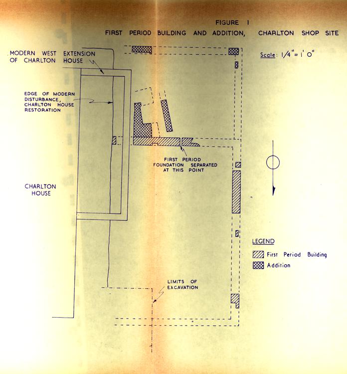 Figure 1
16
(See photo. 2.) This layer, because the bricks bore no evidence of mortar, is assumed to date from the construction of the building. The layer passed beneath the west foundation of the shop/office as well as the foundation of the east tenement on Lot 21. (See photo. 3 & 4.) The artifacts from the debris spread suggest a construction date of about 1740.37 The presence of the building by this date or shortly afterward would be consistent with the historical data which indicates that a warehouse might have stood on Lot 22 in 1749/50.38
Figure 1
16
(See photo. 2.) This layer, because the bricks bore no evidence of mortar, is assumed to date from the construction of the building. The layer passed beneath the west foundation of the shop/office as well as the foundation of the east tenement on Lot 21. (See photo. 3 & 4.) The artifacts from the debris spread suggest a construction date of about 1740.37 The presence of the building by this date or shortly afterward would be consistent with the historical data which indicates that a warehouse might have stood on Lot 22 in 1749/50.38
The first building was expanded by an addition at the rear, increasing the depth of the structure by 10' 0". Traces of the addition foundation were found south of the first period southwest corner and about 12' 0" to the east along the line of the new south wall. (See fig. 1 and photo. 5.) The absence of any other evidence for the foundation gives rise to the possibility that the appendage may have stood on piers. A chimney was built in the new rear room. It was located 10' 9" east of the southwest corner of the first building. One cheek abutted the south wall of the first building with the fireplace facing the west wall and southwest corner of the addition. It appeared that the chimney had been in the corner of a room. No evidence was found to indicate whether the chimney had 17 abutted the east wall of the addition or a partition wall of another rear room to the east. The chimney footings had been damaged by the construction of the west extension of the Charlton house. Projections based on the remaining portions of brickwork suggest that the front of the chimney would have been approximately 6' 6" wide. The fireplace would have been approximately 3' 3" wide at the mouth and about l' 9" deep. The actual width at the back was 2' 6". The hearth extended 1'8" beyond the mouth and had a border of bricks 8"-9" wide. The date of the addition is suggested by a fragment of creamware found among the bricks of its foundation at the southwest corner.39 Creamware does not appear to be common in Williamsburg until about 1769.40 As subsequent consideration of the destruction date of the first period building and the construction of the shop/office will show, the addition may have to be regarded as probably earlier.
The destruction of the first period building and its rear addition coupled with subsequent construction left only minute traces of stratigraphy from which the demise of the building could be dated. These were confined to deposits immediately over the remaining portions of the west foundation.41 The south foundation was reused 18 by the shop/office structure while the and east foundations were entirely destroyed. No general spread of debris was discovered which could be unquestionably identified as destruction of the first period. The absence of extensive debris might indicate that the building was moved away rather than being dismantled. Of the four deposits immediately over the west foundation, two contained artifacts which would date 1790 or later.42 In both instances, a modern utility trench had previously exposed these portions of the west foundation and could account for the presence of the late artifacts. The other two deposits produced objects generally datable to about mid-eighteenth century, but without clearly defined limits.43 The date for the destruction of the first period building, however, does seem to be definitely linked with the construction of the shop/office. This is seen in the stratigraphy running east to west across the front portion of the site. (See fig. 3.) The brown subsoil is immediately below a layer of rubble and trash which was sealed in turn by a layer of plaster and then a layer of brick rubble and shell. All three of these layers give evidence of association with the shop/office which leaves no intervening stratigraphy representing either the destruction of the first period building or 19 an accumulation which could have been deposited after the destruction of the first building and before the construction of the shop/office.44 The destruction of the first period, therefore, would appear to have been quickly followed by the construction of the shop/office.
Apart from the remaining portions of the foundations, little information was obtained about the character or use of the building. The absence of a chimney in the original structure and the inclusion of one in the addition might be indicative of a change in the use of the building, but no other evidence was found which could confirm this possibility. No objects were recovered which would suggest anything about the appearance or structural nature of the building.
Second Period-Building (The Shop/office)
The second building occupying the area to the west of the Charlton house on Lot 22 overlay the west portion of the first building. (See fig. 2 and photo. 1.) The foundations had suffered damage on all four sides, but the remaining sections were sufficient to provide much of the essential information about the size and character of the structure. The depth of the building was 30' 0" and its width, 26' 0". The front two-thirds was separated
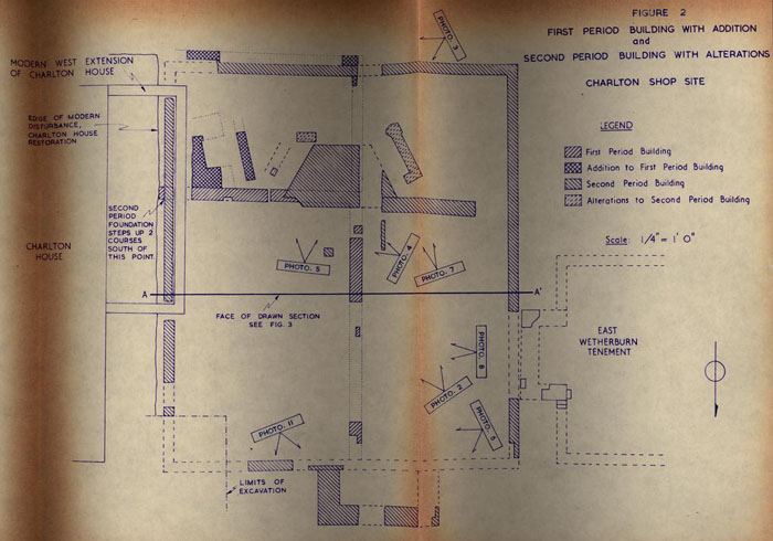 FIGURE 2 - Plan
21
from the rear portion by a large chimney located 19' 6" south of the front wall. The chimney was built over a portion of the first period building's south footings while another section of the earlier foundation appeared to have been reused as a part of the second period structure. This was indicated by its survival from the east second period foundation wall to the chimney and by the construction, in the second period, of a corresponding foundation west from the chimney to a point 2' 3" from the west second period foundation wall. While the presence of the chimney and its flanking wall foundations indicate a division of the building, other evidence is available to suggest not only a division, but also the possibility that the rear portion may have been structurally different. South from the junction of the east second period foundation with the south first period foundation, the second period foundation steps up two courses. This might suggest a lighter form of structure for the rear. It does not point to an addition, however, as both the east and west foundations were bonded straight through. The insurance policy of 1806 describes an office with a shed in this location, but the 1796 policy makes no mention of a shed. (See Appendix II, fig. 9 & 10.) In both instances the dimensions of the building are the same as the overall
22
size of the second period structure. The implication would seem to be that the portion of the building south of the chimney was initially built in the form of a shed rather than a continuation of the structural form of the front (north) portion.
FIGURE 2 - Plan
21
from the rear portion by a large chimney located 19' 6" south of the front wall. The chimney was built over a portion of the first period building's south footings while another section of the earlier foundation appeared to have been reused as a part of the second period structure. This was indicated by its survival from the east second period foundation wall to the chimney and by the construction, in the second period, of a corresponding foundation west from the chimney to a point 2' 3" from the west second period foundation wall. While the presence of the chimney and its flanking wall foundations indicate a division of the building, other evidence is available to suggest not only a division, but also the possibility that the rear portion may have been structurally different. South from the junction of the east second period foundation with the south first period foundation, the second period foundation steps up two courses. This might suggest a lighter form of structure for the rear. It does not point to an addition, however, as both the east and west foundations were bonded straight through. The insurance policy of 1806 describes an office with a shed in this location, but the 1796 policy makes no mention of a shed. (See Appendix II, fig. 9 & 10.) In both instances the dimensions of the building are the same as the overall
22
size of the second period structure. The implication would seem to be that the portion of the building south of the chimney was initially built in the form of a shed rather than a continuation of the structural form of the front (north) portion.
The chimney of the second building was rather substantial. (See photo. 3, 4, & 5.) Its foundation was 8' 6" wide at the front and approximately 3' 3" wide at the back. It was 4' 9" deep. Six courses of brickwork survived. The bottom four were laid in a regular manner while the upper two courses were set in a curved arrangement which might suggest that there could have been some sort of oven instead of a fireplace. (See photo. 5.) The purpose for an oven in the building is uncertain, but if the building served as a barber shop for Edward Charlton, there is the possibility that it might have been used for preparing wigs. Precedent for an oven in a barber shop is provided by two sources, Diderot's Encyclopedia of 1771 and a book about wig making by Mons. de Garsault, first published in 1767. In describing the equipment required Diderot states:
"A drying oven is also necessary. There are both round and square ones. Those that have the land can have the oven made of masonry, like a furnace."4523 The process of preparing hair for use in a wig was described by both Diderot and Garsault as involving the use of the oven for drying hair after it was boiled and for baking it in a "loaf".46 In the latter process, hair was wrapped in paper which was covered by dough with the package or "loaf" then cooked in an oven. Each writer mentions that the "loaf" could be carried to the "gingerbread maker" who would prepare the dough and bake the "loaf" in his oven. The association of the curved brickwork of the chimney foundation with an oven would appear to be consistent with evidence that Charlton apparently pursued his trade as a barber in this building.
Other structural features of the building included the foundation of a front stoop, a pier, and a short section of footing north of the chimney near the pier. The front stoop foundation was built primarily of brick bats. (See fig. 2 and photo. 6.) It was 9' 0" wide and 4' 2" deep. The stoop was positioned off center to the front of the building, being 5' 9" from the northwest corner and 11' 3" from the northeast corner. Its north footing was 1'5" thick while the east footing was 1'7" thick. The west portion had been damaged by a modern utility trench precluding any measurement of thickness. While no 24 evidence of steps was found, a deposit of sandy wash was discovered parallel to the north face of the foundation.47 The presence of this deposit could indicate that water had flowed beneath the steps which might mean they were built of wood. While the stoop foundation was easily identified, the pier and short section of footing located just north of the chimney had a less evident structural purpose. (See fig. 2 and photo. 2.) The pier was 9" square and 3' 0" north of the chimney. The section of footing was 3' 8" west of the pier and 5" north of the chimney. It was 3' 0" long running north and south with its east edge cut through by a modern utility trench leaving only a 4" width standing. Though their function is uncertain, the pier and footing may have provided extra support for the floor adjoining the front of the chimney.
A layer of sandy wash at the southwest corner of the building and predating its construction contained an artifact which provides a terminus post quem for construction.48 The artifact was a fragment from a saltglaze plate saluting the King of Prussia, an ally of England during the Seven Years' War. These plates were produced for the period 1757-1763. The construction of the building must date after 1757. The only builders' trenches related to 25 the second period foundations were adjacent to the chimney. Artifacts from these trenches could be consistent with construction as late as 1770 or shortly thereafter.49 Similar dating evidence was provided by artifacts in a layer of sandy wash50 passing beneath the south foundation east of the southwest corner. When combined, the evidence would seem to indicate that construction occurred after 1757 and possibly as late as the early 1770's. This also can be taken to mean that the first period building probably disappeared from the site prior to this period, i.e., immediately prior to the second period construction. (See pp. 17-19.)
The presence of wig curlers in the vicinity of the second building suggests that this was the site of Edward Charlton's barber shop. Charlton owned Lot 22 from at least 1774 until 1779. Many of the wig curlers were found in contexts which date after the period of Charlton's ownership.51 As the building had a wooden floor, little stratigraphy was found which could be regarded as common only to the Charlton period. one wig curler was contained in the rubble and trash which may have been deposited below the floor during the life of the building, but the layer also contained artifacts dating after Charlton. 26 Layers to the west of the building were subject to disturbance which could account for some wig curlers appearing in contexts of a later date. Full excavation of the yard areas to the south may provide additional evidence from deposits more closely associated with the Charlton period. The presence of the wig curlers inside the area of the building and in areas closely adjoining the building and the ownership of the property by Edward Charlton, who was a barber, must be taken into account when the use of the building is considered.
While no evidence was found to suggest that a shed addition was built at the rear after initial construction, brickwork was found in the rear area of the building which indicated some modification at a later date. The brick-work was located on both sides of the chimney and, though that portion to the east was almost destroyed, the west portion suggested that hearths had been added for the rear area. (See Photo.7.) At the southeast corner of the chimney, a short one course footing extended to the east parallel with the south face of the chimney. It was not clear whether this was a part of the east hearth. The brickwork of the west hearth was laid over a layer of broken plaster and brick52 which might have been deposited when the modifications were being made. Contained in the 27 layer was a fragment of hand-painted pearl ware of the period 1790-1810. The footing at the southeast corner of the chimney was over the builders' trench for the chimney and over a layer of plaster53 at its eastern end which produced artifacts dating to at least 1760. The possibility exists that this section of brickwork was a part of the initial construction sequence, but not until after the chimney was built, or at least partially completed.
The stratigraphy midway between the north wall and the chimney provided a reasonably defined sequence for the building up to and including its destruction. (See fig. 3.) Immediately over the subsoil and the construction spread from the first period building was a layer of rubble and trash which may have accumulated during the life of the building. (See photo. 8.) Above the rubble and trash was a layer of broken plaster which may have been deposited during renovation of the building or at the time of dismantling. The plaster was covered in turn by a layer of brick rubble which represents the destruction of the building. The presence of shells in this layer could indicate that it subsequently served as a yard surface. The presence of the rubble and trash layer raises the question of how these materials might have been deposited under
 FIGURE 3 - Section Drawing - oversized image
29
the building and its floor. The foundation enclosed the entire area and there was no indication that an opening had been created through which the artifacts could have been thrown. Cracks in the flooring would allow small objects to drop through, but not brick bats or good size ceramic sherds. The bricks could be accounted for by the possibility that they might represent construction debris dropped in the course of building the foundations and chimney prior to the completion of the floor. The dating of the artifacts suggests another possible explanation. A terminus post quem for the layer was provided by a Liberty head (with cap) half cent piece.54 While the date is not distinguishable, the coins of this particular design were minted in only the years of 1795, 1796, and 1797.55 The earlier date -- 1795 -- would have to be considered the terminus post quem. The layer contained numerous sherds of shell-edged pearl ware dating after 1785 and hand-painted pearl ware dating after 1790.56 Creamware sherds of a comparable date were found. As these dates are all well after the initial construction period and since nothing indicated that they had been thrown under the building from the outside, the implication could be that the floor or a portion of it was removed or opened to allow the objects to be deposited.
30
It should be noted that one year after William Russell's purchase of the property in 1795, the building was described as an office rather than a shop. In order to use the structure as an office some modification may have been required either at the time of purchase or afterward. However, there is no information as to whether Russell used the office nor about the type of business which might have been conducted in the building. The addition of the hearths in the rear area might be another phase of turning a shop into an office.
FIGURE 3 - Section Drawing - oversized image
29
the building and its floor. The foundation enclosed the entire area and there was no indication that an opening had been created through which the artifacts could have been thrown. Cracks in the flooring would allow small objects to drop through, but not brick bats or good size ceramic sherds. The bricks could be accounted for by the possibility that they might represent construction debris dropped in the course of building the foundations and chimney prior to the completion of the floor. The dating of the artifacts suggests another possible explanation. A terminus post quem for the layer was provided by a Liberty head (with cap) half cent piece.54 While the date is not distinguishable, the coins of this particular design were minted in only the years of 1795, 1796, and 1797.55 The earlier date -- 1795 -- would have to be considered the terminus post quem. The layer contained numerous sherds of shell-edged pearl ware dating after 1785 and hand-painted pearl ware dating after 1790.56 Creamware sherds of a comparable date were found. As these dates are all well after the initial construction period and since nothing indicated that they had been thrown under the building from the outside, the implication could be that the floor or a portion of it was removed or opened to allow the objects to be deposited.
30
It should be noted that one year after William Russell's purchase of the property in 1795, the building was described as an office rather than a shop. In order to use the structure as an office some modification may have been required either at the time of purchase or afterward. However, there is no information as to whether Russell used the office nor about the type of business which might have been conducted in the building. The addition of the hearths in the rear area might be another phase of turning a shop into an office.
The plaster layer immediately over the rubble and trash could also represent renewal of the structure. This layer57 contained a Liberty head (with cap) one cent piece of the design issued in 1795 and 1796.58 The date was not legible, but the coin does provide a terminus post quem of 1795. The other artifacts were comparable in date to those found in the rubble and trash layer.59 The brick rubble with shells deposited on the plaster produced sherds of blue transfer-printed pearl ware which date from the period 1810-1820.60 The absence of similarly dated items in the plaster would seem to suggest that it was not deposited at the same time. However, only the date of the brick rubble indicates the destruction 31 period. A comparable date of 1810-1820was suggested by artifacts in the rubble debris around the chimney.61 This information links with the documentary information that Leonard Henley purchased the property in 1819 and that his insurance policy of 1823 states the office had been pulled down.
The Smokehouse and Well
The restoration of Lot 22 included the reconstruction of a smokehouse north of the kitchen near the west property line. The areas on three sides (east, north, and west) of this reconstructed building, as well as the area inside, were explored. A most notable discovery was the absence of early brickwork which would have indicated that a colonial smokehouse had previously stood where the reconstructed building is now situated. The smokehouse was found to have been built over layers containing late eighteenth- to early nineteenth-century artifacts, including many fragments of broken wine bottles.62 The modern foundation did pass over an earlier brick pier at the northeast corner, but the pier did not give evidence of association with a building extending to the south. (See fig. 4 and photo. 9.) A layer of brown loam passing beneath the pier and extending to the north contained sherds
FIGURE 4 - Smokehouse and Well - oversized image
33
of delftware which mended with sherds from the same object found in the late eighteenth - early nineteenth century deposits inside the smokehouse.63 Further excavation will be required to complete the examination of the pier and to obtain additional information about a section of brickwork found 3' 6" north of the smokehouse. (See fig. 4.)
The discovery of an abandoned well almost directly in front of the doorway at the east side of the smokehouse was significant evidence that the reconstructed building is not properly located. (See fig. 4.) The excavation of the well made possible a determination of the date after which it had been abandoned, but did not provide information about its construction date. The condition of the well lining was rather curious in that it rose to within 5' 8" of the modern grade on the north side, but had been removed to a depth of more than 13' 01' on the south side. (See photo. 10.) It would appear that an attempt had been made to repair or replace the lining to the south. There was an enlargement of the shaft to the south which indicated the removal of the brickwork was accompanied by some excavation outside the lining. At 13' 0" below modern grade, a slope of clay from the south face of the shaft passed over the south line of the brickwork -- sealing the well. The clay slope reached the north face of the 34 brick lining at a depth of 14' 3" below modern grade. (See fig. 5.) The manner in which the clay sloped into the well shaft strongly suggested that the face of the excavation outside the south well lining had collapsed. The cave-in apparently ended the attempt to repair the well. The latter conclusion is based on study of the artifacts discovered in the fill dumped into the shaft above the clay slope. Numerous sherds of flown blue ware plates were found in the fill. These fragments mended together in a fashion which indicated sherds from the same plates were present in the layers from top to bottom.64 As a consequence, all of the layers can be regarded as contemporary with each other. A flying eagle penny dated 1858 recovered in the top layer thus provides a terminus post quem for the fill.65
The brick lining of the well was built of bricks measuring
7 ¾" x 4 ¾" x 3 ¾" x 2 7/8". The diameter of the shaft was 4' 0". Thirty-seven bricks were required to complete one course of full circumference. The face of the shaft to the north was worn. (See photo. 9.) The excavation of the well was halted at the level of the clay slope due to the danger of going deeper with only a portion of the lining standing and due to the date of abandonment.
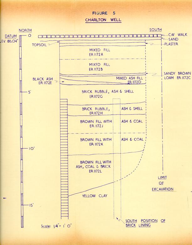 FIGURE 5 - Charlton Well
36
Since the well apparently was used until about 1858, it would have been cleaned many times if it had been built initially during the colonial period. The cleaning would have removed evidence of the earlier period making it most unlikely that pertinent information would have been obtained by further excavation.
FIGURE 5 - Charlton Well
36
Since the well apparently was used until about 1858, it would have been cleaned many times if it had been built initially during the colonial period. The cleaning would have removed evidence of the earlier period making it most unlikely that pertinent information would have been obtained by further excavation.
Yards, Fences, and Drains
To the south of the second period shop/office building were at least two yard layers identifiable with the period of its life -- one of shell and the other of marl. A later shell yard was found postdating the destruction of the building and passing over the south foundation wall.66 A second and lower shell yard extended south from the south foundation wall.67 The artifacts from the latter would date until at least 1760, but none after about 1770. This would indicate that it was associated with the very early life of the building. Significantly, wig curlers were found in the surface of this yard.68 A layer of marl was deposited immediately below the shell layer and contained sherds of a Chinese porcelain bowl which mended to sherds of the same bowl found in the shell.69 The other artifacts from the marl were of the same date as those from the shell. Very fragmentary 37 remains were discovered of brick paving which postdated the shell yard. It was not possible to determine the extent or exact nature-of the pavement because of its condition and the limited scope of the excavation in the yard. The artifacts from the brick pavement and the ash layer it sealed included sherds of early creamware of about 1770. Wig curlers had also been deposited in both.70 East from the northeast corner of the front stoop foundation, an unexplained slot or trench had been dug parallel to the street. Sealed beneath the nineteenth-century drain and inside the slot was a row of laid brick bats on which a row of wine bottle bottoms had been placed. (See photo. 11.) The clay fill of the trench contained hand-painted pearl ware of 1790-1810.71 While the bricks might be the south edge of a Duke of Gloucester sidewalk, there is no apparent explanation for the presence of the wine bottle bottoms.
Evidence was found for fence lines related to the first and second period buildings at their southwest corners. In each case, only two post holes were found. For the first period building the post holes extended south from the southwest corner of its rear addition.72 (See fig. 4 and photo. 1.) The artifacts from the fill of the holes dates in the 1740's. The post holes extending south from the-southwest corner of the second 38 period contained artifacts comparable to that of the shell and marl yards.73 The southernmost post hole (ER 10540) contained a wig curler. Additional excavation of the yard area might provide more information about the fences, but it should be noted that in both cases the extensions of the fenceline run directly into areas disturbed during the nineteenth and twentieth centuries.
Portions of four drains were found in the Charlton area. The first was discovered at the southwest corner of the smokehouse and extended south along the outside face of the kitchen foundation. (See fig. 4) It terminated near the southwest corner of the kitchen. The drain was made of brick. Artifacts taken from the layer sealing the bricks date to the end of the eighteenth century.74 Further excavation will be required to determine the possible relationship of the drain to the kitchen. The other three drains postdated the second period building passing over the foundation remains or partially cutting through them. (See fig. 6.) The drains were roughly parallel, running north from the area south of the building toward Duke of Gloucester Street. (See photo. 5 & 11.) It may be that the drains were necessary as a result of the dismantling of the shop/office building. Built of shell and
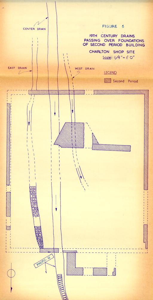 FIGURE 6 - 19th Century Drains
40
brick, the drains were partially cut into brick rubble or passed over the debris spread from the second building. The artifacts removed from the fill of the drains dated from the period of the building's destruction into the second quarter of the nineteenth century, but the later artifacts were relatively few in number.75
FIGURE 6 - 19th Century Drains
40
brick, the drains were partially cut into brick rubble or passed over the debris spread from the second building. The artifacts removed from the fill of the drains dated from the period of the building's destruction into the second quarter of the nineteenth century, but the later artifacts were relatively few in number.75
Conclusions
The findings presented in the report were from a small portion of the full Charlton lot and pending further excavation they must be regarded as incomplete with respect to the entire property involved. The excavations did provide considerable information about the two buildings which were located in the northwest corner of the lot. The first building predated the Charlton ownership. The second building was owned and used by Charlton, if not built at his order. Some information was discovered about nineteenth-century activities on the lot including the abandonment of a well.
The first period building was constructed in the 1740's at a time when no definite barrier existed between Lots 21 and 22. Construction debris spread across the property line onto Lot 21. The initial building was probably the warehouse identified when the property was sold 41 in 1749/1750. It was expanded by an addition at the rear which included a chimney. This may indicate a change in the building's use. The date of the addition appears to be in the 1760's which seems rather late, in that the building was moved or dismantled just prior to the construction of the second building between 1757 and 1770.
The second building corresponds in size to an office identified in insurance policies of 1796 and 1806. Its construction and presence during the Charlton ownership and the discovery of numerous wig curlers in the yard layers and destruction debris point to its use as a barber shop by Charlton. During the last decade of the eighteenth century or early in the nineteenth century the rear room was provided with what appear to be hearths. This change may have come when the building ceased to be a shop and became an office. The structural features of the building pointed to lighter form for the rear portion which would satisfy the descriptions in the insurance policies. The dating evidence from the destruction debris indicated that the building was pulled down about the time Leonard Henley obtained the property in 1819 or shortly afterward. This corresponds to the 1823 insurance policy which states the office had been pulled down.
42No evidence was found to indicate that a colonial smokehouse stood on the spot now occupied by a reconstructed outbuilding. Late eighteenth-century debris and trash were found in the area, but this did not constitute positive evidence for a colonial structure. A pier and section of brickwork were discovered in this area, but further excavation will be required before their character can be thoroughly studied.
The well found just east of the extant smokehouse was abandoned after 1858 when an apparent attempt to repair the lining failed. The late date of the materials found in the fill and the danger created by the presence of a partial lining forced termination of the excavation at a depth of 14' 3". It was at this depth that evidence was found to suggest that the clay of the exposed face of the shaft had collapsed during the repair operation resulting in the abandonment of the well.
South of the second period building, evidence for several types of yard was found. A nineteenth-century shell yard postdated the building. A second shell yard and a marl layer immediately below date to the first years of the second building. Fragments of brick pavement without directional pattern appear to be contemporary with the Charlton period of ownership.
43Post holes appeared to indicate that fences had extended south from the southwest corners of both the first period building with its addition and the second period building. The extent of the fences was not determined due to the limited scope of the excavations. Later excavation may provide further information.
A drain containing late eighteenth-century artifacts was found along the west side of the kitchen building. Aside from the limited dating evidence found on it no further information was obtained. Three nineteenth-century drains were found passing across the location of the second period building and suggested that drainage problems might have been created as a result of the dismantling of the second building.
Footnotes
APPENDIX I
| Location | Measurements | Color |
|---|---|---|
| First Period Building, | 7-3/8 x 3-½ x 2" | Purple |
| wall [ER 1153X] | 7-¼ x 3-½ x 1-7/8" | Purple |
| First Period Building, | 8-7/8 x 4-1/8 x 2-7/8" | Purplish red |
| add. hearth [ER 1156E] | 8-½ x 4 x 2-7/8" | Rich red |
| Second Period Building, | 8-½ x 4 x 2-¾" | Rich red |
| wall [ER 1153W] | 8-½ x 4 x 2-¾" | Reddish orange |
| Second Period Building, | 8-½ x 4-¼ x 2-7/8" | Rich red |
| chimney [ER 1147W] | 8-½ x 3-7/8 x 2-¾" | Purple |
| 9 x 4-1/8 x 2-5/8" | Purplish red | |
| Second Period Building, | 8-1/8 x 3-7/8 x 2-7/8" | Purplish red |
| front stoop [ER 1153V] | 8-5/8 x 4-1/8 x 2-¾" | Purple |
| Well Lining | 7-¾ x (4-¾ x 3-7/8) x 2-¾" | Rich red |
| Location | Composition | Color |
|---|---|---|
| First Period Building, | fine oystershell and sand | White to buff |
| wall [ER 1153X] | ||
| First Period Building, | occasional large pieces of | White |
| add. hearth [ER 1156E] | oystershell, coarse | |
| Second Period Building, | medium oystershell, fine | White to buff |
| wall [ER 1153W] | sand | |
| Second Period Building, | medium oystershell | White |
| chimney [ER 1147W] | ||
| Second Period Building, | fine oystershell and sand | White to buff |
| front stoop [ER 1153X] |
APPENDIX II
FIGURE 7 - Tyler's Map of Williamsburg Early nineteenth century.
Fig.8. - Detail of Frenchman's Map (1782) showing Wetherburn's tavern in relation to the Charlton barber shop (arrowed) and other adjacent buildings.
Mutual Assurance Society
Policy #122
1790, April 22nd.
I the underwritten William Russel residing at Williamsburg in the county of York do hereby declare for Assurance in the Mutual Assurance Society against Fire on Buildings...
My wooden Buildings on the main Street at Williamsburg now occupied by myself situated between the lots of Philip Moody and the lot of Wm Rowseys in the county of York...
| The dwelling house | marked A at | 1000 Dollars |
| The Office | do B at | 150 do |
| The Kitchen | do C at | 140 do |
| 1290 do |
FIGURE 9
Line Drawing (1796, April 22)
Mutual Assurance Society
Policy #618
[illegible], March 11th
A valuation of Buildings insured numbered Declaration No 122 as per Endorsements
I the underwritten William Russell residing at Williamsburg in the county of York do hereby declare for Assurance in the Mutual Assurance Society against Fire on Buildings... My three Buildings on the Main street in the Town aforesaid now occupied by myself situated between the Lotts of William Rowsey on the West and Philip Moody on the East...
| The Dwelling House | marked A at | 3330 Dollars |
| The Office | B at | 400 |
| The Kitchen | C at | 250 |
APPENDIX II - FIGURE 10
Line Drawing (18- , March 11)
Mutual Assurance Society
Policy #5029
1823 May 18th
Revaluation of Buildings formerly declared for Assurance by William Russell per Declaration No. 618
I the underwritten Leonard Henley residing at Williamsburg in the county of York do hereby declare for Assurance in the Mutual Assurance Society against fire on buildings... My buildings on the main street in Williamsburg now occupied by myself situated between the lot of William McCandlish on the East, Francis Powell's lot on the West, and Streets otherwise in the county of York...
| The Dwelling | marked A at | 2500 Dollars |
| The Kitchen | B at | 200 |
| The (Office pulled down) | ||
| $2700 |
APPENDIX II - FIGURE 11
Line Drawing (1823, May 18)
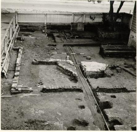 Photo. 1. Second period south foundation with southwest corner of first period addition to right of utility trench. Second period chimney with later southwest hearth in center. West foundation of first period building below range pole. Photo elevated, from the south. 67-INH-534.
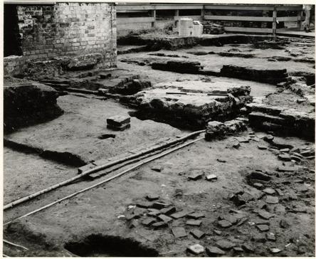 Photo. 2. First period construction spread in right foreground. First period west wall below electric cable center. Second period chimney center. First period south foundation to left of chimney foundation. Photo from northwest. 67-INH-537.
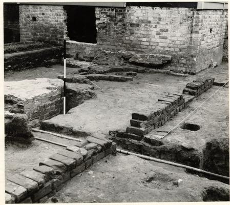 Photo. 3. Second period south foundation with first period addition south wall line marked by string. Second period chimney left center. Chimney of first period addition against Charlton house foundation. Photo from westsouthwest. 67-INH-540.
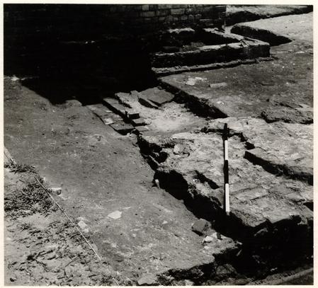 Photo. 4. Front (north) portion of second period chimney, right foreground. South foundation of first period building above and left of chimney. Photo from the west-northwest. 67-INH-542.
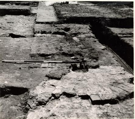 Photo. 5. Rear (south) portion of second period chimney showing curved brickwork of possible oven in center foreground. West nineteenth century brick drain above chimney passing over south second period foundation. Line of center nineteenth-century drain left edge of chimney. Photo from the north. 67-INH-536.
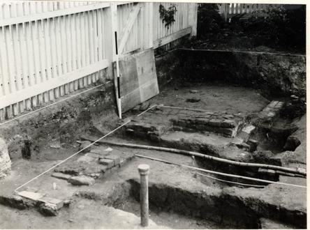 Photo. 6. Front stoop of second period building with front edge shown by string. North end of first period west foundation below electric cable at right edge. Post holes of nineteenth-century fence cut through north foundation of second period building. Photo from the west-southwest. 67-INH-539.
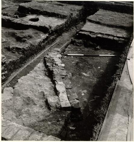 Photo. 7. Hearth added to second period chimney on southwest side. South foundation of second period in background. Photo from the north-northwest. 67-INH-541.
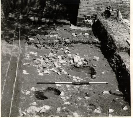 Photo. 8. Rubble and trash layer in foreground. East nineteenth-century drain over rubble and trash layer. East foundation of second period building in background. Photo from the west. 67-INH-535.
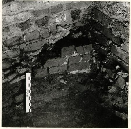 Photo. 9. Late eighteenth-, early nineteenth-century brick pier protruding from beneath northeast corner of modern smokehouse foundation. Wine bottle neck in center deposited in brown loam layer passing below and predating pier. Interior photograph, from the south-southwest. 67-INH-538.
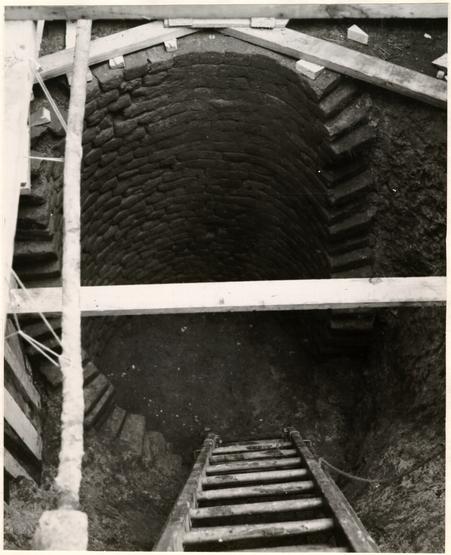 Photo. 10. North face of brick lining for well showing worn surface of pull line to right. Photo from the south. 67-INH-543.
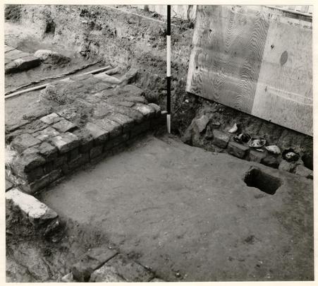 Photo. 11. Slot or trench containing row of wine bottle bottoms resting on row of brick bats to right of range pole below plywood. Northeast corner second period front stoop immediately left of range pole. North foundation wall of second period building in left foreground. Photo from the southeast. 67-INH-544.
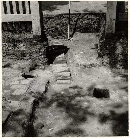 Photo. 12. Brick floor of center nineteenth-century drain to left and below range pole. Northeast corner of second period front stoop left foreground. Modern Duke of Gloucester sidewalk in background. Photo from the south. 67-INH-545.