Alexander Purdie House Archaeological Report, Block 9 Building 28A Lot 24Originally entitled: "Archaeological Report: Purdie's Dwelling,
Block 9, Area A, Colonial Lot 24"
Colonial Williamsburg Foundation Library Research Report Series - 1148
Colonial Williamsburg Foundation Library
Williamsburg, Virginia
1990
CONTENTS
| Archaeological Report of H. S. Ragland | |
| "Macon Lot and King's Arms Tavern." February 1, 1933 | |
| Chronological Summary | |
| General Description | |
| The Early Dwelling | |
| Purdie's Dwelling | |
| The Outbuildings | |
| Sources | |
| Insurance Policy 968 | |
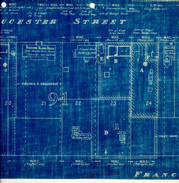
| Section of Archaeological Key Map, showing Areas A and F in relation to surrounding areas. | |
| Archaeological Drawing Block 9, Area A, August 4, 1932 | |
| Archaeological Drawing Block 9, Area F, March 8, 1941 | |
| "Comparative Study of Properties," | |
| Block 9, Areas A-B-E-F | |
| Architectural Drawing TGL 2.3.41 |
Areas A & B TO: H. R. Shurtleff, Director of Research and Record Department
FROM: H. S. Ragland
SUBJECT: ARCHAEOLOGICAL REPORT FOUNDATIONS MACON LOT AND KING'S ARMS TAVERN.
DATE: Williamsburg, Virginia, February 1, 1933
Submitted herewith are archaeological drawings showing the above mentioned foundations.
In the front part of the Macon lot (a part of Colonial Lot #24) at the site of the recently removed Macon House and the supposed site of the earlier King's Arms barber shop, no colonial foundations were found. In fact, nothing was found except a few fragments of interior walls of the Macon House which were not removed when the building was razed by Williamsburg Holding Corporation.
Several small foundations (old, but of undetermined date) built largely of bats laid in oyster shell mortar, were found in the rear part of the lot. Only a course or two exists in each wall, so no bond could be determined. A well was also found, but not excavated.
Between the site of the Macon House and the present Servient House a colonial foundation was uncovered, which apparently is the foundation of the King's Arms Tavern. The dimensions agree fairly closely with the measurements of that building recorded in the old Mutual Assurance Society fire insurance policies issued to Philip Moody in 1796 and 1806, and the site is the same…Colonial Lot #23.
Walls 1, 2, 3 and 4, built of "Palace" size bricks, laid in English bond, enclose the deepest cellar uncovered by excavation in Williamsburg to date. Remains of an arch springing from walls 1 and 3 show that the cellar had a barrel vaulted ceiling. (See plan, sections and elevations.)
Section A A shows the layers of material excavated…about 2½ feet of earth fill, 1½ feet of brick and plaster debris, and about 1 foot of ashes, covering fragments of brick paving. Below the paving a fill of clay, 4 feet deep, was excavated and below that about 2 feet of brick debris. The original undisturbed clay was found level with the bottoms of the walls about 11 feet below the surface.
As no ashes, plaster, or other material was found in the bottom layer of brick debris, it evidently is the remains of the fallen vaulted ceiling. Instead of rebuilding it the debris from it was left where it fell, two brick piers were built on it and a clay fill was made raising the basement floor to the elevation of the paving found about 5 feet below the surface.
Walls 5, 6 and 7 are evidently foundations of an addition to the original building, for the foundation is not bonded to wall 4 and the 2 bricks are smaller (See sizes, bond, etc. on drawing). However, this addition was evidently built prior to 1796, for the foundation not only looks very old but it is necessary to add its dimensions to those of the original foundation to even approximately check the measurements of the front portion of the building, recorded in the insurance policy dated that year. The basement floor of this addition, laid about one course above the bottom of the foundation walls, was about a foot higher than the brick paving found in the eastern basement above the clay fill. Both of these floors were covered with ashes, about 1 foot deep, clearly indicating that the whole building was destroyed by fire. In the eastern end of the foundations above the ashes a large piece of the fallen east wall was found. Its height, when added to the existing east wall, extends about 7 feet above grade, and about 3 feet above the probable first floor level of the building. All of this is good evidence that the building was brick. Certainly, the east wall must have been. The fallen wall also shows that there was no chimney in the east wall and that the bricks in the superstructure were palace size, laid in English bond with oyster shell mortar. H.S.R.
Entrance to the deep vaulted cellar was evidently through the west end wall under the arch, probably originally from the outside of the building, and later, when the western addition was built, from the western cellar. The toothing in the east side of wall No. 4, below the entrance, is apparently an indication that steps from the floor of the eastern cellar leading to the entrance to the western basement were anchored there. Putlog holes also were found in both the eastern and western walls of the eastern cellar. (See Elevations)
That the arc of the vaulted ceiling was semicircular was indicated by the dotted line on Section B-B and the center for striking it was at Elevation 78, 64 (below the apparent spring line) was determined by trial in the field using a radius of half the width of the cellar, and raising and lowering the center and striking the arc, until one was struck that coincided with the fragments of the arch which still exists. Apparently the builder in constructing the arch built up his side walls plumb about a foot higher than he intended and did not remove those portions because when he set his arch centers those portions of plumb walls above his spring line were so slightly off the curve of the arch that it was not noticeable.
A three centered or elliptical arch was not used, for one constructed to fit the fragments of arch still existing would not have provided head room for entrance into the cellar from the western basement, where the opening shows it was.
At No. 9 on the drawing, remains of brick steps to an areaway (indicated by ashes and filled ground) and entrance to the western basement through the south wall of the building were found. (See plan and section.)
As the 4" walls, Nos. 11 and 12, are not bonded to walls Nos. 1 and 3, and are built of smaller bricks, they were evidently added later, perhaps 3 to support joists, the ends of which had begun to rot in the original walls. Wall No. 10 is not bonded to the original foundation, is built of smaller bricks, the size of those in the western cellar foundation, and is probably contemporary with it.
The modern house, removed by the Williamsburg Holding Corporation, was built over the western basement. A part of its front foundation wall was not removed when the house was pulled down, and is shown north of wall No. 7 (see plan).
The small foundation of outbuilding, found about 40 feet south of the western end of the main foundation, is an extremely poor one, built almost entirely of brick bats with no mortar. It is probably modern, although its dimensions are roughly those of the typical Williamsburg colonial dairy or smoke house foundation. An old well was found near it, built with bricks of modern size laid in shell mortar.
It is recorded in the insurance policies, previously referred to, that there was a wing (34' x 57') added to the main building. No foundations of such a wing were found. The sketches (in the two policies) of this wing are conflicting-one showing the wing extending toward the south from the western end of the building, the other from the eastern end of the building. I do not think that the existence of the well and small foundation found south of the western end of the main foundation is conclusive evidence that the wing was not added to the western end of the main building, as both well and small foundation may be modern. South of the eastern end of the main foundation numerous trenches were cut, but not only were no foundations found, no indications were seen that the ground had ever been disturbed below the top soil. Even that, about a foot deep, seemed original and was unmixed with clay.
All debris, excavated in uncovering the King's Arms foundations, was screened. All objects found, were turned over to R. Goodwin.
Herbert S. Ragland.
Footnotes
CHRONOLOGICAL SUMMARY
| May 12, 1707 | William Byrd II buys from James Shields lot 243 with "one good dwelling house." |
| August 26, 1744 | Byrd dies, having bought also lots 22 and 234. The next known owners were Glasgow merchants who perhaps had taken over the property as creditors of the estate. |
| February 26, 1749 | James Crosby sells lots 22, 23 and 24 to Andrew Archibald Buchanan's and Co. in Glasgow. On lot 24 may have stood a house, possibly that mentioned in 17075 and possibly also the house of Foundation F. |
| After July 3, 17526 | Hyndman sells to Kenneth McKenzie. |
| Feb. or March, 1755 | McKenzie dies. |
| June, 1760 | Property mortgaged to George Washington. |
| June 20, 1766 | Purdie-Dixon partnership, Virginia Gazette Office. |
| February 20, 1767 | McKenzie's estate sells to Alexander Purdie.3 |
| July 20, 1767 | Purdie sells to James Miller.7 |
The house of the 1809 insurance plat was probably built between 1753 and 1779 (i.e., during the ownership of McKenzie or Purdie.)
| April 16, 1779 | Purdie dies. |
| February 21, 1780 | Purdie estate sells to Thomas Cartwright5. |
| December 1, 1783 | Cartwright sells to Sheldon Moss8. |
| February 17, 1786 | (or earlier) Moss sells to James Davis.should mention ad in Va. Gazette 4 rooms on each floor see Res. Report |
| February 22, 17879 | Davis advertises house: "six rooms below stairs with fireplaces and closets, and three rooms above stairs, with fireplaces also; good dry cellars, and all convenient outhouses, with a stable and carriage house ...and a well." |
| c1800 | Philip Moody, owner (real estate plats). |
| November 16, 1809 | Insurance plat of John Coke, showing: House 64 x 26, three feet from Moody's. Also outbuildings. |
| 1850-54 | Richard Bucktrout built a house, probably on this lot10, which may have been the "Macon" house of recent times. |
Purdie's Dwelling
(See Photographs: N 3063, 3064, 3067, 6625, 6626)
The history of the investigation of Colonial Lot 24 is involved with that of Lot 23. For a summary of the joint investigation see Archaeological Report, "King's Arms Tavern and Barber Shop," August, 1941.
The foundations shown on the front portion of lot 24, in the Archaeological Drawing of Area A, are the late foundations of the Macon House.11 The results of the second digging appear on the Archaeological Drawing for Area F.
Clear traces, including some brickwork, were found of a foundation eighteen feet from east to west and 26 feet from north to south, close to or on the building line. A basement three feet deep was clearly indicated, with a typical brickhead entrance at the northwest corner, built of brick steps with wood nosings. The walls are about thirteen inches thick. There are no traces of floor paving. South of center are indications of a cross-wall, forming a front room nearly square. In the southwest corner of this room are some evidences of hearth paving, with burnt brick fragments and wood ash, and this may possibly have been the site of the chimney.
This may have been the dwelling which stood on this lot in 1707.
Brick:
Mortar:
Condition:
It is to be supposed that either Kenneth McKenzie or Alexander Purdie replaced this early dwelling with a considerably larger one.12 A likely date is 1766, when the Purdie-Dixon partnership was first announced. (Virginia Gazette, June 20, 176613.)
No certain evidences of Purdie's dwelling have been found. A thin layer of oyster shell mortar and brick fragments was indeed found at the time of the second digging, west of the early foundation in an area roughly approximating a rectangle. This might be an indication of the location of foundation walls, but this is mere speculation, and it may have merely been part of the basement paving or underpaving of the Macon House.
The Macon House covered the area west of the early foundation and indeed overlapped it for about a yard. This is a sufficient explanation of the lack of evidence of the larger building, or "Purdie's dwelling."
At one time it was supposed (since no traces of it had been found on lot 24) that Purdie's dwelling had stood on lot 25 before the present Tilledge house. The house of insurance plat No. 968, plainly on lot 24, was not then identified. But with the accumulation of evidence it has become manifest that the house of the insurance plat must have been the Purdie house of an earlier time. For this is the only house in the area, for which evidence has been found, which is large enough to fit the descriptions of the advertisements of 1783 and 1787.
Purdie had moved his printing establishment about the end of 1774 (See Virginia Gazette of December 1, 1774) from the Gazette Office to Tarpley's Store, where he had also started a mercantile business. There is no evidence that any phase of his business was carried on in the dwelling house, large as it was. For the identity of the printing office, see Research Report on Tarpley's Store (1.7.32, 11.13.35, and later undated).
Could the "adjoining house" have been the Richard Bland house? (No report available.)
In the absence of archaeological findings, the best existing indications of the probable form of the dwelling are the insurance plat of 1809, and advertisements of October 18, 178314 and February 22, 178715.
The insurance plat shows a building three feet from the King's Arms Tavern, sixty-four feet long by twenty-six feet wide, and eighteen feet from "J. Coke's Office" on the east. The sum of the east-west distances (three, sixty-four, and eighteen feet) is eighty-five feet.
It seems highly probable that J. Coke's office was identical with the earlier eastern portion of the present Tilledge house. On this assumption the distance between the office and the tavern foundation is between eighty-seven and eighty-eight feet - two to three feet more than the insurance dimensions indicate. This discrepancy would disappear if the outside chimney and closet previously suggested ("The Tavern," p.above) did in fact exist at the east end of the tavern. For in that case the actual distance would be eighty-five feet or close to it.
The Cartwright advertisement of 1783 speaks of "a large commodious dwellinghouse, with four rooms on a floor..."
Davis' advertisement of 1787 seems clearly to refer to the same house: "...houses16 and lot...formerly the property of Mr. Thomas Cartwright." The description reads: "...a commodious building, having six rooms below stairs, with fireplaces and closets, and three rooms above stairs, with fireplaces also, good dry cellars..."
It would seem that either of the foregoing two descriptions could accord with the known dimensions of 26 x 64 feet. The discrepancies may or may not be material. They might be reconciled by assuming a difference between definitions of a "room," or some alteration of the building. This would not explain why the second advertisement, and not the first, refers to "cellars." But certainly the basement of the early house at its east could easily have been kept open to serve the Purdie dwelling.
Outbuildings
(See Photographs: 3065, 3066, 3068)
Foundations of three small outbuildings and a well were uncovered, running in a line from north to south, beginning about 65 feet north of the Francis Street property line, near the east boundary of lot 24. These foundations are recorded on the Archaeological Drawing for Area A, and described in the Ragland report. Except for the well, it is impossible to identify them, yet the two smaller foundations might easily be those of a smokehouse and a dairy. The second foundation, 9 ½ x 16 feet in size, is small for a kitchen or a laundry, and shows now evidence of having had a chimney. There is an unexplained cross wall.
The insurance plat shows a kitchen on the west property line. A small "outhouse" which might be one of these described above, a smokehouse near the kitchen, and a small stable on Francis Street.
The Frenchman's map shows a fence a fourth of the way back to Francis Street with two outbuildings against it on the north at opposite corners and a third to the south on the west property line. The building shown on Francis Street might or might not be the stable of the insurance plat.
Advertisements of 1783, 1787, and 1789 speak of a kitchen, stable (also "carriage house," and again "stable and carriage house"), well, laundry, dairy, and smoke-house, as well as "other convenient outhouses," and "all convenient outhouses."
SOURCES
| Archaeological Drawings: | ||
| Block 9, Area A | August 4, 1932 | |
| Block 9, Area F | March 18, 1941 | |
| Insurance Policy No. 968 Photostat Book, p. 21 | ||
| Photographs: | ||
| N 3063-8 inclusive | ||
| N 6625-6 | ||
| Research Report: "Purdie's Dwelling" 3.27.41 | ||
| Archaeological Report - Foundations, | ||
| Macon Lot and King's Arms Tavern H. S. Ragland - February 1, 1933 | ||
| (A copy is incorporated with this report) | ||
| Fragments |
F. D.
Report prepared during summer of 1941 according to "Time Sheet"
ALK
9/30/44