Shields Tavern Architectural Report, Block 9 Building 26B Originally entitled :"Block 9 in the Eighteenth Century: The Social and Architectural Context of the Shields Tavern Property"
Colonial Williamsburg Foundation Library Research Report Series - 1143
Colonial Williamsburg Foundation Library
Williamsburg, Virginia
1990
BLOCK 9 IN THE EIGHTEENTH CENTURY:
THE SOCIAL AND ARCHITECTURAL CONTEXT
OF THE SHIELDS TAVERN PROPERTY
The following report is an attempt to utilize historical, architectural, and archaeological data to construct a context for the interpretation of the 1985-86 Shields Tavern excavation. At present this information is scattered in house histories, archaeological reports, and excavation plans.1 Therefore the following synthesis should not be construed as being absolutely factually accurate, as gaps, misinterpretations, and ambiguous records have combined to create numerous difficulties. Nor should it be assumed that my interpretations are correct or even the best available; for that reason I have attempted to extensively reference this report with endnotes. Among its purposes, this composite block history offers simply a framework from which our understanding of Block 9 can be revised, based on the results and interpretations of the archaeological investigation.
The Initial Settlement (1699-1710)
During the first decade of the 18th century the Trustees of the newly-founded city of Williamsburg conveyed several of the lots on what is now called Block 9, subject to the then-standard clause that a building must be erected on each half-acre lot within 24 months of purchase. A single conveyance to two of the lots has survived, that to William Robertson for lots 26 and 27.2 Robertson, for many years Clerk of the Council, was thus given the two lots on the south side of the main street closest to the Capitol. But indirect evidence suggests that much of the rest of Block 9 was conveyed to tailor James Shields (sometimes spelled "Sheilds" or "Sheils"), as his name appears on subsequent deeds transferring the property to other owners.
Soon after his purchase Shields apparently erected a dwelling house on lot 24, fronting on Duke of Gloucester Street (see Figure 1). This house may have been the one later called Purdie's Dwelling, or else may have been eradicated by the subsequent construction of the latter building. Archaeological excavations around 1941 revealed a thin layer of oyster shell mortar and brick bits which may have delineated a 61 by 28.5 foot building of unknown date.
Unlike Shields' dwelling, the house erected by William Robertson probably instead fronted on Francis Street, although it is not entirely clear whether this building was the initial structure on the property or was a later building erected when Robertson sold the northern part of lots 26 and 27 in 1718. Certainly it would seem illogical to sell the part of the property containing the dwelling house, so it is assumed here that Robertson's first dwelling was indeed on Francis Street.
In any case, new landowners soon appeared on the scene. On May 12, 1707, Shields conveyed lot 24 to William Bird [Byrd] of Charles City County for £121 sterling, "with one good dwelling-
2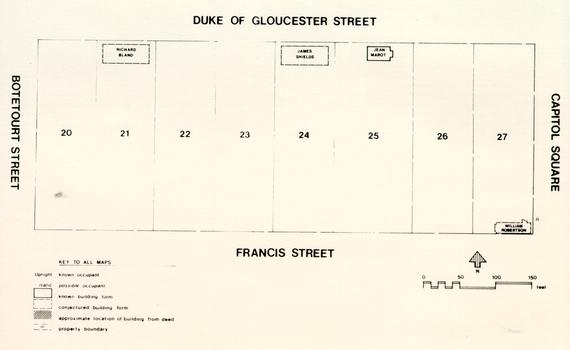 Figure 1. Block 9 in 1708. 3
house thereon built."3 This was probably the house built by Shields soon after he was conveyed the property. It is assumed, based on later records, that Shields shortly conveyed lots 22 and 23 to Byrd as well.
Figure 1. Block 9 in 1708. 3
house thereon built."3 This was probably the house built by Shields soon after he was conveyed the property. It is assumed, based on later records, that Shields shortly conveyed lots 22 and 23 to Byrd as well.
On January 24, 1707/8, Shields conveyed lot 25 to Jean Marot, a Hugeonot tavern keeper, for £50.4 The price of the lot, less than half that paid by Byrd for lot 24, suggests that few if any buildings were on the lot at the time of the sale. Soon after, however, Marot probably erected a 20 by 32 foot building fronting on the main street. Only four months later, on May 24, 1708, Marot purchased a 40 foot square portion of lot 26 from William Robertson,5 presumably to expand his new tavern by building a 20 by 39 foot addition to the east.
Perhaps around this time, and certainly by 1716, Richard Bland had purchased lots 20 and 21, west of Byrd's three lots. Bland, clerk of Prince George County in 1708, had become a vestryman of Bruton Parish Church by 1710. Between 1709 and 1712 he lived at Jordan's Point in Charles City County, but also had a townhouse in Williamsburg, where he managed a store with William Byrd. This store might have been located on either lot 20 or 21, but equally well could have been across the street on lot 53 or 54, conveyed to Bland in 1708 by the Trustess of the City. Similarly his house, frequently referred to in Byrd's diary,6 may have been either on the northern or on the southern side of the street.
Elaboration and Subdivision (1710-1717)
Little is known about whatever embellishments may have occurred between 1710 and 1715. On only one property, Marot's Ordinary, does there seem to be a major datable renovation. This consisted of the addition of an 11 foot wide "shed" on the south facade of the building and a 16 by 23 foot kitchen appendage on the east (see Figure 2). These changes, clearly shown by non-bonded brick joints on the foundation, are probably represented in the documentary record in a suit brought against Marot by carpenter Richard King for £46.7.6, an amount he claimed was due for carpentry work on Marot's house.7
By 1716 Richard Bland had decided to sell lots 20 and 21, and they were purchased on May 23 by Colonel Nathaniel Harrison of Wakefield, Surry County.8 Harrison apparently purchased Bland's property for use as a townhouse, and it appears that at least by this time some sort of dwelling had been erected on lot 21.
Harrison's neighbor to the east is not definitely known. A major gap in the records exists between Byrd's purchase of lot 24 (and presumably lots 22 and 23) in 1707 and the next mention of these lots in 1749. Archaeological investigations have revealed
4
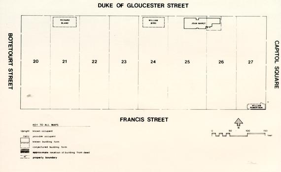 Figure 2. Block 9 in 1715.
5
only negative evidence, that is, that no early 18th century structures beyond Byrd's possible dwelling house on lot 24 have yet appeared. It can only be said that Byrd probably owned these lots for an undetermined length of time, but whether and for how long he actually lived there is a mystery.
Figure 2. Block 9 in 1715.
5
only negative evidence, that is, that no early 18th century structures beyond Byrd's possible dwelling house on lot 24 have yet appeared. It can only be said that Byrd probably owned these lots for an undetermined length of time, but whether and for how long he actually lived there is a mystery.
Meanwhile William Robertson had by 1718 completed the first major subdivision of the original Block 9 lots. On November 10, 1718 Robertson sold to Dr. John Brown for £50:
. . .all that parcel of Ground lying & being in the City of Williamsburgh, (being part of the sd Robertsons Lotts whereon he now lives,) Beginning at that Corner of Lott 27 which joins on Duke of Gloucester Street & the Capitol Square & running thence South ¼ of a degree East Twelve poles thence West ¼ South Two poles Six links to a Stake Standing about four foot from the Corner of the sd Robertsons Milk house Thence North Twelve Degrees five minutes West Eight Poles to the Third post of the Garden pales a little above the Upper Corner of the Barbers Shop Thence West a ¼ South three poles Twenty Two links thence North a ¼ West along Sullivants Pales to his Corner post on the Main Street four poles & thence along the Street to the place where it began... With all houses... (York County Records, Deeds & Bonds, Book III, p. 267)
Dr. John Brown came to Virginia from Coldstream in north England around 1716. Upon his purchase of the northern part of lots 26 and 27, he probably built a dwelling house. This house almost certainly fronted on Duke of Gloucester Street, perhaps lying under the restored Palmer House. Whether it was similar in form to the Palmer House, a large square brick dwelling built after 1759, is not clear.
The Robertson-Brown conveyance gives the description of the lot boundaries, which reveals the locations of Robertson's milk house, barbers shop, and palings. Archaeological evidence of the two outbuildings is lacking, possibly indicating that they were post- or pier-supported frame structures, and thus missed by the crosstrenching. Nonetheless the wording of the deed enables them to be almost precisely placed on the property.
The Timothy and Anne Sullivant Period (1717-1730)
After Jean Marot's death in 1717, his wife Anne married Timothy Sullivant. Possibly a former stone-cutter, his prior history is very unclear. This couple are the Sullivants whose palings are described as one boundary in the Robertson-Brown conveyance above. Soon after their marriage Timothy Sullivant 6 apparently turned over the tavern keeping to his wife, as she appears in subsequent records applying for licenses in her own name. On at least one occasion, in 1724, her former neighbor William Robertson appeared as security for her license.
Through most of the late 1710s and early 1720s, the Sullivants' neighbors remained the same: Dr. John Brown on the northern part of lots 26 and 27, William Robertson on the southern part of the same two lots, Nathaniel Harrison on lots 20 and 21, and an unknown occupant (possibly William Byrd) on lot 24 (see Figure 3). By 1923, however, William Robertson had sold his remaining property to John Grymes, a Burgess from Brandon in Middlesex County.9 It appears that Grymes probably used the property for a townhouse, very likely utilizing the structure built as Robertson's dwelling.
Elsewhere on the block, Nathaniel Harrison's death in 1726 resulted in the inheritance of the property by his son Benjamin, who presumably moved into the dwelling house of his father. Dr. John Brown died in the same year, but his property was probably retained by his wife Mildred.
The Anne Sullivant Period (1730-1738)
Timothy Sullivant died around 1730, leaving a meager personal estate. His wife Anne retained the ordinary, which she was to keep another eight years. In 1730, however, the remarriage of her neighbor Mildred Brown resulted in another lot split. Brown's widow married Henry Willis of Spotsylvania County and put her Williamsburg property up for sale. On June 15, 1730, a 3968 square foot area on lot 26 was sold to watchmaker John Stott.10 On July 1, 1732, the remainder of the property was sold to Scottish jeweler Alexander Kerr.11
Stott probably soon erected a house on his property, or perhaps added to an existing one, most likely creating the 16 by 38 foot building later called the Walthoe House (see Figure 4). There is some indication in the deed that some small building was already located on the property, though the purchase price of £35 would seem to suggest that the building, if any, was not very substantial. In contrast the same lot, with dwelling, was sold nineteen years later for £116.
Kerr probably occupied the same building as the dwelling house of Brown. By 1736 he was expanding, albeit illegally, by making "several Encroachments upon the Capitol Square, particularly in setting a Brick-Kiln upon the Capitol Bounds."12 This may have been a temporary kiln for enlarging his house.
Few changes appear to have been made in this period elsewhere on the block.
7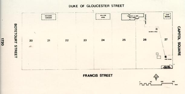 Figure 3. Block 9 in 1720.
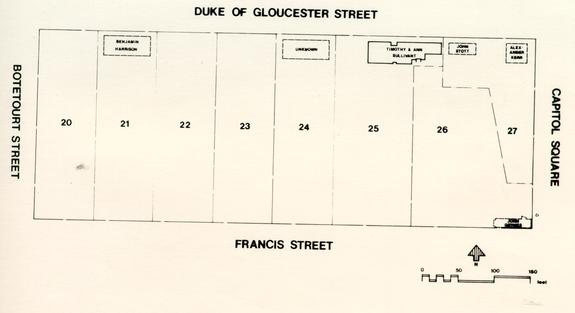 Figure 4. Block 9 in 1735.
John Taylor's Ordinary (1738-1745)
On August 25, 1738, the following notice appeared in the Virginia Gazette:
Mrs. Sullivane [Sullivant], of Williamsburg, having left off Publick Business, and retir'd to the Country, the Subscriber hath taken the same House, and now carries on Publick Business, where Gentlemen may depend on kind Treatment, and good Accomodations for themselves, and extraordinary Pasturage and Stabling for their Horses, from their very humble Servant,
JOHN TAYLOR13
Little else is known about this John Taylor, who was possibly to occupy Anne Sullivant's former ordinary for up to seven years.
Other changes in the block were taking place as well (see Figure 5). In 1738 Benjamin Harrison sold lots 20 and 21 (probably mistakenly recorded as 21 and 22) to tavern keeper Henry Wetherburn in return for £150. Wetherburn first appeared in Williamsburg around 1731, when he was granted a license for an ordinary elsewhere in town. By 1736 he had married Mary Bowcock, the widow of tavern keeper Henry Bowcock, and established a tavern, either on lot 53 or on the possibly-rented lots 20 and 21. Certainly after 1738, when he purchased the latter lots, he was well on his way. By 1742 he was operating the Raleigh Tavern on lot 54, on the north side of Duke of Gloucester Street. He also owned lot 57, across the street from John Stott's land. Although owning the land for up to eight years, it was apparently not until 1746 that he operated a tavern on lots 20 and 21.
Meanwhile 1738 also saw the death of Alexander Kerr. The advertisement for his estate sale reveals that he had, at the time of his death, "a well furnished Brick House, in good Repair, together with a convenient Store, Coach-House, Stables, and other Office-Houses, and a large Garden. . ."14 He was apparently not married, and the disposition of his property for the next ten years is not clearly known.
The Grymes property is even more puzzling. Because at least part of the property lay in James City County, and this part included the dwelling house, it is possible that land transactions were recorded in the James City County court rather than the court for York County. Unfortunately the James City County court records were destroyed during the Civil War, and therefore little is known about these properties.
In 1738 an advertisement in the Virginia Gazette stated:
10
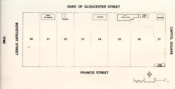 Figure 5. Block 9 in 1740.
11
Figure 5. Block 9 in 1740.
11
George Charlton, Taylor, lately arriv'd from London, now lives in Williamsburg, at the next House to Col. Grymes's (late Mr. Clayton's) by whom Gentlemen may have Cloaths made, after the newest and most fashionable Manner .... 15
This seems to indicate that Grymes was still on lots 26 and 27 in 1738, and that a George Charlton (and before him a Mr. Clayton) lived next door. This could possibly have been the house later occupied by William and Thomas Nelson, later reconstructed as the Nelson-Galt House.
It does seem clear that between 1739 and 1741 William Byrd II was a frequent visitor to Colonel Grymes' house, as his diary contains at least six references to his visits. As Mrs. Byrd and daughters often lodged with Grymes, it would appear that by this time at least Byrd no longer owned his father's townhouse on lot 24.
The actual occupant of lot 24, and of lots 22 and 23, remains a mystery during this period. one must assume that Byrd's former townhouse was probably still standing, as it is mentioned in a 1749 deed. By around 1740 there was probably also a building on lot 22, based on archaeological findings.16 This building was identified, from only portions of its west and south foundation walls, as a structure at least 15'3" wide' and 20'10" deep, constructed in the second quarter of the 18th century. It was called a warehouse in 1749, but indications are that in 1745 it was actually used as a store.
The Shields Tavern (1745-1750)
By May 1745 John Taylor was no longer on lots 25 and 26, and the former Sullivant's Ordinary property had been taken over by Jean Marot's daughter Anne and her husband James Shields, son of the Shields that sold the property to Marot in the first place (see Figure 6). James Shields apparently operated the tavern until his death around December 1750.
On July 4, 1745 a small clue to the activities on the lots west of the Shields Tavern appeared in an advertisement in the Virginia Gazette, which stated:
Just imported in the Ship Restoration, Capt. John Wilcox, from London, by the Subscriber, next Door to Mr. Crosbie's, Merchant, in Williamsburg, A Choice Parcel of Hairs, and other Materials, for making Wigs, prepar'd by the best Hands in London ....
Alexander Finnie.17
The "Mr. Crosbie" mentioned is undoubtedly James Crosby, a Scottish merchant who was apparently the owner of lots 22, 23 and 24 in 1749. If, as a later deed suggests, Crosby had a store on
12
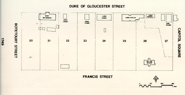 Figure 6. Block 9 in 1749.
13
lot 23, then Finnie's store would most logically be located on lot 22, probably in the 21 foot deep building found during archaeological investigations. The Carter Burwell Papers reveal that a "Mr Crosby Mert" bought a number of bricks and lumber from James Bray in 1740,18 further suggesting that Crosby may have been in the area (and possibly on these lots) by 1740.
Figure 6. Block 9 in 1749.
13
lot 23, then Finnie's store would most logically be located on lot 22, probably in the 21 foot deep building found during archaeological investigations. The Carter Burwell Papers reveal that a "Mr Crosby Mert" bought a number of bricks and lumber from James Bray in 1740,18 further suggesting that Crosby may have been in the area (and possibly on these lots) by 1740.
Regardless, by 1749 Crosby certainly owned the lots, as he transferred them to Scottish merchants Andrew and Archibald Buchanan & Company:
[February 26, 1749/50]
[Crosby, James, merchant of Glasgow
to
Buchanan, Alexander Archibald & Company
Consideration: "a certain Sum of Money"]THIS INDENTURE made the Twenty Sixth Day of February one thousand and Seven hundred and forty Nine fifty Years BETWEEN James Crosby Merchant in Glasgow in North Britain of the one part and Andrew Archd Buchanan's & Company Merchants of Glasgow of the other part WITNESSETH that the said James Crosby for and in consideration of a certain Sum of Money, the receipt whereof is hereby Acknowledged doth give grant enfeoff and confirm unto the said Andrew Archd Buchanan's & Company... forever Three Lots of Land containing half an Acre in each Lot (upon one of which Lots there is built a Dwelling House & Kitchen upon the Middle Lott is a Storehouse and upon the other Lott there is a Ware house & Stable... all lying Contiguous in the City of Williamsburgh on the South side of the Main Street opposite to the Rawley (Raleigh] Tavern which said Lots are marked in the Plan of the said City by the Nos [not given] which formerly belonged to the late Colonell William Bird of Charles City County) TO HAVE AND TO HOLD... forever.... James Crosby (L.S.)
Signed Sealed & delivered
(York County Records, Deeds, Book V, pp. 393-394)
in Presence of
William Seller
Hugh Brown
Robt Walkerston
[Recorded York County Court
June 18, 1750]
It is important to note that the structures on the property are first mentioned here: a dwelling house and kitchen on one lot (probably lot 24), a storehouse on the middle lot (lot 23), and a warehouse and stable on the other lot (lot 22). The dwelling 14 house is most likely the structure built by Byrd before 1710, while the warehouse is probably the archaeologically-discovered building on lot 22 possibly used by Alexander Finnie in 1745. The stable on lot 22 and the storehouse on lot 23 were not located archaeologically, probably either because they were later obliterated by subsequent construction or because they were pier or post-supported and thus missed by the crosstrenching.
West of these three lots, Henry Wetherburn had a thriving tavern. It location is well described in a 1746 notice for a sale across the street:
Harmer and King have been traced to lot 52, directly opposite lot 21 on the north side of Duke of Gloucester Street.[January 23, 1746]
THE dwelling house, Out houses, Store Houses, &c in the main Street opposite to Mr. Wetherburn's in Williamsburg, (the most convenient Spot in this City for Trade, and a well accustomed Store,) now the property of the Subscribers, will be exposed to publick Sale, to the higher Bidder, at the said House, on Tuesday, the 4th of March next ....
Harmer & Kingl9
Wetherburn's Tavern at first probably occupied a 45.1 by 26.2 foot area on the eastern side of the now-reconstructed building. This area is referred to in the archaeological report as the "Phase I Building."20 At an uncertain later date, a large addition was placed on the western side of the structure, nearly doubling the size of the tavern.
Whether the larger building or the smaller by 1750 Wetherburn's Tavern had a fairly extensive group of outbuildings, including a kitchen, dairy, smokehouse, and well (see Figure 7).21 The first well on the property was apparently abandoned around 1750, as included in the abandonment fill was a molded glass bottle bearing the inscription "ROB TURLINGTONs BALSAM OF (LIFE) BY THE KINGS PATENT MARCH 25, 1750." Pieces of what was probably the same bottle were also found in a burned area of ash and clay east of the well, indicating a fairly major contemporary fire. Whether this fire in fact burned down the tavern cannot be determined, but in any case it at least approached the tavern's foundations. After the well's abandonment another one was dug to the southeast, following an aborted attempt a little farther west.
The area east of Shields Tavern was also undergoing significant changes. Upon his death, John Stott's house and land was in 1749 sold to Lewis Burwell for £116.22 Burwell did not own the property for long, however, as on January 21, 1750/1, he sold it to Nathaniel Walthoe, a "Gent" of the City of Williamsburg, for £120.23 Walthoe, a close friend of William Byrd II, also
15
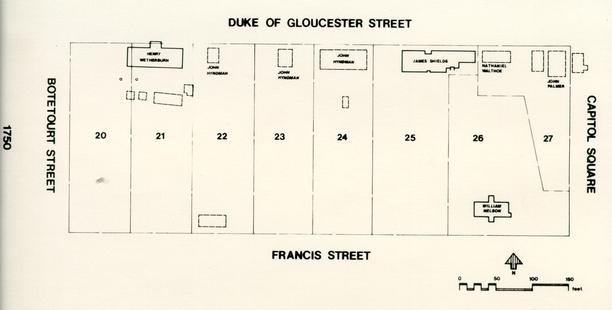 Figure 7. Block 9 in 1750.
16
purchased a storehouse and land across the street on lot 58, and in the next year purchased property on Nicholson Street behind the Raleigh Tavern.
Figure 7. Block 9 in 1750.
16
purchased a storehouse and land across the street on lot 58, and in the next year purchased property on Nicholson Street behind the Raleigh Tavern.
East of Walthoe's house was the former Kerr property, owned in 1749 by lawyer John Palmer. In addition to his house, Palmer apparently had a store, as in August 1750 "the store of Mr. John Palmer" is located "opposite to a storehouse of Nathaniel Walthoe [on lot 58]."24 This was probably the store in which a disastrous fire was to occur in 1754.
South of Palmer's house was the former Grymes property, which had apparently passed out of Grymes' hands before 1748 (as there is no mention of it in his will). By 1749 this land had come into the possession of William Nelson and his son Thomas Jr. William Nelson, a merchant in Yorktown, was quite powerful, eventually becoming President of the Council. His son Thomas was later to be the renowned General Thomas Nelson during the Revolutionary War. It is, however, unclear whether the Nelsons ever in fact lived on their property in Williamsburg, or instead rented it out to tenants.
The Final Years of the Shields Tavern (1750-1754)
James Shields died around December 1750, leaving in addition to his Williamsburg property a plantation at Skimino and another one on Mill Swamp. His inventory, recorded on January 21, 1750/1, clearly identifies the rooms at the tavern and their uses: the parlour, hall, upstairs, lower room, shed, barr, garden room, chamber & kitchen, closet, and cellar.25 It is probably significant that no outbuildings are mentioned, although the presence of hoes, a spade, a "waggon," a cart, two (riding) chairs, a wheel barrow, and eight horses suggests the presence of at least a stable. It seems clear that most if not all of the domestic chores were taking place within the tavern building itself; the first mention of an outbuilding (other than the milk house in Marot's inventory) is not until some twenty years later.
Shortly after James Shields' death, Henry Wetherburn's second wife also died. Ten days after her death, on July 1, 1751, Wetherburn married Shields' widow Anne Marot Ingles Shields. Less than a month later Wetherburn advertised Shields Tavern for rent:
August 8, 1751
TO be let, and Entered on immediately THE Tavern lately kept by Mr. James Shields in Williamsburg, with all convenient Outhouses. Enquire of
Henry Wetherburn. 26
It was leased to tea, coffee and wine merchant Daniel Fisher, a recent immigrant from England. By this time the tavern had 17 apparently become known as the "English Coffee House." Fisher seems to have failed as a tavern keeper, as in 1752 he abandoned the venture:
Several Difficulties and Impediments in the Business I so lately undertook, subjecting me to the Necessity of giving it over; I thought it incumbent on me to give this Notice thereof.
I have divers Rooms or Apartments to let, also a large Stable with Stalls for about Twenty Horses.
Daniel Fisher.27
Aside from boarding individuals, he had a store in the building, where he sold tea, coffee, and wine.
The Wetherburns leased out the former Shields Tavern, but they were by no means finished with tavern keeping. Wetherburn's Tavern on lots 20 and 21 continued in operation despite some sort of fire around 1750, a highly-praised establishment (even by Daniel Fisher, despite some long-lasting antagonism toward its owner). There is some indication that the Wetherburns may have temporarily abandoned their tavern in 1752, renting it to a John Doncastle, who attempted to sell his former establishment:
To be Rented, and entered on the first of MARCH next, THE Ordinary, at King-William Court-House, where the Subscriber now lives .... to be sold on the Premisses .... and as the Subscriber has taken the House of Mr. Wetherburn in Williamsburg, to enter the first of March next, all Gentlemen, &c that please to favour him with their Custom, may depend on the best Accomodations, from Their very humble Servant, John Doncastle 28However, it seems most likely that the establishment Doncastle rented was in fact the John Crump House on lot 57, which Wetherburn also owned.29 Alternatively, it may also have been one part of the former Shields Tavern, which Wetherburn, through his wife, also owned. In any case, Wetherburn was back to tavern keeping on lots 20 and 21 by 1756.
Lots 22, 23, and 24 had been purchased by Andrew and Archibald Buchanan & Company in 1750, but the Scottish merchant firm apparently did not immediately establish themselves on the premises. Instead their attorney, merchant John Hyndman, seems to have taken over the operation. In November 1752 Hyndman, acting as attorney for the Scottish owners, sold lot 24 to Dr. Kenneth McKenzie.30 McKenzie owned lots 333, 334, 335 and 336 on Palace Street until December 1751, when he leased or sold them for the use of the Governor while the Palace was being reconditioned. He apparently lived on lot 24 until his death in 1755, probably maintaining a medical shop in his dwelling.
The Fire of 1754
In April 1754 Daniel Fisher was witness to the destruction of most of the buildings on the east side of the block (see Figure 8). As he records in his diary:
21 Walthoe's house and Palmer's house were destroyed, as was the store in which the fire started and a jewelry shop. The Maryland Gazette offered an account of the fire:. . .on Saturday the 24th of April, 1754, about 8 in the Evening, I being just got to bed my Daughter alarmed me with the cry of Fire at a neighbor's house, one Mr. Palmer, an Atty; there was our good friend Mr. Walthoe's house only between which and us; the apartment where the fire began was a back room or counting house joining to a store next Mr. Walthoe's, which was let to a merchant (Mr. Asborn [Osborn]) who was gone to England to fetch over his Family, and by the neglect of his Brother-in-Law who kept the Store in his absence, in leaving a fire too carelessly in the said room, while he staid longer than he intended at a Public House, the floor first catched and then the window curtains. With any tolerable management, the fire might easily been extinguished, but nothing was sure for a great while but uproar, confusion and disorder. Some person, whether with a good or bad intention, was never known, gave the word that there was a large quantity of Gun Powder in the store, which struck a general terror for a considerable time, and the rope to my well, the nearest and only water within a good way, was broke or cut after drawing the first or second bucket. Mr. Palmer's well indeed was close by the room where the fire kindled, but the Cry of the Gun Powder hindered that from being used till it grew too hot to stand at all in that place. The running off with the foods was the chief thing minded, tho' the great bugbear the Gun Powder was neglected, till at the last a Negro of Mr. Walthoe it is said, got up (it being kept just over the store or shop) and tumbled one of the barrels into the street, but the flames having then burst into that room also, the man was obliged to jump down himself to save his life. This was a little less than an hour after the fire was discovered. When the Powder Catched, the whole roof, (covered with shingles, indeed we have no other) was in a blaze. Between the East end of Mr. Walthoe's house and this in flames, was a void space of about Thirty foot, and the wind directly at west, a strong Gale, so that but from the effects of the Gun Powder, there was no great danger, or had his house been covered with Tile slate or any other material not combustible, it had nevertheless remained safe. But the explosion of the Gun Powder, (the roof then all in a blaze) scattered the firebrands upon Mr. Walthoe's house, already heated or d[r]yed like tinder by the adjacent flames, set his house also instantly in a blaze. Had his house been 19
Figure 8. Block 9 in 1754. 20 covered with wet bags or blankets, that would have preserved it, but for more than an hour not a ladder (or other useful implement) could hardly be met with. My Pails, Buckets, Tubs, Axes, Spades etc. etc. were indeed delivered immediately, but except the well bucket which was secured at the bottom of the well, I never received one thing any more. The Capitol tho' more than 200 feet distant was by its eastern situation in great danger of being burnt a second time, the shingles catching several times. But that being better attended and supplyed with water etc, etc, it was preserved, tho' at a considerable expense, the assistants there being well paid: whereas, save Mr. Walthoe gave out of his own Pocket to Persons who pretended to have aided at Mr. Palmer's and his own house, the recompense of the helpers in general, consisted in what they ran away with, of the substance of the sufferers. Between the West end of Mr. Walthoe's and the east End of my house, was a void space of no more than about four foot. Yet as the explosion was over, without affecting me, and the wind continued to blow still strong at West, I would not suffer any of my goods to be removed out of my house, which was then beset by great numbers of lazy negroes, calmly viewing the Bon Fire. I spoke to a knot of these, exhorting them very civilly to assist in drawing or fetching water, etc., but received a surly reply with an oath of who will pay us? But... Mr. John Holt... countenanced and supported by many others no better affected to me than himself, at this instant authorized and commanded these Black Spectators to level or pull down my house to the ground, under the pretence of its being for the Public good by preventing the flames spreading farther into the Town.
... This Righteous order was no sooner issued, than these Lazy fellows became the most active industrious people in the world. For in a moment my doors which I had locked or barred, were all broke open, and every part of my house filled with Negroes... (who] ran away with whatever of my substance they thought fit.
... It is not possible for me to compute the damages I sustained in this unparalleled depredation on my goods... at this time a Gentleman (Mr. Benjm. Grymes) arrived and seeing the mob so busy in pulling down the house, desired to know the meaning of the shocking violence which had been committed; he put an immediate stop to their outrage... and stepping up himself upon the East end of my house next the flames with the aid of three or four such hands, stopped entirely the spreading of the Fire without any further devastation.31
Archaeological cross-trenching on the property revealed what might be the foundation of the jewelry shop, encroaching upon Capitol Square east of the restored Palmer House, but no traces of a store building were found to the west. This is not surprising since Fisher's description, 30 feet east of the Walthoe house, would have placed it under the west wall of the Palmer House, and thus not archaeologically tested.WILLIAMSBURG, April 25.
Last Saturday Night, about Eight o'Clock a terrible Fire broke out in the Store of Mr. Charles Osborne, of this City, which burnt for two Hours with great Vehemance, and entirely consumed the same, together with two Dwelling Houses and a Jeweller's Shop, adjoining; but was, by the Vigilance and Activity of several Gentlemen present, prevented from doing any further Mischief, the whole Loss is computed at upwards of Five Thousand Pounds.32
The Post-Fisher Period (1754-1770)
Fisher's experiences were little better after the fire. The following winter his house was broken into five times, and each time the thieves were either not caught or allowed to go free (once, according to Fisher, with the express permission of his neighbor John Palmer). By 1755 Fisher had probably departed for Philadelphia, and had certainly abandoned the Wetherburns' property on lots 25 and 26. What follows is a fifteen year gap in the documentary record concerning this property.
Fortunately the activities on the rest of Block 9 are known somewhat better. Wetherburn kept his tavern on lots 20 and 21 until his death in 1760, probably elaborating his operation with the construction of a large kitchen/laundry and a more spacious smokehouse (see Figure 9). In 1759 he sold a 40 by 56 foot piece of land on the northwestern corner of lot 20 to merchant James Tarpley.33 Tarpley probably soon erected a building on the lot, mentioned in a 1763 deed as a "new store house."34
Soon after his acquisition of the lot Tarpley dissolved his former partnership with Alexander Knox. By 1761 he was in partnership with printer William Hunter, and after Hunter's death with a John Thompson. Tarpley and Thompson continued as partners until Tarpley's death in 1764, and Thompson seems to have remained on the property for some time afterward, though advertising it for sale in March 1765, December 1766, and February 1767.35 In 1767 the storehouse was sold to Jonathan Pride, a merchant from Yorktown, for £450.
22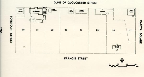 Figure 9. Block 9 in 1760.
Meanwhile Wetherburn's lots were undergoing changes as well. When Henry Wetherburn died in 1760 he left his wife Anne "the Dwelling House Outhouses and two Lotts of Land No 21 & 22 [actually 20 and 21] in the City of Williamsburg excepting the Tenement in Possession of James Martin Barber .... "36 This tenement was probably the building referred to by Ivor Noël Hume as Building East A, a partial foundation found during 1965-66 archaeological excavations. If this is indeed the same building, then the above reference is the first documentary record of its presence. However, from a purely archaeological standpoint, the exact date of construction is unknown.
Anne Wetherburn continued to live on the property until her death in 1767, letting out rooms in the former tavern to boarders and keeping the separate tenement where Martin the barber apparently lived through 1765. By June 1767 tavern keeper James Southall had taken over the property, which he reestablished as a tavern. His account books for 1768 show his rates:
| 1768 | The Estate of Samuel Middleton Decd | |
|---|---|---|
| May 2 | To Today 1/3 Dinr & Club 4/ | £ -.5.3 |
| 3 | To Julip 7 ½ Punch 1/6 Club | |
| do 21 ½ | 1.4.3 | |
| To dinr & Club 4/3 Cash lent 20/ | 1.4.3 | |
| 4 | To Julip 4/10 ½ Punch 1/6 | |
| Dinr & Club 4/6 | -.7.10 ½ | |
| 5 | To Breakfast 1/3 Julip 7 ½ | 1.10 ½ |
| £ 2.3.637 |
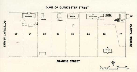
The fate of Lots 22 and 23 is not clearly known, although archaeological excavations have suggested no major building phases in the fifteen year period between 1755 and 1770. On Lot 24 Dr. McKenzie's widow Joanna lived until her death in 1767, possibly operating a milliner's shop from her home.38 In 1760 she mortgaged her property to Dr. James Carter, incidentally indicating that lot 23 (and possibly lot 22 as well) were at that time occupied by Carter's brother, merchant John Carter.39
It was not until Mrs. McKenzie's death in 1767, however, that lot 24 was actually sold. The purchaser was printer Alexander Purdie. Born in Scotland, he had been employed by printer Joseph Royle at the Post Office until 1764, and continued printing the Virginia Gazette at the same location after Royle's death. He was later to establish his printing office (and the Post Office) elsewhere on Block 9, at the former site of Tarpley's store on lot 20.
By 1769 John Carter definitely occupied lot 23 and intended to soon vacate the property. A notice in the Virginia Gazette announcing his intentions stated: 24
Particularly interesting is the reference to the "Shop near Mr. Charlton's" offered for rent. This shop must have been located on the western side of lot 23, since "Mr. Charlton's" most probably refers to Edward Charlton, occupant of lot 22 by 1772 (and, if this notice is to be believed, by 1769). Carter's property, including the dwelling house and probably the shop as well, was sold in 1772.February 23, 1769
The subscriber, intending for England immediately after the June Court, is under a necessity of desiring all those who are indebted to him to pay off their respective balances by that time, or he must put their accounts into an attorney's hands; and, as he has a large assortment of goods in his store, that he may get rid of them if possible by the last of June, he is determined to sell them very cheap, for ready money only.
JOHN CARTERN.B. The Shop near Mr. Charlton's is to be rented.
(Virginia Gazette, Purdie & Dixon, eds., February 23, 1769)
The fire of 1754 had literally devastated the eastern side of Block 9, and several years seem to have passed before any new construction. Nathaniel Walthoe probably moved elsewhere after the fire, finally selling his portion of lot 26 to John Palmer in 1759. The low selling price, £60, suggests that a dwelling house had probably not been rebuilt, though the language of the deed indicates that one or more outbuildings may have been still standing.40
Between 1759 and 1765, Palmer or his heirs probably rebuilt on the eastern side of lots 26 and 27. This new dwelling house was most likely the large brick building since reconstructed as the Palmer House. Whether it mirrored Palmer's burnt dwelling is unknown, though it appears that Palmer's former house was substantially smaller, since based on the lack of archaeological evidence the house and Osborne's store would both have to be accommodated in the space now under the Palmer House. Palmer's choice of a brick building is probably no accident, given his justified wariness about another fire. After Palmer's death in 1760, his heirs leased the property to a series of tenants, including cabinetmaker Benjamin Bucktrout in the late 1760s.
The southern part of lots 26 and 27 remained the property of the Nelson family. Virtually no data has come to light concerning their activities on the property between 1755 and 1770.
Before and During the Revolution (1770-1780)
The former Shields Tavern lot had apparently remained the property of Shields' heirs after his death in 1750. The Shields appear to have leased the house to tenants until around 1770, when James Shields III (son of James and Anne Shields) sold the property to merchant William Goodson (see Figure 10). Goodson may have occupied part of the house, but his clear intention was to lease part of it out to tenants as well. On August 27, 1770, Goodson leased the western half of the house, comprising the portion west of the double chimney, to blacksmith and farrier John Draper:
THIS INDENTURE made the Twenty seventh day of August... [1770] BETWEEN William Goodson of the City of Williamsburg Merchant of the one part and John Draper of the same place Farrier and Blacksmith of the other part WITNESSETH that the said William Goodson for and in Consideration of the Yearly Rent Covenants and Conditions hereafter in and by these presents expressed on the part and behalf of the said John Draper... HATH Demised Granted and to Farm Letten... unto the said John Draper... all that part of a Messuage or Tenement which he at present occupies in the west End of the House and Ground lately purchased of Mr James Shields of the Parish of Bruton in the County of York Planter situate on the Main Street in the City of Williamsburg between the Lott late belonging to the Estate of Mr John Palmer deceased on the East Consisting of two Rooms a Kitchen and a Shed on the Ground Floor and two Rooms above Stairs together with a Blacksmiths Shop behind the same. Also one half of the Garden and such part of the Stable as shall be hereafter immediately laid of[f] for his Use and one of the Cellars under the Dwelling House ... TO HAVE AND TO HOLD... unto the said John Draper ... from the Twenty Fifth day of October now next ensuing and fully to be Compleat and Ended YIELDING AND PAYING therefor Yearly and every Year during the said Term unto the said William Goodson the Rent of Twenty two Pounds Current Money of Virginia... AND the said William Goodson for himself his Executors... doth Covenant Promise... and Agree... with or without Workmen twice or Oftener in every Year during the said Term at Convenient Times in the Day to enter Come into and upon the premises and see the State and Conditions of the same and of all such Defects decays and wants of repairations as shall then be found needfull and necessary... and the same to repair and amend within some short time Afterwards AND further that he the said William Goodson doth reserve to himself the Liberty of pulling down the old Balcony at the front of the said premises whenever he pleases to do so .... (York County Records, Deeds, Book VIII, p. 76)26
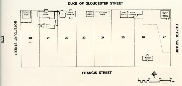 Figure 10. Block 9 in 1770.
It is interesting to note the mention of a garden, a stable, and a blacksmith's shop on the property. Draper may have already occupied the property before this indenture, since there would seem to be little other reason for an already-present blacksmith's shop. Archaeological excavations in 1958 on the site of the reconstructed John Coke Office, then part of Draper's holding, revealed a large chimney or forge base surrounded by colonial period postholes, possibly the remains of a post-supported smithy. Another possible forge was located in 1985 behind the present Marot's Ordinary, several feet west of a previously-undiscovered well partially filled with slag and other industrial waste. The nature of the fill indicates almost certainly that it was filled by Draper, using the by-products of his blacksmithing operation.
In 1772 Goodson leased the eastern half of the house, not including the small addition on the east side of the building, to physician John de Sequeyra:
THIS INDENTURE made the eighteenth day of June... [1772] BETWEEN William Goodson of the City of Williamsbq Merchant of the one part and John de Sequeyra of the same place Doctor of Physic of the other Part. WITNESSETH that for and in consideration of the sum of five shillings by the said John to the said William in hand paid on or before the ensealing... of these presents... And for and in consideration of the Rent herein after reserved he the said William Goodson hath granted demised and to farm letten... unto the said John de Sequeyra his Heirs Executors... all that part of the Lott lately purchased by the said William Goodson of James Sheilds now in the possession and occupation of the said John de Sequeyra lying and being in the City of Williamsburg on the South Side of Duke of Gloucester Street with all those three Rooms thereon which are to the East end of the large dwelling House on the said Lotts and adjoin the small Shop now occupied by Thomas Craig with the Cellar under the same except one Room thereof not in the use of the said John de Sequeyra and the Rooms above with the Passages and every part of the House aforesaid which lies to the Eastward of the Rooms aforesaid or any of them or above them with the small yard adjoining thereto and all Houses Kitchens and Buildings except the small Shop aforesaid which are Situate on any part of the Lott aforesaid which are now in the possession of the said John de Sequeyra together with one Half of the Garden on the said Lot and the free Use of the Well thereon. TO HAVE AND TO HOLD... unto the said John de Sequera [sic] ... for and during the term of Seven Years from the day next of the date of these presents. YIELDING AND PAYING therefore yearly on the nineteenth day of June in every Year the full and just Sum of thirty pounds Current Money of Virginia And 28 the said John de Sequeyra doth hereby covenant and agree to and with the said William Goodson that he will during all the term aforesaid keep the Houses on that part of the Lot aforesaid in good and Tenantable Repair Fire Storms and Natural decays only excepted .... (York County Records, Deeds, Book VII, pp. 236-238)The small addition east of the building was leased by Thomas Craig, a tailor who apparently at that time used the addition as a shop (see Figure 11). This part of the building was formerly used as a kitchen, and thus it appears that de Sequeyra probably had an exterior kitchen instead. This is most likely the partial outbuilding foundation found during cross-trenching behind Marot's Ordinary in the 1950s, a building defined only by a large chimney base and portions of its west and south walls. The two outbuildings currently reconstructed on this part of the property, the Stillhouse and Dairy, were probably in fact early 19th-century structures, built long after de Sequeyra's departure.
Draper and de Sequeyra probably shared the tenement for a considerable length of time, until Draper moved to his own property on Block 8 in 1780. De Sequeyra appears to have remained until the 1790s, despite the provision in his original lease that called for him to be there only seven years. Thomas Craig does not appear in any other records concerning Goodson's tenement, and therefore his date of departure is not clear.
Before and during the Revolution was a time of change on the rest of Block 9 as well. Jonathan Pride continued to own lot 20 until 1774, but by 1773 it was occupied by a tenant, merchant James Hubard. Pride had the property up for sale even while Hubard was still living there:
It was not immediately sold, and Hubard continued to occupy the property until his death in 1774. The property was then occupied by jeweler and clockmaker Robert Bruce,41 who very likely had his dwelling in the 20.7 by 22.3 foot building Noël Hume refers to as Building West A.42 Archaeological excavations revealed no clear construction date for the building, but it is assumed that it was standing by the 1770s. 29[October 20 [14], 1773]
THE commodious and well situated HOUSE and STORE on the main Street in Williamsburg, formerly the Property of Mess. Tarpley and Thompson, and at present occupied by Mr. James Hubard. For Terms inquire of the Printer, or of the Subscriber in York Town.
(Virginia Gazette, Purdie & Dixon, eds., October 20 [14], 1773)
RICHARD BROWN
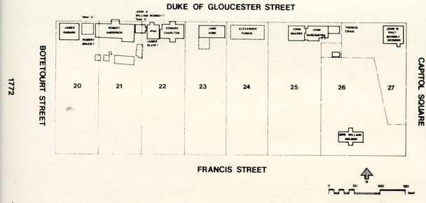 Figure 11. Block 9 in 1772.
Bruce retained the shop and dwelling for only a short time, as by December 1, 1774, printer Alexander Purdie was offering notice that he occupied the premises:
Apparently Purdie used both the shop and Bruce's former dwelling as part of his printing office, as his residence was four lots farther east on lot 24 (see Figure 12).WILLIAMSBURG, [December 1, 1774]
…
Immediately after Christmas, I shall begin doing Business for myself, and intend to print a GAZETTE, as soon as I am furnished with a moderate Number of Customers; for which Purpose I have sent Subscription Papers into all publick Places of the Country, and hope to have them soon returned, that I may be enabled to go to Work and serve the Publick in my Profession. Such as live convenient will please to favour me with their Commands by Letter, and those in this City who incline becoming Subscribers will be kind enough to leave their Names at my Office, which is the House formerly occupied by Mess. Tarpley, Thompson, & Co. on the main Street, and adjoins Mr. Robert Anderson's Tavern.…
(Virginia Gazette, Purdie & Dixon, eds., December 1, 1774)
Meanwhile, I have opened a large and valuable Collection of NEW BOOKS, amongst them a great Variety for the Use of Schools; which, together with a well chosen Parcel of MUSICK, for the Harpsichord, Violin, &c. and a Number of STATIONARY [sic] ARTICLES, will be disposed of on the easiest and very best Terms …
ALEXANDER PURDIE
James Southall continued to operate his tavern on lot 21 until 1771, when tavern keeper Robert Anderson advertised that he was taking over.43 Like Southall he was renting the property from Henry Wetherburn's heirs, being charged £59 per year. Apparently serving a high-class clientele, Anderson was host to George Washington on several occasions between 1771 and 1774. He maintained his tavern until 1779, probably in physical layout looking much the same as it had at the end of the Wetherburn period. Archaeological excavations on the property suggest that by about 1760 the tavern building itself had reached its full size (except for a 19th-century post supported ell addition) and that outbuildings probably included a smokehouse, laundry/kitchen, and well.44
Lot 22 was owned and occupied by barber Edward Charlton by 1772 (and possibly at least occupied by 1769). Charlton's wife Jane, a milliner, may have been selling millinery goods on the lot as well, probably out of her dwelling house. By 1774 the
31
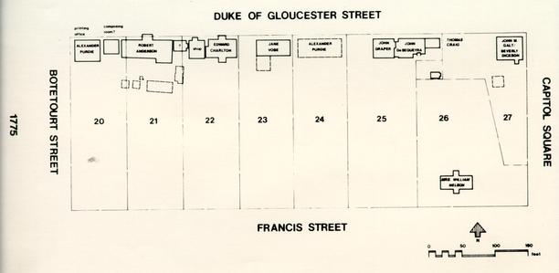 Figure 12. Block 9 in 1775.
32
Charltons were thinking of leaving for England, advertising their house for sale or rent.45 It failed to sell, however, and Edward Charlton remained on the property for several more years. He apparently lived in the structure now known as the Charlton House, using a small 26 by 30 foot building to the west (Noël Hume's Building East B) as a barber's shop. Archaeological investigations in the area of the shop produced a large number of wig curlers, probably confirming this interpretation.46 (Incidentally, wig curlers were also found around Building East A, the dwelling thought to have been occupied some years earlier by barber James Martin.) Building East B had probably been previously occupied by tailor James Slate, who in July 1774 advertised that he was at the "second door below Mr. Anderson's Tavern."47
Figure 12. Block 9 in 1775.
32
Charltons were thinking of leaving for England, advertising their house for sale or rent.45 It failed to sell, however, and Edward Charlton remained on the property for several more years. He apparently lived in the structure now known as the Charlton House, using a small 26 by 30 foot building to the west (Noël Hume's Building East B) as a barber's shop. Archaeological investigations in the area of the shop produced a large number of wig curlers, probably confirming this interpretation.46 (Incidentally, wig curlers were also found around Building East A, the dwelling thought to have been occupied some years earlier by barber James Martin.) Building East B had probably been previously occupied by tailor James Slate, who in July 1774 advertised that he was at the "second door below Mr. Anderson's Tavern."47
It was right before the Revolution that lot 23 became, for the first time, the site of a tavern. On February 6, 1772, Jane Vobe advertised that she was operating a tavern "opposite to the Raleigh, at the Sign of the King's Arms."48 Vobe was already a popular tavern keeper, and there are numerous references to her large and wealthy clientele. Once on the property Vobe probably used John Carter's former shop/dwelling as her tavern building, possibly enlarging it by adding a 21 by 24 foot addition to the west and, possibly, a southward extending ell addition.
Carpenter and brick mason Humphrey Harwood made repairs and additions to the property throughout Vobe's occupancy. His records indicate that she had up to fourteen rooms, four passages, and two porches, along with a kitchen, cellar, laundry, storehouse, shop, and well.49 It is likely that the outbuilding foundations behind the house were obliterated when the area was plowed by the Colonial Williamsburg Landscape Department, before archaeological investigations were carried out.
Lot 24 continued in the possession of printer Alexander Purdie, who had purchased the property for £300 in 1767. By 1772 Purdie's wife Mary, a milliner, had died, and in that year he married Peachy Davenport. Purdie and his new wife lived on the property until his death in 1779. In the two years prior to his death he had numerous repairs made to his dwelling, and these records show that it was composed of at least eight rooms, two passages, and a closet, with outbuildings including a kitchen, laundry, and office. A dairy and necessary house also appear to have been present. Archaeological crosstrenching of the back yard of the house revealed four colonial outbuilding foundations aligned almost perfectly on a north-south axis: a 6.5 by 8 foot structure, a 9.5 by 16 foot structure, a 6.3 by 5.9 foot well, and an 8.3 by 10 foot structure.50
East of the Draper/de Sequeyra tenement was the former Palmer House, rented in 1769 by cabinetmaker Benjamin Bucktrout.51 Bucktrout's lease was apparently taken up by Dr. John Minson Galt, 33 who kept a shop in one part of the house. Dr. Galt was still in the house in 1772, when he advertised:
[April 23, 1772]
Dr. KEYSER'S famous PILLS are to be had, with full Directions for their Use in all Cases, at JOHN M. GALT'S Shop, near the Capitol, in Williamsburg … (Virginia Gazette, April 23, 1772)
In December 1770 another part of the house was rented to merchant Beverly Dickson, who operated a store on the property, probably out of his part of the house. Dickson remained on the property through 1773, when Palmer's heirs first offered the house and lots for sale:
As the advertisement indicates, the brick dwelling house was accompanied by a small wooden outbuilding, probably the 18 by 24 foot structure shown on the plan of archaeological excavations.52 Though advertised again in 1775, the property was not sold until March 1780.[November 11, 1773]
THE LOTS near the Capitol in Williamsburg, held in Coparcenary by the orphans of the late John Palmer, whereon is an exceeding good Brick House two Stories high, also a small wooden One, very convenient for a Gentleman's Study, with two Rooms, all other necessary Outhouses, and a Garden. The Payments shall be made easy to the Purchaser, and a good Title when Possession is given, which will be on the 11th of January.
LEWIS TYLER (Virginia Gazette, Purdie & Dixon, eds., November 11, 1773)
The Nelson house on the southern side of lots 26 and 27 was probably owned and perhaps intermittently occupied by William Nelson until his death in 1772, after which it was probably inherited by his son Thomas. However, it is likely that the house was actually occupied by William's widow. The Nelsons continued to own the property throughout the Revolution.
The Years After the Revolution (1780-1800)
How long Draper and de Sequeyra occupied William Goodson's tenement is not surely known. By 1780 John Draper had come into "one lot... whereon the Old Play House lately stood."53 This lot was on Block 8, southeast of the Capitol, where Draper's dwelling house has since been reconstructed (Block 8, Bldg. 27). It is likely that Draper moved from Block 9 when he acquired this lot. The next tenant on lot 25, or Goodson himself, probably erected a long rectangular building on the western side of the lot, 34 partially obliterating Draper's westernmost forge. This building, partly uncovered by Noël Hume in 1958, is probably the structure shown in this location on the 1782 Frenchman's Map.
De Sequeyra probably lived at the tenement well into the 1780s. Mrs. Mary Goodson, widow of William Goodson (who died in 1781), was charged by Humphrey Harwood for numerous repairs to de Sequeyra's property between 1781 and 1785, and her estate was charged for similar repairs until 1790. It is also important to note that in 1785 General Thomas Nelson, owner of the property southeast of the tenement, was charged £-.7.6 for repair to "Doctr Sequary's Well."54 If, as archaeological evidence indicates, the first Draper/de Sequeyra well was filled by 1780, mostly using industrial waste from Draper's forges, this entry would seem to suggest that de Sequeyra later shared a second well with his neighbor Thomas Nelson. In any case it appears to clearly establish de Sequeyra on the property in 1785.
Thomas Craig's fate is much less clear. Craig's tailor shop occupied the small addition on the east side of the tenement in 1772, but virtually nothing is known about his later actions on the property. It is assumed, albeit without proof, that Craig left in the early 1770s and the addition was most likely taken over by de Sequeyra.
East of the tenement, the northern part of lots 26 and 27 continued to house one or more tenants at least until 1780, when William and Elizabeth Page purchased the lots. Page, possibly a merchant and clothes cleaner and dyer, conveyed the property in 1782 to merchants Jean Lewis Rey and Peter Dela Croix for £760 apiece.55 Rey apparently soon moved away, later deeding his share to merchant John Drewidz. Drewidz later was conveyed the remaining share by Peter Dela Croix.56 Between 1785 and 1787 Drewidz, who by then had been joined by London merchant Charles Hunt, paid Humphrey Harwood for major renovations associated with the construction of a snuff manufactory. (It is possible that the snuff-making operation was initially begun by Rey, a former snuff manufacturer in Petersburg.) The manufactory was probably housed in the basement or a nearby converted outbuilding, as archaeological excavations revealed nothing that could otherwise be construed as a manufactory building built specifically for that purpose.
Around 1786 Hunt and merchant Richard Adams took over the manufactory from Drewidz, later advertising:
Drewidz, apparently still the legal owner of the property, soon advertised for a public auction:[March 28, 1787]
SNUFF-MILLS
The proprietors of which, have for Sale, a large quantity of SCOTCH SNUFF, two years old, and by Judges 35 of that article, said to be fully equal to any imported from Europe. RAPPEE SNUFF superior to what can possibly cross the Atlantic. TWIST and SHAG for chewing, fine CUT for smoaking, to be had at the same Place. The Prices wholesale, are 25 per cent lower than any other State do furnish those articles for. All Orders addressed as above, due attention will be paid for Expedition and care in packing; by the Public's devoted Servants.
AT
WILLIAMSBURG
HUNT & ADAMS (Virginia Independent Chronicle, A. Davis, ed., March 28,1787)
It was not sold, though around 1789 Drewidz probably transferred title to Hunt and Adams. Hunt died by 1794, but his widow probably continued to live in the house. Adams had apparently by this time abandoned his claim. By 1798 Jane Hunt had married Jeremiah Barton, and the couple seem to have retained the property through the remainder of the 1790s.[August 30, 1787]
At public auction before the Rawleigh [Raleigh Tavern] door, on the second Monday in October next, at 3 o'clock in the afternoon,
MY HOUSE AND LOT, In THIS CITY
It is a large brick building, and so completely fixed either for a private Gentleman's family or a merchant, having thereon proper storehouses, I think a more particular description unnecessary, presuming any person inclinable to purchase will first view the premises. The terms of sale, on half cash, and the remainder payable in six months, the purchaser giving bond with approved security. Mess. HUNT & ADAMS, will attend the sale and make a title.
JOHN DREWIDZ (Virginia Gazette and Weekly Advertiser, Nicholson, ed., August 30, 1787)
The Nelson house apparently stayed in the Nelson family in the years following the Revolution. General Nelson's mother may well have lived, intermittently or continuously, on the property, as Humphrey Harwood carried accounts with Nelson in 1783-1785 for "taking down Grate & Plastering fire Place (for the Old Lady)," "5 bushs of lime... and 3 days labour... (for your mother)," and "Repairing Kitchin and landary (sic] Chimneys & Oven... /Old Lady."57 When General Nelson died in 1789, the property passed to his son Thomas Nelson III, who retained it the remainder of the century (see Figure 13). What architectural changes, if any, were made is at present unknown.
36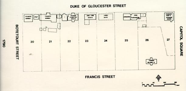 Figure 13. Block 9, in 1790.
The west side of Block 9 underwent more rapid change (see Figure 13). Alexander Purdie retained his printer's shop on lot 20 and his dwelling on lot 24 until his death in 1779. Upon his death, his nephew John Clarkson, in partnership with Augustine Davis, carried on Purdie's printing responsibilities. The Constitutional Post Office, like the printing press, remained on lot 20 until 1780, when the capital was moved to Richmond. As the office of the public printer was also moved, Clarkson and Davis seem to have vacated the premises soon after. In 1782 merchant Samuel Beall purchased the former printing office from Purdie's executors and former neighbors, John Minson Galt and Robert Anderson.58 Beall may have occupied the premises as early as 1779, in which case Clarkson and Davis must have for a short time done their printing out of the small building east of the storehouse, designated by Noël Hume as Building West A. An advertisement in 1779 notes that this was used as a "composing and press room."59
Beall probably did not occupy the property, which he used as a store, at his death in 1793, as his estate sale notice makes no mention of a storehouse.60 It appears that Beall sold his storehouse to William Rowsay by 1787, although land tax records suggest that Beall's estate was charged with the lot through 1802. By the 1780s Rowsay also owned lot 21, and it appears that for the rest of the century the two lots were once again united.
Robert Anderson kept his tavern on lot 21 until 1779, when it was taken over by Ambrose Davenport.61 Davenport's venture was short-lived, however, as by 1780 he was ready to sell out, perhaps motivated by the removal of the capital to Richmond and the exodus of much of his potential clientele. There is no firm evidence regarding the next tenant of lot 21, if any; the property, however, continued to be owned by Henry Nicolson, Wetherburn's heir. Indirect evidence suggests the possibility that by 1783 the tavern was run by Ann Craig, widow of the Thomas Craig who eleven years earlier had occupied the shop east of the Draper/de Sequeyra tenement.62
On September 5, 1783, Henry Nicolson conveyed a tenement "adjoining to the Store of Samuel Beall, esquire on the West, and to another Tenement belonging to the said Henry Nicolson on the east" to James Davis.63 This was most probably Building West A, situated between Beall's store and Robert Anderson's former tavern. Apparently Davis was only leasing the tenement through 1786, as by 1785 jeweler William Rowsay had purchased both lots 20 and 21 from Henry Nicolson. Rowsay, who may have had a jewelry shop in a rented Building East A in 1774,64 also owned lots on Palace Street. In 1784 he was named Notary Public, replacing a Colonel James Innes, who had an office "on the main street, nearly opposite the Raleigh Tavern."65 This may well refer to part of Anderson's former tavern, then apparently also occupied by Ann Craig, or perhaps to an outbuilding elsewhere on the property.
38Rowsay at least for a time lived in the tavern building, but in 1786 decided to leave the area. His advertisement of sale states that the "houses and out-houses are now in good repair, and the lot under an excellent plank enclosure."66 Rowsay could not sell the house by his death around 1787. His wife Frances (later married to Benjamin Powell) apparently owned and possibly occupied the property through the remainder of the century.
At the end of the Revolution lot 22 was still in the possession of the Charlton family. Edward and Jane Charlton probably left the state in 1779, leaving their house and property to Sarah Charlton, widow of Richard Charlton and possibly Edward's sister-in-law (it being assumed that Edward and Richard were brothers). Sarah apparently moved into the property around 1780 and lived there through 1788. Richard Charlton's estate continued to own the property until 1795, when it was conveyed to City Clerk William Russell, whose wife was a relative of Jane Charlton. Russell maintained the property through the remainder of the century.
In 1796 a Mutual Assurance Society policy describes the standing buildings: a 44 by 29 foot two-story dwelling, a 30 by 26 foot one-story office less than twelve feet away, and a 22 by 18 foot kitchen.67 These are apparently the Charlton House itself, Building East B (Charlton's barber shop), and the now reconstructed Charlton Kitchen, respectively.
Lot 23 was the site of the King's Arms Tavern, run by Jane Vobe until 1787. Vobe advertised the property for sale as early as 1785, but it had not been sold by the time of her death two years later. Vobe's estate retained the lot until 1795, when it was apparently sold to James Ruffin. Ruffin soon transferred the property to Philip Moody, as in 1796 Moody is charged in land tax records for one lot valued at £45. When Moody insured the property that same year, the establishment had become known as the "Eagle Tavern." It is shown as consisting of a 57 by 24 foot building with a 34 by 57 foot south wing, a 16 by 20 foot barber shop to the east, a 16 by 50 foot kitchen to the south, and a 28 by 54 foot stable on the back of the property (near Francis Street).68 Archaeological excavations and subsequent insurance documents indicate that the directions on this first policy were probably reversed, and that the barber shop was actually west of the house, next to lot 22. In any case Philip Moody retained the property through the end of the 18th century.
When Alexander Purdie died in 1779, his dwelling house on lot 24 was put up for sale. The purchaser was Thomas Cartwright, a former ordinary keeper in James City County.69 It is not clear whether Cartwright ever occupied the property, however, before his death in 1782. In 1783 his son's attorney advertised the property for sale: 39
Mention of the kitchen, stable, and "other convenient outhouses" suggests that many if not all of Purdie's outbuildings were still standing at the time.[October 18, 1783]
BETWEEN the hours of two and three o'clock in the afternoon, on the second Monday in January next, before the Raleigh-Tavern door (if not before that time disposed of at private sale) by virtue of a power of attorney from Thomas Cartwright to the subscriber, the said Cartwright's LOT and HOUSES in Williamsburg, viz. a large commodious dwelling-house, with four rooms on a floor, a kitchen, stable, and other convenient outhouses, situate on the main street, between Mrs. Vobe's and the capitol. One half the purchase money to be paid at the sale, when a title will be made; the other half at the end of six months, on giving bond with approved security to
ALLEN JONES. (Virginia Gazette or American Advertiser, Hayes, ed., October 18, 1783)
The lot was purchased by Sheldon Moss of Warwick County, but Moss apparently failed to complete the payments, for on February 17 1786, Moss and Jones jointly conveyed the lot to tailor James Davis.70 Davis, formerly leasee of lot 20, advertised the property for sale only a year later:
It failed to sell, but by 1794 it was being rented by Judge Cyrus Griffin. Another advertisement for sale indicates that the property by then contained a "Kitchen, Launtry [sic), Dairy, Smokehouse, Granary, Stable and Chariot-House; an Excellent Well of Water in the yard; [and] a large Garden well enclosed."7l In 1796 Davis insured the property, but showed only a 26 by 58 foot dwelling, a 16 by 34 foot kitchen, and a 20 by 24 foot stable.72 Apparently Davis retained ownership of the property until 1803.[February 22, 1787]
FOR SALE
THE SUBSCRIBER'S HOUSES & LOT,
In the City of Williamsburg, Formerly the property of
Mr. THOMAS CARTWRIGHTThe dwelling house is a commodious building, having six rooms below stairs, with fire places also, good dry cellars, and all convenient out houses, with a stable and carriage house, all in good repair, a large garden, newly inclosed, and a well of excellent water in the yard. Any person purchasing the house, may if agreeable, have the furniture at a reasonable rate,
ALSO FOR SALE
A neat single CHAIR & HARNESS, and a NEGRO FELLOW,
Who is a very good tailor, For terms apply to
JAMES DAVIS.
I HAVE A FEW BROADCLOTHS, AND OTHER DRY GOODS, which I will sell cheap for CASH or TOBACCO.
J.D.All persons indebted to me, by bond or open account, are requested to make immediate payment, no longer indulgence can be given; and those who have demands 40 against me, are desired to make them known, that provision may be made for discharging them.
(Virginia Gazette or American Advertiser, Nicholson, ed., February 22, 1787)
JAMES DAVIS.
The Nineteenth Century and Later
Although this composite history covers only the period between 1700 and 1800, it is important to note that later structural modifications and ownership changes left their mark on the available archaeological evidence as well.
In 1799 the Shields Tavern property, along with other property owned by the Goodson estate, was offered for sale:
THE SUBSCRIBERThe Shields Tavern property was not sold until between 1801 and 1806, when ¾ of lot 25 was conveyed to Peter Powell, then owner of lot 52 across the street. The remaining ¼ lot was passed to John Coke, who by that time also owned lot 24. An 1809 insurance policy on lot 24 gives, as an eastern boundary, "Powells and J 41 Cokes lot and office."73 As interpreted, this indicates that Coke had an office on the western ¼ of lot 25, the remainder of which was in Powell's possession. It is this "office" that has been reconstructed, but it is important to remember that the John Coke office, and its fenced surroundings, undoubtedly reflect conditions after Coke acquired the property around 1806.
Offers for SALE, on reasonable terms... two HOUSES and LOTS,
IN the city of Williamsburg: one of them is situated on the main street, near the capitol, and is well calculated for a private dwelling or a store; it has a small garden which may be inclosed at a small expence. The other is situated on the road leading from Williamsburg to York, has the advantage of a large garden, and a rich, fertile lot adjoining - bonds with approved security will be required for the payment and no deed will be made for the property till the terms of sale have been completed. The terms will be made known by applying to me in this city [Richmond] or to Mr. W. Whitaker in Williamsburg, who will also shew the houses to any person disposed to purchase.
WILLIAM GOODSON [II] (The Virginia Gazette and General Advertiser, September 10, 1799)
The discovery by Pat Gibbs of the Colonial Williamsburg Foundation's Research Department of an unnumbered 1813 insurance policy on Powell's lot sheds further light on 19th-century activities there.74 The plat shows what appears to be the eastern half of the former Shields Tavern with the shed on the east, here labelled as a 14 by 14 foot kitchen. A smokehouse is shown south of the kitchen, in the general area of the reconstructed Stillhouse and Dairy. It seems likely that one of these buildings is in fact the smokehouse, and that the other was probably constructed after the issuance of this insurance policy. If the de Sequeyra period exterior kitchen is represented archaeologically by a partial foundation uncovered in this same area, it would appear that the Stillhouse and/or Dairy are in fact post-colonial features that, although shown overlying what would have been the kitchen's foundation wall, actually cut through and partially obliterate the kitchen's foundation.
The policy also shows that the lot line had apparently shifted westward to its present location, crossing the house in the area around the double chimney. The eastern half of the house, the area insured, would have now comprised lot 26, while the western half, referred to as "Sands' lot," would have comprised lot 25. How "Sands," assumed to be carpenter Thomas Sands, acquired lot 25 is presently unclear.
The other 19th-century alterations of the Block 9 landscape and community are too numerous to be covered here. In any case, the College Map (1791?), the Bucktrout Map (1800/03), and the much later oral histories in the "Recollections of Williamsburg" report provide fairly clear pictures of the 19th-century social context.75 I hope that this report has cleared up the picture, at least a little, for the 18th century as well.
Footnotes
42- Stephenson, Mary A., "Tarpley's Store: Block 9, Lot 20" (Research report, Colonial Williamsburg Foundation [CWF], May 1958.
- Gibbs, Patricia A., "Mr. Wetherburn's Tavern: Block 9, Colonial Lots 20 & 21" (Research report, CWF, May 1974)
- Stephenson, Mary A., "Charlton House: Block 9, Colonial Lot 22" (Research report, CWF, October 1957)
- Stephenson, Mary A., "King's Arms Tavern (Block 9, Colonial Lot 23)" (Research report, CWF, July 1949)
- Stephenson, Mary A., "Purdie's Dwelling: Block 9, Colonial Lot 24", (Research report, CWF, January 1958)
- Goodwin, Mary R., "'Marot's' or 'The English Coffee House'" (Research report, CWF, November 1951)
- Goodwin, Mary R., "The Walthoe House: Block 9- Portion of Lots #26 and #27" (Research report, CWF, December 1950)
- Stephenson, Mary A., "Palmer House: Block 9, Colonial Lot 27 (north)" (Research report, CWF, January 1960)
- Stephenson, Mary A., "History of the Nelson-Galt House (Robertson House)" (Research report, CWF, November 1945)
- Kirk, Glenn, "The Charlton Site. Block 9, Area P, Colonial Lot 22: Report of the 1966 Archaeological Findings" (Archaeological report, CWF, June 1967)
- Noël Hume, Ivor, "Archaeological Excavations on Colonial Lots 21 and Parts of Lots 20 & 22. Wetherburn's Tavern. 1965-1966: Interim Report" (Archaeological report, CWF, April 1968)
- Campbell, George S., "Archaeological Survey of Foundations on Block 9. Colonial Lot No 20." Block 9, Area C (Map, CWF, October 1935)
- Knight, James M., "Archaeological Survey of Foundations of King's Arms Barber Shop and Remains of Early Kitchen Foundation on Col. Lot 23, Williamsburg, Va." Block 9, Area E (Map, CWF, June 1941)
- Knight, James M., "Archaeological Survey of Foundations of King's Arms Tavern- Uncovered in Williamsburg, Virginia, 1932." Block 9, Area A (Map, CWF, August 1932)
- Knight, James M., "Archaeological Survey of Foundations on South End of Colonial Lots 22 & 23, Williamsburg, Va." Block 9, Areas H & D (Map, CWF, January 1942) 43
- Knight, James M., "Archaeological Survey of Foundations of Purdie House on Col. Lot 24, Williamsburg, Va." Block 9, Area F (Map, CWF, March 1941)
- Knight, James M., "Archaeological Survey of Foundations on Marot's Ordinary, Williamsburg, Va." Block 9, Area L (Map, CWF, June 1954)
- Knight, James M., "Archaeological Survey of Foundations on Kerr Property, Williamsburg, Virginia." Block 9, Area B (Map, CWF, August 1953)
- Knight, James M., "Archaeological Survey of Foundations on Robertson-Galt Property (Part of Colonial Lots No. 26 & 27), Williamsburg, Va." Block 9, Area J (Map, CWF, July 1951)
[January 22, 1707/8]
[Feoffes of Williamsburg
... do Grant Bargain Sell remiss Release & Confirm unto this said William Robertson Two Certain Lotts of Ground in the Said City of Wmsburgh designed in the plott of the said City by these figures (26) and (27) with all Woods thereon Growing or being together with all profitts Comodities Emoluments & Advantages Whatsoever to the same belonging or in any Wise Appertaining TO HAVE AND TO HOLD... for ever... under the Limitations & Reservations hereafter Monconed... (that is to Say) that the said William Robertson his heirs or Assigns shall not in the Space of Twenty four Months, next ensueing the date of these presents begin to build & finish upon Each Lott of the said Granted premisses one Good Dwelling house or houses of Such Dimensions and to be plased [sic] in Such Manner as by One Act of Assembly made at the Capitol the 23d of October 1705... IN WITNESS thereof Mongo Ingles & Hugh Norvell Gents Two or the said feoffes or Trustees have set their hands & Seals the day & Year above Written. Mongo Ingles (Seal)
to
William Robertson of James City County
Consideration: 30 shillings of good and lawful money of England]
Hugh Norvell (Seal)
(Recorded York County Court Feb. 24, 1707/8) (York County Records, Deeds & Bonds, Book II, p. 268)
THIS INDENTURE made the Twenty fourth day of January... 1707[/08] BETWEEN James Sheils of the County of James City Taylor & Hannah his wife of the one part And John Marott of the County of York of the other part WITNESSETH that the said James Sheils & Hanah his wife for & in consideration of the Sum of fifty pounds Sterg unto them or one of them in hand paid by the Said John Marott before the Ensealing & Delivery of these presents the Receipt whereof they do hereby Acknowledge... HAVE Granted Bargained Sold... unto the Said John Marott... ALL that Lott of Ground lying & being in the City of Williamsburgh on the South Side of Duke of Gloucester Street designed in the plott of the Said City by the figure (25) which Said Lott Lyes Contiguous to the Lott formerly Sold by the Said James Shels [sic] to William Byrd Esqr together with all Houses Edifices, buildings Yards... To HAVE AND TO HOLD the Said Lott Houses & all & singular other premises herein before mentioned... IN WITNESS whereof the Said James Sheil, & Hanah his wife have hereunto Sett their hand & Seales the day & year first above written.
The mark of
(York County Records, Deeds, Book II, pp. 262-264)
James J S Sheils [seal]
Hannah Sheils [seal]
At a Court held for York
County the 24th day of
January 1707[/08]
... one certain piece of land... on the South side of the Duke of Gloucester Street, containing forty foot square, being part of that lot of ground... described... by the figures 26, and bounded on the North by the said [Duke of Gloucester] street, on the West by the lot of ground belonging to the said Marott, and on the South and East by the said William Robertson's lots. (York County Records, Deeds, Book II, p. 295)
[May 23, 1716]
[Richard Bland of Prince George County
to
Colonel Nathaniel Harrison of Surry County
Consideration: £100 current money of Virginia]THIS INDENTURE made this 23rd day of May... 1716 between Richd Bland of Prince George County of the one part & ye Honble Coll. Nathl. Harrison of Surry County of the other part Witnesseth that the sd Richd Bland for and in consideration of ye rents and covenants hereafter named... hath demised granted lett leased &... by these presents... the Two Lotts or half Acres of 45 Land, - - - in ye City of Wmsburgh of which he [Bland] lately lived upon the south Side of Duke of Gloucester Street designed in ye Plott or draught of ye sd City by ye Numbers or Figures (20 & 21) together with all houses... gardens... To have and to Hold ye sd Two Lotts... & appurtenances unto ye sd Nathl Harrison his heirs & Assigns for Ever...
Richd Bland (Seal)Signed, Sealed & Delivered in presence of
M Ingles
Benj Weldon
ffran Tyler
Tho: Mitchell
James Shield
Jno Blair
Joseph DavenportAt a Court for York County 18th June 1716
(York County Records, Deeds & Bonds, Book III, pp. 19-20)
Robertson, William - Gent
All that dwelling house with the outhouses thereunto belonging wherein the said William Robertson lately dwelt together with the Garden Yard & appurtenances, being part of two lots of ground denoted in the plan of the said city by the figures 26 and 27, bounded on the South by the Street called Francis Street, on the East by the Capitol Square, and part of the said lots formerly sold to Dr. John Brown on ye North by other part of lots sold to said Brown and to John Marot, dec'd, and on the West by the lots late of said John Marot and now in the tenure and occupation of Anne Sullivan[t] together with all buildings Yards Orchards, proffits .... (York County Records, Deeds & Bonds, Book III, p. 411)
to
December 12, 1723 Grymes, John - Esq.
of Middlesex
Consideration: 200 Pounds Lawful money of Great Britain
[June 15, 1730]
THIS INDENTURE made the fifteenth day of June in the year of Our Lord MDCCXXX BETWEEN Henry Willis Gent and Mildred his wife, John Holloway Esqr & Richard Hickman Gent Executors of the last Will and Testament of John Brown Gent decd on the one part and John Stott of Williamsburgh Watchmaker of the other part WITNESSETH That the said Henry Willis and Mildred his wife, John Holloway and Richard Hickman... for and in consideration of the Sum of Thirty five pounds Curt money of Virginia to them paid by the said John Stott... the receipt whereof they... do hereby acknowledge... do grant bargain sell ... unto the said John Stott and his heirs one piece or parcel [ ... con]taining Three thousand nine hundred & sixty eight [ ... ] and being on the South side of Duke of Gl[oucester ... ] Williamsburgh binding on the said Street 46 and the [ ... ] Esqr and James Ingles and the la[ ... ] tor Brown lately lived and all and [ ... bui]ldings thereon erected and being and also the [ ... ]ions Remainder and Remainders Rights [ ... To Have and to] hold the said piece or parcel of land and all [ ... ] the premises herein before mentioned and [ ... ] hereby granted with their and every of their appurtenances unto the said John Stott... (York County Records, Deeds, Book IV, pp. 42-43)
[July 1, 1732]
THIS INDENTURE made the first day of July in the Sixth Year of the Reign of Our Sovreign Lord GEORGE the Second by the Grace of God of Great Britain France and Ireland King defender of the faith and ca and in the Year of our Lord MDCCXXXII, BETWEEN Henry Willis of the County of Spotsylvania Gent & Mildred his wife and John Holloway of the City of Williamsburgh Esqr Surviving Executors of the last Will and Testament of John Brown late of the said City deceased of the one part And Alexander Kerr of the said City Gent of the other part WITNESSETH That Whereas the above named John Brown was in his life time Seized in Fee of and in one Messuage Garden & out houses lying and being in the said City of Wmsburgh Upon Duke of Gloucester Street and being so Seized made his last Will and Testament in Wrighting bearing date the Eighth day of September MDCCXXII, and thereby did devise in the Words following Vizt, Item my Will is that my Execurs hereafter named three Years after my decease do sell my land and Houses in Williamsburgh to any person that Will purchase the same in Fee for the best price they can and that in the mean time my said Wife shall have the Use thereof And of his last said Will did Constitute the said Mildred then his Wife the said John Holloway & Richard Hickman now deceased his Execrs as by his said Will (Relation being thereunto had) may more fully appear And whereas the said Mildred hath Enjoyed the said House and land with the Appurtenances for and during the space of three Years after the date of the said Testator they the said Henry Willis & Mildred his wife & the said John Holloway Esqr ins pursuance of the said Will and for and in Consideration of the Sum of One hundred pounds Currt Money of Virginia to them in hand paid Or Secured to be paid by the said Alexander Kerr the Receipt Whereof they do hereby Acknowledge (being the best price that could be got for the premisses) have Granted Bargained and Sold... Unto the said Alexander Kerr All that Messuage or Dwelling House with the Garden or Piece of Ground thereto belonging lying and being in the said City of Williamsburgh and bounded on the North by Duke of Gloucester Street on the East by the Capitol Square on the South by part of the Lotts of John Grymes Esqr and on the West by the Lotts of the said John Grymes and that piece of Ground lately Sold by the Execus to John Stott of the said City Watchmaker with all Houses outhouses Gardens Profits Easements & Hereditaments... To have and to hold... for EverSealed and Delivered in the presence of
Henry Willis S
Mildd Willis S
John Holloway S
47 Frans Fontain
Charles Brown
John Stott[Recorded York County court
(York County Records, Deeds, Book IV, pp. 150-151)
Dec. 18, 1732]
[May 13, 1749]
... one certain messuage Piece or Parcel of Land containing Three Thousand nine hundred Sixty-eight Square feet lying and being on the South side of Duke of Gloucester Street... binding on the said Street and the Lands of William & Thomas Nelson, Esqrs John Palmer and James Shields which said Messuage... Piece... of Land the said John Stott purchased of Henry Willis and Mildred his wife John Holloway Esqr and Richard Hickman Executors of the last will and Testament of John Brown Gent deced who conveyed the same to him by Indenture bearing Date the fifteenth Day of June in the year of our Lord one thousand seven hundred & thirty Recorded in the Court of York County and so being seized the said John Stott by his last will and Testament in writing bearing Date the Ninth Day of November... one thousand seven hundred and forty eight did devise the said Premises by the Description of his Houses in Williamsburgh with all the Ground thereunto belonging unto his said Executors... in Trust to be by them Sold... for the Purposes mentioned in his said Will AND WHEREAS Lewis Burwell purchased 48 the said Premises at Public Auction being the highest Bidder for one hundred and sixteen pounds current money to the sd William Prentis and Peter Scott Have granted... sold... unto the said Lewis Burwell all the aforesaid Messuage Piece or Parcel of Land and all Houses out Houses .... Received this Thirteenth Day of May 1749 of the within mentioned Lewis Burwell ... £116 C. M . .... (York County Records, Deeds, Book V, pp. 288-290)
[January 21, 1750/1]
... All that Messuage piece or parcel of Land containing three Thousand nine hundred and Sixty Eight Square Feet lying and being on the South side of Duke of Gloucester Street in the City of Williamsburgh binding on the said Street and the Lands of William and Thomas Nelson Esqrs. John Palmer and James Shields Deced which said messuage Piece or Parcel of Land was Sold unto the said Lewis Burwell by William Prentis and Peter Scott, Executors of the last Will and Testament of John Stott Decd by Indenture bearing Date the thirteenth day of May one thousand seven hundred and forty nine... and all Houses out Houses .... RECEIVED January the Twenty first, 1750/[l] of the within named Nathaniel Walthoe the Sum of... £120.... (York County Records, Deeds, Book V, pp. 413-415)
[August 23, 1759]
[Henry Wetherburn of the City of Williamsburgh, Tavern Keeper and Anne his wife
. . . a certain Part or piece of a Lot of Ground belonging to the 49 said Henry Wetherburn Situate Lying and being on the South Side of the Main or Duke of Gloucester Street in the said [city] of Williamsburgh denoted in the Plan of the said City by the Figures 20, to begin at the North west Corner of the said Lot and thence to Run Eastwardly and along the line of the said Lot on the said main Street Forty feet for Front thence Southerly into the said Lot Fifty Six Feet by a Line Paralel to the Street marked in the Plan of the said City by the letter L Thence Westerly Forty feet a Paralel Line to the first Course and thence Northwardly along the west Side of the said Lot to the Begining And all Buildings...
to
James Tarpley, merchant of the City
Consideration: 120£ current money of Virginia]
Henry Wetherburn[Recorded York County]
(York County Records, Deeds, Book VI, p. 212)
[February 12, 1767]
To be SOLD, by Private sale,
A VERY HANDSOME AND CONVENIENT STOREHOUSE on the main street in Williamsburg, with every advantage from its situation either for a merchant or tradesman, and is in exceeding good repair, having been built but a short time. The credit will be agreed on at the day of sale, the purchaser giving bond and security to
JOHN THOMPSON, & Co. (Virginia Gazette, February 12, 1767)
[Will of Joanna McKenzie] [1766/67]
... It is my will and desire that my whole estate both real and personal be sold as soon after my death as conveniently may be for the payment of my just debts excepting six silver table spoons ten silver tea spoons and all my ribbon and cap wire and the other things belonging to my milenary [ ... ] which things above excepted I do give and bequeath to my daughter Ann All the residue of my estate both real and personal [ ... ] equal [ ... ] year of our Lord 1766.
Joanna McKenzie[Recorded York County Court
(York County Records, Wills & Inventories, Book XXI, p. 294)
January 19, 1767]
McKenzie, Joanna - widow
All that Lott or half Acre of Land lying and being in the City 50 of Williamsburg on the South Side of Duke of Gloucester Street bounded on the North by the said Street on the West by the Lott of Mr John Carter on the South by Francis Street and on the East by a Lott of Mr. James Sheilds and all houses Buildings Yards Gardens Privileges Profits Commodities Hereditaments and Appurtenances whatsoever .... (York County Records, Deeds, Book VI, p. 301)
to
Carter, James - Surgeon
Consideration: 216 pounds secured to George Washington, Esq.
(James Carter bound with said Joanna)
[March 1, 1759]
... All that Piece or parcel of Land containing three thousand nine hundred sixty eight Square feet Situate on the South side of Duke of Gloucester Street... bounded by the said Street and the Lands of William & Thomas Nelson Esqrs the said John Palmer and James Sheilds, decd which said... Land was Sold & Conveyed unto said Walthoe by Lewis Burwell of County of James City Gent... and all houses Conveniencies and appurtenances whatever to the said Premises in any manner appertaining ....[Receit of £60 acknowledged March 1, 1759 by Nathaniel Walthoe.]
(York County Records, Deeds, Book VI, pp. 187-188)
[June 2, 1774]
ROBERT BRUCE, WATCH and CLOCK maker, is removed from Mr. Craig's, at the Golden Ball, to the opposite Side of the Street, the House above Mr. Robert Anderson's; where he intends carrying on his Business, and will be much obliged to those who may please to employ him. (Virginia Gazette, June 2, 1774)
WILLIAMSBURG, February 28, 1771
THE SUBSCRIBER HAS TAKEN THE HOUSE LATELY occupied by Mr. Southall, where he hopes to be prepared, by the ensueing General Court, for the Accomodation of Gentlemen. He returns Thanks to those Gentlemen who have formerly frequented his House, and hopes to merit a Continuance of their Custom.
ROBERT ANDERSON.
N.B. A single Man, well recommended, who understands the Business of a Bar, will have Employment by applying to me. (Virginia Gazette, Purdie & Dixon, eds., February 28, 1771)
[November 4, 1774]
THE subscriber intending for ENGLAND, would be glad to dispose of the house he now lives in, with the lot and other improvements thereon; the situation is in the most public part of 51 the city and the house well calculated for any business. To any person inclining to become a purchaser the payments will be made easy, on giving bond, and good security; or it will be sold on an annuity, as may best suit the parties.
EDWARD CHARLTON (Virginia Gazette, Pickney, ed., November 4, 1774)
To be RENTED, and entered on the 15th of May next, THE lease of a large and commodious BRICK HOUSE, opposite to the coffee-house and nigh the Capitol. It has every necessary convenience, is very fit for a tavern or for taking in private lodgers, and has been long used by many Gentlemen in Assembly and Court times.
There are four years of the lease unexpired, about the last of April next.
I would also sell the FURNITURE as it stands, at a fair appraisement.
BENJAMIN BUCKTROUT. (Virginia Gazette, Purdie & Dixon, eds., February 2, 1769)
[August 16, 1782]
[William Page, merchant and Elizabeth, his wife,
... all that Lot or parcel of Land situate lying and being on the South side of the Duke of Gloucester Street in the said City of Williamsburg and bounded on the North by the said Duke of Gloucester Street on the West by the Lotts of William Nelson dec'd on the South by the Lotts of the Honble Thomas Nelson esquire and on the East by the Capitol Square it being the same Lott or parcel 52 of Land that belonged to John Parmer [Palmer] deceased and at his death descended, to his Children Elizabeth Catherine & Mary Barradall and by the said Children sold and conveyed to the aforesaid William Page... with all Houses Buildings ....
to
Jean Lewis Rey and Peter de La Croix, merchants
Consideration: 760 Pounds apiece][Recorded: York County Court
(York County Records, Deeds, Book VI, pp. 128-130)
August 17, 1782]
[September 7, 1782]
[Peter de La Croix, merchant, Williamsburg
... one equal Moiety of half part of all that Lott or half Acre of Land situate lying and being on the South side of Duke of Gloucester Street in the said City of Williamsburg and bounded as followeth on the North by the said Duke of Gloucester Street on the West by the Lots of William Goodson deceased on the South by the Lot of Thomas Nelson Esquire on the East by the Capitol square being the Lot or parcel of Land purchased by and conveyed to the said Peter Dela Croix and Jean Louis Rey by William Page and Elizabeth his wife late of the City of Williamsburg Merchant and by the said Page purchased of Richard Booker and Elizabeth his wife, Joseph Fuqua Junior and Catherine his Wife and Peter Stubbs and Mary Barradall his Wife as by their joint conveyance... March 15, 1780... with all Houses Buildings yards .... (York County Records, Deeds, Book VI, pp. 134-135)
to
John Drewitz (Drewidz) merchant,
Consideration: £375 Current Money of Virginia]
[Consideration: 3000 Pounds paper Currency of Virginia, September 30, 1782]
… Between John Minson Galt and Robert Anderson Executors of the last Will and Testament of Alexander Purdie… and Samuel Beall, (Williamsburg] Merchant… All that piece or parcel of Land situate lying and being in the County of York and said City of Williamsburg being part of that Lott or half acre of Land denoted in the plan thereof by the figure or Number 26 and bounded on the North by Duke of Gloucester Street on the East by the Lott of Henry Nicholson on the South by the said Nicholsons Lott and on the West by Pump Street being the Peice or Parcel of Land now in the Tenure and Possession of the said Samuel Beall and which was sold and conveyed by Messieurs Tarpley and Thompson Merchants to James Pride of the County of James City and by the said [James] Pride… by Deed bearing date the seventeenth day of September one Thousand seven hundred and eighty two and all Houses …[Recorded October 21, 1782]
(York County Records, Deeds, Book VI, pp. 140-141)
[December 6, 1793]
To be Sold,
Situate in Williamsburg The House and Plantation late the property of Mr. Samuel Beall, decd. The Land contains about 400 acres, part meadow, the remainder fit for the culture of tobacco, corn or any kind of grain.The House is very commodious, replete with out Houses for servants and all convenient and useful offices, near it are springs producing excellent water in great abundance. The garden is large, abounding with fruit and vegetables. Situate in an excellent neighborhood, this estate comprises a profitable and delightful residence for a genteel family.
For particulars apply to Benjamin Waller, Esq; in Williamsburg.
(Virginia Gazette and Weekly Advertiser, Nicholson, ed., December 6, 1793)
WILLIAMSBURG, September 25, 1779.
THE subscriber begs leave to inform the publick in general, and his friends in particular, that he has opened TAVERN in the house formerly occupied by Captain Robert Anderson. Gentlemen who favour him with their custom, may depend on his utmost endeavors to give satisfaction.
AMBROSE DAVENPORT. (Virginia Gazette, Dixon & Nicholson, eds., September 25, 1779)
| 1783 | Henry Nicolson, and Mrs Ann Craig | Dr |
|---|---|---|
| Novr 11 | . . . | |
| To whitewashing 3 rooms a 4/16 | ||
| & a large Room 10/ ------------- | 1.8.6 | |
| . . . | ||
| To laying a hearth in Bull head | ||
| 2/6 & a tag down Grate -------- | -.5.1 |
It is presumed that the linking of the two names indicates Nicolson's ownership and Ann Craig's occupancy of the property.
In the same year Alexander Macauley's journal describes a "Mrs. Craig's" house:
... Miss Molly followed us to the Door, and told us Mrs. Craig was the only Lady in Town who kept a publick House; I thank'd her for her information, & to reward her shall direct my Brother Peter to give her a call the first time he comes to Williamsburg. Perhaps he may be of some service to her. We drove to Mrs Craigs, whose appearance prepossessed us in her favour as much as Mrs54 Campbells had against her; We met here with Col. Monroe, one of the Honorable Council, who appear'd to be a modest, well-behav'd Man, But Rather young for a Councellor; The good Land-lady was extremely kind, gave us a good Dinner, was at pains to send all over the Town untill she procured some Oysters for Bettsey, entertained us with a degree of good nature which is peculair to Fat people; you probably know her, she is exactly shap'd like a Rum Hdd; she play'd a good knife & forke, & had no objection to a glass of genuine Port, which I assure you did not come amiss to some of the rest of the Company. At four o'clock we bid adieu to our Landlady, after assuring her that should we come to Williamsburg again, we would most certainly have the pleasure of waiting on her. We arrived at this place [Yorktown] with daylight .... ("Journal of Alexander Macauley," William and Mary Quarterly, lst series, Volume XI, pp. 183-191)
[September 5, 1783]
[Henry Nicolson and Sarah, his wife,
to
James Davis, tailor,
Consideration: £90]THIS INDENTURE made the fifth Day of September in the Year of our Lord one Thousand seven hundred and eighty three BETWEEN Henry Nicolson of Williamsburg in the State of Virginia, Planter, and Sarah his Wife, of the one part and James Davis of the same place Taylor, of the other part WITNESSETH that for and in Consideration of the sum of Ninety Pounds to the said Henry Nicolson in hand at or before the sealing and Delivery of these presents by the said James Davis well and truly paid, the receipt whereof is hereby acknowledged. They the said Henry Nicolson and Sarah his Wife have, and each of them hath, granted, bargained, sold, aliened, released and confirmed, and by these presents do, and each of them doth, grant, bargain... and confirm, unto the said James Davis his Heirs and assigns: all that Messuage or Tenement now in the Possession of the said James Davis, situate, standing and being in the City of Williamsburg aforesaid, adjoining to the Store of Samuel Beall esquire on the West, and to another Tenement belonging to the said Henry Nicolson on the east Together with all and singular the ways, passages, Waters, Water Courses, Lights, Easements, Profits, Priviledges, Advantages and Appurtenances, whatsoever, to the said premises belonging or in any wise appertaining and all the estate, Right, Title, Interest, property Claim and Demand, whatsoever, of them the said Henry Nicolson and Sarah his Wife, or either of them of in or to the same. To have and to hold the said Messuage or Tenement... unto the said James Davis his Heirs and assigns... for ever... IN WITNESS whereof the said parties to the presents have hereunto set their Hands and Seals the Day and Year above Written.
Henry Nicolson (LS)
55 Sarah Nicolson (LS)
Signed sealed and
Delivered in presence of
David Miller
William Rowsay
Samuel CrowleyReceived the day and year within written of the within named James Davis, Ninety Pounds in full for the Consideration within mentioned.
(York County Records, Deeds, Book VI, pp. 173-174)
Witness
Henry Nicolson.
[December 18, 1784]
His Excellency the Governor, in Council, having pleased to appoint me Notary Public, for the District of Williamsburg and York, in the place of James Innes, Esquire, who hath resigned; I therefore give this public notice, that I am ready to execute the several duties of the said office; and that the business will be conducted, at the office formerly occupied by colonel Innes, on the main street, nearly opposite the Raleigh tavern.
WILLIAM ROWSAY. (Virginia Gazette or American Advertiser, Hayes, ed., December 18, 1784)
May 31, 1786
The precarious state of the Subscriber's health has determined him to leave the state, and being largely indebted to Messrs. HUNT & ADAMS, and they pressing for payment, has compelled him however disagreeable, to deliver up and assign his store accounts over to them, with full power to sue and recover the same, in like manner that he himself lawfully could do…
…
(Virginia Gazette or American Advertiser, Hayes, ed., May 31, 1786)
The subscribers Houses and Lots on Palace-street, with the Lands and Negroes in York-County, advertised sometime past, are yet for sale. He would also willingly sell the house he now resides in, which was formerly a well frequented tavern, being the house on the main street, nearly opposite the Rawleigh, occupied by Mr. Southall, and afterwards by Mr. Anderson. The houses and out-houses are now in good repair, and the lot under an excellent plank enclosure.
WILLIAM ROWSAY.
[February 21, 1780]
[John Minson Galt
... All that Lot or parcel of Ground in the City of Williamsburgh on the South side of the Duke of Gloucester Street whereon the said Alexander Purdie in his lifetime resided and bounded on the East by the lot of William Goodson on the North by the Duke of Gloucester Street on the West by the Lot of Jane Vobe and on the South by Francis Street and Denoted in the Plan of the said City by the number (24) and all Houses Buildings... to the same belonging... forever....
Robert Anderson Executors of Alexander Purdie, decd.
to
Thomas Cartwright of Williamsburg
Consideration: 5225 pounds current money][Recorded June 19, 1780;
(York County Records, Deeds, Book VI, p. 92)
York County Court]
[February 17, 1786]
[Allen Jones and Lucy, his wife.
... All that piece parcel or Lott of Ground situate lying and being in the City of Williamsburg on the south side of Duke of Gloucester Street and bounded as follows, on the East by the Lott belonging to the Estate of William Goodson, deceased, On the North by the Duke of Gloucester Street on the West by the Lotts of Jane Vobe, and on the South by Francis Street, which said Piece, Parcel or Lott of Ground was sold and conveyed by the said Allen Jones to the said Sheldon Moss by Deed proved and recorded in the worshipful court, pursuant to a power of Attorney, given and granted to the said Allen Jones by Thomas Cartwright... And all houses ....
Sheldon Moss and Mary, his wife
to
James Davis of Williamsburg
Consideration: 400 pounds current money of Virginia][Recorded 1786, Feb. 20th
(York County Records, Deeds, Book VI, p.310)
York County]
[April 23, 1794]
FOR SALE,
MY HOUSES & LOT,
THE CITY OF WILLIAMSBURG
now occupied by THE HON. CYRUS GRIFFIN, Esquire.
THE DWELLING-HOUSE is commodious, having six rooms below, with fire-places and good grates in each, and three rooms above stairs, with fire-places. There are all convenient out-houses, 57 consisting of Kitchen, Launtry [sic], Dairy, Smokehouse, Granary, Stable and Chariot-House; an excellent Well of Water in the yard; a large Garden well enclosed; all in good repair, and fit for the reception of a genteel family. Possession may be had next November. A great bargain may be had for cash, tobacco, or good bonds; or I would sell on credit, or exchange it for a small tenement conveniently situated in the city of Richmond.
JAMES DAVIS (The Virginia Gazette and General Advertiser, Davis, ed., April 23, 1794)