Benjamin Powell House Archaeological Report, Block 7 Building 26Originally entitled: "1953 Powell-Waller Excavation and Other Site Disturbances Due to Past Restoration and Maintenance"
Colonial Williamsburg Foundation Library Research Report Series - 1096
Colonial Williamsburg Foundation Library
Williamsburg, Virginia
1990
TO: Marley Brown III
From: Linda Derry
Subject: Powell-Waller Lot
1953 POWELL-WALLER EXCAVATION AND OTHER SITE DISTURBANCES DUE TO PAST RESTORATION AND MAINTENANCE
Apparently "archaeological" excavations were conducted on the Powell-Waller lot in the fall of 1953 and J. M. Knight was probably crew chief. The record on this archaeological testing program is, for all practical purposes, non-existent. What little evidence there is of this work must be gleaned from three sources: maps filed In the Architecture Department, photographs in the Audio-Visual Department and a 1956 architectural report.
The two maps are by J. M. Knight and are entitled Archaeological Survey of Foundations of Robert Waller House and Outbuildings, Wmbg., Va., 15 Dec. 1953. The first is a detailed plan of the extant main house with archaeological remains of an eastern brick addition and bake oven. The second shows the location and a detailed plan of building foundations found east of Dr. Waller's offices building 21. Knight represents the brickwork in the east half of this structure, building 26A, as early colonial and west half as late colonial. Both rooms contain an ash concentration in a west-central location.
Photographs from 1953 and 1955/56 provide some clues also. The 1955/56 photos are apparently of restoration work in progress. They record much disturbance immediately adjacent to the Powell-Waller house foundation (Photo 55 W 806). The 1953 photos are of the conclusion of archaeological work. The partially backfilled cross trenches appear to have run from the northwest to the southeast (photo 53 W 4599). The photographs document trenching around the foundation wells of building 26A (now reconstructed) and one trench, running east to west, down the center of this same structure (photo 53 W 4141). J. Knight's crew also apparently excavated the current front porch on the west face of the main house, the older south front porch, and the east brick addition and bake oven (all now reconstructed).
The photographs record excavations in the immediate yard area south of the main house. The existence of a fence immediately east of the excavations of Building 26A and immediately north of the bake oven excavation in these photographs may suggest the boundaries for the cross-trenching activity (photos 53 W 4141 & 53 W 4595). The absence of 1953 photographs north of the main house or east of the smokehouse and dairy support this conclusion.
The kitchen, building 24, lies north of this hypothesized area of cross trenching, but a 1954 photograph shows ground opened around the base of the east end fireplace of the kitchen. This photo is most probably recording restoration rather than archaeological work. A Jan. 26, 1956 memo, from E. M. Frank to Mr. Henderson and Mr. Jenkins mentions "reviewing the footing condition of the existing chimney at the kitchen." Their recommendation was to underpin the chimney.
The photographs also reveal a two story addition to the wooden wing not mentioned in other materials on the Powell-Waller lot. This addition extended east from the formerly two story wooden wing, parallel to and south of the original brick structure. The south wall of the addition is apparent in early pre-restoration photographs (photo N 3758). Presumedly a small open porch existed between this addition and the brick structure. In 1953, this modern porch must have been removed prior to excavation, but not the addition, because a portion of its north wall can be seen in 1953 excavation photographs of the colonial porch on the south face of the original brick structure (photo 53 W 4066). The importance of this information is that the area beneath this former addition should not be disturbed by backfilled cross-trenches.
An Architectural Report, the Powell-Waller House, by Wm. Douglas, 1956, mentions the archaeological excavations in passing. Apparently work was done in the basement of the older brick portion as well as outside the main house. This report also indicates very little is left, of archaeological interest, in or near the house.
Specifically, the brick house walls were underpinned with concrete and strenghtened along the outside with 12" piers. The below grade foundations of the entire west face were strenghtened by concrete and reconstructed above grade. All stoops and chimneys were reconstructed on concrete. The oven was rebuilt on concrete with the opening, originally to the north, now on the south. The bulkheads are also reconstructed. The 1956 architectural report also mentions the water, sewer, electric and telephone lines which all entered the basement from the north side of the house.
Additional utility lines were added in 1975 And 1979. In March of 1979, the Archaeology Department monitored the placement of a 9" wide utility trench from the mid-section of the north side of the Powell Waller house to the north side of the kitchen. On September 9, 1975, another utility trench was dug approximately 12 feet South of building 26A and building 21. This trench serviced the southeast corner of building 26A and ran west to an utility line along the present Waller Street (Archaeology Monthly Report, September 1975).
In conclusion, early "archaeological" and restoration work left the area within 5 to 10 feet of the Powell-Waller house with no archaeological potential. Any further archaeological investigation of this area would be a waste of time. The integrity of the foreyard has certainly been compromised by crosstrenching, but this area still holds a good deal of archaeological potential. Future excavation would probably not uncover any new brick foundations but would certainly reveal fence lines and walkways, perhaps even garden remains or robbed out colonial foundation walls. The area north of the Powell-Waller House and east of the smoke and dairy houses have unlimited archaeological potential since they have remained relatively undisturbed by past restoration policy.
KNOWN ARCHAEOLOGICAL FEATURES ON THE POWELL-WALLER LOT
The known archaeological features of the foreyard were all brick foundations, porches, a brick addition and an outbuilding, except the two ash concentrations within structure 26A. The brick foundations and all accompanying builder's trenches have all been destroyed by cross trenching and reconstruction The ash features probably met the same fate. Oddly enough, the recording of those ash features was unusual. Early excavators for Colonial Williamsburg seldom recorded any archaeological remains other than brick. Therefore remants of non-brick features such as post holes from fence lines, walkways, or garden beds probably exist in this area but were overlooked in 1953. In fact, during the monitoring of the placement of a utility trenches south of the building 26A, the remains of two walkways and a fence line were discovered. A very small percentage of these features was uncovered at that time, so the archaeologist was unable to assign dates to these features. However if we project marl walkway, E.R. 2111 northward, it would postdate the building 26A and would service the dairy and smokehouse, both now believed to date to the early 19th century (William Graham, personal communication)see also M.R. March 1984. Projecting walkway E.R. 2112 north may give us the walk to the earliest front door of the main house, a situation that may be reflected in 2112's greater depth below current ground surface. Whether these assumptions are correctly drawn or not, the fact remains that the discovery of these features and the post holes indicate that a number of archaeological features still do exist in this front yard.
In the back parts of the lot, north of the Powell-Waller House and east of the dairy, smokehouse, and building 26A, subsurface remains apparently have never been investigated. A memo from Mr. Noël Hume mentions the discovery of artifacts in this backlot during the tilling of interpretative gardens, so archaeological features must be present in this area also.
IMPACT OF THE CURRENT PROJECT
The recent past has witnessed activities undertaken in the name of restoration and reconstruction that have destroyed important information by doing irreparable damage to archaeological remains. The current reinterpretation plan is considering changes in the physical layout of the property. Much of this work will entail replacements of walkways and gardens that may only involve surface disturbance. However suggestions also involve fence lines which could have a small impact on archaeological remains and construction of buildings in a new carpentry yard which could destroy much of the archaeological potential of this lot. Fortunately, Colonial Williamsburg may have learned from its mistakes since written requests for the mitigation of restoration impact on the Powell-Walter archaeological remains have been made by J. Short, C. Longsworth, Carl Lounsbury and Pat Gibbs.
SCOPE OF WORK
At this point In time, the scope of archaeological work at Powell-Waller is unclear. Certainly the work should mitigate the impact of future restoration activity but a broader scope of work could be needed. The Reinterpretation Planning Group must make determinations in regard to the physical layout and functional applications of the property. The group, staffed by historians, architects and interpreters, is approaching this question with implications based on general knowledge of 18th century Williamsburg. An archaeological approach, while adding to the cost of the projects would provide specific information on the use and layout of Benj. Powell's lot, supplying a level of authenticity not available with other methods. Your original request to consider the location of walkways and fence lines is complicated by Carl Lounsbury's and Pat Gibb's request to determine the previous use of the area behind the house and garden. Furthermore, after consultation with William Graham, it became apparent that the architectural historians would like a number of questions answered by our office. They are interested in the location of fences and walkways to determine how and why spaces are separated and how the site was entered. They also want our office to locate outbuilding and determine activity areas.
Until this scope of work is defined, our office cannot estimate the cost or determine an approach.
Linda Derry
L.D.
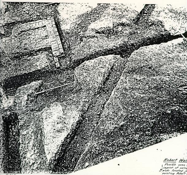 Robert Waller Property
Possible oven foundation and imprint of salvaged foundation walls located just east of existing Robert Waller House.
53-W-4599
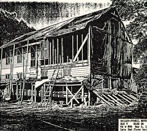 WALLER-POWELL HOUSE
BLK 7 BLDG 26
55 W 806 May 3, 1955
Late 2nd floor being removed.
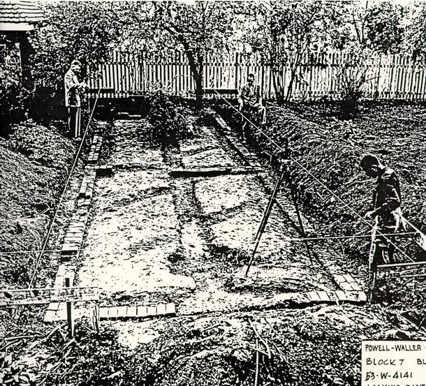 WALLER-POWELL QUARTER
BLK 7 BLDG 21
53-W-4141
Looking east
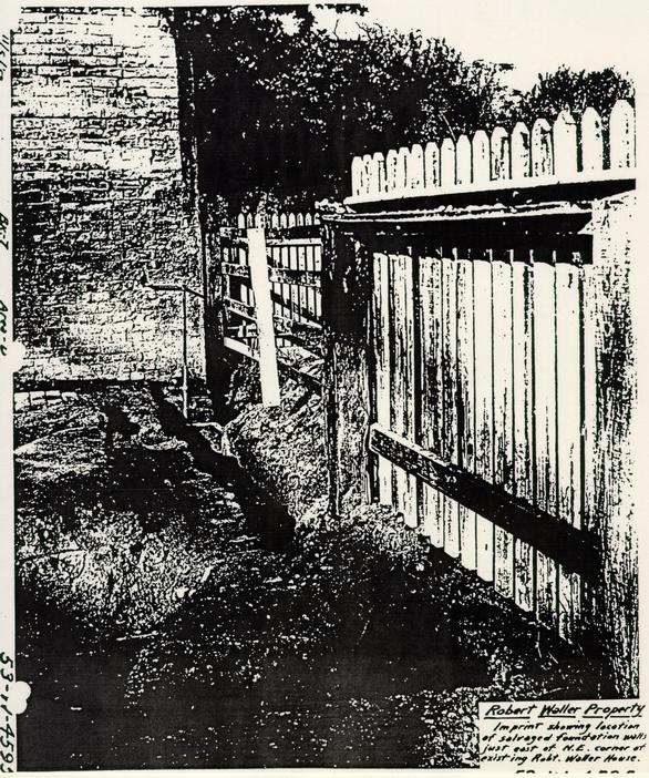 Robert Waller Property
Imprint showing location of salvaged foundation wall just east of N.E. corner of existing Robt. Waller House.
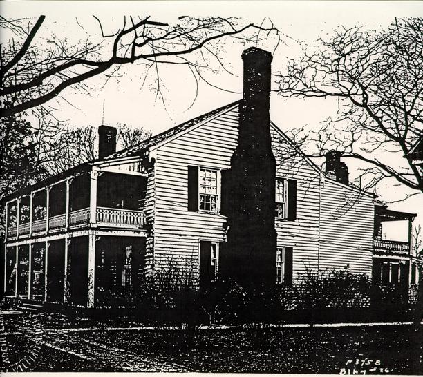 Figure 5
 Robert Waller Property
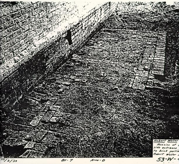
53-W-4066