Areas Adjacent to the Restored Area Architectural Report, Block 00 Originally entitled: "Preliminary Report on Areas Adjacent to the Restored Area"
Colonial Williamsburg Foundation Library Research Report Series - 1068
Colonial Williamsburg Foundation Library
Williamsburg, Virginia
1990
 [Map ]
[Frenchman's Map ]
Photostat copy of the Williamsburg Plat in "Williamsburg, the Old Colonial Capitol" by Lyon G. Tyler"
 Block 4
 Block 5
 Block 14
 Block 15
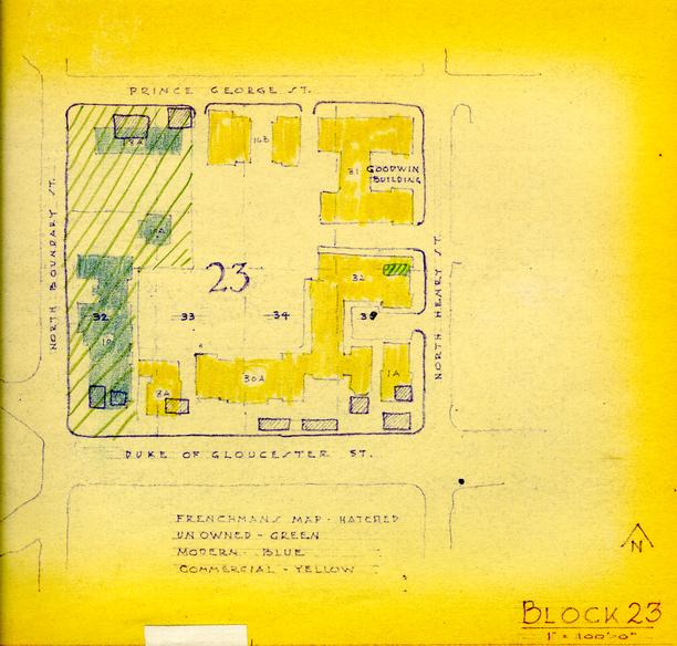 Block 23
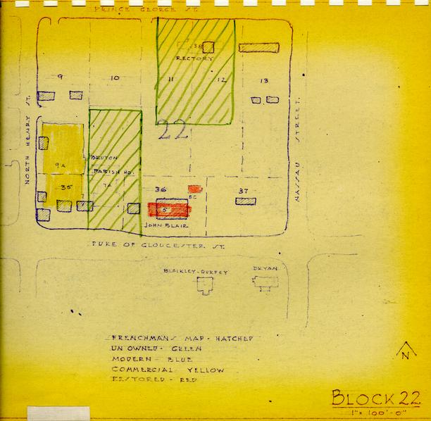 Block 22
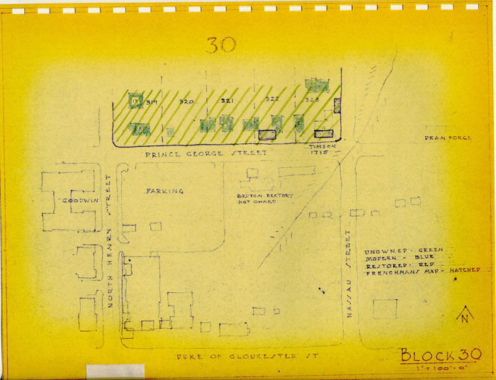 Block 30
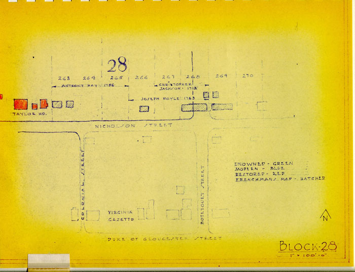 Block 28
From Frenchman's Map 1782?
 Block 27
From Frenchman's Map 1782?
PRELIMINARY REPORT
on
AREAS ADJACENT TO THE RESTORED AREA(This report is supplemental to the GRAPHIC REPORT ON 18TH CENTURY APPEARANCE OF THE BUSINESS BLOCKS dated Nov. 23, 1955)
Adjacent Area Report
The areas included have been designated on the following map by red cross hatching and the appropriate block number.
The boundary line of the Restoration area as it now stands is indicated on the following map.
The areas covered by the report are as follows:
- Block 4 - Eastern State Hospital Property
- Block 5 - Griffen House or Marshal Lodge
- Block 14 - Eastern State Hospital Administration
- Block 15 - C. W. Business Block
- Block 23 - C. W. Business Block
- Block 22 - C. W. Business portion of Block
- Block 30 - Private Residential
- Block 28 - C. W. area now outside "The Area"
- Block 27 - C. W. and Private Residential now outside "The Area"
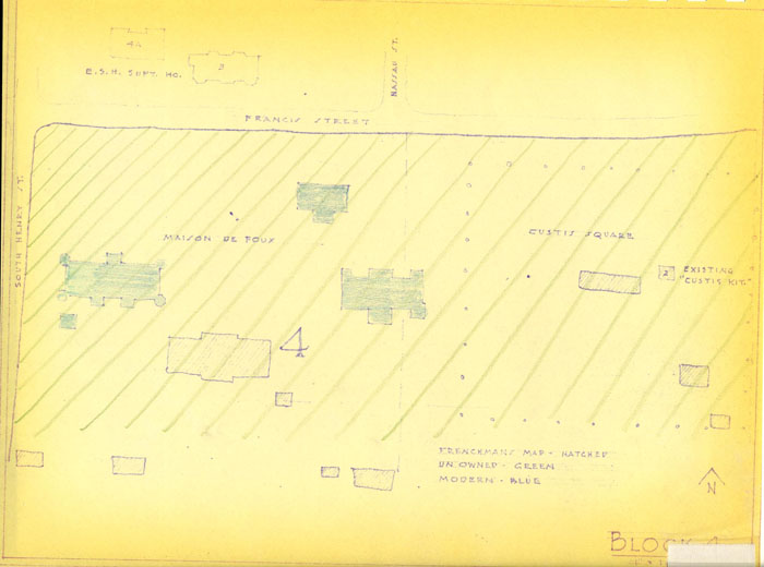
BLOCK 4
South side of Francis Street between South Henry and the Colonial National Parkway.
None of this property is owned by Colonial Williamsburg.
No archaeological investigation has been made.
"Custis Square"
Historical research has revealed that the lots were designated by 1718. John Custis had a fine garden and many records of his horticultural activities are available. The house was of brick and one of the outbuildings which is also of brick still stands. It was described in 1778 as having "two good rooms and a passage on the lower floor" and later as having four rooms and two passages.
The remainder of this block was and is still occupied by the Eastern State Hospital.
No archaeological investigations have been made and practically no historical research has been done.
It is probable that sufficient information can be unearthed to permit a reconstruction of the first Hospital for the insane.
BLOCK 4
This property now owned by the State of Virginia is occupied by the Eastern State Hospital for the Insane.
During the 18th century about half of the area was the property of the Custis family, Because of the great importance of this family in our national history an attempt should be made to reconstruct this early house and famous gardens.
The Hospital for the Insane was the first of its kind, and its importance both historically and architecturally cannot be over-emphasized.
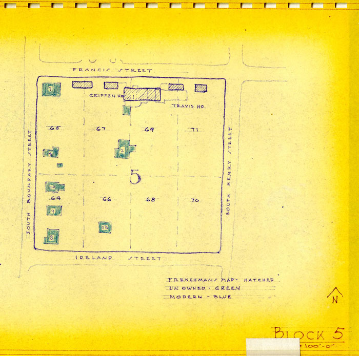
BLOCK 5
The south side of Francis Street between South Boundary and Henry Streets.
No archaeological investigations have been made.
Only the most rudimentary of historical research has been accomplished.
The 18th century house known as the Marshall lodge should be restored.
The Travis House is temporarily located on lot 71 and should eventually be replaced on its original foundation in Block 14.
BLOCK 5
The Griffin house is a handsome early structure and its restoration together with a reconstruction of the other 18th century houses along this side of Francis Street would provide a desirable completion of the restored area.
Work in this Block should not be undertaken unless it is planned to restore the several other Blocks at this the west end of Williamsburg.
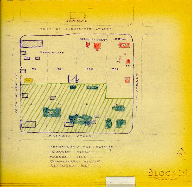
BLOCK 14
The portions of this Block now in other ownership should be acquired by Colonial Williamsburg and the reconstruction of the entire Block to its 18th century appearance would be desirable. This is particularly true if there is any possibility of restoring Block 4.
The Travis house now owned by Colonial Williamsburg may be returned to its original site on Lot "I".
The portion of the Block along Duke of Gloucester Street is not obtrusive now because no modern structures or incompatible uses have been introduced. A reconstruction of the buildings should be considered if it is contemplated to accomplish the reconstruction of Block 22.
BLOCK 14
The block bounded by the Duke of Gloucester Street and Francis Street, and between So. Henry and Nassau Streets.
The map indicates the ownership status of this block.
The northeast corner of this lot is in the restored area and the Bryan House and Blaikley-Durfee House and shops have been reconstructed.
The Frenchman's map shows a large building on Duke of Gloucester Street at the corner of South Henry with several outbuildings, another large house at the corner of South Henry and Francis and two smaller houses on the south half of the block.
Archaeological investigations have been made of the half of the lot facing on Duke of Gloucester Street. Relatively complete 18th century foundations were uncovered on lot 41 and on lot 42. The artifacts uncovered have not yet been processed or studied.
No excavation has been done on the half of the lot not in C. W. ownership.
Lots 41 and 42
Historical research while greatly handicapped by the loss of the James City County records which include this lot, present a quite clear if conjectural record of a large gambrel roof house on the lots in the mid 19th century. Further archaeological study may provide convincing evidence of the date of the houses.
The picture of these two lots in the 18th century is not crystal at this date but enough has been found to encourage further study. A number of pictures taken before the restoration are available; four are included in the Graphic Report on the Business Blocks of November 1955.
Lots on Francis Street
Mr. Charles recalled a two story frame building on the site of the building designated #3.
It is not possible to further clarify the development on these until such time as archaeological studies can be made. At that time additional Historical Research may also clarify the property ownerships.
The Travis House now temporarily located in Block 5 originally stood on Lot "I" corner Henry and Francis Streets.
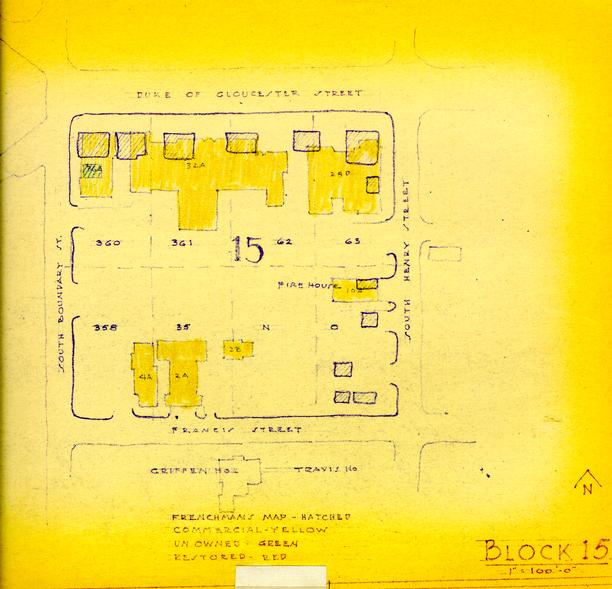
Block 15
The Block bounded by Duke of Gloucester Street and Francis Street, and between South Boundary and Henry Street.
The entire block is owned by C. W.
The Frenchman's map shows six buildings fronting on Duke of Gloucester Street and what may have been outbuildings along Henry Street.
No archaeological investigation has been made of this block. It is very possible that 18th century foundations may remain undisturbed under the present paving in front of the existing shops.
Historical research has revealed only the recollections of Mr. John S. Charles; he mentions only two buildings standing this block in 1862:
"...near the middle of the block there stood, up to about the beginning of this century, a very old house known to the writer as the 'Ware House.' This very old frame structure was a one-and-a-half story building with deep cellar and large shed on the back. It rested on a brick wall about four feet high, with a porch in front. ...This old structure, with dormer windows and a high porch, stood in the middle of a spacious yard in which were shade trees and a single story wooden building used as a kitchen. This yard is now the site of the Imperial Theatre and several other business places in a row. Immediately to the east of the present College Shop, was a small two story frame house which was removed a few years ago. This unpretentious old house was erected long before the Civil War, but it held its original appearance, with little or no repairs, longer than any house of similar construction within the writer's experience. Save for showing a lack of ... whitewash it presented practically the same appearance when pulled down a few years ago as it did when the great Union Army passed its door in 1862."Eleven old photographs of buildings in this block have come to light to date. See the Graphie report of the 18th century appearance of The Business Blocks dated November 23, 1955.
BLOCK 15
This Block, now entirely commercial is a distracting element in the otherwise almost perfect 18th century atmosphere of the Duke of Gloucester Street. If there is any possibility of the eventual restoration of the work outlined for Blocks 4, 5, and 14, this entire Block should be reconstructed. That part along Duke of Gloucester Street should be given careful study in any event.
While it is true that a reconstruction of the 18th century appearance of Block 15 would be largely conjectural, such work would be more authentic and hence of greater value than the existing development and land use.
BLOCK 23
North side of Duke of Gloucester Street from the Methodist Church to Henry street.
All of these lots are owned by C. W.
No archaeological excavations have been made but it is highly probable that significant remains still exist under the wide sidewalk area. It was a fortuitous circumstance which led us to set the commercial buildings well back from the colonial building line.
Historical research has not been exhaustive in this block, but the following information has been discovered to date:
Lot 32
"Middleton": In 1751 Sarah Packe, a widow, sold to David Middleton, a carpenter, lot 32 with the "house thereon" for £30. Until his death, ca. 1800, Middle owned the property - in 1753 Robert Carter Nicholas held a deed of trust on the lot, house, and Middleton's furniture in the amount of £67. Middleton's lot is mentioned in the York Records concerning adjoining property in 1800, when it was described as "a lot formerly the property of David Middleton, deceased."
Mr. Charles described the building on the lot where the new Methodist Church stands as being a small, two story framed house, owned by the heirs of a respected colored blacksmith.
A picture of the Duke of Gloucester Street from the college ca. 1875 shows a two-story frame house with small porch, on this corner site (see picture from the Century Company - ca. 1875.
Lot 33
"mead": Information on this lot is very sketchy. In 1719, trustees of the City deeded lot 33 to John Holloway. There is a long gap in the records concerning it - until 1800, when Caleb Spann and Priscilla his wife sold the lot to the east of "David Middleton, deceased" to Josiah Davis for $200.
Charles describes the next house to the east as being owned by Mrs. Lively, so he probably refers to lot 34. The Century Co. picture mentioned above, shows a house immediately adjoining the corner house.
Lot 34
There is no "Lively" in the York Co. Records.
Mr. Charles describes a house, at the time of his writing owned by Mr. Stringfellow, which "was built several years b fore the Civil War and was owned by a Mrs. Lively, both of whose sons were printers, and the older one was Editor of the Virginia Gazette, which was for several years after the war printed in the basement of this house, now used as a restaurant." This house stood to the east of the house on the Boundary Street corner.
Lot 39
"Abell" - The York Records have no information on lots belonging to "Abell." A Samuel Abell was living in Williamsburg in 1782 and is listed in the personal property tax records. Nothing is known as to his house.
Charles states that extending from the house described above (Mrs. Lively's -built shortly before the Civil War), was an eleven foot rail worm fence up to an old story and a half frame house at the Henry Street Corner. He described this corner house as having dormer windows, and being the residence of an old bachelor "who was an ardent devotee at the shrine of Bacchus." He said it was known as the 'Wise House' and bore every evidence of having been one of the original dwellings in Williamsburg. It was "pulled down by the Yanks and others."
Eight old photographs of this block are filed in the Graphic Report on the 18th Century Appearance of the Business Blocks dated November 23, 1955.
BLOCK 23
In the same manner and degree as in Block 15, the development and use of the Duke of Gloucester Street frontage of this Block is incompatible with the character of the Restored Area.
A recreation of the 18th century appearance of the Duke of Gloucester frontage. This Block is desirable if the other business blocks can also be done. The most difficult problem is that caused by the presence of the Methodist Church on the corner of Boundary Street.
As with Block 15 the reconstruction while highly conjectural would present a far more convincing picture than the existing buildings and land use.
BLOCK 22
North side of Duke of Gloucester Street from Henry to the James Blair House.
No archaeological investigation has been made of these lots. Fortunately because of the wide set back of the modern buildings, 18th century remains may still be uncovered.
Historical research has not been exhaustive on these lots but the following information has been found.
Lot 35 (owned in part by C. W. and in part by Bruton Parish Church) "Cocke" - In 1762, Charles Jones, tailor, sold to James Cocke for £260, lot No. 35 with all houses. The deed stated that the lot had been purchased by the said Jones from Henry Browne in 1756. James Cocke was mayor of Williamsburg in 1768, and died in 1789.
In 1930 a house known as the "Casey House" stood on this site. Mr. Charles described the Casey building as follows:
"...The three story building (now Casey's Grocery) was up to the latter part of the seventies only a two story frame dwelling fronting on Duke of Gloucester Street with an L on Henry Street, with a basement that was once used ... as a liquor shop. This house was called the "Rudd" property. Across the line between it and the "Hurt" lot there was ... a very old brick kitchen, one half of which was on each lot. This old kitchen was pulled down in 1866 and the bricks used in the construction of a small grocery store erected between the Casey residence and their present grocery store..."
A number of photographs of the buildings in this Block are in our files, the earliest being those in the Graphic Report on the 18th Century Appearance of the Business Blocks November 1955.
BLOCK 22
In the same manner and degree as in Block 15, the development and use of the Duke of Gloucester Street frontage of this Block is incompatible with the character of the Restored Area.
Recreation of the 18th century appearance of the Block, involves not only acquisition of property but a relocation of Bruton Parish Church Parish House. The most convenient possibility might be to move this important building to lot 13 in the same Block. A better location from the point of view of the Church, and not much worse from the point of view of C. W. might be the site of Judge Robt. Armistead's house on Prince George Street, which is now privately owned.
In the event the other Business Blocks are considered for reconstruction, at least the corner of Henry and Duke of Gloucester should be improved.
BLOCK 30
North side of Prince George between Henry & Nassau Street.
None of the area is owned by C. W. The Frenchman's map shows only two buildings in the area.
The house on the corner of Prince George and Nassau is the Timson House, probably dating from 1715 and as such is one of the earliest houses now standing in Williamsburg.
No archaeological work has been done.
Historical research has been done in outline only and that work was restricted to the Timson House.
Because this area is adjacent to the restoration area is so geographically prominent, and because this standing building is so early in date, it seems desirable to give further consideration to this Block.
BLOCK 30
While this entire Block along Prince George Street is included it is anticipated that only the Timson House on the corner of Prince George and Nassau should be restored. The remainder of the street should be in C. W. ownership to provide for uses not compatible with sites within the new Restoration Area.
BLOCK 28
North side of Nicholson Street between the Tayloe House and Botetourt Street.
Lots 263, 264 and 265 (owned by C. W.)
Archaeological excavations have uncovered several 18th century foundations. The artifacts recovered have not yet been processed or studied.
Historical research has revealed that Anthony Hay owned the lots in 1756 and that a dwelling house, cabinet shop, timber yard and necessary outbuildings were standing thereon.
Documentary evidence does not make clear just how many buildings stood on the site nor their uses although we have considerable evidence, through inventories, deeds and wills, of the people and their activities. It is possible that additional study of the archaeological remains will permit a sound reconstruction of the 18th century development of these lots.
Lots 266, 267, 268 (owned by C. W.)
Archaeological excavations have uncovered several 18th century foundations. The larger on lot 268 runs under Botetourt Street and was not completely excavated. The artifacts recovered have not yet been processed or studied.
Historical research has revealed that the property was occupied throughout the 18th century by well known people and a photograph taken in 1889 shows the jerkin gabled story and one half house which stood on lot 268 until the great fire of 1896. A reconstruction of this fine house would require closing Botetourt Street from Nicholson to Franklin Street and the provision of other access to the warehouse area. This could be done by reopening Raleigh Lane in Block 27.
BLOCK 28
The Restoration Area should be expanded in this and Block 27 to include the buildings fronting on Nicholson Street. This Street like Francis Street, must be reconstructed to complete the 18th century picture.
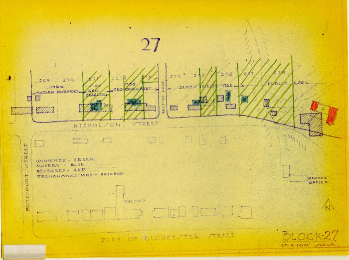
BLOCK 27
North side of Nicholson Street between Botetourt Street and the Gaol.
Ownership by Colonial Williamsburg is indicated on the map.
Lots 269 and 270 (owned by C. W.)
Archaeological excavations have been dug on colonial lots 269 and 270. The foundations uncovered are shown on a following drawing which also shows this portion of the Frenchman's Map drawn to the same scale. The artifacts recovered have not yet been processed and studied.
Historical research has revealed that a house stood on the site by 1739 inhabited by Joseph Davenport, the first town clerk of Williamsburg, and that it apparently remained in the family until 1800. Repairs by Humphrey Harwood indicate that the house had at least seven rooms, a passage and a stair. A picture of the house which stood on the lots to the west (Bowers House 1890) may provide some visual evidence of the appearance of the Davenport house. We have a copy of an inventory dated 1777 of the estate of Mathew Davenport which will be of value in reconstruction but unfortunately does not list the rooms.
Lot 271 (now owned by William Baker)
As indicated on the map of Block 27, the Frenchman's map shows a large structure on this lot. We have made no archaeological excavations but Mr. Knight, our field archaeologist has been in the basement of the modern Baker house. He reports that old foundations are to be seen.
Historical research reveals an increase in the valuations of the property in 1767 which may indicate that the house was enlarged to the size indicated by the Frenchman's map at this time. It was then in the ownership of Peachy Davenport. The recent former owner was George Charlton, a tailor.
The accounts of Humphrey Harwood covering repairs to the house in 1789 seem to indicate a building of at least six rooms and a passage. Little else has been learned to date concerning the 18th century appearance of this building.
Lots 272 and 273 (partly owned by C. W.)
No archaeological excavations have been made on the portions owned by C. W. because of the interest such excavation might encourage on the part of the adjacent private owners.
The Frenchman's map indicates a large house occupying portions of both lots and crossing the portion not owned by C. W.
Historical research reveals that a house stood on these lots from circa. 1719 until destroyed by fire in 1842. During the civil war period there may have been a small frame house on the lots as recalled by Mr. V. M. Lee. Mr. Charles does not recall any house at this time.
A mortgage on the lots written in 1744 lists "dwelling house Kitchen outhouses and Gardens." A deed in 1751 conveys a "newley created house" located on a part of lot 272. This latter may have been the 1-½ story house remembered by Mrs. Lee and known in the 20th century as the Patsy Custis House, moved to Francis Street and since destroyed.
Specific detailed information as to the appearance of these buildings has not yet been located.
Lots 274 and 275 (all of 274 and part of 275 owned by C. W.)
No archaeological excavations have been made on the portion of these lots owned by C. W. because of the interest such excavations might encourage on the part of the adjacent private owners.
The Frenchman's map indicates three small houses on these two lots. Historical research reveals that houses stood on each lot prior to 1761.
The building now misnamed "Redwood Ordinary" on lot 275 was certainly built well before the turn of the 19th century. The gambrel roofed house adjacent to the west but also on lot 275 was certainly built about 1826 by William T. Booker. The record and the memory of Mrs. Victoria Lee indicates that a one story house stood on Lot 274 at least until the civil war period.
The size of the houses and the records of their occupants do not indicate buildings of outstanding architectural character, but one (on lot 275) still stands and appears to be well worthy of restoration. The simple house which stood on lot 274 will pose no problem to accurate restoration if archaeological investigation reveals the expected foundations.
Lots X and Y (not owned by C. W.)
These lots which lie largely in a stream bed are adjacent to the Gaol property. Two small structures are indicated in this area on the Frenchman's map.
The Public Gaol is recorded to have been located on lot 278 and the Poor Debtors Prison on a part of lot 277. These lots were no doubt adjacent to lot 276 but we have not been able to determine the exact location of the boundaries.
Archaeological excavation has not been undertaken on this property because it is not owned. Pending such excavation nothing further can be deduced as to the structures on or 18th century development of this area.
BLOCK 27
The Restoration Area should be expanded in this and in Block 28 to include the buildings fronting on Nicholson Street. This Block of Nicholson Street is now on the route of many visitors and will become increasingly important as traffic is taken off of Duke of Gloucester Street.
Careful consideration should be given to the reconstruction of the house which stood across Botetourt Street. It was an important house and is essential to a recreation of the axial termination of the street, a feature of the City Plan of Williamsburg.