Timberlake-Dana Lots Archaeological Report, Block 2 Lot 255 Originally entitled: "Archaeological Report, Area J, Block 2 (Colonial Lot 255 - Timberlake-Dana Lots"
Colonial Williamsburg Foundation Library Research Report Series - 1057
Colonial Williamsburg Foundation Library
Williamsburg, Virginia
1990
ARCHAEOLOGICAL REPORT
AREA J, BLOCK 2
(Colonial Lot 255 - Timberlake - Dana Lots)
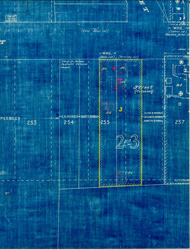
The Unknown Draftsman's map shows this area as being the eastern portion of Colonial Lot 255 and the western half of a street which was sold to James Semple. The Frenchmen's Map of 1782 shows two buildings located in this area. Fragmentary remains of two building foundations were found approximately in the same location as shown by the Frenchman on his map.
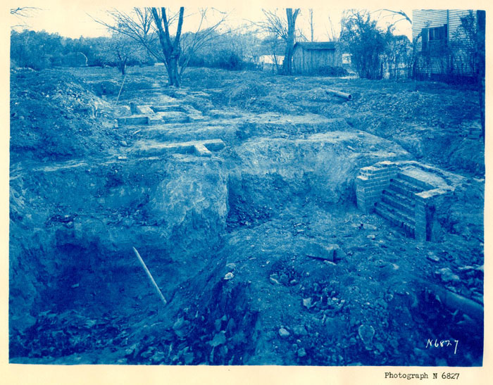
A- Foundation and Steps
(J-3 on Archaeological Key Map)
According to evidence uncovered, this appears to have originally been an 18" - 0" x 24' - 0" building with a 10' -0" x 12' - 0" basement.
Only the southeast and northeast corners of the foundation existed a-1) with a fill of brick fragments indicating where the east wall was. This foundation wall was approximately 9" thick and appeared to have been constructed of salvaged brick of various sizes.
Centering on the west end of the house site were the remains of brick basement steps (a-2) which went from the outside of the building to a 10' - 0" x 12' - 0" basement (a-3). The steps were also constructed of salvaged brick, similar to those used in the corners of the east wall. The basement was small in comparison with the building and was probably used for the storage of vege-tables in winter. There was no evidence that this basement ever had brick side walls, which is very typical of several other basements found in Williamsburg. No indication of a chimney foundation was discovered.
Evidence showed that this building was built on an early fill of well-packed hardpan and clay, apparently located at the head of the ravine which 2 originally crossed Duke of Gloucester just west of the Capitol.
The fill from this site contained mostly fragments of eighteenth-century china, broken ale bottles, rusty iron, shell mortar and brick bats.
| Brick size | 8½' to 9" x 41" to 4¼" x" to 2½" x 3" |
|---|---|
| Color | Dark red |
| Bond | English |
| Mortar | Shell |
| Condition | Poor |
See photographs N-6827 and N-6828.
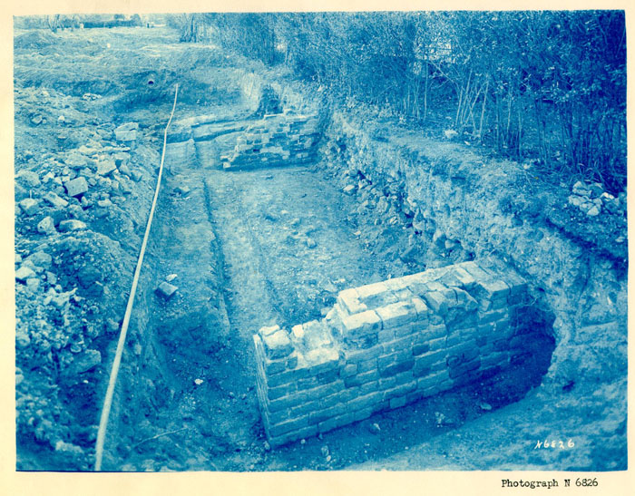
B - East End of Building
(J-4 on Archaeological Key Map)
Twenty-four feet west of the brick steps (a-2) were located the remains of what appeared to have been a dwelling. Only about 6' -0" of the eastern end of this building was uncovered and proved to be a building 25' - 11¾" in width. Its length was not determined because the property to the west is not owned by Colonial Williamsburg.
There was a crosswall running east and west, located fourteen feet from the front foundation wall. The front wall is back a distance of 9' - 6½" from the present south line of Francis Street and appeared to be the remains of what was a well-constructed foundation.
The debris which came from this area contained a few fragments of eighteenth-century china and pieces of broken ale bottles mixed with brick bats, shell mortar and black earth. Very little can be said regarding site, until further investigation, other than it is undoubtedly one of the buildings shown on the Frenchman's Map.
| Brick size | 8½" x 4¼" x 2½" |
|---|---|
| Color | Light and dark red |
| Bond | English |
| Mortar | Shell |
| Condition | Fair |
See photograph N-6826.
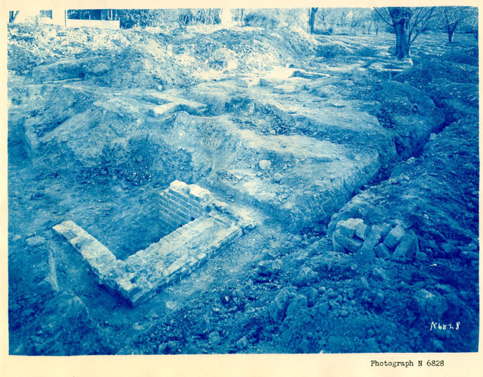
C - Forge or Shop
(J-2 on Archaeological Key Map)
These foundation walls appear to be among the earliest on this lot, since much of the foundation was destroyed when building A was constructed as well as a modern building recently demolished, it was not possible to determine anything in regard to the size or shape of this building. The remains of what was probably a forge (c-1) were located just south of what appears to be the foundation of a double fireplace (c-2). Eleven feet to the north was a "T"-shaped foundation (c-3) which was undoubtedly all that remains of the earliest building foundation in this immediate locality. This is also built on a fill of well-packed clay and hardpan used to fill in the head of a ravine.
Ten feet southeast of the forge was an eight foot section of a 9" wall (c-4) which was originally the southeast corner of the building. This wall lines up with the east end of foundation (c-2) indicating that the two walls may be related.
The well (c-5) is of modern construction. It was cleaned out to a depth of eight feet and no indication of early brickwork cam to light. It may be noted that most early wells had a such greater diameter than this one.
| Brick size | 8½" x 4" x 2½" |
|---|---|
| 8¾"x 4" x 2¾" | |
| Color | Buff and red |
| Bond | English |
| Mortar | Shell |
| Condition | Fair |
See photograph N-6827 and N-6828.
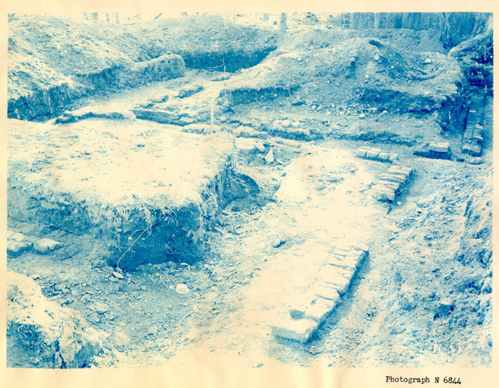
D - Outbuildings
(J-5 on Archaeological Key Map)
Two outbuilding foundations were uncovered in this location whose original use was not determined.
The 16' - 1¾" x 12' - ¼" foundation to the west (d-1) was the older of the two and lay under 18" of fill. According to the original grade in this immediate location, there is evidence that there may have been a slight depression or ravine, running to the north, when the building was constructed.
The later foundation (d-2) to the east was built of bats and salvaged brick with no indication of mortar being used. Its dimensions were 15' x 8" x 12' - 8" and of very poor construction. There is a possibility that the building which rested on the earlier foundation may have been moved to this site although there is a slight difference in the overall dimensions.
| Brick size | 8½" x 4" x 2-5/8" |
|---|---|
| Color | Red |
| Bond | English |
| Mortar | Shell |
| Condition | Fair |
See photograph N-6844.
E - Building Site
This area is located in the rear of the lot and occupies a square depression that is approximately 22' -9" x 22' - 9'. No foundation wall was found although a fill of crushed brick indicating what possibly was the location of the north and east wall of a building was uncovered.
The southern portion of the fill was approximately thirty inches below the present grade while the northern portion was only eighteen inches. (See archaeological drawing.)
5Most of the fill from this area was composed of black earth mixed with oyster shells and rusty pieces of iron such as are often found around barns and stables. Also some pieces of eighteenth-century china and ale bottles were scattered throughout the fill.
James M. Knight
Colonial Williamsburg
Architectural Department
March 20, 1942
 Photograph N 6826
 Photograph N 6827
 Photograph N 6828
 Photograph N 6844
 []
[]