Hubard Site Archaeological Report, Block 2 Lot 251-252Originally entitled: "The Hubard Site, Archaeological Report of Rescue Work Undertaken in 1968"
1968
Colonial Williamsburg Foundation Library Research Report Series - 1049
Colonial Williamsburg Foundation Library
Williamsburg, Virginia
1990
THE HUBBARD SITE:
Archaeological Report of Rescue Work Undertaken in 1968
October, 1968
Prepared by: R. Neil Frank, Jr.
Drawings and Photography by: Paulette Hancock
| Page | |
|---|---|
| Introduction | 1 |
| Precis of the Site's History | 1 |
| The Archaeological Evidence | 3 |
| Conclusions | 7 |
| Description of Illustrated Artifacts |
| Plate I - cooking pots from the cellar | 12 |
| Plate II - iron objects from the basement | 13 |
| Figure I - 1946 field drawing | 14 |
| Figure II - Hubard House structural remains | 15 |
| Figure III - 1968 architectural finds | 16 |
| Figure IV - Frenchman's Map | 17 |
THE HUBARD SITE: ARCHAEOLOGICAL REPORT OF WORK
UNDERTAKEN IN 1968
The removal of the modern Foster's Gift Shop from Lot 251 involved this department in minor archaeological rescue work during the period March 20-28, 1968. Only those areas exposed by the moving contractor were examined and in consequence only small portions of features could be studied. The 1941 excavations on the adjacent westerly property (Lot 250?) uncovered the remains of a substantial structure whose east/west walls continued toward Lot 251.1 Later, in 1946, during the construction of the Gift Shop, additional evidence of the property line-straddling building was encountered on Lot 25l (Figure 1) and these are the features that were reexamined in 1968. The following report describes the information gleaned from that brief study. However, it must be understood that conclusions arrived at in such haste and with so little ground studied may later be subject to modification and even rejection.
Precis of the Site's History2
Unfortunately, since the court records of the James City County part of Williamsburg were destroyed during the Civil War, the early history of Lot 251 cannot now be 2 ascertained. The earliest known holder of the property was Philip Grymes, who sold the land to James Hubard in 1774. The deed recording the transaction, found among some loose papers in the Fredricksburg District Court, stated that Hubard had purchased:
"all that Messuage or Brick dwelling House situate on the South side of Francis Street in the City of Williamsburg, also three Lots of land on which or one of them the said dwelling House standeth and which said Lots of Land are discribed in the plan of the said City by the figures 252. 801. and 253."3Obviously, there is some confusion regarding the identification of the lots mentioned in the deed; however, the Tyler Map of 1791(?) indicates that Hubard occupied Lots 251 and 252 on Francis Street.
Nevertheless, there is no doubt that the building found in 1941 and the portion examined in 1968 was the house wherein James Hubard's widow, Francis, lived between c.1782 and 1797 when the structure was destroyed by fire. At least three extant documents mention the disaster, the earliest being a newspaper notice, dated April 5, 1797, which stated that the fire occurred "yesterday between 4 and 5 o'clock in the afternoon."4
Since the bulk of the features and artifacts examined in 1946 and 1968 were associated with the structure destroyed 3 in 1797, it is unnecessary to pursue the site's history further. For additional data concerning the, property, one should consult Miss Stephenson's research report (see note 2).
The Archaeological Evidence
Before discussing the features and artifacts studied in 1968, the circumstances that prompted the minor rescue archaeology should be mentioned. The removal of the modern gift shop to a new location necessitated digging numerous trenches so that crossbeams could be placed beneath the structure. Fortunately, only two of the lots (those running north/south) cut through eighteenth century strata. In addition to the trenches, four deep 4' x 4' jack holes were dug near the modern shop's interior corners.
Three of the jack pits disturbed no features or strata of any importance; however, that at the southwest cut into the rubble-filled basement of the burned Hubard house. The artifacts recovered from the fill (E.R. 968 A) included three bars from basement window grills, a 3'0" long handle for a skillet or warming pan, a trunk handle, a strap hinge which had been affixed to a board ¾" wide (this fact discernible because clinched nails were still attached to the hinge), and an H-hinge (Plate II). The deposit also contained two iron cooking pots (Plate I), one of them intact and measuring 1'7½" in diameter and 1'6" in height. This 4 is the largest complete iron pot yet recovered from Williamsburg excavations. The other cooking pot was l'0" in diameter and 9½" in height.
Beneath the brick rubble fill and covering a mutilated brick floor was a stratum of mixed gray and black ashes (E.R. 968 B) containing fair quality creamware, late white saltglaze stoneware, and sherds of coarse earthenwares ranging from ordinary kitchen vessels to a large Iberian storage jar. The since restored remains of another such jar were found somewhere on archaeological area 202 (Chiswell); however, since no report exists of that excavation, it could not be determined if those fragments came from the Hubard basement.
There was no indication of any surviving foundation against the north face of the cellar hole, but the rubble was not entirely extracted along that line. However, it is possible that the building's north wall was totally robbed, since the map of the 1941 excavations (Figure II) shows only traces of it along the structure's western half. The 1774 deed referred to the house as being of brick, and the vast quantity of brickbats filling the cellar provided archaeological proof of it. Two rubbed quarter-round bricks recovered from the debris would seem to suggest that the building had an offset water table. Some of the window glass fragments found in the basement appeared to have been of early eighteenth century date. It was conjectured, in 1941, that the 5 structure may have been an early one because of "its location with respect to the colonial lot line and the building line, by patches of melted lead which may have been used in window cames,* and perhaps by the absence of verifiable historical information which might identify it"5 -- though the reasoning behind the last factor is now somewhat obscure. The same source was elsewhere somewhat contradictory when it stated that the remains of the house indicated that it "was 'in the best style of the period' (mid-18th century) since fragments of dressed stone, marble, rubbed and gauged brick were found in the filling of the brick paved basement."6 It went on to state that "the basement floor was paved with ordinary brick and with square brick tiles, a number of which are still in place."7 The building was found to be "23' wide and 33' long to the property line.8 By probing westward from the southeast jack hole in 1968, it was determined that the structure had a total length of approximately 65'0".
When Foster's Gift Shop was constructed (1946) a portion of the colonial cellar's fill was revealed near the Southwest corner of 6 the new building (Figure I). On July 12, 1946, Mr. James M, Knight reported that
"the ancient foundation wall could not be seen on account of the antique shop foundation walls having been poured with concrete the day before. According to Mr. Walter Bozarth, the contractor on the job, the new concrete foundation walls are not deep enough to damage the ancient foundations to any extent."9The 1968 reexamination of that area proved that Mr. Bozarth's analysis was correct, for although the modern concrete footing bonded to the colonial brickwork, no damage to the latter was detected.
A southerly extension of digging, from the southwest jack hole, uncovered the "ancient foundation wall" referred to by Kr. Knight. This feature proved to be part of an east interior chimney (Figure III) whose back was 1'6" in thickness.10 The total size and shape of the chimney was not determined since the digging did not go far enough in a southerly direction; however, the chimney's 1'l" northeast cheek and its unearthed back portion were plotted for future reference.
The rough plan drawn by Mr. Knight in 1946 (Figure I) showed a small piece of wall passing beneath the southeast corner of the modern shop's east/west block. This 9" foundation again was exposed in 1969 and was found to have but two 7 surviving courses. It seems likely that this was the structure which is shown northeast of the Hubard house on the Frenchman's Map (page 17); however, dating evidence to substantiate such a conjecture was not found. No doubt future excavations of the property will be able to reveal far more about the small building than was possible by studying the brickwork in section in 1968.
Conclusions
There is little doubt that the structure found in 1941 and examined in 1946 and 1968 was the building occupied by Mrs. Hubard until the fire of 1797. The house, fronting on Francis Street, was 23'0" wide and had a conjectured length of 65'0". It was built of brick, probably with an offset water table, and was almost certainly more than one story high since, according to the report on the 1941 excavations, the structure's walls were "more than 21" thick."11 A portion of the building's east interior fireplace was located, but additional digging is required to determine the chimney's total size and shape.
Another structure, with 9" brick foundations (Figure I), was partially uncovered in 1946 and re-studied in 1968; however, the building's size or utilization could not be determined. 8 It would seen likely that this was the small structure fronting onto Francis Street which is shown northeast of the Hubard House on the Frenchman's Map.
The 1946 construction of the Foster Shop and its subsequent removal in 1968 apparently disturbed only a small portion of the Hubard House's remains. The recovery of so many important artifacts during the limited 1968 archaeological work would suggest that a proper excavation of Lot 251 could be most rewarding.
R. N. F.
DESCRIPTION OF ILLUSTRATED ARTIFACTS
The Hubard house cellar was filled with the debris of the ruins dismantled after the fire of April 4, 1797 - thus providing a terminus ante quem for the following artifacts:
Plate I
(top)
Cast iron cooking pot (largest intact one yet uncovered in Williamsburg) with an average exterior diameter of 1'7½" and a height of 1'6"; the two handles are round-sectioned (7/8" diameter) and elbow shaped; the body had been decorated with three exterior cordons -- two near the base of the handles and the other some 2" above the top of the legs; one of the three legs was broken during treatment, but was restored; however, to support the weight of the pot in that section, a metal bar was attached to the underside of the body (see left background); the other two legs remain intact and measure 4¼" in length while the width varies from 1¾" at the top to 1" at the base. (4037-N.R. 968A-2P.)
(bottom)
Cast iron cooking pot with an exterior diameter of 1'0" and a height of 9½", the two handles are round-sectioned (½" diameter) and elbow shaped; the body had been decorated with three exterior cordons -- two near the base of the handles and the other some 1½" above the top of the legs; only two of the legs survived, and those appear to have never been long enough to elevate the pot above the floor; consequently, it was conjectured that they merely balanced the utensil rather than supported it; the intact legs are 1 5/8" long. (4038-E.R. 968A.-2P)
Plate II
- 1. Grubbing hoe, iron, socket slightly tapered and extending into a raised triangular spine on the blade. (4032-E.R. 960B-2P)
- 2. Trunk handle, iron perpendicular ear terminals, attached cotter pin had been clinched after passing through a piece of wood. (4031-E.R. 968A-2P)
- 3. Skillet handle, iron, shank was broken by the moving contractor's men but the handle totaled 3'0" in length, had an average thickness of ¼", and the shank's width tapered from 1½" to 9/16". (4030-E.R. 968A-2P)
- 4. Bolt for a plate stock lock, iron, head missing. (4033-E.R. 969A-2P)
- 5. Lock bolt, as above except its head was intact. (4034-E.R. 968A-2P)
- 6. H-hinge, iron, each side having four countersunk screw holes. (4029-E.R. 968A-2P)
- 7. Ornamental H-hinge probably from a cupboard, iron, with trefoil terminals, five nails attached. (4035-E.R. 969A-2P)
- 8. T-shaped hinge, iron, crossmember had four nail holes spaced approximately 1 5/8" apart and three of the nails were attached, tapered shaft had five nail holes with two of the clinched nails attached, the latter indicating the hinge had been used on a piece of wood ¾" thick. (4028-E.R. 968A-2P)
- 11
- 9. Reused bar from a window grill, iron, terminals had been flattened to a thickness of ¼" and had three nail holes drilled into them, total length originally was 2'2" but the bars had been chiseled and broken in half for use in a smaller basement window, the hammering of the chisel caused each bar-half to be slightly beveled on each side, traces of mortar on the beveled end indicated that the shortened bars had been anchored at one end by mortar and, since the terminal had been retained, the other end had been attached to a sill by three nails. (4036-E.R. 968A-2P)
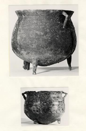 Plate I - The two cooking pots recovered from the filling of the Hubard House basement. The smaller one measured 1'0" in diameter and 9½" in height while the other one was 1'7½" in diameter and 1'6" in height. 68-PH-2241.
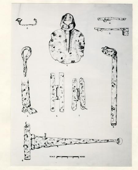 Plate II - Iron objects found in the Hubard House basement. For descriptions see page 10.
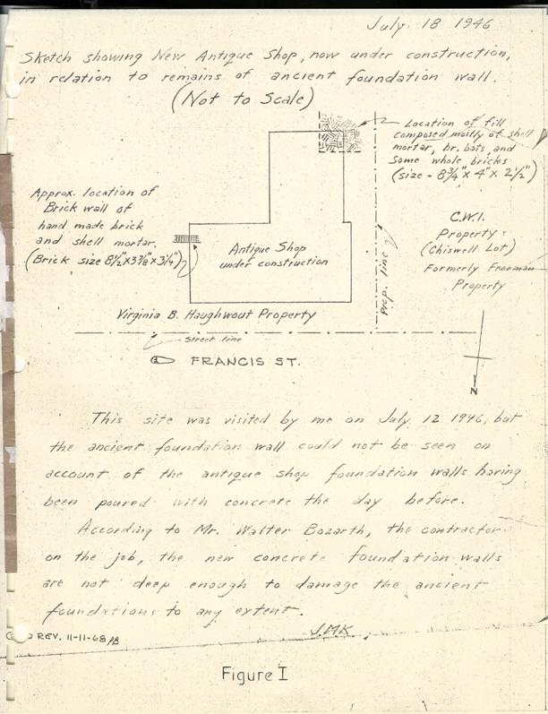 FIGURE I - Handwritten Note and Sketched Map of Haughwout Property
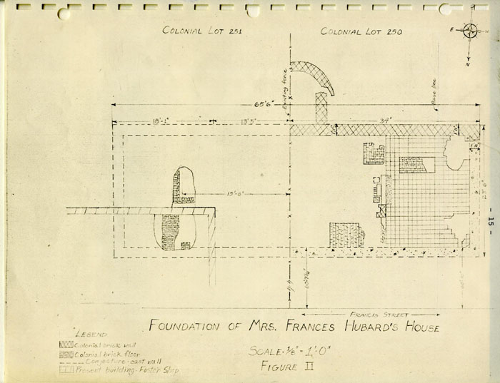 Figure II - Plan of Foundations
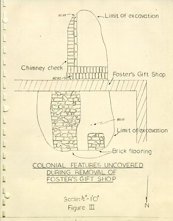 Figure III - Plot of Excavation
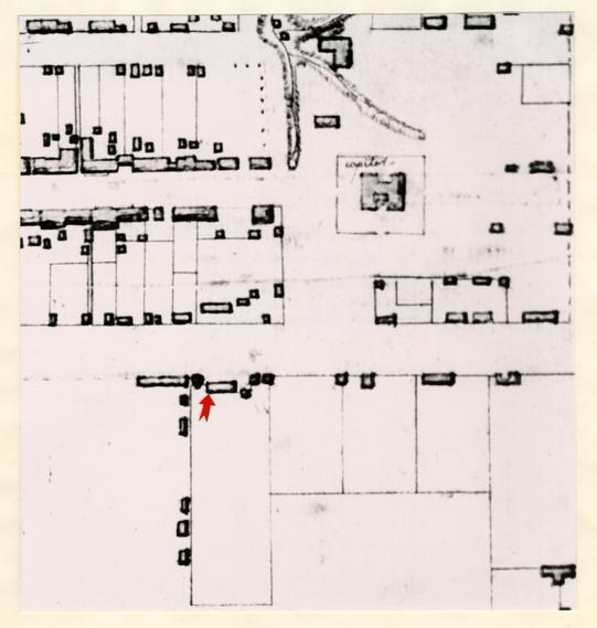 Figure IV - Detail from the Frenchman's Map with arrow pointing to structure partially examined in 1968.