George Carter Lots Archaeological Report, Block 2 Lot 247Originally entitled: "Archaeological Report: Lots East of the "Graves" Lot, Block 2, Areas F & G"
Colonial Williamsburg Foundation Library Research Report Series - 1046
Colonial Williamsburg Foundation Library
Williamsburg, Virginia
1990
Archaeological Report
LOTS EAST OF THE "GRAVES" LOT
BLOCK 2, AREAS F AND G
August, 1941
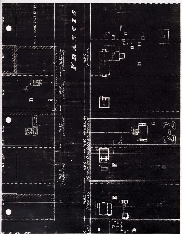
Excavation in 1940 of Archaeological areas F and G in Block 2 revealed two early foundations.
No information whatever is available regarding the history of these particular areas in Colonial times. (See Research Report: Lots East of the "Graves" Lot: 9.13.40) It is probable that the foundation of Area G represents a house built before 1699, the year when the street and building lines were established - for this foundation is neither near nor parallel to these lines. The brickwork and plan of the foundation could be attributed to an early period, as will be pointed out in greater detail.
The foundation of Area F is on the building line and, therefore, is probably of a date after 1699.
Both foundations stand partially on the right of way of the "Dedicated Street" which was ceded to public ownership at the time when the south end of Queen Street and the east end of Ireland Street were closed to provide access to property to the south not owned by the Restoration. Up to the present this street has remained unimproved except for the opening up of drainage ditches.
Area F (Photographs 6482-3)
The area comprises the Mt. Ararat lot, a narrow slice of the Graves lot on the west, and about 15 feet of the Epps lot on the east. More than 20 feet of Area F, on the east, falls within the right of way of the Dedicated Street.
A brick foundation was uncovered on the Colonial building line, 20 feet back from the street line. Its east end was 12 feet over the line of the Dedicated Street.
2The east portion of the foundation, about 22 feet wide and 24 feet long, was almost intact. The slight depth of the footing (only 1-½ feet below grade) indicates that there was no basement. The thickness of the brickwork (about 19 inches) indicates that the walls above may have been of brick, one story high. Centered on the cross wall is the foundation of a very large inside chimney, the fireplace of which measured 4 x 8 feet. Joints where the walls join the chimney indicate that the latter was built as a unit, at a different time possibly than the walls.
| Brick | Size - 9 ½" x 4 5/8" x 2 ½" |
|---|---|
| Color - Red and buff | |
| Mortar | Oyster shell |
| Bond | English bond with some bats |
| Condition | Fair |
A western division of the foundation is indicated by portions of the north and south wall, and by chimney breasts matching those already described, but facing west.
The north wall is 14 inches thick, the south wall is 10 inches, and set back 4 inches at the corner. This wall might have been 14 inches or more thick. Only one course remains, and that for a short distance, and the 4 inches or more of thickness may have disappeared.
Both walls butt against the east portion, an indication that they were built later.
The western part of the chimney is bonded in with the eastern, indicating that the chimney was built all at one time. The entire chimney, however, seems to have been built as a unit independently of the abutting walls, which are separated from it by butt joints. It seems possible, 3 therefore, that if the original eastern part of the building had a chimney, that chimney may have been rebuilt from the ground up at the time of the addition, or, that all were built at the same time, but the outer walls were not bonded.
| Brick | Size - 9 ½" X 4-5/8" x 2 ½" |
|---|---|
| Color - Light red | |
| Mortar | Oyster shell |
| Bond | English |
| Condition | Fair |
A foundation 14 inches thick is indicative of a frame rather than a brick structure. It seems likely that this building was of brick on the east end and of frame on the west. There is no direct evidence how far it extended to the west. Possible indirect evidence is furnished by a rectangular fill, once a pit about 7 x 15 feet in extent and 4-½ feet deep. If this pit was outside the west room, the room could not have had a clear width of more than 12 feet, yet a room with a fireplace 8 feet wide is virtually certain to have been of ampler dimensions. (The east room had a clear width of 16 feet.) Assuming that the pit was contained within the room, the clear width must have been 20 feet or more, a much more likely supposition. It seems possible that this pit may have served (in the absence of a basement) as storage space for potatoes, etc., reached perhaps through a trap door.
Area G (Photographs 6489-90-91-92) Possible 17th Century Building
This foundation lies roughly 100 feet back from the street line. The 14 inch walls seem to indicate a frame building. There was no basement. The exterior measurements are 22-½ x 32-½ feet. Outside chimneys at 4 each end were flanked by closets, at northeast, northwest and southwest. No evidences of a fourth closet remain at the southeast corner, but here the foundation may possibly have disappeared. The foundations of these closets meet the house with butt joints, evidence that they may have been built later.
| Brick | Size - 9 ½" x 4 ½" x 2 ½" |
|---|---|
| Color - Salmon or buff and red | |
| Mortar | Oyster shell |
| Bond | English |
| Condition | Fair |
G-2
A small outside basement foundation 12-½ feet square and 5 feet deep below grade projects northward from near the center of the building. The walls are about 14 inches thick, but irregular on the outside where they seem to have been built directly against the earth bank. The east wall is noticeably off perpendicular with reference to the main building. The floor is brick-paved. At its center is a hole over 2 feet in diameter and two feet deep. Such a hole must have served as a sump to take care of water from melted ice or seepage. This may have been a dairy, but no reason is evident why it should have stood in this conspicuous location. It might have formed a basement under a porch or entrance chamber, but it seems strange that a dairy should have been located here if this was the entrance front. It is possible that the house when built faced south, for it is clearly not planned in relation to present street lines and indeed it seems likely for that reason that the house was built before the street was laid out. The dairy foundation seems, if anything, earlier than the main foundation, for the latter is built largely over the former. Probably the 5 building, if originally a dairy, was torn down or converted into a storage basement when the house was erected.
| Brick | Size - 9 ½" x 4" x 2 ½" |
|---|---|
| Color - Red and buff | |
| Mortar | Oyster shell |
| Bond | English |
| Condition | Fair |
No outbuilding foundations were encountered in the whole of Areas F and G. The one well is of modern character (though the shaft may be older). It is possible that outbuildings with shallow foundations once stood here, but that plowing or salvage operations destroyed the traces. This, however, seems unlikely in view of two facts: (1) more or less complete groups of outbuilding foundations have survived to eastward, on the Chiswell site, and to westward on the Ewing site; and (2) the two foundations of F and G, while not unusually deep, are not in an unusually bad state of preservation. It, therefore, seems likely that if any other foundations had existed in this area, evidence of them would have been found.
Foundation G is not exactly parallel to Francis Streets but lies as if rotated clockwise about 4- ½ degrees, the axis running exactly north and south. Its center line projected towards Francis Street intersects the building line at a point halfway (within a few inches) between Foundation F and Foundation H-4 (See Archaeological Report: Chiswell Site: August, 1941).
The earlier or eastern portion of Foundation F is strikingly similar to Foundation H-4 (except that the former has no basement). Both have walls about 19 inches thick, and both are 24 feet long on the street front. (H-4, however is 24 feet wide and, therefore, square, while the 6 width of F is 22 feet.) The chimney of F was probably rebuilt at the time the west addition was made. Whether the later foundation followed the lines of the earlier, or not, the chimney might have presented the same appearance above the roof as the chimney of H-4.
So close a resemblance between the two buildings, taken together with their symmetrical location about the axis of G, creates a strong presumption that F and H-4 were built as twin dependent buildings to flank the approach to G. (For further discussion of H-4 see Archaeological Report: Chiswell Site: August, 1941). It is possible that H-4, as conjectured in that report, was used or even built as a store, but it still might have been so designed and located as to balance F.
Brick characteristics of H-4 are given here for comparison with those of F:
| Brick | Size - 9" x 4- ¼" x 2 ½" |
|---|---|
| Mortar | Shell |
| Condition | Fair |
The Frenchman's map is of little value as evidence in this connection, since (1) it is not possible to state which, if any, of the three buildings (F, G, H-4) were standing at the time of the map, and (2) the evidence of the map in this area seems more than usually open to doubt (For further discussion, see Chiswell Archaeological Report.) One possibility is that a long structure shown on the map was Benjamin Bucktrout's wood shop and lumber shed (a type of building which might have disappeared later without leaving any evidence), while a square structure shown just east of it might have been H-4. This would imply that F and G had disappeared or were ignored.
A considerable distance is shown on the map between the long structure and the next building to the west - so considerable that it might have included the sites of F and G.
Of no greater value in this connection than the Frenchman's map are the real estate maps (Bucktrout's, etc.) of about 1800, for there is no evidence that any of the three buildings in question was still standing at that time.
The most likely theory seems to be that G was built before 1699, and F and H-4 at some later date. H-4 may have been built for use as a store; if not, it was probably converted later to this use (see Chiswell Report). The latter case seems the more probable in view of the lack of evidence of smaller outbuildings around or behind G; for if there were no other outbuildings there would have been sufficient need for both F and H-4, as kitchen, laundry, etc.
Sources
Report of Department of Research and Record: Lots East of Graves Lot: 9.13.40. Photographs: N6482-3, N6489-92 inclusive. Fragments:In the fills of the east portion of foundation F, and of G-2, were found a considerable number of fragments. Many appeared to be clearly of XVIII century origin. These have been consigned to the Department of Education for custody and study. Archaeological Drawings: Block 2, Area F, Area G
F. D.
 [Oversized Blueprint]
[Oversized Blueprint]