Chiswell-Bucktrout House Archaeological Report, Block 2 Building 17 Lot 253-254Originally entitled: "Archaeological Report:
Chiswell-Bucktrout House, Block 2, Building 27 (Archaeological Area H)"
Colonial Williamsburg Foundation Library Research Report Series - 1020
Colonial Williamsburg Foundation Library
Williamsburg, Virginia
1990
Archaeological Report
CHISWELL-BUCKTROUT HOUSE
Block 2, Building 17
(Archaeological Area H)
July 30, 1941
| Chronological Table Page No. | 2 |
| General Description | 3 |
| Architectural Report on Existing Building, by John W. Henderson | 8 |
| Detailed Description | 22 |
| List of Sources | 39 |
| Notes | 40 |
| Letter from Mr. Goodwin, 7-2-41 | 47 |
| Excerpts from Conversation of J. W. Henderson with Mrs. Haughwout | 48 |
| Tracing of Cypher on Ancient Wallpost | 49 |
| Enlarged Diagram of Area H in Frenchman's Map, Buildings Lettered | |
| Section of Archaeological Key Map | |
| Archaeological Drawing |
CHRONOLOGICAL TABLE
Based on Report of Department of Research and Record February 12, 1941
| 1699 | Street, building and possibly lot lines established on Francis Street. |
| 1752 | John Chiswell first in Williamsburg. |
| October 15, 1766 | Chiswell's death. His son-in-law, John Robinson, died the same year. |
| June 16, 1768 | "To be sold ... next door to Mrs. Chiswell's, a neat assortment of cutlery ..." (Peter Pelham) (Virginia Gazette) This same seems to have been forced by the debts which Robinson had left. |
| April 30, 1770 | Notice of sale of the property. Benjamin Bucktrout may have been the purchaser. He advertised:October 20, 1774 February 3, 1775 (It is not certain, however, that the preceding two advertisements refer to Area H.) |
| August 28, 1779 | On or soon after this date Bucktrout sells or leases "houses and lots where the subscriber lives, formerly belonging to Col. Chiswell." |
| October 2, 1779 | William Davenport announces his occupancy of the property and opening of a tavern. |
| c. 1800 | Bucktrout and unknown draftsman plats show 3 lots belonging to Chiswell. Could the Chiswell family have retained title as long as this? There is no evidence that a sale was ever concluded to either Benjamin Bucktrout (1770) or W. Davenport (1779). |
| From | To | |
|---|---|---|
| Rev. John Bracken | Before 1815 | 1818 |
| Bracken Estate | 1818 | 1840 |
| Lemuel Bowden | 1840 | 1867 |
| Bowden Estate | 1867 | 1873 |
| Morecock | 1873 | 1883 |
| Porter | 1883 | 1890 |
| Slater | 1890 | 1895 |
| Wise | 1895 | 1922 |
| Freeman | 1922 | 1928 |
CHISWELL-BUCKTROUT HOUSE
GENERAL DESCRIPTION
This area is situated on the south side of Francis Street towards its east end, and is coextensive with the Freeman lot of modern times. This lot covers the Chiswell tract as shown on the early plats1, with the addition of narrow strips on the east and west sides and some changes in the rear portion2.
The present building on this tract (the "Freeman House") was known to be in part colonial. It was dismantled early in 1941, and its ancient frame was uncovered. This frame showed evidences of having been moved to the site from elsewhere and repeatedly altered and enlarged.
Archaeological excavation in Area H was commenced near the end of 1940. The area was cross-trenched over the entire north portion and shaved off in certain sections. Exploratory trenching is now being carried on over the large rear area wherever possibilities of findings are indicated. All traces of construction have been laid bare, and loose fragments have been saved and classified according to the location where found.
The present dwelling (H-5 on the Archaeological key map) stands about 12' back from the building line, a line which was established in 1699. But another foundation was discovered, that of an earlier dwelling (H-3) which had stood exactly on the building line, half within and half in front of the area now occupied by H-5.
In the northwest corner of Area H, also on the building line, is a foundation 24' square which seems to be that of a shop (H-4).
Immediately east of the building is the first of a series of outbuilding foundations (H-2, H-6, H-7, H-8, H-9, H-10, H-11) which extends for some distance to the south.
On the eastern boundary of the property, set back some 40' from the building line, is a basement fill where stood an early brick building (H-1).
While the early plats seem to cause no difficulties in interpreting the 4 evidence of this site, the same is not true of the Frenchman's Map, which seems to be at odds in one respect or another with any possible interpretation of the evidence.
The Frenchman's map shows in what corresponds to the north portion of Area H, two shaded rectangles which might represent two dwellings. Of these, the one to the west (map, E)3 is on the building line, and is a very long structure divided by a line at the center.
The second building (map,C) is shown farther east. It is of medium size, and is set back a short distance from the building line.
Uncertainties or contradictions appear to be involved in any attempt to identify C or E of the map with any one of the known foundations. But three hypotheses in particular have received consideration:
- 1
According to the FIRST, the long structure on the building line (map, E), or more specifically its eastern segment (E-1), is the early dwelling, H-3 of the archaeological drawing4.
The great length of this building on the map would be explained by the assumption that it was extended in some fashion (as by a shed, fence, or covered passage) to connect with the shop H-45.
On this hypothesis, the kitchen, H-2, and the outbuildings south of it are mapped in their true locations. Dwelling C of the map would coincide with foundation H-1, which is in fact - like H-1 - set back from the building line.
Pending possible future excavation (because we do not own the property to the east), it is impossible to say whether any foundations exist which might correspond to the three outhouses shown east of C (map, A-1, A-2, and B).
The following objections to this hypothesis may be raised:
- AIf C represents H-1, it is inaccurately located, being shown about 40' closer to D than the foundations show that H-1 was in fact to H-2.
- BThe map shows a fence line with the northernmost outbuilding east of it, and five others west. But no one line can be drawn which will 5 divide the foundations excavated in this manner.
- CIn H-5 (the existing dwelling) there is strong evidence of early construction - not only in the wood frame (which is known to have been brought from elsewhere), but also in the masonry, particularly the chimney. But if H-5 is in fact an early structure, then H-3 cannot have been standing on an overlapping site at the time of the Frenchman's map (c. 1786).
- 2
According to the SECOND hypothesis, E-1 and E-2 of the map represent existing dwelling H-5. C of the map would then represent H-1, as in the first hypothesis. But it must now be assumed that shop H-4 had disappeared or was ignored at the time of the map.6,7
Kitchen D, and outbuildings F, G, H. J and K, would then have approximately their true location in relation to the dwelling. The early character of the chimney of H-5 would be understandable.
But objections A and B to the first hypothesis would still stand. And no reason is apparent why a structure which is in fact set back from the building line should be mapped exactly on the line.
- 3According to the THIRD hypothesis, C of the map represents H-5. D would then represent H-4. It must be assumed that H-1 had disappeared (or was ignored), and that the long building to the west (E) was a line of sheds or woodworking shops, or some such light structure which has since disappeared without leaving a trace. The same might be true of two of the outbuildings shown to the east (A-1 and A-2).8
A more serious difficulty is that the major line of outbuildings (F, G, H. J and K of the map) is shown westward of C, whereas in fact they lie eastward of the dwelling H-59. But there is no interpretation of the Frenchman's map in this area which must not assume some inaccuracy in the map.
Discrepancies between the map and known facts seem perhaps less notable under the third than under the first or second hypothesis.
Lot lines on the Air Mosaic seem to correspond best on this hypothesis 6 with those on the Frenchman's map (though it is still necessary to assume that the outbuildings were for an unknown reason mapped on the wrong side of the fence).
Internal evidence tends, as will be seen, to indicate that H-5 is old enough to have been standing in the Frenchman's day.
As to H-4, fragments obtained from its fill, as well as the character of construction, permit the supposition that it was standing in the Frenchman's time. Rutherfoord Goodwin states (memorandum of 6-19-41) that "On the basis of ceramic fragments, we would conclude that the life span of the building which originally stood on these foundations extended from about 1735 to about 1800 and that the foundation was filled very early in the 19th century." This evidence would support the first or the third hypothesis, but would conflict with the second.
Clearly, with such serious conflicts in its interpretation, the Frenchman's map cannot be considered as a reliable source of information for this area, at any rate at the present time when it cannot be checked by further archaeological research east of Area H. Conclusions must rather be based on the physical data interpreted in the light of the real estate plats and of historical evidence. Unfortunately, no insurance records for this property have come to light.
To sum up, it seems likely that the frame of H-5, whether or not it first stood on the site H-3, was moved to its present location prior to the time of the Frenchman's map. H-5 may be represented by either C or E of the map. Probably it is the former, but this question has little or no direct relevance to the identification of the sites.
The weight of the present evidence seems to indicate that in spite of the two foundations (H-1 and H-3) unexpectedly uncovered, H-5 should still be considered the Chiswell House10.
Unexplained is the fact that no building shown on the Frenchman's map can be satisfactorily identified with H-1. H-1 may have been built at an early date, perhaps before 1700, and may have disappeared before Chiswell assembled his 7 property (1752-1766)11. Or it may have been standing at the time of the Frenchman's map, but omitted with or without a reason12.
THE CHISWELL HOUSE
Architectural Report on Existing Building
By John W. Henderson
- 1Description of Existing Building
- aDescription of exterior with reference to photographs
- bDescription of building during 19th century
- cDescription of interior during 19th and 20th centuries
- 2Dismantling for Study
- aFindings
- bDrawings and photographs
- cConclusions
- 3Consideration of Interior Architectural Details
- 4Excavations Under and Adjacent to Present Building
- aFindings
- bDrawings and Photographs
- cConclusions
- 5Theories and Conclusions
1. Description of Existing Building
The purpose of this report is not to establish the identity of this building nor its relation to other buildings on Francis Street, but (1) to describe the building as it is, (2) list the facts and findings obtained by stripping the building and by excavating under and immediately adjacent to the building, and (3) try to show its evolution.
This building, known for years as the Wise, and later as the Freeman House, stands on the south side of East Francis Street some fourteen feet back from the eighteenth century building line. It is a medium-sized story-and-a-half gable roofed house which was known to be colonial in part. It has a full length porch on the front, or north, under the roof extended. There is a small low story-and-a-half set-back wing on the east with a small covered entrance porch close to the main house. On the south or back there are numerous wings, additions, and porches which have been added over a period of many years. Pictures in the Photograph Books under Reeves Collection and Block 2, Volume 3, show this building and its many additions very well.
Descriptions of this house and its changes from just prior to the Civil War have been well recorded. Both Mr. Charles and Mrs. Lee — see their recollections in the Research Department — remember this house as extending nearly its present length to the east. They describe it as a long narrow story-and-a-half house with two doors and numerous windows and dormers on the north or front. The Misses Morecock and Mrs. Haughwout give a good general description of the house which agrees very well with Mr. Charles and Mrs. Lee — see conversations of John 10 W. Henderson with the Misses Morecock and with Mrs. Haughwout — shortly after the war it fell into a very bad state of repair and for sometime was lived in by negro squatters. In the 1880s Mr. Slater who had bought the place, cut off the east end which was the most dilapidated part and improved the rest. There was, from all accounts, a full length lean-to on the south, or back, up to this time. After Mr. Slater each new owner added something in the way of wings, porches, etc., as well as making numerous interior changes.
The present interior has only a few notable details, chief among these being the hall sheathing, the stairway, the very large fireplace openings, and the paneled living room. The hall is sheathed vertically from floor to ceiling with a beaded batten type of sheathing which is very early in character. The cornice here is not complete as to members and is much too heavy for the size and height of the room.
The stair is very early — probably late 17th century — in style and construction. It shows evidence of having been altered in recent times. Mrs. Haughwout is positive that there have been changes during her life time both in the location of stair and shape of hall. The Misses Morecock remember the hall as running through the house from north to south.
The paneling in the living room is of the flat panel type extending from floor to ceiling and is late eighteenth century in period. It has the appearance of not quite belonging — it may have been moved from elsewhere or changed after having been built for this room.
The fireplaces have obviously been reduced in size and 11 were originally rather large for rooms of this size.
2. Dismantling for Study
Early in 1941 the obviously modern roofing, additions, and porches were torn down. This left a building some 41 feet from east to west by 34 feet from north to south. The interior of this remaining portion was carefully stripped to the framing.
At once the following facts became obvious:
- 1The framing had been subjected to numerous changes at different periods. This was shown by the difference in materials, fastenings, construction, and weathering of the different members.
- 2The exterior walls of the N. W. first floor room were brick nogged.
- 3There was a foundation for a triangular interior chimney on the west wall and on the east-west axis of the present chimney.
A careful study of the framing showed that part of the framing was as early or earlier than any found so far in Williamsburg — probably as early as late seventeenth century. This earliest framing consists of unusually heavy members of poplar, hand worked and the joints mortised, tenoned, and pegged. This framing is 34' - 1¾" (?) east to west by 24' - 6" (?) north to south. Three very heavy posts, numbered with original numbers, V, VI, & VII, remain on the front or north. Post No. VII is 6' - 11½" east of the present N. W. Corner and at the west end of the earliest framing. This is clearly a corner post of the earliest frame as it is notched for a corner brace to the south and hand wrot sheathing nails are still in place on the west face.
A length of sill was found in the floor framing, parallel to and 24' - 6" (?) south of the north wall, which 12 seems to have belonged to the original frame. It is of poplar and contains mortises, numbered XII & XIII, which are opposite posts No. V & VI respectively. A short length of plate, which also seems to belong to the earliest period, in line with this early sill, contains mortises numbered XI & XII. The front or north plate is also of the same period and is mortised for the former post No. IV as well as for the existing posts numbered V, VI, & VII.
If we assume that post No. VII was a corner post — and this seems definite — and that the posts on the front (north) were numbered 1 to VII and those on the back (south) were numbered VIII to XIV east to west, then the existing posts are all located in logical sequence. Posts VI-VII are 9' 1½" center to center, posts V-VI are 8' 11" center to center, and posts IV-V are about 11' center to center. If the spacing of the missing posts numbered I, II, III, and IV had been 9' the total length of the frame would have been 57'. However, this might easily have been two or three feet more or less. It would seem that the remaining framing of this 24' 6" x 57' building is the earliest, so we will designate it as first period.
The above mentioned length of sill (inside of the existing building) is the only sill which seems to belong to the earliest frame. This is of poplar like the early frame whereas all the other sills are of oak. The north and south sills are continuous to the west end of the present building which indicates that they can not belong to the earliest frame as it, the earliest house, is 7' shorter. Also the early length of sill is numbered at the mortises for posts while the later oak sills 13 are not numbered. The length of early sill is not mortised for joists. This would indicate that possibly the building of this earliest framing did not have any floor framing.
The north plate from the northeast corner of the present building to post No. VII appears to be original. It is of poplar and mortised for early posts but not numbered. The south plate which lines with the length of early sill seems to be original from the east wall for a length of about 21 feet. There is a west plate of the same period on line with post No. VII. There is a six foot break where an opening for a chimney may have occurred. All other plates are of later dates.
There are two floor beams running north and south of poplar dovetailed into the sills running east and west which may or may not have belonged to the earliest frame although they are very similar to the first period framing. One is against and on the east of the chimney and the other lines with west face of post No. VII.
The earliest framing of the second floor corresponds to the earliest framing of the first floor. It is framed with three cross beams, four header beams, and a number of 4" x 9" joists all of which are probably original. Two of the headers extended to the east and were probably cut off when the east portion was demolished. They formed a well 4' wide from north to south and an unknown length to the east. The ends are numbered and the numbers correspond to numbers on the trimmer beam at the points of intersection. There are two mortises in the trimmer beam which might have been for newels. East of the chimney two other headers form another and larger well. The north header is not 14 in its original position, but its original position is determined because its ends bear numbers which correspond to numbers on the trimmer beams. This well is the present stair well.
The rafters and collar beams of the first period of framing are all numbered in sequence and are characteristically the same as the other earliest framing. Of the original rafters the two pairs at the west end of the building are cut diagonally in such a way as to indicate that the building of the earliest period had a snubbed gable or that the lengthened building had a hipped end. Complete evidence was destroyed in modern times when the roof was rebuilt with a full gable. The collar beam connecting the end pair of original rafters is cut at the ends in such a way as to permit a hip rafter to pass. This also indicates that the original roof had a full gable for if it had been snubbed no collar beam would seem necessary at this location.
All of these framing details are very clearly shown on the Chiswell House measured drawings.
The present building, stripped of modern additions, etc. — 41' 1" x 34' 2" — is made up of the remaining framing of the first period framing. They are all of oak. An examination of the early remaining south rafters and the south plate indicates that there was a leanto on the south which was raised to a full two stories late in the nineteenth century. From reports by Mr. Charles, Mrs. Lee, and others, we know that the building in the middle of the nineteenth century had a leanto on the south and extended nearly its length to the east. We will then consider our first building in this location to have been a story-and-a-half building — 34' 3" deep by from 76' to 80' long — with a leanto on the south. 15 Any building here later than this would be too late for restoration.
3. Consideration of Interior Architectural Details
a. Entrance and stair hall
The entrance door shows early characteristics. It is wide and fairly low with raised panels on both sides. Close examination shows that it has been slightly altered both in height and width. Hinge and lock marks show that it was once hung from the other side. There is no proof but a number of people say that Dr. R. A. Wise brought this door along with other things with him from the Marshall or Griffin House. (Tom Waterman says that the mouldings on the door are similar in character and period to the details of the Marshall House)?
The walls of the entrance hall are covered from floor to ceiling with vertical beaded batten sheathing of a very early period topped with parts of a heavy cornice. The cornice has no bed mold and the soffit varies greatly in width and is scribed to the sheathing. The base is applied over the sheathing and is modern. Both sheathing and cornice have the appearance of having been relocated here. The partition separating the hall from the room just south of it with the sheathing on the hall side seems to have been moved as a unit to this location. Its framing and fastenings are entirely different. On the back of some of the sheathing is written with chalk — "Dr. R. A. Wise". This is further evidence that this sheathing was brought from elsewhere.
Passage from the hall to the room directly south of it is through an elliptical arched opening which has been fitted with a modern door. This arch way is much later in detail than the rest of the hall details and it, too, may have been moved from elsewhere.
16The stair is very early — probably late seventeenth century — in style and construction. It shows evidence of having been altered in modern times, either in the same well or at least between the same trimmer beams. Mrs. Haughwout is positive that the stair has been somewhat changed in her lifetime. As it seems unlikely that the present well was originally a stair well then the stair must have been brought from elsewhere. The only real evidence for this is the lack of cuts for newels in the beams. This is strong evidence, however, as cuts for newels would almost certainly have been provided. This stair stands on a modern floor. Under the stair is a small closet with its door in the hall.
b. Northwest first floor room
Access to the living room (northwest room) from the hall is through a very short passage or all of the living room directly north of the stairway and against the north wall. On the south side of this passage is an arched opening in the paneling which has been filled in with modern panels. On examination this proved to be the front of a cupboard or closet that once had double hung sash. The sash, of course, is missing but the jambs with wood separators, the old lead sash weights and cords were still in place. This sash could not have been operated with the stair in its present location, so the stair or closet or both have been relocated from elsewhere. The living room is paneled from floor to ceiling with a flat type of paneling of a later eighteenth century type. There is a cornice consisting of a crown mold and a chair rail of the period of the paneling. The base is applied over the paneling and is modern. The south wall of this paneling shows alterations. Modern double sliding doors are in this wall which accounts for the alterations. The stiles at the sides of the 17 door are late replacements. When the paneling was removed no evidence appeared that indicated that these walls had ever been plastered. The exterior walls of this room were brick nogged. The brick used were almost entirely well brick both whole and broken. In the framing of the north walls were indications of two openings for windows slightly to the east but still overlapped by the present windows. The floor of this room consisted of three layers — one modern and two ancient. The bottom floor showed little signs of wear.
The mantel in this room was modern.
The room south of the entrance hall had no architectural details of an early period. The fireplace was a modern makeshift addition connected to the center chimney. When the east wall of this building was stripped some of the framing members were reused pieces of the first period roof framing. They were similar in size, materials and numbering.
The southwest room had no architectural details of an early period.
On the second floor other than the stairs and the hall sheathing the only early details were the mantel in the northwest room and part of the west window trim in this room. On the west side of the partition separating the stairs from the northwest second floor room, there was a section of ancient weatherboards. This would indicate that this partition was brought in as a unit from elsewhere.
On the south side of the roof there is a small section of very early roof sheathing under the present roof. Pieces of this same sheathing were found used as stops between the second floor joists on the north elevation. This is a very early detail 18 and was often used both as siding and roofing.
A number of fragments of woodwork of all periods were found used as nailers, braces, etc., throughout the building. Some of these are very early and crude, others later and refined. All of this would indicate numerous changes at different periods with materials brought from several different places.
4. Excavations Under and Adjacent to the Present Building
Late in 1940 archaeological excavation adjacent to the present building was begun and the whole area crosstrenched or shaved off or both. All traces of construction were laid bare for study and recording. Results of these excavations are included with a description of the existing building in order to present a better picture of it as a whole.
On the eighteenth century building line and directly north of the present house, fragments of a foundation were found. When carefully traced out by fragments of walls and fill, a foundation 24' - 3" north to south by 55' - 3 5/8" east to west was indicated, with an exterior chimney at each end. The walls were 14" thick on 18" footings. The footings were only 2 or 3 courses below the present grade. The brick in both the foundation and the fallen chimney were 8¾" x 4¼" x 2 5/8". The limits of the building and the chimneys were clearly defined. No cellar, or evidence of cross walls, piers, or exterior steps were found. The present building overlaps this foundation approximately 10' (?). It would seem that this building had no framed floor indicating a possible original dirt or masonry floor.
The exterior walls of the present building are continuous although patched and seem to be of the same period throughout except possibly for the east wall.
19Excavations to the east of the present building showed that the walls extended in this direction at one period. This foundation plus the existing building indicates a building originally 76' - 3" long east and west, and the same north and south depth as the existing building.
There is a 12' wide cellar the full north and south depth of the house. This has brick walls from floor to sill which may be as old as the present building although this is not definite. There is a later coal cellar under the eastern half of the leanto portion of the existing building. The north and south walls of this cellar are underpinned with brick and concrete and the west wall is earth. There is an irregular area on the south under the demolished east portion. This had brick walls on the south and west only.
Evidence of two chimneys other than the existing chimney was found. Under the demolished east portion a small bed of mortar some 20' east of the east wall of the existing building and on the east west axis of the existing chimney was found which indicated an inside chimney.
Excavation under the existing building revealed the foundation of a triangular chimney projecting inwards from the west foundation wall. This chimney is similar to the existing chimney in size and shape and is on the same east-west axis. There are fireplace openings on the N. E. and S. E. The lowest courses of this chimney follow a different plan. No explanation for this, other than it was an error in construction, can be offered at this time.
Further excavations under the building revealed lengths of an east-west wall some 10' (?) north of the present south wall. 20 These may have been piers. No north and south wall at post VII was found. For further information as to foundations under present building see measured drawings, Foundation Plan, Archaeological Plan, and Photographs of this area.
Summary:
These excavations showed the following:
- 1A building 24' - 3" x 55' - 3 5/8" on the colonial building line. This building had an outside chimney at each end, but no cellar, cross walls, piers, or exterior step foundations.
- 2The present building overlapped the above foundation and extended to the east to form a building 34' by 76' 3". There is the foundation for an inside chimney on the west wall, and evidence of an inside chimney under the demolished east portion some 20' from the present east wall.
- 3Lengths of wall or piers parallel to and 10' (?) from present south wall.
- 4No west wall at post No. VII.
Study of the excavations and of the dismantled building leads to the theory that the building which stood on the first period foundations was a story-and-a-half frame building with clipped gables and an exterior chimney at each end. It was framed with the first period framing in the present house. The first floor must have been brick or tile. It would then follow that the framing of this building was moved directly south, some 7' were added to the west, 14' to the east and a full length leanto approximately 9' wide added on the south. An inside chimney at the line of the original east end, and the present chimney were added. Although it is possible that the chimney on the west wall extended was added before the present one, there is no evidence, however, in the framing that this chimney was ever carried higher than it is now. If this chimney had been built it does not seem logical for it to have been torn down later and the existing chimney built, as only the same rooms would have been heated. So it seems that this 21 chimney was started, changed and then abandoned and the present chimney built.
If this was a seventeenth century building and the framing seems definitely to be, then it is quite a coincidence that it stood exactly on the building line which was not established until after 1699.
Could the first building have been a building 34' N. to S. (?) x 28' - 6" E. to W., or unknown dimensions, with the present unaccounted for W. chimney foundation? Then our so-called first period building would become the second. Our new first period building would be definitely seventeenth century. The new second period building would have been built after the street was laid out — early 1700s — but still with seventeenth century characteristics. This would later move back from the building line to become building No. 3 our present No. 2. This theory agrees with the Frenchman's map as well as any other theory.
The following discredit the above theory:
- 1The present foundation seems to be continuous.
- 2The west chimney is part of the west wall — no indication of different periods.
- 3No indication of other foundation walls.
- 4Maybe too much of a coincidence that present walls are directly on top of first period.
DETAILED DESCRIPTION
H-1 (see photographs N6702-3)
A basement fill some 5' deep lies 40' back from the building line. The foundation is 23' wide, and 33' long to the property line. There is a possibility that it may extend farther to the east. There is some evidence that a narrow addition existed on the south, forming a T plan. Also on the south are indications of a semicircular foundation which may have been that of a stoop. The foundation walls are more than 21" thick, indicating a brick building. The basement floor was paved with ordinary brick and with square brick tiles, a number of which are still in place. Fragments of dressed and molded stone, paving stone, water table brick, jack-arch, rubbed and corner brick indicate that this was a building in the best style of the period. That it may have been of early date is indicated by its location with respect to the colonial lot line and the building line, by patches of melted lead which may have been used in window cames, and perhaps by the absence of verifiable historical information which might identify it. Clear traces remain of an interior chimney. Numerous brass, iron and pottery fragments came to light. Some appear to be of revolutionary date, but might possibly be of the middle of the century.
There is no conclusive evidence whether H-1 was or was not standing at the same time as H-3 or H-5 (13). Nor does any reason appear (unless the reasoning of note 4 is adopted) to consider it as related to the Chiswell House in any restoration project. Certainly no final judgment on the site would be safe until after further investigation east of Area H.
H-2 (see photograph N6708)
Here seem to have stood two kitchens at different periods. The first had a large chimney to the south; the fireplace was 4' deep and 8½' wide. There are no other traces of this kitchen, but with such a fireplace it must have been a large one. If it extended to the building line it may have been about 30' long. It was probably not over 20' wide, as no indications of fill, etc., were found outside the 20' foundations of the later kitchen.
23The earlier H-2 may have been the kitchen for dwelling H-3, with which its street front may have been parallel.
| Bricks | - 9-¼" x 4-¼" x 2-½" plus |
| Mortar | - (see H-5) |
| Condition | - Unfit for reuse. |
The later H-2 had an east chimney about 3½' x 7½', inside measurement. Traces of a 9" brick foundation were found, indicating a frame building 16' wide and 19 or 20' long. There are indications that the floor was brick paved. The north wall nearly lines with that of dwelling H-5, for which it may have been the kitchen.
Brick) Only dust remains
Mortar) Only dust remains
H-3 (see photographs N6648-9)
On the building line, nearly on the center of Area H, were uncovered traces of a foundation about 24' wide and 55' long. The walls were 14" thick on 18" footings. The footings are only two or three courses below the present grade.
At each end were found traces of an outside chimney, consisting of earth fill, bats, or loose brick. On the south side of each chimney, wall brickwork was still in place. The west chimney seems to have collapsed or to have been pulled down, judging by the position of several displaced courses of brick on the west side.
There was no cellar.
Evidence concerning the floor and framing will be discussed in connection with H-5.
| Brick | - 8-¾" x 4-¼" x 2-½" or 2-5/8" |
| Mortar | - (see H-5) |
| Condition | - Unfit for reuse. |
H -4 (see Photographs N6710-11)
A 19" foundation wall 24' square, on the building line about 50' west of H-3, encloses a cellar with its floor about 4' below grade. There is no evidence that the floor was paved.
24Some evidence (but slight and inconclusive) of fill west of H-4 indicates that the building may possibly have been extended in some way in this direction.
Midway of the east wall are the remains of an inside chimney (4 x 5' inside measurement). Between the chimney and the northeast corner are the remains of outside cellar steps. Between the brick cheeks the profile of the steps can be reconstructed, although the wood nosings have disappeared. The indications are that these nosings were of unusually large size.
It seems likely that this was the shop which must have existed "next door to Mrs. Chiswell's".14
| Brick | - 9" ± x 4-¼" x 2-½" |
| Mortar | - Shell |
| Condition | - Might be reused |
H-4 seems to be related by its location and other characteristics to two other foundations (in Areas F and G) not far distant to west and southwest. For a discussion of evidence on this point, see Archaeological Report: "Lots East of Graves Lot", August, 1941.
H-5 (see photographs N6632 to N6640)
The Freeman House stands some 14' back from the building line. Formerly it was 76' long, extending beyond the ends of H-3 by 7' on the west and 14' on the east. About 1890 the length was reduced to some 41' by demolishing the east portion of the structure, and still later rooms and a porch were added at this end, as well as a southwest wing and porch across the front. The dismantling process of 1941 consisted of removing the late additions and modern roofing, and stripping the interior down to the framing throughout.
The building is about 34' wide from north to south. Of this width the southernmost 10' consisted at first of a lean-to, which ran the entire length of the 76' building. Late in the nineteenth century the lean-to was raised to form two stories.
Cellar excavations cover three small areas:
- 1A 12' strip across the east end of the existing building. This has 25 brick walls for the full height from floor to sill, and hence may be of the same age as the building. The north, south and west walls are 13" in the lower portion and 9" above. The east wall is 9" thick, with a 4" layer of brick veneer on the east side.
- 2The eastern half of the lean-to portion under the existing building. This is a later excavation which was used as a coal cellar. The north and south walls consist of brick and concrete underpinning under the old grade-level foundation walls. The west boundary is an earth bank.
- 3(See photograph N6647). An irregular area under the demolished east portion, filled in but now re-excavated. This may have been the storage cellar for vegetables, etc. Its west wall is the east wall of Area 1. Only scanty traces remain of its south wall, but this appears to have been a continuation of that of Area 1. The east side of Area 3 was probably bounded by a chimney and two wing walls or piers15, between which the floor construction may have spanned. Another pier to the south probably supported the floor sill between the chimney and west wall, while there may have been a pier or post on the line of the north wall of Area 2 (the line of the rear sill of the early frame)16.
Foundation walls other than those described above are (or were) dwarf walls built on grade-level footings.
The masonry of all the foundation walls is of a rough character, and is of little value in itself as an indication of the date of construction, which must, therefore, be determined on other grounds.
| Brick | - 9" x 4" x 2½" |
| Mortar | - Muddy in appearance and rather soft, with a considerable amount of shell. Very similar mortar was found in H-2, H-3, H-6, H-7 and H-9. |
| Such poor mortar might be taken as an indication of late construction were it not that such similar mortar was found in the probably earlier great chimney of H-2 and in the certainly earlier H-3. | |
| Condition | - None fit for reuse at present; but some areas could, if desired, be restored and preserved for the sake of their appearance. |
CHIMNEYS
1. The existing chimney, on the east-west center line of H-5, is triangular in plan, with diagonal fireplaces facing northwest and southwest. On the first floor the large northwest fireplace (2½' x 5') is of an early type, with rounded interior corners. The northwest fireplace is partly bricked in and is in very dilapidated condition.
On the second floor, only the northwest side has a fireplace. The brickwork is carefully laid, of handmade brick, in English bond with closers at the corners. The fireplace openings are plastered with good shell mortar of early type.
| Brick | - 9" x 4" x 2½" |
| Mortar | - See H-5, Walls |
| Condition | - This chimney has been weakened considerably by alterations at the first floor level. |
2. The foundation of a second triangular chimney projects inward from the west foundation wall of H-5. The foundation is on the east-west axis of chimney No. 1, which it closely resembles in size and shape. Fireplace openings are provided on the northeast and southeast. The lowest courses of this foundation follow an entirely different plan, square masses of brick like chimney jambs project from the foundation walls, but at so great a distance apart that the space between them cannot have been intended to form one fireplace.
No fully satisfactory explanation can be offered of the shape of this bottommost foundation. It may possibly represent an error of construction due to careless supervision or faulty understanding of plans, and stopped as soon as discovered.
The triangular foundation above it is also of uncertain history, but here at least some evidence is available. The roof appears to have been hipped (see Framing below). Thus an interior chimney would be required to heat the second floor. Perhaps chimney No. 2 was begun in the expectation that the roof would end in a gable, and abandoned when the hip construction was determined upon.
In the framing above are cuttings which seem to have been intended to 27 receive header joists to frame around this chimney at the second floor. But there is no indication that the floor ever was in fact so framed; nor are there any marks of mortar on the wall, above the present foundation. In fact, no ash was found, or other evidence that this chimney was ever used.
3. Under the demolished east portion of H-5 the only evidence of a chimney is a small bed of mortar which was found near center, some 20' east of the existing structure. This might indicate that a chimney was built inside the east sill of old H-3, even after the frame was moved to this site17. Such a location would be a logical one if the roof was hipped on the east as well as the west.
Persons familiar with the site have stated that they remember an inside chimney at this end. Otherwise there is only circumstantial evidence as to the origin, and indeed the existence, of chimney No. 3. As to its shape, there is no direct evidence whatever.
FRAMING
(See photographs N6632-N6640 incl.)
Several periods are represented. It has generally been possible to determine dates of origin with reasonable assurance by 1. style and condition of parts, 2. type of nails used, and 3. comparison with historical evidence.
The evidence is impressive (though by no means conclusive) that the frame of H-3 was moved to this site and - probably at the same time - extended on the east (14'), west (7'), and south (10'). The frame of H-3 must then have been shifted some 14' straight back. It is not clear just why it should have been moved away from a location on the building line.18
The supposedly early portions of the existing frame consist of unusually heavy members, uniformly of poplar, with joints mortised, tenoned, and pegged.
Demolition of the east portion of H-5 destroyed some evidence of the origin of the framework. But the existing frame provides a basis for certain important deductions.
Three heavy posts remain on the front, numbered V, VI and VII. Number 28 VII is 7' east of the northwest corner, but is clearly the original corner post since hand-wrought sheathing nails are still in place on its west face.
A length of sill was found in the floor framing, parallel to and 24' south of the north wall, which seems to have belonged to the original frame since it contains mortises numbered XII and XIII, which are opposite posts V and VI respectively.
A short length of early plate in line with this early sill is mortised for the former posts XI and XII, and the front (north) plate is mortised for the former post IV as well as existing posts V, VI and VII.
It is assumed that there were originally posts on the north wall numbered I to VII, and on the south wall VIII to XIV. On this assumption the existing numbers are all located in logical sequence.
The distance of 24' between the above mentioned early sill and the north wall of H-5 is the same as the north-south width of H-3.
Posts VI-VII and V-VI are 9' center to center, and posts VI-V are about 11'. If posts I-II, II-III, and III-IV are assumed to have been 9' center to center, then the total length of the frame would be 57'; but in fact it might have been two or three feet more or less.
The line of posts I and VIII seems to be that of a short length of foundation wall at the southeast limit of the fill under the demolished east portion. From this foundation line to the line of post VII is 55'.
The actual length of H-3 is 55'. Thus the early portion of the frame of H-5 may be said, with some confidence, to have had the same width and the same length as the foundation H-3.
SILLS
None of the sills under the existing exterior walls seem to belong to the earliest frame (i.e., that of H-3). The above mentioned early sill (now inside the building) is of poplar, like the early beams, posts, etc., but the exterior sills are of oak. The sills in the north and south walls are continuous to the west end of the existing building - a clear indication that they cannot 29 have belonged to the earlier frame, which was shorter by 7'. These later sills are not numbered, but the early sill has numbers cut in its face under the locations of the posts.
None of the sills appears to be fit for reuse.
It is a striking fact that no mortises for joists which are certainly early are to be found in the early sill. Hence it seems at least possible that the building when first constructed (i.e., H-3) had no first floor framing, but rather a floor of tiles.
WALLS
The only first period vertical members still in place are posts V, VI and VII, and studs west of posts V and VI. These suffice, however, to locate the north window openings for both first and second periods with reasonable confidence.
One west window, two south windows, the front door and the back door (which is directly opposite) can be located by wall framing of the second period.
Some studs in other locations seem to be of early origin, but moved from elsewhere and re-set. Others, again, are of indeterminate age.
Posts V and VII show two diagonal cuts each, of which one may have been intended to receive corner bracing and the other to receive temporary bracing at the time of moving. Dovetail notches in the floor members correspond with one set of these cuts.
The early posts and studs are sound and generally fit for re-use if required.
In the south face of post V, about 5' above the floor, is cut a cypher of unknown meaning and purpose. (See tracing incorporated herewith).
PLATES
The north plate appears to be originally from the northeast corner to post VII. It is of poplar and mortised for the early posts, but not numbered as the sills evidently were. A plate which lines with the early sill seems to be original from the east wall for a length of about 21'. The early west plate 30 (on a line with post VII) shows a 6' break where presumably the chimney opening occurred on the site H-3.
Other plates are replacements of various dates.
The original plates are in generally sound condition.
FLOOR FRAMING
On the first floor, two beams seem to be possibly of the second period, one against the chimney on the east and one next to post VII. The remaining beams are replacements.
The early portion of the second floor is framed with three cross beams, four header beams, and a number of 4" x 9" joists, all of which are probably original.
Two of the headers originally extended farther east, and were cut when the east portion was demolished. They framed a well 6' back from the north face, 4' wide from north to south, and of unknown length from east to west. The ends are numbered to correspond with points of junction with the trimmer beam.
Between the above mentioned east well and the chimney, two other headers frame a larger well. The original north header has been moved farther north, but it can be relocated with certainty because its ends bear numbers which are matched on the trimmer beams 4' to the south. The original well so determined measured 8' x 10'. The present well is nearly the same size (9' x 10'), for nearly all the area gained on the north has been lost on the south by filling in with framing of later but unknown date.
This west well is the present stair well. Mrs. Haughwout, who formerly lived next door, states that the stair has been relocated within her memory, but - it appears - within the same well, or at least between the same trimmer beams.
This stair is very early - probably late seventeenth century - in style and construction. It shows evidence19 of having been altered in recent times. But in the first instance it was probably brought to this location from 31 elsewhere, since it seems likely that this well was not first built as a stair well. The only evidence for this is the absence of cuts for newels in the framing beams, but this is very strong evidence, as it is virtually certain that such cuts would have been provided had there been a stair.
The east well does in fact show two mortises in the trimmer beam which might be meant for newels. (The axes of the two are perpendicular, perhaps because one was for a free-standing corner newel, the other for an engaged end newel) Thus it seems possible that the original stair was in the east well.
It is not clear why the west well should have been framed at all, if not for a stair. Headers are, however, not infrequently found in early floor construction with filled-in floored panels between them. Perhaps the most likely explanation is that shorter joists could thus be used.
A considerable amount of the floor timber is in sound condition, but this timber is not suitable for reuse in a modern floor without strengthening.
LEAN-TO
The foundation is continuous with that of the front portion of the building, a conclusive indication that the lean-to was part of the earliest construction on this site. Further evidences of age are the old sill and plate in the south wall, and mortises for ceiling joists in the south face of the original south plate.
There was at first a one-story shed roof, as evidenced (among other things) by differences in the weathering of the remaining original rafters of the main roof.
A second story was added at a late date, with a low-pitched roof which sloped continuously from the south eaves to the main ridge.
Some of the old material in the first floor of the lean-to may be fit for reuse, but only a small proportion is unquestionably old.
ROOF
In the existing building most of the original rafters remain, but radical changes have taken place in the end construction, the dormer locations, and the south slope (see Lean-to above). Of the original rafters, the two pairs farthest to the west are cut diagonally in such a way that taken alone they might indicate that the earliest structure had a snubbed gable and/or the building when moved and lengthened had a hipped end. Direct evidence was destroyed when the roof was rebuilt in modern times with a full gable. But one fact allows the assumption that the lengthened roof was hipped: connecting the end pair of original rafters is a collar beam which is cut at the ends, no doubt to permit a hip rafter to pass by. But this same fact argues also that the original roof had a full (not a snubbed) gable. For if there had been a snubbed gable, it would seem that no collar beam would have existed in this location.
The location of the chimney in the interior of the building is corroborative evidence of a hipped roof in the second building.
Dormer locations are of three periods; original, second and modern. On the rear, rafters have been shortened to gain access to the area over the lean-to, and hence, locations of the dormers must be assumed. But there is no evidence that they did not come opposite the front dormers. Of the latter, there were presumably five20 in the original roof, and four in the lengthened roof. The hipped ends may explain why no more than four dormers were set in the roof of a structure 76' in length.
On the original south slope of the roof, immediately below the ridge, is a small area of tapered and lapped hand-split roof sheathing, about 6" wide, of oak and yellow pine.
HALLWAY
The east well in the second floor frame runs lengthwise of the building. If the stair of the original building occupied this well, as seems likely, then it is improbable that a hallway ran through the building from front to rear. 33 But the relocation of the west chimney when the building was moved must have made necessary a rearrangement of the hall and stairway. It seems reasonable to suppose that an original staircase in the east well was replaced at that time by the present one. The west well in the second floor may or may not have been re-framed at the same time21, but in any case it was probably opened up for the stair.
At the head of the stairs is a north-south partition which was probably brought from an exterior location, for beaded and tapered weatherboards are still attached to it; but it was probably brought in at an early date, for it is fixed in place with early hand-wrought nails.
The walls of the northwest room on the first floor were fully sheathed with paneling of a late type. The walls when stripped showed no evidence that they had ever been plastered. The spaces between exterior studs to north and west were filled with brick nogging which consisted mostly of well brick both whole and broken.
The stair hall was sheathed with vertical beaded battens which may have been early in origin, but were probably brought in from elsewhere22 and erected in the late nineteenth century. Here too there are no signs that the room was ever plastered. Horizontal nailer strips between the partition studs may or may not be of the same age as the partitions.
Persons who remember the house before the east portion was demolished state that there was one large room, and a hall in the east end with a winding stair at the back. There were two exterior doors, one to the large room and one to the hall. One or more of these doors had stone steps. It is not known whether both of them had existed at an early period or not.
SUMMARY
After the move to H-5, and the laterations undertaken at the same time23, the probable description of H-5 is: A story-and-a-half dwelling, 76' x 34', including a 10' lean-to across the rear, with 4 dormers and 7 front first floor openings, of which one, two or three may have been doors at different 34 periods. The roof was hipped at each end, and there were two inside chimneys. The first floor plan from east to west probably included a through hallway with a stair, a large room, a second hallway and two west rooms.
H-6 (see photograph N6647)
South of the east cellar of H-5 was found a 9" brick foundation, 12' x 14' in size, laid in English bond, with footing three to four feet below present grade. A large patch of brick paving remains. Its edges are regular and its relation to the outside wall is symmetrical. It is probable that little if any more of the floor was ever paved.
H-6 probably served as an outbuilding for H-3. It cannot have existed together with H-5, for the foundations overlap.
The depressed, brick-paved floor suggests that it may have been used as a dairy. A depression in the unpaved portion of the floor tends to this supposition, as such holes were common in dairies, serving as sump pits.
The foundation must originally have been carried up above grade, and have supported a roof either directly or upon walls of unknown height.
| Brick | - 9-¼" x 4-3/8" x 2½" - 2-5/8" |
| Mortar | - (see H-5) |
| Condition | - Only the bottom courses of the foundation remain, but these are sound enough to reuse if desired. |
H-7 (See photograph N6650)
Southeast of H-6 is an area in which were found the remains of an early well, overlapped by the corner of a foundation 10' square.
The well was 4½' in diameter with a square brick cap. No lining remains, but a great number of well brick were found in the nogging at the northwest corner of H-5, and it is possible that these were reclaimed from the well of H-7.
| Brick | - 9" x 4-¼" x 2½" |
| Mortar | - Soft or disintegrated shell |
| Condition | - Unfit for reuse |
A few feet east is a foundation of 9" brickwork in English bond, about 6½' square. This may be the site of an early smokehouse.
35| Brick | - 9-¼" x 4-¼" x 2½" ± |
| Mortar | - Muddy in appearance and rather soft. Considerable amount of shell. Mortar of H-2, H-3, H-5, H-6 and H-7 very similar in texture and color. |
| Condition | - Possibly fit for reuse. The larger square foundation, since its northeast corner is built over the well, is clearly not of the earliest date. It may indicate the site of a later smokehouse. The 9" foundation is laid in Flemish bond. |
| Brick | - 8-¾" x 8½" x 2-5/8" |
| Mortar | - Largely disintegrated |
| Condition | - Only small patches of brickwork remain in place. |
H-8 (see photograph N6706)
South of H-7 were found the remains of a large double chimney with fireplaces facing north and south. Exterior walls were located by tracing foundation brickwork or old fills. A structure was indicated 36' from north to south and 16' from east to west. This is the size, as nearly as it can be scaled, of the building nearest this location on the Frenchman's map.
The south fireplace contained a considerable quantity of ash and of brickdust. In the north fireplace no evidence was found whether it had been much used or not.
No signs were found that there had been a floor.
This building may have been a laundry, but there is no positive indication of its use.
| Brick | - 8½" x 4" x 2½" |
| Mortar | - Shell |
| Condition | - Fragmentary |
H-9 (see photograph N6651)
This square foundation, of 9" brickwork laid in Flemish bond, seems to be that of a late smokehouse. It seems to have been earth-floored. Near the south wall a fill indicated what was probably a fire pit.
| Brick | - 8-¾" x 4-1/8" x 2-5/8" |
| Mortar | - See H-5 |
| Condition | - Brickwork disintegrated and out of line. |
H-10 (see photograph N6709)
South of H-8 and H-9 is a foundation with its long axis running east and west.
A mortar bed in the interior, in the shape of an L, indicates that a considerable area in the northeast corner was walled off, possibly with brick. No traces of a chimney were found, but a large area near the center of the site had been so disturbed that it is impossible to draw any conclusions as to what might or might not have existed there.
It may be surmised that this is a late building. The Frenchman's map does not show it. There is no definite indication of its probable use.
| Brick | - 9-½"-9-¼" x 4-3/8" x 2½"-2-5/8" |
| Mortar | - Shell |
| Condition | - Fragmentary |
H-11 (see photographs N6704-5)
Farthest south in the line of outbuildings is a long foundation which contains indications of a large outside chimney at the north end, and a double chimney near the south end. The building consisted of two divisions, a long north section with a 13" brick foundation, and a short south section with a 9" foundation.
The south chimney has a small fireplace on its south side, and on the north a larger fireplace which is not, however, as large as that of the north chimney.
Though the location of this building would seem suitable for servants' quarters, the plan does not follow a common pattern. Foundations similarly long and narrow, of as yet unknown purpose, have been found in the Taliaferro-Cole and Patsy Custis lots.
| Brick | - 8-¼"-8½" x 4" x 2-5/8". Very hard, dark brick on north (exterior) chimney with soft red bricks on inside. South chimney of soft red bricks throughout. |
| Mortar | - Shell |
| Condition | - Bad |
OTHER OUTBUILDINGS
A small square foundation was found near the northeast corner of H-11. The brick is 13" thick, of irregular bond. The thickness of the walls suggests that this may have been a dairy, but it may also have been a smokehouse. There are no certain signs of its date. (Photograph N6707).
| Brick | - 8-¼" x 4-1/8" x 2½" |
| Mortar | - Shell |
| Condition | - Fragmentary |
East of the above foundation was found a brick-lined pit some 7' long from north to south, and 3' wide. The ends and bottom are rounded. The use is unknown.
| Brick | - 9-1/8" x 4-3/8" x 2½" |
| Mortar | - None |
A few feet south of H-11 begin the walls of an early drain which runs to the southwest. Joining it from the south, on the axis of H-11, is a smaller drain. The latter suggests that still another outbuilding once stood to the south of it, possibly more than one.
Part of the field to the south has been cross-trenched. Here the top soil has been removed in recent times, so that any foundation which may have existed in this area could have disappeared. It is, therefore, of only negative significance that no foundations have so far been discovered here. This area - at a distance from the dwelling and near the pasture - would seem the likeliest location for stable, barn and carriage house, whether combined or in separate buildings.
| Brick of drain | - 9-¼" x 4-3/8" x 2½"-2-5/8" |
| Mortar | - None |
A short section of drain was found east of Area H-7. The grade is now practically level in this vicinity, but it may be supposed that there 38 was formerly a slight elevation across which water had to be carried to the east and south.
SOURCES
- 1.Copies Incorporated Herewith
- aArchaeological Drawing: "Chiswell-Bucktrout House", Block 2, Area H.
- bSection of Archaeological Key Map showing Block 2.
- cExcerpt from "Conversation with Mrs. Haughwout re: Chiswell and Bucktrout Property", John W. Henderson, 6-5-41.
- dLetter from Rutherfoord Goodwin concerning Fragments from Area H, 7-2-41.
- 2.Copies in Architectural Department Files
- aResearch Report: "Chiswell-Bucktrout House, Block 2-2", 2-2-41.
- bFrenchman's Map. An enlarged section is incorporated herewith.
- cBucktrout, Bucktrout-Lively, and Unknown Draftsman's Plats.
- dRochambeau Map of Williamsburg.
- eU. S. Army Air Corps (2nd photograph Section, Langley Field) Aerial Mosaic of Williamsburg, Virginia, 2-7-27.
- fPhotographs as follows:
- DND11
- N3765
- N6602-3-4
- N6632-40 inclusive
- N6647-51 inclusive
- N6702-11 inclusive
- 3.In Department of Research and Record Files
- Abstracts of Deeds from James City County Records.
- 4.In General Files
- Memorandum, John W. Henderson, 5-7-41, re: Chiswell House.
- 5.Fragments
- Boxes have been numbered according to area of origin, and have been, or will be, turned in to the Archaeological Warehouse.
- Findings on this site, except in Area H-1, have not proved to be of particular archaeological interest; they include the usual fragments of glass, pottery, chinaware, and metal of ordinary household usage and largely of uncertain date.
NOTES
1. These are the plats of Bucktrout, Bucktrout-Lively and the Unknown Draftsman.
The Chiswell tract consisted of three adjoining colonial lots on Francis Street and three or four behind them to the south. It is assumed that the colonial lot lines as shown on the Archaeological Key Map are correct in this area. (If the lots shown on the plats are taken as 82½' each, the three marked Chiswell occupy approximately the same frontage as Area H; and there are other evidences in corroboration.) It is also assumed, in the absence of evidence to the contrary, that the Chiswell property of colonial times was the same as that shown on the plats.
In Modern times, Dr. Wise bought from Mrs. Braithwaite a strip 64' wide which now constitutes the eastern portion of Area H. It is not known what bearing this transaction has upon the question of the original limits of the Chiswell property. The earlier (inner) east line might have been an old one, for the line of outbuilding runs southward along it as if regulated by it. Yet no evidences of a fence have been located on this line.
Of the assumed colonial lots outlined on the Archaeological Key map, the nearest that can be positively identified with a lot on the Unknown Draftsman's plat is the Ewing lot at the head of Botetourt Street. On the Unknown Draftsman's plat three lots intervene between the Ewing lot and the Chiswell tract, which consists of two lots of typical width and a third (the easternmost) which is narrower. Next to the east are two lots marked Hubard.
The lots on the Archaeological Key map were located by spacing the lines 82½' apart. If the line dividing the Chiswell and Hubard tracts is located on this basis, using the number of lots shown on the plats, then it is found that the foundation of a colonial brick house (Archaeological Area 41 H-1) lies athwart the line.
But the narrowness of the east Chiswell lot as shown on the plat, taken together with the Wise-Braithwaite transaction noted above, suggests that a strip from Chiswell's east lot had been sold at an earlier period to the owner of the next tract (presumably Hubard or a predecessor), making it possible for H-1 to be built across what had previously been the property line. This strip may possibly have been the same as that later bought by Dr. Wise.
Unfortunately the value of this experiment is impaired by the lack of information regarding the sites between Area H and the Semple House. In any event, the Frenchman's map is hardly anywhere in perfectly accurate scale, and hence any experiments of this kind are of limited value (unless corroborated by direct evidence) as bases for final conclusions.
10. A difficulty is presented by the name Chiswell on what are believed to be these lots, in the real estate plats of about 1800, if Benjamin Bucktrout had the property from 1774 to 1779 and William Davenport later. One possible explanation is that, although the property had been offered at auction prior to Bucktrout's occupancy, he may in fact not have bought it but leased it, or for some other reason failed to acquire title; and the same may have been true of Davenport. In this latter case, indeed, it seems even likelier that the occupant failed to acquire title, considering the unfavorable state of the town's economy and particularly of the hotel business beginning with his tenure of the property in 1779 (the year when the seat of government was moved to Richmond).
On this assumption title to the estate might still have been vested in the Chiswell heirs or estate in 1800.
Williamsburg, April 5
Yesterday between 4 and 5 o'clock in the afternoon, a Fire broke out in the dwelling house of Mrs. FRANCES HUBARD of this town, which in a little time was entirely consumed ... "
(Virginia Gazette and Weekly Advertiser, April 8, 1797)
A possible connection with H-1 is established by the fact that the name Hubard appears on the two lots east of the Chiswell lots in the property plats of c. 1800. (See note 1. above).
The opinion quoted above would agree with the first and second hypotheses previously stated (to which, however, strong objections on other grounds have already been mentioned). It would conflict with the third hypothesis, unless it can be assumed that H-1 was standing at the time of the Frenchman's map (in spite of the fact that it does not appear thereon).
Addenda to Note 12., August, 1941
It happens that strong evidence exists in favor of just this assumption:
Faintly visible on the Frenchman's map, in the area east of Al, are three pin pricks forming three corners of a rectangle which, if completed, would indicate a building of the size and in the relative location
44
that would be expected for H-1. Such pin pricks were unquestionably used to locate the corners of many if not all of the buildings on the map. In some cases it is definitely known that buildings were so located on the map but never drawn in.
(In one case, that of the Capitol privy, foundations were actually found in a location marked on the map by pin pricks. In another case, that of the King's Arms Laundry and Stable, pin pricks were clearly visible, but foundations were not located. They are believed to have been destroyed by plowing or salvage.)
The assumption that these pin pricks represent H-1 would reconcile, more nearly than any other theory that has been studied, the evidence of the various sources (fragments, foundations, map, plats, etc.)
The stairs are very early in style and construction. Plainly they were not designed for this well, for the top run was built to stand clear in an open well, whereas in fact it is hard against the north side of this well. The stair case then was brought in from elsewhere, at an unknown date. All nails used in fixing it to the framework are early handwrought nails, strong evidence that the stair was brought in at an early date, perhaps when the well was first opened up. Yet the first floor boards and framing in the hall are late. It must therefore be assumed that the floor was renewed while the stair was in place, and presumably jacked up. There is no indication what the communication was to the second floor northwest room, after this stair was set in place and before the recent horizontal rail and corner platform were built. Possibly a similar rail and platform 46 existed from the first, so that the recent ones would be merely replacements. More probably the narrow passageway along the north side of the well was used, with a narrow low door to the bedroom which could have just fitted under the roof slope.
Francis Duke
Architectural Department
Copy to
Architectural Department Files
Department of Research and Record
General Files
To: Mr. Kendrew
From: Rutherfoord Goodwin
Block II, Area H 1
Mr. Thomas and I have studied the material excavated at the above site.
Owing principally to a singular scarcity of ceramic fragments, as compared with the iron and implements, we find it comparatively inscrutable.
From the fragments we have, we would visualize a building erected not earlier than mid-18th century which was burned about 1790. The predominant ceramic fragments showing evidence of fire are Chinese porcelain (c. 1755 on in vogue) and Queensware (c. 1775 in Virginia vogue). However, there is a fragment of burned hand-painted Staffordshire which we would find difficult to date earlier than 1790. There is no considerable quantity of earlier wares or later wares, other than those mentioned, and what there is of either is not burned.
Again, there are two bayonets which seem to have been in the fire which destroyed the building. They are probably of the Revolutionary war period, and therefore would tend to preclude an earlier date of destruction.
We would note with interest the presence of offset interior shutter hinges with both wrought nails and blunt screws adhering to them (quite similar to those excavated at the Palace.) Also, furniture hardware and a number of calcined marble fragments. As opposed to these, there is a surprising proportion of garden implements and wooden locks.
We offer these points for what they are worth. The material is not as indicative as most.
5.3
R. G.
Conversation with Mrs. Haughwout re Chiswell and Bucktrout Property
Mrs. Haughwout remembers the Chiswell House as a long story and a half building with two doors on the street side. She felt that the doors were fairly close together, but does not remember the exact location or the number of windows or their location.
The house was owned in Civil War times by Lemuel J. Bowden, and later by the Morecock's, but she does not remember from whom the Morecock's bought it. It was lived in by negroes throughout the period of Morecock ownership. Mr. Slater next owned it, and then Dr. R. A. Wise. The east portion had fallen into such a bad state of repair that Mr. Slater cut the building in two. Dr. Wise, after he bought the house, added an east wing containing an office with bedroom above.
Mrs. Haughwout remembers the hall going all the way through the house, and feels that the stairs have been changed. She thinks that you probably faced the stairs on entering, although the door and the stairs were not on the same axis. Dr. Wise put the partitions in the hall, cutting it in two and also turned the stairs around.
She does not remember the number of rooms in the long house, but feels that the west portion was much as it is now, except as noted above, and that the portion that Mr. Slater cut off contained one large room and one or more small rooms or halls. The mantel in the middle room of the Richard Bland house came from the Chiswell House.
There were a large number of outbuildings including well, smokehouse and stables, but she cannot describe these in detail.....
19
J. W. H."
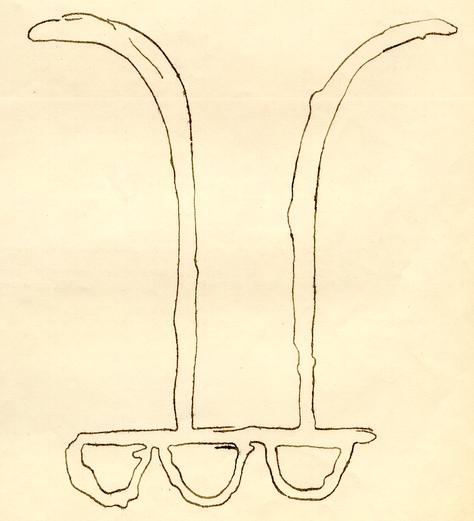 Full Size Tracing (From Rubbing) of Cypher
on South Face of Post V.
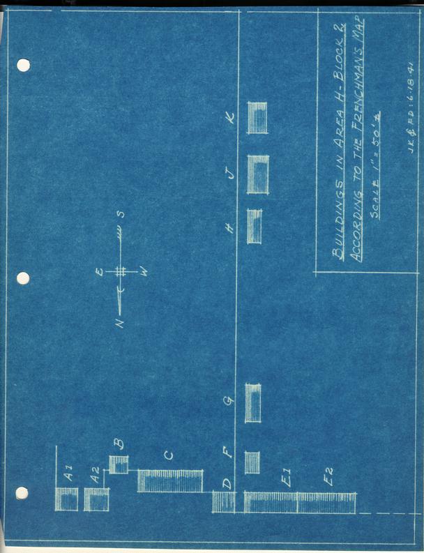 BUILDINGS IN AREA H-BLOCK 2 ACCORDING TO THE FRANCHMAN'S MAP SCALE 1" = 50'±