The Benjamin Waller Garden (Block 1 Building 16) Architectural Report Benjamin Waller House Architectural Report, Block 1 Building 16KOriginally entitled: "The Benjamin Waller Garden (Block 1 Building 16)"
Colonial Williamsburg Foundation Library Research Report Series - 1003
Colonial Williamsburg Foundation Library
Williamsburg, Virginia
1990
(DRAFT III)
THE BENJAMIN WALLER GARDEN
(Block 1 Building 16)
RESTORED: 1952
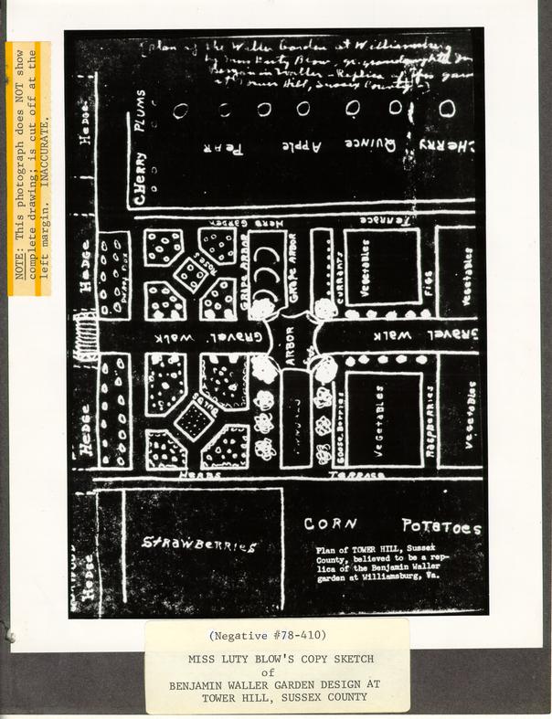
A COPY SKETCH (20th Century) BY MISS LUTY BLOW
OF
THE BENJAMIN WALLER GARDEN DESIGN
DRAWN FOR THE
TOWER HILL, SUSSEX COUNTY, VIRGINIA
GARDEN
(ca.1807)
Original Manuscript Drawing Missing
Luty Blow Ms. Copy Sketch Missing
| Facsimiles: | Slide #76-1047 and Negative #78-410 |
| (black-&-white - cropped of salient notes) | |
| Audio-Visual Library | |
| The Colonial Williamsburg Foundation | |
| Williamsburg, Virginia | |
| Photostats and Bluelines | |
| Architects' Office | |
| The Colonial Williamsburg Foundation | |
| Williamsburg, Virginia |
Catherine S. Schlesinger
Architectural Research Associate
March 22, 1978
Revisions Typed: April 17, 1980 and July 15, 1980.
THE BENJAMIN WALLER GARDEN: TOWER HILL (BLOW) SKETCH
(Block 1 Building 16)
Restored: 1952
The Colonial Williamsburg Foundation
COPY SKETCH BY MISS LUTY BLOW, NORFOLK, VIRGINIA (ca. 1940?) OF THE BENJAMIN WALLER GARDEN DESIGN IN WILLIAMSBURG, VIRGINIA. DRAWN FOR DUPLICATION AT TOWER HILL, SUSSEX COUNTY, VIRGINIA (ca. 1807).
For nearly thirty years, inaccuracies and misconceptions about a manuscript sketch of the Benjamin Waller Garden have obscured the facts concerning it. First of all, there are two sketches in question, not one. Both evidently have disappeared.
These documents first came to the attention of Colonial Williams- burg through Miss Mary A. Stephenson, who worked in the Research Department from 1945-1966. She had a copy of the sketch, done by Miss Luty Blow of Norfolk, Virginia, a descendant of the owner who drew it. At an unknown date, but probably around the time that the Benjamin Waller property was restored (1951-1953), Miss Stephenson gave her copy sketch to Alden Hopkins, Resident Landscape Architect at Colonial Williamsburg. It was not found among his papers at his death in 1960, having been borrowed, it seems, just previously. Facsimile, however, remain in the Architects' Office and Audio- Visual Library today.
The original sketch supposedly was drawn by Benjamin Waller's granddaughter, Eliza (Waller) Blow, sometime around the date of her marriage to George Blow of "Tower Hill" in Sussex County, Virginia. Family tradition maintained that the bride wanted to recreate at her new home the Williamsburg garden familiar from childhood. The whereabouts of this sketch now is a mystery. Miss Luty's copy sketch apparently represents a rough diagram taken from it, perhaps in the 1940s, but it too is missing.
Today only copies of her copy remain to substantiate the original drawing.
C.S.S.
April 17, 1980
THE BENJAMIN WALLER GARDEN: BLOW SKETCH (ca. 1807)
Tower Hill
Sussex County, Virginia
In the spring of 1976, while preparing acoustic guides (tape recordings) for visitors to use while touring various gardens in the Historic Area of Colonial Williamsburg, Mrs. Joan Parry Dutton investigated and resolved several inconsistencies which surround the role of the "Tower Hill Sketch" in the (1952) restoration of the Benjamin Waller Garden. She talked with Miss Mary Stephenson, who initially made the sketch available to Colonial Williamsburg, and traced many suppositions and facts concerning its provenance.
Since confusion over the background of the sketch again has arisen recently, as continually in the past, here outlined are the conclusions Mrs. Dutton derived. Interspersed along with these are other pertinent data about the drawing's history, com- piled from a variety of sources.
Mrs. Dutton's Bicentennial script for "The Benjamin Waller House Garden" explains (on page 6) the following circumstances:
"At the time of the garden's restoration in the early 1950's, except for the central marl walk, all traces of the earlier garden had disappeared. But a plan survived. In 1791 [sic], Benjamin Waller's grand-daughter 2 married George Blow of 'Tower Hill' in Sussex County across the James River. Eliza apparently loved her old home garden so well, she made a replica garden at 'Tower Hill.' She also drew a sketch of the plan of the garden, and some of her plantings at 'Tower Hill' survive today. Many years after Eliza made her sketch, her grand- daughter, Miss Lucy Blow of 'Tower Hill' --'Miss Luty' as she was called -- found the sketch in the family papers and made a copy of it. In due course, Miss Luty's copy was given to Colonial Williamsburg's landscape architect, and the Benjamin Waller garden was recreated accordingly. It was found that the proportions of the drawing fitted the area between the graveyard and the store- house [foundations' site] perfectly." 1
Most of the information in this paragraph came directly from Mrs. Dutton's conversations with Miss Stephenson, the only person then still alive whose knowledge of the sketches was firsthand. Other statements originated in permanent records now filed in Colonial Williamsburg's Archives. Essentially, however, all that is known about the sketches at present has been derived from Miss Stephenson's understanding of the circumstances involving the history and origins of the two drawings.
Mary Augusta Stephenson (1895-1978), was a native of Wakefield in Sussex County, Virginia, and closely acquainted with Miss Luty Blow through family connections and friendship. Either before, or while, Miss Stephenson was writing her book, Old Homes in Surry & Sussex (Richmond, Va.: The Dietz Press, 1942), Miss Luty showed her the Benjamin Waller Garden plan. It was said that Miss Luty's grandmother, Eliza Waller Blow (1791-1841) had drawn the diagram sometime after her marriage on December 12, 1807 to George Blow (17 -18 ) so that she 3 she could duplicate the Williamsburg landscape plan at Tower Hill.
Two obvious qualifications should be stated here, however, especially in view of the fragmentary, often conflicting, aspects of this chronicle. The fact that the drawing could have originated in Williamsburg, and been sent to Eliza Blow by her relatives, can- not be disregarded. Also, very possibly the original sketch could have represented Eliza Waller Blow's adaptation from memory of the Waller garden plan. Its absolute verisimilitude, transplanted to another locale with differing household circumstances, should not be taken for granted.
According to Mrs. Dutton's resumé, as based upon Miss Stephenson's recollections, Miss Luty herself found the sketch among the Blow Family Papers. At some unknown date, Miss Luty drew a copy of the original sketch. Mrs. Dutton's synopsis implies that this occurred before Miss Stephenson first saw it. Miss Luty's copy drawing is the version from which Colonial Williamsburg now has duplicates in blueprint [blueline], photostat, photograph, and slide forms.
Whether or not Miss Stephenson ever saw the original, documentary sketch as well as Miss Luty's copy drawing remains unclear. Probably she was familiar with both plans. It seems most likely that she had access to the original drawing and Miss Luty's sketch because the Sussex-related, Blow Family Papers (both those later dispersed by sale and those also now part of a larger collection of Blow manuscripts owned by The College of William and Mary) 2 were at Tower Hill among possessions of Miss Luty's brother until 1960. Miss Luty herself lived in Norfolk, 4 Virginia for many years. Miss Stephenson had a close association in social ties with the family, which meant that she often visited the Yorktown and Sussex County Blow relatives and kept up an exchange of correspondence with them all her life. If Miss Stephenson had not seen the original document, characteristically she would have questioned the veracity of the copy. Somewhere, moreover, she would have spoken or written a hint of doubt. She was very conservative and realistic in outlook.
Miss Stephenson described Tower Hill in her publication, Old Homes in Surry & Sussex (page 55), by mentioning that: "The remains of a formal garden, a replica of the Benjamin Waller garden in Williamsburg can still be seen." 3 (Remnants of an overgrown garden were still visible there in 1968, too, in the service yard located just behind the existing old house in the direction towards the Nottoway River. Whether vestiges are recognizable today or not is unknown.) Possibly then, around 1942, but probably later after Miss Stephenson began work in the Research Department at Colonial Williamsburg in 1945, Miss Luty gave her the copy sketch she had drawn. Both women certainly recognized its value as a reference source for landscape research here. Miss Stephenson thus was instrumental in bringing the garden plan "back" to Williamsburg.
There seems never to have been any doubt in her mind that the copy drawing accurately depicted the Waller garden. Nor did any of her statements indicate that hers was anything but Miss Luty's duplicate version. Whether or not it could have been a second copy, made 5 expressly for her to give to Colonial Williamsburg, seems remote albeit unchallenged by research.
Miss Stephenson's handwriting appears at the top of the sketch (Figures _ and _ ) where she penned a notation identifying it as a "[plan of the Waller Garden at Williamsburg by Miss Luty Blow, gr. granddaughter Judge Benjamin Waller -- Replica of this garden at Tower Hill, Sussex County --]." That note evidently declared her belief that the drawing portrayed the historic Waller garden rather than its later, theoretically identical, derivative across the river.
Yet seeming isn't always so. Another notation in Miss Stephen- son's handwriting, at the extreme left edge of the drawing locates "Tower Hill House" in relation to the garden. 4 Either Miss Stephen- son added that detail to record the orientation at Tower Hill for reference or it is the crucial suggestion sought which implies that the sketch in fact depicts the replica garden in Sussex County instead of the purported Waller prototype. Donald H. Parker, Director of Landscape Architecture at Colonial Williamsburg and successor to Alden Hopkins, says that the latter conclusion has always been his office's understanding of the sketch. In support, he points out the intrinsic garden features, such as the large vegetable patches, orchard, and the preponderance of domestic plantings over ornamental, which would more typify a rural, plantation setting than an urban lot. The most telling factor, however, if the orientation were assumed to be the same at both houses, is the presence of large fruit and vegetable plots (strawberries, 6 corn, and potatoes) in an area which would have been outside the boundaries of the Benjamin Waller site, overlapping the Bassett Hall property. (See: Figures _ and _ .) Archaeological excavations there in the 1950s, in other words, determined that the location of a central walkway coinciding roughly with the "gravel walk" on Miss Luty's sketch would have obviated any coeval space for such strawberry, corn, and potato patches at the east side of the Waller lot.
Other principal handwriting on the Blow sketch, which describes the garden features and plant variety (See: Attached "Plant List") can be assumed to be Miss Luty's until some comparative analysis should prove otherwise.5
Miss Stephenson's ultimate opinion of the drawing accepted its validity as a documentary footnote, while never misrepresenting or misinterpreting its probable nineteenth-century source. (Implicit proof, perhaps, of her having studied the original.) Well versed as she was in Blow/Waller records and genealogies, in combination with her knowledge of Williamsburg's history, she regarded fidelity to facts an imperative of research work. Whether wishful thinking clouded her perspective, whether she had more concrete reasons than recorded, whether her information has been misconstrued, can only be speculated today. She may even have been hesitant to ascribe it more emphasis from private doubt. Whatever the truth, and whatever the extent to which the Blow sketch is a "replica", though, it now appears most likely to be a representation of the garden growing in Sussex County from around 1807 onward.
7In this context, it seems pertinent to mention a recent observation by Frederick L. Belden, landscape architect in Colonial Williamsburg's Architects' Office. Even considering a ca. 1807 attribution date for the sketch, it still must be remembered that presumably illustrated is a garden with plantings mature, or established, in growth. That is, of course, unless the sketch depicts Eliza Blow's concept for the Tower Hill garden, which might have differed considerably from the Williamsburg example as well as her own garden when realized. Arbitrarily, then, if the Waller garden is deemed the qualified model, the garden design could be placed in a range of age reaching as far back as 1791 when Eliza Waller was born, and as far forward as 1841 when she died. To trace either garden's development, however, would require additional substantiation.
Miss Stephenson failed to mention the "Tower Hill sketch" in her (1950)6 research report on the Benjamin Waller House (Williamsburg, Va.: Colonial Williamsburg, unpublished typescript), March 1950). This silence could be interpreted as an indication that she didn't have the copy drawing in her possession in Williamsburg then or that she lacked permission from its owner(s) for reference at the time. Yet Paul Buchanan, Director of Architectural Research at Colonial Williamsburg, distinctly recalls that Miss Stephenson showed him the sketch while she was gathering research material and writing her report in 1950. (Mr. Buchanan was deeply involved in restoration of the Benjamin Waller House at the same time, the first major project he was assigned after coming to work here in 1949.) Because historical 8 studies here are based on primary sources, the drawing may have been thought inappropriate for inclusion. Similarly, the sketch's questionable late date could have been considered irrelevant to the Waller site's colonial history by Research Department standards.
An unsigned summary paper, compiled jointly by staff of the Architecture Department (including Paul Buchanan, Mario E. Campioli, Ernest M. Frank, and Alden Hopkins) two years later, however, did refer to the sketch. This paper (two pages of text with accompanying plot plan), entitled Notes on Benjamin Waller House and Garden, was prepared for distribution at a special public opening on Sunday, May 25, 1952 which marked completion of the property's restoration. Landscape information, written by Alden Hopkins, summarized:
"Detailed restoration of the garden was made possible by the success of Colonial Williams- burg's Research Department; which tracked down a sketch of the original Waller plantings that survived through Miss Luty Blow of 'Tower Hill', Sussex County. Miss Blow's grandmother, a granddaughter of [Benjamin] Waller, copied the parental garden when she came as a bride of 'Tower Hill.' " 7The landscape assessment at that period, obviously, credited the sketch as an unequivocal Waller depiction.
Use of the phrase "parental garden" in this account raises another significant point. If Eliza Waller Blow was, as recorded, the daughter of Robert Hall Waller ( -1808), who married his first wife, Nancy Camm Waller ( -1800), in 1789 and his second wife, Martha Crawford Waller ( -1816) in 1804, then the date (1791) cited earlier for 9 her marriage to George Blow must be incorrect. 8 Her wedding in fact occurred barely a year before her father's death.
Robert Hall Waller's will (dated: ; codicil dated: February 17, 1808; date of death: March ,1808), which is partially quoted on page 12 of Miss Stephenson's research report on the Benjamin Waller House, names his "Son in Law George Blow" as one of the executors of his estate. 9 This documentation establishes that Eliza Waller Blow would have had to have been born and married sometime during the nineteen-year period between 1789 and 1808. The exact date, given on page 2 above, was found in 1978 among Miss Stephenson's private research papers but primary substantiation is lacking.
The first reference among Colonial Williamsburg's research materials assigning a specific year to Eliza Waller Blow's marriage is Mrs. Dutton's (1976) script, but it errs in actually giving the year of her birth. She married in 1807. That discrepancy is minor, and can easily be explained as an oversight, a misunderstanding of Miss Stephenson's information or perhaps an understandable lapse in Miss Stephenson's memory after ten years away from the specific records. As a mistake, it can be considered fortuitous in being partly responsible for prompting the present effort to clarify these muddled facts about the drawings. Left to stand, however, it would be an unfortunate inaccuracy contributing further to the confusions by tacitly aging the design.
Miss Luty's copy sketch of the garden was first reproduced, probably
 Plan of TOWER HILL, Sussex County, believed to be a replica of the Benjamin Waller garden at Williamsburg, Va.
 (A.V. slide #76-1047)
Copy sketch by Miss Luty Blow of Tower Hill. Sussex County, VA. Based on Benjamin Waller Garden Design Drawn, Williamsburg, Va.
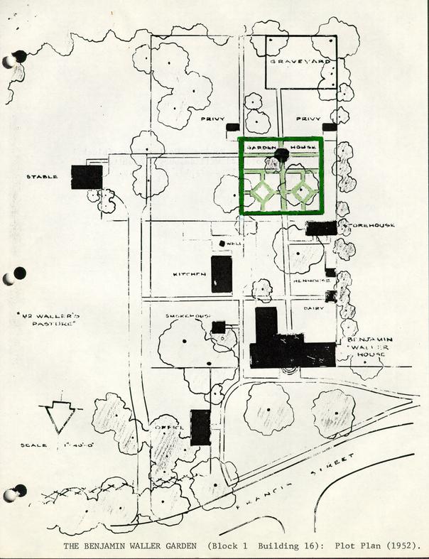 THE BENJAMIN WALLER GARDEN (Block 1 Building 16): Plot Plan (1952)
Birds eye view of Tower Hill looking South from side lane
[Illustration]
[Illustration]
THE BENJAMIN WALLER GARDEN: TOWER HILL (BLOW) SKETCH
(Block 1 Building 16)
Restored: 1952
The Colonial Williamsburg Foundation
FOOTNOTES
The last sentence in this passage, based on writings by Alden Hopkins (1950-1953), is misleading. The sketch has no scale nor dimensions, so its "proportions" would fit any space, anywhere. Furthermore, only a little more than half the layout shown on the Blow sketch was restored at the Waller site. The Benjamin Waller Garden, therefore, does not extend as far south as the walled family graveyard, it thus occupies less than three-quarters of the area available, and it is not -- in a number of respects -- a replica of the Tower Hill garden sketch. Reasons for these arbitrary adjustments have yet to be discovered, but may in part have been influenced by preferences of the Misses Morecock, life tenant residents of the Waller House when it was restored.
This small volume was written from firsthand knowledge, family papers, interviews, and manuscript research in the Sussex and Surry counties' Clerk's Offices as a private endeavor, which the was later persuaded to publish for a fund-raising project of the Wakefield Woman's Club. While never intended as an academic treatise, it nonetheless remains an invaluable source for information and photographs particularly of houses no longer in existence.
It is also possible that Colonial Williamsburg's copies of the sketch do not show the entirety of the original drawing. When compared with a drawing of Tower Hill by Major William N. Blow that dates from the early 1890s (Blow Family Papers, Swem Library, The College of William and Mary), the garden appears much more extensive than Miss Luty's diagram. Her sketch, furthermore, appears cut off abruptly at the right-hand margin. Whether Colonial Williamsburg's copies are truncated or not would be impossible to determine unless both original sketches could be located for study. Major Blow's color-drawing is published in black-and-white in A. Lawrence Kocher and Howard Dearstyne's Shadows in Silver, New York: Charles Scribner's Sons, 1954, pages 108-109, Figure III-58.
Codicil dated February 17, 1808. Blow Family Papers, Jurgenson Collection, Swem Library, The College of William and Mary. See also: Mary A. Stephenson, Benjamin Waller House, Williamsburg, Va.: Colonial Williamsburg (unpublished research report), 1950, page 12. Footnote 3 states that: "An inventory of the estate of Robert Hall Waller by George Blow, executor, appears in the Richard Blow Papers, Box 38 [Mss. Collection, Swem Library] , The College of William and Mary, Williamsburg, Virginia.
Birds-eye View of Tower Hill, looking south
Tower Hill - Sussex County
xerox illustration from FLB's files.
Same (Blow Papers College of W & M) sketch as that is illustrated in Kocher and Dearstyne's Shadows in Silver (N. Y.: Scribner's, 1954), pp. 108-109, but this one is obviously from another publication. (See: different captions, etc.) Source unknown.
View of Tower Hill, Sussex County, drawn by Major William N. Blow in the early 90's to represent the Homeplace or headquarters of the plantation as it appeared about 1861.
KEY
- 1.Great House
- 2.Overflow guest houses
- 3.Kitchen & weaving house
- 4.Dairy
- 5.Storehouses
- 6.Smokehouses
- 7.Craft shops
- 8.Wash house (laundry)
- 9.Servants' quarters
- 10.Brick yard & kiln
- 11.Presses
- 12.Cider mill
- 13.Cotton gin
- 14.Smithy
- 15.Stables
- 16.Race horse stables
- 17.Fattening pen -- hogs
- 18.Wagon sheds
- 19.Corn cribs
- 20.Carriage house
- 21.Granary & saddle room
- 22.Overseer's quarter
- 23.Poultry
- 24.Cabins for field hands
- 25.Peach orchard
- 26.Main approach
- 27."Old House"
- 28."Railroad" to marl bed (Still an ice house beyond picture, grist mill by river.)
TOWER HILL - BENJAMIN WALLER GARDEN
III - 58 View of Tower Hill, Sussex County, drawn by Major William N. Blow in the early 90's to represent the Homeplace or headquarters of the plantation as it appeared about 1861.
The Blow family settled in Sussex in the middle of the 17th century and has owned the particular tract known as Tower Hill for 175 years. Mrs. Robert
109
[Illustration]
Jurgesen, great-granddaughter of Major Blow, now owns the property. Part of these plantation lands were acquired by the Blows from the Nottoway Indians.
Tower Hill, not being directly in the path of that steamroller, Progress, only got aide-swiped a bit and continued to run along pretty much as in pre-war days down to the time the Major made his drawings. It is chiefly for this reason that 110 he was able to give us such a complete picture of the Tower Hill house and outbuildings-as they looked in the days of the "peculiar institution."
The original mansion, which was destroyed by fire, stood on the hill in the background. The dwelling we see here, into which the family moved, had been built for the plantation manager in 1775. The main approach is via the road at the right. The fence in the centerground largely separates the living, "aristocratic", part of the plantation from the business or laboring part. Tower Hill was virtually self-sufficient, raising and processing its own meat, drink and produce and manufacturing its bricks, its wood, leather and metal products, its cloths and its clothing. The land under cultivation, for the most part not shown here, was divided into three farms, known as the Home Tract, Island Tract end Mill Tract.
KEY
- 1.Great House
- 2.Overflow guest houses
- 3.Kitchen & weaving house
- 4.Dairy
- 5.Storehouses
- 6.Smokehouses
- 7.Craft shops
- 8.Wash house (laundry)
- 9.Servants' quarters
- 10.Brick yard & kiln
- 11.Presses
- 12.Cider mill
- 13.Cotton gin
- 14.Smithy
- 15.Stables
- 16.Race horse stables
- 17.Fattening pen-hogs
- 18.Wagon sheds
- 19.Corn cribs
- 20.Carriage house
- 21.Granary & saddle room
- 22.Overseer's quarters
- 23.Poultry
- 24.Cabins for field hands
- 25.Peach orchard
- 26.Main approach
- 27."Old House"
- 28."Railroad" to marl bed (Still and ice house beyond picture, grist mill by river.)
III - 59 This remarkable portrait of Edmund Ruffin, taken by George S. Cook in Charleston immediately before the War Between the States, is that of an embittered man, a fierce secessionist who prided himself on having fired, against Fort Sumter, the first shot in the bloody conflict which brought devastation and ruin to his homeland and changed the order of life in the entire South. He was, as Avery Craven says, "a strange bundle of contradictions. Kind and loving with his children, generous to the worthy who needed, strong and loyal in friendship, lie could hate with equal power, until his blood estranged could be viewed with complete indifference and friends of long standing instantly turned into enemies to be forever afterward passed by. Slow to anger, his 'resentment,' when aroused, was implacable… "
Such was the character of Edmund Ruffin of Coggin's Point, Prince George County-a man whose vindictiveness was, except in the short view, a liability to the South. But there was a vein of greatness running through the dross which is so conspicuous in his character. It was, after all, he whose intelligence, perseverance and courage saved the agriculture of Virginia and the South when the blight of soured and worn-out soils had brought about the desertion of the "old fields" and an exodus westward to the new and unexploited lands. He braved the ridicule of his close neighbors and friends and carried to triumphant success his epoch-making experiments in the use of marl-lime-to restore exhausted soils. His An Essay on Calcareous Manures was hailed by a government expert in 1895 as "the most thorough piece of work on a special agricultural subject in the English language." This was, however, but the most important of his many written works on agricultural subjects. He was founder and for over ten years editor of the Farmers' Register in which he campaigned indefatigably for the application of scientific knowledge to agriculture and set farmers to thinking about new methods of preparing and cultivating the land.
OLD HOMES
in
SURRY & SUSSEX
RICHMOND, VA.
THE DIETZ PRESS, Publishers
1942
[Title Page - Old Homes in Surry & Sussex]
TOWER HILL
Home of the Blows on the Nottoway
Tower Hill, stands amid its wooded lands, a solitary fragment of a past once pregnant with vital living. Though it is unoccupied, yet, after all these years, the spirit and traditions are alive.
The tract of land known as "Tower Hill," was part of an original grant to Benjamin Harrison of Berkeley, father of Benjamin Harrison, Signer of the Declaration of Independence. Another part of Tower Hill was acquired by Richard Blow (died 1762), and here on this land he settled his son, Samuel Blow. In 1774, on November 9, Richard Blow, son of Samuel Blow, bought from Col: Syme "for the consideration of 950 pounds current money of Virginia, all that tract of land situate and being on the south side of the River Nottoway in the County of Sussex which John Syme purchased of Henry Harrison late of Sussex County."
55[…] called to consider Secession, a member of the Texas Convention applying for statehood, and a Judge of the First judicial Circuit of Virginia for sixteen years.
William Nivison Blow, son of Col. George Blow, served as Captain of the Sussex troops in the War Between the States. He married Lavinia Cargill, daughter of Capt. John Cargill of Invermay. He inherited Tower Hill and lived there until his death. In later years it has been the property of Major William Nivison Blow, who left it to his wife, Mary Thomas Blow and their son, William Thomas Blow.
Col. George Blow was a close personal friend of Hon. John Y. Mason, member of Congress and a Judge. In a letter to Judge Mason, Col. Blow expressed his views on Nullification, and the results expected, should it be put into effect. This letter proved almost a prophesy.
Like their kinsman, the Harrisons, the Blows were great lovers of hunting, and fine race horses. One of their thoroughbreds, Jupiter, was well known in hunting circles as of imported stock. Another, Iris, was of blooded stock and well known on the tracks. They also kept fine dogs which were entered in the shows.
The house is the true type story-and-a-half with dormer windows. It has suffered some changes but in the main it stands as first built. Located on rolling ground it overlooks several acres of green fields. The remains of a formal garden, a replica of the Benjamin Waller garden in Williamsburg, can still be seen.
By marriage, this family is related to many in Sussex, Surry, and eastern Virginia: Waller, Wright, Ruffin, Mason, Drew, Hunter, Allmand, Camm, Blacknall, and Harrison.
NEW HOPE
JUST a few years ago, New Hope, the home of the Pace family, was razed by the Williamsburg Restoration and taken to Williamsburg. At that time this home was owned by the Surry Lumber Company. It is said that much of the timber, woodwork and doors were used in restoring the Capitol and the Governor's Palace. Many in Sussex recall the beauty of line and proportion which made this house distinctive.
During the period around 1860, John James Pace purchased it from Walter B. Scott who had acquired it by gift from his uncle, Bolden New. Without doubt, before that time it was a Chappell and a Briggs plantation. It lay near unto the Indian village known as "Old Town" or "Indian Town" on Assamoosick Swamp and adjoined the Montrose plantation of the Land family, and the lands of John Mason Wyche afterwards called the "Cobb Place." New Hope was probably the home of Major Charles Briggs, who inherited it from his father, George Briggs, in 1759, which tract was given to the said Briggs by the Chief of the Nottoway Indians.
The Muster Field used in the Revolution, War of 1812, and the War Between the States adjoined this plantation.
A DREWRY HOME
This home, about one hundred and fifty years old, has been owned by the Drewry family for fifty years. At one time, Henry Q. Moyler lived here.
The Gardens of Williamsburg
Restricted to C.W. Personnel
RESTRICTED
BENJAMIN WALLER
The crude drawing of a garden at the Sussex County plantation, Tower Hill, led to the present form of the Benjamin Waller garden. This drawing, a unique survivor among the documentary evidence for Williamsburg's restoration, was found in the papers of Miss Luty Blow, a granddaughter of Elizabeth Waller. Prior to her marriage in 1791, Elizabeth and her parents, the Robert Hall Wallers, had lived for many years with her grandfather in Williamsburg, where she became devoted to his garden. This affection for her childhood home was reflected in her garden at Tower Hill. Fortunately its proportions fitted almost perfectly into the location where the garden was known to have existed on her great-great grandfather's property. 25
Littleton Waller Tazewell, a grandson of Benjamin Waller, mentions in his autobiography that his grandparents were married on the night the Capitol burned: January 30, 1747. Benjamin's house, which he had probably already begun to build, occupied the last lot at the far southeastern end of Francis Street. Identification of the lot would have been difficult had it not been for a map drawn in 1749 on which his brother, William Waller, designated it. The map; however, did not show any buildings or gardens. In fact, there is no reference to the existence of a garden during Benjamin Waller's lifetime--a curious circumstance in view of the prominent position he attained as a lawyer, judge, and citizen. The 1807 will of the youngest of his twelve children, Robert Hall Waller, specifically mentions a garden. Robert referred to the "Grave Yd in the corner of the Garden." As this graveyard has remained intact on its original site, the position of the garden was not difficult to locate.
Except for the clues on the Blow map, the appearance of the garden is not hinted at in any of the other historical records. There are no items in the accounts for seeds, plants, garden tools, or other materials (except for fences) that carry any incidental information about its design or maintenance. There must have been a garden worthy of enclosure in 1317, while the property was owned by George Blow, son-in-law of Robert Hall Waller, when a contract 135. was made with William Hewlett, carpenter, to provide a fence around the "Garden & Yard." There is also considerable archaeological evidence to establish the main outlines of the garden area. 26
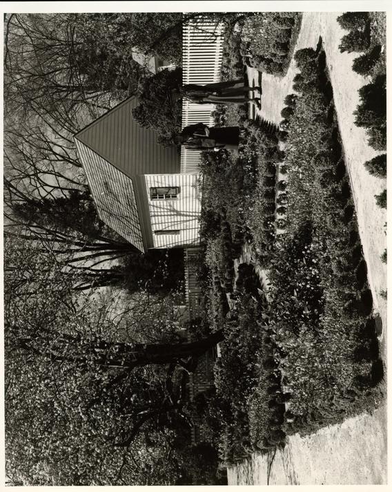
When Colonial Williamsburg bought the property in 1941 it had been out of the Waller family for 56 years, but the main house, still standing, corresponded closely to the larger of two buildings shown on the Frenchman's Map (1722) and the Rochambeau Map of the same year. The original smokehouse was also standing. Further signs of the original outbuildings turned up in the archaeological excavations of 1950, which brought to light foundations of a dairy, henhouse, storehouse, well, kitchen, stable, office, a brick drain, and garden walks constructed of marl. These walks, particularly the one leading from the rear porch of the house to she graveyard gate, were the most important clue to the layout of the garden. They also formed the skeleton for a miniature plantation, usually referred to in contemporary descriptions as the "yard," as distinct from the "garden."
Restoration of the "garden and yard" centers on the existing eighteenth-century marl walk. Fence lines were determined partly by postholes and partly by the location of the outbuildings in relation to service areas. The fence pickets themselves are an exact reproduction of the original design made possible by the discovery of an eighteenth-century picket used as furring in the dormers of the roof rafters in the house. This unique discovery of a tulip-form picket contributed a valuable detail to the restoration of colonial gardens traditionally enclosed by fences of this type.
Between this utilitarian area and the family cemetery at the rear of the lot was the garden location referred to in Robert Hall Waller's will. The major proportions of the Blow drawing made possible its completely plausible adaptation to the Benjamin Waller site. Although the parterre pattern was not followed exactly, the arbored crosswalk, with a pavilion at the intersection, was simulated. Probably Benjamin Waller and his granddaughter would feel very much at home strolling in their "Garden and Yard" as it appears today: the geometric beds of periwinkle and flowering bulbs outlined with 136. neatly trimmed boxwood, the vine-covered pavilion surrounded by native shadbush, the Cherokee rose arbor, the rows of azaleas and pomegranate, the scent of boxwood mingled with winter sweet and rose.
The enlarged scale of work in feeding and caring for a family of the size that Waller's ultimately reached is suggested by the number of outbuildings grouped efficiently but attractively around the yard. In front of the kitchen a generous semicircular brickpaved area, unearthed by the archaeological excavations, suggests activities expanding to the outside when heat or congestion made it unpleasant to work, inside, the building. Within this workyard it is easy to imagine the everyday activity of drawing water from the well, gathering eggs and feeding chickens, tending to milk and butter in the dairy, placing hickory bark on the fire pit in the smokehouse, washing and hanging out clothes to dry: Only the movement, the noises, and the odors are needed to fill out the scene.
In the front yard a small office stands at right angles to the main house, facing straight down Francis Street. This building, which appeared on the Frenchman's Map and was verified by archaeology, has beer identified as Benjamin Waller's private law office. In front of it on the Frenchman's Map appear three small double dots that have been variously interpreted but when they are compared to similar indications on the Sauthier maps, it seems clear that they are conventional indications for trees with their shadows cast diagonally to she right. Since a shaded side is also indicated for the roof of the building in this same direction, there can be little doubt that this was the mapmaker's method of showing a third dimension. In this case the landscape architect has interpreted the dots by planting quince. Foundations unearthed in the adjacent area identified on the William Waller plow plan as "Mr. Waller's Pasture" have been identified as the stable, now reconstructed and used as a garage. This building, the last to be identified, makes the Waller urban plantation one of the most complete and long-enduring residential groups in Williamsburg.