A Report on Exploratory Excavations at Carter's Grove Plantation
Colonial Williamsburg Foundation Library Research Report Series - 273
Colonial Williamsburg Foundation Library
Williamsburg, Virginia
1990
A REPORT ON EXPLORATORY EXCAVATIONS AT
CARTER'S GROVE PLANTATION
JAMES CITY COUNTY, VIRGINIA
(JUNE 1970 - SEPTEMBER 1971)
| Page | |
| TABLE OF FIGURES | iii. |
| TABLE OF PHOTOGRAPHS | v. |
| PREFACE | ix. |
| I. INTRODUCTION | |
| A. Objectives | 1 |
| B. Location | 1 |
| C. Summary Description of Archaeological Features | 2 |
| II. HISTORY | 4 |
| III. ARCHAEOLOGY | |
| A. Plan of Excavation | 6 |
| 1. Grid and Test Squares, Summer 1970 | 6 |
| 2. Machine Trenching | 7 |
| B. Eighteenth-Century Architectural and/or Related Features | 9 |
| 1. Garden | 9 |
| a. First Period Fenceline | 10 |
| b. Second Period Fenceline | 11 |
| c. Intermediate Fenceline | 13 |
| d. Third Period Fenceline | 13 |
| e. Gates14f. Path System | 15 |
| g. Garden Plots | 16 |
| h. Ditches | 17 |
| i. Terrace Ramp | 18 |
| j. Terrace | 18 |
| k. Historical Evidence | 20 |
| 2. Dairy (?) Building | 22 |
| 3. 1782 House Site | 25 |
| 4. Icehouse Pit(?) | 27 |
| a. Pit A | 28 |
| b. Pit B | 28 |
| c. Terrace Fill | 29 |
| 5. Main Entrance Road | 31 |
| 6. Landing Road(?) | 32 |
| C. Eighteenth-Century Craft Related Features | 33 |
| 1. Tannery(?) and Pits | 33 |
| a. Tanning Vats(?) — Pit A and Pit B | 33 |
| b. Smaller Rectangular Pits | 36 |
| c. Relationship and Interpretation | 37 |
| d. Other Features 412. Brickyard | 43 |
| 2. Brickyard | 43 |
| a. Brick Clamps | 44 |
| Clamp 1 | 44 |
| Clamp 2 | 44 |
| Clamp 3 | 45 |
| Clamp 4 | 47 |
| Clamp 5 | 48 |
| b. Clay Pits | 49 |
| c. The Wells | 50 |
| Well A | 50 |
| Well B | 55 |
| ii. | |
| d. Small Pits | 60 |
| e. Interpretation | 60 |
| 3. Other Features Possibly Related to Crafts | 63 |
| a. Square-Ditched Feature (CG 940) | 64 |
| b. Feature CG 980 | 65 |
| c. CG 960, Eight Posthole Structure(?) | 67 |
| D. Seventeenth-Century Features | 67 |
| 1. Field 7 | 67 |
| 2. Field 8 | 68 |
| 3. Field 9 | 68 |
| 4. Field 11 | 68 |
| 5. Field 13 | 70 |
| 6. Wooded Hill Occupation | 70 |
| E. Indian Site — Field 9 | 71 |
| F. Distribution of Colonial Ceramic Sherds in the Vicinity of the Mansion | 72 |
| G. Concluding Remarks | 73 |
| VI. FOOTNOTES | 76 |
| VII. APPENDIX | |
| I. Stratigraphy | 79 |
| II. Dating List | 94 |
| III. Table of Brick Sizes | 99 |
| IV. 1875 Plate of Carter's Grove | 99A |
| V. Archaeological Evidence Discovered in the "Boxwood Garden" and the Area North of the Kitchen. | 100 |
| VI. Description of Strata and Features Mentioned in Appendix V | 112 |
| VII. Dating of Groups From Area's North and East of the Kitchen | 115 |
| VIII. A Faunal Analysis of Wells A and B | 119 |
| Figure Number | Brief Description | Location |
|---|---|---|
| Figure 1 | Site master plan | Front jacket |
| Figure 2 | Field numbering system | Following page ix |
| Figure 3 | Map location of Carter's Grove | " " 1 |
| Figure 4 | Segment of the Desandrouin Map | " " 5 |
| Figure 5 | Sketch plan of the garden | " " 9 |
| Figure 6 | E/W section thru garden fenceline | " " 16 |
| Figure 7 | Portion of the Simcoe Map | " " 21 |
| Figure 8 | Dairy (?) building plan | " " 22 |
| Figure 9 | Plan of 1782 house (?), field 5 | " " 26 |
| Figure 10 | Icehouse (?) pit plan | " " 28 |
| Figure 11 | N/S section thru icehouse (?) pits | " " 28 |
| Figure 12 | Plan of tanning (?) pits, filed 13 | " " 33 |
| Figure 13 | Plan of pits A and B | " " 34 |
| Figure 14 | N/S section thru pits A and B | " " 34 |
| Figure 15 | Brickyard plan | " " 44 |
| Figure 16 | Section thru Well A | " " 51 |
| Figure 17 | Section thru Well B | " " 56 |
| Figure 18 | 18th-century sketch of a brickyard | " " 57 |
| Figure 19 | Wooden artifacts from Well B | " " 58 |
| Figure 20 | 18th-century French brickyard | " " 60 |
| Figure 21 | 18th-century Brickyard | " " 61 |
| Figure 22 | Plan of feature CG 940, field 14 | " " 64 |
| Figure 23 | Plan of feature CG 960, field 14 | " " 67 |
| Figure 24 | Features south of the mansion | " " 71 |
| Figure 25 | Features north of the mansion | " " 71 |
| Figure 26 | Features in the extreme north end of the property | " " 71 |
| Figure 27 | Artifact distribution plan | " " 72 |
| iv. | ||
| Figure 28 | Garden master plan | Rear jacket |
| Figure 29 | Features northeast of kitchen | Following page 100 |
| Figure 30 | N/S section near well in "boxwood garden" | " " 102 |
| Figure 31 | E/W section of strata north of the kitchen | " " 108 |
| Figure 32 | N/S section beneath marl drive located north of kitchen | " " 109 |
| Plate Number | Brief Description | Location |
|---|---|---|
| Plate I. | Aerial view of Carter's Grove garden during excavation. | Following page 9 |
| Plate II. | South paddock area garden fence postholes before excavation. | " " 9 |
| Plate III. | First and second period garden postholes before excavation. | " " 9 |
| Plate IV. | Trench CG 1592 showing first and second period garden fenceline postholes after excavation. | " " 9 |
| Plate V. | Feature CG 1539 showing second and third period garden fenceline postholes cutting into first period postholes. | " " 10 |
| Plate VI. | Trenches CG 1596, CG 1555, showing first and second period garden fenceline postholes cut into original grade of terrace flank. | " " 11 |
| Plate VII. | Trench CG 1540 showing partially excavated second period garden excavated second period garden fence posthole (CG 1540C) with post in situ. | " " 11 |
| Plate VIII. | Trench CG 1525 showing first and second period garden fenceline second period garden fenceline postholes as they ascend the first tier of the terrace. | " " 11 |
| Plate IX. | Trench CG 1553, CG 1586-89 showing three periods of garden fenceline postholes after excavation. | " " 13 |
| Plate X. | First (CG 1492-93) and second (CG 1479-80) period garden fenceline gate postholes. | " " 14 |
| Plate XI. | Photograph showing the terrace ramp, original terrace grade and curb(?),and junction of central garden path with crosspath 3. | " " 18 |
| Plate XII. | 1907-1910 photograph showing crude dirt terrace ramp still in use. | " " 18 |
| Plate XIII. | Photograph showing the relationship of the dairy(?) building foundation to the mansion. | " " 22 |
| Plate XIV. | Overhead view of dairy(?) building foundation after excavation. | " " 22 |
| vi. | ||
| Plate XV. | Blue shell-edged octagonal ironstone plate sherd (CG 210AC) of the period 1840-60 in situ beneath south foundation of dairy (?) building. | Following page 23 |
| Plate XVI. | Iron plow point with 1857 patent date (CG 210AY) sealed beneath brick underpin, north wall of dairy (?) building. | " " 23 |
| Plate XVII. | Eight postholes (scaffold holes) found in field 5 at the approximate location of a rectangular structure shown on the Desandrouins Map of 1782. | " " 26 |
| Plate XVIII. | Icehouse pit (?) Pit A (CG 460) on west terrace flank and cross section through sandy fill (CG 439B) from terrace construction(?). | " " 28 |
| Plate XIX. | Original topsoil level (CG 439C) containing brick rubble (from construction of mansion outbuildings (?) found beneath sandy fill (CG 439B) from terrace construction (?). | " " 29 |
| Plate XX. | Wine bottle ca.1730-45 (CG 439B) in situ on brick rubble and original topsoil spread (CG 439C) south of icehouse (?) pit (Pit A). | " " 29 |
| Plate XXI. | Partially excavated main entrance road ditches located near Route 60, field 6. | " " 31 |
| Plate XXII. | Tanning (?) pits in north end of field 13. | " " 33 |
| Plate XXIII. | Wood-lined tanning pits (?) before excavation. | " " 33 |
| Plate XXIV. | Wood-lined tanning (?) pit (Pit A, CG 715) showing north-south cross section through fill and domestic trash in situ. | " " 35 |
| Plate XXV. | Wood-lined tanning (?) pit (Pit B, CG 716) showing north-south cross section through fill (background) and domestic refuse in situ. | " " 35 |
| Plate XXVI. | Pit C (CG 702), field 13 showing bricks in situ along south wall of feature. | " " 36 |
| Plate XXVII. | Typical creamware types from the small rectangular pit area, field 13. | " " 36 |
| vii. | ||
| Plate XXVIII. | Two of ten pewter spoons recovered from the fill in the small rectangular pits, field 13. | Following page 36 |
| Plate XXIX. | Pit N field 13 (CG 721) showing of north-south cross-section through fill above scorched clay floor. | " " 37 |
| Plate XXX. | Rectangular wood-lined tanning vats as sketched in 1808. | " " 39 |
| Plate XXXI. | Brick clamp 2, field 8. | " " 44 |
| Plate XXXII. | Aerial view of brick clamps 3 and 4. | " " 45 |
| Plate XXXIII. | Brick clamp 3 partially excavated. | " " 45 |
| Plate XXXIV. | Charred central supporting post in situ in posthole CG 1203A, brick clamp 3. | " " 45 |
| Plate XXXV. | Relative proximity of the two wells which were presumed to have been used to provide water for the brickmaking operation. | " " 50 |
| Plate XXXVI. | Upper portion of the wooden lining found in Well A. | " " 51 |
| Plate XXXVII. | The northwest corner of the wooded lining found in Well A. | " " 51 |
| Plate XXXVIII. | A portion of an oak paddle found in Well A. | " " 52 |
| Plate XXXIX. | Two fragments of an iron hoe blade found in different levels of Well A's filling. | " " 52 |
| Plate XL. | The upper lining in Well B, made from regular bricks, which showed signs of imminent collapse. | " " 55 |
| Plate XLI. | Typical 18th century compass brick-lined well shaft but this type of construction was only used in the bottom 6' 10" of Well B. | " " 56 |
| Plate XLII. | Five compass bricks wedged vertically behind Well B's lining. | " " 56 |
| Plate XLIII. | Crudely constructed wooden curb found beneath the last course of bricks in Well B. | " " 56 |
| Plate XLIV. | Iron hoe blade with the maker's mark "WK" stamped three times near the end of the rib. | " " 57 |
| viii. | ||
| Plate XLV. | Iron axe blade with the maker's mark "W. DEAS" stamped three times near the center. | Following page 57 |
| Plate XLVI. | Wine bottles of the period ca. 1740-55 which provided dating, evidence for the brickyard. | " " 58 |
| Plate XLVII. | Feature CG 940, field 14 showing square pit and right-angled drainage ditch. | " " 64 |
| Plate XLVIII. | Mortising axe found in the fill of feature CG 940. | " " 65 |
| Plate XLIX. | Examples of worked bricks found feature CG 980, field 14. | " " 66 |
| Plate L. | Feature CG 960, field 14 showing symmetrical arrangement of postholes. | " " 67 |
| Plate LI. | Typical clay tobacco pipe bowls found in association with seventeenth-century features. | " " 67 |
| Plate LII. | Delftware sherds found in a trash deposit (CG 989), field 7. | " " 67 |
| Plate LIII. | Earthenware sherds found in fields 7 and 9. | " " 67 |
| Plate LIV. | Chinese porcelain fragments found in the vicinity of the mansion. | " " 72 |
| Plate LV. | Excavated well shaft located in "Boxwood Garden". | " " 100 |
| Plate LVI. | Yard levels surrounding well in "Boxwood Garden". | " " 102 |
| Plate LVII. | Paving(?) near well in "Boxwood Garden". | " " 102 |
| Plate LVIII. | Brick rubble located north of the kitchen. | " " 109 |
PREFACE
The following report is an attempt to summarize fifteen months of archaeological field work conducted at Carter's Grove Plantation. It cannot be a comprehensive final archaeological report — not enough time was allotted for it, most of the archaeological features encountered were not entirely excavated, and not all of the site (400 acres) was investigated. However, the attempt has been made to present in some detail the archaeological evidence that will be of help to the Colonial Williamsburg Foundation in its projected plan to re-establish Carter's Grove as a working eighteenth-century plantation. For this reason, evidence of earlier occupation at the site was not excavated in detail and will only be presented in summary form. Also, because of the report time factor, only the artifacts essential to the dating and/or interpretation of a feature have been discussed.
Because of the tremendous size of the site and the variety and scattered nature of its archaeological features, it was extremely difficult to organize and present a cohesive report without the use of a considerable amount of cross-referencing and the inclusion of foldout plans. To aid in cross-referencing, the table of contents has been presented in enough detail to serve as a quick index. Also, to help the reader locate features, key foldout
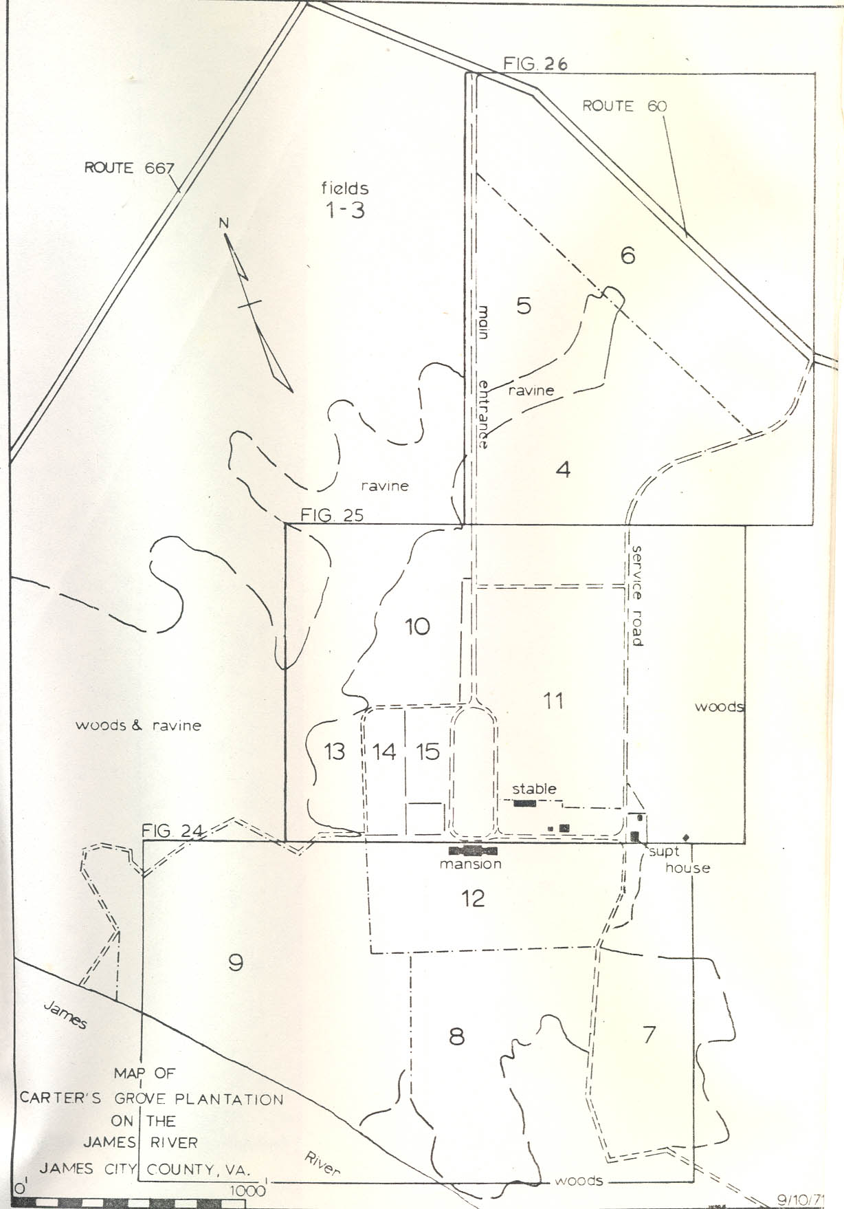 Figure 1 — Woods and Ravine
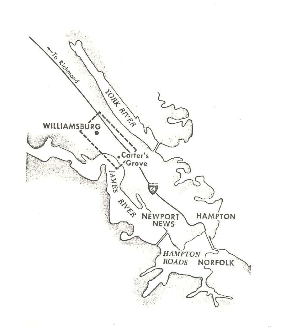 Figure 2
x.
drawings have been placed either in the front and rear jackets, at the end of the text, or following a particular textual description. For example, the overall archaeological site plan (Figure 1) has been placed in the front jacket of the report, but because of its size, it has been divided and presented on a smaller scale in foldout form at the rear of the text (Figures 24, 25, & 26).1 Also, a small foldout map of the site appears near the front (see Figure 2, facing page) as a quick reference. Hopefully, this will enable the reader to generally follow location references by glancing at the smaller foldouts or (if necessary) to specifically orient widely scattered features by referring to the larger scale map in the front jacket. In the same way, the reader can fold out Figures 12 or 15 located near the end of the discussion of particular archaeological features; then keep the plan in view as he reviews the textual description.
Figure 2
x.
drawings have been placed either in the front and rear jackets, at the end of the text, or following a particular textual description. For example, the overall archaeological site plan (Figure 1) has been placed in the front jacket of the report, but because of its size, it has been divided and presented on a smaller scale in foldout form at the rear of the text (Figures 24, 25, & 26).1 Also, a small foldout map of the site appears near the front (see Figure 2, facing page) as a quick reference. Hopefully, this will enable the reader to generally follow location references by glancing at the smaller foldouts or (if necessary) to specifically orient widely scattered features by referring to the larger scale map in the front jacket. In the same way, the reader can fold out Figures 12 or 15 located near the end of the discussion of particular archaeological features; then keep the plan in view as he reviews the textual description.
Also, the reader should note that the paragraph photo angle symbols on each illustration refer to the plate number of this report. The abbreviation CG means Carter's Grove Excavation Register, BMG means depth below modern grade, and BNG means depth below the surface of the natural, undisturbed grade.
R. Neil Frank Colonial Williamsburg archaeologist, was in charge of the excavation of the two wells located in the brickyard (Field 8) south of the mansion, and pages 50 to 59 were written by him.
xi.All of the drawings except Figs. 19 and 20 were done by the author.
The author conducted the work under contract with the Colonial Williamsburg Foundation through the Colonial Williamsburg Department of Archaeology. The project was under the overall supervision of Mr. Ivor Noël Hume who, throughout the excavation, scheduled priorities, outlined the excavation methods and shouldered some of the administrative duties.
I would like to express appreciation to the Colonial Williamsburg Foundation for supporting the project and those associated with the excavation, particularly: I. Noël Hume, David K. Hazzard, R. Neil Frank, Isabel Davies, and those serving on the field crew. Key historical references were supplied by Earl Soles, Julia Davis, and Harold Gill. Also, I would especially like to express my gratitude to Colonial Williamsburg and Mr. Peter A. G. Brown for the many courtesies extended to my family during our stay at Carter's Grove.
Carter's Grove Plantation
November 18, 1971
I. INTRODUCTION
A. Objectives
From June 8, 1970, to September 10, 1971, the author conducted exploratory excavations at Carter's Grove Plantation for the Colonial Williamsburg Foundation. The major objective of the project was to gather data to aid the reestablishment of Carter's Grove as an eighteenth-century working plantation. Therefore, one of the primary goals of archaeology was to locate evidence of eighteenth-century architectural features and to find and investigate other areas of eighteenth-century plantation activity. Also, after it became progressively obvious that the site had been occupied before the establishment of the eighteenth-century plantation, finding and marking areas of earlier habitation became another objective.
B. Location
Carter's Grove Plantation is located six miles southeast of Williamsburg on the James River (See Figure 3). The present 400-acre tract is bounded on the south by the James River, on the east by woods and Grice's Run, on the north by State Highway Route #60, and on the west by County Route 667 and the Hampton Roads Sanitation District property. The tract presently includes fifteen cleared fields and the eighteenth-century mansion with kitchen wing to the east and office wing to the west, a modern stable, watchman's house, two garages, a pump house and the superintendent's house (See Figure 2).
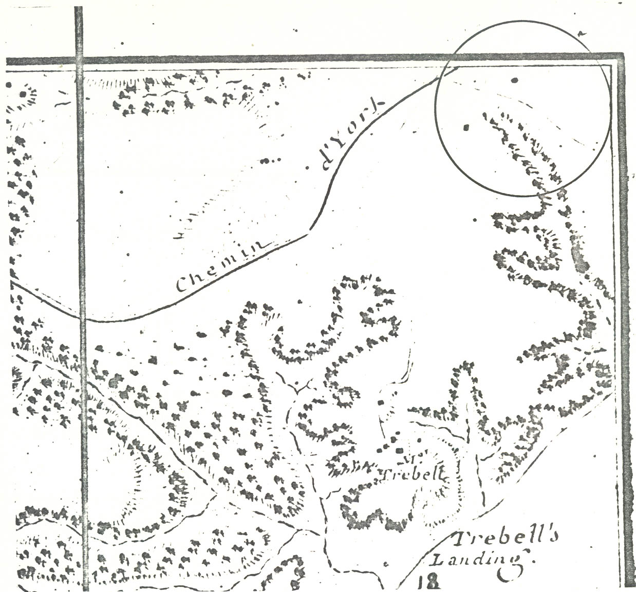 FIGURE 3 — Segment of a modern map indicating the location of Carter's Grove Plantation, James City County, Virginia
C. Summary Description of Archaeological Features
In summary, the significant eighteenth-century architectural and related features found at Carter's Grove during the course of the exploratory excavations include: (1) a formalized, enclosed garden directly south of the mansion used c.1765-1835; (2) a dairy(?) building northeast of the mansion, possibly first built in the eighteenth century; (3) the site of a house with only eight postholes surviving located about 2000' north of the mansion, probably built and occupied during the second half of the eighteenth century; (4) an icehouse(?) pit on the west flank of the terrace filled in after c.1750-1760; (5) ditches in Fields 4, 6, and 10 probably marking the route of the original entrance road; and, (6) a clay-filled road bed (CG 1082) south of the mansion leading toward the beach, probably the original route to a landing.
Eighteenth-century archaeological features related to crafts were also found, including: (1) the probable site of a tannery in Field 13 with pits backfilled during the last quarter of the eighteenth century; (2) the site of a brickyard in Field 8 with clay pits or basins, two wells, and at least five clamp (temporary kiln) sites used c.1750; and, (3) three features in Field 14 possibly related to crafts: a square shallow pit (CG 940) with a drainage ditch at one end backfilled c.1750, a backfilled ditch (CG 980) containing water table bricks matching those used in the mansion, and a feature (CG 960) consisting of two sets of four postholes, probably dug during the eighteenth century.
3.Considerable evidence of seventeenth-century occupation was found during the exploratory excavations. These features included: (1) a trash pit in Field 7 (CG 989) filled after c.1640; (2) a large backfilled pit (cellar hole?) (CG 1163-64) and a small trash pit (CG 1145) in the southeastern section of Field 9; (3) in Field 11, a probable burned building site (CG 1043), two backfilled holes (CG 1032-33), two(?) trash pits (CG 1600-01), seven human burials of unknown date (CG 1026-27, 1035, 1037-38, 1041-42) all enclosed by a substantial ditch (CG 984-85, CG 1021); (4) a rectangular pit (CG 1092) in Field 8; (5) a small trash pit (CG 741) backfilled after c.1650 in Field 13 and, (6) an occupation layer (CG 1050-60) encompassing an area about 50' square on a wooded knoll east of the superintendent's house.
Evidence of prehistoric Indian occupation was also found. An ossuary burial (CG 1015) containing the bones of at least nine individuals was located, as well as a shell midden occupation layer (CG 992, CG 993) in Field 9. This occupation dates in the period c.350-1600 A.D.
II. SUMMARY HISTORY OF CARTER'S GROVE TO 1838
During the seventeenth century, the area encompassing the Carter's Grove tract was a part of Merchant's Hundred Parish, but it is not known who lived there.2 The first known owner was Robert "King" Carter (1663-1732) of Corotoman, Lancaster County, Virginia, who purchased the plantation, presumably in the early 1720s, for his daughter Elizabeth and her husband Nathaniel Burwell of Fairfield, Gloucester County, Virginia. The plantation, known as Merchant's Hundred Plantation, produced tobacco throughout the 1720s and early 1730s, and it was probably run and occupied by overseers. When Robert Carter's grandson, Carter Burwell, came of age in 1737-38, he inherited the place and began living there.3
Carter Burwell's account books and ledgers indicate that a "House" and a "Kitchen" stood at Carter's Grove (so named after the death of Robert Carter in 1732) as early as 1739; and throughout the 1740's until his death in 1756, Carter Burwell paid for a considerable amount of building materials and construction at Carter's Grove culminating in the completion of the mansion in 1755. For example, bricks were burnt in 1744; carpenters began building a 40' house in 1745; the brick mason, David Minetree, was hired from 1749-1751 for the making and laying of bricks for the mansion; and, Richard Bayliss was paid to finish the mansion interior. Carter Burwell died in 1756.4
Nathaniel Burwell (1750-1814) inherited Carter's Grove in 1756, but his guardian, William Nelson, ran the estate until the young Burwell came of age
 FIGURE 4 — Desandrouins "Carte Des Environs De Williamsburg En Virginie…" (1782) showing two structures and the entrance road to Carter's Grove (encircled). Rochambeau Collection (#57)
5.
in 1771. During this period, repairs were made to buildings, including the barn (1786) and the "Old House" (1770).5
FIGURE 4 — Desandrouins "Carte Des Environs De Williamsburg En Virginie…" (1782) showing two structures and the entrance road to Carter's Grove (encircled). Rochambeau Collection (#57)
5.
in 1771. During this period, repairs were made to buildings, including the barn (1786) and the "Old House" (1770).5
From 1772 until 1804, Nathaniel Burwell lived at carter's Grove and employed John Ross as his overseer. In 1782 Burwell paid taxes for 1288 acres and 47 slaves. Between 1778 and 1787, Humphrey Harwood, a local brick mason, was hired to build or repair the "pillering house" (1778), "storehouse" (1783), "kitchen" and "overseer's house" (1784), and for "…mending the lathing and plaistering and bricking up the sides and back of a wooden chimney."6 The only detailed eighteenth-century map of Carter's Grove, the Desandrouin Map of 1782,7 shows that two structures (not identified) and the route of the main entrance road were located on the northeast section of the property during Nathaniel Burwell's occupancy (See Figure 4). It does not show the mansion area; therefore, where the storehouse or overseer's house, etc., were located cannot be determined from the historical records.
Soon after the construction of Carter Hall, Clarke County, Virginia (1792), Nathaniel Burwell apparently allowed Carter's Grove to be managed by his son Carter Burwell, and from 1804 until his death in 1814, Nathaniel Burwell only spent the winter at Carter's Grove.[8]
Carter's Grove remained under the management of Carter Burwell until his death in 1819. Thereafter, Carter Burwell's son, Phillip, inherited the plantation, but after he reached majority, he sold it to Thomas Wynne (1838), thus breaking the Carter-Burwell chain of ownership.[9]
III. ARCHAEOLOGY
A. Plan of Excavation
1. Grid and Test Squares, Summer 1970
Before excavations began, the area in the immediate vicinity of the mansion was gridded into 200' 0" square blocks designated by a Roman numeral east and west of the house and by a number north and south of the house (odd numerals and numbers to the west and south and even numerals and numbers to the east and north). Each "block", was in turn, divided into sixteen 50'0" square "areas", each designated by a capital letter. Finally, each "area" was divided into sixteen 10' squares numbered consecutively from the northwest to the southeast. Test squares, 2'0" x 2'0", were then laid out in the northwest corner of each 10' square and the actual digging (summer 1970) was restricted to the 2'0" x 210" squares unless trees, buildings, or roads made their excavation impractical.
Because of the lay of the land at Carter's Grove and the usual eighteenth-century pre-occupation with symmetry, it was assumed in the beginning that the testing of a 100'0" wide east to west strip across the site just to the north of the mansion would likely encounter any foundations of outbuildings either flanking the house or arranged in a "U" shape to the north. Therefore, testing began about 500'0" north and east of the mansion and progressed, a 50'0" area at a time, to the west. It was assumed that if the testing was done in an area that had been the site of a colonial structure, the amount of colonial ceramics recovered would increase. Therefore, a ceramic distribution 7. chart was kept during the digging to show concentrations of colonial sherds.
Most of the test square digging was completed by the fall of 1970. However, hand testing was also conducted in the wooded areas east and west of the cleared fields. Here no formal grid was used, but for all practical purposes it can be said that 1'0" x 1'0" squares were dug to natural clay levels at 10'0" to 20'0" intervals on every likely building occupation site throughout the wooded areas on the present Carter's Grove tract.
2. Machine Trenching
Cultivation at Carter's Grove has disturbed as much as the upper 1'3" of soil on at least 200 acres of the 400-acre tract. Because of the disturbance and vast acreage involved, it was decided that a systematic removal of the plow zone by machine would be both an archaeologically safe and economically practical method for locating areas of eighteenth-century activity. Therefore, exploratory trenches 7'0" wide were cut through the plow zone in Fields 4-16. The trenching began at 20'0" to 25'0" intervals. Whenever evidence of eighteenth-century occupation was found, the intervals between trenches were diminished. In some areas, the trenches revealed enough undisturbed archaeological evidence below the plow zone to warrant complete plow zone removal.
Machine trenches were dug at 10'0" to 25'0" intervals in Fields 4, 13, and 15, and the plow zone was removed in 8. sections of Fields 4-7, 12, and in about half of Fields 8, 11, and 13. In Field 14, all of the plow zone was removed. The artifacts from the plow zone were kept separate according to trench or field whenever the dates or the amount of the material seemed to have significance. All features of apparent archaeological significance found beneath the plow zone were assigned individual excavation register (CG) numbers,10 plotted on the field plan, and entered on an excavation priority list. Then, each feature was either excavated immediately, subsequently excavated after more of the plow zone had been removed, tested for dating, or marked for future excavation — all depending on the apparent date and size of the feature.
Surface surveying in Field 11 suggested that a concentration of seventeenth-century occupation with related features would be found in an area 900'0" northeast of the mansion. For this reason, machine trenching was not used in an 180'0" x 380'0" area around the site, which will be left for future hand excavation. Also, the northeast section of Field 9 was not mechanically trenched because of the discovery of Indian burials close to the surface. It was decided that this area will also be hand tested later.
A total of five machine trenches were also dug across the lawn area inside the oval drive immediately north of the mansion and one trench was dug north/south — through the grassed area to the west of the oval. No eighteenth-century features were found in these areas.
9.A thorough surface survey after plowing was conducted in Fields 1-3, but no indication of eighteenth-century occupation was found. Based on this and the map of 1782, which shows no structures in that area, it was decided that excavation in these field areas would be a waste of-time and money.
B. Eighteenth-Century Architectural and/or Related Features
1. Garden
The remains of an enormous, enclosed garden south of the mansion was perhaps the single most significant discovery of the Carter's Grove excavations (See Figures 5 & 28)11 A partial excavation of the surviving archaeological features showed, beyond a reasonable doubt, that patterned gardening had been a significant part of the mansion-outbuilding complex (See Plates I and II).
Excavation of the areas south of the mansion showed that essentially the garden plan included symmetrically arranged planting areas divided by either artificial changes in elevation, paths, or fences — all enclosed by a substantial fence. The main fence ran 18'0" east and west from the outside south corners of the original eighteenth-century flanking outbuildings of the mansion, (See Plates III and IV) then south (east corner assumed) 540'0" and returned 242'0" across in front of the mansion. This enclosed the "south front yard" of the mansion, the tiers of the terrace, the "sunken yard" between the terrace flanks and an area 150'0" x 242'0" (Field 8) located directly south of the mansion.
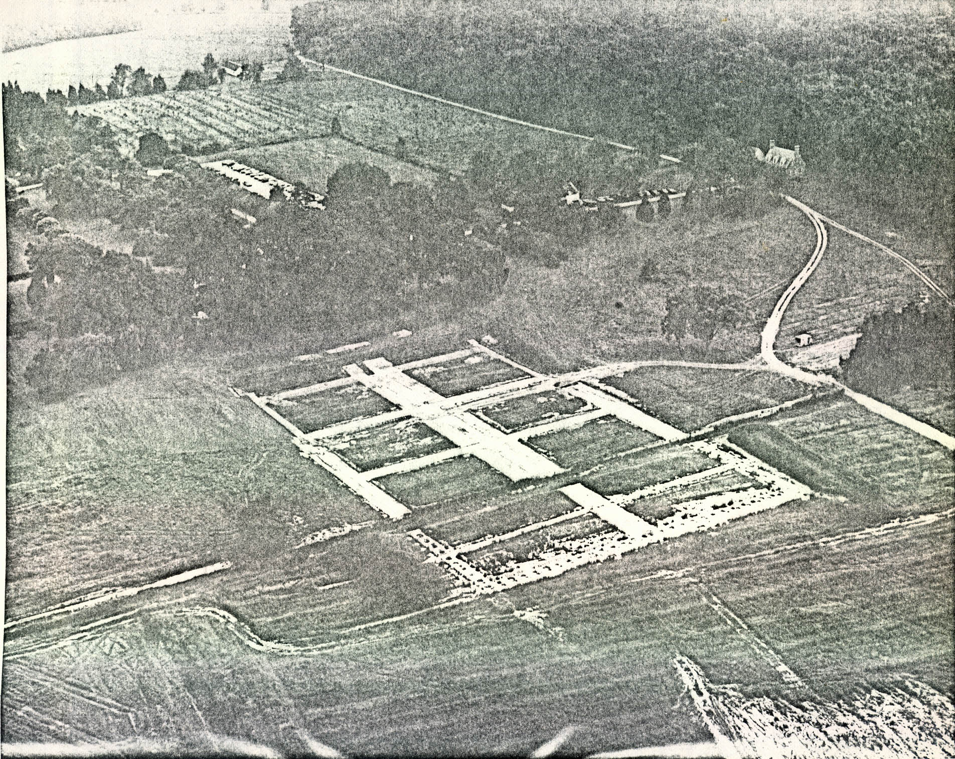 FIGURE 5 — Sketch Plan of the Garden (See Plate I and Fig. 28)
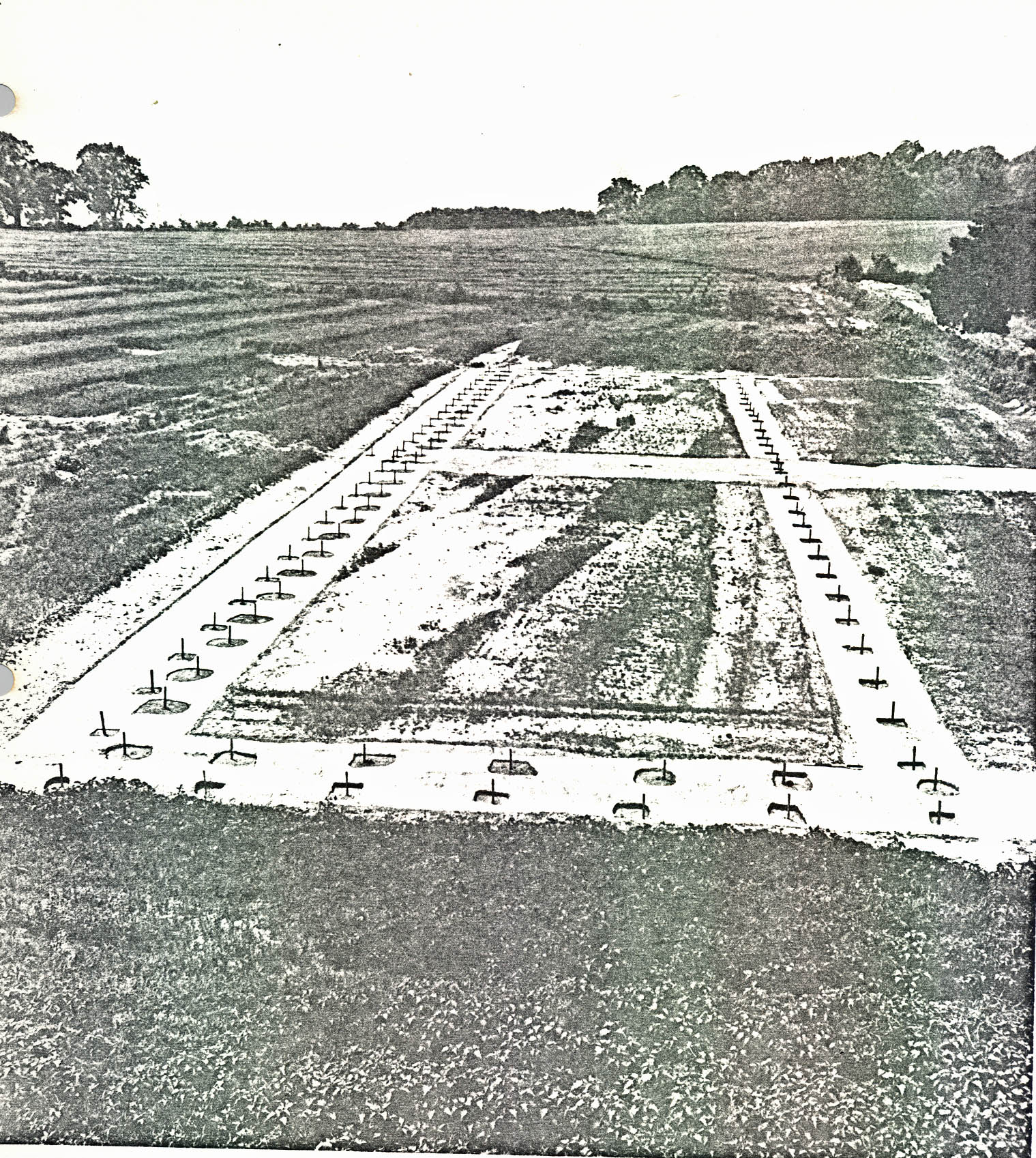 Plate I. — Aerial view of Carter's Grove garden during excavation showing the path system cleared and the south paddock fenceline excavated (foreground). See also Fig. 5 and Fig. 28 and Plate II. Photo from the southwest (71 F D 806)
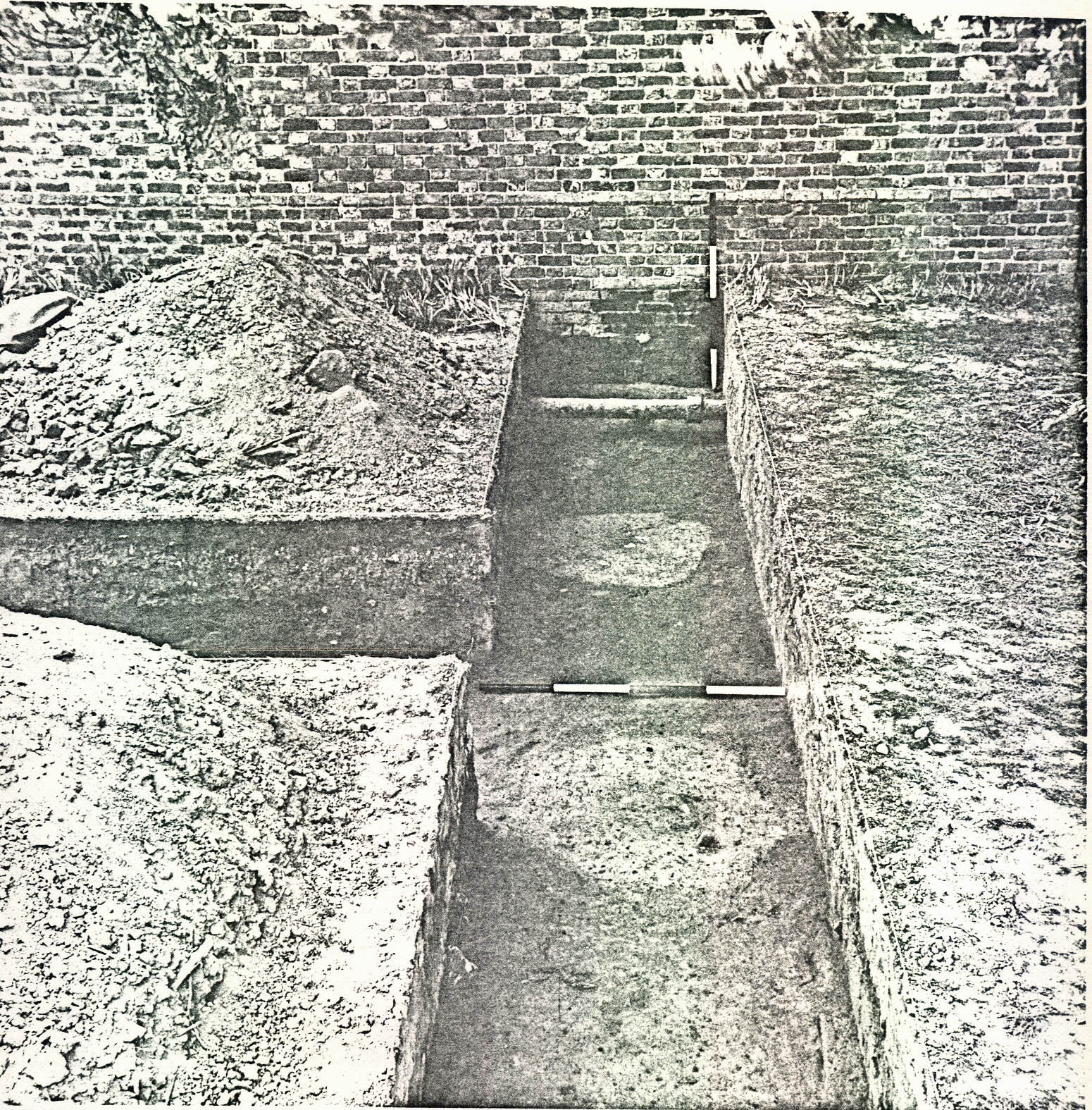 Plate II. View from the east of south paddock area garden fence postholes before excavation. (See also Fig. 28 foldout, rear jacket). (72 INH 895)
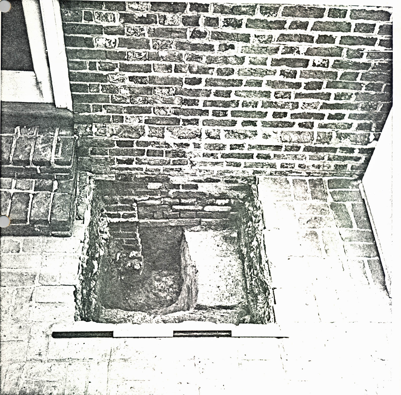 Plate III. View facing east of first and second period garden fenceline postholes before excavation. Note alignment with original corner of eighteenth century office building (background). (See also Fig. 28 foldout rear jacket). (72 INH 895)
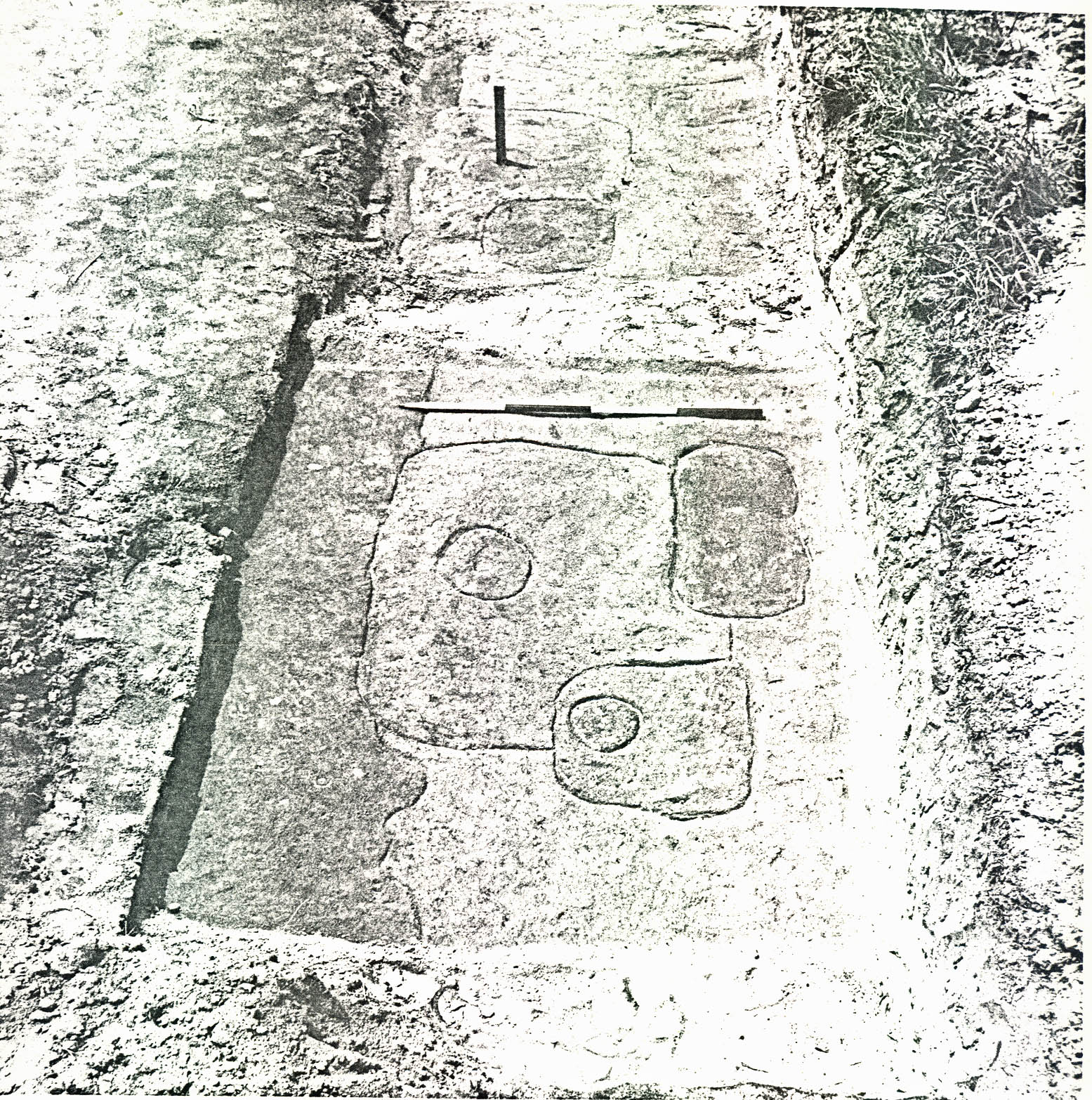 Plate IV. View from the east of trench CG 1592 showing first and second period garden fenceline postholes after excavation. Note alignment of postholes with south corner of eighteenth century kitchen. (See also Fig. 28 foldout rear jacket.) (72 INH 897)
The "sunken yard", front field area, was, in turn, subdivided into rectangular plots by the placement of a central path, side paths, cross paths, and an east-west intermediate fence 52'0" from the main south fenceline. Also, the central path extended up the terrace, where it became a ramp, and then across the "south front yard" to the main entrance to the mansion where it became a narrow shell walkway. Apparently a gate had been located at the extreme south end of the central path, and evidence for similar openings were found at the center of the intermediate fence — each end of at least one cross path, and possibly adjacent to each mansion outbuildings. Finally, planting ditches were found just outside of an parallel to the main south fenceline.
Two distinctly different sets of fence postholes were found where the main enclosure fence had been, and a third set of postholes was found in sections of the main west enclosure line.
a. First Period Fenceline
The earliest or first period fence apparently had been the most substantial. The extremely large postholes (See Plate V) ranged from 3'10" x 4'0", 4'7" deep, to 3'0" x 3', 21" deep, and averaged 3'3" x 3'3", 2'6" deep; and the post molds, some still retaining parts of the posts, ranged from 6" to 1'0" in diameter. The postholes at the corners were 3'6" x 3'8" deep, compared to an average depth of about 2'6" for the holes in between. Most of the first period posts had been set on 9'3" centers on the average with a few exceptions; i.e., gatepost locations (see below), and along each
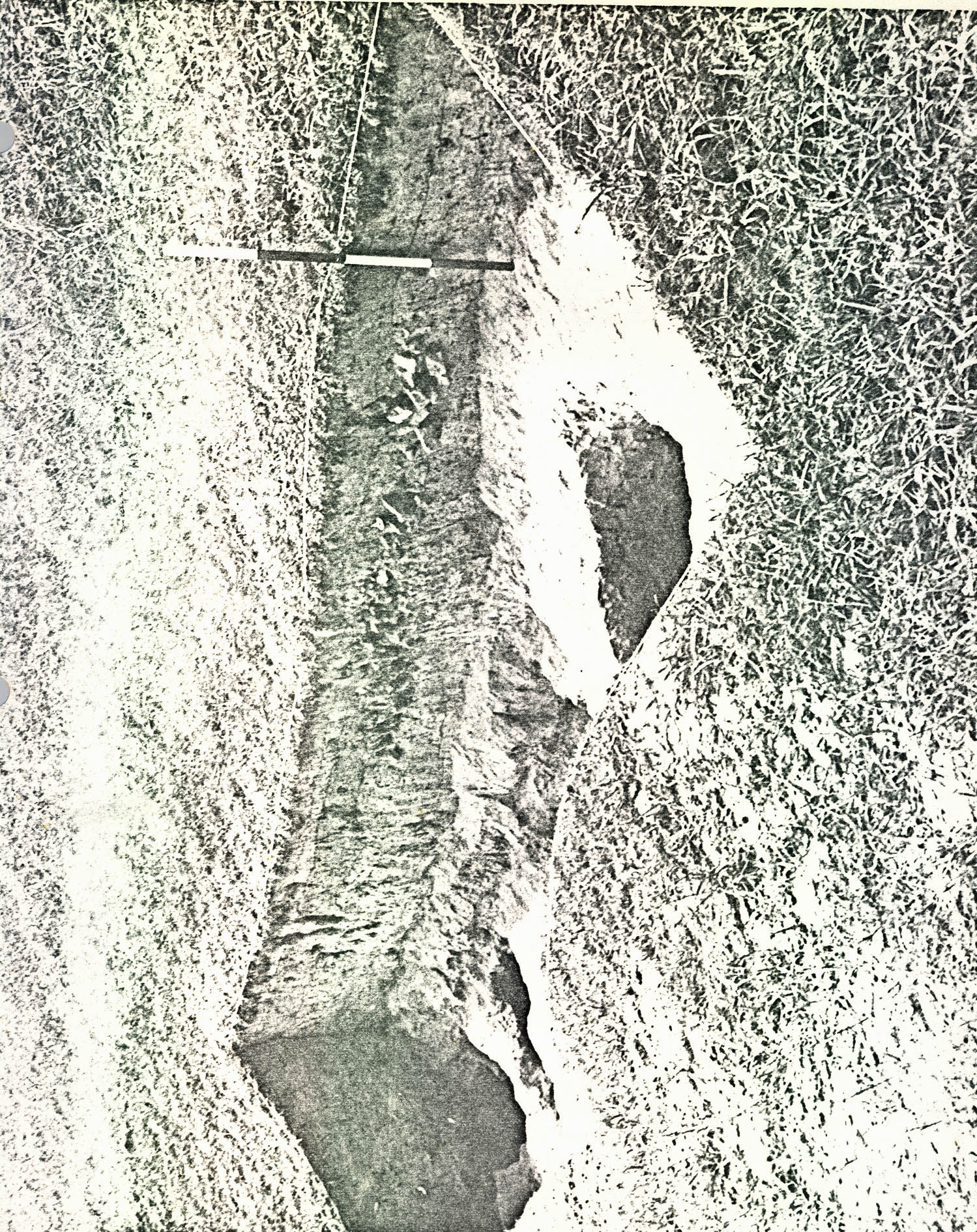 Plate V. View from the north of feature CG 1539 showing second and third period garden fenceline postholes cutting into first period garden fenceline postholes cutting into first period posthole. (See also Fig. 28 foldout rear jacket). (72 INH 898)
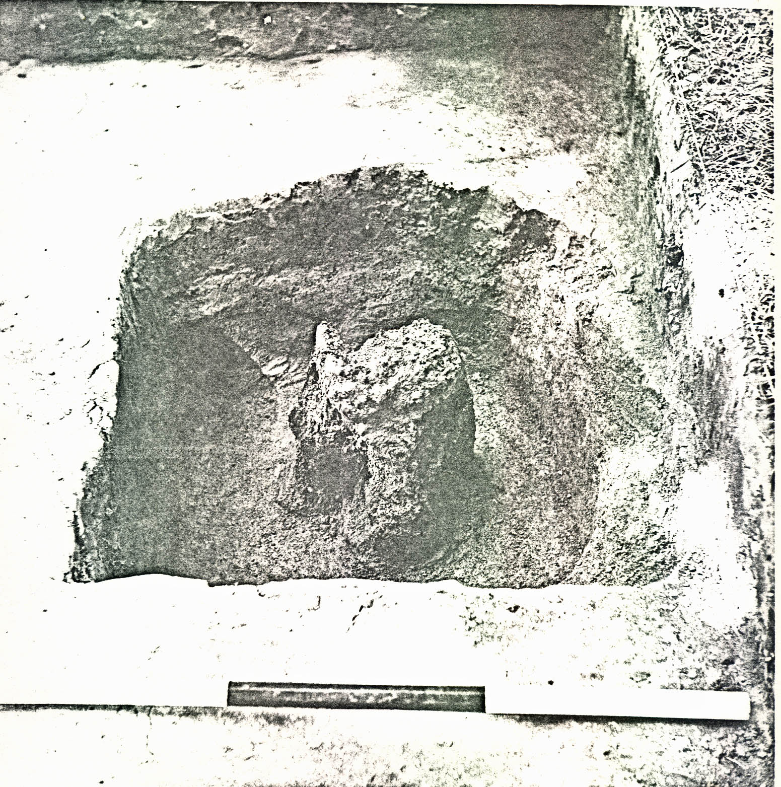 Plate VI. View from the northeast of trenches CG 1596, CG 1555, showing first and second period garden fenceline postholes cut into original grade of terrace flank and north-south crosse section through trash layers that had been deposited over and around the fenceposts (CG 1555M, CG 1596F) below the brick rubble. (See also Fig. 28 foldout rear jacket) (72 INH 904)
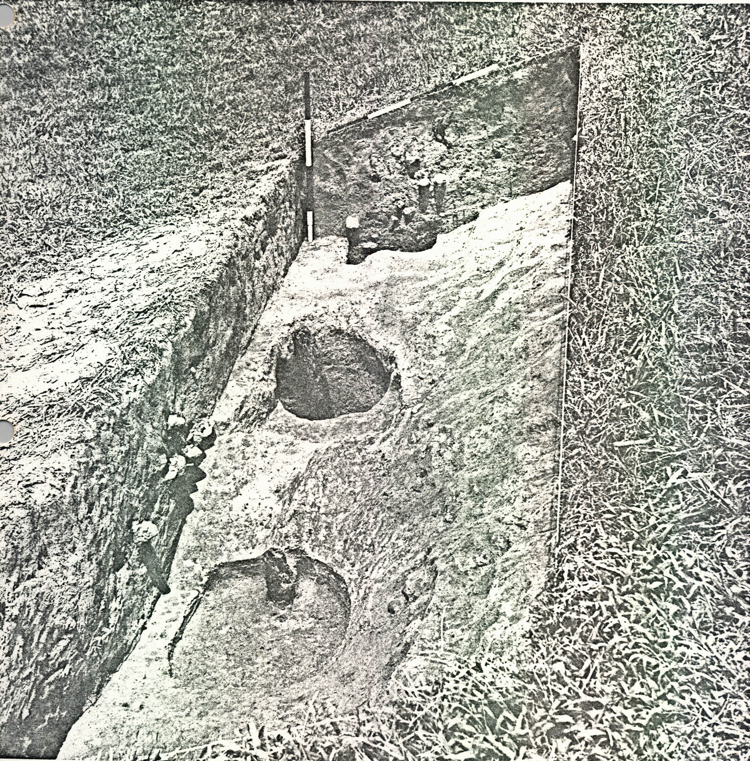 Plate VII. View from the south of trench CG 1540 showing partially excavated second period garden fence posthole (CG 1540C) with 8" diameter roughly finished post in situ
. (See also Fig. 28 foldout rear jacket) (72 INH 900)
Plate VII. View from the south of trench CG 1540 showing partially excavated second period garden fence posthole (CG 1540C) with 8" diameter roughly finished post in situ
. (See also Fig. 28 foldout rear jacket) (72 INH 900)
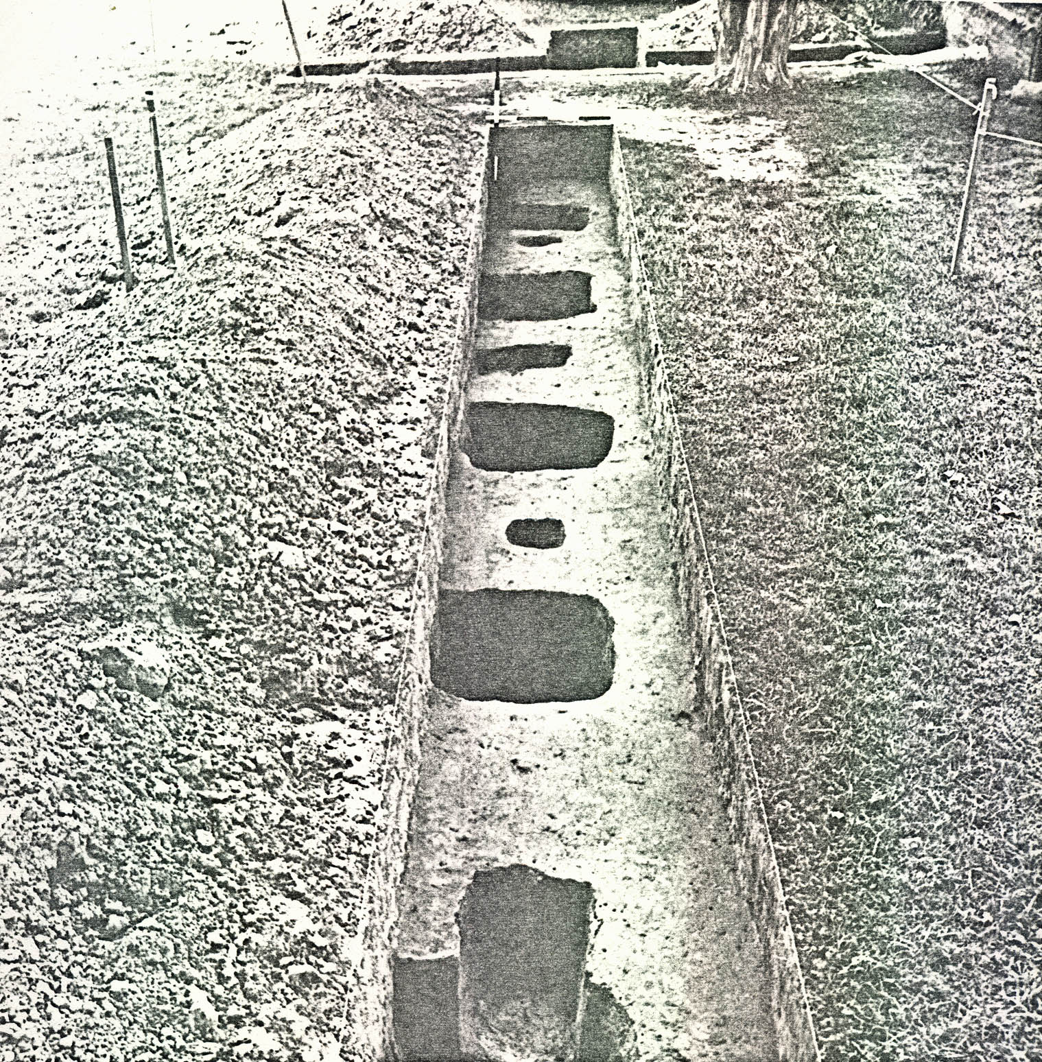 Plate VIII. View from the south of trench CG 1525 showing first and second period garden fenceline postholes as they ascend the first tier of the terrace. Note wooden posts in situ
. (See also Fig. 28 foldout rear jacket.) (72 INH 899)
11.
side of the terrace where some holes were as close as 4'0" (See Plate VI). Surviving sections indicate that the posts had been made of cedar and were left, at least below ground, in a rough, unfinished state. (See Plate VII)
Plate VIII. View from the south of trench CG 1525 showing first and second period garden fenceline postholes as they ascend the first tier of the terrace. Note wooden posts in situ
. (See also Fig. 28 foldout rear jacket.) (72 INH 899)
11.
side of the terrace where some holes were as close as 4'0" (See Plate VI). Surviving sections indicate that the posts had been made of cedar and were left, at least below ground, in a rough, unfinished state. (See Plate VII)
The archaeological evidence points to a post-1740 date for the construction of the first period fence; i.e., the backfilling of the postholes. Artifacts recovered from the postholes consisted primarily of wine bottle glass (CG 1353A, 1496A, 1497B, 1602A, 1596Q, 1596K) and pipe bowls (CG 1353A, CG 1550) made no earlier than 1740, and a vast quantity of artifacts found in trash layers sealing the postholes along the west terrace flank (CG 1555P, CG 1596F) also indicates a post-1740 installation-use date. A wine bottle neck (CG 1498A) found in a first period post mold (presumably having fallen into the cavity after the post rotted or was removed) suggests that the first fenceline was abandoned during the period 1760-1780.
b. Second Period Fenceline
Postholes for a second period fenceline were also found (See Plate VIII). They were smaller and not as deep as the first period holes, perhaps indicating that the second fence was less substantial. The holes ranged in size from 1'7" x 1'8" to 2'0" x 2'6" averaging 2'0" x 2'0" 1'1" deep. The post molds averaged 9" x 9" and were placed on 9'0" centers. The second fence generally followed the same line as the first on the west side and northwest return, but from the southwest corner to about the middle of the east line, the smaller postholes gradually moved outside (to the south 12. and east) of the earlier post line. However, the sections of the east line excavated on the east terrace flank, in the south front yard, and next to the kitchen wing of the mansion indicated that both periods of postholes had merged into the same line.
There is no doubt that the smaller holes were dug and filled after the larger holes, because, in many cases, the small holes actually cut into the fill of the larger holes (e.g., CG 1433, CG 1539) (See Plate VIII). How much time elapsed between the two periods, however, is almost impossible to determine. Sherds of creamware, a ceramic type apparently not used in Virginia until after 1769, were found in a second period posthole (CG 1536D). This suggests that the second period fence was installed sometime after 1769, perhaps two decades after the installation of the first period line. Moreover, common sense suggests that one would not make the effort to put in approximately 160 postholes and posts a second time unless the first fence had deteriorated to the point that it had ceased to function. In fact, the first fence must have been gone entirely on the west line, where both periods were dug on the same line. On the south and most of the east line, however, the earlier fence may have still been in existence during the second fence installation, necessitating the placement of the second period line outside of the first. Also, a ten to twenty year lifespan for the first fence does not seem unlikely in the Virginia climate.
13.Apparently the second fence, in turn, was abandoned in the first quarter of the nineteenth century. A trash spread (CG 1536B, CG 1536C) found sealing a second period post and mold was found southeast of the kitchen and contained artifacts made after about 1835.
c. Intermediate Fenceline
An intermediate fenceline, forming a 55' 0" x 245' 0" enclosure at the south end of the garden, was also located (See Plate II). The posthole size, averaging 2" x 2", 10" deep, the hole spacing (9'0" centers), and the alignment with the second period posts at each end suggest that this enclosure was added to the plan at the same time or after the second period fenceline. No datable artifacts were found in association with this fenceline.
d. Third Period Fenceline
A third period fenceline was also found, but only along the north half of the main west line (See Plate IX). These holes varied in size from 1' 2" x 1' 2", 2' 4" deep, to 2' 0" x 3' 0", 2' 10" deep, had molds 8" in diameter on the average, and were spaced on an average of 9' 9" between centers. In some cases, these postholes cut into the first period postholes, clearly indicating that they were dug later. However, no datable artifacts were found in the third period posthole fill; therefore, it is impossible to determine when this last fence had been installed. The third period line is also problematic in that it did not appear to join into the office wing of the mansion, nor did the postholes show up near the southwest edge of the terrace. For this reason, one could speculate that the third line was installed only where sections of the
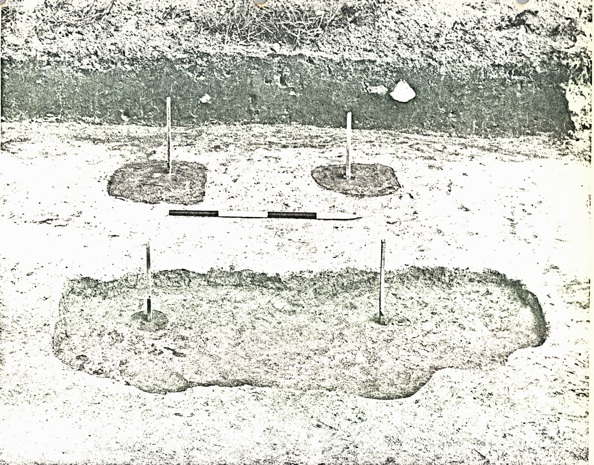 Plate IX. View from the south of trench CG 1553, CG 1586-89 showing three periods of garden fenceline postholes after excavation. (See also Fig. 28 foldout rear jacket.) (72 INH 901)
14.
line was installed only where sections of the second period fence had deteriorated.
Plate IX. View from the south of trench CG 1553, CG 1586-89 showing three periods of garden fenceline postholes after excavation. (See also Fig. 28 foldout rear jacket.) (72 INH 901)
14.
line was installed only where sections of the second period fence had deteriorated.
e. Gates
Five, and possibly six, gate locations, indicated by abrupt changes in the fenceline posthole spacing, were found. The central gate on the south fenceline had posts on 4' 6" centers in the first period fenceline and posts on 3' 6" centers in the second period fenceline. Moreover, the easternmost first period gate posthole (CG 1360) was 4' 11" x 3' 0", had been dug to a depth of 3'0" BNG, and had a 9" diameter post mold. Perhaps the increased dimensions indicate that this hole supported the pivot post for a heavy gate. However, if the size and depth of the holes do indicate a heavy gate, then the second period central gate must have been much smaller. The later postholes (CG 1409, CG 1462) were only 1' 4" x 1' 7". Also, the second period central gate included a third posthole located 3' 6" south of the fenceline, probably having supported a 6" diameter post for a gate weight.
Both periods of fences had gates at the east end of Crosspath 1 (See Plate X). The first period gate at that location had 9" diameter post molds, 4' 9" apart, set in one large posthole 5' 0" x 9' 0", while the second period gate had 9" diameter postmolds, 4' 6" apart, set in separate holes. The hole spacing at the west end of Crosspath 1, 5' 6", suggests that a gate existed there, but only during the life of the
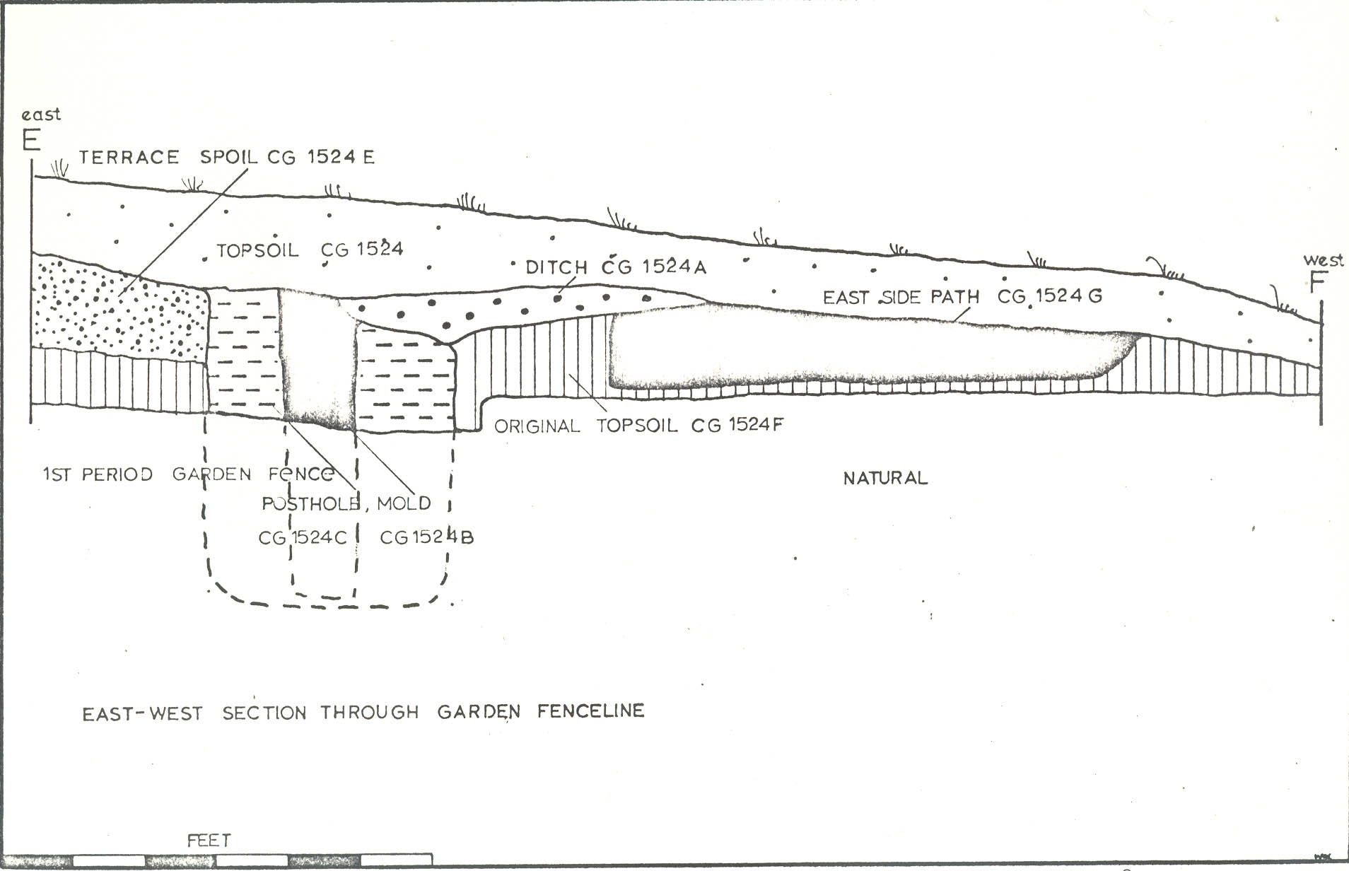 Plate X. View from the west showing first (CG 1492-93) and second (CG 1479-80) period garden fenceline gate postholes. (See also Fig. 28 foldout rear jacket.) (72 INH 902)
15.
second period fence. The larger, earlier holes remained on the standard 9' 3" centers. The hole spacing of 3' 6" also suggests that a gate existed at the center of the intermediate fence.
Additional gates may have been located next to each of the mansion outbuildings. The hole spacing diminished to 7' 0" next to the west wall of the office and next to the east kitchen wall, perhaps indicating that a wide gate had stood there.
Plate X. View from the west showing first (CG 1492-93) and second (CG 1479-80) period garden fenceline gate postholes. (See also Fig. 28 foldout rear jacket.) (72 INH 902)
15.
second period fence. The larger, earlier holes remained on the standard 9' 3" centers. The hole spacing of 3' 6" also suggests that a gate existed at the center of the intermediate fence.
Additional gates may have been located next to each of the mansion outbuildings. The hole spacing diminished to 7' 0" next to the west wall of the office and next to the east kitchen wall, perhaps indicating that a wide gate had stood there.
f. Path System
The area to the south of the terrace enclosed by the main fence system was divided into at least four equal rectangular garden plots (each approximately 100' 0" x 75' 0") by the installation of a system of sand paths. The central path, l' 1" wide, ran 344' 0" from the main south fenceline gate to the foot of the terrace and from there 107' 0" up an 11° - 17° sloping ramp, finally becoming a 6'0" wide crushed shell path running across the south front yard toward the door of the mansion. Paths 6' 0" to 8' 0" wide were also placed along the inside of the east and west fenceline running from the south intermediate fenceline up to and across in front of the base of the terrace. In addition, at least two east-west crosspaths 10'0" wide were placed at about 75' 0" intervals, connecting the central path with the sidepaths.
16.The first period central gate postholes cut through the sand fill in the central path indicating that the central path pre-dated the fence system. The central path may have also extended out into the field beyond the south fenceline suggested by a 14' 0" gap in the two outside planting(?) ditches (See below).
The path system had been constructed by either leaving some of the natural sand strata undug between garden plots (See below ) inside the flanks of the terrace or by digging trenches and filling them with sand (See Figure 6).
g. Garden Plots
One of the aforementioned rectangular plots, located just south of the terrace, was excavated, showing that the natural sand subsoil had been dug out to a depth of 2' 0" and subsequently filled with a rich brown sandy loam suitable for planting. Also, near the terrace, strips of natural sand were left between the plots to serve as the base for the paths. It is reasonable to assume, but not assured, that the other plots were similarly excavated and prepared for cultivation.
The 105' 0" x 256' 0" area at the south end of the enclosed area was stripped of the modern plow zone, revealing scattered areas filled with the same type of rich brown soil found in the plots, but mostly revealing only the sterile white sandy subsoil (See Plate II). No clearly defined plots or planting areas were found. The intermediate fenceline suggests that most of this area had been used for a paddock.
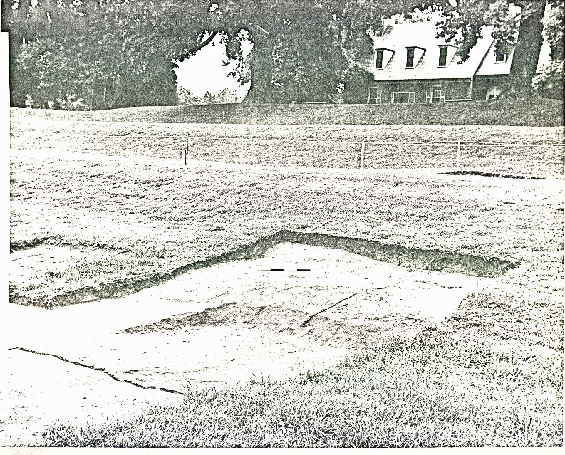 FIGURE 6 — EAST-WEST SECTION THROUGH GARDEN FENCELINE
Note: See Figure 28 for location.
h. Ditches
Three sets of what appeared to be planting ditches were also found in association with the enclosed area: two 2' 7" wide, 10" deep, 115' 0" - 120' 0" long features (CG 1517, CG 1518), running parallel to and outside of the main south fenceline; two 2' 0" wide, 1' 3" deep, about 176' 0" long ditches on the central path (CG 1590, CG 1593); and, three 5' 0" wide shallow ditches running parallel to and between the east and west fencelines and sidepaths.
Although no planting holes as such were found within the 5' 0" excavated sections of the south fenceline ditches, their plan suggests that they had been dug for planting purposes and not for drainage. Both features ended abruptly at the corner of the main south fenceline and just south of the end of the central path, rendering them useless for drainage. on the other hand, the ditches along the central section of the east and west fencelines could have been used for planting or drainage. Not enough of their profile survived modern plowing to be sure of their purpose. The two ditches on the central path, however, contained distinct planting holes toward the bottom. The sections of these two ditches that were excavated (CG 1590, CG 1593) showed a series of planting holes spaced 2' 0" - 4' 0" apart. However, a nineteenth-century fragment of bottle glass (CG 1593B) found in one of these planting holes suggests that these features were not part of the original eighteenth-century garden plan.
i. Terrace Ramp
As mentioned above, the central path led through the garden to the base of the terrace where it became a sloping ramp. The ramp was tested archaeologically for a distance of 84'0" (See Plate XI). A photograph of 1907-1910 (See Plate XII) shows that the ramp was in use in modern times. An east-west area, 42'0" in length, was also tested on the terrace, and this digging revealed planting holes (CG 1542D, CG 1554B) about 8'0" east and west of the edge of the ramp. The holes, about 2'11" in diameter, 1'2" - 1'6" deep, were backfilled sometime after the second quarter of the eighteenth century (CG 1542D) and after 1785 (CG 1554B). In modern times, perhaps during the renovation work carried out by the McCreas,12 the ramp was filled in and shaped to match the elevation of the terrace tiers.
j. Terrace
Machine test trenches dug into the terrace and the flanking topography showed that a tremendous amount of soil was quarried out of the original hillside to create the terrace, its flanks, and the lower level field between the terrace flanks. In all probability, the spoil from the original excavation was deposited on each flank to create a knoll on the west and a gradual slope on the east. Artifacts found beneath the spoil on the west terrace flank date this operation to c. 1740-1760 (See page 29). Also, spoil heaps located at the base of each terrace
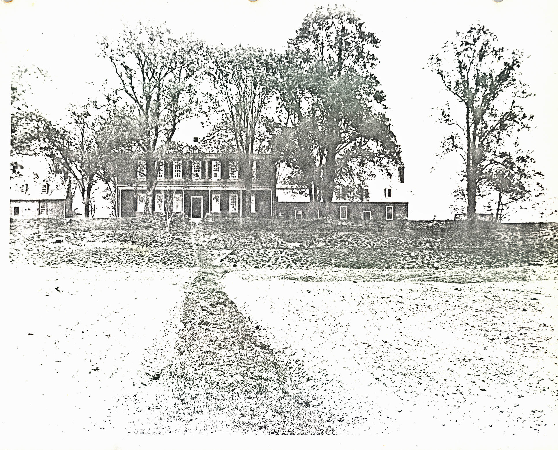 Plate XI. View from the southeast showing terrace ramp (center) original terrace grade and curb (?) (right center) and junction of central garden path with crosspath 3 (at base of terrace). (See also Fig. 28 foldout rear jacket.) (72 INH 903)
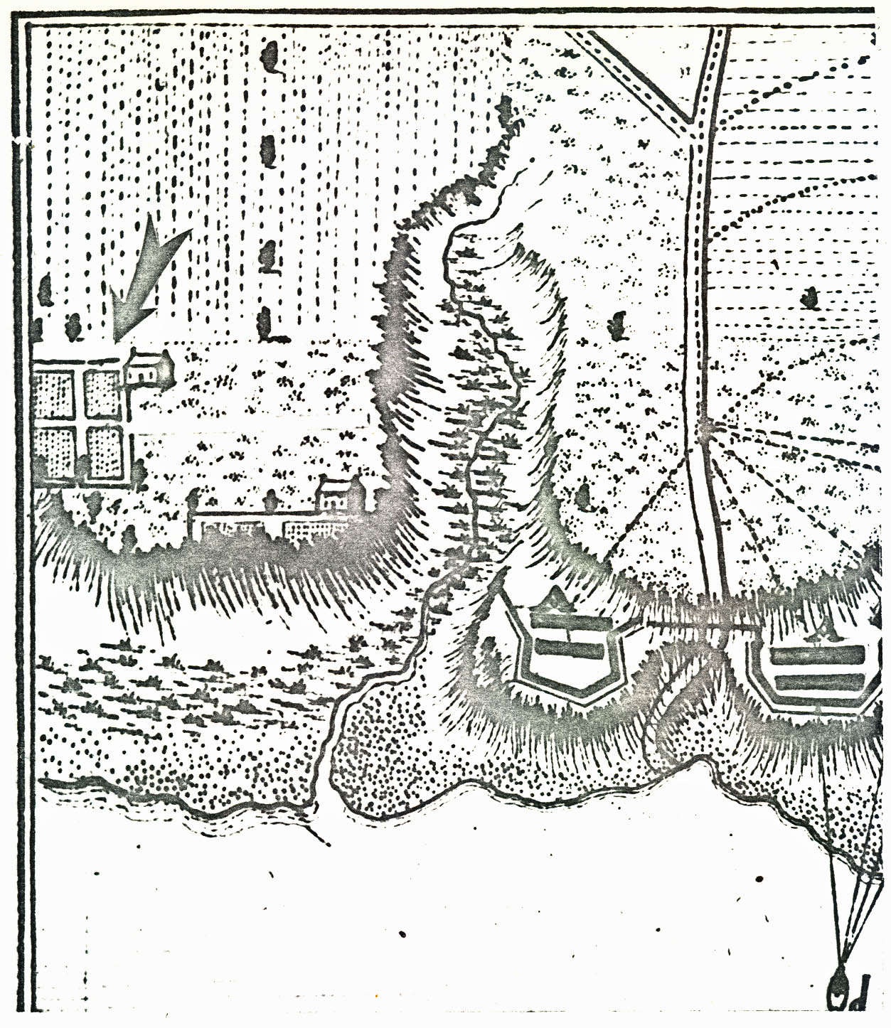 Plate XII. 1907-1910 photo from the south showing crude dirt terrace ramp still in use. (Valentine Museum, Cook Collection in Mary Stephenson, Carter's Grove Plantation, page 339).
19.
flank must have come from the quarrying (i.e., the orange sandy gravel fill matches the natural subsoil strata of the hillside).
Plate XII. 1907-1910 photo from the south showing crude dirt terrace ramp still in use. (Valentine Museum, Cook Collection in Mary Stephenson, Carter's Grove Plantation, page 339).
19.
flank must have come from the quarrying (i.e., the orange sandy gravel fill matches the natural subsoil strata of the hillside).
A test trench into the first two tiers of the terrace showed that the upper and middle tiers were made up of shaped natural subsoil, while the lowest step was formed partially of slightly mixed natural sand fill above graded natural subsoil. It could not be determined whether or not the actual tiers were put in when the original hillside was quarried or if they had been dug out later. However, it seems logical that both operations occurred at the same time.
There is little doubt that the main garden fenceline and garden paths were put in after the original hillside quarrying operation. In some sections of the fenceline (i.e., along the east and west lines), both periods of postholes cut through the aforementioned terrace spoil piles (CG 1471A, CG 1524E). Also, the east and west fencelines narrowed to 234' 0" apart east-west ostensibly to run along the base of the already existing terrace flanks, and some of the fenceline postholes showed up on the man-made grade of the terrace. Moreover, in some cases, layers of trash dating c.1740-1760 were found sealing the fill in the first period fenceline postholes as well as the shaped terrace flank grade (CG 1525E, CG 1555P, CG 1596F) (See Plate VI), suggesting that the creation of the terrace and the installation of the original garden fenceline occurred at 20. approximately the same time — after c.1740-1760.
k. The Historical Evidence
The historical record confirms the Carter's Grove garden archaeological evidence and dates its first period construction to 1765-66. In June 1765, Burwell's Ledger shows that "1500 Garden Pails [pales or pickets]" were purchased and in 1766 Peyton Randolph was paid for "840 fence Rails" and "921 Stakes."13 From this, there can be no doubt that a considerable amount of fence construction was being carried out at Carter's Grove in 1765-66 and that a huge garden was being enclosed by a pale or picket fence. Including the area between the original outbuildings flanking the mansion, the fenceline around the garden found by archaeology measures some 1400'0". It is reasonable to assume that 1500 pales would be needed to secure a fenceline of that length.14 Also, it may be that some of the 840 rails were used to support the pales, and perhaps some of the stakes were used as the rail supporting posts.
Another Burwell Ledger entry may be the key to a more precise installation date for the second period garden fenceline. In 1774, Burwell sold James Hubbard of Williamsburg 100 cedar garden posts. It could be that these posts were made at Carter's Grove during the reconstruction of the garden fenceline. Also, in 1781, Burwell planted three rows of trees outside the "garden".15 Symmetrical gardens of the Carter's Grove plan seem to be typical of Tidewater plantations along the James, at least those owned by the Burwell family. A 21. military map of 1781 (See Figure 7) shows that neighboring Kingsmill Plantation (owned by Colonel Lewis Burwell) had no less than two patterned gardens, one (near river) having been there long enough for the river to erode half of it away.16
Finally, the following description of a strikingly similar garden in Maryland, written about 1800, suggests that the Carter's Grove garden was probably partially decorative, partially utilitarian and perhaps typical of its period:
Md.—Mr. Pratt's [Ca.] 1800
Tuesday 15. The exercise much the same as yesterday — more intoxication.
Saturday 19th … Mr. Pratts garden for beauty & elegance exceeds all that I ever saw —It is 20 rods long — and 18 wide — An ally of 13 feet wide runs the length of the garden thro' the centre — Two others of 10 feet wide equally distant run parrallel with the main alley. These are intersected at right angles, by 4 other alleys of 8 feet wide — Another alley of 5 feet wide goes around the whole garden, leaving a border of 3 feet wide next to the pales — This lays the garden into 20 squares, each square has a border around it of 3 feet wide — Likewise the border of every square is decorated with pinks and a thousand other flowers, which is impossible for me to describe. The remaining part of each square, within the border, is planted with beans pease, cabbage, onions, Betes, carrots, Parsnips, Lettuce, Radishes, Strawberries, cucumbers, Potatoes, and many other articles —Without the pales stand a row of trees upon three sides of the garden — These consist of Pear, Peach, apple, cherry, & mulberry trees. Within the pales, on the out border, are planted, Quince, snoball, Laylock, and various other small trees, producing the most beautiful flowers—
The beauty, Taste, & elegance which attends it, is perfectly indescribable —
It is an enchanting prospect, and carries the spectator, into an extacy, which he cannot describe — The effluvia arising from the various flowers — sweetens the air.17
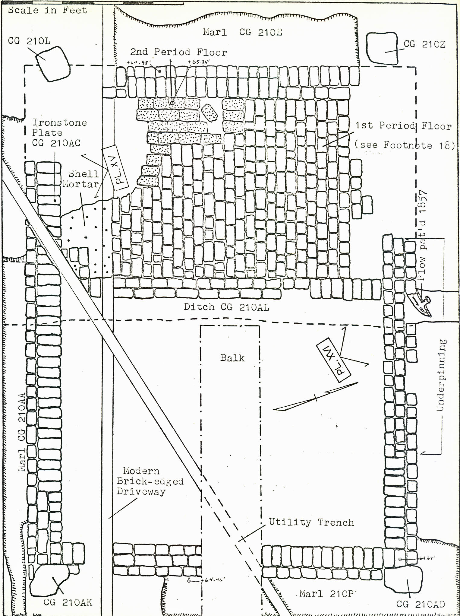 Figure 7 — Simcoe Map of 1781 showing gardens at Kingsmill Plantation (arrow) similar in plan to that found at Carter's Grove.
2. Dairy(?) Building
One relatively intact brick foundation was found 100' 0" northeast of the mansion (See Figure 1, Plates XIII and XIV). Overall, the footing measured 17' 0" x 13' 0" and was 11/2 bricks thick. The structure was divided into two rooms by a one-course brick footing (See Figure 8). The room on the east measured 8' 11' x 10' 9" on the interior, while the room on the west measured 6' 0" x 10' 9" and included two periods of brick floors. The lower or earliest brick floor in the west room was laid on a bed of shell mortar. Shell mortar was also found clinging to some of the bricks in the wall footing, but apparently these bricks had been reused from an earlier construction. With the exception of the west room floor, all of the brickwork associated with the structure had been bonded with a later type of mortar not containing bits of shell.
A considerable amount of brickbats was used in the wall construction, and brickbats alone were used in the central 7' 6" of the north wall (See Fig. 8), probably having been placed there during an underpinning operation. Apparently, the foundation sagged in that section because it had inadvertently been constructed on the fill of an earlier drainage ditch (CG 210AL).
A marl walkway or working surface was found on at least three sides of the structure (CG 210E, 210P, 210AC). However,
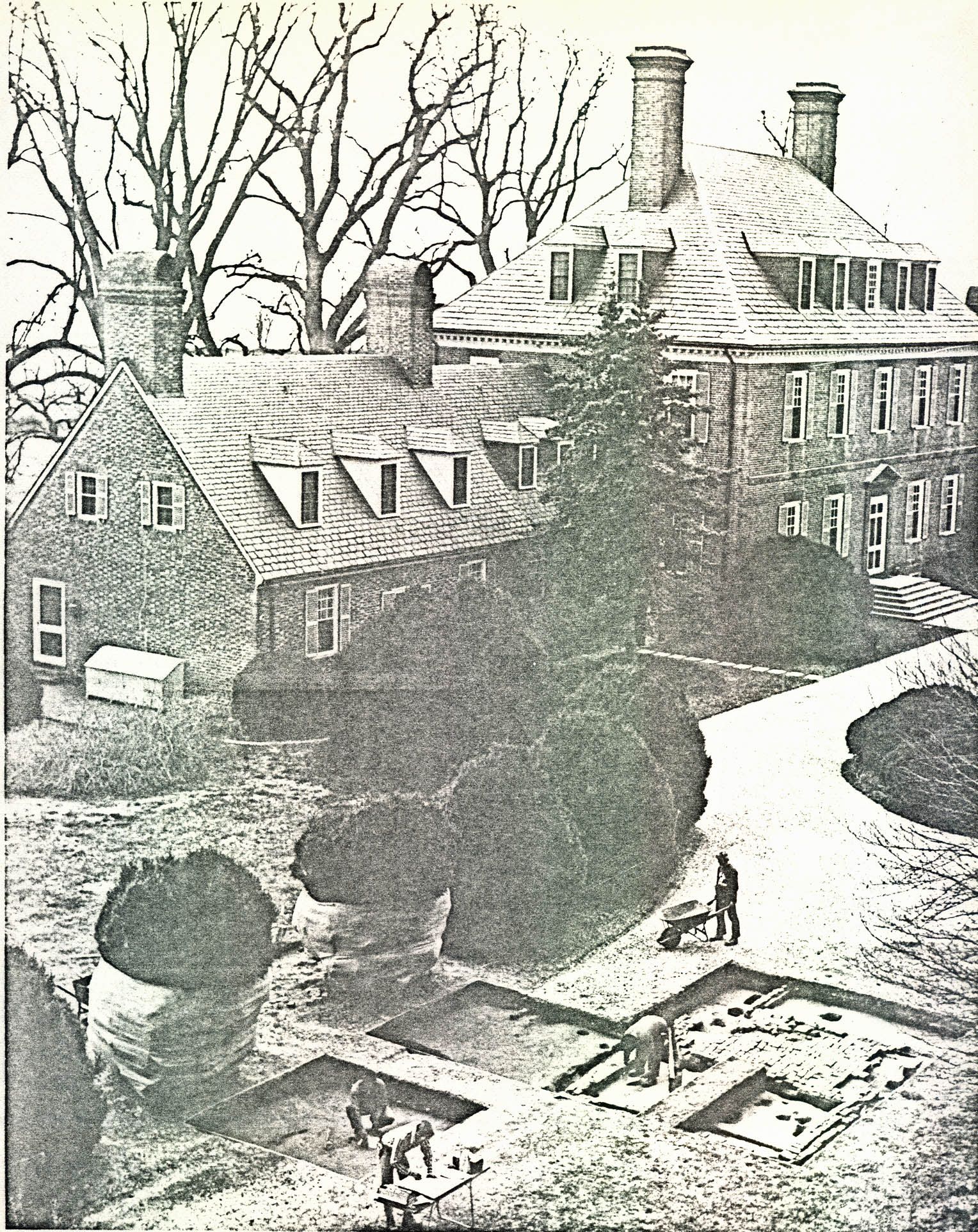 FIGURE 8 — Dairy (?) Building Plan (See Plates XIII and XIV and Fig. 25)
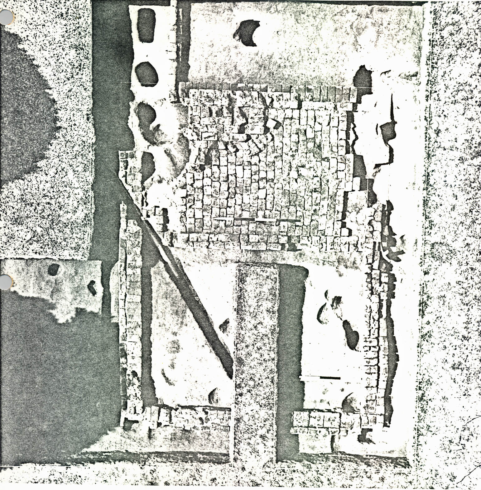 Plate XIII. — View from the northeast showing the relationship of the dairy (?) building foundation (right foreground) to the mansion (background). (See also Fig. 1 and Fig. 8) (72 INH 905)
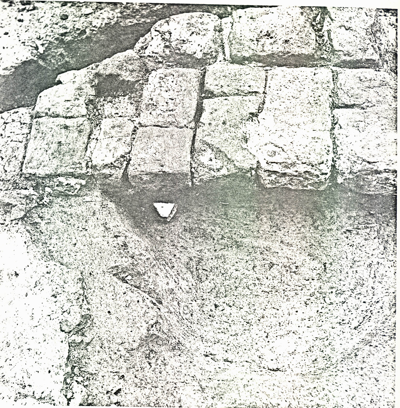 Plate XIV. — Overhead view of dairy (?) building foundation after excavation. (See also Fig. 8) (72 INH 906)
23.
the marl was not concentrated enough in one particular area to suggest doorway locations. Moreover, later disturbances had destroyed some of the marl layer as well as sections of the brickwork itself (i.e., the southwest corner and part of the floor of the west room, the northwest corner and more of the west room brick floor). Moreover, the brick curb of the modern east-west driveway to the mansion and a modern utility line cut through the east, south and west wall footings. Also, holes approximately 1' 0" x 1' 0" were found near each of the four corners of the structure (CG 210L, 210Z, 210Ad, 210AK), two of which (northeast and southeast) cut through the outer course of the brick foundation.
Plate XIV. — Overhead view of dairy (?) building foundation after excavation. (See also Fig. 8) (72 INH 906)
23.
the marl was not concentrated enough in one particular area to suggest doorway locations. Moreover, later disturbances had destroyed some of the marl layer as well as sections of the brickwork itself (i.e., the southwest corner and part of the floor of the west room, the northwest corner and more of the west room brick floor). Moreover, the brick curb of the modern east-west driveway to the mansion and a modern utility line cut through the east, south and west wall footings. Also, holes approximately 1' 0" x 1' 0" were found near each of the four corners of the structure (CG 210L, 210Z, 210Ad, 210AK), two of which (northeast and southeast) cut through the outer course of the brick foundation.
A sherd of an octagonal, blue shell-edged ironstone plate, c.1840-1860 (CG 210AC) (See Plate XV), was found in a backfilled hole beneath the south wall of the structure. Therefore, it is almost certain that the brickwork supporting the walls of the structure was laid after c.1840. There is no doubt that the brick underpinned section of the north wall was put in after 1857. An iron plowshare with "…WATT & CO. RICHD. VA. PAT 1857" (CG 210AY) (See Plate XVI) molded on it was found sealed beneath the brickwork. Finally, a layer of fill (CG 210A) sealing the brickwork and floors contained artifacts dating after c.1850. Therefore, it can be stated with unusual certainty from archaeological evidence that the brick foundation was built, used, repaired
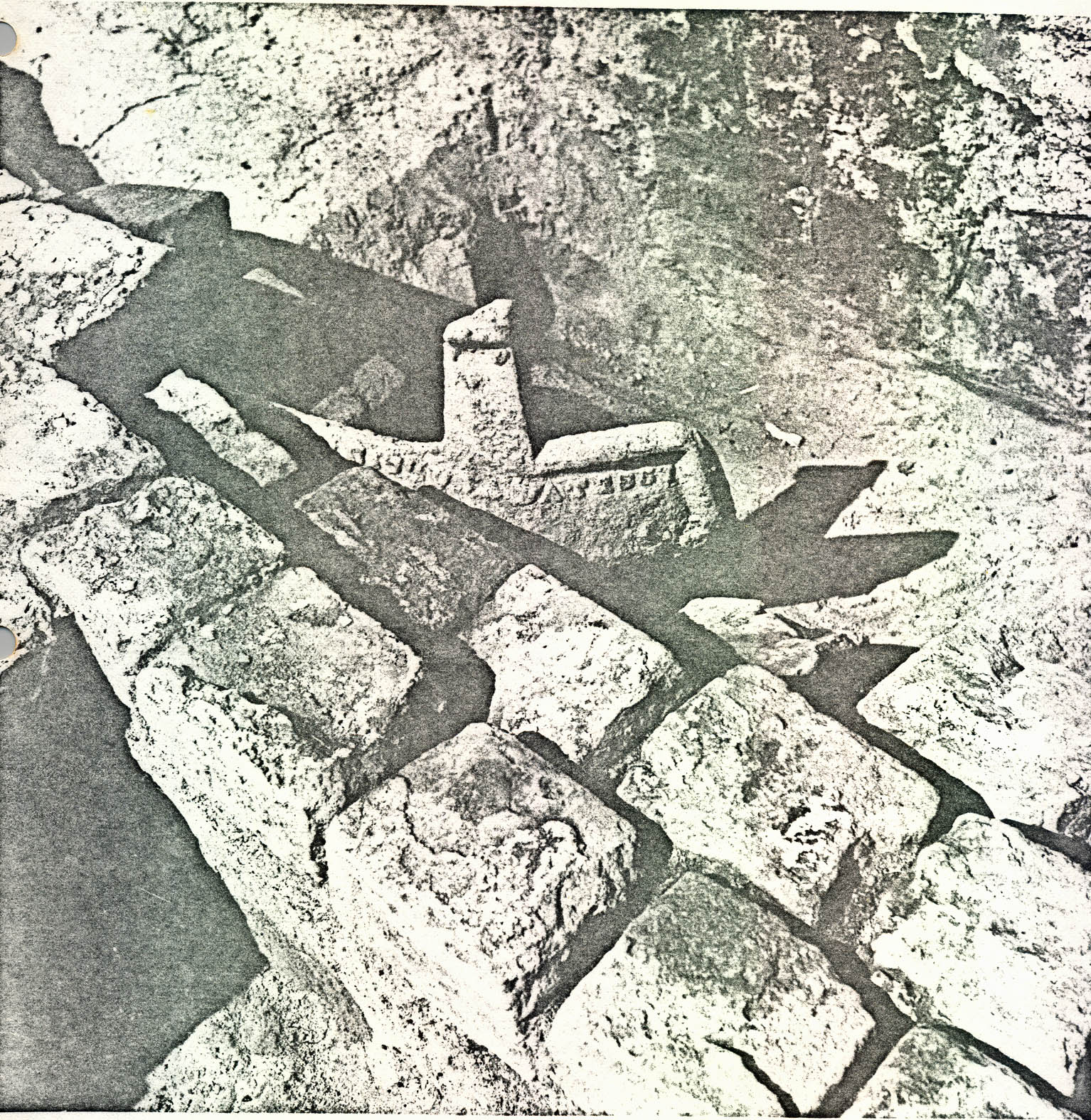 Plate XV. — View from the northwest of blue shell-edged octagonal ironstone plate sherd (CG 210AC) of the period 1840-60 in situ
beneath south foundation of dairy (?) building. Note edge of shell mortar bed for first period brick floor, west room (lower left). (See also Fig. 8). (72 INH 907)
Plate XV. — View from the northwest of blue shell-edged octagonal ironstone plate sherd (CG 210AC) of the period 1840-60 in situ
beneath south foundation of dairy (?) building. Note edge of shell mortar bed for first period brick floor, west room (lower left). (See also Fig. 8). (72 INH 907)
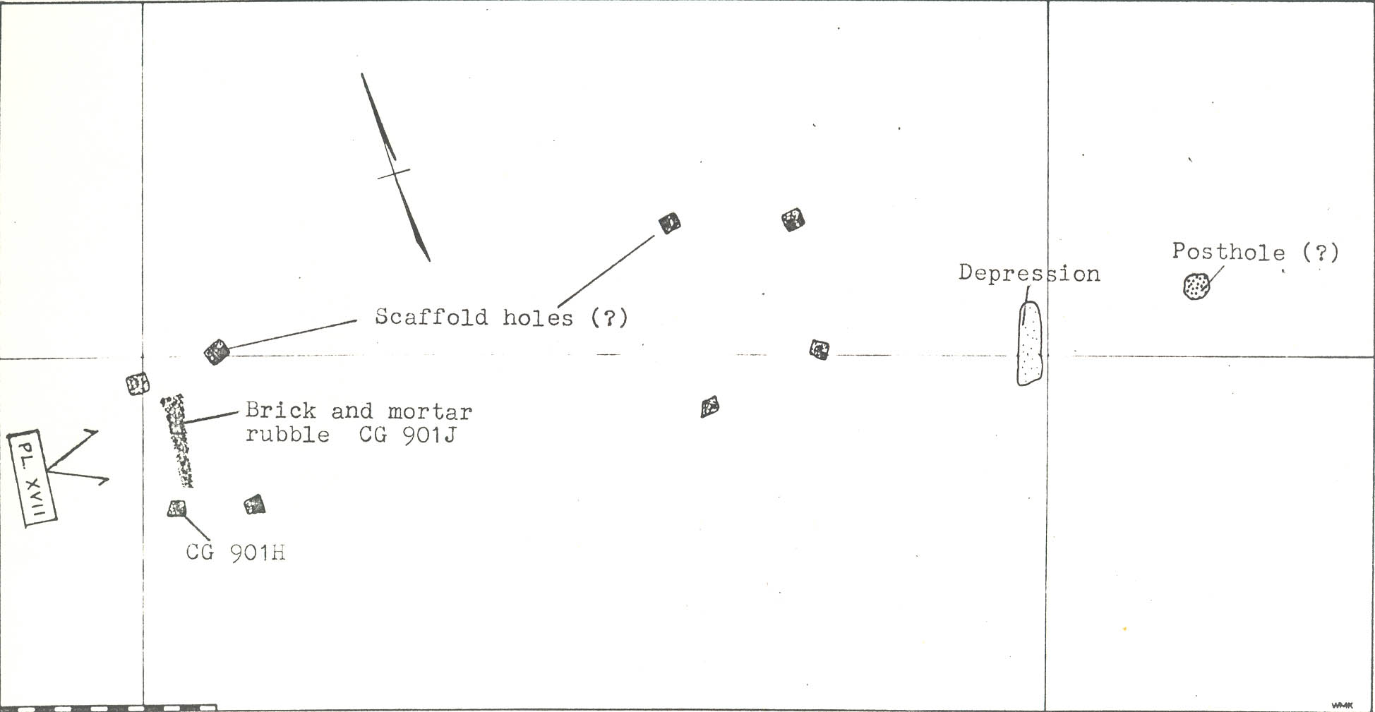 Plate XVI. — View from the southeast showing iron plow point with 1857 patent date (CG 210AY) sealed beneath brick underpin, north wall of dairy (?) building. (See also Fig. 8) (72 INH 908).
24.
and abandoned during the latter two-thirds of the nineteenth century.
Plate XVI. — View from the southeast showing iron plow point with 1857 patent date (CG 210AY) sealed beneath brick underpin, north wall of dairy (?) building. (See also Fig. 8) (72 INH 908).
24.
and abandoned during the latter two-thirds of the nineteenth century.
However, as mentioned above, the first period brick floor in the west room was laid on shell mortar — a mortar type found to have been used exclusively in the eighteenth century in Virginia. Therefore, it is possible that the first period floor had been first used inside an earlier (eighteenth-century) outbuilding that was either removed and replaced with a larger structure or jacked up and underpinned with brick after c.1840.
There is some historical evidence for dating the foundation. An 1875 plat of Carter's Grove (See Appendix IV) shows a rectangular structure roughly sketched in the general vicinity of the foundation located by archaeology. Archaeological testing in the exact plat location of the structure did not produce structural evidence. Therefore, it is reasonable to assume that the draftsman was only attempting to show the number and general locations of structures. This being the case, it follows that the building located by archaeology was still in existence in 1875. Moreover, a United States Army map of the property dated 1922 does not show any outbuildings in the area of the kitchen.
There is reason to believe that the structure was moved from the site and not razed. The holes at each corner (mentioned above) were probably dug to 25. position jacks beneath the sills as part of a moving operation. The fact that the northeast and southeast holes cut through and destroyed parts of the brick corners of the foundation tends to negate the possibility that the jacks were used for underpinning.
The insubstantial nature of the wall foundations of the building suggests that it supported a frame structure. Moreover, the brick floor in the west room and the dirt or wooden(?) floor in the east room suggest that the building was used for a dairy. Historical records show that a dairy existed at Carter's Grove as early as 1741-42, and perhaps it was this structure that stood over the shell mortar-based brick floor in the eighteenth century.
3. 1782 House Site
In the late fall of 1970, east-west machine cuts 7' 0" wide were made through the plow zone at 20' 0" intervals in Fields 4, 5 and 6 (Fold out Figure 26) in an attempt to find evidence of two structures and a road shown on the Desandrouin Map of 1782 (See Fig. 4). A concentration of ceramic sherds (CG 900) dating primarily in the second half of the eighteenth century and brick and shell mortar were found in the plow zone in the approximate location of the westernmost structure (1782 Map). Total striping of the plow zone in this section produced two sets of four shallow postholes and a concentration of brick and shell mortar chips 26. between the westernmost post holes (CG 901A, CG 901H) (See Figure 9 and Plate XVII). The holes, measuring about 1' 0" square and 6" deep, contained brickbats (4" x 2¼" x ?) which had been apparently packed around 6" x 6" posts. The two sets of holes were exactly 27' 0" apart and the pairs of holes at each end were both 7' 6" apart. However, the distance between the east and west pairs in each group varies from 6' 6" on the east to 4' 1" on the west.
The plowing had obliterated the stratigraphy of the area with the exception of the lower fill in the postholes and the brick and mortar spread. One clay tobacco pipe stem fragment (CG 901H) was the only artifact found in situ . Its stemhole diameter may show that it had been made in the third quarter of the eighteenth century, but one stem is hardly much dating evidence. The artifacts in the plow zone (CG 900) in the vicinity of the holes suggest that the structure had been occupied in the period c. 1725-1800, there being no later or earlier material recovered.
It is reasonable to conclude from the symmetrical arrangement of the postholes and the brick and mortar spread that these features are the remains of end chimneys probably having been attached to a frame rectangular structure 24' 0" x ?'. The holes themselves were probably dug to support scaffold poles used during the chimney construction,19 and the brick and mortar spread could well be
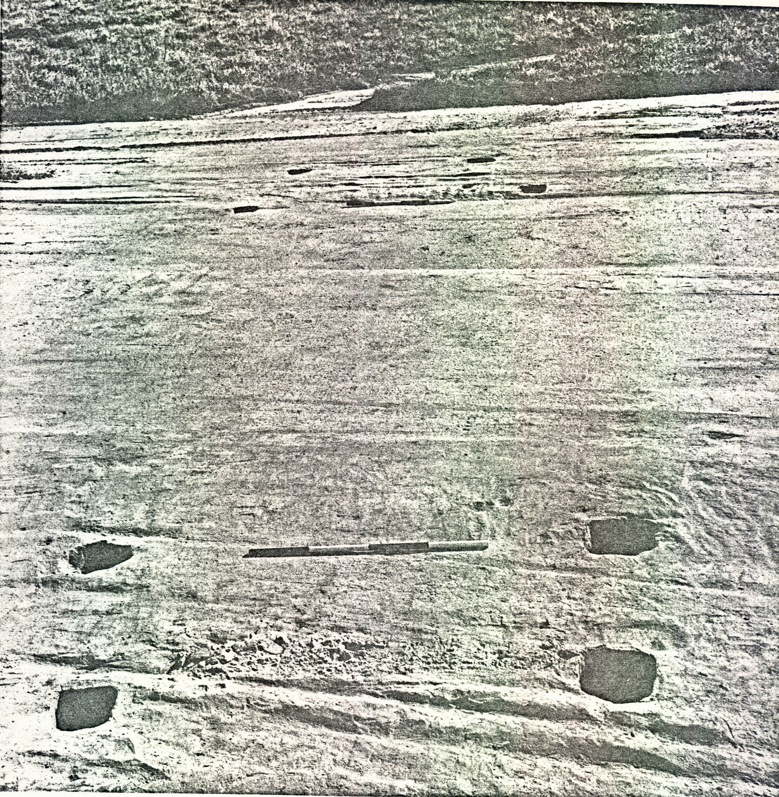 FIGURE 9 — Plan of 1782 House (?), Field 5.
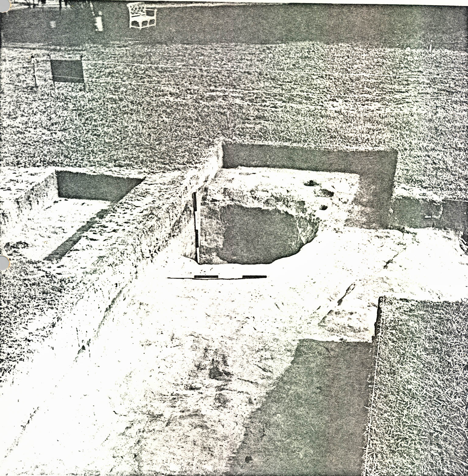 Plate XVII. — View form the west of eight postholes (scaffold holes) found in filed 5 at the approximate location of a rectangular structure shown on the Desandrouins Map of 1782. Note spread of brick rubble and mortar between holes in foreground, probably remains of the chimney foundation. (See also Fig. 9 for location. (72 INH 909)
27.
the remains of the west chimney base itself or construction or salvage debris. The hole spacing at each end suggests that the east chimney had been the largest, perhaps indicating an east "hall" — west "parlor" floor plan. No other structural evidence was found; therefore, the actual size and appearance of the structure is beyond the scope of archaeology. Furthermore, it should be added that without the 1782 map showing a rectangular structure at the posthole location, one would be on "shakey" archaeological ground to interpret these features as a building at all.
Plate XVII. — View form the west of eight postholes (scaffold holes) found in filed 5 at the approximate location of a rectangular structure shown on the Desandrouins Map of 1782. Note spread of brick rubble and mortar between holes in foreground, probably remains of the chimney foundation. (See also Fig. 9 for location. (72 INH 909)
27.
the remains of the west chimney base itself or construction or salvage debris. The hole spacing at each end suggests that the east chimney had been the largest, perhaps indicating an east "hall" — west "parlor" floor plan. No other structural evidence was found; therefore, the actual size and appearance of the structure is beyond the scope of archaeology. Furthermore, it should be added that without the 1782 map showing a rectangular structure at the posthole location, one would be on "shakey" archaeological ground to interpret these features as a building at all.
No substantial structural evidence was found at the 1782 map location of the easternmost structure (See Figure 4). A cluster of irregular holes (CG 924, CG 933) (See Figure 26), in no apparent structural order, was found in the general vicinity of the map location, but with the exception of a large gunflint (CG 933A) and handmade nails (CG 931A), no concentration of colonial artifacts was found. However, the 1782 map seems to show that the east structure had at least five sides to it, which may be indicating something as structurally irregular as a hog pen.
4. Icehouse Pit (?)
Test holes dug in the vicinity of the knoll immediately to the west of the terrace located an area of concentrated 28. colonial occupation and a buildup of sandy orange clay fill on the southern slope (Fold out Figure 24). Hoping to date the construction of the terrace and perhaps find colonial structural evidence, the test holes were expanded into an area excavation.
(a.) Pit A
A circular pit (Pit A), 6' 6" in diameter and 4' 8" deep, was found in the north end of the expanded trenches (See Figure 10 and Plate XVIII). The pit had been backfilled with: (1) an initial deposit of domestic trash (CG 460G); (2) clean brown sandy loam (CG 460F); (3) a layer of trash, woodash, and oystershell (CG 460D); and, (4) another layer of trash (CG 455B, CG 460A) below the topsoil (See Fig. 12). The artifacts and cross-mending suggest that this feature had been backfilled in the period 1750-60.
(b.) Pit B
Another pit (Pit B), about 5' in diameter but only 18" deep, was found 7' southeast of Pit A (See Fig. 11). It primarily contained a concentration of broken wine bottle glass, but occasional sherds of colonial ceramics were also found, some of which cross-mended with ceramics recovered in Pit A. Thus, both Pit A and Pit B were probably filled at the same time (c.1750-60) with material coming from the same place.
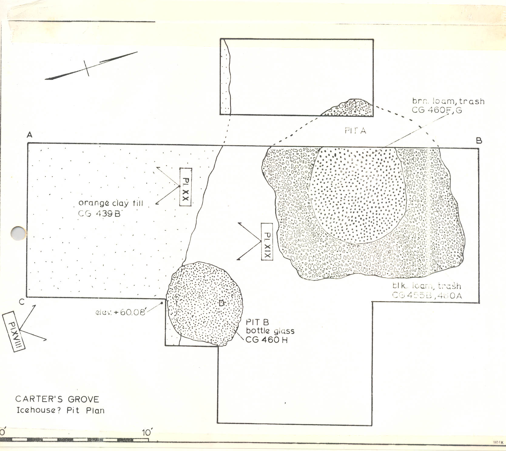 FIGURE 10
 MAP OF CARTER'S GROVE PLANTATION ON THE JAMES RIVER
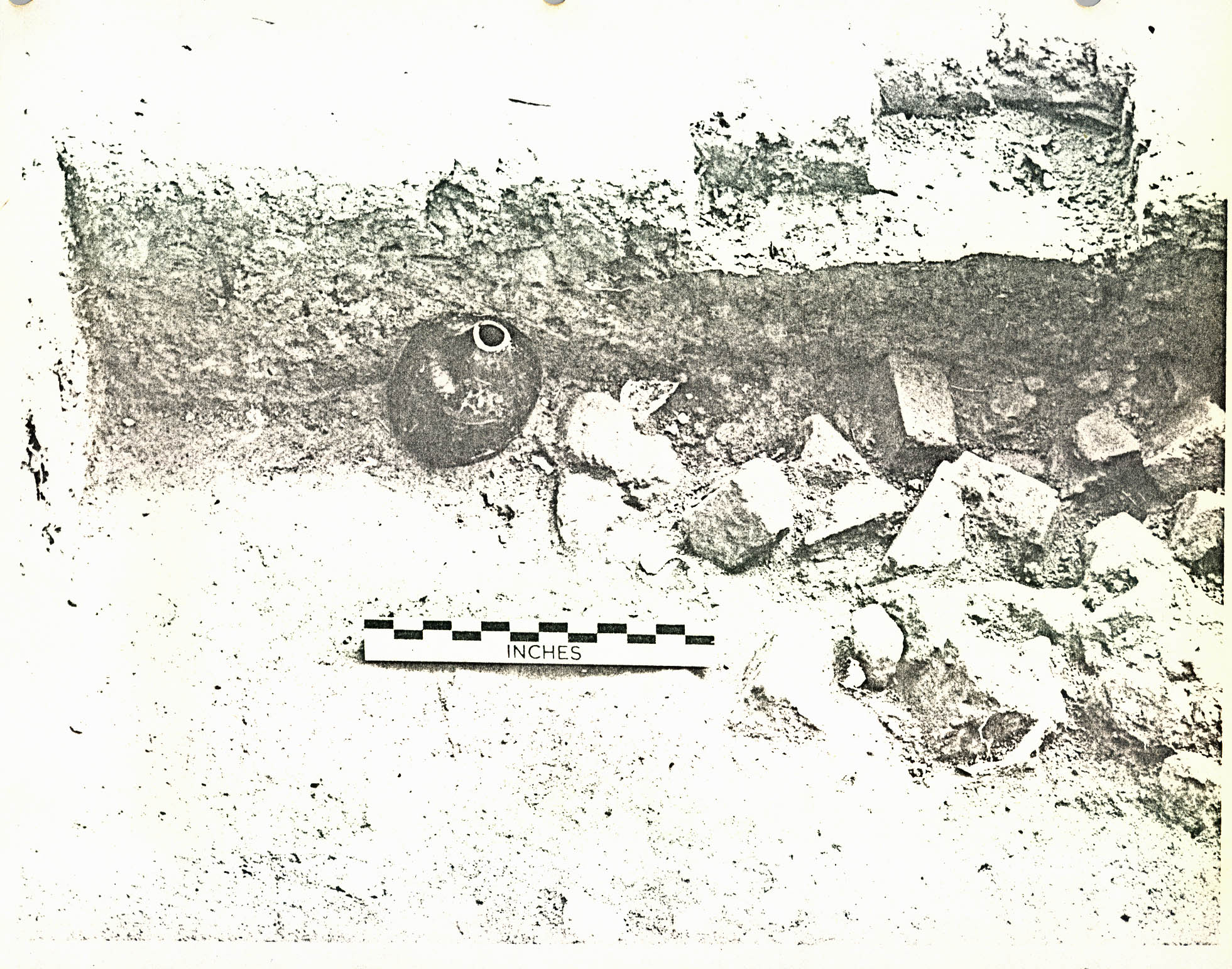 Plate XVIII. — View facing north of icehouse pit (?) Pit A (CG 460) on west terrace flank (background and cross-section (left) through sandy fill (CG 439B) from terrace construction (?). (See also Fig. 24 for location and Figs. 10 & 11.) (72 INH 910)
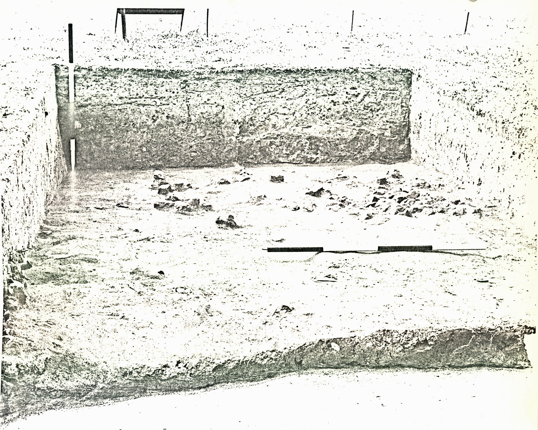
(c.) Terrace Fill
The fill in Pit B (CG 460H, CG 439F) had been deposited directly on top of the northern edge of orange clay fill (CG 439B) which, in turn, had been deposited on the natural slope of the hill to the south (See Figure 11). The orange clay itself had been deposited on a spread of brickbats (CG 439C) mixed with original topsoil (See Plate XIX). Wine bottles, probably made in the period 1730-1745, were found with the bricks (See Plate XX). Thus, the orange clay fill had been deposited between the deposition date of the bricks and bottles (after c.1730-1745) and the deposition date of Pit A and Pit B (after about 1750-1760). Also, there is a strong possibility that the broken bricks were left over from the construction of the nearby mansion and/or outbuildings, either the office or the kitchen. A few of the fragments were glazed and glazed headers were used in the outbuildings, but not in the mansion, No mortar was found on or with the bricks, further suggesting that they were left over from construction.
It is also logical to assume that the orange clay fill had come from the construction of the nearby terrace (i.e., the spoil left over from cutting away the natural clay hillside) (See page 18). If that, in fact, is the origin of the fill, then it follows from the above mentioned archaeological evidence that the terrace was constructed during
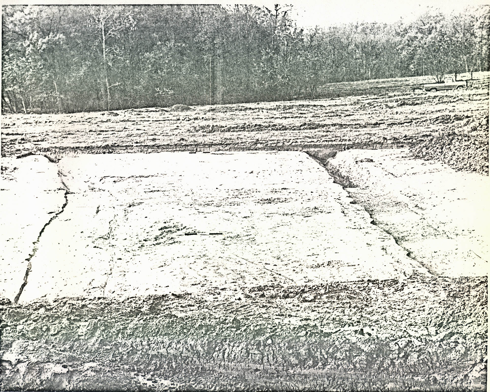 Plate XIX. — View facing south of original topsoil level (CG 439C) containing brick rubble (from construction of mansion outbuildings (?) found beneath sandy fill (CG 439B) from terrace construction (?). Note cross-section through Pit B (on left) (CG 439F, 460H). (See also Figs. 10 & 11). (72 INH 911)
 Plate XX. — View facing south of wine bottle, ca. 1730-45 (CG 439 B) in situ
on brick rubble and original topsoil spread (CG 439C) south of icehouse (?) pit (Pit A). (See also Figs. 10 & 11). (72 INH 912)
30.
or immediately after the construction of the outbuildings flanking the mansion or perhaps during or soon after the construction of the entire mansion-outbuilding complex, c.1749-1755.
Plate XX. — View facing south of wine bottle, ca. 1730-45 (CG 439 B) in situ
on brick rubble and original topsoil spread (CG 439C) south of icehouse (?) pit (Pit A). (See also Figs. 10 & 11). (72 INH 912)
30.
or immediately after the construction of the outbuildings flanking the mansion or perhaps during or soon after the construction of the entire mansion-outbuilding complex, c.1749-1755.
No structural evidence was found related to Pit A; therefore, its function must be based on speculation. It could have been dug for use as a shallow icehouse pit or cold storage cellar beneath a small storehouse built on simple wooden sills. If such a structure were razed, it is possible that nothing archaeologically would remain except the circular pit. The discovery of goose eggs and a complete chicken skeleton at the bottom of the pit fill (CG 460G) could be considered evidence that the pit had been used for an icehouse (i.e., because of the perishable nature of these items). However, no wash layers were found at the bottom (the usual occurrence in icehouses occasioned by the melting ice). At any rate, if the structure was an icehouse, then the destruction date suggested by the artifacts (c.1750-1760) may indicate that the building served a main house pre-dating the mansion (perhaps the "old house" mentioned in the records), but was razed from view when the "new" mansion was built. This interpretation, of course, raises the question about the location of the "old house" itself, which must have been nearby. The 2' 0" x 2' 0" test holes failed to indicate its presence in the immediate vicinity. 31. It may be that the "old house" was located either where the terraces were constructed or where the mansion now stands. But on this score one is left to contend with a 1770 reference to the "old house" repairs.
(5) Main Entrance Road
Several ditches were found in Fields 4 and 6, three generally corresponding to the road shown on the Desandrouin Map of 1782 (See Figure 4). It is likely that such roads had drainage ditches along one or both sides.
One of the main ditches found (CG 913) (Fold out Figure 26) entered the field from the north, (See Plate XXI) skirted the central ravine, then came to an abrupt halt in Field 4 about 800' 0" from the edge of Route 60. Twenty feet from the end of that ditch, another ditch (CG 921, CG 922) branched off to the southwest and ran along the ravine 150' 0", then veered to the south becoming a double ditch for the remaining 400' 0". This generally follows the path of the main entrance road of 1782.
The double parallel ditch was also traced through Field 10 where it continued (CG1529, CG 1535) 350' 0" southwest then 400' 0" south (CG 1529, CG 1532). Another ditch (CG 914, 918) (See Figure 26) entered Field 6 on the same axis as ditch CG 913 20' 0" to the east (See Plate XXI). However, this ditch had an altogether different profile than CG 913 or CG 921, 922. About 100' 0" south of Route 60, it angled to the southeast,
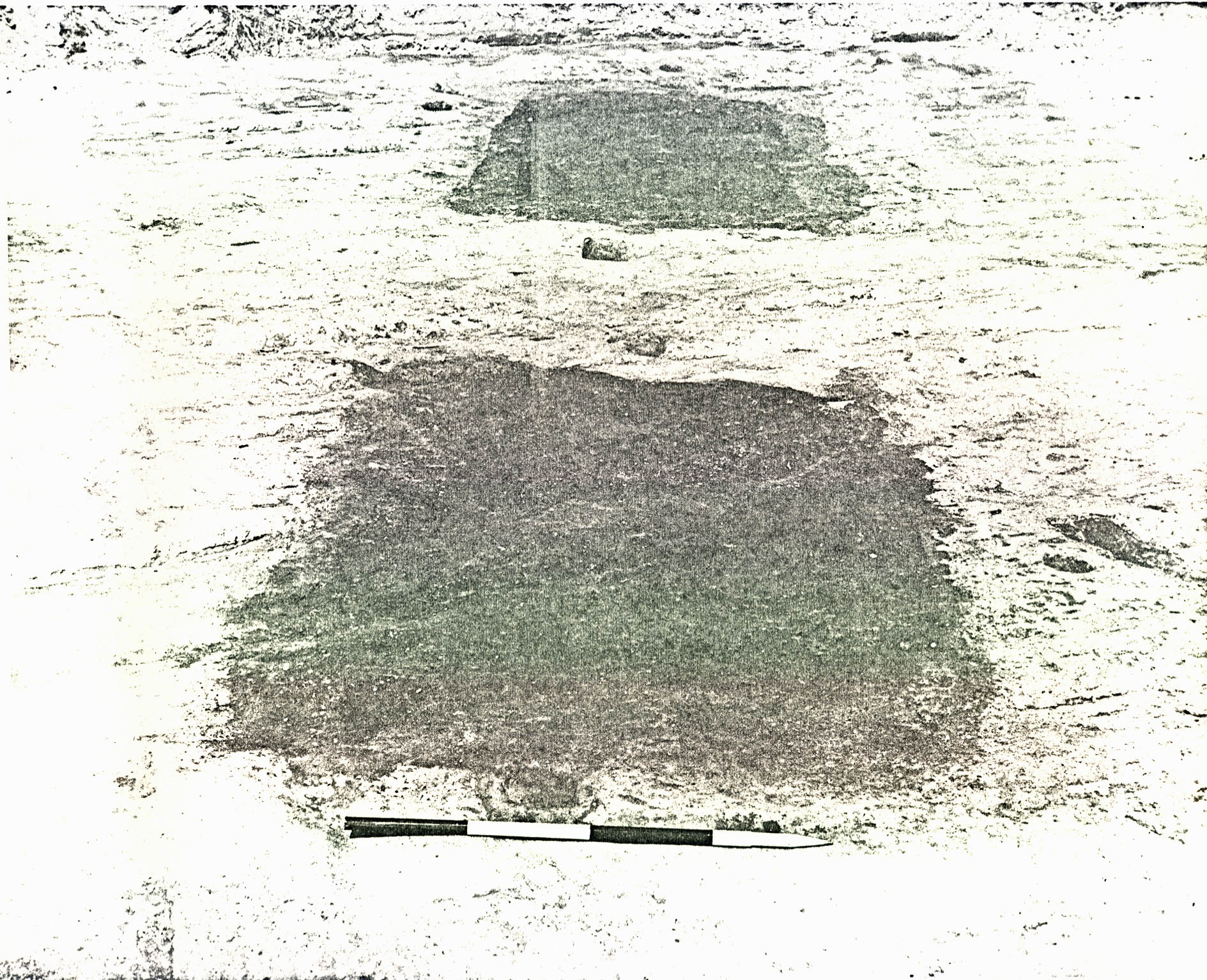 Plate XXI. — View facing south of partially excavated main entrance road ditches (?) (CG 913A, right, CG 914A, left) located near Route 60 field 6. (See also Fig. 1). (72 INH 913)
32
continued (plowing destroyed most of the central section) for 450' 0", then ended abruptly. Glass fragments from a wine bottle (CG 914A) were found in the ditch fill suggesting that it had been backfilled after about 1800. Another ditch (CG 916) crossed ditch CG 918 and ran in an easterly direction 670' 0" to the end of Field 6. Both were apparently open and backfilled at the same time (i.e., neither appeared to cut through the other). Finally, another ditch (CG 907) was found running roughly parallel to Route 60. Perhaps this is the early course of the "York Road" shown in 1782. However, ditch CG 907 cut through ditch CG 913 after it had been backfilled, showing that it had been used later. It should also be emphasized that no traces of the actual roadbeds were found in association with any of the ditches, but probably plowing, sometimes extending to a depth of 1' 2", obliterated any trace of them.
Plate XXI. — View facing south of partially excavated main entrance road ditches (?) (CG 913A, right, CG 914A, left) located near Route 60 field 6. (See also Fig. 1). (72 INH 913)
32
continued (plowing destroyed most of the central section) for 450' 0", then ended abruptly. Glass fragments from a wine bottle (CG 914A) were found in the ditch fill suggesting that it had been backfilled after about 1800. Another ditch (CG 916) crossed ditch CG 918 and ran in an easterly direction 670' 0" to the end of Field 6. Both were apparently open and backfilled at the same time (i.e., neither appeared to cut through the other). Finally, another ditch (CG 907) was found running roughly parallel to Route 60. Perhaps this is the early course of the "York Road" shown in 1782. However, ditch CG 907 cut through ditch CG 913 after it had been backfilled, showing that it had been used later. It should also be emphasized that no traces of the actual roadbeds were found in association with any of the ditches, but probably plowing, sometimes extending to a depth of 1' 2", obliterated any trace of them.
(6) Landing Road (?)
More definite remains of a road were found (CG 1082) running 650' 0" from the west terrace flank down the modern north-south fenceline between Fields 8 and 9 to the small ravine on the river bank 950' 0" southwest of the mansion (Foldout Figure 24). This feature consisted of a bed of clay (CG 1082A) from 41' to 8" thick, 18' 5" wide, crowned across the center (12' 0" wide). In one area (CG 1082), the clay covered an occupation layer and small ditch(?) (CG 1082B) containing artifacts of mid eighteenth-century date. The artifacts from the road fill range in date from the middle of the eighteenth century to the second quarter of the nineteenth century, perhaps 33. suggesting the period during which the road was used.
It is possible that this roadbed is the remains of the eighteenth or early nineteenth-century route to a landing. It seems reasonable that the landing road would skirt the central garden "vista", then take the shortest possible route to the beach. And, if CG 1082 was the landing road, then it follows that the landing itself was located near the aforementioned south ravine.
C. Eighteenth-Century Craft Related Features
1. Tannery(?) and Pits
Surface collecting and subsequent test trenches suggested that structural evidence of eighteenth-century date was located in the north end of Field 13 (Foldout Figure 25). The plow zone was mechanically stripped from the field, which exposed the subsoil surface and archaeological features that had been cut through it. Thirteen rectangular pits of various sizes, a series of ditches, and various backfilled holes and post holes were located in this manner (See Figure 12 and XXII).
a. Tanning Vats(?) Pits A and B
Two of the series of rectangular pits, Pit A and Pit B, set apart from the others, need special mention in that they were the largest and had been lined with wood. (See Plate XXIII). Pit A (CG 715) measured 9' x 6' on the outside extremities and contained a similar wooden box in the center measuring 6'7" x 46". Builder trenches (CG 715B, CG 716G) resulted between the outside edges of the boxes and the original edges of the pit excavation, which had been subsequently backfilled with gold colored clay at the top and mottled yellow clay (Pit B) or sandy fill beneath (Pit A). Both features contained traces of the wooden boxes and where these
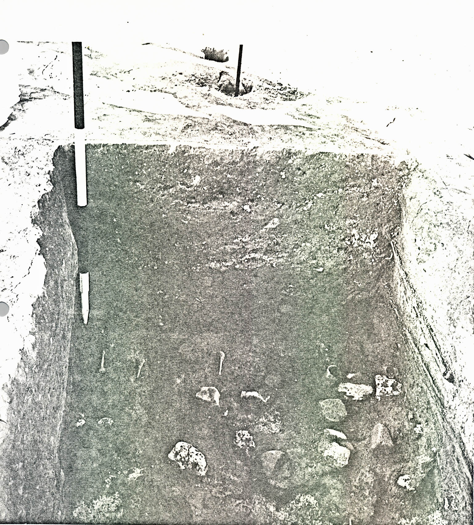 FIGURE 12
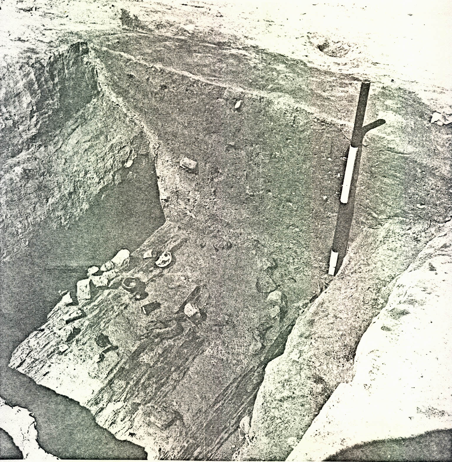 Plate XXII. — View from the northwest of tanning (?) pits in north end of field 13. Note earlier, ditch (CG 719A) across site (left). (See also Fig. 1 for location and Fig. 12). (72 INH 914).
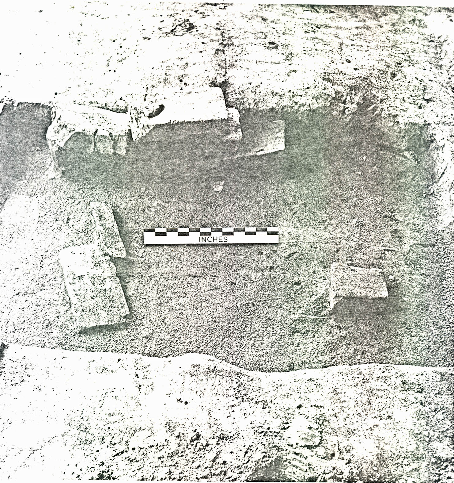 Plate XXIII. — View from the southeast of wood lined tanning pits (?) (Pit A foreground, CG 715), (Pit B background, CG 716) in field 13 before excavation. Note lighter clay fill (CG 715B, CG 716G) builder's trenches (?) around the edges and postholes at the ends of each feature. (See also Figs. 13 & 14)
34.
had rotted away, the nails that had held them together were left in place in the dark brown loam (See Figures 13 and 14). More structural evidence remained in Pit B than in Pit A. Impressions in the sides of the builder's trenches and lines of nails suggested that the boxes had been made up of twelve 2" x 3" "wall studs", four on each narrow side and two on each long side. The studs on the narrow sides were placed one in each corner and one from 3" to 1' 1" from each corner stud or post. The studs on the longest walls were placed from 1' 0" to 1' 6" from each corner and 3' 6" apart on the north wall and 4' 0" apart on the south wall. These four studs were apparently connected to similar sized timbers which acted as floor joists or sleepers supporting the floor boards. The faint traces remaining of the floor and wall boards suggest that they had been from 6" to 1' 0" wide and 5/8" to 1½" thick, depending on evidence based on the apparent thickness of the wood traces or evidence based on the distance between the nail heads and the "clinch" on the spikes found in situ
. Although it was extremely difficult to tell for sure, it is likely that pine was used in the construction of the boxes. The spikes found in line with the stud and joist impressions, and in one case in a section of preserved joist, were 3 ¾" long, had hand-made rose pointed heads, and had been driven in from the outside of the box towards the center. Therefore, the boxes
Plate XXIII. — View from the southeast of wood lined tanning pits (?) (Pit A foreground, CG 715), (Pit B background, CG 716) in field 13 before excavation. Note lighter clay fill (CG 715B, CG 716G) builder's trenches (?) around the edges and postholes at the ends of each feature. (See also Figs. 13 & 14)
34.
had rotted away, the nails that had held them together were left in place in the dark brown loam (See Figures 13 and 14). More structural evidence remained in Pit B than in Pit A. Impressions in the sides of the builder's trenches and lines of nails suggested that the boxes had been made up of twelve 2" x 3" "wall studs", four on each narrow side and two on each long side. The studs on the narrow sides were placed one in each corner and one from 3" to 1' 1" from each corner stud or post. The studs on the longest walls were placed from 1' 0" to 1' 6" from each corner and 3' 6" apart on the north wall and 4' 0" apart on the south wall. These four studs were apparently connected to similar sized timbers which acted as floor joists or sleepers supporting the floor boards. The faint traces remaining of the floor and wall boards suggest that they had been from 6" to 1' 0" wide and 5/8" to 1½" thick, depending on evidence based on the apparent thickness of the wood traces or evidence based on the distance between the nail heads and the "clinch" on the spikes found in situ
. Although it was extremely difficult to tell for sure, it is likely that pine was used in the construction of the boxes. The spikes found in line with the stud and joist impressions, and in one case in a section of preserved joist, were 3 ¾" long, had hand-made rose pointed heads, and had been driven in from the outside of the box towards the center. Therefore, the boxes
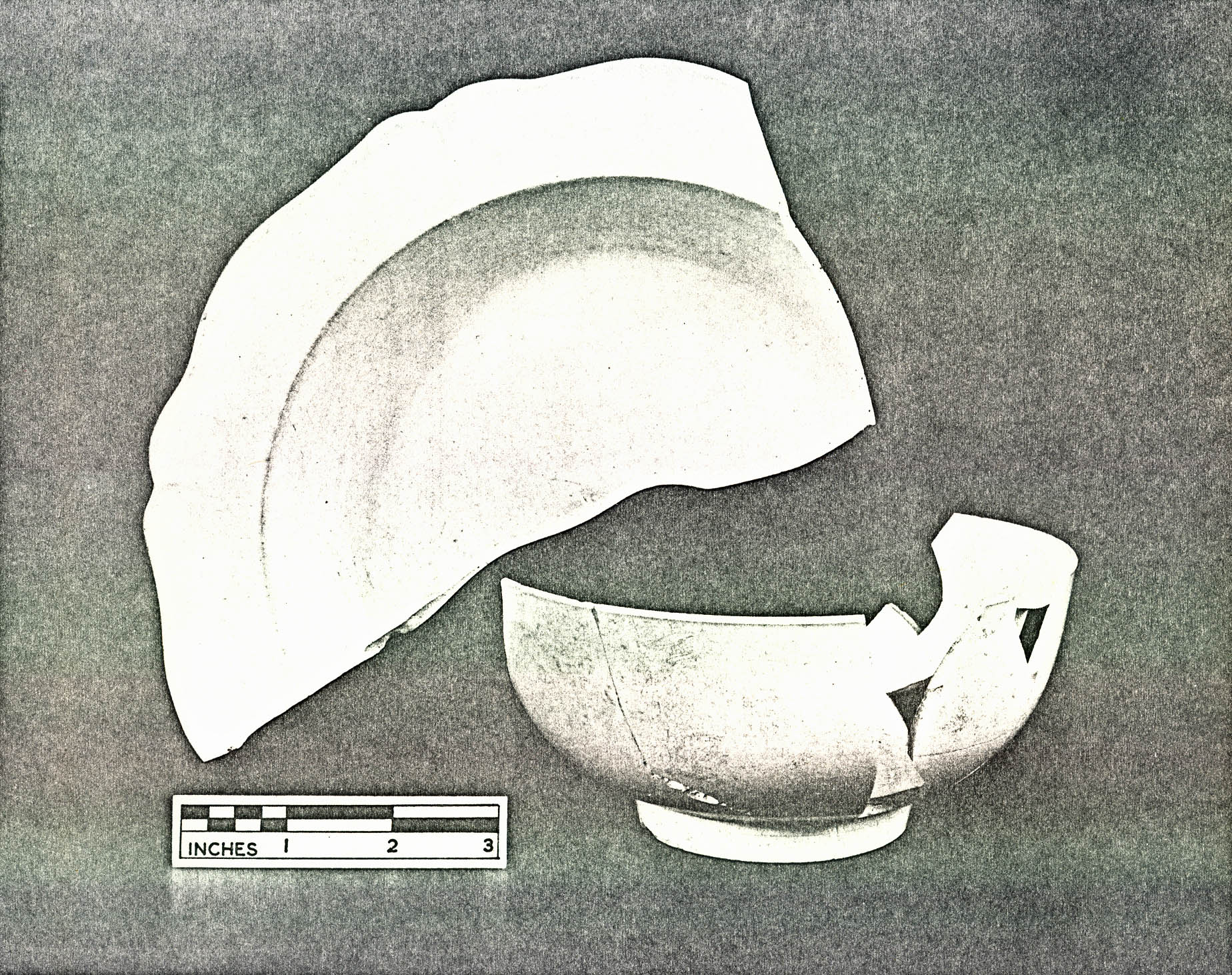 FIGURES 13 & 14
35.
had been constructed outside of the pit, then lowered into place. Subsequently, the "builder's trench" between boxes and pit walls was filled with clay.
FIGURES 13 & 14
35.
had been constructed outside of the pit, then lowered into place. Subsequently, the "builder's trench" between boxes and pit walls was filled with clay.
Pit B was 3' 3" deep and Pit A was 3' 6" deep below the subsoil level; therefore, the studs must have been at least that long. Adding the 1' 0" of plow zone (old topsoil), it is logical to surmise that the pits and boxes must have originally been about 4' 6" deep. It is also logical to assume that Pit A had been built with lumber of the same dimensions as that used in Pit B, although less remained of the studs and joists. What did remain vaguely suggests a similar construction. Both pits had been built in line on a northwest to southeast axis and both had postholes at the center of each narrow side suggesting that some kind of a rack or frame had been built over the boxes.
The stratigraphy in both pits was similar (See Figure 14, Plate XXIV & Plate XXV) in that they had apparently been entirely backfilled with dark brown or black loam (CG 715A, CG 716A) after 2" to 3" of black loam or sandy wash had accumulated at the bottom (CG 716E, F) directly on the wooden floor boards.
Pit B contained lenses of lime and oystershells and some traces of lime were also found in the filling of Pit A. Pearlware sherds found in the upper level of fill in both pits (CG 715A, CG 716A) suggest that the backfilling had
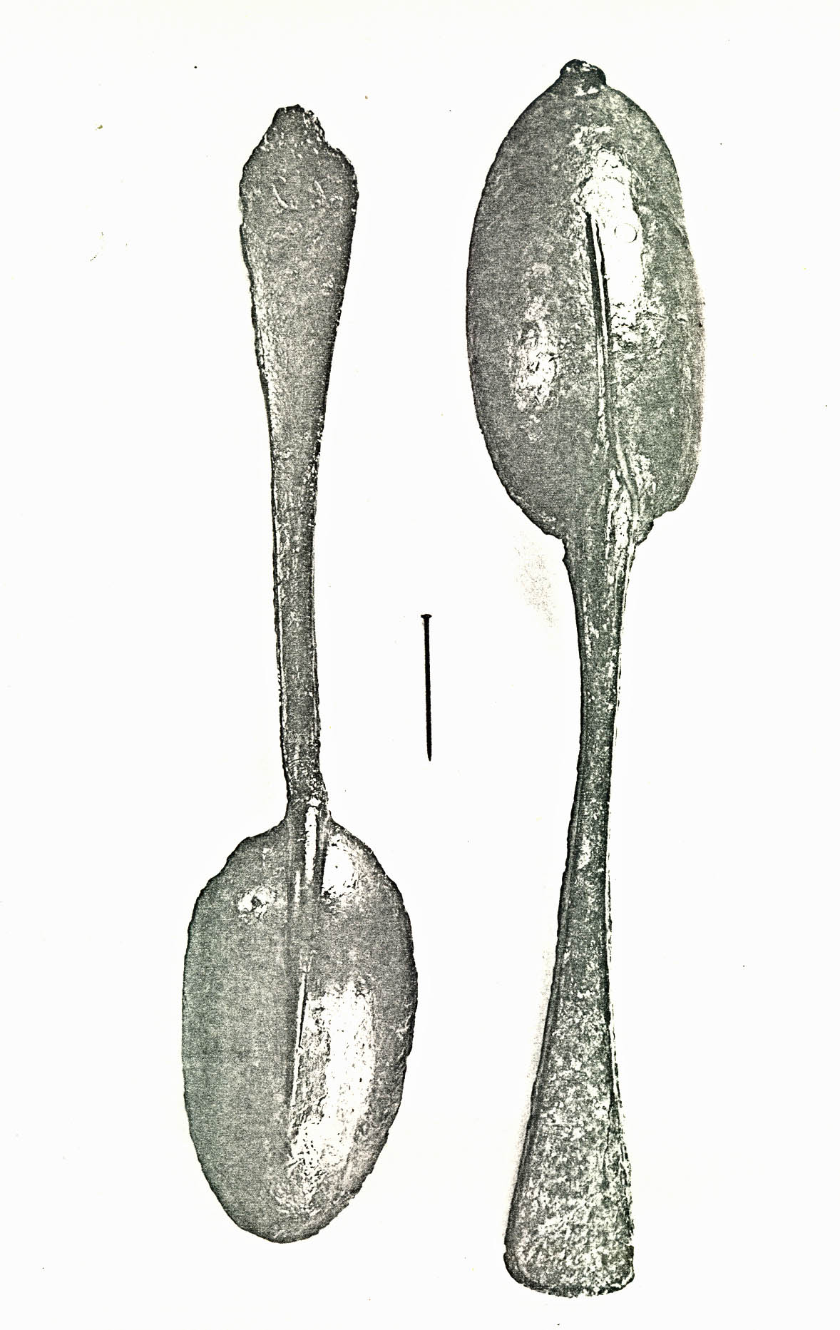 Plate XXIV. — View from the northeast of wood lined tanning (?) pit (Pit A, CG 715) showing north-south cross section through fill (background) and domestic trash in situ
(CG 715B & C) on floor boards. (See also Figs. 12-14). (72 INH 916)
Plate XXIV. — View from the northeast of wood lined tanning (?) pit (Pit A, CG 715) showing north-south cross section through fill (background) and domestic trash in situ
(CG 715B & C) on floor boards. (See also Figs. 12-14). (72 INH 916)
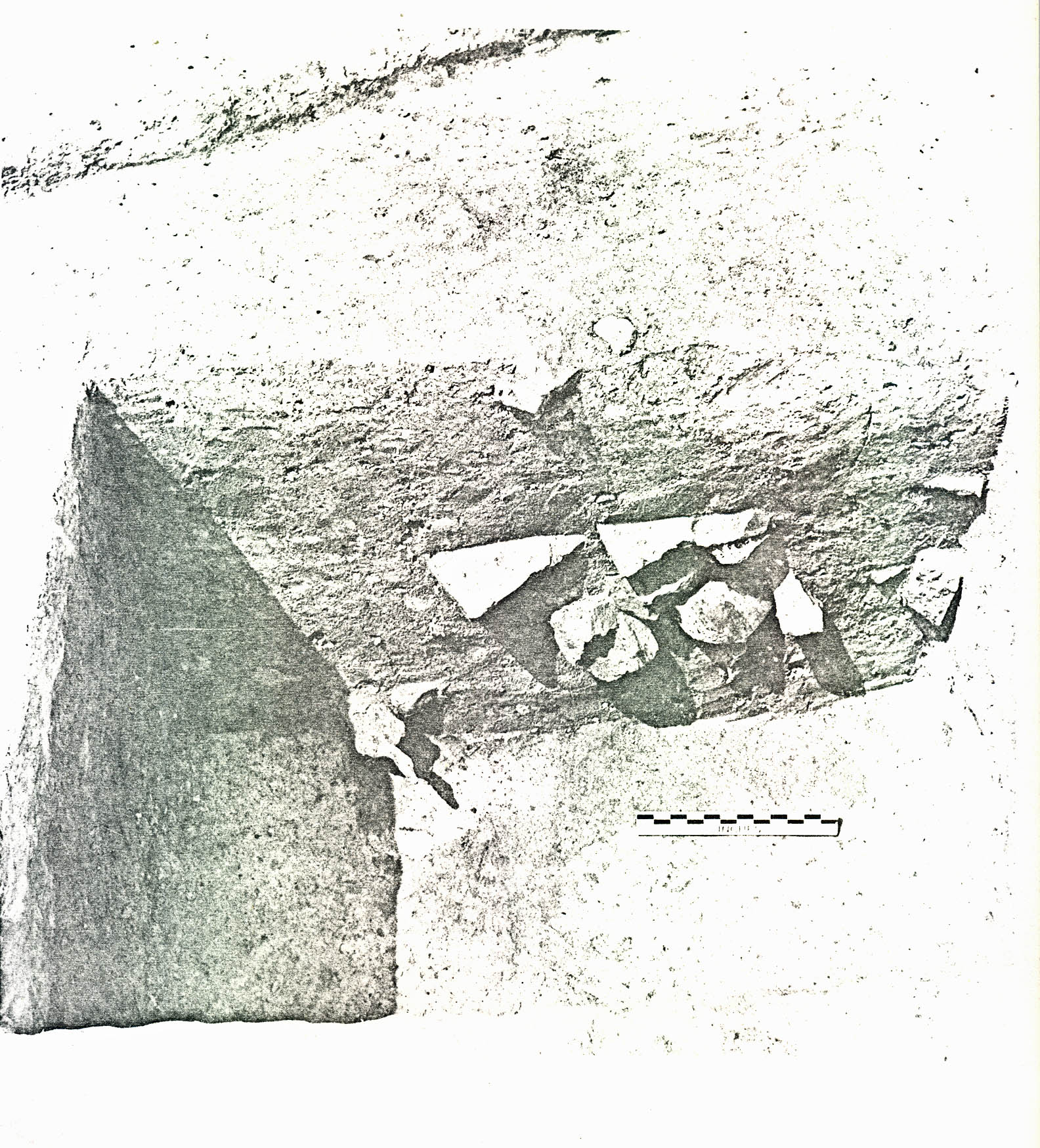 Plate XXV. — View from the east of wood lined tanning (?) pit (Pit B, CG 716) showing north-south cross-section through fill (background) and domestic refuse in situ (CG 716E) on floor boards. (See also Figs. 12-14). (72 INH 917)
36.
occurred after 1785. Crossmends of pottery between the upper backfilling levels of Pit A and Pit B show that they had probably been backfilled and abandoned at the same time.
Plate XXV. — View from the east of wood lined tanning (?) pit (Pit B, CG 716) showing north-south cross-section through fill (background) and domestic refuse in situ (CG 716E) on floor boards. (See also Figs. 12-14). (72 INH 917)
36.
occurred after 1785. Crossmends of pottery between the upper backfilling levels of Pit A and Pit B show that they had probably been backfilled and abandoned at the same time.
b. Smaller Rectangular Pits
Eleven smaller backfilled rectangular pits were found in the area east and north of the wood-lined pits (See Figure 12). They ranged in size from 2' 8" square, 4" deep (Pit F, CG '708) to 6' 2" x 4' 1", 1' 10" deep (Pit L, CG 643) to 5' 6" x 4' 3", 2' 8" deep (Pit N, CG 721). The clay floors of Pit M (CG 704) and Pit N (CG 721) had been scorched by fire. Pit C (CG 702) contained bricks stacked along the south edge (See Plate XXVI) and Pit L (CG 643) included an associated posthole (CG 736A) 3' 0" from the west edge.
Generally speaking, the pits were backfilled with a brown loam fill containing some woodash, some brickbats, and some domestic trash. Pits D thru L (CG 703, 706, 708, 709, 710, 712, 713) contained sherds of creamware (See Plate XXVII) dating their backfilling to after c.1769; Pit H (CG 709) contained a Virginia copper halfpenny (issued in 1775) and a British(?) 7th regimental officer's military button; and a total of ten pewter spoons were found in the pit fill, one (CG 706) (See Plate XXVIII) still retaining untrimmed mold marks indicating that it had never been used.
Pit N (CG 721) was dug on the same compass axis as the other rectangular pits. However, it is located 55' 0" from the
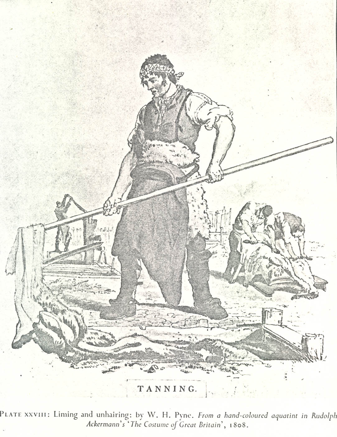 Plate XXVI. — View from the north of Pit C (CG 702), field 13 showing bricks in situ
along south wall of feature. (See also Fig. 12 (72 INH 918)
Plate XXVI. — View from the north of Pit C (CG 702), field 13 showing bricks in situ
along south wall of feature. (See also Fig. 12 (72 INH 918)
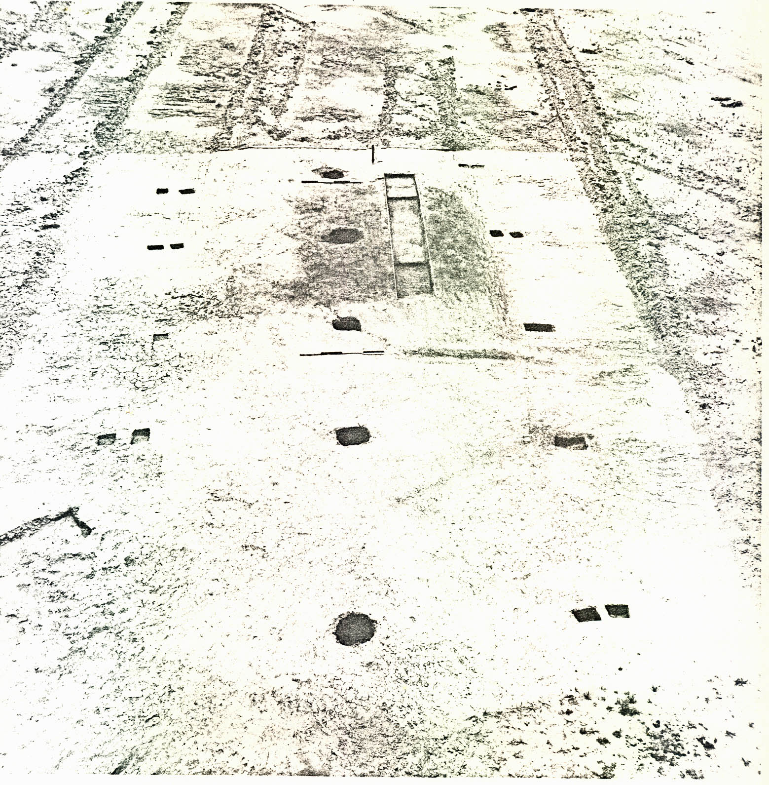 Plate XXVII. — Typical creamware types from the small rectangular pit area, field 13. (Top: Royal Pattern plate, CG 713C, Pit G, bottom: bowl, CG 643A, CG 643B, CG 706A, Pit E and Pit L), both after ca. 1769. (72 NJI 267)
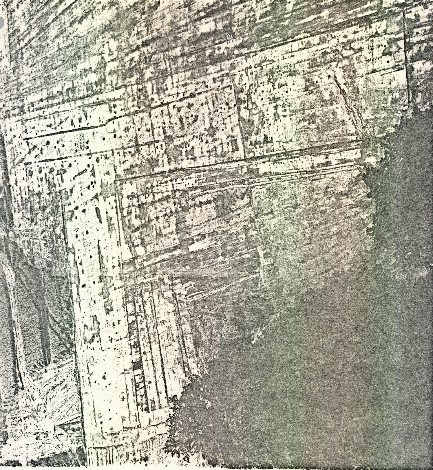 Plate XXVIII. — Two of ten pewter spoons recovered from the fill in the small rectangular pits, field 13. Note: untrimmed mold flaw on tip of spoon on the right (CG 706A) showing that it was never used and molded maker's mark (unreadable) on back of handle of spoon on the left (CG 643A). 72 NJI 274)
37.
other relatively closely spaced rectangular features. Also, as mentioned above, a fire had scorched the clay floor and much care had been taken to make the sides vertical. The pit contained four separate layers of fill (See Figure 12) inset) and Plate XXIX: (1) mottled clay at the top (CG 721A); (2) a brown loam layer (CG 721B) containing a considerable quantity of brickbats and whole bricks; (3) 6" of concentrated woodash containing most of the artifacts (CG 721C); and finally, (4) a burnt clay floor scorched to a depth of about 1" (CG 721D). The presence of a hand-painted pearlware cup base (CG 721C) suggests a backfilling date of some time after 1785.
Plate XXVIII. — Two of ten pewter spoons recovered from the fill in the small rectangular pits, field 13. Note: untrimmed mold flaw on tip of spoon on the right (CG 706A) showing that it was never used and molded maker's mark (unreadable) on back of handle of spoon on the left (CG 643A). 72 NJI 274)
37.
other relatively closely spaced rectangular features. Also, as mentioned above, a fire had scorched the clay floor and much care had been taken to make the sides vertical. The pit contained four separate layers of fill (See Figure 12) inset) and Plate XXIX: (1) mottled clay at the top (CG 721A); (2) a brown loam layer (CG 721B) containing a considerable quantity of brickbats and whole bricks; (3) 6" of concentrated woodash containing most of the artifacts (CG 721C); and finally, (4) a burnt clay floor scorched to a depth of about 1" (CG 721D). The presence of a hand-painted pearlware cup base (CG 721C) suggests a backfilling date of some time after 1785.
c. Relationship and Interpretation
Because of the subsequent plowing, there was no way to relate the pits stratigraphically. However, artifact crossmending, dating of the fill and spacial considerations together suggest:
- (1)They have a related function.
- (2)They stood open at the same time.
- (3)They were backfilled at the same time (c.1780-1790).
- (4)They were backfilled with material from the same source (i.e., domestic refuse from the same building).
Although the artifacts suggest that a temporal relationship had existed among all the pits, the presence of
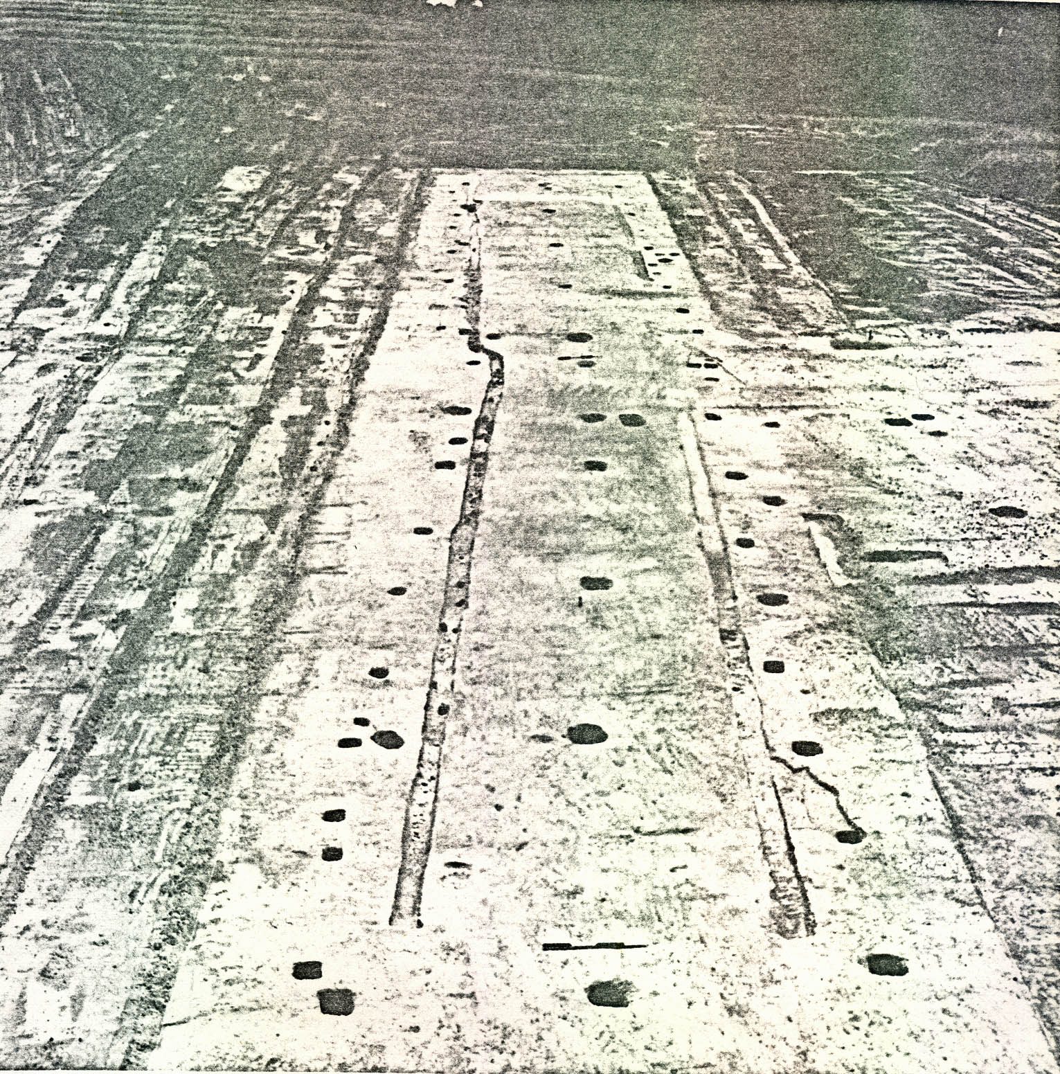 Plate XXIX. — View from the southeast of Pit N field 13 (CG 721) showing north-south cross-section through fill above scorched clay floor. Note iron trowel (CG 721C) projecting from bottom layer of fill. (See also Fig. 12). (72 INH 919)
38.
pearlware in the two wood-lined pits (A and B, and in Pit N) seems to indicate that they were filled last. Ceramics crossmended between Pit A and Pit B, but not directly with the others. However, pieces of what appear to be from the same Chinese porcelain plate were found in Pit B and in Pit J (CG 710). Pit J, in turn, contained a sherd of Colono-Indian pottery identical to Colono-Indian pottery found in Pit H (CG 709) (shown above to have also contained the Virginia halfpenny of 1773). Thus, regardless of the pearlware in Pit A and Pit B, it is still likely that the large wood-lined pits were used at the same time as the nearby smaller rectangular pits.
Plate XXIX. — View from the southeast of Pit N field 13 (CG 721) showing north-south cross-section through fill above scorched clay floor. Note iron trowel (CG 721C) projecting from bottom layer of fill. (See also Fig. 12). (72 INH 919)
38.
pearlware in the two wood-lined pits (A and B, and in Pit N) seems to indicate that they were filled last. Ceramics crossmended between Pit A and Pit B, but not directly with the others. However, pieces of what appear to be from the same Chinese porcelain plate were found in Pit B and in Pit J (CG 710). Pit J, in turn, contained a sherd of Colono-Indian pottery identical to Colono-Indian pottery found in Pit H (CG 709) (shown above to have also contained the Virginia halfpenny of 1773). Thus, regardless of the pearlware in Pit A and Pit B, it is still likely that the large wood-lined pits were used at the same time as the nearby smaller rectangular pits.
Before the entire area, now in woods, surrounding Field 13 can be excavated, there is probably little value in drawing rigid conclusions as to the function of the pits. However, the excavations so far strongly suggest certain possibilities.
The wooden linings and flooring, the postholes at each end, and the presence of lime in the fill can all be considered evidence that Pit A and Pit B were used in tanning leather. Historical documents seem to fit the archaeological evidence. The preparation of the pelts required repeated soakings in lime pits or vats, and the tanning process itself required long-term soaking of the prepared pelts in a series of vats containing tannins. Presumably the extraction of the organic 39. tannin would require cooking of leaves or bark over a low steady heat. Perhaps the fire pits (M and N) were used for this function while Pit A and Pit B were used for pelt preparation and/or tanning. Diderot shows a sketch of a tannery with round vats ranging in function from lime soaking to fire pits used in heating cauldrons of tanning solutions.20 Moreover, a sketch of W. H. Pyne (1808, See Plate XXX) shows tanning being done in rectangular wood-lined vats with recessed corner posts strikingly similar to Pit A and Pit B at Carter's Grove. Pyne also shows "clothes-lines" in the background used as drying racks, which may have been the purpose of the postholes (See below) found near the vats at Carter's Grove. Finally, entries in the Burwell Ledger in the years 1742-64, 1765, 1773, 1774, and 1782, shows that leather was being tanned at Carter's Grove.21 In fact, Carter Burwell was so adapt at the craft that he sent detailed instructions concerning hide curing to Thomas Jones in 1749.22
Another possible interpretation of the rectangular pits suggested by the nine smaller pits, the military button recovered in Pit H (CG 709), and the lack of structural evidence is that the field was the site of a military encampment — the smaller pits being merely a series of backfilled latrines. However, one military button is hardly enough evidence by itself to show a military function of the features
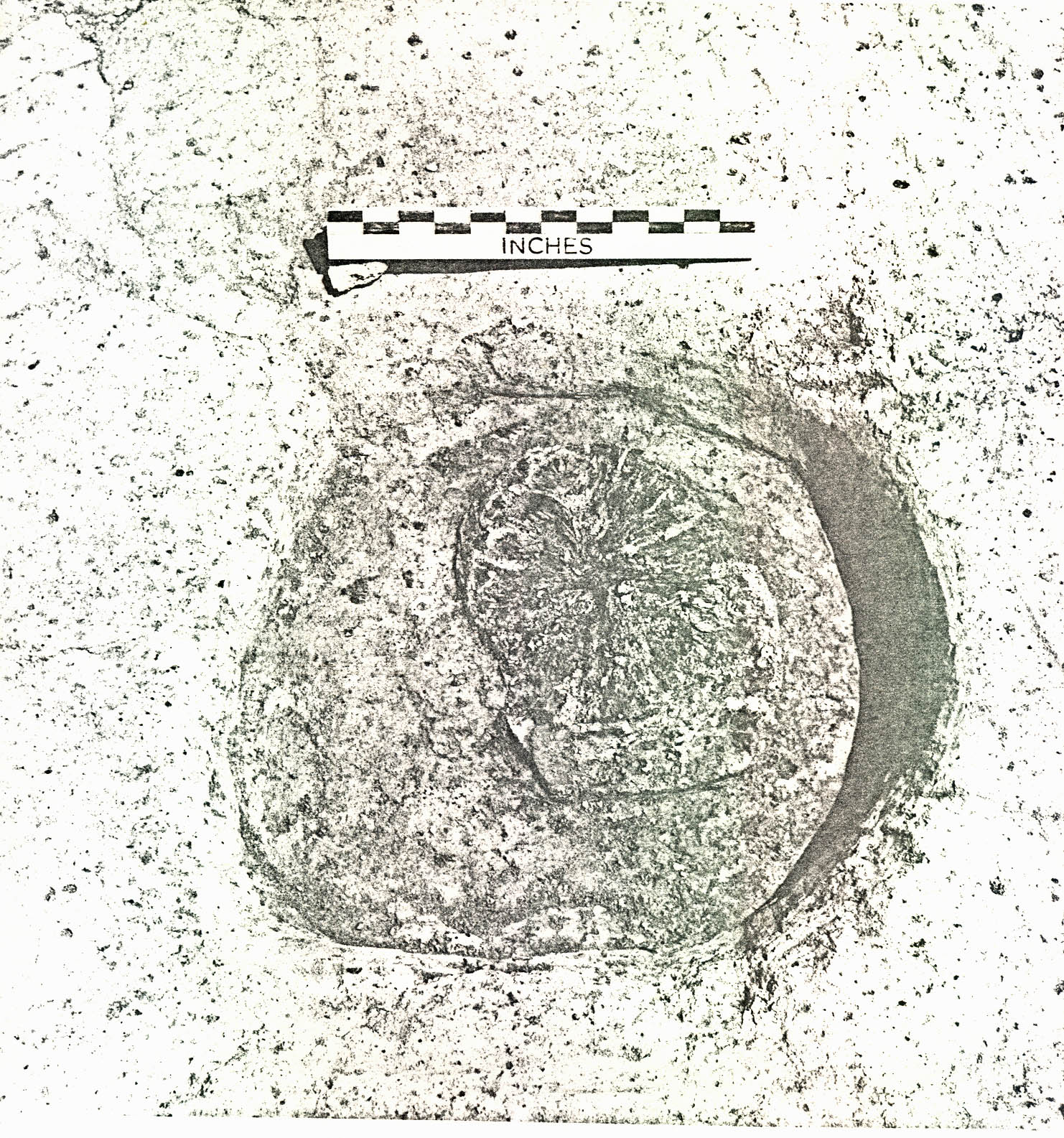 Plate XXX. — Rectangular wood lined tanning vats as sketched in 1808. Note recessed corner posts matching slots found at corners of Pit B (CG 716) at Carter's Grove. (See also Fig. 13).
40.
and the permanent nature of the wood-lined pits seem to rule it out. Also, one must always keep in mind the possibility that excavations in areas to the west and north of the field will produce structural evidence.
Plate XXX. — Rectangular wood lined tanning vats as sketched in 1808. Note recessed corner posts matching slots found at corners of Pit B (CG 716) at Carter's Grove. (See also Fig. 13).
40.
and the permanent nature of the wood-lined pits seem to rule it out. Also, one must always keep in mind the possibility that excavations in areas to the west and north of the field will produce structural evidence.
The presence of ten pewter spoons in the backfilling of the pits, one still retaining the untrimmed mold flaw on the tip of the bowl (CG 706A), might be considered further evidence that the pit area had been used for crafts (See Plate XXVIII). However, one would have expected to find considerable quantities of lead and pewter waste, particularly around the fire pits (Pit M and Pit N). None was recovered. Moreover, there does not seem to be any consistency in style among the spoons. Two different types were found (See Plate XXVIII). It is logical to assume that if spoon manufacture was being carried out in the area, the styles would probably not be so varied. Also, two different maker's marks were found on the spoons (CG 643A, CG 707A).
Archaeological conclusions must be based on the positive evidence at hand. However, in the case of the features found in Field 13, the unusual absence of wine bottle glass in the backfill of the pits may be significant. Fragments from no more than five wine bottles were found in the fill of the smaller rectangular pits. The lack of wine bottles, although it is negative evidence, might help in determining the origin of the fill itself. It is logical to assume 41. that for obvious reasons, the issuance of liquor to slaves would be kept at a minimum or prohibited altogether.23 If this were the case at Carter's Grove, then there is every reason to believe that domestic refuse from slave quarters would contain very little wine bottle glass.
d. Other Features
Pit M (CG 704) had been dug through a shallow, narrow, backfilled ditch (CG 719) which ran at least 86' across the pit area in a southwest-northeast direction. It is certain, therefore, that the ditch had been abandoned and backfilled before the area began to be used for pits. About 21' 0" from the northeast end of the ditch, a smaller connecting ditch had been dug at about an 80° angle to the longer ditch which gradually became shallower and disappeared about 17' 0" from the junction. At 61' 0" from the northeast end, the ditch (CG 719) had also been cut through by the digging and backfilling of a small trash pit or tree hole (CG 740E), the artifacts suggesting a deposition date in the period 1760-1770. Only two artifacts were found in the long ditch fill (CG 719A) — a minute sherd of Chinese porcelain and a fragment of a pipe bowl, both not specifically datable. But it is reasonable to suppose that the ditch had silted up and had been abandoned before c.1760-1770, the deposition date of the trash in feature CG 740E.
42.Additional ditches of uncertain purpose were also found northeast of the pit area (CG 740A-C, 740D-E) and three irregular holes, presumably backfilled tree holes (CG 700, CG 707, CG 701) and a borrow pit, were found in the area of the rectangular pits. The borrow pit (CG 714) had the rough appearance of a rectangular pit at first, but it had extremely irregular sides and had been dug into an area where the subsoil consisted of an outcropping of gold clay. It is extremely probable that the clay from this pit was used to fill in around the wooden boxes in Pit A and Pit B (See page 33 ).
Numerous post holes were found in the area of the rectangular pits, six of which (CG 724, 725, 726, 729, 730, 732) may have been contemporary with each other and may have been dug to support the posts of a crude structure or drying rack. However, with the absence of stratigraphy in the area, there is little evidence to relate the holes, apart from their spacial arrangement. The presence of creamware in some of the backfilling of these holes dates their backfilling after 1769.
About 100' 0" east of the rectangular pit area, an irregularly shaped deposit of dark fill (CG 717) was found measuring 36' 0" x 20' 0" x 9' 0" (See Figure 12). Time and weather stopped complete excavations of this feature, but 16' 0" on the south end was tested. An irregular hole sloping into a ditch 43. 2' 9" deep was found. The ditch had been backfilled primarily with brickbats, some of which had come from poorly fired or overly fired bricks. No mortar was found with the bricks. The artifacts found in the fill suggest that the feature had been backfilled after 1769 and crossmending suggests a relationship with the rectangular pits.
Paving made of unmortared brickbats was found on the east side of the feature measuring roughly 5' 0" x 3' 6". It appeared to have a straight side along the west edge and another straight side along the southwest edge. Time and weather halted further excavations in this area.
Also, surface surveying in the edge of the wooded ravine 70' 0" west of the pit area located a depression 20' 0" wide shaped like an inverted cone (See Figure 25). It is probable that this feature was a well abandoned and allowed to erode in at the top. The feature was not excavated.
2. Brickyard
An area approximately 300' 0" x 400' 0" in the center of Field 8 (Foldout Figure 24), 900' 0" south of the mansion, was mechanically striped of the modern topsoil (8" to 12") exposing features the nature of which suggested that a brickmaking operation had existed in that area during the eighteenth century. At least five separate areas consisting of either: (1) burnt clay; (2) a series of postholes and burnt clay; or, 44. (3) parallel ditches, burnt clay, and a posthole series were found, in all probability the remains of brick clamps.24 Also, three large shallow pits, (probably clay seasoning pits or basins), several smaller pits, a considerable amount of under or overfired brick rubble, and two backfilled wells were found in the same general area.
a. Brick Clamps
Clamp 1
Clamp 1, located 1000' 0" southeast of the mansion, (Foldout Figure 15) consisted of a rectangular area of burnt clay subsoil measuring 43' 0" x 17' 0". The clay had been scorched black, roughly in alternating sections or strips 9' wide on an average. Less black scorched earth and some brick dust were found in the intervening areas vaguely forming strips 3' 9" wide on an average. These alternating deposits may represent fire channels and brick "benches", but the edges of each were extremely difficult, if not impossible, to define exactly.25
No datable artifacts were found in association with Clamp 1.
Clamp 2
A second burned area (Clamp 2) was found parallel to and 10' 0" to the west of Clamp 1 (See Plate XXXI). The burned area was smaller, measuring only 18' 0" x 12' 0". This feature did not appear to have been burned in strips, but in the
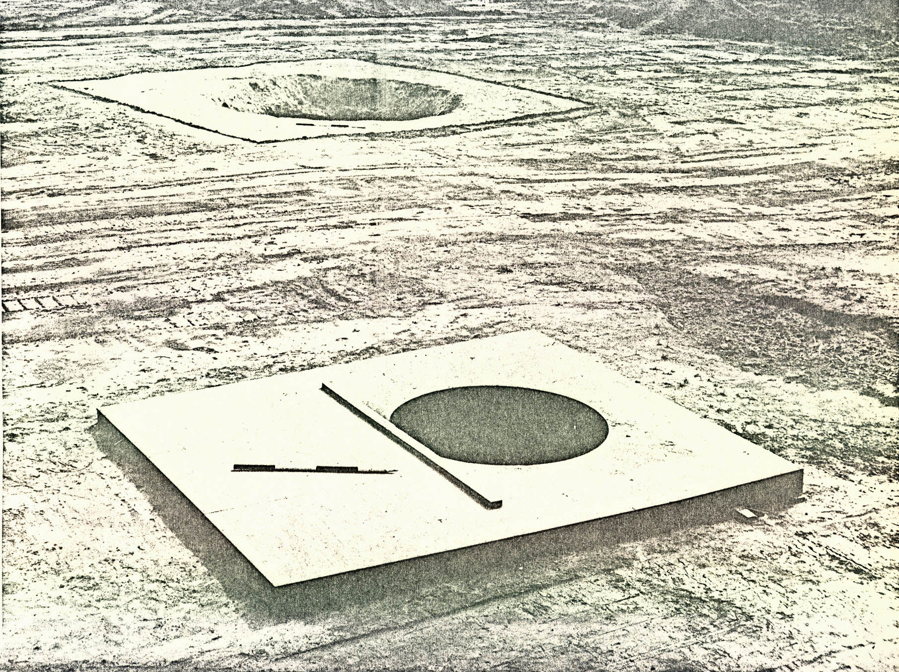 FIGURE 15
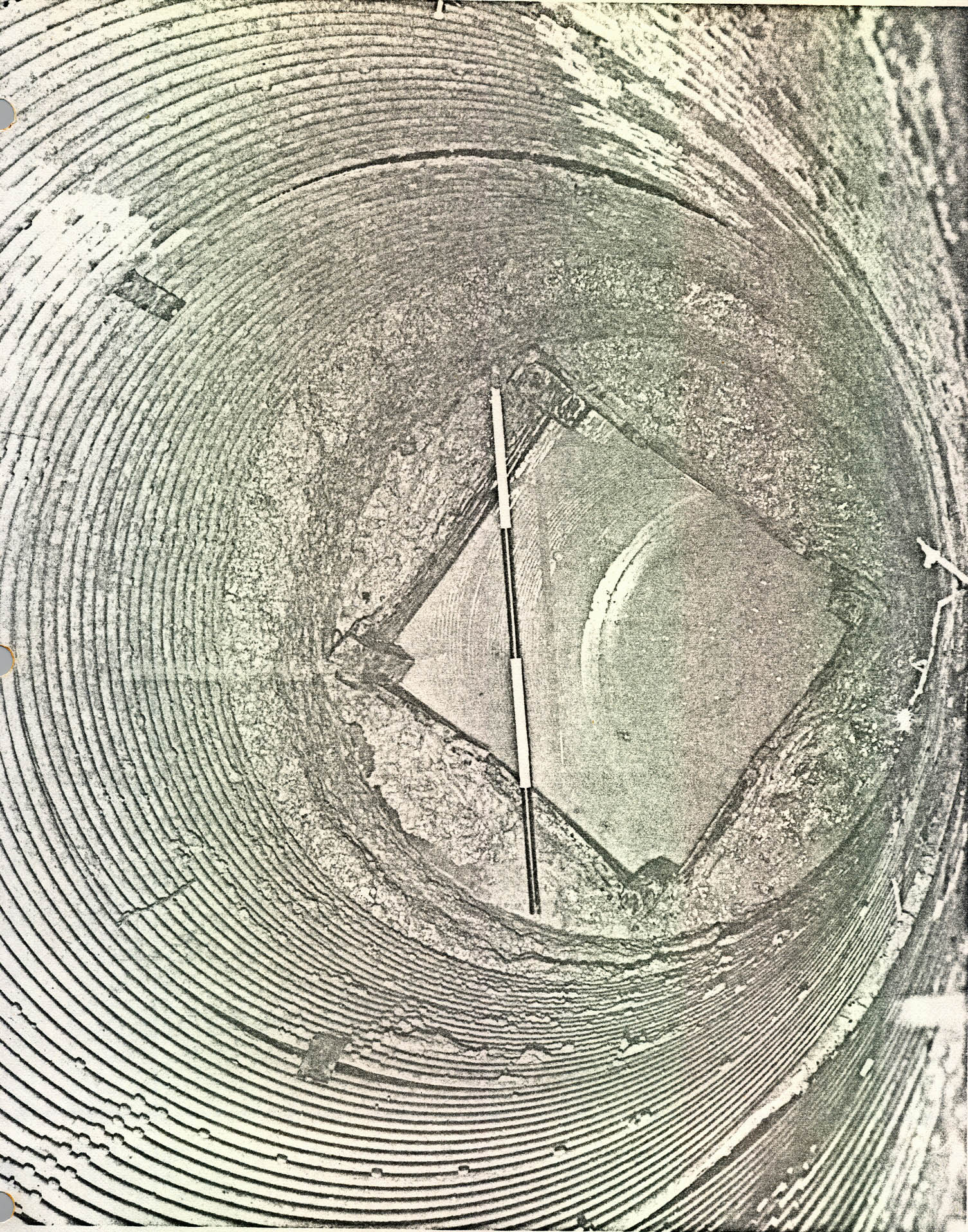 Plate XXXI. — View from the northeast of brick clamp 2, field 8. Note scorched black clay (background center) and symmetrical alignment of postholes. (See Fig. 15) (72 INH 920).
45.
northeast corner, the fire had been hot enough to burn the clay subsoil to a brick-like consistency and color. A row of 5 postholes was found running northeast-southwest through the burnt clay area (1' 1" x 1' 2", 1' 7" deep on the average). The holes were spaced at 9' 6" intervals and one contained the remains of a charred post 6" in diameter. Also, paired sets of smaller postholes(?), averaging 8" x 10", 4" deep, were found about equi-distant (10' 0" southeast and northwest) from the larger central holes, making the clamp 20' 0" x 40' 0". It is probable that the central posts supported the ridge pole and the side holes the eaves of a crude roof or cover.
Plate XXXI. — View from the northeast of brick clamp 2, field 8. Note scorched black clay (background center) and symmetrical alignment of postholes. (See Fig. 15) (72 INH 920).
45.
northeast corner, the fire had been hot enough to burn the clay subsoil to a brick-like consistency and color. A row of 5 postholes was found running northeast-southwest through the burnt clay area (1' 1" x 1' 2", 1' 7" deep on the average). The holes were spaced at 9' 6" intervals and one contained the remains of a charred post 6" in diameter. Also, paired sets of smaller postholes(?), averaging 8" x 10", 4" deep, were found about equi-distant (10' 0" southeast and northwest) from the larger central holes, making the clamp 20' 0" x 40' 0". It is probable that the central posts supported the ridge pole and the side holes the eaves of a crude roof or cover.
Clamp 2 also included a 11 0" wide, 5" deep, 15' 8" long ditch (CG 1181A) running in a southeast to northwest direction along the northeast edge of the burned area. Also, no datable artifacts were found in association with Clamp 2.
Clamp 3
Clamp 3 (See Plates XXXII and XXXIII), located 85' 0" west of Clamps 1 and 2, consisted of a strip of: (1) burnt clay subsoil 190' 0" x 14' 0" - 16' 0"; (2) a 289' 6" long row of 16 central postholes ranging from 10" x 10" to 1' 10" x 2' 7", 11" to 2' 4" deep, containing charred posts 6" to 10" in diameter (See Plate XXXIV);); (3) narrow shallow ditches along each side of the burnt area; and, (4) a series of smaller postholes (averaging 10" x 1' 0", from 6" to 2' 1" deep)
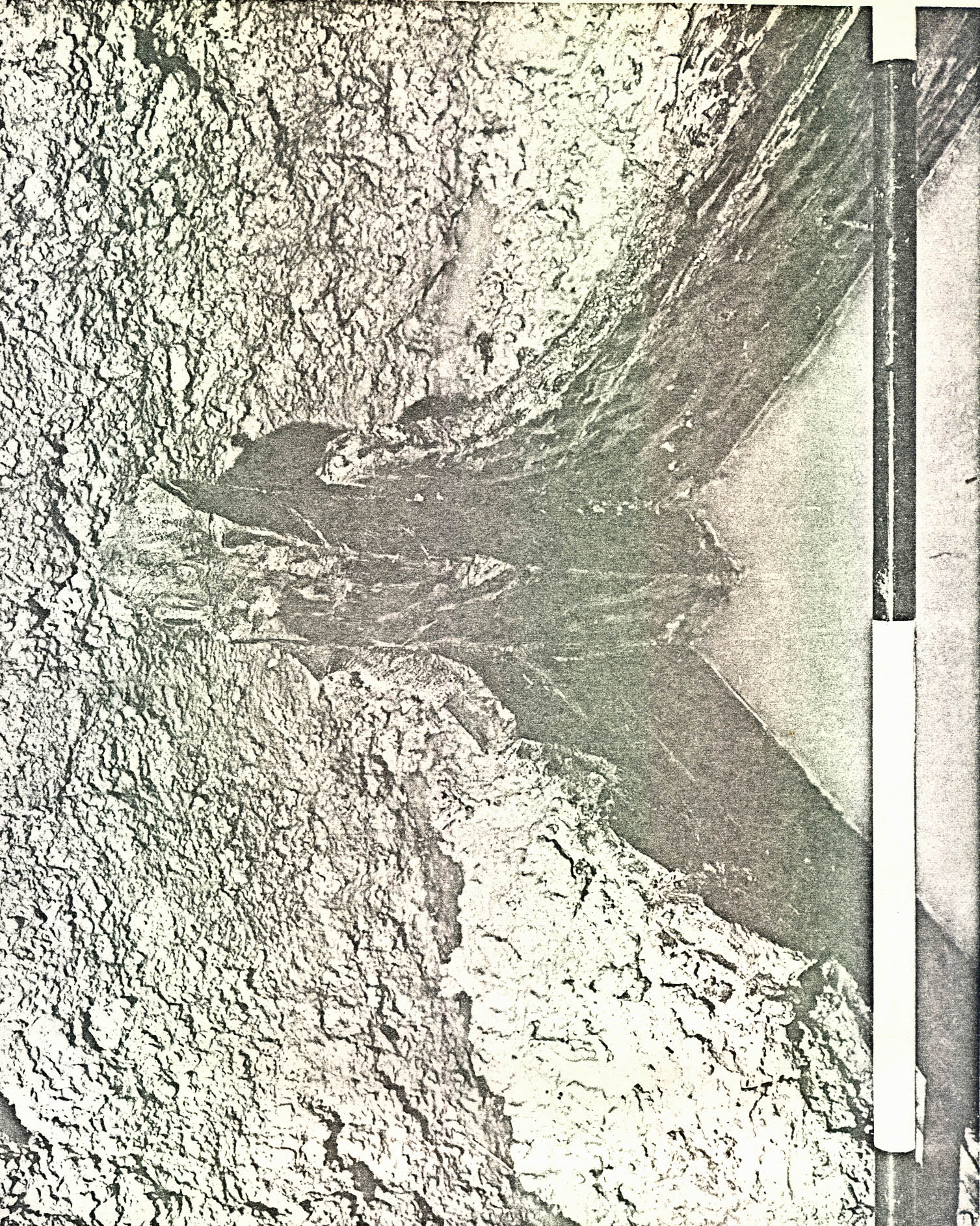 Plate XXXII. — Aerial view of brick clamps 3 (right) and 4 (upper left) from the south. Note alignment of central and side postholes and parallel ditches along northern section of clamp 3. See also Fig. 15 and Plate XXXIII. (71 F D 581-11).
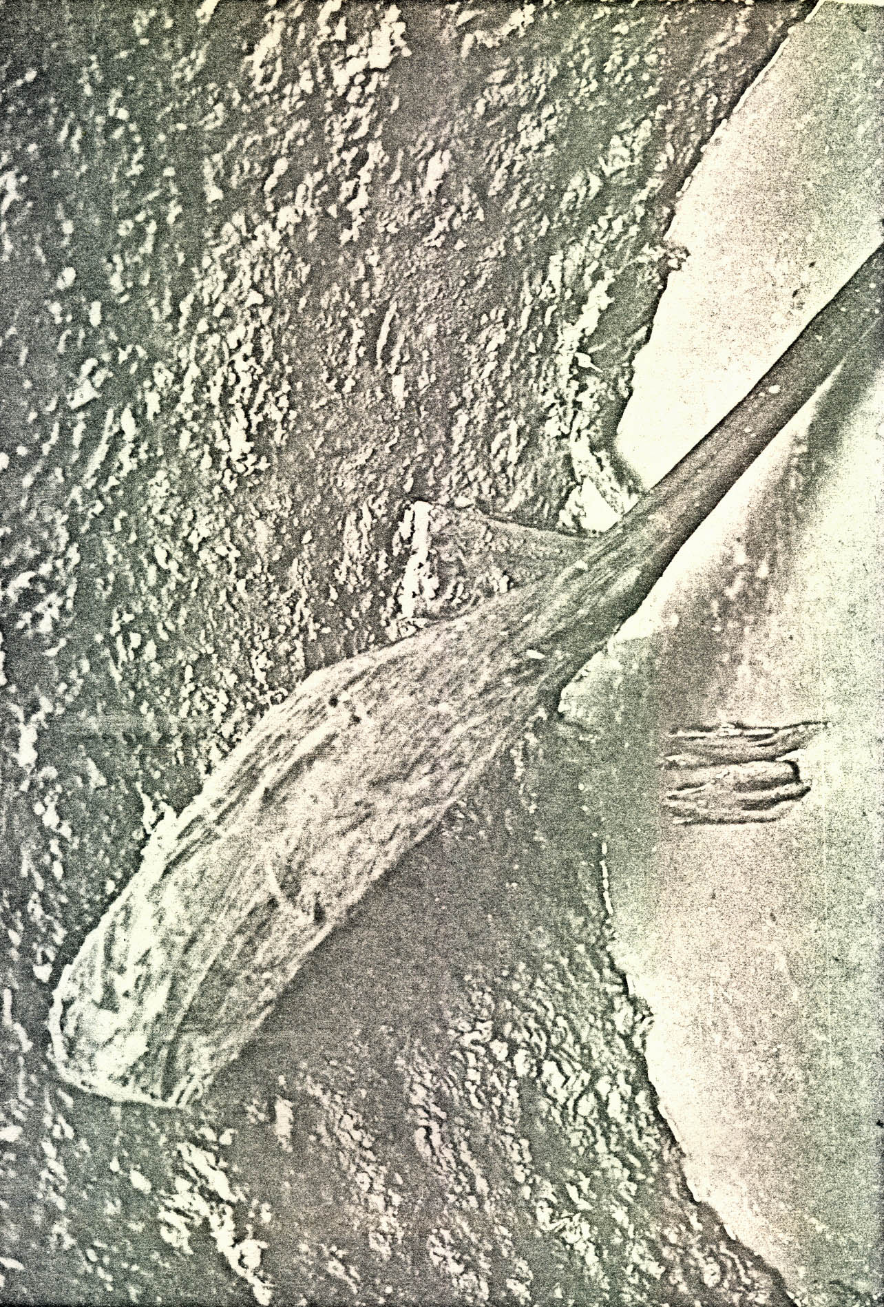 Plate XXXIII. — View from the north of brick clamp 3 partially excavated. (See also Fig. 15 and Plate XXXII. (72 INH 921)
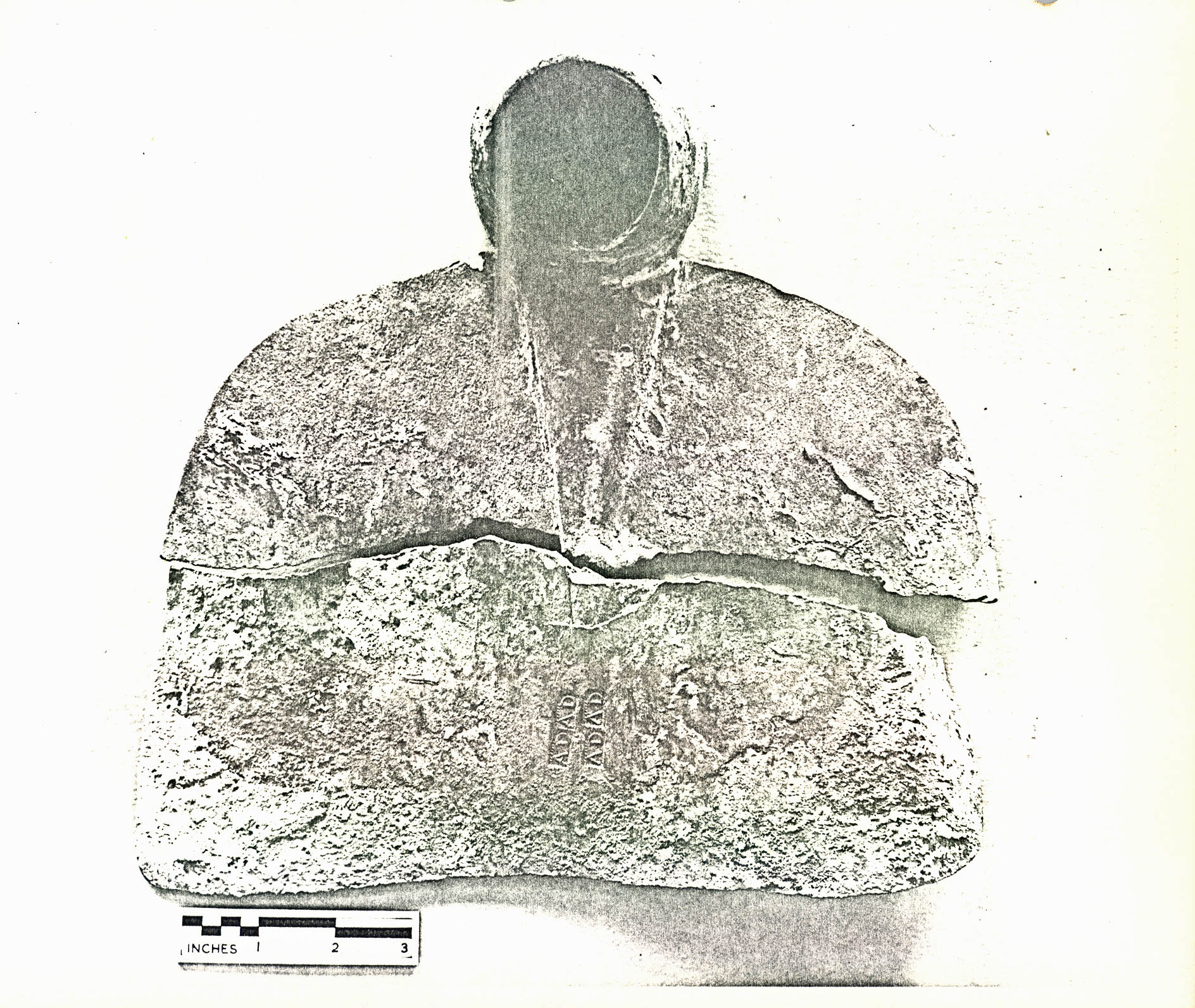 Plate XXXIV. — View from the northwest showing a charred central supporting post in situ
in posthole CG 1203A brick clamp 3. (See also Fig. 16 for photo angle). (72 INH 922)
46.
ranging from 7' 0" to 15' 0" apart along the outside of both ditches. The smaller postholes varied from 22' 0" apart (east-west) at the north end of the feature to 23' 0" apart in the center, and to 17' 6" apart at the south end on the average. A third ditch, parallel to the ditch along the east side of the clamp, was also found measuring 1' 0" wide at the north end to 6" wide at the south end.
Plate XXXIV. — View from the northwest showing a charred central supporting post in situ
in posthole CG 1203A brick clamp 3. (See also Fig. 16 for photo angle). (72 INH 922)
46.
ranging from 7' 0" to 15' 0" apart along the outside of both ditches. The smaller postholes varied from 22' 0" apart (east-west) at the north end of the feature to 23' 0" apart in the center, and to 17' 6" apart at the south end on the average. A third ditch, parallel to the ditch along the east side of the clamp, was also found measuring 1' 0" wide at the north end to 6" wide at the south end.
The plan of this enormous feature (See Figure 15) suggests that it was made up of at least three separate clamps (units), set up on roughly the same line but probably burned at separate times. For instance, the central postholes are not exactly in line throughout, but align in three sections which, in turn, generally correspond to slight differences in the other associated features. More specifically, the first 87' 6" (or the first 6 central postholes from the north) align and the side ditches are parallel 13' 6" to 14' 0" apart (See Figure 15, Unit A). Then the center line of the charred posts shifts slightly to the east for the next 100' 6" (6 central posts), and the side ditches widen (16' 6" to 17' 0"), remain parallel and end about 100' 0" to the south ( Unit B). Beyond that point, the alignment of the remaining 5 central holes (77' 0") shifts again slightly to the east and the side ditches disappear (Unit C). Thus, it appears that the three individual units within Clamp 3 from north to south would have measured about 87' 0" x 14' 0", 100' 0" x 17' 0" and 77' 0" x 14' (?) respectively.
47.A total of six datable artifacts was found in situ in association with Clamp 3. A sherd of English Buckley coarse earthenware of c.1750 (CG 1136A) and a pipe stem possibly of the period c.1710-50 (CG 1136A) were found in the burnt clay area, and a pipe stem of the period c.1710-50 (CG 1225B), sections of a Yorktown pot of post 1730 (CG 1225B), and a burned wine bottle bottom, probably of the period c.1740-60, were contained in the fill of the east side ditch (CG 1225, CG 1225B). Together these artifacts suggest that the clamp was used about c.1740-60, and perhaps after 1750.
Also, a wine bottle neck of c.1740-60 (CG 1237A) found in a shallow brick rubble depression 4' 0" west of the clamp and an eighteenth-century brass spigot found in a similar but larger brick rubble deposit (CG 1234A) located 4' 0" from the first tend to substantiate a mid eighteenth-century date for the use of the clamp.
Clamp 4
A fourth clamp overlapping Clamp 3 and cutting into the west side was also found. The east half of this clamp and the north side of the remaining 75' 0" contained burnt clay. A line of 10 postholes ranging from 1' 0" x 1' 0" to 1' 9" x 1' 10", 1' 8" - 1' 9" deep, ran down the center of the burnt area. Four of the 10 central postholes contained charred posts 5½" to 7½ " in diameter. A north-south ditch 1' 2" wide, 48. 12' 0" long, 5" deep, 14' 0" from the east end and an east-west ditch 11 0" wide, 21' 0" long were also included in the plan of Clamp 4 along with a series of side postholes ranging from 5" x 5", 3" deep to 2' 6" x 2' 10", 2' 4" deep. Thus, for all practical purposes, Clamp 4 included the same features as Clamp 3; i.e., charred central posts, burned clay interior, side ditch, and side postholes. Also, it may be that Clamp 4 had been divided into more than one unit because of the alignment of the central holes. The first 7 holes from the east align (which would make a 90' 0" x about 14' 0" unit) and the remaining 3 holes roughly align, which could have been in the center of a second section, 40' 0" x 14' (?).
No datable artifacts were found in association with Clamp 4. However, as shown above, it was built after Clamp 3; therefore, it is probable that it was used about c.1750.
Clamp 5
The final clamp was found 135' 0" to the north of Clamp 1 and Clamp 2. The burned area measured 62' 0" x 14' 0" and, like three of the other clamps, included a line of central postholes containing burnt posts (holes ranging from 9" x 1' 1" to 1' 4" x 1' 4", posts 5" in diameter) spaced irregularly from 10' to 1' 9" intervals. Also, sections of narrow shallow ditches were found running east-west along each side of the burned area; and outside of the ditches, side postholes about 9" x 9" were found in line with these of the central holes. It is probable that this clamp was set up and burned as one 62' 0" x 14' 0" unit.
49.None of the features of this clamp were excavated; therefore, it could not be dated.
b. Clay Pits
Three large but shallow backfilled pits were also found, two southeast of Clamp 1 and Clamp 2 and one (Pit A) (CG 1091) 10' northeast of Clamp 1 (See Figure 15).
Pit A (CG 1091) measured 62' 0" x 30' 0", the north and east edges being extremely vague. At its deepest point along the southwest edge, the pit was only 1' 6" below natural grade and it contained a brown clay fill with numerous underfired and overfired brickbats (CG 1091C) above a spread of light grey clay (CG 1091D). Both layers, in turn, overlaid a shelf(?) of yellow clay (CG 1091E) with a concentration of underfired brickbats running along the southeast edge. Actually the bottom of the pit sloped toward the shelf(?) which had the appearance of a ditch in profile 1' 7" wide.
Two shallow irregular ditches (CG 1188, CG 1323) led from the pit to a brick-lined well located 4' 0" to the northwest (See pages 55-59). Therefore, it is reasonable to assume that the pit had been dug to catch water drawn from the well.
A wine bottle neck found in the upper layer of fill in the pit (CG 1091C) dates the backfilling to after c.1740-55. Also, the neck joined onto a bottle base (CG 1111J) found some 32' 6" BNG in the well, suggesting both the pit and the well were open, then backfilled at the same time.
50.South and southeast of Pit A (CG 1091) two other large shallow pits were found, Pit B (CG 1322) and Pit C (CG 1464). Pit B (CG 1322) was 8" deep and contained a mottled clay fill with pockets of brickbats, and Pit C (CG 1464) was 1' 3" deep at a maximum and contained similar fill. No ditches were found in association with these pits. Their purpose is uncertain. Also, no artifacts were found in the fill; therefore, it could not be determined whether or not they were contemporary with Pit CG 1091. However, since the same type of brickbats were found in all three features, there remains the strong possibility that they were backfilled at about the same time; i.e., c.1750.
c. The Wells
Two well shafts were discovered some one thousand feet south of the mansion (Field 8) in the vicinity of the brick manufacturing debris (See Figure 15). Although both wells had apparently been filled in about the same time, the fact that one had been robbed of its brick lining (assuming it had been lined with bricks) led to the conjecture that it was the first to be constructed.
Well A
Perhaps due to continuous erosion this earlier (?) well resembled a bomb crater at the top (See Plate XXXV) because it had a diameter of approximately 17' 0". However, the dimension
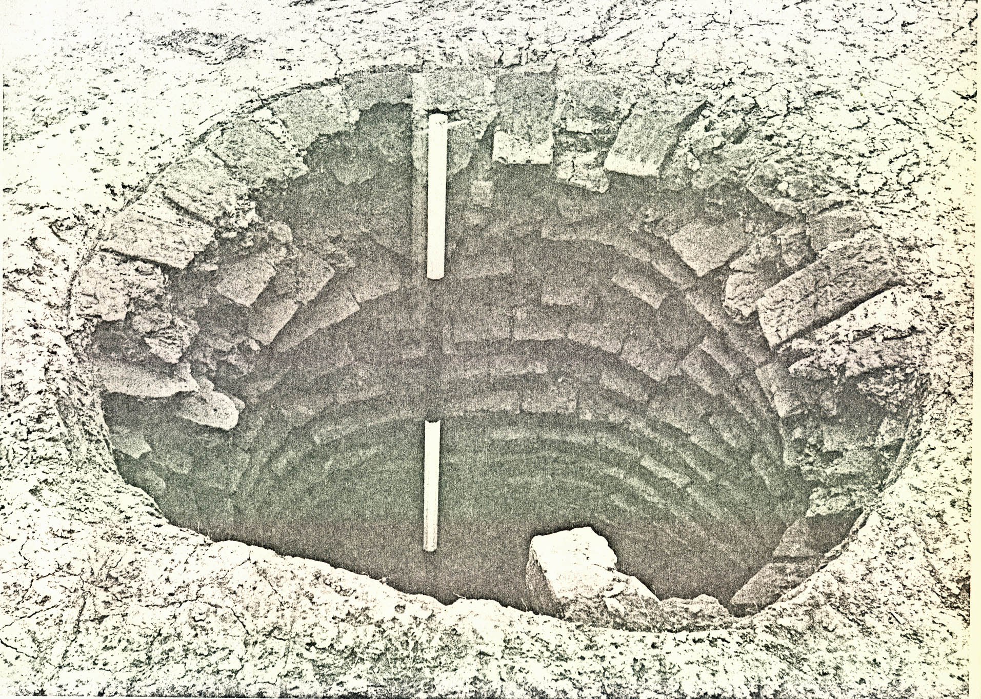 Plate XXXV. — Elevated view showing the relative proximity of the two wells which were presumed to have been used to provide water for the brickmaking operation. The dark circular area in the wooden platform (foreground) is atop the shaft of Well B and the partially excavated Well A is in the background. Notice the eroded sides in the latter. Photographed from the southwest. 71-BK-877
51.
narrowed to a more normal 4' 10" at a depth of 8' 7" below natural grade (See Figure 16) and remained fairly constant to the bottom of the shaft (27' 9" below natural grade). Thereupon, the sides sloped to a maximum depth of 29' 10" (BNG) near the center. As noted above, no bricks were in evidence around the sides and no more than 10 brick fragments were found in the filling, suggesting that the lining was either very carefully robbed or that none had ever been installed. The fact that the remains of a wooden casing were encountered in the lower portion of the shaft seems to imply that the well had not been lined with bricks.
Plate XXXV. — Elevated view showing the relative proximity of the two wells which were presumed to have been used to provide water for the brickmaking operation. The dark circular area in the wooden platform (foreground) is atop the shaft of Well B and the partially excavated Well A is in the background. Notice the eroded sides in the latter. Photographed from the southwest. 71-BK-877
51.
narrowed to a more normal 4' 10" at a depth of 8' 7" below natural grade (See Figure 16) and remained fairly constant to the bottom of the shaft (27' 9" below natural grade). Thereupon, the sides sloped to a maximum depth of 29' 10" (BNG) near the center. As noted above, no bricks were in evidence around the sides and no more than 10 brick fragments were found in the filling, suggesting that the lining was either very carefully robbed or that none had ever been installed. The fact that the remains of a wooden casing were encountered in the lower portion of the shaft seems to imply that the well had not been lined with bricks.
The wooden liner (See Plate XXXVI) consisted of four red oak corner posts (average measurements 7' 11" x 3" x 2-5/8") with wide yellow poplar boards nailed to them from the outside. The tops of the posts were first encountered at a depth of 20' 8" below natural grade and the lower edge of the bottom boards was positioned on level with the bottom of the shaft (27' 9" BNG) with the corner posts continuing down some 10" lower. The poplar timbers used in the wall construction had average dimensions of 2' 11" x 1' 1¼" x 11/8". As already noted, the side pieces had been nailed from the outside (see Plate XXXVII) and, since there was not enough distance between the corner posts and the circular shaft to perform this operation, the casing must have been built above ground and then lowered into its final position.
The fact that the corner posts were found intact with little or no damage to the sawed ends, led to the conclusion
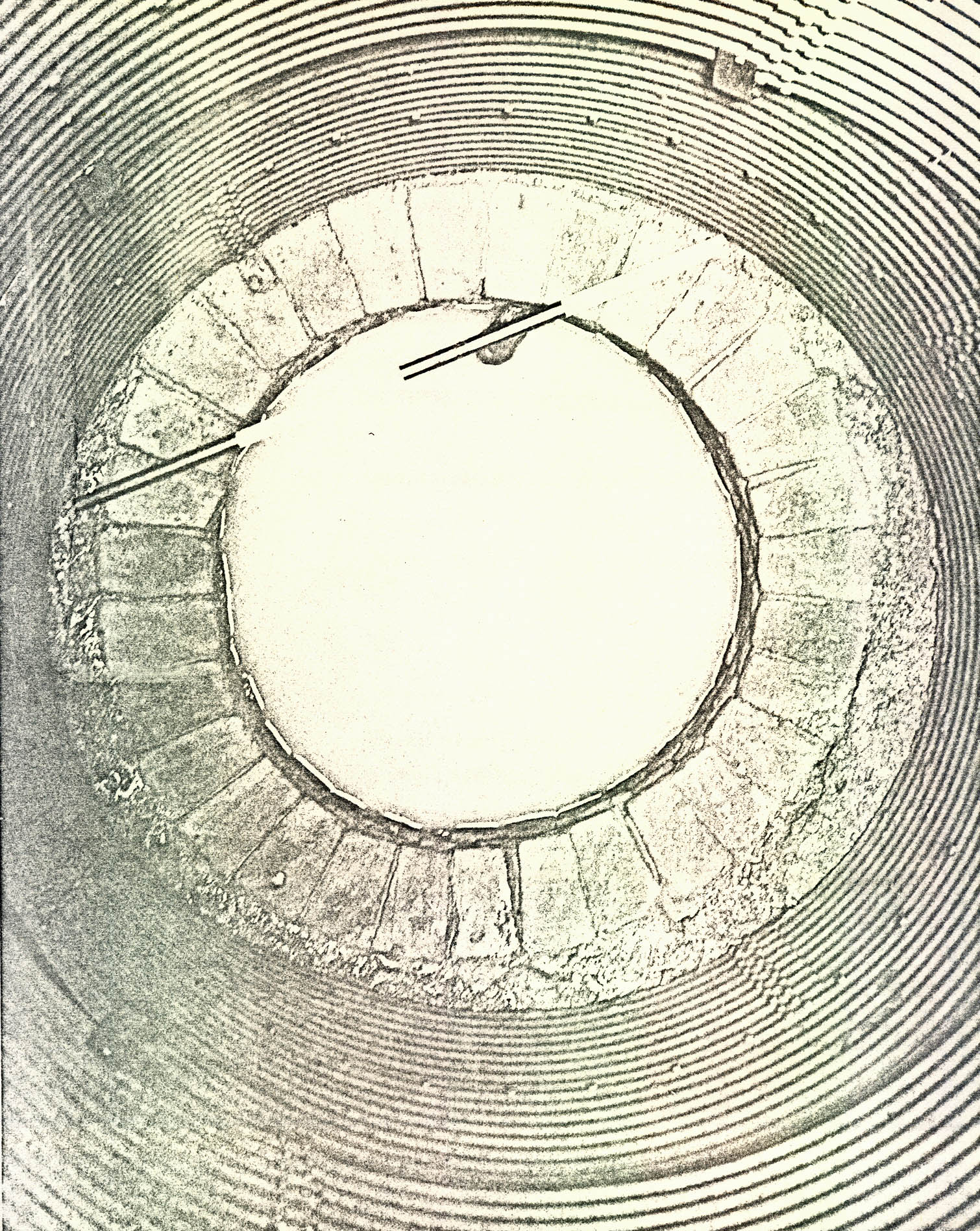 FIGURE 16
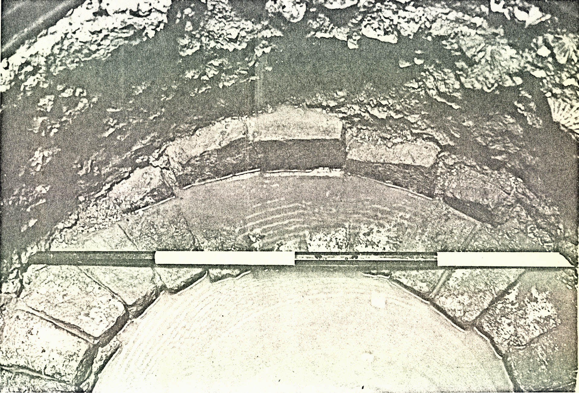 Plate XXXVI. Upper portion of the wooden lining found in Well A. This framework was first encountered at a depth of 20' 8" below natural grade. (71-FD-712)
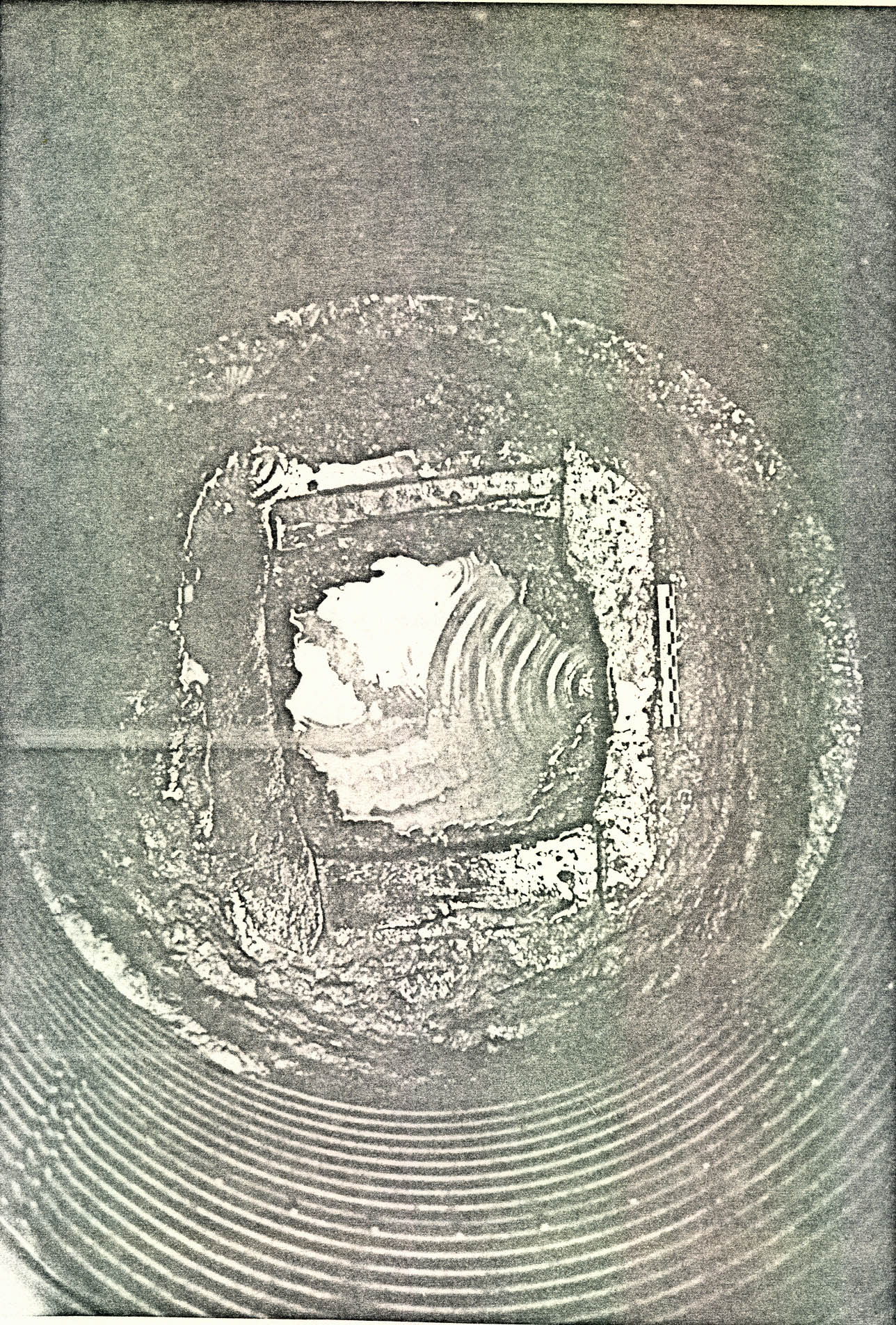 Plate XXXVII. — The northwest corner of the wooden lining found in Well A. Notice that the vertical post is very close to the edge of the shaft. The side pieces had been nailed from the outside so, since there was not enough room for this operation within the shaft, the construction work must have been performed above ground. (Photographed from the southeast) 71-FD-713.
52.
that only a 7' 1" section of the shaft could have been protected by this contrivance. It probably would not have been strong enough to withstand a major cave-in, but this may not have been of primary concern because the sides of the well had cut through tightly-packed marl beds resulting in walls that seemed quite stable. Consequently, it was conjectured that the framework was used as a guide to keep the bucket away from the marl sides as it ascended from the water.
Plate XXXVII. — The northwest corner of the wooden lining found in Well A. Notice that the vertical post is very close to the edge of the shaft. The side pieces had been nailed from the outside so, since there was not enough room for this operation within the shaft, the construction work must have been performed above ground. (Photographed from the southeast) 71-FD-713.
52.
that only a 7' 1" section of the shaft could have been protected by this contrivance. It probably would not have been strong enough to withstand a major cave-in, but this may not have been of primary concern because the sides of the well had cut through tightly-packed marl beds resulting in walls that seemed quite stable. Consequently, it was conjectured that the framework was used as a guide to keep the bucket away from the marl sides as it ascended from the water.
The well's primary fill (CG 1315N) consisted of gray silt with small pieces of marl, but was void of any artifactual remains. The layer began on line with the bottom of the wooden casing (27' 9" BNG), sloping downward to a maximum depth of 29' 10" below natural grade near the center. Directly above the initial deposit was a stratum of silty gray clay (CG 1315M) which was first encountered at 201 0" BNG. This level contained an iron key fragment, the socket and rib portion of an iron hoe blade (See Plate XXXIX), at least 7 pieces of an oval-shaped handle made of oak, and 5 bones from a small animal (An analysis of all bones found in Wells A and B appears in Appendix VIII.
The majority of wooden finds (other than the well's casing) were recovered from a layer of mixed brown clay (CG 1315L) at a depth of between 18' 0" and 20' 0" below natural grade. These included an oak paddle 4' 4" in length, which may have been used in the brickmaking operation (See Plate XXXVIII); no fewer than 13 oak (bucket or tub?) staves l' 3" in length, with surviving clenched nails which indicated
 Plate XXXVIII. — A portion of the oak paddle, first discovered at a depth of 18' 1" below natural grade, which may have been used in the brickmaking operations. Also visible are the tops of two bucket or tub stoves. Photographed from the northwest. (71-BH-882)
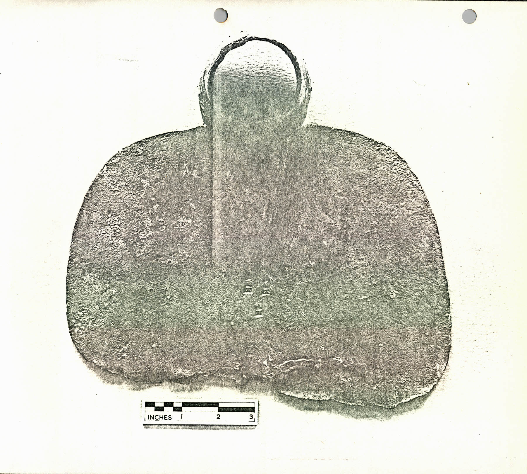 Plate XXXIX. — Two fragments of an iron hoe blade found in different levels of Well A's filling. The lower portion was recovered at a depth of 18' 11" below natural grade and the other was encountered at 28' 2" BNG. Notice the maker's mark "AD" stamped four times near the end of the hoe's spine. 71-INH-788
53.
how the four rows of binding were attached and also that each was ½" thick; one stave with two ½" holes near the top to suggest that a rope handle had been used to carry the objects; a piece of oak binding 2" wide and ½" thick, which had been secured by ¼" dowels; and a large section of oak binding (3' 9" x 4" x ¼") presumably from a barrel. Only one other object was found in the deposit and it was the end of a hoe blade with the initials "A D" stamped four times (See Plate XXXIX). This piece cross-mended with the socket and rib portion described above.
Plate XXXIX. — Two fragments of an iron hoe blade found in different levels of Well A's filling. The lower portion was recovered at a depth of 18' 11" below natural grade and the other was encountered at 28' 2" BNG. Notice the maker's mark "AD" stamped four times near the end of the hoe's spine. 71-INH-788
53.
how the four rows of binding were attached and also that each was ½" thick; one stave with two ½" holes near the top to suggest that a rope handle had been used to carry the objects; a piece of oak binding 2" wide and ½" thick, which had been secured by ¼" dowels; and a large section of oak binding (3' 9" x 4" x ¼") presumably from a barrel. Only one other object was found in the deposit and it was the end of a hoe blade with the initials "A D" stamped four times (See Plate XXXIX). This piece cross-mended with the socket and rib portion described above.
The well's filling from 5'3" to 18' 0" below natural grade produced just two artifacts: a large bone (CG 1315K) tentatively identified as a tibia from an animal smaller than a horse but larger than a dog or sheep (16' 9" BNG), and a small iron grubbing hoe blade (CG 1315J) from a depth of 8' 5" below natural grade. There was no material in the shaft from 5' 3" to 29' 10" (BMG) to even suggest an abandonment date and, therefore, the objects from higher levels were utilized for determining when the well ceased to exist.
The strata in the upper part of the shaft (0" to 5'3" BNG) were well defined, but all seemed to have been deposited at about the same time. The mottled brown and yellow clay (CG 13151) which produced the small hoe blade (See page 52) was partially sealed by a layer of dark brown loam (see Figure 16) with marly shell (CG 1315H) which, in turn, had been covered by a rather extensive deposit of sandy gray clay (CG 1315G). This last stratum contained an English coarseware pan fragment, two nails, and the majority of one wine bottle along with pieces of at least two others from the period c.1740-65. Thus, 54. this date range serves as the terminus post quem for the well's abandonment.
Immediately above the sandy gray clay were layers of washed brown and yellow clay (CG 1315F) and a deposit of sandy brown loam with pebbles and shell bits (CG 1315E). The latter produced 15 beverage bottle side fragments, 2 nails, an unidentified iron strip, and a very thin piece of sheet brass. The washed layers (CG 1315P) contained a vitrified rim section of a Buckley jar, two wine bottle fragments (one of which cross-mends with another found in CG 1315G), 11 nails, and various animal bones including two pieces of a fossilized whale vertebra. A 4"-9" thick deposit of shell (CG 1315C) sealed the above two layers and extended most of the way across the hole (See Figure 16). It contained no fewer than 8 fragments of Colono-Indian pottery (perhaps from a bowl), pieces of a vitrified brown stoneware jar and Buckley pan, numerous wine bottle fragments, 2 vitrified stones, along with miscellaneous bones and nails.
A layer of dark loam with large brickbats (CG 1315B) had been dumped on top of the shell stratum and it, in turn, was covered by a wedge of mottled yellow clay (CG 1315D) which only produced one nail fragment. On the other hand, the loam deposit (CG 1315B) contained 9 pieces of Colono-Indian pottery (bowl?), 3 sherds of a vitrified brown stoneware jar, 2 fragments of English coarseware, a vitrified stone and brick fragment. There were also 3 bases and one neck from wine bottles of the period c.1740-60. The well's top layer consisted of brownish-gray loam with brick flecks (CG 1315A) containing 2 Colono-Indian 55. pan fragments, a piece of a brown stoneware storage jar, and two vitrified sherds — one from a Buckley (jar ?) and the other from a brown stoneware jar.
The fact that at least four crossmends were found among objects in the top 5'3" of the shaft suggests that the layers were dumped in at about the same time. As already noted, the wine bottle fragments from c.1740-60 implied that the well had been abandoned after that period. Nevertheless, it seems quite possible that the well ceased to exist much earlier because the upper 5'3", from which all dating evidence was obtained, could represent filling thrown in to level the area after the shaft's contents had settled.
WELL B
Only 57'6" (center to center) southwest of Well A were found the remains of another abandoned well which, presumably, had also been used to provide water for the brickmaking operations in the area. It was rather crudely constructed in that the upper 27'11" of lining was formed from rectangular instead of compass bricks. This would logically result in a much weaker wall because there was nothing to prevent the sides from caving. As a matter of fact, the top 5'6" of lining showed signs of falling-because the natural clay around it had begun to push the bricks into a much tighter 2'0" diameter and all of them were leaning down toward the center of the shaft (See Plate XL). Nevertheless, the courses below the 5'6" level seemed to have suffered little or no damage, perhaps due to
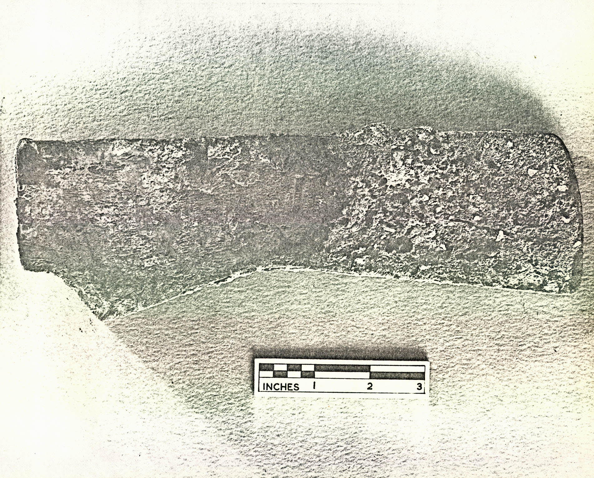 Plate XL. — The upper lining in Well B, made from regular bricks, which showed signs of imminent collapse because the natural clay had begun to push the bricks toward the center of the shaft. Notice how most of the bricks are leaning downward. Photographed from the southeast. 71-BK-878
56.
the fact that most of the shaft had been dug through tightly-packed marl beds (See Figure 17).
Plate XL. — The upper lining in Well B, made from regular bricks, which showed signs of imminent collapse because the natural clay had begun to push the bricks toward the center of the shaft. Notice how most of the bricks are leaning downward. Photographed from the southeast. 71-BK-878
56.
the fact that most of the shaft had been dug through tightly-packed marl beds (See Figure 17).
The lining of the bottom 6'10" (27'11" to 34'9" below natural grade) was built of compass bricks (See Plate XLI) with average dimensions of 7-¾" x (5¼" x 3-¾") x 2-3/8". It should be noted also that these bricks appeared to have been over-fired since they were a much darker red than normal. In this section, the inside diameter of the shaft was 3'5", with each course consisting of 31 bricks. A rather perplexing situation was encountered at a depth of 31'6" (BNG). Five compass bricks had been wedged vertically behind the well's lining on the east side (See Plate XLII), but no explanation was forthcoming; however, it leaves little doubt that the well's lining was constructed from the bottom. The last course was resting on a wooden curb constructed from four shaped boards (white oak) held together by nails. Since the east and west pieces overlapped those on the north and south sides (See Plate XLIII), the wood surface upon which the brick lining rested was not flat. To remedy this situation, a piece of yellow pine had been placed atop the southerly portion of the curb and secured with two nails; however, no matching filler was found overlying the northerly board and no nails pierced it.
The primary fill (CG 1111K) consisted of gray silt with small fragments of marl and decaying wood, along with persimmon and willow oak seeds. Unfortunately, since there were no datable artifacts in the layer, it was impossible to
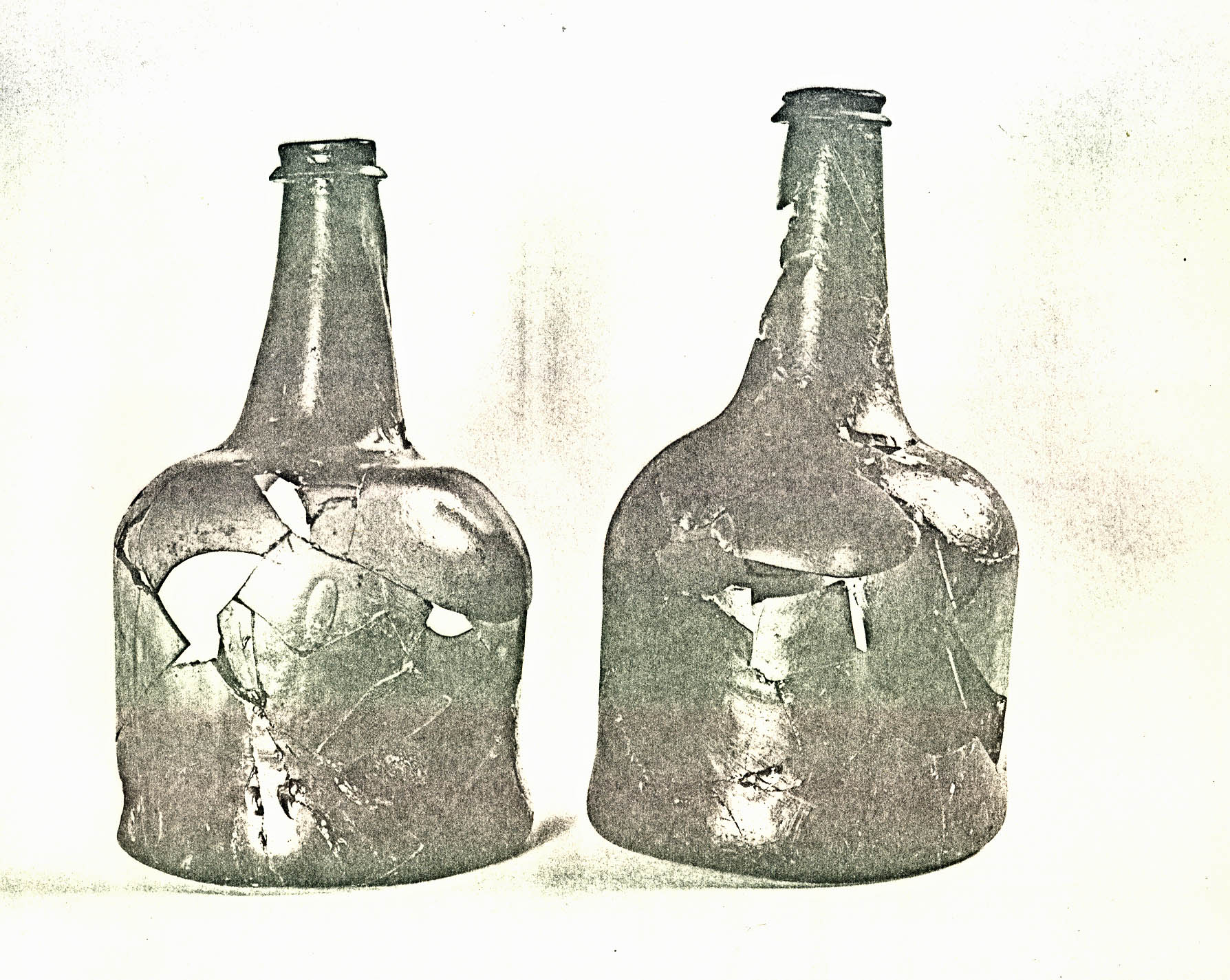 FIGURE 17
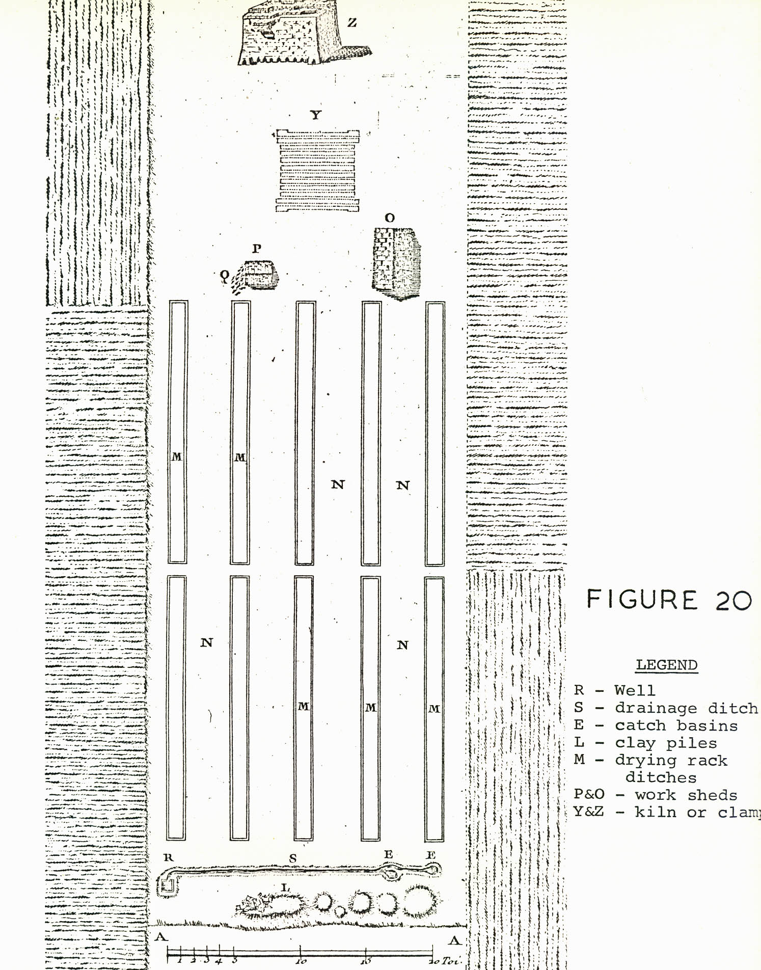 Plate XLI. — Typical 18th century compass brick-lined well shaft but this type of construction was only used in the bottom 6' 10" of Well B. (71 BH 880)
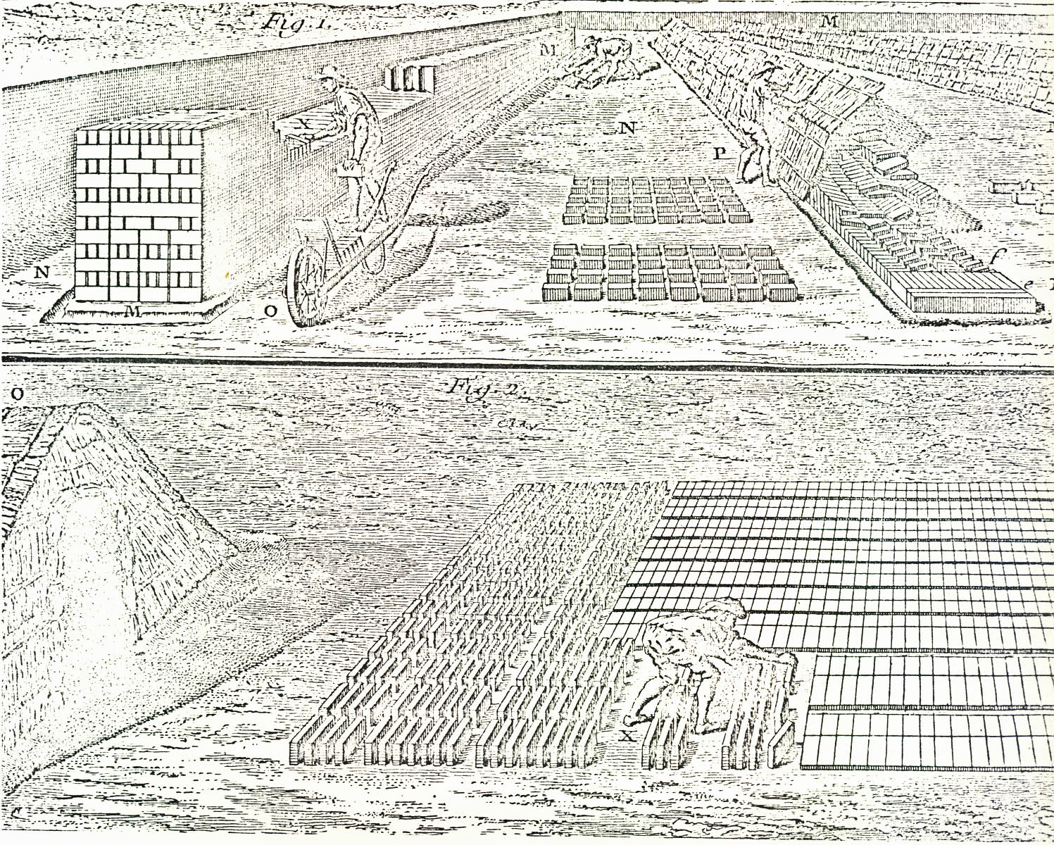 Plate XLII. — Five compass bricks wedged vertically behind Well B's lining which left little doubt that the curbing was constructed from the bottom of the shaft. Photographed from the west. (71-BH-881)
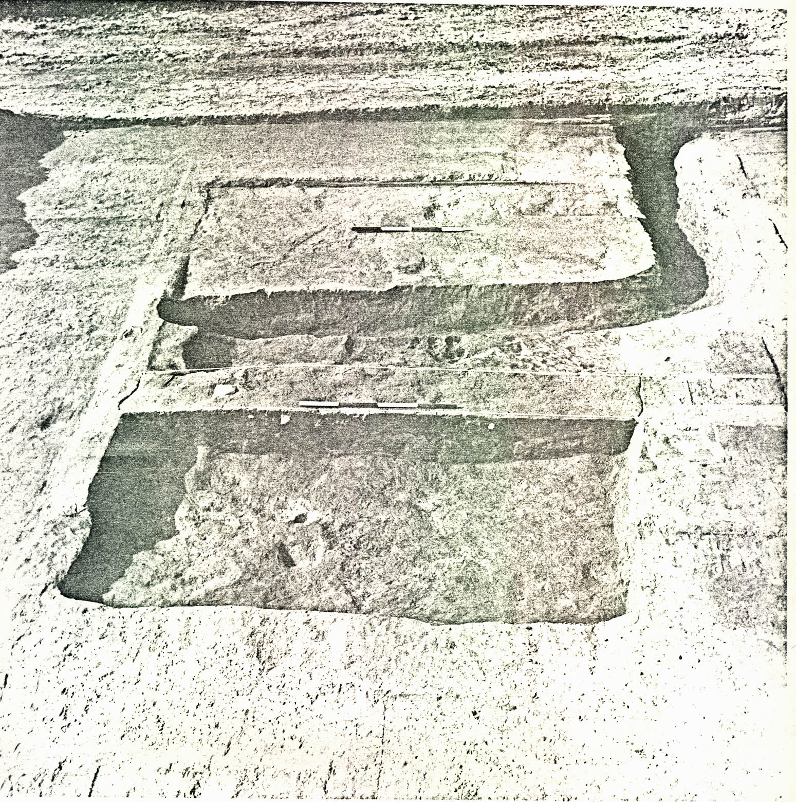 Plate XLIII. — Crudely constructed wooden curb found beneath the last course of bricks in Well B. It consisted of four shaped boards fastened together by nails. The two at the left and right overlapped those at the top and bottom. 71-BH-879
57.
determine how long the well had been in use. The initial deposit began near the bottom of the wooden ring and sloped to a maximum depth of 35'7" (below the natural grade) in the center.
Plate XLIII. — Crudely constructed wooden curb found beneath the last course of bricks in Well B. It consisted of four shaped boards fastened together by nails. The two at the left and right overlapped those at the top and bottom. 71-BH-879
57.
determine how long the well had been in use. The initial deposit began near the bottom of the wooden ring and sloped to a maximum depth of 35'7" (below the natural grade) in the center.
Directly above the initial filling was a 6'9" thick deposit of silty gray clay with occasional brick fragments (CG 1111H & J). The artifacts recovered from this layer (28'0" to 34'9" below natural grade) were far more plentiful and informative than any others encountered in the well. Included in the assemblage were no fewer than 21 identifiable rabbit skeletons, along with the remains of several other small animals (see Appendix VIII for a complete listing). The fact that entire skeletons were found seems to imply that they do not represent the scraps from a colonial meal. Indeed, it would appear more likely that the animals were accidentally killed by drowning after falling down the open shaft. Of course, this would not be possible if the hole had been equipped with a conventional wellhead, but an extant drawing (See Figure 18), depicting an eighteenth-century brickmaking operation, shows a well with no lining above ground level.26 According to eighteenth-century practice, when a site was to have several "furnaces", the well would be lined with masonry "to avoid excessive upkeep".27
The iron objects recovered from this same deposit included a hoe blade with the initials "W K" stamped three times near the end of the rib (See plate XLIV); an axe blade with the maker's mark "W. DEAS" also stamped three times (See Plate XLV); and a 8'4" chain, perhaps from the well bucket, which had a hook at
FIGURE 18 — 18th-century working sketch of a brickyard showing the clay preparation and molding sections (see Footnote 26 for source).
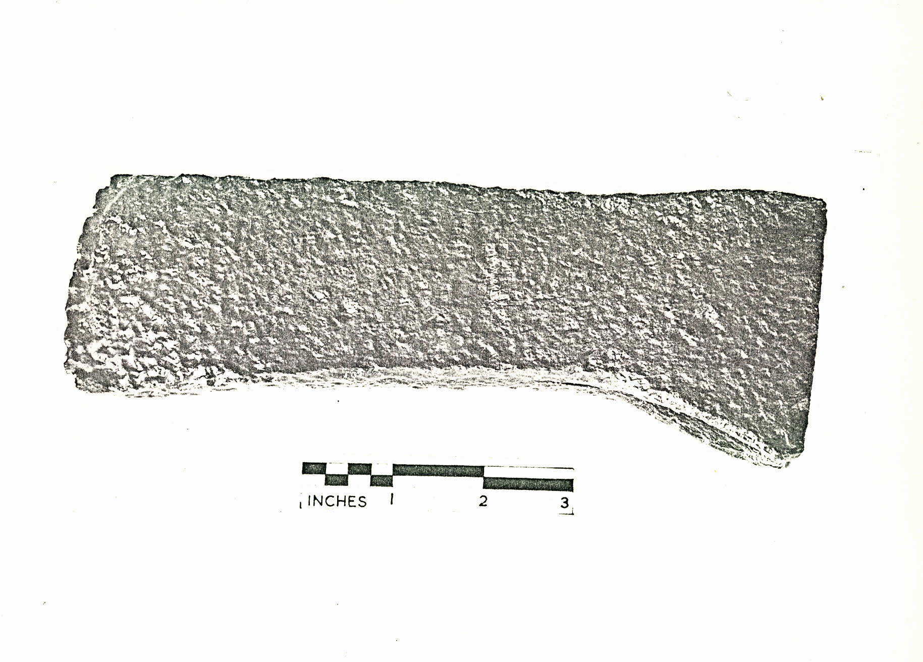 Plate XLIV. — Iron hoe blade with the maker's mark "WK" stamped three times near the end of the rib. This object was recovered from a deposit of silty gray clay (CG 1111J) at a depth of 32' 6" below natural grade in Well B. 71-INH-787
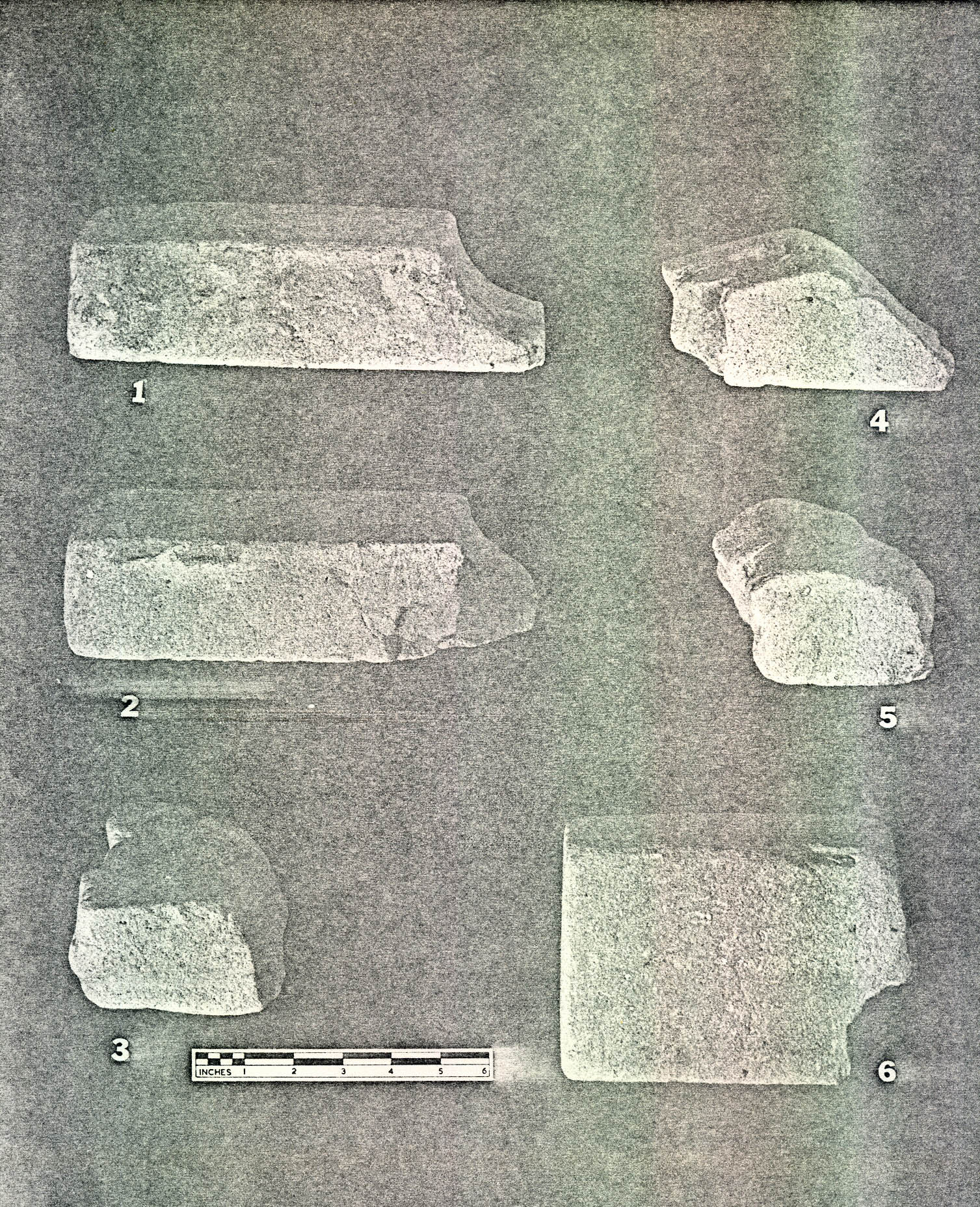 Plate XLV. — Iron axe blade with the maker's mark "W. DEAS" stamped three times near the center. On the opposite side, there is a heart-shaped emblem with an A (G or C) embossed within it. 71-INH-792
58.
one end, a swivel near the center, and a 31/2" diameter ring at the other end.
Plate XLV. — Iron axe blade with the maker's mark "W. DEAS" stamped three times near the center. On the opposite side, there is a heart-shaped emblem with an A (G or C) embossed within it. 71-INH-792
58.
one end, a swivel near the center, and a 31/2" diameter ring at the other end.
Unfortunately, no pottery fragments were discovered in the silty gray clay, but the digging did produce pieces of 6 wine bottles from the period c.1740-55 (See Plate XLVI). This find was most important because it provided a terminus post quem
for the well's abandonment. A clay marble and a bowl piece from a clay tobacco pipe were also recovered from this level. Of particular interest to the landscape architects was the evidence of plant life. The collection of seeds included at least 171 persimmon, 2 pomegranate, 2 peach, 4 black gum, 1 cherry laurel, and a hickory nut fragment, along with twigs from mulberry and loblolly pine trees and a vine section from a wild grape.
The wooden objects (see Figure 19) from this same level (28'0" - 34'9" below natural grade) were most intriguing but are, at present, unidentified as to use or purpose. These included a 2'5" rough yellow poplar log, pointed at one end, with a 1" x 5" finished projection at the other, which may have been intended to support a sill (1); a windlass-like object fashioned from locust, 5'7" long with a fractured tongue on one end, a lathed section 7½" long by 3" in diameter some 1'3¼ from the tongued terminal, and a 2½" x 3" oval hole located 1'3" from the opposite end (2). Also recovered was an oak board beveled at both ends (measuring 2'½" in length, 2-3/8" wide and the width tapering from 3-7/8" to 2½") with a 4½" x 1½" rectangular slot cut into it 4" from one end and a 1¼" hole
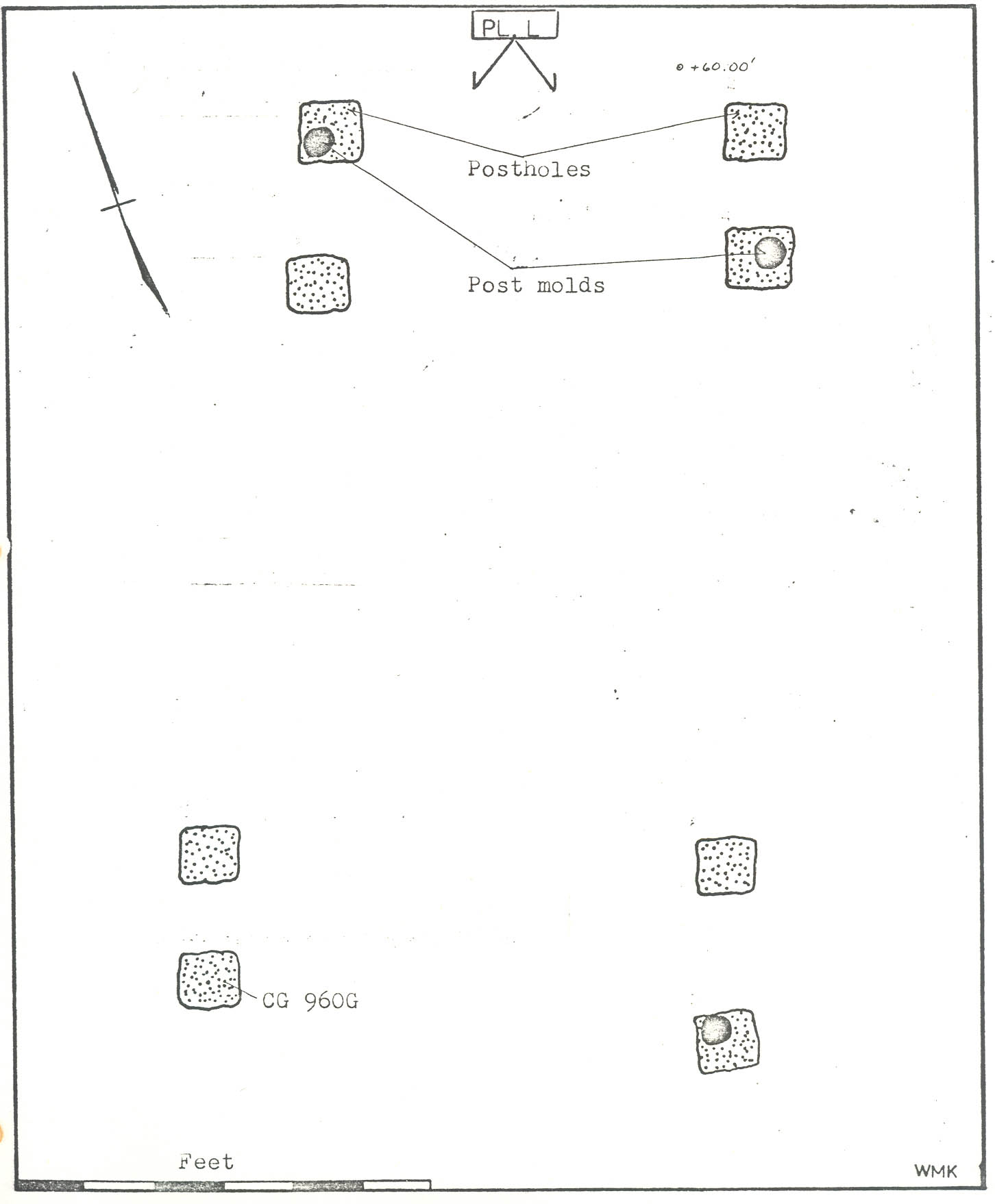 FIGURE 19
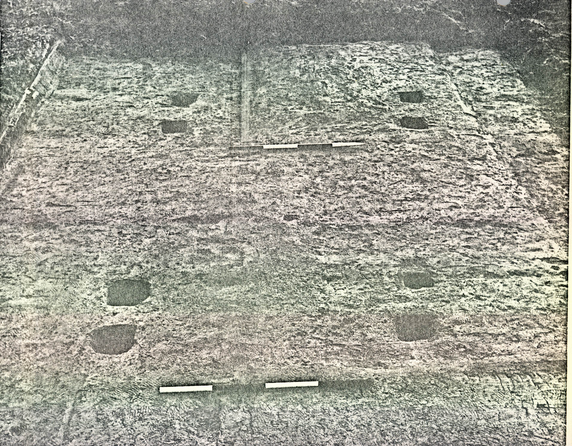 Plate XLVI. — Wine bottles of the period ca. 1740-55 (CG 1111J, left and CG 1091C, 1111J, right) which provided dating evidence for the brickyard. (72 NJI 270)
59.
(retaining a portion of doweling) located 5" from the other (3). The deposit also yielded two 1-1/16" thick boards which had apparently been part of the same construction since the nail holes in both were on line (4) and an oak log 4'1", in length by 6" in diameter which had a flat surface (5). There were also several pieces of pine which showed evidence of having been bored into by insects.
Plate XLVI. — Wine bottles of the period ca. 1740-55 (CG 1111J, left and CG 1091C, 1111J, right) which provided dating evidence for the brickyard. (72 NJI 270)
59.
(retaining a portion of doweling) located 5" from the other (3). The deposit also yielded two 1-1/16" thick boards which had apparently been part of the same construction since the nail holes in both were on line (4) and an oak log 4'1", in length by 6" in diameter which had a flat surface (5). There were also several pieces of pine which showed evidence of having been bored into by insects.
The well's upper filling (0" to 28'0" below natural grade) consisted almost entirely of broken bricks (presumably the debris from the manufacturing activity in the area) with average widths of 4¼" and thickness of 2½". The longest fragment encountered was 5". The artifacts from this deposit were far from plentiful and were relatively unimpressive. At a depth of 10'8" several pieces of very thin iron were found and lower (14'0" to 16'0") a wine bottle base of the period c.1740-55 was encountered. The only fragment of pottery from the shaft was recovered at a depth of from 16'0" to 18'0" below the natural grade. It was a pan sherd made of Yorktown lead-glazed earthenware and, since the fractured edges showed signs of having been glazed, the object must have been broken and its pieces left either in or near a kiln. The other interesting finds in the upper filling were five long, tapering poles (the longest being 10'7½") of uncertain purpose, but perhaps waste from rail splitting.
d. Small Pits
Four smaller and deeper circular pits were uncovered to the east of Pit A (CG 1091), two of which contained mixed clay fill with brickbats and water-worn cobblestones at or near the bottom (CG 1196, CG 1198). The function of these pits is also uncertain.
e. Interpretation
There is considerable historical evidence concerning brickyards which aids the interpretation of the archaeological features found at Carter's Grove, (Figures 18, 20, and 21) show the plan and two working sketches of an eighteenth-century brickyard which includes: a clay mixing area at one end of the site complete with a well without a wellhead (R) and a ditch (S) to carry water from the well to catch basins or pits (E) from which water was thrown onto piles of clay (L) for mixing with hoes. Well B (CG 1111), with its two ditches leading to Pit A (basin?) found by archaeology at Carter's Grove generally follows this same plan27 (See footnote 26).
The eighteenth-century plan and sketches also show a system of narrow ditches (M), rectangular in plan, located toward the center of the site. Here bricks were stacked and covered to dry, the ditches serving to carry rain water away from the bottom brick courses. The kiln or clamp is located at the end of the site, opposite the well and mixing area.
As mentioned above, parallel ditches were found associated lines of postholes with Clamp 3 and Clamp 5. Also, lines of postholes
FIGURE 20 — 18th-century French brickyard (see Footnote 26 for source).
61.
between and along the outside of the ditches suggest that a crude gabled or A-frame structure stood over the areas between the ditches, perhaps more permanent form of shelter than the mats shown in Figure 21. However, the presence of the charred central posts and the burnt clay between the ditches at Carter's Grove shows that the bricks were also fired in the ditch area, which does not parallel the eighteenth-century plan. Perhaps both the drying, then later the firing process took place on the same spot at Carter's Grove. This would have been economical in that only one set of ditches and covers would have been necessary for both drying racks and clamps. Or perhaps the drying racks were located on the elevated area between Clamp 2 and Clamp 3 where the natural crown of the field and shallow ditches(?) would have carried off rain water and where plowing and erosion would have had a better chance to obliterate all the archaeological evidence.
Eighteenth-century clamps, built directly on the ground surface, are described in Neve's Builder's Dictionary (1736 edition) as follows:
They build their Clamps of the Bricks that are to be burnt something like the Method of Building the Arches in Kilns, viz. with a Vacancy betwixt each Brick's Breadth, &c. for the Fire to ascend by; but with this Difference, that instead of Arching, they truss, or span it over, by making the Bricks project one beyond the other, on both sides of the Place,
The clamps at Carter's Grove, as mentioned above, must have had covers for protection from the rain. Moreover, the archaeological evidence suggests that the central poles supporting the roof ridge must have been left in place during firing, thus producing a central line of charred posts in the process. The side posts supporting the shelter eaves(?) would have been easily removed and salvaged before firing (thus leaving only empty postholes). But after the clamp bricks had been stacked around the central supporting posts, it probably was not worth the effort to remove them before the bricks were burned. It is possible that the tapered poles found in the fill of Well B had been used in the construction of the clamp shelters (See page 59 ).
The Burwell Account book shows that bricks were being "burned" at Carter's Grove as early as 1744 by a Negro Lot and again in 1749 by David Minetree.29 However, in 1750, 63. Burwell purchased some 460,000 bricks, 100,000 of these from Mann Page.30 Thus, it appears that the bricks used in the buildings at Carter's Grove came from two sources; i.e., those made on the site and those made elsewhere. The bricks used in the mansion at Carter's Grove (at least on the exterior) are distinctly purplish-pink in color, contain a considerable amount of quartz pebbles and none of the headers are glazed. On the other hand, the bricks found in the area of the brickyard site and in the filling of Well B (CG 1111) are generally orange or red in color, some were glazed and they contain little or no quartz pebbles. This brick type essentially matches the bricks used in the kitchen and office wings flanking the mansion. Therefore, based on brick types, there is reason to believe that the bricks used to construct the earlier kitchen and office wings of the mansion were those burned at the Carter's Grove brickyard, perhaps by Lot in 1744 or by Minetree in 1749, while the bricks used on the facade of the mansion were those purchased in 1750.
3. Other Features Possibly Related to Crafts
The removal of the plow zone in Field 14 (Foldout Figure 25) revealed three features of probable eighteenth-century date, possibly related to craft activity. A square shallow pit with a drainage ditch at one end, another ditch containing some unusual bricks, and a feature consisting of eight postholes were found.
a. CG 940, The Square-Ditched Feature
The largest eighteenth-century feature, CG 940, (See Figure 25 and Plate XLVII) at first had the appearance of a backfilled cellar hole (13'0" x 13'0") Subsequent excavation, however, showed the feature to be only 1' 0", deep, probably never having been any deeper than 2' 6" below the surface. A ditch was found running along the west edge of the feature (See Figure 22). It continued 15' 0" north, made a 90° turn to the west and ran 75' 0" to the edge of a slope in Field 13.
The stratigraphy indicates that the square feature and the ditch were open, then backfilled at the same time. Both were filled with a layer of mixed grey and brown clay (CG 940B) and a layer of brown loam containing brickbats and brick dust (CG 940A&C). Apparently the bottom of the square feature had been dug so that it would drain into the ditch, and lenses of what appeared to be rust (CG 940J) were found on the bottom of both the square feature and the ditch. In the south end of the ditch, a concentration of brickbats and brick dust was found immediately below the plow zone (CG 940C).
The artifacts found in the brick layer (CG 940C), consisting of fragmented wine bottles of 1740-60 date, a foot ring from a plain white saltglazed stoneware saucer probably of mid eighteenth-century date, a barrel band and
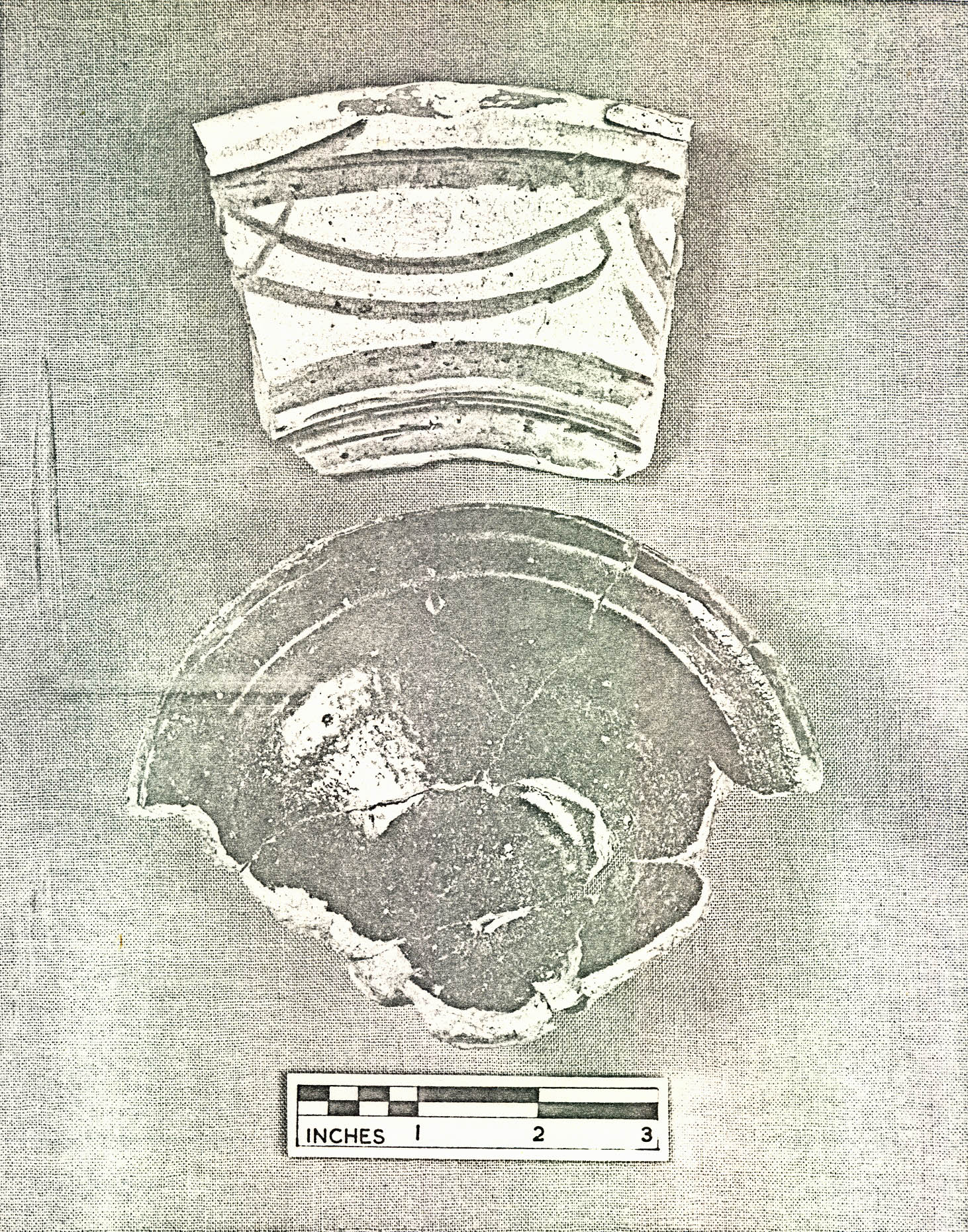 FIGURE 22 — Plan of Feature CG 940, Field 14. (See also Figure 25 and Plate XLVII)
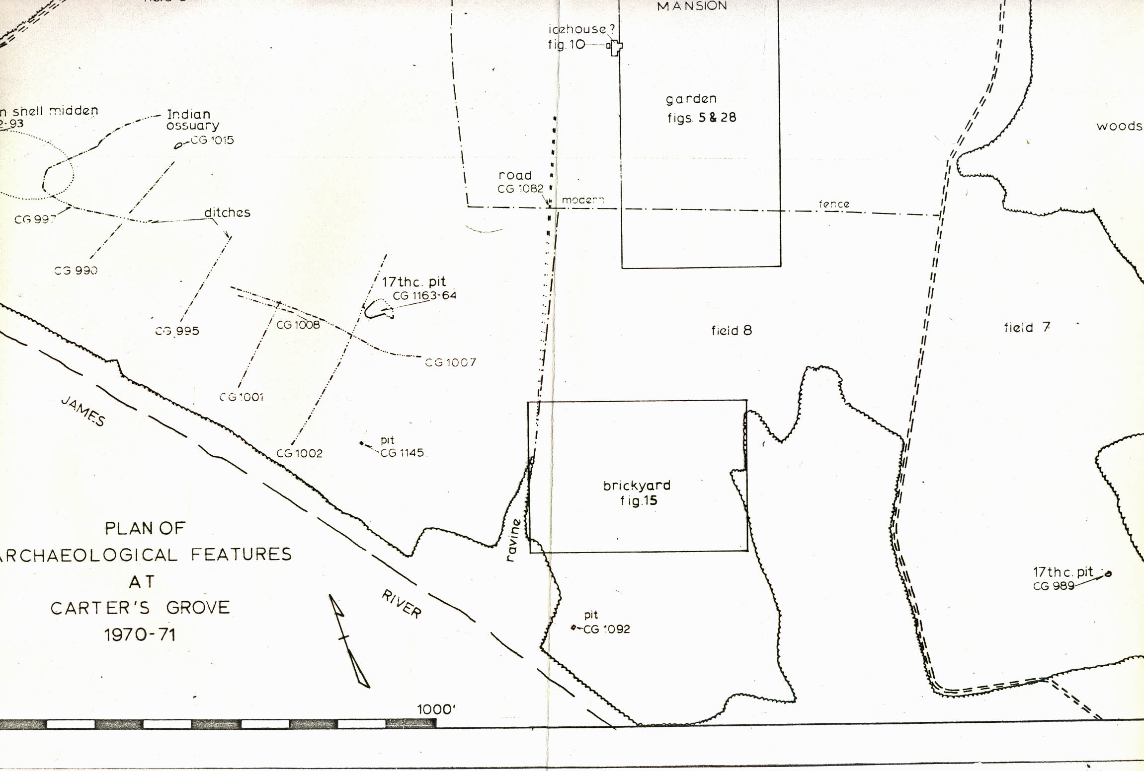 Plate XLVII. — View from the east of feature CG 940 field 14 showing square pit (with balk retained through center) and right angled drainage ditch (center and background) (See also Fig. 25 for location and Fig. 22 for photo angle). (72 INH 923)
65.
a mortising axe (See Plate XLVIII) date the backfilling of the square feature and the ditch sometime after c. 1750. No artifacts were recovered in the lower level or on the clay floor surface. Occasional pieces of what appeared to be decayed bark were found in the gray clay fill.
Plate XLVII. — View from the east of feature CG 940 field 14 showing square pit (with balk retained through center) and right angled drainage ditch (center and background) (See also Fig. 25 for location and Fig. 22 for photo angle). (72 INH 923)
65.
a mortising axe (See Plate XLVIII) date the backfilling of the square feature and the ditch sometime after c. 1750. No artifacts were recovered in the lower level or on the clay floor surface. Occasional pieces of what appeared to be decayed bark were found in the gray clay fill.
The shape and uniform sides of the square feature suggest that it could have been inside a structure. If so, the absence of postholes around the edges suggests a structure built on sills laid directly on the ground surface. What such a square structure (if indeed it was a structure) with its drainage ditch could have been used for is uncertain. It is possible that the feature was used as part of leather curing or tanning operations with the ditch serving as its drain. The "rust" stains could actually be tannin deposits. Whatever its function, however, there is a good possibility that the backfilling layer containing the brick could have come from the construction of the mansion. It is almost certain that similar fill found nearby in another eighteenth-century feature (CG 980) came from the mansion construction.
b. Feature CG 980
A 7' 0" x 4' 0" rectangular feature (CG 980), also with a small ditch at one end, was found 50' 0" southeast of CG 940 (See Figure 25). In profile, the feature looked like an irregular
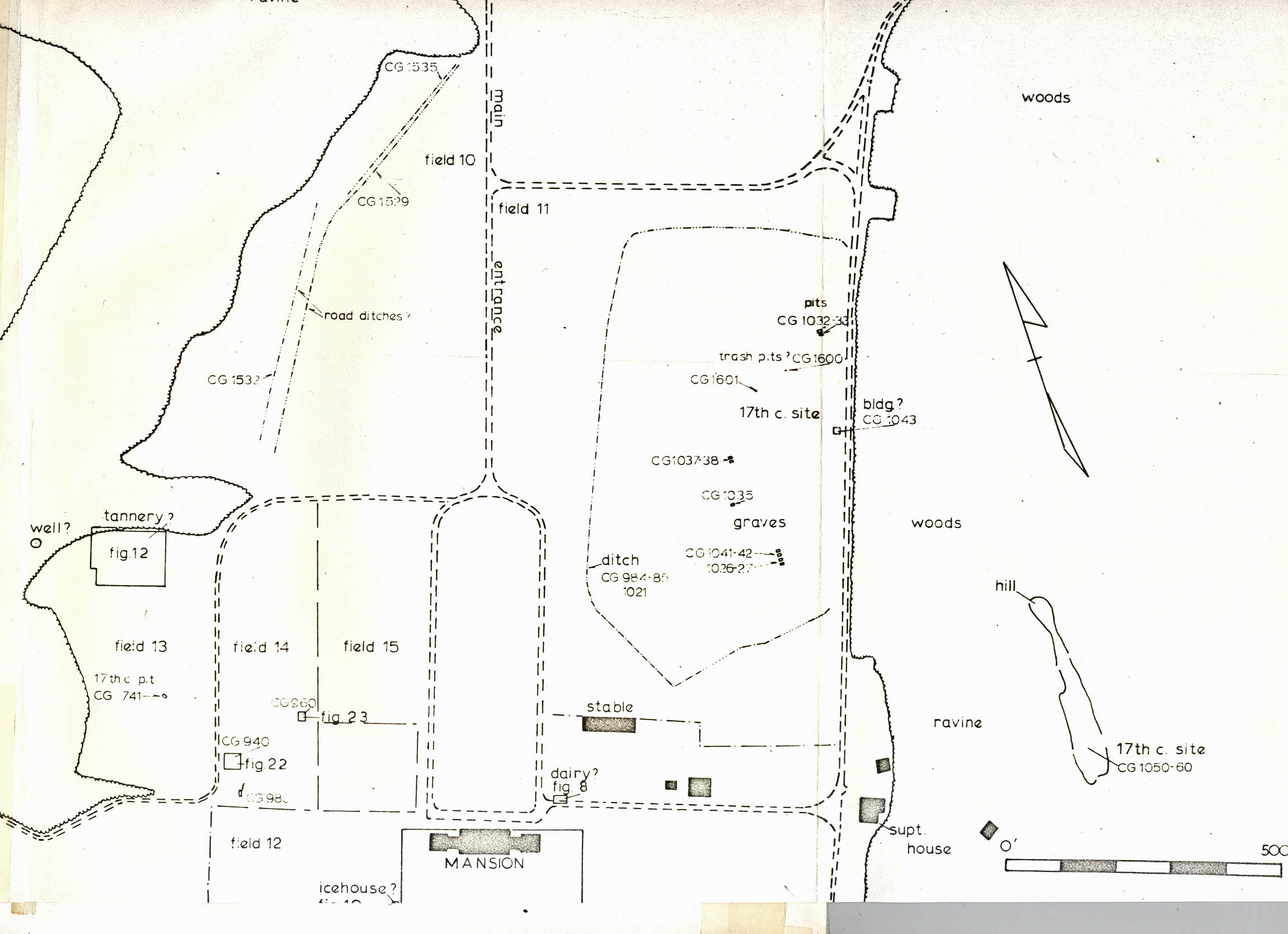 Plate XLVIII. — Mortising axe (CG 940C) found in the fill of feature CG 940. Note: "T" shaped maker's mark (letters did not survive). (72 NJI 278)
66.
pit or ditch with sloping sides. The feature had been dug 2' 6" below the surface of the subsoil in the center. Weather conditions and modern intrusions negated tracing the feature any further to the south.
Plate XLVIII. — Mortising axe (CG 940C) found in the fill of feature CG 940. Note: "T" shaped maker's mark (letters did not survive). (72 NJI 278)
66.
pit or ditch with sloping sides. The feature had been dug 2' 6" below the surface of the subsoil in the center. Weather conditions and modern intrusions negated tracing the feature any further to the south.
Like CG 940, CG 980 had been backfilled with brown loam containing brick and brick dust. Fragmented wine bottles were found in the fill suggesting a post 1750 deposition date. Therefore, it is probable that CG 940 and CG 980 had a related function (stood open at the same time) and/or they at least had been backfilled at the same time with material coming from the same place.
The bricks in the fill in CG 980 indicate that they had come from the construction of the mansion. Water table bricks (CG 980A) (See Plate XLIX), identical in shape to those used in constructing the water table courses in the mansion, were found along with other rubbed bricks, presumably for use in window arches. These bricks were the same color as the brickbats and dust found in the fill of CG 940. However, since brick was found only in the backfilling material of each feature, it is probable that they have no relationship to the function of the features. At any rate, rubbed bricks, a mortising axe (found in CG 940) and wine bottles all could be part of debris left over from construction, and their deposition date in the 1750's corresponds to the construction of the mansion.31
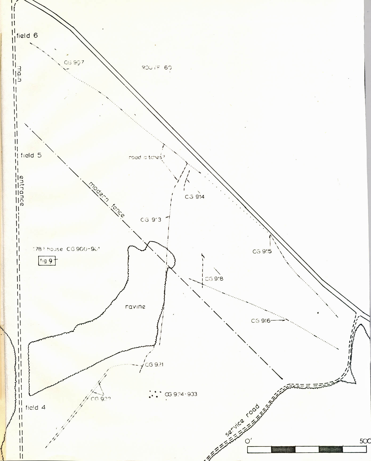 Plate XLIX. — Examples of molded and/or rubbed water table (1-4) and (5) arch bricks (CG 980A) matching those used in the mansion found in the fill of feature CG 980, field 14. Note: brick with corner sawed away (6). (72 NJI 1330-1331)
c. CG 960, Eight Posthole Structure(?)
Eight square postholes were found on the central eastern edge of Field 14, ranging in depth from 1'6" to 2'2". (See Figures 23 and 25 and Plate L). They were arranged symmetrically and had apparently supported round posts 4" in diameter. One hand wrought nail (CG 960) was recovered in the posthole fill, suggesting the possibility that the feature dates in the colonial period; but all other evidence lacking, it is impossible to determine form or function.
D. Seventeenth-Century Features
Considerable evidence of seventeenth-century occupation was found at Carter's Grove during the course of the exploratory excavations. Machine cross-trenching, hand testing, and surface collecting located seventeenth-century features in Fields 7, 8, 9 and 11, and systematic testing by hand in the wooded area 400' east of the superintendent's house uncovered evidence of one area of seventeenth-century occupation. The features were only tested enough to enable an approximate date determination; therefore, the function of each feature must, for the present, remain speculatory.
1. Field 7
A backfilled hole, perhaps a clay pit (CG989), measuring 14'6" x 10'10" was found and partially excavated in the southeast corner of Field 7 (See Figure 24). The significant artifacts from the pit fill consisted of a pipe bowl (CG 989A), 1620-1660, (See Plate LI, left); a hexagonal base from a delft salt of probable mid seventeenth-century date (CG 989A) (See Plate LII, top); a seventeenth-century English delft plate sherd (CG 989A) (See Plate LII, bottom); and, a sherd from a sgrafitto gravel tempered platter made in North Devon after 165032 (See Plate LIII).
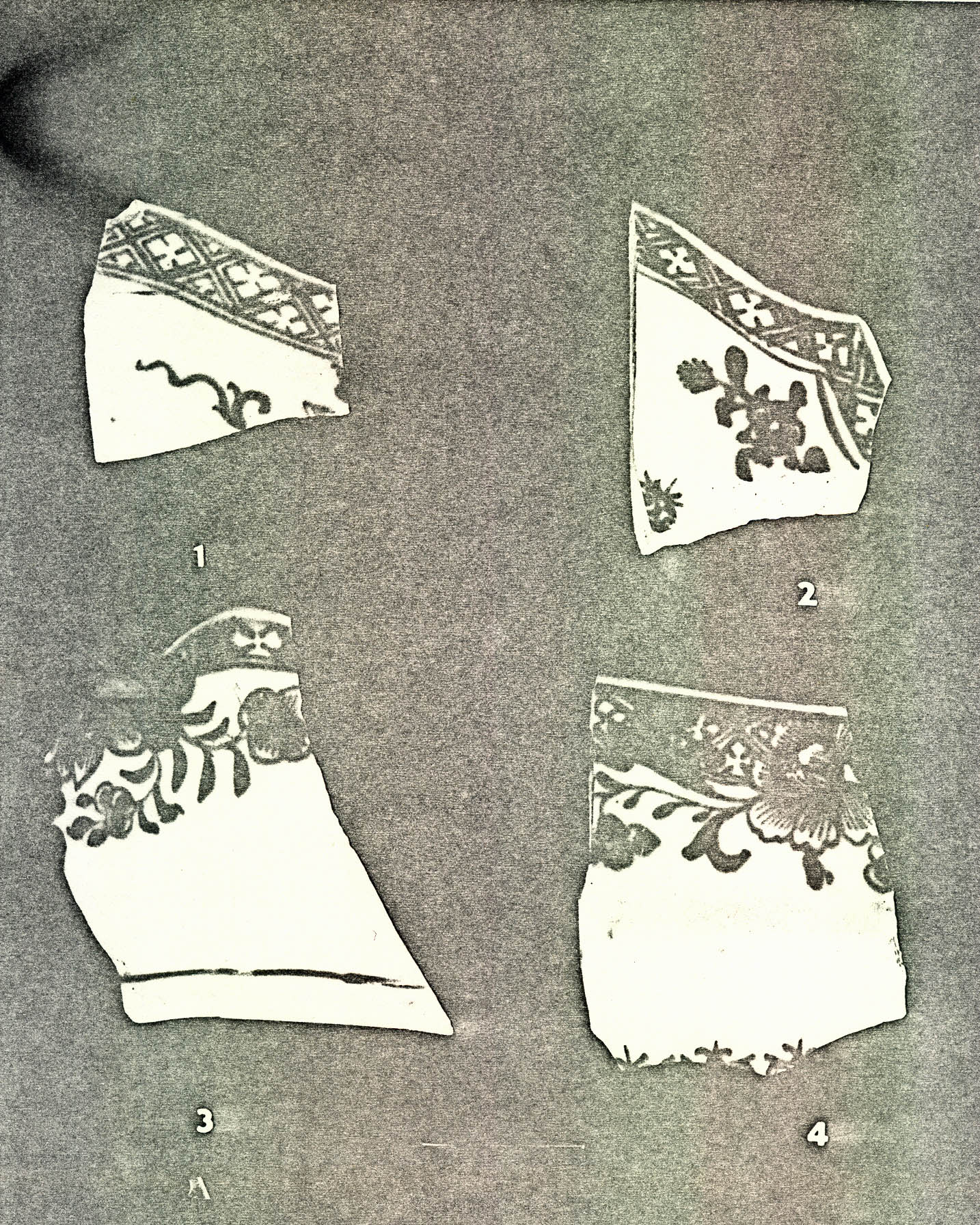 FIGURE 23 — Plan of Feature CG 960, Field 14.
 Plate L. — View from the north of feature CG 960 in field 14 showing symmetrical arrangement of eight postholes. (See also Fig. 25 for location and Fig. 23 photo angle). (72 INH 924)
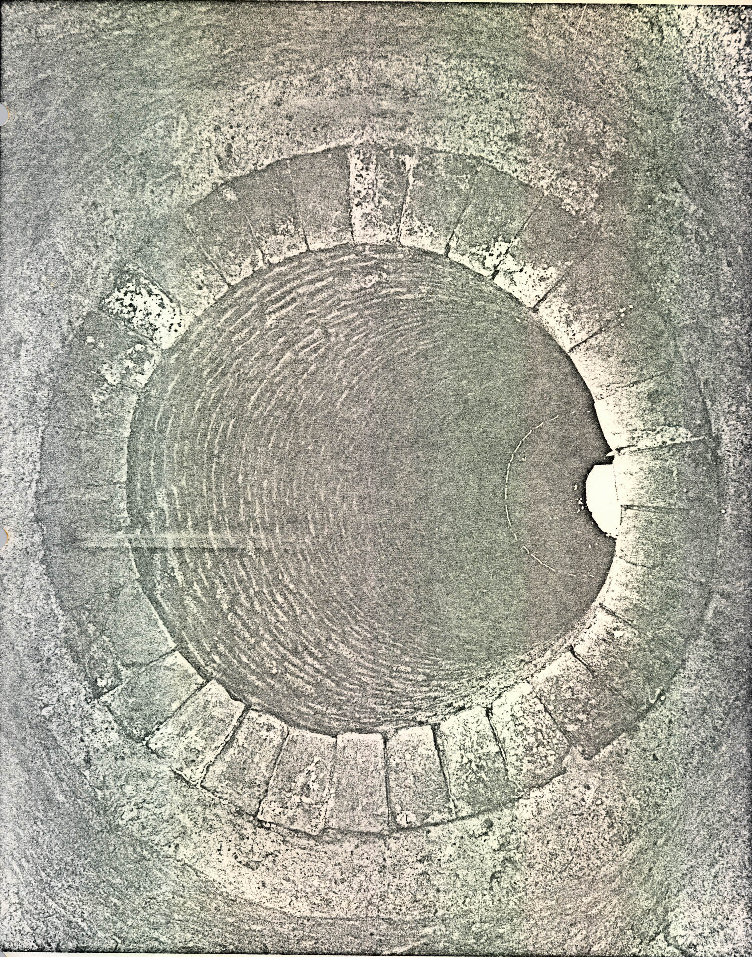 Plate LI. — Typical clay tobacco pipe bowls, ca. 1620-60 found in association with seventeenth century features. (1) CG 989A, trash pit field 7, (2) CG 1601 "TG" initials molded on base of heel, (3) CG 1601 made of local (?) red clay, field 11. (72 NJI 285)
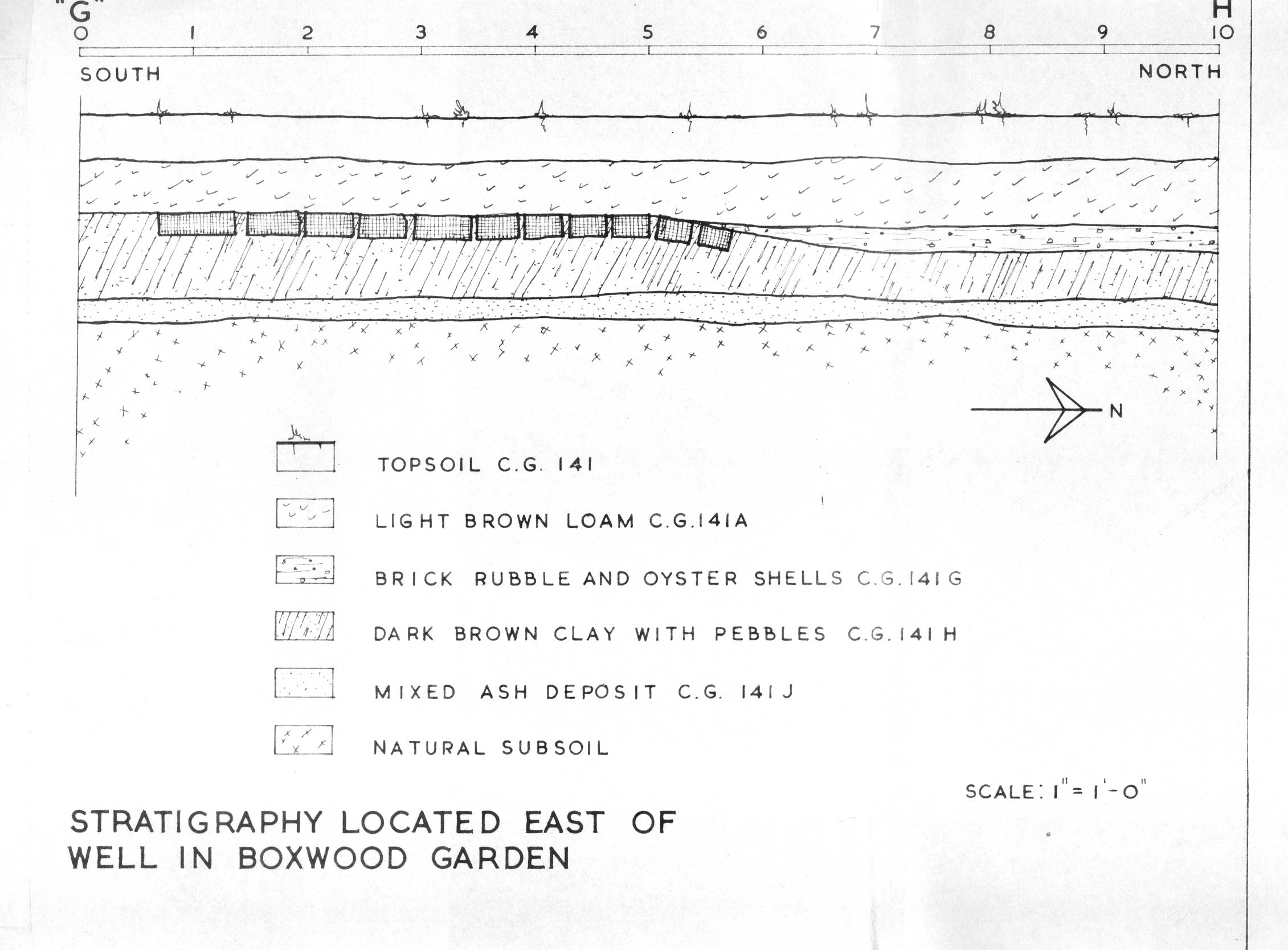 Plate LII. — Hexagonal delft salt base (CG 989A) (top) and blue on white delft plate sherd (CG 989A) (bottom) from trash deposit (CG 989) found in field 7, filled after ca. 1650. (72 NJI 276)
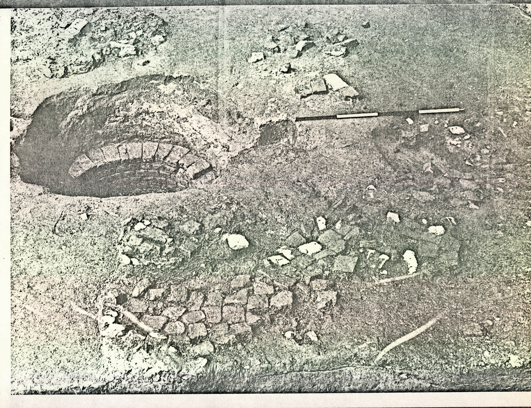 Plate LIII. — North Devon sgrafitto yellow and brown dish sherd made after ca. 1650 from trash deposit, field 7 (top, CG 989A) and lipped coarse earthenware bowl with red body and dark brown lead glaze from trash pit (CG 1145), field 9 (seventeenth century). (72 NJI 265)
2. Field 8
A rectangular pit (3' 1" x 6", 3' 2" deep) (CG 1092) was found in Field 8 (See Figure 24) 300' 0" south of the mansion. It contained musket balls (CG 1092A, B), a sherd of brown stoneware and the remains of what appeared to be tree branches. It is possible that this feature had been used for a hunting blind sometime in the seventeenth century.
3. Field 9
A trash pit (CG 1145) and a large backfilled hole (CG 1163, CG 1164) measuring at least 23' 6" x 30' (?) (possibly a backfilled cellar hole) were uncovered by mechanical trenching in Field 9 about 1000' 0" southwest of the mansion (See Figure 24). The artifacts from the plow zone and from the surface of the features suggest a mid seventeenth-century date for the backfilling (See Plate LIII, bottom). Also, a system of ditches was found (CG 990, 995, 997, 1001, 1002, 1007, 1008) ranging from 2'0" - 5'0" wide, 9" - 1' 6" deep, running around the high ground in the field and northeast-southwest at about 170' 0" - 230' 0" intervals down the slope toward the river. Nails found in one of the ditches (CG 1007) suggest that they date from the colonial period, but whether or not they are associated with the seventeenth-century occupation is uncertain.
4. Field 11
Surface surveying and machine trenching located a possible 69. structure site, four(?) pits, and a large ditch in Field 11 (See Figure 25) about 900' northeast of the mansion. One feature (CG 1043), a rectangular deposit of charred wood (12' 0" x (?)), could well be the remains of a burned structure. Pipe stems found on the surface of the feature suggest a mid seventeenth-century date for the fire. 180' 0" to the northwest two other features were found, consisting of a rectangular backfilled hole 5' 0" x 8' 0" (CG 1032) next to a round backfilled hole, 4' 8" (CG 1033) in diameter. The artifacts found in the area and on the top of the deposits date the backfilling also to the mid seventeenth-century period. Also, two(?) trash pits (CG 1600, CG 1601) were located 150' 0" northwest of CG 1043 by the discovery of artifacts in the spoil of two groundhog burrows. Two English clay tobacco pipe bowls from the spoil (CG 1601) date the deposit to about 1620-1660 (See Plate LI, center, right).
Seven graves (CG 1026, 1027, 1035, 1037, 1038, 1041, 1042) were found 150' 0" to the south of the seventeenth-century features. Each had been laid out on an east-west compass axis in rectangular holes about 3' 0" x 6' 0". None of the burials were excavated; therefore, their date of interment could not be determined. Bone protruded from CG 1027 at 1' 6" below the modern grade.
All of the above mentioned features and about eight acres of Field 11 were surrounded by a substantial ditch 3'4" to 5'0" across and from 2'2" to 3'4" deep (CG 984, CG 985, 70. CG1021). Its plan, laid out in a rough pentagon shape, suggests that the ditch was part of a defense system protecting the seventeenth-century settlement within. Handmade nails date the ditch to the Colonial Period.
5. Field 13 —
About 200' 3" southeast of the rectangular pit area in Field 13 (See Figure 25) an irregular hole (2' 8" x 6' 0", 2' 0" deep) was found containing artifacts of about mid seventeenth-century date (CG 741A). The irregular shape, the sloping walls and the artifacts indicate that the feature was nothing more than a trash pit. There is apparently no relationship between this pit and the tannery(?) at the north end of the field.
6. Wooded Hill Occupation
Occupation layers of seventeenth-century date (CG 1050-1060) were found by testing on a hill in the woods 400' 0" east of the superintendent's house (See Figure 25). It encompassed an area approximately 50' 0" x 50' 0". The datable artifacts, consisting of North Devon sgraffitoware, tobacco pipe stems, and a jetton made by Hans Crauwinckel, Nurenberg [c.1580-1610(?)] suggest a mid seventeenth-century occupation date.
E. Indian Site — Field 9
Considerable evidence of prehistoric Indian occupation was found in Field 9 (See Figure 24). A shell midden layer (CG 992, CG 993) and a multiple burial ossuary (CG 1015) were located by machine cross-trenching. Subsequently, Dr. Norman Barka of The College of William and Mary was called in to test the site. A summary of his finding (below) was submitted April 8, 1971:
During the week of April 12-16, 1971, the Department of Anthropology tested the high ridge of the field (Field NO. 9) west of the main house at Carter's Grove. The purpose of this archaeological work was outlined in my letter to you of January 28, 1971.
Our findings were as follows:
- 1)in the area of the field to the east of the 18th century graves, we found no indications of an Indian occupation zone or Indian features in the subsoil. However, several late 17th-early 18th century soil stains were located, which were mapped but left undisturbed. The subsoil in this area occurs at a depth of only 0.7 ft. beneath ground surface. Plowing has destroyed any Indian layers that might have been present.
- 2)
the human burial area (CG 1015) found by Mr. Kelso was investigated. A 10ft. square was opened to subsoil level immediately east of CG 1015. Very subtle soil discolorations were noticeable, and on further investigation in a 6 ft. x 6 ft. area within the square, 9 or 10 closely-spaced Indian secondary or bundle burials were found.
This burial area, of which CG 1015 is a part, represents an Indian ossuary, possibly a very large one, and probably dating somewhere in the 350-1600 A.D. period. To my knowledge, this represents the first Indian ossuary found on the James River and is thus a very important discovery to prehistoric archaeology.
FIGURE 24
FIGURE 25
FIGURE 26
- 72.
- 3)the area of the field west of CG 1015, which had been previously tested by bulldozer, was found to have undisturbed Indian occupation zones between the plow and subsoil. This area probably represents the main living area of the Indian population.
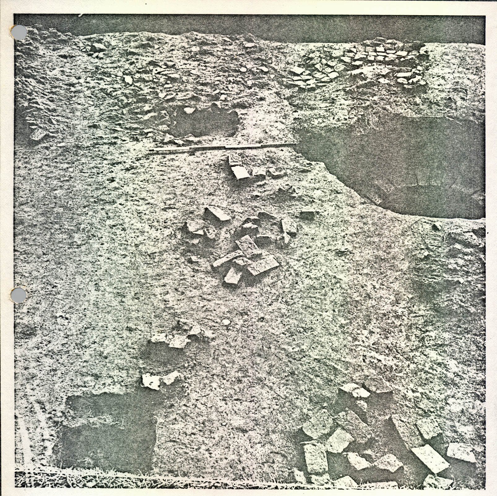
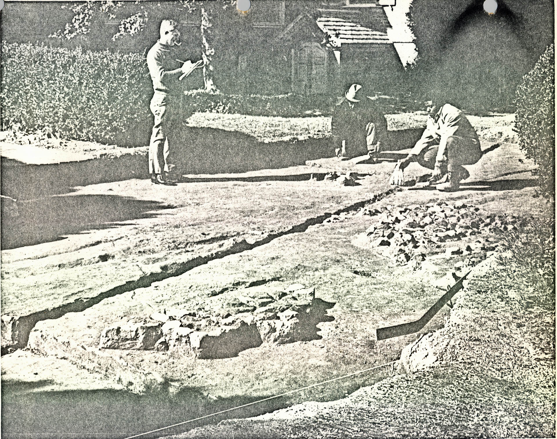
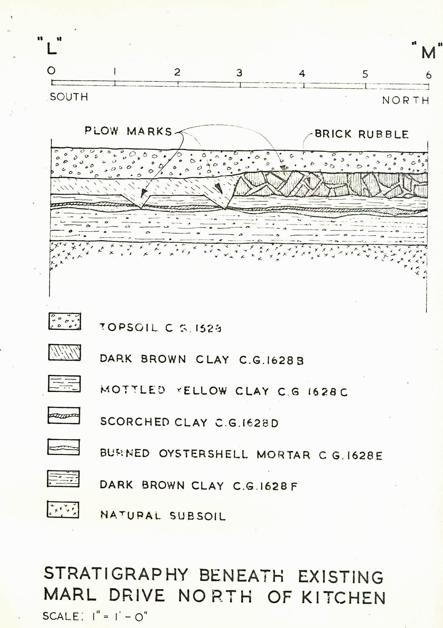
F. Distribution of Colonial Ceramic Sherds in the Vicinity of the Mansion
Six hundred and ninety-four 2'0" x 2'0" test holes were dug during the summer and fall of 1970 in the immediate vicinity of the mansion. In addition to the 100'0" wide strip just north of the mansion, both sides of the terrace were tested and numerous test holes were dug around the superintendent's house east of the mansion.
To no one's surprise, as the testing approached the mansion, the amount of colonial ceramics recovered increased (See Figure 27). On the other hand, digging more than 200' 0" east or west of the house produced practically no evidence of Colonial occupation. From this it might be concluded that no complex of substantial eighteenth-century outbuildings ever stood in the usual symmetrical arrangement in the vicinity of the mansion. However, the testing may indicate that scattered buildings of light construction were located within 200' 0" of the mansion, but it would take area excavation to prove it.
During the course of the testing, examples of heavy Chinese porcelain plates were found around the kitchen and house (CG 140A, CG 259A, CG 479A), and a heavy cup of the same general type was found at the foot of the west terrace flank (CG 1525C) (See Plate LIV). They were probably made during the second half of the eighteenth century. This ceramic type may have been typical of the Burwell's fine tableware, and it is possible that a complete service of this type was once used in the mansion.
FIGURE 27 [oversized image]
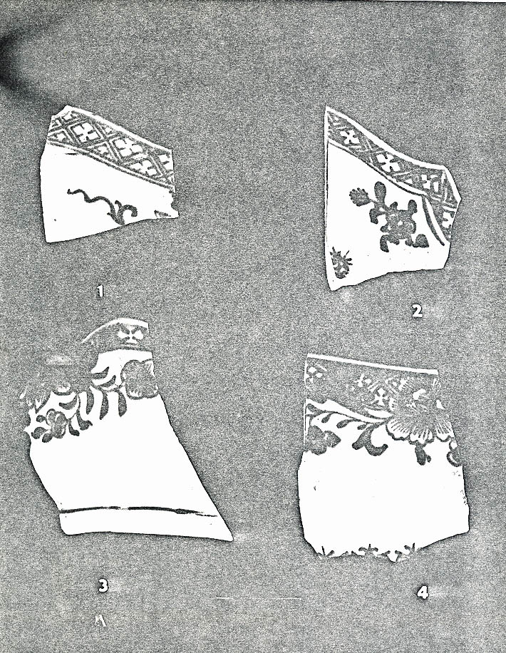 Plate LIV. — Examples of heavy blue under-glazed Chinese Porcelain found during testing around the mansion: (1) plate rim (CG 259A), (2) plate rim (CG 140A), (3) large cup or bowl (CG 1525C)m after ca. 1750. (4) plate or dish rim (CG 479A). (72 NJI 272)
G. Concluding Remarks
As stated above, the primary goal of the excavation at Carter's Grove was to locate remains of outbuildings. Only two were found and, at that, only a floor remained of the eighteenth-century(?) dairy and only the base of the chimney scaffold holes survived of the house extant in 1782. Carter's Grove had outbuildings—several are mentioned or implied in the records. Why were they not found by archaeology? In a negative sense archaeology supplies one answer.
The open land at Carter's Grove has been plowed continuously since the eighteenth century. Archaeological testing showed that the plowing went 1' 3" beneath the modern grade and extended as close as 100' 0" from the mansion. Thus, for all practical purposes, occupation layers or structural evidence located more than 100' 0" from the house have been obliterated, at least to a depth of 1'0".
Now, the important structures — those requiring substantial foundations — still stand at Carter's Grove; i.e., the mansion, kitchen and office. If the rest of the outbuildings; i.e., overseer's house, barn, slave quarters, etc., were of frame construction resting on shallow piers or foundations (and there is every reason to assume they would have been), and if they were located more than 100' 0" from the house (which seems logical considering their function), then it follows that plowing could have erased all evidence of them.
74.The "structural remains" in Field 5, i.e., the 1782 house site (See page 25), are a case in point. If the building had not had chimneys, and if there had been no map showing a structure at that site, and if the structure had not been a dwelling (as the artifacts suggest), then it is probable that after plowing absolutely nothing archaeological would have survived. In other words, the 1782 house site shows that frame barns or slave quarters with only wooden chimneys, etc., located on sites which were subsequently cultivated, could have been erased from detection, particularly if no map existed pinpointing their location. This may have been the fate of the Carter's Grove minor dependencies.
Another possible reason for the lack of success in locating outbuildings may be that some had been located far enough from the mansion to be off the present bounds of the property (400 acres). The bounds of the original 1288 acres are not known. A line can be drawn using topographic features to enclose 1288 acres around Carter's Grove which would include the old Stryker property and house site to the southeast (which includes the ruin of a small eighteenth-century(?) brick structure similar to the kitchen wing of the Carter's Grove mansion) and a considerable tract northeast of modern Route 60. In fact, if the 75. overseer's house or slave quarters were located more than 3600' 0" in any direction from the mansion, then they would have been off the present Carter's Grove tract.
Also, it should be kept in mind that every square foot of the 400 acres (17,640,000 square feet to be exact) was not, nor could not be, excavated. However, with the exception of the northeastern section of Field 9 (See page 8) and the areas showing seventeenth-century occupation in Field 11 (See page 8 ), all "logical" structure sites were either tested or trenched. Buildings with less surviving than the above mentioned 1782 house site (CG 900-901), located between machine trenches or test squares could have escaped detection. But on this score one must consider the ecological and monetary price one must pay for, perhaps, a set of postholes.
Finally, the possibility still exists that future excavations in the undug section of Field 9, the seventeenth-century site in Field 11, the northern and western edge of Field 13, and the trenching of landscaped area around the mansion might locate the elusive eighteenth-century structures.
FOOTNOTES
APPENDIX I — STRATIGRAPHY
| CG | Description |
|---|---|
| 140A | Light brown loam with shell immediately below topsoil. |
| 210A | Brown loam with brick and shell bits below topsoil resting on brick walls and floor of dairy(?) building. |
| 210E | Marl spread below 210A west of building. |
| 210L | Mixed fill in posthole(?) below modern driveway s/w corner dairy building. |
| 210P | Marl spread n/e and east of east wall dairy building below 210A. |
| 210Z | Mixed fill in posthole(?) n/e corner of dairy building cutting through wall footing. |
| 210AC | Pocket of dark brown mixed fill with flecks of mortar, brick below modern driveway and south brick foundation of dairy building. |
| 210AD | Mixed fill in posthole(?) (sandy loam mixed with marl) below 210A and cutting through 210P. |
| 210AK | Mixed fill in posthole(?) cutting through 210P and brick corner (s/e) of dairy building. |
| 210AL | Dark brown loam in n-s trench or ditch under south partition, and north footings of dairy building, drains to south. |
| 210AY | Brick underpin(?) central section south wall of dairy building. |
| 259A | Light brown loam with brick and shell bits below topsoil resting on natural. |
| 439A | Mottled brown and orange sandy loam with pebbles below topsoil (same as 460B). |
| 439B | Compact orange and brown sandy clay with pebbles below 439A (fill from terrace construction?) resting on original topsoil. |
| 439C | Dark brown loam with brickbats, woodash, shell below 439B resting on natural (original topsoil). |
| 80. | |
| 439F | Brown loam with brick bits and concentration of bottle glass n/e corner of trench below 439A resting on 439B (part of 460H). |
| 455B | Black loam with oystershell south half of trench below 455A (part of 460A). |
| 460A | Black loam with brick and oystershell bits below topsoil, fill in icehouse(?) pit, west terrace flank 460B Mixed sandy orange and brown loam with pebbles below topsoil south half of trench resting on 460A. |
| 460D | Layer of woodash and oystershells below 460A and B, fill in icehouse pit resting on 460P. |
| 460F | Brown sandy loam fill in icehouse pit below 460D above 460H. |
| 460G | Mottled sandy brown loam with woodash fill in icehouse pit below 460F and resting on natural. |
| 460H | Concentration of bottle glass and oystershell s/e corner of trench, below 460B (?) and above 439B (terrace fill), fill in Pit B west terrace flank. |
| 479A | Mottled brown loam below topsoil resting on dark brown loam (479B) test square west of office. |
| 643A | Dark brown loam with woodash and brickbats, fill in Pit L Field 13. |
| 643B | Light brown loam with woodash and brick bits below 643A resting on natural, fill in Pit L. |
| 700A | Dark brown loam with woodash and brick bits below plow zone but with possibility of plow zone disturbance, fill in tree hole (?). |
| 700B | Dark brown loam with woodash and brick bits below plow zone, fill in tree hole (?). |
| 700C | Layer of woodash and sand below 700B and resting on natural, fill in tree hole (?). |
| 701A | Mottled brown loam with flecks of orange clay west half of pit resting on natural and cutting into east half of feature, below plow zone. |
| 701B | Brown loam with brickbats below plow zone and resting on natural east half of pit (tree hole?). |
| 702A | Mottled brown loam with woodash and brick below plow zone and resting on natural, fill in Pit C. |
| 81. | |
| 703A | Dark brown loam with woodash and brick bits below plow zone, resting on natural, fill in Pit D. |
| 704A | Mottled brown loam with woodash and brickbats below plow zone, fill in Pit M, resting on scorched clay floor. |
| 706A | Dark brown loam with woodash and brickbats below plow zone, east half of feature, resting on natural fill in Pit E. |
| 706B | Dark brown loam with brickbats and woodash below plow zone, south end of feature, resting on wash (706C). |
| 706C | Light brown sandy loam with concentration of brick bats below 706B, south end of feature. |
| 706D | Light brown loam with charcoal below 706A,west half of feature, resting on natural. |
| 707A | Dark brown loam with bits of woodash and brick below plow zone resting on natural, fill in tree hole(?). |
| 708A | Light brown loam below plow zone resting on natural fill in Pit F, Field 13. |
| 709A | Dark brown loam with woodash and brick bits below plow zone resting on 709B, fill in Pit H, Field 13. |
| 709B | Mottled sandy brown loam with woodash and brick bit below 709A and resting on natural (part of 709A). |
| 710A | Mottled brown loam with woodash and brick bats below plow zone and resting on natural, fill in Pit J, Field 13. |
| 712A | Dark brown loam with woodash and brickbats below plow zone and resting on natural, fill in Pit K, Field 13. |
| 713A | Light brown loam with woodash and brick below plow zone, fill in Pit G, Field 13. |
| 713D | Brown loam with yellow clay and brickbats, south edge of pit, below 713A, resting on natural, fill in Pit G. |
| 713E | Sandy brown loam below 713A,west end of feature resting on natural fill in Pit G. |
| 714A | Dark brown loam with flecks of gold clay below plow zone, fill in borrow pit, Field 13. |
| 82. | |
| 714B | Gold clay fill below plow zone and 714A, fill in borrow pit. |
| 714C | Light brown loam below 714B and resting on natural, fill in borrow pit. |
| 715A | Dark brown sandy loam with woodash and shell below plow zone, fill in central "box", Pit A, Field 13. |
| 715B | Yellow sandy fill and gold clay along edges of feature, fill in "builder's trench" around central "box", resting on natural. |
| 715C | Mottled yellow sandy fill, center of feature below 715A resting on 715D. |
| 715D | Black loam below 715C resting directly on wooden floor of feature. |
| 715E | Mixed fill in posthole east of feature (rack support) |
| 715F | Mixed fill in posthole west of feature (rack support) |
| 716A | Black loam with mortar and lime flecks below plow zone, fill in central section of "box" liner, Pit I Field 13. |
| 716B | Mixed fill in posthole east of feature (rack support) |
| 716C | Mixed fill in posthole immediately west of feature (rack support?). |
| 716D | Mixed fill in posthole west of feature (rack support) |
| 716E | Black loam with decayed wood, final 2 inches of fill in central "box" resting on wooden floor board remains, Pit B |
| 716F | White sandy subsoil below and between traces of wooden floor boards, central section of "box" below 716E and possibly part of it, fill in Pit B. |
| 716G | Gold clay and sandy loam in "builder's trench" outside of central wooden "box", Pit B. |
| 717A | Dark brown loam with brickbats, fill in ravine(?) east of rectangular pits, Field 13, resting on natural. |
| 719A | Light brown mottled loam, fill in s/w-n/e ditch pre-dating rectangular Pit D (CG 704), Field 13, resting on natural. |
| 83. | |
| 721A | Mottled red clay below plow zone resting on 721B fill in Pit N. Field 13. |
| 721B | Sandy brown loam with woodash and brickbats below 721A and resting on 721C, fill in Pit N. |
| 721C | Light brown loam with concentration of woodash below 721B and resting on scorched clay (natural) floor, fill in Pit N. |
| 721D | Scorched natural clay floor below 721C containing fragment of orange brick. 724A Mixed fill in posthole southeast of rectangular pits, Field 13. |
| 725A | Mixed fill containing fragment of orange brick (with shell mortar), posthole s/e pits, Field 13. |
| 726A | Mixed fill in posthole s/e pits, Field 13. |
| 729A | Mixed fill in posthole s/e pits, Field 13. |
| 730A | Mixed fill in posthole s/e pits, Field 13. |
| 732A | Mixed fill in posthole s/e pits, Field 13. |
| 736A | Mottled brown sandy fill in posthole west of Pit L (CG 643). |
| 740A | Dark brown loam with brickbats below upper level of plow zone (possibly part of plow zone) resting on ditch fill (740B), n-s ditch, Field 13. |
| 740B | Dark brown loam with brickbats below plow zone resting on natural fill in n-s ditch (see 740A). |
| 740C | Light yellow sandy fill below 740B (south half) resting on natural fill in n-s ditch (see 740B), Field 13. |
| 740D | Light brown loam below plow zone in e-w ditch connecting with n-s ditch 740AC, Field 13, resting on natural. |
| 740E | See 740D. |
| 740H | Dark brown loam with woodash and brickbats below plow zone, cutting into fill of ditch (CG 719A) (see above). |
| 741A | Black loam with woodash below plow zone and resting on 741B, fill in 17th century trash pit, Field 13. |
| 84. | |
| 741B | Black loam with flecks of light brown sand below 741A and resting on natural. |
| 900 | Plow zone with 150 foot radius of feature CG 901, 1782 house, Field 5. |
| 901H | Fill in posthole (scaffold hole) associated with 1782 house site, Field 5, fill consists of brown loam with brickbats. |
| 901J | Shallow deposit of brick bits and shell mortar between s/e postholes, 1782 house site, Field 5, resting on natural (builder's trench for chimney?). |
| 913A | Brown loam fill in n-s ditch, Field 4 and 6, resting on natural. |
| 914A | Brown loam fill in n-s ditch, Field 6, resting on natural. |
| 916A | Brown loam fill in n/w-s/e ditch, Field 6, resting on natural. |
| 918A | Brown loam fill in n-s ditch, Field 6, resting on natural (contemporary with 916A and extension of 914A). |
| 921A | Brown loam fill in n-s ditch, Field 4, resting on washed sand. 921B Washed sand below 921A resting on natural. |
| 922A | Brown loam fill in east "rut" n/e-s/w ditch, Field resting on natural. |
| 922B | Brown loam fill in west "rut" n/e-s/w ditch, Field resting on natural. |
| 924A | Mixed fill in hole(?) central section, Field 4. |
| 926A | Mixed fill in square posthole central section, Fie[ld] 4. |
| 927A | Mixed fill in oval shaped "hole" central section, Field 4. |
| 930A | Mixed fill in hole central section, Field 4. |
| 931A | Mixed fill in oval shaped "hole" central section, Field 4. |
| 932A | Mixed fill in circular "hole" central section, Field 4. |
| 85. | |
| 933A | Mixed fill-in square posthole(?) central section, Field 4. |
| 940A | Brown loam with brickbats and brick chips immediate below plow zone, fill in square feature and west ditch, resting on 940B, Field 14. |
| 940B | Mixed gray and brown clay with flecks of woodash immediately below 940A in square feature and west ditch resting on 940C in ditch and 940E in square feature. |
| 940C | Red loam with a concentration of brick flecks and brick dust immediately below plow zone, south end of ditch and extending to north below 940D, A & B and resting on 940E. |
| 940J | Thin layer of rust colored sand extending across square feature and bottom of west ditch resting on natural. |
| 960G | Mixed fill in square posthole extreme s/w corner of eight posthole feature 960, Field 14. |
| 980A | Black loam with bricks immediately below plow zone, fill in rectangular feature CG 980, resting on natural (ditch?). |
| 984A | Brown loam fill in ditch below plow zone resting on washed sandy loam (984B), Field 11. |
| 984B | Washed sandy loam below 984A and resting on natural fill in ditch, Field 11. |
| 989A | Pocket of gray loam below plow zone, Field 7, 17th century trash pit. |
| 989B | Gray loam extending south from 989A and possibly part of 989A. |
| 990A | Dark brown loam fill in n/e-s/w ditch, below plow zone resting on natural, Field 9. |
| 992A | Layer of rich black humus with oystershells and Indian pottery, below plow zone resting on natural Indian shell midden Field 9. |
| 993A | 2 foot by 2 foot test hole into Indian shell midden (see 992A), Field 9. |
| 995A | Dark loam layer below plow zone resting on gray clay fill in ditch, Field 9. |
| 86. | |
| 995B | Layer of gray clay, bottom of ditch, Field 9. |
| 997A | Black loam fill in circular ditch below plow zone resting on natural, Field 9. |
| 1001A | Black loam with yellow clay fill in ditch, below plow zone resting on natural, Field 9. |
| 1002A | Gray clay fill in ditch, below plow zone resting on natural, Field 9. |
| 1007A | Black loam fill in e-w ditch, below plow zone resting on natural, Field 9. |
| 1008A | Black loam fill in e-w ditch, below plow zone resting on natural, Field 9. |
| 1015A | Mixed brown loam containing at least two Indian bundle burials, below plow zone, resting on natural Field 9 (not excavated). |
| 1021A | See 984 (continuation). |
| 1026A | Brown loam fill in human burial, below plow zone resting on natural(?), Field 11. |
| 1027A | Brown loam fill in human burial, below plow zone resting on natural(?), Field 11. |
| 1032A | Brown loam fill in rectangular feature below plow zone, Field 11. |
| 1033A | Black loam, woodash, brick flecks, fill in circular feature below plow zone, Field 11. |
| 1035A | See 1026A. |
| 1037A | See 1026A. |
| 1038A | See 1026A. |
| 1041A | See 1026A. |
| 1042A | See 1026A. |
| 1043A | Layer of woodash and brickbats in rectangular feature below plow zone, Field 11. |
| 1050A | Layer of mottled brown and tan clay below topsoil resting on natural east woods. |
| 1051A | Black loam below topsoil, 1 foot by 1 foot test ho[le] east woods. |
| 87. | |
| 1052A | Black loam below topsoil, 1 foot by 1 foot test hole east woods. |
| 1053A | Black loam below topsoil, 1 foot by 1 foot test hole east woods. |
| 1054A | Brown loam below topsoil, 1 foot by 1 foot test hole east woods. |
| 1055A | Black loam below topsoil, 1 foot by 1 foot test hole east woods. |
| 1056A | Black loam below topsoil, 1 foot by 1 foot test hole east woods. |
| 1057A | Black loam below topsoil, 1 foot by 1 foot test hole, east woods. |
| 1058A | Black loam below topsoil, 1 foot by 1 foot test hole east woods. |
| 1059A | Black loam below topsoil, 1 foot by 1 foot test hole east woods. |
| 1060A | Black loam below topsoil, 1 foot by 1 foot test hole east woods. |
| 1082A | Orange clay with brickbats, fill in landing(?) road bed, below topsoil resting on brown loam (1082B), Field 12. |
| 1082B | Sandy brown loam below orange clay (roadbed) resting on natural, Field 12. |
| 1091C | Brown loam with brickbats fill in Pit A, Field 8, brickyard, below plow zone resting on 1091D. |
| 1092D | Light gray-brown clay fill in Pit A, below 1091C resting on natural and 1091E. |
| 1091E | Yellow clay with soft underfired brickbats in shell along south edge of Pit A, below 1091C & D resting on F. |
| 1091F | Mixed gray and yellow clay below 1091E resting on natural, fill in ditch(?) along south edge of Pit. |
| 1092A | Mottled orange and gray clay, fill in rectangular pit, below plow zone resting on 1092B, Field B. |
| 1092B | Mottled gray clay fill in rectangular pit, below 1092A and resting on natural, Field 8. |
| 88. | |
| 1111A | Brick rubble fill with only a minimal amount of dirt inside Well B from the top to 10 feet below natural grade. |
| 1111B | Brick rubble fill exactly like that described above, except that this deposit was removed from 10 feet to 11 feet 6 inches below natural grade. |
| 1111C | Brick rubble fill like deposits 1111A & B from 11 feet 6 inches to 14 feet below natural grade. |
| 1111D | Brick rubble fill like deposits 1111A, B & C from 14 feet to 16 feet below natural grade. |
| 1111E | Brick rubble fill like deposits 1111A, B, C & D from 16 feet to 18 feet below natural grade. |
| 1111F | Brick rubble fill like deposits 1111A, B, C, D & E from 18 feet to 22 feet below natural grade. |
| 1111G | Brick rubble fill like deposits 1111A, B, C, D, E & F from 22 feet to 28 feet below natural grade. |
| 1111H | Silty gray clay with marl and brick fragments beneath the above mentioned rubble fill from a depth of 28 feet to 32 feet below natural grade. |
| 1111J | Silty gray clay like the above deposit from 32 feet to the bottom of the wooden curb (34 feet 9 inches BNG). |
| 1111K | Primary fill in Well B consisting of gray silt with marl and decaying wood chips. This deposit began at the bottom of the well's wooden curb (34 feet 9 inches BNG) and sloped to a maximum of 10 inches to 11 inches lower in the center. |
| 1136A | Burned red and black clay, floor of Clamp 3, below plow zone, resting on natural, Field 8 (brickyard). |
| 1145A | Brown loam fill in rectangular trash pit, below plow zone cutting through plow zone, Field 9. |
| 1163A | Brown loam with woodash and brick flecks, fill in large pit (cellar hole?), Field 9. |
| 1164A | Brown loam with woodash and brick flecks, fill in large pit (cellar hole?), Field 9. |
| 1181A | Yellow clay fill in shallow ditch, Clamp 2, below plow zone resting on natural, Field 8 (brickyard). |
| 89. | |
| 1188A | Mixed clay fill in shallow ditch leading from Well B to Pit A (CG 1091) below plow zone, resting on natural, Field 8 (brickyard). |
| 1195A | Gray and yellow clay with brick rubble, fill in circular pit, below plow zone resting on 1195B, Field 8 (brickyard). |
| 1195B | Mixed gray and yellow clay below 1195A and resting on natural, fill in circular pit, Field 8 (brickyard). |
| 1196A | Mixed clay fill with brick rubble, fill in circular pit, below plow zone resting on 1196C, Field 8 (brickyard). |
| 1196B | Mixed fill in west end of trench (possibly edge of 1091 Pit A) below plow zone resting on natural. |
| 1196C | Mixed fill in pit, east end of trench (continuation of 1196A). |
| 1197A | Mixed dark brown and orange clay with brick rubble, (plow zone mixed) fill above circular pit resting on 1197B, Field 8 (brickyard). |
| 1197B | Mixed black, yellow and brown clay with brickbats, fill in circular pit, below 1197A and resting on 1197C and natural, Field 8 (brickyard). |
| 1197C | Gold clay below 1197B, fill in circular pit, resting on natural, Field 8 (brickyard). |
| 1198A | Mixed orange and dark brown clay with brick bits, fill in circular pit below plow zone resting on natural, Field 8 (brickyard). |
| 1222A | Mixed yellow clay with flecks of brick and oystershell, below plow zone resting on natural, fill in west drainage(?) ditch Clamp 3, Field 8 (brickyard). |
| 1225B | Mixed yellow clay with brick bits, fill in east drainage ditch Clamp 3, below plow zone resting on 1225C, Field 8 (brickyard). |
| 1225C | Layer of oystershells below 1225B, fill in east drainage ditch Clamp 3, resting on natural, Field (brickyard). |
| 1234A | Deposit of brick rubble west of Clamp 3, below plow zone resting on natural, Field 8 (brickyard). |
| 1237A | Mixed brown clay with concentration of brick rubble below plow zone resting on natural, west of Clamp Field 8 (brickyard). |
| 90. | |
| 1267A | Gray loam with brick bits and woodash, fill in narrow ditch east of Clamp 3, below plow zone resting on natural, Field 8 (brickyard). |
| 1315A | Brownish-gray loam with brick flecks beneath the machinery excavated plow zone and topping the fill in Well A. |
| 1315B | Dark loam with large brickbats in Well A beneath the above stratum and overlying a shell deposit. |
| 1315C | Relatively thick (4-9 inches) deposit of shell extending most of the way across Well A beneath the above loam layer and also pre-dating strata 1315A and 1315D. |
| 1315D | Mottled yellow clay found only in the eastern half of Well A between layers 1315A and 1315B. |
| 1315E | Sandy brown loam with small pebbles beneath the shell deposit 1315C in the western portion of Well. |
| 1315F | Washed dark brown and yellow clay extending almost all the way across Well A beneath strata 1315A, B, C, D & E. |
| 1315G | Sandy gray clay, extending across the entire shaft beneath the above washed clay deposit and also stratum 1315E. |
| 1315H | Dark brown loam with marly shell fragments beneath the above clay deposit and overlying mottled brown clay. |
| 1315J | Mottled brown clay with flecks of shell beneath the above loam layer and extending to a depth of 11 feet 6 inches below natural grade. |
| 1315K | Mixed gray clay beneath the above mottled brown clay deposit in Well A from 11 feet 6 inches to 18 feet below natural grade. |
| 1315L | Brown clay deposit beneath the gray clay layer 1315K from 18 feet to 20 feet below natural grade in Well A. |
| 1315M | Silty gray clay beneath the above clay stratum in Well A from 20 feet to 27 feet 9 inches below natural grade. |
| 1315N | Primary fill in Well A consisting of gray silt with marl fragments. This fill sloped to a maximum depth of 29 feet 10 inches below natural grade. |
| 91. | |
| 1322A | Light brown loam with brickbats, fill in shallow pit south of Clamp 1, below plow zone resting on natural, Field 8 (brickyard). |
| 1323A | Sandy brown loam with clay, brick bits, shell and woodash, fill in ditch leading from Well B (CG 111' to Pit A (CG 1091) below 1091C and cutting through 1091D(?), Field 8 (brickyard). |
| 1353A | Mottled gray clay fill in 1st period garden fenceline posthole, below plow zone, resting on natural, Field 8. |
| 1360B | Mixed orange, gray, and brown sandy clay, fill in 1st period garden fenceline posthole, below plow zone, resting on natural, cutting through central garden path. |
| 1409A | Gray clay with yellow clay flecks and rust colored sand, fill in 2nd period garden fenceline posthole, below plow zone, resting on natural, Field B. |
| 1433A | Gray clay with yellow clay flecks and rust colored sand, fill in 2nd period garden fenceline posthole, below plow zone, resting on natural, Field 8. |
| 1462A | Gray clay with yellow clay flecks and rust colored sand, fill in 2nd period garden fenceline posthole, below plow zone, resting on natural, Field 8 (gatepost). |
| 1463B | Gray clay with yellow clay flecks and rust colored sand, fill in 2nd period garden fenceline posthole, below plow zone, resting on natural, Field 8 (gate weight posthole). |
| 1464A | Clay and brick rubble fill in large pit east of Clamp 1, below plow zone, resting on natural, Field 8 (brickyard). |
| 1471A | Sandy brown loam with pebbles, below topsoil cut through by 1st and 2nd period garden fenceline postholes, resting on orange sandy fill with pebbles (1471B) spoil from excavation of terrace(?) Field 12. |
| 1496A | Top of fill in 1st period garden fenceline posthole below plow zone, Field 12. 1497B Fill in 1st period garden fenceline posthole, below plow zone, Field 12. |
| 1497B | Fill in 1st period garden fenceline posthole, below plow zone, Field 12. |
| 92. | |
| 1498B | Fill in postmold 1st period garden fenceline below plow zone, Field 12. |
| 1517A | Dark brown loam fill in east-west planting ditch south of garden fenceline, below plow zone, resting on natural, Field 8. |
| 1518A | Dark brown loam fill in east-west ditch south of garden fenceline, below plow zone, resting on natural, Field 8. |
| 1524E | Sandy brown loam with pebbles, fill from terrace construction(?) cut through by 1st and 2nd period garden fenceline postholes, below topsoil, resting on original topsoil, Field 12. |
| 1525E | Sandy brown loam with pebbles, brickbats and shell below 1525A-C resting on 1st and 2nd period garden fenceline postholes, base of east terrace flank, Field 12. |
| 1529A | Mottled sandy brown loam with pebbles, fill in N-S ditch, Field 10. |
| 1532A | Sandy brown loam fill in N-S ditch, Field 10. |
| 1535A | Sandy brown loam fill in N-S ditch, Field 10. |
| 1536C | Dark brown loam with shell and brick bits below topsoil and 1536A tipping to east resting on original topsoil and 1536D, fill in 2nd period garden fenceline posthole. |
| 1536D | Mixed fill in 2nd period garden fenceline posthole below 1536C and cutting through original topsoil. |
| 1539 | Three periods garden fenceline postholes below topsoil (not excavated) south of west terrace flank. |
| 1542D | Dark brown loam with pebbles and brick flecks, fill in planting hole east of terrace ramp on 1st tier of terrace, below 1542C resting on natural(?). |
| 1550F | Mixed red clay fill in 1st period garden fenceline posthole below 1550A & B resting on natural. |
| 1554B | Black loam fill in planting hole below 1554A, 1st tier of terrace. |
| 1555P | Sandy orange loam with pebbles cut through by 1555N, below 1555M resting on 1555Q and 1st period garden fenceline postholes (molds extend through this layer), base of west terrace flank. |
| 93. | |
| 1593B | Mixed black fill in small planting hole below fill in trench CG 1593A below plow zone cutting into central path of garden. |
| 1596F | Sandy brown loam with pebbles, brick bits and shelf below brick rubble spread (1596D) and overlying 1st and 2nd period garden fenceline postholes, base on west terrace flank. |
| 1596G | Mottled gray sandy loam with pebbles apparently below D and extending down into fill of 2nd period garden fenceline posthole, resting on 1596Q (fill in 1st period garden fenceline posthole fill) |
| 1596K | Mixed orange and yellow sandy loam, fill in 1st garden fenceline posthole below 1596F and resting on natural. |
| 1600 | Surface Field 11. |
| 1601 | Surface Field 11. |
| 1602A | Mottled orange sand and gray clay, fill in 1st period garden fenceline posthole below 1555P resting on natural. |
APPENDIX II — DATING LIST
Abbreviations Used:
- C - Century
- NF - No Finds
- NDA - No Datable Artifacts
| CG No. | Artifact Date | Archaeological Date |
|---|---|---|
| 140A | Modern | - |
| 210A | Mid 19C | - |
| 210E | Post 1830 | - |
| 210L | ca.1850 | - |
| 210P | Post 1830 | - |
| 21OZ | 19C | Post 1830 |
| 210AC | ca.1840-60 | - |
| 210AD | NF Post | Post 1840 |
| 21OAK | NDA | Post 1840 |
| 210AL | Post 1720 | - |
| 210AY | Post 1857 | - |
| 259A | Post 1770 | - |
| 439A | ca.1750 | - |
| 439B | ca.1730-60 | - |
| 439C | Post ca.1732 | - |
| 439F | ca.1739-60 | - |
| 455B | Post ca.1732 | ca.1740-60 |
| 460A | Post ca.1750-55 | - |
| 460B | Post 1740-60 | - |
| 460D | ca.1740-60 | - |
| 460F | ca.1740-60 | - |
| 460G | Post ca.1730-45 | - |
| 460H | Post ca.1740-60 | - |
| 479A | Post 1820 | - |
| 643A | Post 1780 | - |
| 643B | Post 1769 | - |
| 700A | Post 1785 | - |
| 700B | Post 1769 | - |
| 700C | Post 1769 | - |
| 701A | NDA | - |
| 701B | Post 1740 | - |
| 702A | 18C | - |
| 703A | Post 1780(?) | - |
| 704A | Post 1775 | - |
| 706A | Post 1769 | - |
| 706B | Post 1769 | - |
| 706C | Post 1720 | - |
| 706D | NF | - |
| 707A | Post 1769 | - |
| 708A | Post 1769 | - |
| 709A | Post 1775 | - |
| 709B | Post 1775 | - |
| 710A | Post 1769 | - |
| 95. | ||
| 712A | Post 1720 | - |
| 713A | Post 1769 | - |
| 713D | Colonial | - |
| 713E | Colonial | - |
| 714A | Post 1769 | - |
| 714B | NF | - |
| 714C | Post 1710 | - |
| 715A | Post 1785 | - |
| 715B | Post 1740-60 | - |
| 715C | Post 1785 | - |
| 715D | Post 1780 | - |
| 715E | NF | - |
| 715F | NF | - |
| 716A | Post 1785 | - |
| 716B | NF | - |
| 716C | NF | - |
| 716D | NF | - |
| 716E | Post 1740 | - |
| 716F | NF | - |
| 716G | NF | - |
| 717A | Post 1769 | - |
| 719A | Colonial | - |
| 721A | Post 1769 | Post 1785 |
| 721B | Post 1769 | Post 1785 |
| 721C | Post 1785 | - |
| 721D | NF | - |
| 724A | Post 1769 | - |
| 725A | Post 1740 | - |
| 726A | Post 1769 | - |
| 729A | NF | - |
| 730A | NF | - |
| 732A | NF | - |
| 736A | Post 1769 | - |
| 740A | Post 1760 | Post 1760 |
| 740B | Post 1730 | Post 1760 |
| 740C | Post 1760 | - |
| 740D | Post 1770 | - |
| 740E | Post 1770 | - |
| 740H | Post 1750 | - |
| 741A | Post 1650 | - |
| 741B | Post 1650 | - |
| 900 | 1725-1800 | - |
| 901H | Mid 18C | - |
| 901J | NF | NF |
| 913A | NF | - |
| 914A | ca.1800 | - |
| 916A | NF | - |
| 918A | NF | - |
| 921A | NF | - |
| 921B | NF | - |
| 922A | NF | - |
| 922B | NF | - |
| 924A | NF | - |
| 926A | NF | - |
| 96. | ||
| 927A | NF | - |
| 930A | NF | - |
| 931A | Colonial | - |
| 932A | NF | - |
| 933A | 18C | - |
| 940A | Post 1740-60 | - |
| 940B | NDA | - |
| 940C | Post 1740-60 | - |
| 940J | NF | - |
| 960G | Colonial | - |
| 980A | Post 1740-60 | - |
| 984A | Colonial | - |
| 984B | NF | - |
| 989A | Post 1650 | - |
| 989B | Post 1650 | - |
| 990A | NDA | - |
| 992A | ca.350-1600 A.D. | - |
| 993A | ca.350-1600 A.D. | - |
| 995A | NDA | - |
| 995B | NDA | - |
| 997A | NDA | - |
| 1001A | NDA | - |
| 1002A | NDA | - |
| 1007A | Colonial | - |
| 1008A | NDA | - |
| 1015A | Prehistoric | - |
| 1021A | Colonial | - |
| 1026A | NF | - |
| 1027A | NF | - |
| 1032A | Mid 17C | - |
| 1033A | Mid 17C | - |
| 1035A | NF | - |
| 1037A | NF | - |
| 1038A | NF | - |
| 1041A | NF | - |
| 1042A | NF | - |
| 1043A | Mid 17C | - |
| 1050A | Mid 17C | - |
| 1051A | Colonial | - |
| 1052A | Colonial | - |
| 1053A | 17C | - |
| 1054A | 17C | - |
| 1055A | 17C | - |
| 1056A | 17C | - |
| 1057A | NF | - |
| 1058A | 17C | - |
| 1059A | 17C | - |
| 1060A | NDA | - |
| 1082A | 2nd quarter 19C | - |
| 1082B | Mid 18C | - |
| 1091C | Mid 18C | - |
| 1091D | NDA | - |
| 1091E | NDA | - |
| 1091F | NF | - |
| 97. | ||
| 1092A | 17C | - |
| 1092B | NDA | - |
| 1111A | NF | Post ca.1740-60 |
| 1111B | NDA | Post ca.1740-60 |
| 1111C | NF | Post ca.1740-60 |
| 1111D | Post ca.1740-60 | Post ca.1740-60 |
| 1111E | Post ca.1740-60 | Post ca.1740-60 |
| 1111F | NF | Post ca.1740-60 |
| 1111G | Post ca.1740-60 | Post ca.1740-60 |
| 1111H | Post ca.1740-60 | Post ca.1740-60 |
| 1111J | Post ca.1740-60 | Post ca.1740-60 |
| 1111K | NDA | Post ca.1740-60 |
| 1136A | 3rd quarter 18C | - |
| 1145A | Mid 17C | - |
| 1163A | 17C | - |
| 1164A | 17C | - |
| 1181A | NF | - |
| 1188A | NF | - |
| 1195A | NF | - |
| 1195B | NF | - |
| 1196A | NF | - |
| 1196B | NF | - |
| 1196C | NF | - |
| 1197A | 19C | - |
| 1197B | NF | - |
| 1197C | NF | - |
| 1198A | NDA | - |
| 1222A | Mid 18C | - |
| 1225B | 2nd quarter 18C | - |
| 1225C | NF | - |
| 1234A | 18C | - |
| 1237A | ca.1740-60 | - |
| 1267A | NF | - |
| 1315A | Colonial | Post ca.1740-60 |
| 1315B | Post ca.1740-60 | Post ca.1740-60 |
| 1315C | Post ca.1740-60 | Post ca.1740-60 |
| 1315D | NDA | Post ca.1740-60 |
| 1315E | Post ca.1740-60 | Post ca.1740-60 |
| 1315F | Post ca.1740-60 | Post ca.1740-60 |
| 1315G | Post ca.1740-60 | Post ca.1740-60 |
| 1315H | NF | Post ca.1740-60 |
| 1315J | Colonial | - |
| 1315K | NDA | Colonial |
| 1315L | Colonial | Colonial |
| 1315M | Colonial | Colonial |
| 1315N | NF | - |
| 1322A | NF | - |
| 1323A | NDA | - |
| 1353A | 2nd quarter 18C | - |
| 1360B | NDA | - |
| 1409A | NDA | - |
| 1433A | NF | - |
| 1462A | NF | - |
| 1463B | NF | - |
| 98. | ||
| 1464A | NF | - |
| 1471A | Post 1740 | - |
| 1496A | ca.1740-60 | - |
| 1497B | ca. mid 18C | - |
| 1498B | ca.1760-80 | - |
| 1517A | NDA | - |
| 1518A | NF | - |
| 1524E | ca.1750 | - |
| 1525E | Post 1769 | - |
| 1529A | NF | - |
| 1532A | NF | - |
| 1535A | NF | - |
| 1536C | Post 1835 | - |
| 1536D | Post 1796 | - |
| 1539 | NF | - |
| 1542D | 2nd quarter 18C | - |
| 1550F | 1st quarter 18C | - |
| 1554B | Post 1785 | - |
| 1555P | ca.1740-60 | - |
| 1593B | 19C | - |
| 1596F | ca.1740-60 | - |
| 1596G | ca. mid 18C | - |
| 1596K | ca.1740-60 | - |
| 1600 | 1st half 17C | - |
| 1601 | 1st half 17C | - |
| 1602A | ca.1740-65 | - |
APPENDIX III — TABLE OF BRICK SIZES
| Wall: | 8-¼" x 4" x 2-5/8" |
| 1st period floor: | 8-½" x 4" 2-½" |
| 2nd period floor: | 8-¼" x 4" x 2-5/8" |
| Scaffold hole: | (?) x 4-1/8" x 2-½" |
| CG 1195A: | (?) x 4-1/8" x 2-3/8" |
| CG 119BA: | (?) x 4-1/8" x 2-3/8" |
| Clamp 3: | (?) x |
| CG 1223A: | (?) x 4-1/8" x 2-½" |
| CG 1226C: | (?) x 4-3/8" x 2-½" |
| CG 1227A: | (?) x 4-1/8" x 2-3/8" |
| CG 1240A: | (?) x 4-3/8" x 2-5/8" |
| 8-¼" x 4" x 2-¼" |
| 8-5/8" x 4" x 2-¼" |
| 8-¼" x 4" x 2-½" |
APPENDIX IV
1875 — Plat of Carter's Grove — colored (1874) in Chancery Suits, File #33, James City County and City of Williamsburg Court Records.
APPENDIX V
ARCHAEOLOGICAL EVIDENCE DISCOVERED IN THE "BOXWOOD GARDEN" AND THE AREA IMMEDIATELY NORTH OF THE KITCHEN
The initial testing on the Carter's Grove property (June 1970) suggested that the area immediately east of the existing kitchen (known as the "boxwood garden") would be among the most productive on the site. Many of the 2-foot by 2-foot test squares (situated in the northwest corner of each ten-foot grid area) revealed strata of broken bricks, marl, oystershells, and various levels of clay which had apparently been deposited during the eighteenth century. Thus, it was with great expectations that our field crew1 began extensive excavations on September 13, 1971.
Almost from the start, it was determined that the above mentioned brick fragments did not represent structural evidence, and obviously this was considered somewhat of a disappointment. Nevertheless, the digging did provide at least a modicum of information which should be useful in developing this portion of the site. Probably the most significant discovery was a well, located some fifty-seven feet northeast of the kitchen's northerly doorway (See Figure 29). The shaft, formed by courses of compass bricks (31 per course), had an average interior diameter of 3 feet 5 inches. The lining had been removed to a depth of 2 feet 10 inches below modern grade but, from that point downward, the brickwork remained intact (See Plate LV), The bricks ranged from orange
FIGURE 28 — GARDEN MASTER PLAN [oversized image]
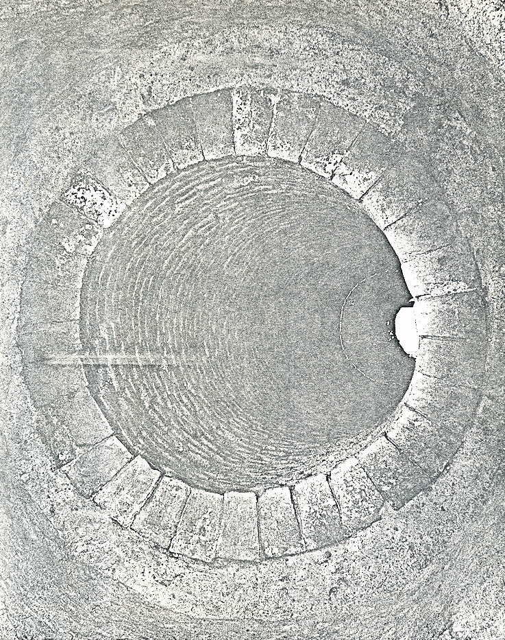 Plate LV. — Well shaft in the "Boxwood Garden" after being excavated to a depth of 32'6" below modern grade; photographed from the north. 71-FD-1180.
101.
to dark red in color and had average measurements of 7-5/8 inches by (5-¼ inches by 3-5/8 inches) by 2-3/8".2
Plate LV. — Well shaft in the "Boxwood Garden" after being excavated to a depth of 32'6" below modern grade; photographed from the north. 71-FD-1180.
101.
to dark red in color and had average measurements of 7-5/8 inches by (5-¼ inches by 3-5/8 inches) by 2-3/8".2
The filling was perhaps the least impressive aspect of this particular feature. The upper strata (3 inches to 6 feet 2 inches below modern grade) consisted of black loam with occasional oystershells, brickbats, cement fragments, and pockets of coal ash. The artifacts (C.G.1620 A & B) were deposited sometime during the twentieth century — probably around 1930 when Mrs. McRae effected many changes to the property. The majority of the well (6 feet 2 inches to 32 feet 6 inches below modern grade) had been filled with a mixture of sand and small shell fragments which presumably had been procured from the river shore. This deposit (C.G.1620 C & D) only produced a minimal number of artifactual finds and these were also modern in date.
The digging continued to a depth of 32' 6" (B.M.G.) before the project was abandoned. Since water was coming into the shaft at a rapid rate, the progress was slowed considerably and this factor, coupled with the late filling date, combined to make it uneconomical to proceed further. One additional note should be made concerning the lining because, since it survived in such excellent condition, tentative plans were formulated to have the well returned to its original appearance and function. With this in mind, the decision was made to merely cap the shaft with a sheet of 102. steel (3/8" thick) and then add at least five feet of soil3 to level the area to the existing grade.
Unfortunately, no definite date could be ascertained for the well's construction. However, the yard metaling and brick paving which surrounded the shaft (See Plates LVI & LVII) had been put there in the last quarter of the eighteenth-century. Assuming that it represented an attempt to solidify the area around the well, one could conjecture that the well itself was built in the period c.1775 - 1800. A description of these yard levels, along with the dating evidence, is discussed below.
Much of the "boxwood garden" had been disturbed down to the natural subsoil during the nineteenth and twentieth centuries but, presumably since the well had apparently been standing until rather recently, that general area escaped most of the grading. A small section of brick paving survived east of the well and there were occasional flat (apparently laid) bricks to the north and west of it (See Figure 29 & Plate LVII). A stratum of brick rubble and oystershells (C.G.141G) was found to overlay a portion of the paving but the majority was on the same level as the brickwork (See Figure 30). This lead to the question of whether or not the deposit post-dated the paving or had served as contemporaneous yard metal ling. A case could be made for
FIGURE 29 [oversized image]
FIGURE 30 [oversized image]
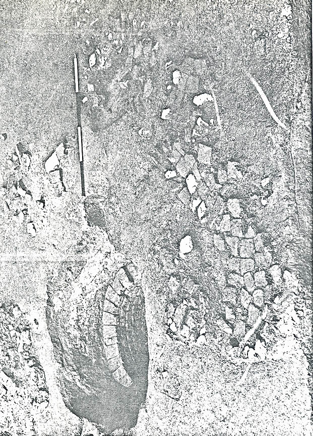 Plate LVI. — Yard levels surrounding the well in the "Boxwood Garden"; photographed from the east. 72-INH-257
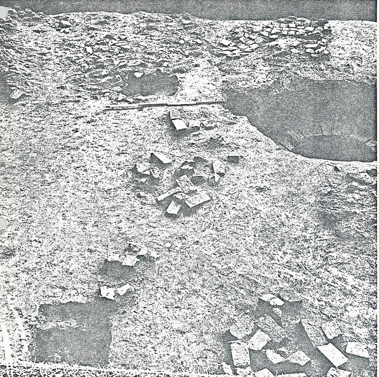 Plate LVII. — Flat bricks (apparently laid as paving north and west of the well (center and right foreground). Yard metal ling and paving made from brick bats is in background; photographed from the west. 72-INH-258
103.
either alternative and, needless to say, the archaeological study was not successful in proving irrefutably which was correct. However, since the rubble layer only covered the bricks that had apparently settled more than the others (those on the northern end were some 1 ½" to 2" lower), one would be safe in saying that it is entirely possible that the paving and the metal ling were in existence at the same time.
Plate LVII. — Flat bricks (apparently laid as paving north and west of the well (center and right foreground). Yard metal ling and paving made from brick bats is in background; photographed from the west. 72-INH-258
103.
either alternative and, needless to say, the archaeological study was not successful in proving irrefutably which was correct. However, since the rubble layer only covered the bricks that had apparently settled more than the others (those on the northern end were some 1 ½" to 2" lower), one would be safe in saying that it is entirely possible that the paving and the metal ling were in existence at the same time.
At any rate, the most important deposit in this area was the one which definitely predated both the paving and the spread of brick rubble and oystershells. The earlier stratum (C.G.141H) consisted of loosely-packed dark brown clay with pebbles, along with artifacts dating as late as c.1780. Thus, one can assume that the "boxwood garden" area was more utilitarian than decorative by the last quarter of the eighteenth century. As stated on page 102, the well was conjectured to have been built at about the same time that the paving and yard metal ling was installed so, if these theories are valid, authenticity dictates that the total appearance of this area must be altered considerably when the well is reconstructed.
An abandoned drainage ditch, pursuing an approximate north/south course, was discovered some thirty-four feet east of the kitchen (see Figure 29). Unfortunately, the filling (C.G.140J, 144Q, 1621B, & 1622E) produced no artifacts; however, it was determined that this feature predated the metal ling deposits and was apparently cut through by the well shaft. The fact that a continuation of the ditch was discovered beneath and north of the dairy (?) outbuilding (see page 22 ), uncovered north of the boxwood 104. garden, indicates that it had not been installed to service that structure of the well.
The feature's sides sloped to a relatively flat bottom and the base had been pitched slightly to facilitate a southerly flow of water. The average width was 2'10" and the depth varied from 1'11" to 2'3" below modern grade. No attempt was made to locate where the ditch terminated but it was conjectured that the contents were deposited in the natural ravine located east of the terraced front yard.
The majority of eighteenth century artifacts, found in the "boxwood garden" section of the site, were concentrated within a fifteen foot radius of the well. Perhaps the most interesting and intriguing pottery sherd was unearthed east of the shaft in a deposit of mixed ashes (C.G.131C). It was a fragment of a brown stoneware bottle with the following embossed inscription:
G: BurwellThis was the first documentary artifact found on the Carter's Grove property that could be directly associated with a member of the Burwell family, but fragments of another similar seal were recovered later west of the "Boxwood Garden" (see page 110).
d
Edw: Attaws
1755
A preliminary research investigation indicated that Edward Athawes was one of London's principal merchants but, unfortunately, the study failed to find a single Burwell having the initial "G" until 1799. A possible explanation 105. for this perplexity is that the craftsman who cut the mold misread the instructions and formed a "G" instead of a "C". The fact that the name Athawes was incorrectly spelled seems to support the theory. Perhaps future studies will clarify this quandary.
With the kitchen at such close proximity to the "boxwood garden", it was not surprising to find that almost all of the colonial artifacts recovered from this area were domestic in nature. These finds of course, will be especially useful to those charged with replacing authentic wares in the mansion as well as the kitchen. Although no actual count was made, it was estimated that the quantity of eighteenth century material from this small section of the site matched that previously recovered from the remainder of the property.
The assemblage included portions of plates made from delftware, Chinese porcelain, white saltglaze, and creamware (one of the creamware plates had an unusual scalloped-edge pattern); bowls of delftware, creamware, white saltglaze, and Slipware; and saucers of marbled creamware and white saltglaze. There were fragments of tea bowls made from English and Chinese porcelain, marbled creamware, and white saltglaze; cups of delftware, Chinese porcelain, and white saltglaze; and tankards of white saltglaze, Rhenish stoneware, Brown stoneware, and coarseware; and pans made from Buckley, West of England, Slipware, and coarseware. In addition, the digging produced three pieces of a handpainted (overglazed) creamware teapot and a lid from another made of sprigged redware; a single sherd from a French coarseware pot with a green glaze; and many mendable pieces from a German 106. stoneware jug with a reindeer design considered rare to Williamsburg excavations. This represents only a partial listing of the artifacts recovered during the eight-week project.
Due to a change in scheduling on another project, excavations were resumed at Carter's Grove during the winter months of 1972. This phase of the work was confined to an area located north of the kitchen and immediately west of the "boxwood garden" (see Figure 29). Unfortunately, the digging did not provide an abundance of evidence to aid the reconstruction program nor did it contribute great quantities of colonial artifacts. Indeed, the most important discovery was made (quite by accident) in an area some thirteen feet north of our excavation limit.
The installation of a new water system to service the plantation coincided with most of the archaeological investigation so almost continuous monitoring was performed especially as the trenches neared the mansion and its dependencies. Even so, the machinery cut through the east wall of a rather substantial structure (see Figure 29) located only 7 feet west of the dairy(?) building investigated earlier. Careful digging subsequently uncovered the building's west wall as well as its southwest corner. Thus, it was possible to determine that the structure had an exterior east/west measurement of 20 feet 8 inches and further testing indicated that the north/south dimension was at least 24 feet. The footings were approximately 1 foot 6 inches wide and the bricks had been bonded with 107. oystershell mortar. Future work is planned for this area in order to define the exact size and utilization of the building. It should be noted that an extant plat (1874) shows a structure in this general area (see Appendix IV) so one could conjecture that the building in question survived at least until 1874 but obviously additional digging is called for to prove or refute this theory.
Perhaps the largest quantity of colonial artifacts was found in a shallow east/west drain located only eight inches north of the kitchen (see Figure 29). The filling (C.G. 386L and 1619E) consisted of gray clay with brick fragments and datable material deposited sometime after c.1775. The more impressive finds included mendable pieces from plates and bowls of Chinese porcelain and also a saucer and teabowl of the same ware except that the latter had been overglazed. There were fragments of brown stoneware jars, a German stoneware tankard, a coarseware bowl, many pieces of beverage bottles along with a fragment of an engraved wine glass. The metallic finds included a brass thimble, at least three brass pins, an iron curry comb, and several pieces from an iron kettle.
The drain had apparently been constructed to carry the water in an easterly direction (although all of the elevations were not consistently lower in that direction) and, since both ends had been cut through by modern disturbances, it was not possible to determine where the contents had been deposited. There was no evidence to indicate that the trough had ever been lined.
FIGURE 31 [oversized image]
At least three different levels of brick paving (see Figure 31) were encountered north of the drain — one was modern and was still in use but even the earliest dated from the nineteenth century. A stratum of black loam with oystershells (C.G.386F) passed beneath the lower path and the artifacts from the deposit provided a terminus post quem of post c.1850 for the walkway's existence. Consequently, this evidence should not be considered a factor in the area's reconstruction planning.
Only two strata beneath the above mentioned loam layer were considered to be of eighteenth century date and these were thought to represent construction debris from the mansion and/or its dependencies. A widely spread layer of brick rubble (C.G.386J) was found extending up to 20 feet from the east wall of the mansion and more than 8 feet north of the kitchen (see Figure 29). The stratum was uniformly dispersed and had been scattered atop the natural subsoil. As already noted, it was theorized that the rubble had accumulated during a construction project. Adding some strength to this conjecture was the discovery of a rather thick but localized deposit of oystershell mortar (C.G.386K) which was partially sealed by the rubble layer. The fact that the mortar's surface was very uneven seems to indicate that it had been dumped while wet perhaps at the end of a work day. Another possible explanation is that this mortar represents the spillage from a mixing operation but in either case the evidence would appear to appoint to a deposition during building or repair activity.
109.Another spread of brick rubble was encountered some thirty-seven feet north of the kitchen but it did not seem to be associated with that which was described on page 108. It should be recalled that the latter had been deposited directly on the natural subsoil but the former was found to be sealing a considerable amount of stratigraphy (see Figure 31). In addition, some of these bats appeared to have been laid (see Plate LVIII) so it seems conceivable that paving had been installed in this area and, as will be explained below, it could have been in existence during the eighteenth century.
Directly beneath the brick remains was a layer of mottled yellow clay (C.G.1628C) which produced only a minimal number of artifactual finds but the latest dated from the second quarter of the eighteenth century (see Figure 32). This period thus becomes the terminus post quem
of the deposition of the brick fragments. This clay layer sealed a very thin stratum of scorched brown clay (C.G.1628D) which in turn covered an equally thin deposit of burned oystershell mortar (C.G.1628E). There was no evidence of wood ash or the remains of any other combustible material and no clues were found to help establish a specific purpose for the fire (s). Perhaps this merely represents an effort on someones part to either keep warm or have a hot meal. At any rate, these burned layers sealed a stratum of dark brown clay (C.G.1627D, 1628F, 1629F) which had accumulated during the first half of the eighteenth century. The artifacts from the deposit included fragments from a French green-glazed coarseware pot, a coarseware pan, a brown stoneware tankard, beverage bottles,
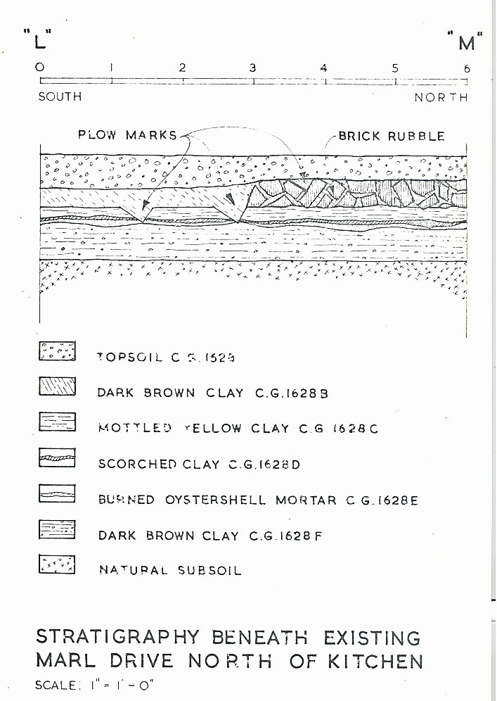 FIGURE 32 — STRATIGRAPHY BENEATH EXISTING MARL DRIVE NORTH OF KITCHEN
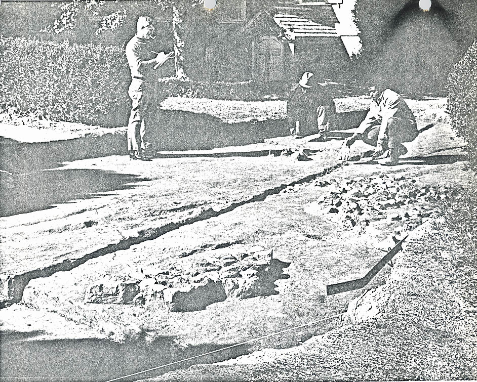 Plate LVIII. — Brick rubble uncovered north of the kitchen (right center) with what would appear to be laid brick bat (foreground). Photographed from the northeast. 72-FD-294
110.
window panes, a small two-piece door knob made of brass, and an iron nail.
Plate LVIII. — Brick rubble uncovered north of the kitchen (right center) with what would appear to be laid brick bat (foreground). Photographed from the northeast. 72-FD-294
110.
window panes, a small two-piece door knob made of brass, and an iron nail.
The digging produced evidence of a fence, oriented on a more or less north/south line, which apparently originated near the kitchen's northwest corner and stretched northward at least forty-three feet. A total of four postholes (see Figure 29) along this line were excavated but, unfortunately, none of the features contained artifacts nor was it possible to determine a date from the sealing strata. This last was due to the fact that three of the holes were in the previously graded area now covered by the modern drive and the fourth was all but destroyed by modern planting disturbance. Thus, all that can be said is that at some point in the site's history a fence was installed in this location.
East/west plow marks discovered less than 32 feet north of the kitchen (see Figure 29) points up an interesting factor concerning the plantation's utilization through the years. A continuation of these features in a westward direction would indicate agricultural activity within 23 feet of the mansion. This of course has no bearing on the colonial appearance of the area but it does help show how different the land must have looked in the nineteenth and twentieth centuries.
Undoubtedly, the most important artifactual finds from this phase of the project were fragments of a sealed brown stoneware bottle. These were recovered from a stratum of dark brown clay (C.G.1627B) in the area immediately west of the "boxwood garden". Although several key pieces were 111. missing, the ornately embossed message seemed to be quite similar to that found on the stoneware sherd discussed on page 104. Both seals had the year "1755" on them but in this case it was of no consequence in dating the layer because a 1906 penny was found beside the fragments.
APPENDIX VI
| C.G. Number | Description |
|---|---|
| 131C | Mixed ash deposit with charred wood beneath the loam layer 131B and over lying the natural subsoil; post 1755. |
| 140J | North/south drainage ditch filled with light brown clay and apparently pre-dating the well. The metaling levels definitely post-dated this feature; no datable artifacts. |
| 141 | Topsoil in area 0-2-R-12; modern. |
| 141A | Light brown loam with brick and shell fragments beneath the topsoil and over lying a deposit of brick rubble; post c.1820. |
| 141G | Deposit of brick rubble and oystershells beneath the loam layer 141A and overlying the brick paving and a layer of brown clay with pebbles; post c.1780-1800. |
| 141H | Loose dark brown clay with pebbles, brick fragments, and oystershells beneath the above brick rubble deposit and overlying a stratum of mixed ashes. This layer pre-dated the brick paving; post c.1780-1800. |
| 141J | Mixed ash deposit beneath the above clay layer and resting on the natural subsoil, post c.1775. |
| 144Q | North/south drainage ditch filled with light brown clay and sealed by the clay layer 144L; no datable artifacts. |
| 386B | Dark brown loam with brick fragments on the same level as the 19th century paving and overlying the oystershell and loam deposit C.G.386F; no finds. |
| 113. | |
| 386F | Black loam with oystershells which pre-dated the lower paving north of the kitchen; post c.1850. |
| 386J | Brick rubble spread presumably representing construction debris sealed by the above loam deposit; no finds. |
| 386K | Thick but localized deposit of oyster shell mortar partially beneath the above rubble layer; no finds. |
| 386L | East/west drainage trough, located just north of the kitchen, filled with gray clay and small brick fragments; post c.1775. |
| 386M | Southeast portion of a posthole filled with light brown clay and partially destroyed by modern planting disturbance; no finds. |
| 1619E | East/west drainage trough, located just north of the kitchen, filled with gray clay and small brick fragments (same as C.G.386L); post c.1775. |
| 1620A | Upper filling in the well consisting of black loam with brickbats and modern mortar (3" to 3'5" below modern grade); modern. |
| 1620B | Black loam with oystershells, brickbats and coal ash beneath the loam deposit 1620A and overlying a stratum of sand mixed with marl (3'5" to 6'2" below modern grade); modern. |
| 1620C | Sand with marl and occasional brick fragments beneath the above loam deposit (6'2" to 23'9" below modern grade); modern. |
| 1620D | Wet sand with marl and occasional brick fragments as above except that this layer was below the water level (23'9" to 32'6" below modern grade); modern. |
| 114. | |
| 1621B | North/south drainage ditch filled with light brown clay and sealed by the loam deposit 1621A; no datable artifacts. |
| 1622E | North/south drainage ditch filled with light brown clay and sealed by the loam deposit 1622A; no finds. |
| 1627B | Dark brown clay beneath the topsoil and abutting the remains of brick paving; post 1906. |
| 1627D | Dark brown clay stratum beneath a layer of mottled yellow clay and overlying the natural subsoil; second quarter of the 18th century. |
| 1628 | Topsoil consisting of marl and gravel with a cinder base located near the eastern end of the major east/west drive north of the mansion; modern. |
| 1628B | Dark brown clay beneath the topsoil and abutting the remains of brick paving; post 1906. |
| 1628C | Mottled yellow clay directly beneath the brick paving remains and overlying strata of scorched clay and burned mortar; second quarter of the 18th century. |
| 1628D | Thin layer of scorched clay beneath the above clay deposit and overlying a stratum of burned oystershell mortar; no finds. |
| 1628E | Thin layer of burned oystershell mortar beneath the above deposit of scorched clay and overlying dark brown clay; no finds. |
| 1628F | Dark brown clay layer beneath the above mortar spread and overlying the natural subsoil; first half of the 18th century. |
| 1629F | Dark brown clay layer beneath the burned mortar and overlying the natural subsoil (same as above and C.G.1627D); second quarter of the 18th century. |
APPENDIX VII
Dating of Groups From Area's North and East of the Kitchen
Abbreviations Used:
- C - Century
- NF - No Finds
- NDA - No Datable Artifacts
| CG No. | Artifact Date | Archaeological Date |
|---|---|---|
| 131 | Modern | - |
| 131A | Post 1820 | - |
| 131B | Ca. 1785 with intrusions | - |
| 131C | Post 1755 | - |
| 131D | Post 1762 with 19th c. intrusions | - |
| 131E | Ca. 1785 | - |
| 132 | Modern | - |
| 132A | Post 1820 | - |
| 132B | Not excavated | - |
| 132C | Colonial | - |
| 133 | Modern | - |
| 133A | Mid 19th C. | - |
| 135 | Modern | - |
| 135A | Post 1880 | - |
| 135B | Mid 18th c. with 19th c. intrusion | - |
| 136 | Modern | - |
| 136A | NDA | - |
| 136B | Not excavated | - |
| 136C | Post 1835 | - |
| 137 | Modern | - |
| 137A | Post 1851 | - |
| 139 | Modern | - |
| 139A | NF | - |
| 139B | NF | - |
| 139C | NF | - |
| 139D | NF | - |
| 139E | Post 1762 | - |
| 140 | Modern | - |
| 140A | NF | - |
| 140B | NF | - |
| 140C | Post 1830 | - |
| 140D | Post 1755 | - |
| 140E | NDA | - |
| 140F | Post 1762 | - |
| 140G | NDA | - |
| 140H | NDA | - |
| 140J | NDA | - |
| 141 | Modern | - |
| 141A | Post 1820 | - |
| 141B | Post 1850 | - |
| 141C | - | |
| 141D | Ca. mid 19th c. | - |
| 141E | See 1620A | - |
| 141F | Post 1780 | - |
| 141G | Ca. 1780-1800 | - |
| 141H | Ca. 1780-1800 | - |
| 141J | Post 1775 | - |
| 141K | Post 1820 | - |
| 116. | ||
| 143 | Modern | - |
| 143A | NF | - |
| 143B | Post 1820 | - |
| 143C | NF | - |
| 143D | NP | - |
| 143E | First half 18th c. | - |
| 144 | Modern | - |
| 144A | Post 1820 | - |
| 144B | NF | - |
| 144C | NP | - |
| 144D | NF | - |
| 144E | Ca. 1850 | - |
| 144F | Post 1820 | - |
| 144G | NF | - |
| 144H | Ca. 1820 | - |
| 144J | Ca. 1820's | - |
| 144K | Post 1830 | - |
| 144L | Mid 18th c. | - |
| 144M | NF | - |
| 144N | NDA | - |
| 144P | Colonial | - |
| 144Q | NDA | - |
| 145 | Modern | - |
| 145A | NF | - |
| 145B | NF | - |
| 145C | NF | - |
| 145D | Ca. 1800 | - |
| 145E | Ca. mid 18th c. | - |
| 163 | Modern | - |
| 163A | Post 1850 | - |
| 164 | Modern | - |
| 164A | Ca. mid 19th c. | - |
| 164B | NF | - |
| 164C | 19th C. | - |
| 165 | Modern | - |
| 165A | Ca. mid 19th C. | - |
| 166 | Topsoil | - |
| 166A | Post 1858 | - |
| 167 | Modern | - |
| 167A | Post 1903 | - |
| 167B | Not excavated | - |
| 167C | Ca. 1857-1866 | - |
| 168 | Modern | - |
| 169 | Modern | - |
| 169A | Post 1868 | - |
| 170 | Modern | - |
| 170A | Post 1899 | - |
| 322 | Modern | - |
| 322A | NF | - |
| 322B | Second quarter 18th C. | - |
| 322C | Post 1850 | - |
| 322D | Second quarter 18th C. | - |
| 322E | Ca. 1780 | - |
| 117. | ||
| 324 | Modern | - |
| 324A | Post 1820 | - |
| 324B | Ca. 1740-60 | - |
| 386 | Modern | - |
| 386A | NF | - |
| 386B | NF | - |
| 386C | NF | - |
| 386D | NF | - |
| 386E | NF | - |
| 386F | Ca. mid-Cl9 | - |
| 386G | Post 1820 | - |
| 386H | NF | - |
| 386J | NF | - |
| 386K | NF | - |
| 386L | Post 1775 | - |
| 386M | NP | - |
| 1592 | Modern, NF | - |
| 1592A | Post 1867 | - |
| 1592B | NF | - |
| 1592C | NF | - |
| 1592D | NF | - |
| 1592E | Modern | - |
| 1592F | NF | - |
| 1592G | NF | - |
| 1592H | NF | - |
| 1592J1 | NF | - |
| 1592K | NF | - |
| 1592M | NF | - |
| 1592N | Ca. 1780 | - |
| 1592P | Post 1762 | - |
| 1592Q | Ca. 1800 | - |
| 1597 | Modern | - |
| 1597A | Modern | - |
| 1604 | Modern | - |
| 1604A | Post 1830 | - |
| 1604B | Post 1830 | - |
| 1615 | Modern | - |
| 1615A | Post 1850 | - |
| 1616 | Modern | - |
| 1617 | Modern | - |
| 1617A | Not excavated | - |
| 1617B | Post 1835 | - |
| 1618 | Modern | - |
| 1619 | Modern | - |
| 1619A | Post 1830 | - |
| 1619B | Post 1850 | - |
| 1619C | Ca. mid 18th c. | - |
| 1619D | Post 1730 | - |
| 1619E | Ca. 1775 | - |
| 118. | ||
| 1620A | Modern | - |
| 1620B | Modern | - |
| 1620C | Modern | - |
| 1620D | Modern | - |
| 1620E | Sample bricks | - |
| 1621 | Modern | - |
| 1621A | Ca.1850 | - |
| 1621B | NDA | - |
| 1622 | Modern | - |
| 1622A | Post 1853 | - |
| 1622B | Post 1835 | - |
| 1622C | NF | - |
| 1622D | NF | - |
| 1622E | NDA | - |
| 1623 | Modern | - |
| 1623A | Post 1835 | - |
| 1624 | Modern | - |
| 1625 | Modern | - |
| 1626 | Modern | - |
| 1626A | Mid 18th c. | - |
| 1627 | Modern | - |
| 1627A | NF | - |
| 1627B | Post 1906 | - |
| 1627C | - | |
| 1627D | second quarter of 18c. | |
| 1628 | Modern | - |
| 1628A | NF | - |
| 1628B | Post 1820 | Post 1906 |
| 1628C | Second quarter C18 | - |
| 1628D | NF | - |
| 1628E | NF | - |
| 1628F | C17 | First half of 18c. |
| 1629 | Modern | - |
| 1629A | NF | - |
| 1629B | Ca. mid-C19 | - |
| 1629C | Post 1780 | - |
| 1629D | NF | - |
| 1629E | NF | - |
| 1629F | Second quarter 18th c. | - |
| 1630 | Modern | - |
| 1630A | Post 1820 | - |
| 1630B | Post 1813 | - |
| 1630C | NF | - |
| 1630D | Ca. mid-19C | - |
| 1630E | NF | - |
| 1630F | NF | - |
| 1630G | NF | - |
| 1630H | Ca. mid-C18 | - |
APPENDIX VIII
A FAUNAL ANALYSIS OF WELL "A" AND WELL "B"
THE CARTER'S GROVE PLANTATION,
JAMES CITY COUNTY, VIRGINIA
John T. Penman
March 16, 1972
- Class:
- Amphibia
-
- Order:
- Salientia
-
- Family:
- Bufonidae
-
- Genus:
- Bufo
-
- Species:
- terrestris
-
- Common name:
- southern toad
- Family:
- Ranidae
-
- Genus:
- Rana
-
- Species:
- pippiens
-
- Common name:
- leopard frog
- Species:
- catesbeiana
-
- Common name:
- bull frog
- Class:
- Reptilia
-
- Order:
- Chelonia
-
- Family:
- Kinosternidae
-
- Genus:
- Kinosternon
-
- Species:
- cf. subrubrum
-
- Common name:
- mud turtle
- Order:
- Serpentes
-
- Family:
- Colubridae
-
- Genus:
- cf. Thamnophis
-
- Common name:
- ribbon snake
- Class:
- Aves
-
- Order:
- Galliformes
-
- Family:
- Phasianidae
-
- Genus:
- Colinus
-
- Species:
- virginianus
-
- Common name:
- bobwhite
- Class:
- Mammalia
-
- Order:
- Insectivora
-
- Family:
- Talipidae
-
- Genus:
- Scalopus
-
- Species:
- aguaticus
-
- Common name:
- eastern mole
- Order:
- Lagomorpha
-
- Family:
- Leporidae
-
- Genus:
- Sylvilagus
-
- Species:
- floridanus
-
- Common name:
- cottontail rabbit
- 121.
- Order:
- Rodentia
-
- Family:
- Cricetidae
-
- Genus:
- Peromyscus
-
- Common name:
- mouse
- Order:
- Cetacea
-
- Suborder:
- Mysticeti
-
- Common name:
- baleen whale
- Order:
- Carnivora
-
- Family:
- Felidae
-
- Genus:
- Felis
-
- Species:
- domesticus
-
- Common name:
- domestic cat
- Order:
- Artiodactyla
-
- Family:
- Suidae
-
- Genus:
- Sus
-
- Species:
- scrofa
-
- Common name:
- feral swine
- Family:
- Bovidae
-
- Genus:
- Bos
-
- Species:
- taurus
-
- Common name:
- cow
- Genus:
- Ovis
-
- Species:
- aries
-
- Common name:
- domestic sheep
Faunal List
Sources:
Martof (1956),
Stupka (1963),
Miller and Kellogg (1955).
Faunal Analysis of the Carter's Grove Wells A and B
James City County, Virginia
The Carter's Grove Plantation is located on the eastern bank of the James River, and about six miles southeast of Williamsburg, Virginia.
Robert Carter, for whom the site is named, purchased the tract of land presently called Carter's Grove in the early 1720's for his daughter and son-in-law. In 1737 Robert Carter's grandson inherited the plantation and lived there until his death in 1756. The estate then passed to Nathaniel Burwell who lived on the estate. The property passed through several hands and the mansion is still occupied.1
Excavations were carried out at Carter's Grove from June, 1970 to September, 1971. During this time, a brickyard containing two wells was found between the mansion and the river.2
Analysis of the artifacts from these wells indicates a range of time of 1740-1760 for Well A (CG 1315) and 1740-1755 for Well B (CG 1111). It is presumed that these wells were used for drawing water to be used in the brickmaking operation, and were not used for drinking water. This explains why the wells were not lined above ground to protect the water from contamination.
123.One important find on the plantation, in a nearby refuse pit was several goose eggs. There were however, no remains of domestic geese in either of the wells.
Of the identifiable animal bones from the wells, thirteen genera were positively identified, and one probable whale was found. The whale, represented by a single vertebra, probably represents an intrusion into Miocene deposits by the eighteenth century well diggers.3 The thirteen genera which were positively identified were all probably contemporaneous to the 1740's through 1760's. A study of these animals' life styles might indicate how they came to be deposited in the wells.
Bufo terrestris lives in wooded areas with good rainfall. Also known as the Southern Toad or American Toad, this animal lives under logs, stones, etc. and hibernates in underground burrows.4
Rana catesbeiana , the bullfrog, and Rana pippiens , the leopard frog, prefer ponds, lakes, and meadows. Rana pippiens breeds in marshy surroundings. The subspecies R. p. spenocephala (Southern Leopard frog) is common in the coastal plains area of Virginia today.5
Two species of the genus Tramnophis inhabit the Tidewater Virginia area. T. sirtalis , the ribbon snake, requirs a moist habitat, while T. ordinatus , the garter snake, is not confined 124. to a wet environment. They are both diurnal, and feed on frogs, salamanders, fish and the like. Both could be found in the microenvironment of Carter's Grove.6
The only birds present in the material from the wells are bobwhites. The bobwhite inhabits sparsely wooded areas, but prefers open fields. They nest on the ground, and they travel in conveys.7
The moles found at Carter's Grove are Scalopus aguaticus . They are burrowing animals, and they prefer cultivated fields and old fields, but may be found in all types of soil.8
Sylvilagus floridanus , the cotton tail, represents the great majority of animals identified from Well B. Four specimens were found to have characteristics similar to S. palustis, the marsh rabbit. However, these cranial differences might also be due to individual variation, and thus have been identified as S. floridanus . The cottontail lives in wooded and open areas, but old fields and croplands are optimum environmental conditions.9
Peromyscus the deer mouse, is represented by one individual. There are presently two species in Virginia; P. lencopus (white-footed mouse) and P. gossypinus (cotton mouse). Both live in brushy areas in the lowlands, nest on the ground, and are nocturnal.10
125.The whale remains from Well A were a vertebra and right mandibe ramus. The mandibe fragment was identified as being in the suborder Mysticeti and possibly of the genus Parietobalaena . The vertebra was identified as being Cetacean. The vertebra, mandible fragment and two other fragments are fossilized. Frank C. Whitmore, Jr. identified the Mysticeti, while the vertebra was identified by Florida State University. It is suggested here that both are probably of the same suborder if not the same individual. The fossilization of these bones, and the nature of the specimens indicates that the well's lowest level pierced a fossil layer, presumably the Yorktown Formation.11
Domestic animals account for about 16% of the total number of individuals found in the wells. Of these animals, the sheep, cows, and pigs were recorded as being in Jamestown as early as 1616.12 While the cats have not been mentioned, it is supposed that by 1740 a plantation owner would have been maintaining a few cats in the kitchen.
All of the above mentioned animals would have found the Carter's Grove plantation a suitable surrounding. Therefore, given the habitats of these animals, and the amount of bone identified (for example, 1609 pieces represents 44 individuals for Sylvilagus in Well B) and the nature of the material (that is, toe bones were also found and no signs of butchering present), the conclusion is that, except for the pigs, all remains represented in both wells is due to accidental drownings.
126.The material from Well A is in various states of preservation; this could account for low numbers of pieces per individual. Some material was well preserved, while the majority was not. A comment should be made as to the nature of the cow tibia in 1315K. This bone is much smaller than the holstein specimen used in comparison, yet it is older. This indicates that the eighteenth century breed was smaller. Also, due to the obvious mixing of levels in Well A, close scrutiny was needed in determining numbers of individuals. Since the non-Holocene material was found in the upper level, it can be assumed that the cow remains in Well A were also subject to this mixing. Therefore it has been established that only one individual of Bos is present in Well A.13
The remains from Well B are in the best state of preservation and represent a great variety of animals. In Well B 94.84% of the bone material was identified, indicating the remarkable conditions of preservation.
The variation in percentages of animals from level, particularly Sylvilagus and R. pippiens , may indicate seasonality of deposition, but this can not be certain.
No indications of mixing of levels was found in Well B, thus the members of individuals and percentages are believed to be accurate (Chart 2).
As previously stated the pig remains were not a result of accidental drownings. These remains are all metapodials, phalanx, centeral podials, and calcaneal bones. This leads to the conclusion 127. that at some time a brickyard worker (or workers) may have had pig's feet for lunch.
Some amount of age determination can be done using foot bones of Sus as indicators. Two calcaneal, representing one individual, were recovered from 1111 J. These bones were fused, indicating that the animal was about 2.5 years when killed.14 The remainder of the animals were about age two years or less, since metapodials were not fused distally. Seven of these "younger" animals were considerably smaller in comparison to the other six, and could possibly have been infants at the time of death.
The sheep in level 1111J of Well B represents an individual younger than 1.5 years, due to the fact that the humeri have not fused distally.15
The two cats were immature at the time of death, as evidenced by the size of the bone material.
In conclusion, only about 9% of the total remains from Well B were in fact refuse remains, while a minimum of 110 individuals drowned. Assuming that the wells were not dug for domestic purposes, most animal specimens represented must be presumed to be results of drownings rather than refuse from the kitchen. Although no conclusions can be drawn as to the range of meat eaten at Carter's Grove or as to butchering techniques employed there, several points can be made with certainty: Domestic cattle were considerably smaller than breeds today, and sheep, pigs, and house cats were maintained on plantations in the Williamsburg area by 1750. It must be admitted, however, that none of these conclusions are new, for there is ample historical and archaeological evidence to support identical deductions at much earlier dates.
chart 1
WELL "A"
CG ER 1315
| Provenience | Description | Number of Individuals | Number of Pieces |
|---|---|---|---|
| 1315A | Fossilized fragment | 2 | |
| Unidentified | 1 | ||
| 1315B | Bos | 1 total | 8 |
| Suborder Mysticeti | 1 total | 1 | |
| Unidentified | 2 | ||
| 1315C | Bos | 1 | |
| Unidentified | 2 | ||
| 1315F | Order Cetacea | 3 | |
| Unidentified | 1 | ||
| 1315K | Bos tibia | 1 | |
| 1315M | Sylvilagus | 5 |
| Total Number of Pieces: | 27 | |
| Total Number Identified: | 19 | |
| Percent Identified: | 70.37 |
chart 2
Well B
CG ER 1111
| Genus | Total Number of Individuals | Percent of Individuals | Number of Pieces |
|---|---|---|---|
| Provenience 1111 H | |||
| R. pippiens | 1 | 5.88 | 2 |
| Kinosternon | 1 | 5.88 | 27 |
| Colinus | 2 | 11.76 | 3 |
| Sylvilagus | 10 | 58.82 | 257 |
| Sus | 1 (immature) | 5.88 | 4 |
| Bos | 1 | 5.88 | 1 |
| Ovis | 1 | 5.88 | 1 |
| Total | 17 | 99.88 | 295 |
| Provenience 1111 J | |||
| Bufo | 1 | 1.10 | 2 |
| R. pippiens | 34 | 37.36 | 206 |
| R. catesbeiana | 1 | 1.10 | 1.0 |
| Kinosternon | 3 | 3.30 | 95 |
| cf. Thamnophis | 1 | 1.10 | 1 |
| Colinus | 1 | 1.10 | 3 |
| Scalopus | 2 | 2.20 | 12 |
| Sylvilagus | 32 | 35.16 | 1308 |
| Peromvscus | 2 | 2.20 | 10 |
| Felis | 2 | 2.20 | 7 |
| Sus | 1(mature) | ||
| 4 (immature) | |||
| 6(infant) | 12.09 | 194 | |
| Ovis | 1 | 1.10 | 130 |
| Total | 91 | 100.01 | 1969 |
| Provenience 1111 K | |||
| Bufo | 4 | 25.00 | 4 |
| R. pippiens | 5 | 311.25 | 15 |
| R. catesbeiana | 1 | 6.25 | 1 |
| Sylvilagus | 2 | 12.50 | 44 |
| Permyscus | 1 | 6.25 | 1 |
| Sus | 1(immature) | ||
| 1(infant) | 12.50 | 17 | |
| Ovis | 1 | 6.25 | 5 |
| Total | 16 | 100.00 | 87 |
chart 3
Well "B"
| Genus | Total Number Individuals | Total Percent of Individuals | Total Pieces | Percent of Pieces |
|---|---|---|---|---|
| Bufo | 5 | 4.03 | 6 | .26 |
| R. pippiens | 40 | 32.26 | 223 | 9.49 |
| R. catesbeiana | 2 | 1.61 | 2 | .09 |
| Kinosternon | 4 | 3.23 | 122 | 5.19 |
| cf. Thamnophis | 1 | .81 | 1 | .04 |
| Colinus | 3 | 2.42 | 6 | .26 |
| Scalopus | 2 | 1.61 | 12 | .51 |
| Sylvilagus | 44 | 35.48 | 1609 | 68.44 |
| Peromyscus | 3 | 2.42 | 11 | .47 |
| Felius | 2 | 1.61 | 7 | .30 |
| Sus | 14 | 11.29 | 215 | 9.15 |
| Bos | 1 | .81 | 1 | .04 |
| Ovis | 3 | 2.42 | 136 | 5.78 |
| Total | 124 | 99.99 | 2351 | 100.02 |
| Total Bones for Well B: | 2479 |
| Total Bones Identified: | 2351 |
| Total Percent Identified: | 94.84 |
| Total Bones for Well A and Well B: | 2506 |
| Total Identified for Well A and Well B: | 2370 |
| Total Percent Identified for Both Wells: | 94.57 |
BIBLIOGRAPHY
- Cornwall,I. W.,, 1956
Bones for the Archaeologist, Phoenix House Ltd., London. - Golley, Frank B., 1966
South Carolina Mammals, Contributions from the Charleston Museum, No. 15, Charleston Museum, Charleston, South Carolina. - Hume, Ivor Noël, 1972
Personal Communication of February, Colonial Williamsburg Inc., Williamsburg, Virginia. - Kelso, William M., 1972
"Exploratory Excavations at Carter's Grove Plantation: An Experience in Rural Archaeology", Paper presented to the Society for Historic Archaeology, Fifth Annual Meeting, Tallahassee, Florida. - Martof, Bernard S., 1956
Amphibians and Reptiles of Georgia, University of Georgia Press, Athens. - Miller, Gerrit S., Jr., and Remington Kellogg, 1955
A List of North American Recent Mammals, United States National Museum, Bulletin 205, Government Printing Office, Washington, D.C. - Rolfe, John 1971
A True Relation: of the State of Virginia Lefte by Sir Thomas Dayle Knight in May Last 1616, Jamestown Documents, University of Virginia Press, Charlottesville. - Smith, Hobart M., 1950
Handbook of Amphibians and Reptiles of Kansas, Museum of Natural History, Publication No. 2, University of Kansas, Lawrence. - Stupka, Arthur, 1963
Notes on the Birds of Great Smoky Mountains National Park, University of Tennessee Press, Knoxville. - Whitmore, Frank C., Jr., 1972
Personal Communication of March l, United States Department of the Interior, Geological Survey, U.S. National Museum, Washington, D.C.