Capitol Notes Architectural Report Block 8 Building 11
Colonial Williamsburg Foundation Library Research Report Series - 1392
Colonial Williamsburg Foundation Library
Williamsburg, Virginia
1990
Capitol Notes
The following report was prepared by A. H. Hepburn of the firm of Perry, Shaw and Hepburn, Boston, Massachusetts, Architects for the reconstruction of the colonial Capitol at Williamsburg, Virginia.
These notes are a condensation of exhaustive research and are presented to explain briefly the factors which determined the design of the building as reconstructed in 1932-1933.
In determining the form of the building the following aids were of inestimable value: The archaeological evidence revealed by examination of the foundations, study of character of brickwork and the documentary evidence consisting of Hening's Statutes at Large, Journals of the House of Burgesses, The Capitol Report prepared by the Department of Research and Record of Colonial Williamsburg Inc. and particularly the Bodleian Plate which shows an accurate view of the north elevation of the original building.
S. P. Moorehead
S. P. Moorehead
Colonial Williamsburg
Architectural Department
January 23, 1947 .
CAPITOL NOTES BY A. H. HEPBURN
Collected October 21, 1946
"The State House in Jamestown was burned in 1698. In 1699, the government of the Colony of Virginia was moved to Middle Plantation thereafter called Williamsburg, and a new State House to be called 'The Capitoll' was ordered to be erected there."
The original Capitol has begun in 1701 and substantially completed in 1706. It burned in 1747. The second building was begun in 1751 and was abandoned to other uses when the state capitol was moved from Williamsburg to Richmond in 1779. A replica of the first building has been constructed in accordance with the evidence. A study of the second building is interesting and necessary for the evidence it gives as to the plans of the original building. It should be borne in mind that in preparing plans for the reconstruction all available evidence had to be considered and all apparent contradictions explained.
In considering the history of the building and its plan in relation to the early plan of the Town, we were faced with the curious fact that the facade of the building facing the Duke of Gloucester Street (which no one would expect would have been the principal front and main entrance of the building) was a secondary "front." A recognition of this fact made the subsequent changes in the west facade understandable. The following evidence is interesting and was presented to the A.P.V.A. as follows:
"York Records
Vol. II. Deeds and BondsMay 8, 1712
Revierre, Claude Chermoson, Elizabeth, widow
....All those two lots of land with dwelling house and 2 outhouses which was the testators at the time of his death, lying and being in the City of Williamsburg, on the back side of ye Capitol near ye Public Goal, designed in the plot of the said city by the figures 279, 280. . .
(Executors of Joseph Chermoson)
to
Cunningham, David, barber
Consideration 5 Shillings
* "You will note that the north side of the Capitol is referred to in 1712 as the back side of the Capitol near the public goal. It might not be unreasonable to consider the opposite side the main font. The lots 279 and 280 are lots on that side of the Capitol as you also know. Therefore, this north side which we have always contended was the official or architectural front of the building, had been neglected even as early as 1712, and some other approach to the building had become more important.
* "We know that there are a number of people who will immediately insist that the west front became the important entrance to the building at this time or previous to this. However, this is contrary to all the evidence we have been able to gather and also in our opinion, contrary to common sense. In the first place, to enter the building from the west would have necessitated a free passage to the public, through the General Court and there would have been no other possible way of approaching the other rooms in the Capitol Building, whereas an approach from the north or the south and particularly from the north, made it possible to approach any part of the Capitol without going through any other part of it except the arcade or the "piazza" between the two wings.
* "I do not wish to repeat all the past arguments on this point but it is obvious to us that the word 'front' is used without any more definite meaning than that in which we would use the word 'facade', and there were certainly four fronts or facades to this building and all were important architecturally.
* "You will note also that there is a reference dated October 1705 which reads as follows:Notes, p. 122.
'Middle of the front on each side of said building shall have a circular porch with an iron balcony upon the first floor over it.'
* "These evidently are the east and west fronts since we know there were circular porches here and we also know that there were none on the north and south fronts.
*"We now believe that the north side was given up as the main approach because of the lay of the land and the fact that the approach from the York Road would have been more direct to the south entrance.
* "The old engraving does not show the coat of arms on the north side of the cupola. Therefore, this coat of arms to have been painted on the cupola at all, must have been painted on the south side, since the cupola was hexagonal. For the same reason if the south side had become the important entrance to the building, the carved brick might reasonably have been placed on that side; the omission of it in the engraving which was made sometime after 1723, may not have been an oversight at all but may indicate that it was placed like the coat of arms, on the south."Presidents House, 1732
On November 5, 1720, closing of north arches authorized by Assembly.
3An examination of the old foundations (see plan, diagram B) showed the general plan of both the old and the new Capitols. There were, however, many alterations in and additions to the foundations which were not immediately obvious; for example, the chimney foundations in the north walls (ordered June 19, 1723) and a semicircular foundation on the west side which was not on the East and West axis of the first building, although almost on the axis of the Duke of Gloucester Street; the square form at south end of both wings was clearly a later change, and the square foundation projecting to the west which centered, not on the East and West axis of the first building, but on the overall length of the building (including circular ends) measured from north to south, was also a later addition and clearly contemporary with the square ends.
After meticulous examination of the brickwork we were able to differentiate the relative periods of construction (see indication on plan, diagram B). This was possible because of difference in mortar, size and type of brick, etc. at different times.
We had the invaluable journals of the House of Burgesses, Hening's Statutes, etc., without which it would have been impossible to solve the riddle of the plan with any assurance. The discovery of the Bodleian copper-plate (see Exhibit E) was a Godsend for it showed the north elevation of the original building very accurately (and with equal accuracy other important Williamsburg buildings).
It was possible from all these sources to arrange the evidence and to distinguish between foundations of the original building (1706-1747) with its minor changes, and the rather radical changes made when the second building was built in 1751.
The history of the Capitol Building from 1779 to 1927 is a sad one.
"In 1832, the Second Capitol burned, leaving only the walls standing. In 1839, by an act of the General Assembly, a Female Academy was incorporated 4 and later erected on the old site. Although this act was rescinded in 1849 (Sets of General Assembly - Dec. 4, 1848 - March 19, 1849, pp. 176-178) and a new name and different trustees were chosen, the lot continued to be called the 'old Female Academy lot' in 19th Century records. In the early part of the Civil War after the Battle of Williamsburg (1862) the building was used as a hospital for the wounded by a Union surgeon. (Letters of Union surgeons in William and Mary Quarterly, Second Series, Vol. 19, pp. 181-2; 184-6.) In the 80's the Female Academy lot with its building passed into the hands of the Old Dominion Land Company. (The Dominion Land Company was incorporated in 1880, and the deed transferring the lot was recorded in 1884. Records of Williamsburg and of James City County, Deed Book II, pp. 116-122.)"
The year 1881 was the year of the Centennial celebration at Yorktown, and the Chesapeake and Ohio Railroad was making a tremendous effort to connect their newly built road with their main line in time for the event. The planned right-of-way north of the town proved too troublesome to connect, so a temporary track was laid on the Duke of Gloucester Street, the remaining walls and foundations of the Female Academy were tumbled aside and a path for the "Iron Horse" was cleared over the foundations of the ancient Capitol.
Fortunately the A.P.V.A. acquired the property as a gift from the old Dominion Land Company in 1897. In 1904 the Association erected a monument with a bronze tablet - "To remind the passerby that great deeds are more enduring than brick and stone." They protected the foundations by a concrete cap, so that when excavation was undertaken in 1928 there was a considerable extent of foundation almost intact, and sufficient scattered relics of the remainder to give definite information as to the general plan.
After investigation of foundations, records, etc., the most important step was to establish the centers of openings in the facade of the original 5 building (since it had been agreed that the original building should be restored), the position of walls having been clearly established by excavation and study of foundation. The Bodleian copper-plate (see Exhibit D) showing the north elevation of the building as it was sometime after 1723 gave much information as to dormers, cupola, etc. We were justified in assuming that in east and west facades, both in the first and second buildings, the openings would have been symmetrically arranged (incidentally the arrangement of rooms, since we knew the general plan of the building, also imposed conditions as to the placing of openings).
The second building was built upon what was left of the original walls of the old building after the fire, but the apse ends were squared, changing the length of the west facade and with it necessarily shifting the center line of the facade. (See diagram A-IV). An examination of the rather crude drawings and paintings of the second building indicates that since the original openings on the first floor of the building were not wholly destroyed, they were used in rebuilding, changing them only from circular headed to square headed openings. It would be reasonable to use the standing walls rather than to take down and rebuild them from the ground up (see diagrams A-IV and E of second building) since they were only partially destroyed. " . . . . and the naked Brick Walls only left standing, which, however, seem good, except one or two small Cracks in the Semi-circles." (From Pennsylvania Gazette, February 5, 1747.) This being the case, the centers of new openings on the first floor were identical with the original centers, and would not only have been symmetrical in the facade of the first building, but in the facade of the second as well, with the addition of one Window added in each facade of the squared south ends. We found that to fulfill both of these conditions there was but one possible arrangement of the centers, viz:- (Diagram A) Call CL1 the center line of the original facade. Call CL2 the center line of the later facade. CL1 then is the center line of the doorway in the 6 original facade, and CL2 the center of the doorway in the new facade and almost the center line of foundation of semi-circular steps. CL2 must have been in the center of the space between two of the original openings if symmetry were to be maintained. Actually the true center of this facade was 4¾" to the north of the center line of foundation of semi-circular steps, and center line of circular foundation is 3½" to the south of the center line of the Duke of Gloucester Street. The latter dimension is based upon the most recent engineer's survey of the Duke of Gloucester Street (See Foundation excavation, Diagram B and Diagram A).
There had been, before we discovered a "formula", which definitely fixed the window spacing, a discussion with some of the members of the A.P.V.A.committee who believed that the old brick semi-circular foundation on west side proved that the great "folding gates" originally specified had been centered on it in the original building, and that this facade was the principal front. We believe that later the doorway was centered on this circular foundation, but since the foundation was of brickwork, whose age was uncertain, and since the original steps were specified to stand upon "cedar columns," if to be had, and since the original posts specified had disappeared, the existing foundation offered no positive proof as to location of original great doors which we felt sure must have been on the CL1. Further study of records indicated that there had been a number of changes in the original building before the fire destroyed it in 1747.
Some of the evidence of this is interesting: On August 28, 1701, "It is proposed that the cross gallery be the same width as the main building" (i.e. 30'). This proposal was not approved. Since the suggestion to increase the width of the cross gallery was later approved and so built, it is reasonable to suppose that the original plan showed a narrow gallery (of approximately 15'). See Diagram A-I). On October 2, 1701, the last day of that particular session, 7 the Governor signed a bill approving a change " . . . that the cross building betwixt the two main buildings be of the same breadth with the maine buildings." (Henings Statutes). We cannot explain the following reference, ". . . joyned by a Cross Gallery of thirty foot long and fifteen foot wide each way." An explanation of this clause might nullify our argument as to the mental processes of the Colonials but not as to the final plan of the building. We knew, however, that before completion of the building the plan as now built was approved; Henings Statutes, October 1701, III p. 213, (Diagram A-II), we had definite evidence of this in the Bodleian copper-plate (see Exhibit F) which shows the ridge of the cross gallery level with the ridge of the wings (therefore of the same width). This evidence clearly shows that this double gallery or "portico" existed at the time the drawing was made, i.e., after 1723, when chimneys shown were built in north ends of wings, since the engraving shows the building after the change above described was approved, it corroborates our conclusion that the original "gallery" was narrow. (See diagram A-I). It is obvious that when this doubling of width of gallery took place, the center line of the cupola which was built on the ridge or center of the cross gallery, would no longer be in line with the original "great doors" on CL1. It may be that the relationship between the axis of the west facade and the cupola which can now be seen in the replica of the original building, was not considered very satisfactory as the importance of the Duke of Gloucester Street was realized, and since there was space, (though crowded) between the center of the door CL1 and its adjoining window to the south, which would be on the axis of the cupola and almost on the axis of the Duke of Gloucester Street (substituting a window for the original door), the door was shifted and the semi-circular steps were built.
After the fire we know that this axis (CL2) was the center line of the 8 new facade because when rebuilding, as stated above, the apse ends were squared and a portico built centering upon this axis CL2 (see archaeological drawing, Diagram B, and Diagram E). As pointed out above, given the number of openings shown on all old drawings, this arrangement would have been possible only if the original openings were used in rebuilding and if the openings were placed as shown on plans. (See Diagram A-IV).
With centers of openings determined and much detailed information available as to plan, general appearance, ceiling heights, panelling, painting and furnishings, it was possible to reconstruct what we believe is a replica of the original Capitol.
Footnotes
APPENDIX
See "Archaeological Survey of the Capitol in Williamsburg", and Diagram "G".
| (a) C-D = 70' - 6" = A + A2+ (4 x B) | (Archaeological drawings give these dimensions) | |
| (b) C-E - 83' - 3 ½ " = A + A1 + (5 x B) | ||
| A= A1 =A2 | ||
| ?(a) 70' - 6" = 2A + 4B | 2A = (70' - 6") - 4B | |
| (b) 83' - 3 ½ " - 2A +5B | 2A = (83' - 3 ½ ") - 5B | |
| (70' - 6") - 4B = (83' - 3 ½ ") - 5B | ||
| B = (83' - 3 ½ ") - (70' - 6") = 12' - 9 ½ " |
In Diagram A-II and IV, C represents the northerly corner of the east facade and the line E, the southerly corner of the east facade with the apse squared out (that is, the plan of the later building). Dimension A would equal A1 for the reason that the windows were arranged symmetrically with relation to the corners of the building. The line D represents the southerly corner of the east facade before the apse was squared (the original building). It is fair to assume that the dimension A2 equals A1 equals A, because the arrangement in the original facade was without doubt symmetrical in its flat surface. Distance B therefore gives the spacing of the windows across the front of the building and it is obviously the only dimension which fulfills these conditions.
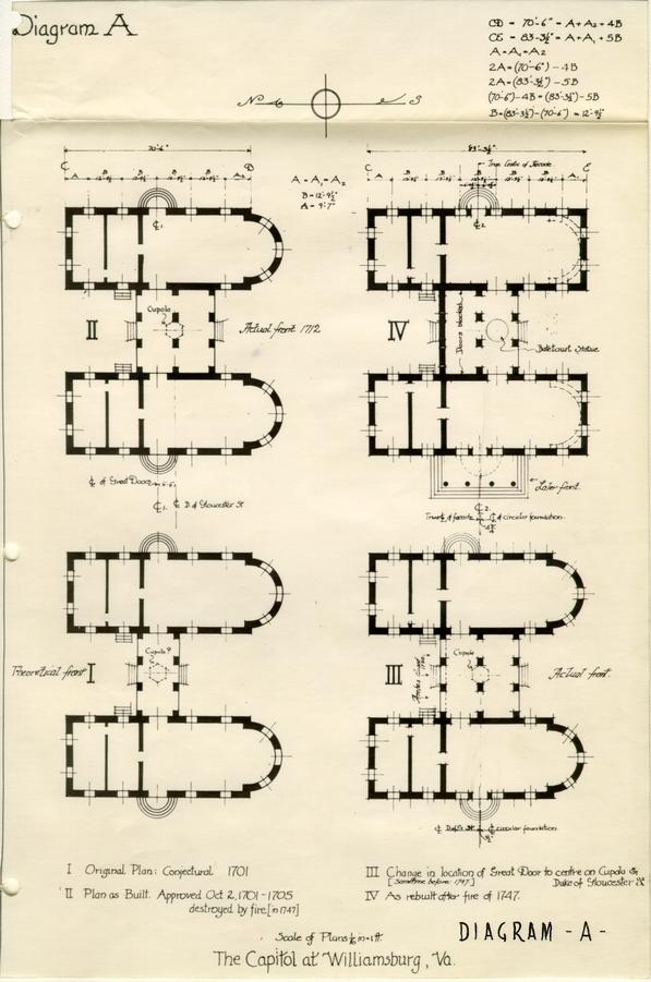 DIAGRAM -A-
 Diagram -B-
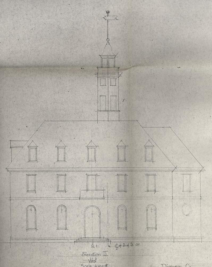
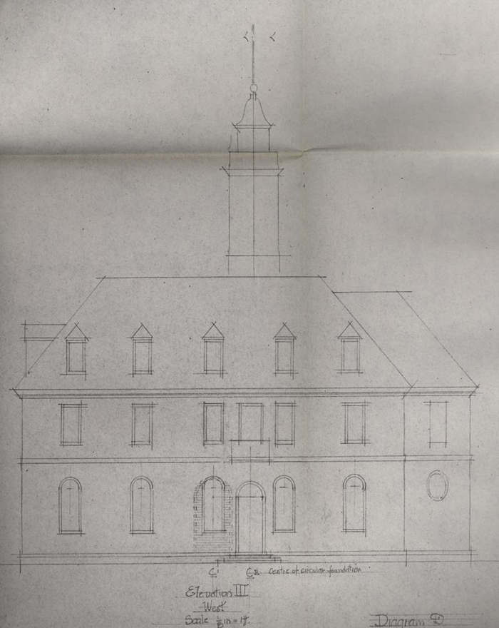 Exhibit D
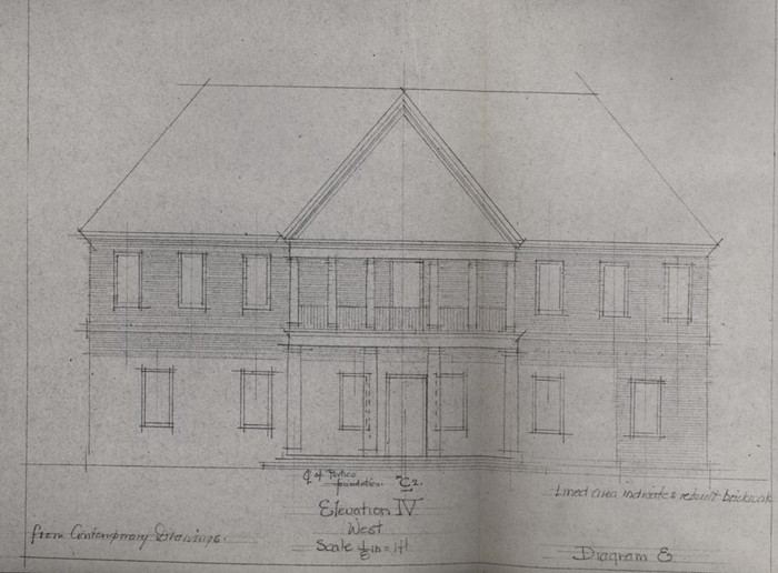 Diagram E
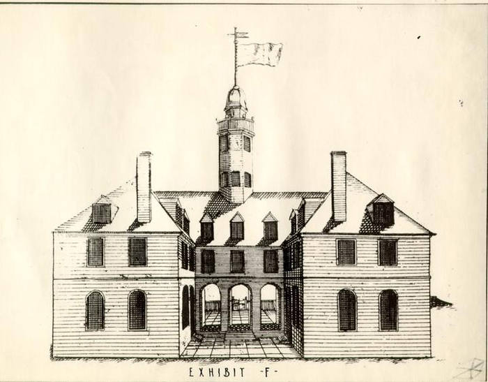
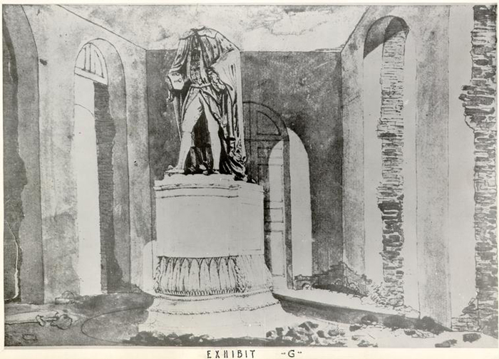 Exhibit-G-