Foundations of the Palace and OutbuildingArchaeological Excavations on Colonial Governor's Property
Colonial Williamsburg Foundation Library Research Report Series - 0013
Colonial Williamsburg Foundation Library
Williamsburg, Virginia
1990
ARCHEOLOGICAL EXCAVATIONS ON COLONIAL GOVERNOR'S PROPERTY
Foundations of the Palace and Outbuildings
Williamsburg, Virginia
NOTE: See separate reports about the Cemetery, found in the Palace Gardens, and the Examination and identification of the buttons, found in the graves.
-Foundations of the Palace and Outbuildings-
Williamsburg, Virginia.
| TO: | H. R. Shurtleff, Director, Department of Research & Record |
|---|---|
| Perry, Shaw, and Hepburn, Architects | |
| FROM: | Herbert S. Ragland, In Charge of Archeological Excavations. |
| SUBJECT: | Archeological Excavations on Colonial Governor's Property |
DATE: Feby. 25, 1932.
NOTE: (This report includes all information ascertained by excavation of the site to date, including that already submitted in partial reports made periodically as the work progressed.)
The foundations of the Governor's Palace, kitchen, office, stables and other outbuildings, the wells, brick paving, brick drains, remains of garden walls and walkways in the grounds, as well as a forgotten Revolutionary Cemetery in the middle of what once was the Palace garden, was found and uncovered by excavation during 1930 and 1931.
See Additions and Revisions in back of this book. HSR
Submitted herewith are archaeological drawings showing all the above mentioned remains and foundations. Submitted, also, are a map, showing the colonial layout, and a sketch showing the site where excavations were started.
THE EXCAVATIONS.
The excavations were begun June 30, 1930. Prentice Duell, archaeologist, supervised generally by the initial stages of the work and guided me in directing the digging until early Fall 1930. After that time I carried on the work in accordance with his archaeological methods. Todd 2 & Brown, Inc., Contractors, supplied the workmen.
The first exploratory trenches were staked out at the north end of the Palace Green, near the monument marking the site of the Palace, and on the north, east, and west sides of the old "Matty" School (since razed-see map.) The workmen commenced digging immediately. In all of the trial trenches (see sketch of the site), at a depth of about a foot, brick and plaster remains were found.
A clearly defined brick drain (see drawings- drain No. 8) was found before the first day's work was done. However, several days passed before the drain was identified. The next day, July 1st, about three feet below the surface of the ground, parts of three walls were uncovered. (See drawing- Walls Nos. 3, 4, & 12.)
Other large walls were found during the next few days, and on July 8th, a brick and stone paved floor, seven feet below grade, was discovered. It was evident that we were excavating in the basement of a large building that had been destroyed by fire, for many smoked bricks were found in the ruins. The debris, dug up, consisted mainly of brick, mortar, and plaster. There was a noticeably small percentage of earth mixed with it.
However, there were four large locust trees, growing in the debris. Some of the roots reached to the basement floor. The trees, which were two and more feet in diameter, were cut down. Their large stumps, with great difficulty, were removed from the site without damaging the foundation 3 Walls.
A runway from the basement floor to the top of the ground was built and the debris, as excavated, was wheeled to the north end of the grounds, out of the way of the work, where it was deposited for further examination.
The work progressed rapidly, and by the 10th of July a large area of basement floor, paved with stone flagging, in an unusually well preserved condition, was uncovered. The same day, a large chimney foundation, and several more thick walls were found. A few days later, scarcely any doubt remained that we were uncovering the Palace foundations, for the measurements between the walls then exposed agreed closely with the dimensions given by Jefferson on his first floor plan of the house. (The plan was used as a guide in directing the work.) Within another week all doubt was removed, for the front and rear foundation walls of the main portion of the Palace, and the east and west outside walls of the ball room portion were found and identified by the Jefferson plan.
The discovery of the front wall also disclosed that the north wall of the Matty School was built upon it. The outside (or north side) of the school was built flush with the inside (or north side) of the front (or south) foundation wall of the Palace. However, the school wall was not as wide as the Palace wall, so the line of demarcation between them was very definite. (See drawing). Arrangements for removing the school were made immediately, 4 and before the middle of August it was completely razed. As soon as its site was cleared the brick front entrance foundation of the palace was found. The school had been built over it. The Matty school, according to the date in the stone lintel over the door, was built in 1890.
Many of the bricks used in its construction matched in size and color those in the foundation walls, and evidently had been taken from the Palace ruins. As many bricks as could be salvaged from the school were stored for possible use in the restoration of the Palace buildings. Other Palace bricks were picked out of the debris in the Palace basement, as it was excavated, and were stored.
Governor Benjamin Harrison, in 1782, recommended the sale of the bricks in the ruins of the Palace buildings. (Letter of Harrison to Speaker of the House of Delegates, May 30th, 1782, -Tyler's Magazine, Vol. 4, p. 422. Copy Governor's Palace Notes Research Department, p. 307.) As the work progressed, it was evident that many bricks had been removed from the foundations. Thick foundation walls could not have disappeared in any other way. Certainly, the bottom courses, below the basement floor level, were deliberately removed. As the bricks were salvaged for sale, the broken ones and the debris from cleaning must have been thrown back into the ruins for the whole basement was filled with brick, mortar, and plaster debris. The fragments of walls, that remain today, probably escaped destruction because the hardness of the mortar in those particular parts 5 of the foundations made it too expensive or difficult to profitably salvage the bricks.
After the foundations of the main building were exposed, excavations were made in Tyler or Palace Street (a street only 60 or 70 years old) and a part of the foundations of the main western outbuilding or dependency were found. The walls were found at a depth of about six inches below the surface of the street.
Later in the summer and fall, the system of brick drains, the western well, part of the stables, and the outbuildings west of Tyler street were discovered.
During the winter of 1930-1931, and the spring of 1931 excavation was practically suspended. It was September 1, 1931 before authority to close Griggsby Street (another street 60 or 70 years old) was obtained from the City of Williamsburg, and excavations could be made there. During the Fall, the foundations of the eastern flanking outbuilding and several other outbuildings, as well as remains of garden walls, and paving were found in Griggsby Street and between Griggsby Street and Ewell Street. Remains of garden walls, steps, and paving were also found north of the Palace, during this period.
By December 31, 1931, the site of the Palace and all the land around it, bounded by Scotland Street on the south, Wise Street on the north, Ewell Street on the east, and the bottom of the Ravine on the west, except where the buildings rented by Stringfellow Electric Co. and Collins Cleaning and 6 Pressing Company stand, had been thoroughly explored by excavation, and all foundations, paving, etc., shown on the drawings, found. The sites of the Stringfellow and Collins buildings should be explored as soon as they are removed.
No excavations have been made between Wise Street and the C. and O. Ry., except the interior of the old so-called ice house (See drawings.) However, as this area was undoubtedly a part of the house tract of the Palace, when the existing buildings now preventing excavation there, are removed, this area should be explored, especially the sites occupied now by the Virginia Electrical and Power company building and the Williamsburg Laundry, because the foundations of the stables, now partially uncovered, extend northwardly under them.
THE DEBRIS & ARCHAEOLOGICAL FINDINGS.
The debris was carefully examined as it was excavated, and many architectural fragments of brick, stone, and marble, fragments of glassware, china, wine bottles, crockery and earthenware, iron, hardware, locks, hinges, nails, keys, coins, spoons, tools, etc. were picked up and preserved. To insure that everything of value was recovered, all the debris from the excavations was later screened, and the smaller objects and articles salvaged. About fifty boxes (15" wide, 28" long x 15" deep) of articles and objects were turned over to Mr. Rutherford Goodwin, for storage, cleaning, 7 examination, and classification. Many articles of historical interest, and objects supplying useful information for the purpose of restoring the building and its contents were among them.
Several rectangular marble slabs, 1" thick, and hundreds of fragments of them, evidently the remains of the marble floor, were found in the debris. Although small pieces of the marble were found in the basement debris, most of it, especially the larger slabs, was found in the front central portion of the basement in the area near the hall chimney and along the center line. A considerable quantity was found in the southeastern quarter, but the percentage was not as great as that found in the front central portion of the basement. The first floor hall, therefore, was probably paved with marble. (Some of the slabs are 17" x 8" x 1"; 13" x 8" x 1" ; 12" x 12" x 1"; 13" x 10" x 1", etc.)
There was probably a marble mantel in the corner of the hall, first floor, for a number of marble mouldings, and several carved pieces of marble, apparently parts of a mantel, were found in the front central portion of the basement. The carved piece of mantel with a design of flowers and a large door on it was found 15 feet north of the front wall and 15 feet east of the center line.
Other pieces of carved marble, apparently parts of another mantel, of different design, were found in the northeast quarter of the basement in the binn cellar.
8Mr. Goodwin has sorted the architectural fragments, articles, and objects found in the debris, according to kinds of materialareas & class of objects with a record of the block, area & section where they were found. The areas and sections have been designated by letters, and are shown on the sketch submitted with this reportSee additions & Revisions in back of book including a complete list of drawings. The mantels that may be designed from the fragments, therefore, can be located in their proper places.
A number of glazed white clay tiles (4" by 4"), decorated with several designs, burnt in them in blue and lavender, depicting Biblical, landscape and other scenes, were found in the debris excavated near and in the drains west of the main Palace building. Mr. Goodwin has ascertained that such tiles are known as Delft tiles, which were originally made in Holland, and were copied in England. It is probable that those found once were used in the Palace hearths and around fireplaces.
Other articles useful in restoring the building or its contents, are keys, latches, nails, H and L hinges, shutter hooks, stone mouldings, stone steps, china, glassware, earthenware, bottles, pipes, etc. Among the objects of special historical interest are a number of colonial coins, and two china plates, bearing the coat of arms of Lord Dunmore's family which Mr. Goodwin has pieced together from the fragments found. The broken pieces were found in, the drain west of the Palace.
The archaeological findingsmoved in spring of 1933, partly to old Court house [illegible] museum [illegible] storage [illegible] of the "Restorations". HSR are stored and displayed in the old high school, at the north end of the Palace Green near the Palace Foundations.
REVOLUTIONARY WAR CEMETERY
In Palace Gardens
While excavating for traces of garden walks in the area about 250 feet North West of the Palace foundations, a forgotten cemetery was found. Many human skeletons were uncovered and identified, by buttons found in the graves, as remains of American and British soldiers of the Revolutionary War. Most of them probably died in the old Governor's Palace, which was used as an American Hospital during the Yorktown Campaign and until it was burned in late December 1781.
See drawings, and separate detailed reports about the excavations in the Cemetery and the examination and identifications of the buttons found in the graves.
THE FOUNDATIONS.
THE PALACE - FOUNDATION A.
This information (with drawings) has been already submitted from time to time as ascertained (some of it in writing, some of it verbally) and has been used in preparing the plans for reproducing the building.
The foundation marked "A" on the plan is the foundation of the Colonial Governor's Palace. "B" and "C" are the foundations of the flanking outbuildings. They were found at the site marked by a historical monument, and have been identified positively by the Frenchman's Map of Williamsburg of 1786, which shows at that location a group of buildings, marked "Palais", the plan of which is exactly like that of the foundations found, by the Rochambeau and Sincoe Maps of 1781, which show the Palace at the same location, by the old map of Williamsburg of about 1790, and by the Bucktrout Map of 1800 as sketched by Lively in 1867. The Palace foundations have been further identified by Thomas Jefferson's first floor plan, by the "Copper Plate Engraving", which shows a perspective of the main Palace building, the two flanking outbuildings and garden walls; and by many other official documentary records. (See copies of the maps and records in Research Department.)
As the original or front portion of the Palace had a basement under the entire building, the foundations were deep. This was fortunate, for the walls escaped complete destruction when bricks were salvaged from the ruins. 10 Fragments of all four outside foundation walls, all the chimney foundations, and all the interior basement walls were found. The basement floor paving too, was found practically intact 7 feet below the surface of the ground. Much of it is stone flagging-rectangular Portland stone, random sizes, as shown on the drawing, averaging 2 ½ " thick, laid on a sand bed. Brick paving was found in the remaining portion of the basement, laid as shown on the drawing.
In excavating the debris of brick, mortar, and plaster, which was found in the entire basement, the debris was under cut as much as possible so that it fell away and exposed the walls before they were struck by the picks of the workmen. Where parts of the outside walls had been removed, the debris, (by being under cut), fell away from and exposed the clay banks of the original foundation excavation, which clearly indicated where the removed portions of walls had once stood. The exact lines of those walls, however, as shown by dotted lines on the drawing, were determined from the actual fragments of walls found. All the original foundation walls and chimney foundations extend one foot below the basement floor. (Elevations - U. S. C. S. datum - of bottoms of walls, floor elevations, etc., are noted on the drawings.) Some of the later basement partition walls are built on the basement floor.
All the remains of foundations, paving, walls, etc., shown on the drawings are colonial except where particularly noted. The original walls are indicated by double cross
11
Cross hatching thus  . The second period of construction thus
  , the third
  , the fourth
  , and the fifth thus
  .
.
Fragments of all four outside walls (Nos. 2, 9, 13, and 18) were found. When their lines were extended and the locations of all the corners determined, it was found that the inside dimensions of the foundation (55' 2" x 48' 9 ½ ") checked closely with the inside dimensions (54' x 48') given in the Act of Assembly, Oct. 1705, authorizing the erection of the building, and with inside the dimensions (54' 7" x 48' 4"), noted by Thomas Jefferson on his first floor plan. It was also found that the north and south walls were exactly at right angles with the west wall. The other two angles were not exactly 90°, because the north or rear wall (55' 2 ¾" long) is ¾" longer than the south or front wall. The east and west walls are exactly the same length.
The bricks in these walls and other original walls and chimneys are large handmade bricks, averaging in size 9 ¼' x 4 ½" x 2 5/8". (See schedule of brick sizes and bond on drawing.) They are laid in English Bond with oyster shell mortar. Most of the headers are glazed-a greenish white glaze. The average color of the bricks is a reddish buff. Four courses of brickwork measure 13" in height. These bricks were made in Virginia in 1706 for use in the Palace. (See page 54 - Palace Notes - Calendar of state Papers Vol. 1, p. LV). Other bricks were burned in 1708. (See p. 63 - Palace Notes- Calendar of State Papers Vol.1,p. 125).
12Chimney foundations 10 and 17 are original. The fireplaces apparently were not used in the basement. The eastern one is plastered. No smoked bricks were found in the other. Corner chimney in front basement room (a) is not bonded to the original walls, but was probably built soon after the other chimneys for the bricks are the same size, the foundation is at the same depth, and the appearance of the brickwork identical with the original walls. The fireplace, however, was not used in the basement for no smoked bricks were found.
The outside walls and other original walls and chimneys were built before the Fall of 1708, for at that time, a temporary roof was ordered to be put on the house. (See pp. 59-62 -Palace Notes- Calendar of State Papers, Vol. I, pp. 124, 766. — Executive Journals, Council of Colonial Virginia, Vol. III, p. 201).
Remains of two brick piers were found in room (a) near the front of the basement, built on the stone floor. They were probably built as extra supports for the first floor.
Wall No. 4, the partition wall between rooms (b) and (c), and wall 20, between passage (k) and room (1) are both later colonial walls, for they are built on the stone flagging, with smaller bricks (8 ½" x 4" x 2 5/8") and are not bonded to original walls. There are brick sills one course deep in the openings. The bond of the brickwork in both walls is Flemish. The bond of all the other foundation 13 and basement walls is English.
Parts of two arches were found springing from original wall No. 12, which clearly indicate that there were brick barrel arches over collars or vaults (d) and (e). Part of an arch was found also springing from the rear wall (15) indicating an arch over cellar or vault (g). As the foundation was very symmetrical, there must have been a corresponding arch over cellar or vault (h). The spring line and radius of the arch (the four were identical) were determined by trial in the field. The elevation of the spring line is 76.21, and the length of the radius 5' 2 ½", or half the width of the vault (d), (e), (g) or (h). The arch was a complete semi-circle. (See sections). The four vaults were original and were built simultaneously with the outside foundation walls, therefore, prior to the Fall of 1708. The door openings to vaults (e), (g) and (h) were made smaller later, probably in 1720, for in that year, four arches were turned over the vault doors, and one vault was paved with brick. (See page 146, -Palace Notes- Research Dept., or page 297 Journal of the House of Burgesses - "Estimate of charge of finishing the Governor's House"). In the same estimate "finishing a partition in the cellar" was noted. It may have been one of the brick partitions, No. 4 or 20, (mentioned previously) which was built on the stone floor. The 4" and 8" walls, 2' 4" high, in vault (h) form eleven storage binns. The binns were used for the storage of bottled 14 Wine. In the inventory of Lord Botetourt's estate, dated 1770, a number of lots of bottled wine and other bottled liquors are listed, under the heading, "In the Binn Cellar". (See copy of Inventory, Botetourt Papers, page 51, Research Dept.) The binns are not as old as the vault. The walls forming them are built on the brick floor, and are constructed of smaller bricks, (8 ½' x 4' x 2 5/8"). The bricks in the floor are 9 ½" long x 4 ½" wide. Those in the original vault walls are 9 ¼" x 4 ½" x 2 5/8". The six binns nearest the door were built first, for construction joints (see plans) show that the remainder were added later. The first six were probably built at the time the door opening was made narrower, for the patches in the original door opening are in line with the two walls forming the aisle sides of the binns. It seems likely that the reason for narrowing the doorway, was to provide as much width as possible for the binns.
Cellar (e) was probably used for the storage of wine and liquors in bulk, as the pattern in the paving indicates an aisle, about 3 ½ feet wide, and there are holes in wall 18 (see detail) about a foot above the floor, which were probably out to receive the ends of timbers that supported a shelf 3' 6" wide along the south, west, and north walls. On such a shelf barrels could have been supported on their sides, with bungs and taps at a convenient height for drawing off liquors. The floor in cellar (e) slopes eastwardly towards the door, and is 15 Paved with bricks 9 ½" x 4 ½" in the aisle, and 8 ½" x 4 ½" along the sides of the room, where the shelf was over it.
It is probable that cellars (d) and (g) were used at least partially for the storage of wine and liquors also, for an immense number of fragments of broken wine bottles was found in all the debris excavated in the basement.
In the Boutetourt Papers, page 51-53 eight cellars are listed; Rum cellar, Stone cellar, small beer cellar, cooks cellar, Binn cellar, Vault, Cyder Cellar, and Strong Beer cellar. There are seven separate cellars in the basement, not counting the large front central room and passage ways, and in the southwest corner at (b) another could have been made by a wood partition in line with the south side of the cellar steps. Such a cellar at (b) would correspond with cellar (m) in the southeast corner. Cellar (i) was plastered with oyster shell plaster. It was found on the north side of wall 20, in fireplace and on the south and east sides of the eastern large chimney and on the south side of wall 17-all the existing walls of cellar (i). Wall 21 was badly broken. The eastern chimney may have fallen on it when the palace was burned in 1781. (p. 305 - Palace Notes), for many smoked bricks were found near it.
On the west side of the foundation at No. 5 brick steps leading from outside brick walk into the basement were found. The bulkhead walls of the entrance are original 16 For the bricks (9¼" by 4 ½" by 2 5/8") match in size and color those in the main foundation walls. The steps, apparently, are later for they are built of smaller bricks (8 ¼" x 4" x 2 5/8") of dark purplish color, distinctly unlike any found in the original walls. It seems clear therefore that this basement entrance is original, but that the steps were rebuilt or retreaded. This is also suggested by the fact that about eight feet of the brick paving at the top of the steps has been patched with bricks exactly like those in the basement steps. West of the patch and at the foot of the wet entrance steps leading to the first floor, the original paving was found. The bricks in it are square (9 ½" x 9 ¼" x 2 ?").
Under the north side of the basement steps there is a drain leading westward from the basement floor to the main drain, about 50 feet west of the Palace. The opening (24" wide x 11" high) at the end of the drain is below the first tread (See detail or section of steps)(See photograph). For a short distance, it is a box drain with brick bottom and side walls and flat stone top. (The remainder of the drain has a brick arch top). The stone was evidently intended for other use and may have been used elsewhere before being used to cover the drain, for the piece found at the entrance, with mouldings on the sides of it, looks like part of a pilaster,or wall coping.
17Apparently this drain was not planned until the foundation of the building, perhaps the whole house, was completed. Certainly, the location of the head of the drain, at the foot of the basement steps, the rough construction with materials at hand, and the unnecessarily crooked route of the drain, indicate that it was built without previous plan and in a hurry. Perhaps there was unexpected seepage of water in the basement and an outlet has to be suddenly and quickly provided. However, strangely enough, the main drain, beginning 50 feet west of the house and flowing westwardly into the ravine, is straight and directly in line with the entrance to drain under the cellar steps.
In the north side of wall No. 10 in line with wall No. 14, racking toothingwas left as if it was intended originally to make cellar (d) the size of cellar (e), (g) and (g) or, that rackingtoothing intended to bond well No. 11, was provided in the wrong place, for wall No. 11 is not bonded to wall No. 10. However, north of the door opening into cellar (d) wall No. 11 is bonded to wall No. 18. So, the whole of wall No. 11 must be original. It is possible, however, that the rackingtoothing was used in supporting steps, which are shown on Jefferson's plan at that location.
At No. 1 the brick foundation of the front entrance steps was found, showing clearly the foundations of the first and second steps. The difference in the elevations of the two foundations indicates that the rise of the step 18 Was six inches. The steps were stone for a fragment of stone step that fitted in width and height on the first step foundation was found in the debris dug out of the front part of the basement. The rise 5 7/8" and the tread 14" as well as the design of the nosing was ascertained by measuring the step fragment. The steps were set so that no mortar joint showed, for, on the top of the step behind the finished tread and line of riser of the step above, the stone was cut out about a quarter of an inch deep.
At 6 (see plan) the brick foundation of the west side entrance to the first floor was round. The steps here were stone also. The bottom step was found in place. It is 6" high. The riser, including mortar joint is 6 ¼, The tread is 12". There is an open brick gutter (No. 8) paralleling the west wall and between it and the west entrance foundation. It is evident that a stone platform or landing, spanned the space over the gutter and connected the steps and building. Evidently in the whole entrance, there were four steps (all that the width of the brick foundation permits), the platform, and a door sill (each the depth of a step). Therefore, there were six risers from paving at the foot of the steps to the first floor of the building. The paving is original (square bricks (9 ¼" x 9 ¼") ). The elevation of it is 79.79. Adding to it the sum of six risers, 6 ¼" each, and an inch pitch on the platform and steps, a total of 3.21 19 Feet, the elevation of the first floor of the building would be 85.00. That this was the elevation of the first floor of the original building seems to be proved by the fact that the elevation of the foundation of the first step of the front entrance, elevation 79.59, plus the rise of six steps (the top one part of a platform) with risers of 5 7/8" each (the thickness of the step fragment found) plus an inch pitch on platform and steps, and a rise of 4 5/8" to door sill, (a total rise of 40 7/8") makes also elevation 85.00. (See details and sections of both sets of steps on drawings.)
That 85.00 is the correct elevation for the finished first floor is further verified by the fact that it not only provides ample height in the basement (9 ½ feet- finished floor to finished floor) but clears the tops of the brick arches (Elev. 82.21) over the four cellars (d), (e), (g), and (h) by 9 ½ inches, which is sufficient depth for floor joists. Eight inch joists placed in a north and south direction and consequently supported by two walls and the top of a brick arch, points only five feet apart, would be strong enough to support the floor in a residence. (Mr. R. A. Walker, who has been making some of the drawings for the rebuilding of the Palace, collaborated with me in determining the first floor elevation of the building and has checked and verified the calculations and agrees with me that the elevation of the finished first floor should be 85.00 and it is so shown on the architectural drawings.
20The fragments of open brick gutters found at Nos. 8, 24, 34, and 19 indicate that there were gutters to catch the drip from the eaves along the east and west sides of the whole building. These gutters probably were built in 1720 or 1721, for Henry Clay, the overseer of the building, was ordered in December 1720, "to take such measures for draining the water that falls from the caves as shall be proper". (See Journals of the House of Burgesses of Virginia — p. 293. —Palace Notes— p. 144.). The eastern gutter drained southwardly and eastwardly; the western one southwardly and westwardly, as shown on the drawing, into covered brick box drain, No. 45.
Parts of the east and west walls, Nos. 27 and 28, of the rear wing addition were found. The bricks match in color, glaze, and in length and thickness those found in the original walls of the main building, but in width are 1/8" or ¼" narrower. The difference in width indicates that the bricks were made in different moulds, and, therefore, as the original moulds had disappeared, at a later date. As the Governor did not occupy the Palace, but lived in a rented house during the period 1751 - 1753, and as an unusual amount of money was spent on the Palace for alterations and repairs during those years, the rear wing was probably added during that period. (See Palace Notes - page 225, 226, 227, 227, 297).
Only five courses of brickwork were found in walls Nos. 27 and 28. The four lower courses, (the foundation), 20 ½ Were laid in English bond. The fifth course, however, was laid in Flemish bond, which is good evidence that that bond was used in the superstructure. The change from English to Flemish bond occurs at elevation 79.60.
As the superstructure bond would begin slightly below grade, the elevation of finished colonial grade around the ball room was approximately 80.00. Colonial grade at elevation 80.00 is also indicated by the elevation of the curbs of the brick gutters (previously mentioned) found in place on both sides of the Palace foundations. (See plan and elevations).
The rear wall of the rear wing and the interior cross wall, shown by Jefferson on his plan, were not found, although careful excavations were made for remains of them.
There was no basement under the rear wing, and, at No. 26, remains of the colonial foundation of the rear entrance steps to the original or main building were found. At Nos. 25 and 33 fragments of brickwork, one course deep, apparently parts of the same wall or coping were found. Whatever its purpose, it seems to have had no connection with the rear wing addition. It may have supported the edge of paving paralleling a drain along the rear of the original building.
Two brick piers, built on a fill of brick debris, were found on the center line of the rear wing. They were built probably as additional supports for the floor. Remains of wood posts were found also along the center line, and where shown on the drawing.
Rear wing addition was not built exactly at right angles to 21 The main building, the angle between the center line of the main building produced and the center line of the rear wing addition being 0 (degrees) 28' (see drawing).
The brick work found at No. 2928 apparently is the foundation of the rear entrance landing or steps. Walls 29, and 30 may have supported steps, or porch. The bricks in foundations 29 and 30 average in size 9" x 4" x 2 ¼".
Foundation 32 may have supported steps. The brickwork appears to be later than at 29, and the bricks are a different size 8 ½" x 4" x 2 ¼".
A fragment of fallen wall (about 4' x 4'), from the super-structure of the house, was found, face down, on the brick paving a few feet west of the west wall near the top of the cellar steps. The bond of this wall is Flemish, proving that above the basement the bricks were laid in Flemish bond. The piece of the fallen wall was badly shattered, but by pouring a few inches of concrete on the back of it, the whole piece was picked up and preserved. (See letter attached, page 58).
Two other smaller pieces of fallen wall, proving also that the super-structure brick work was Flemish bond, were found west of the foundation, one piece at No. 7 and the other about two feet Northwest of the Northwest corner at the foundation. Both pieces fell apart when they were examined and attempts were made to pick them up. The piece found at the corner was a part of the corner of the building. It was a very small fragment only three courses
22
High, but in the top and bottom courses, two closuresclosers remained in place, each laid a half brick away from the corner.
FOUNDATIONS "B" AND "C"
(The main flanking Outbuildings)
The brickwork in both of these foundations is identical with that in the outside foundation walls of the main Palace building, "A". The bricks were undoubtedly made of the same clay, in the same moulds, and burned in the same kilns as the original Palace bricks, for they are like them in color, texture, glaze and range of sizes, averaging (9 ¼ " x 4 ½" x 2 5/8"). Also, as in the main building, the bond is in English, and the mortar oyster shell. Therefore, it seems evident that the three buildings, "A", "B", and "C" were built at the same time.
Parts of the north, east, and west walls of both foundations ("B" and "C") were uncovered, but not even a whole brick of either south wall could be found. However, the location of the south wall of foundation "B" was found by uncovering the end of the forecourt wall, which evidently (See plan) stopped at the South East corner of the building. Similarly, the location of the south wall of foundation "C" was found by uncovering the end of wall No. 59, which evidently (See plan) stopped at the South East corner of the building. The ends of the two buildings thus located were found to be in line, and the two lengths exactly the same, 23 60'-9". Both buildings were the same width, 23'-7 ½". The center lines of "B" and "C" are parallel to the center line of the main building, "A". Remains of the brick foundations of two entrances to the outbuilding "C" were found, one on the forecourt or west side of the building, centered on the west wall, the other on the east side of the building centered on the east wall.
Remains of one brick entrance foundation to outbuilding "B" was found on the forecourt or east side of the building, centered on the east wall. Although no remains were found, there must have been an entrance on the west side centered on the west wall. There was probably a central hall running east and west through each building. (See plan).
As Henry Cary reported to the Council on April 16, 1709 (See p. 68 - Governor's Palace Notes- Research and Record Department) that the kitchen was finished, that the main building was not completed, it is evident that construction of main building and kitchen was carried on simultaneously.
The probabilities, then, are that the same bricks were used in both buildings. As the bricks in the foundations of both of the flanking outbuildings ("B" and "C") are exactly like those in the main palace foundation ("A"), one of these therefore may have been in the kitchen.
(The bricks in foundations "J" and "L", the only other probable sites of the kitchen type are smaller bricks. Buildings "J" and "L" therefore were probably built at a 24 Different time, I think later, as there is no record of any buildings on the palace grounds having been built prior to the main building and kitchen).
Jefferson on his plan of the Palace (1779) referred to two outbuildings, "B" and "C", as offices. Hugh Jones in 1723 mentioned house and offices. The Speaker of the House of Burgesses in 1730 said the House was inconvenient for want of a covered way from the offices. Lord Dunmore, in 1784, in claiming losses sustained in Virginia during the Revolution, refers to losing "all the furniture of the servants rooms, kitchen, laundry, and other offices."
All of these contemporary writers perhaps used the word offices to mean outbuildings. None of them mentioned a guard house. The first mention of flanking outbuildings as offices and guard house was by Howe in 1845. Perhaps the later writers, who made the same statement, got their information from his report.
The archaeological evidence indicates, it seems to me, that outbuilding "B", the western one, was the kitchen, because the bricks match those in main building "A" (built simultaneously with the kitchen) and because foundation "B" is more conveniently located than foundation "C" to the foundations on the west side which are suitable sizes for such outbuildings as dairy, smoke house, laundry, etc. Also, there is a side entrance on the west side of "A" conveniently located for service 25 From a kitchen at "B". Further, there is precedent in Colonial Virginia for the kitchen to be located to the side and front of the main house, (or rear where the house is approached from the rear). Such Colonial examples are Mt. Airy (1750), Mt. Vernon (1743), Shirly (commenced 1660, developed 1700) and Stratford (1731).
Outbuilding "B" is a very large outbuilding (60'-9" x 25'- 7 ½), very large for even a colonial kitchen. Perhaps the scullery was in the same building. In the drain just outside of and paralleling the west wall and flowing northwardly into large drain, there is an inlet, near the center of the west wall that appears to have had a connection through the wall into the building (See plan and photograph). Waste water from dish washing etc. may have been disposed of through the inlet.
A guard house is not usually as large a building as "B" or "C", even where a guard of two or three squads of soldiers is on duty. The guard house is not usually the barracks of those men, the place where they eat and sleep. It seems probable to me that a small outbuilding indicated by walls found east of the south end of "C", at what appears to be the entrance to the grounds, may have been the guard house, and that the quarters or barracks of the soldiers may have been located at a considerable distance from the house. Certainly, it seems to me, unlikely that any Colonial Governor would have quartered troops within 50 feet of the front door of the 26 Palace and consequently had soldiers off duty lounging under the windows of his residence.
Outbuilding "C" was probably the office. The cellar room perhaps was a vault for safe storage of important papers, etc. The original stone paved floor was found intact. It is exactly like that found in the main Palace basement. Fragmentary remains of brick steps were found at the west end of the cellar.
FOUNDATIONS "B" AND "C"
(Forecourt Drainage)
The forecourt of the Palace, formed by buildings "A", "B", and "C" and connecting walls, probably appeared to be level. It was probably graded to a slight slope, draining toward the south-away from the main building. There were probably open brick gutters along the fronts of the Palace and the two flanking outbuildings, to catch the water from the roofs. The Palace gutter seat of the front entrance apparently drained eastwardly to the north end of the gutter along the front of the outbuilding "C", which drained southwardly, passing probably under or around entrance to outbuilding "C", and finally under the forecourt wall in the South East corner of the court, where it probably became a covered drain, which turned eastwardly into Scotland Street. The Palace gutter west of the front entrance apparently drained westwardly to the north end of 27 The gutter along the front of the outbuilding "B", which drained southwardly, passing probably under or around entrance to outbuilding "B", and finally under the forecourt wall in South West corner of the court, where it probably became a covered drain, which turned westwardly into Scotland Street. Brickwork, possibly indicating such a covered drain, was found twelve feet southwest of the South West corner of outbuilding "B". Fragments of the south side of the front Palace gutter were actually found. (See drawing).
The first floors of the two flanking outbuildings, "B" and "C", were probably at the same elevation.
As the ground is much lower on the eastern side of outbuilding "C" then it is on the western side of outbuilding "B", the first floor of outbuilding "B" must have been very close to the ground, especially if it was the kitchen and the floor was brick. I think the floor elevation was approximately elevation 81.00, for then there would have been one step (two risers of about 6" each) on the western side and two steps on the eastern or forecourt side. Putting the first floor of outbuilding "C" at the same elevation (81.00) there would be two steps on the western or forecourt side, and perhaps five on the eastern side. The cellar floor found in the foundation of "C" is elevation 74.40. The small size of the cellar indicates that it was probably a low pitched vault, perhaps with brick arched roof, and used for the storage of valuables. Using the above mentioned floor 28 Elevations, the vault could have been at least five feet high, allowing for joists and brick arch. A greater pitch in the cellar or vault would raise the elevation of the first floor, and additional steps to the ground would have been required. The remains of entrance foundation on the eastern side of outbuilding "C" indicate several steps, but I do not think there could have been more than five. The copper plate engraving does not show steps on the forecourt to the entrance of either outbuilding. However there must have been one or two, to insure dryness inside the buildings, but I do not think there could have been more, or that the elevation of the first floors of the two outbuildings was higher than elevation 81.00, for the copper plate engraving clearly shows that the outbuilding entrances were lower than the main building front entrance. (The elevation of the first floor of the main house has been determined (from the two entrance foundations and steps found) at 83.00.).
DRAINS, WEST SIDE
At No. 40, a few feet North West of foundation "B", an irregularly shaped brick basin or junction of underground brick drains was found. Drains 38 and 43 emptied into it, and it, in turn, emptied into the large main drain. Part of another irregularly shaped brick basin was found at No. 39. Apparently, it emptied into the first or lower basin, through opening in the wall at 29 The North East corner, where the wall of the upper basin evidently was built on ( or as a part of ) the Southwest corner of the lower basin (No. 40). Part of the west side and bottom of opening was found there. (See drawing). The walls of brick basin No. 39 were built up higher than the paving.
FOUNDATION "D"
At "D" fragments of the north, south, and west foundation walls of an outbuilding were found. The brickwork apparentlyis colonial for the bricks are Palace size 9 ¼" x 4 ¼" x 2 5/8", the bond English, and the mortar oyster shell. I think the building was thea laundry. Certainly, its location over the main drain and several smaller floor drains indicate that a large quantity of water was used in it.
The floor drains 73, 74, and 76 which connect with main drain wore just below a brick floor, fragment of which was found at No. 77. The bricks in it (the floor) were laid on edge on a rough layer or sub-paving of bricks and bats, which were probably laid because the excavation had been made too deep. The elevation of the floor 76.11 shows that it was the floor of a half basement for the outside paving is elevation 79.86. The first floor elevation was perhaps approximately 84.00.
It seems possible that the water was supplied to the basement from the nearby well, through large drain No. 79, which may have possibly connected with a washing or storage 30 trough at the eastern end of the basement. The north end of the drain (79) is exactly in line with the outside of the south wall of outbuilding "D". Therefore the drain may have entered the building, for it would be a strange co-incidence for the drain to have been accidentally broken off in line with the wall of the building.
The east wall was not found but its location as shown by dotted lines on the drawing (the inside of the wall in line with the west side of the garden wall No. 42) is suggested by the fact that the east inside line of drain No. 79 (leading from the well) is in line with the west side of garden wall No. 42. This location of the east wall of outbuilding "D" is also suggested by the fact that the corresponding garden wall on the east side of the main Palace building stops apparently at the corner of an outbuilding. The ends of the two garden walls are symmetrically located in relation to the main building, and therefore both may have stopped against the corners of outbuildings.
However, outbuilding "D" may not have extended as far east as the garden wall, and drain No. 79 may not have entered it, but have connected to the main drain just outside the east end of the building for smaller brick box drain No. 81 laid out in an east and west direction near the north side of the well flows into the inlet at the south end of drain No. 79, which then would have taken off surface water not suitable for laundry purposes.
FOUNDATION "E"
This foundation is colonial, and is a suitable size to have supported the dairy. The bricks match in size (8 3/8" x 4" x 2 ¼") and color (dark reddish buff) those in the 4" and 9" walls of the binns, in the binn cellar in the main building. The mortar is oyster shell, and the bond, English.
The elevation of the paving found in front of this building is 79.72. As dairy's rarely had more than a door sill at the entrance the first floor was probably close to the ground, perhaps at Elevation 80.50 9" above the outside paving.
FOUNDATION "F"
This small foundation apparently is colonial, and contemporary with foundation No. 31 (which was found about 10 feet north of the ball room foundation of the main building) for the bricks are the same size (8 ½" x 4 ½" x 2 ½") and color (red). Wall No. 83, (2 or 3 courses deep) south of Foundation "F" apparently was built only to support edge of paving.Square paving bricks (7½ x 7½) were found here.
FOUNDATION "G"
This foundation appears to be colonial. The bond is English, the mortar, oystershell, the average size of the bricks, 8 ¼" x 4 ¼" x 2 ½" and the color of the brick the same as the palace main building. The circular foundation in 33 Center of it is about one foot high, and there is paving inside of it. It may have been built to confine fires, which suggests that the building was the smoke house. If so, it probably had a dirt floor at elevation 79.50, 9" above the outside paving, elevation 78.83.
Wall No. 84 ( west of foundation "G" apparently was built only to support the paving there.
FOUNDATION "H"
This apparently is a part of a colonial foundation. The bond is English the mortar, oyster shell. The bricks vary considerably in size, and are evidently a mixed lot. A few are similar to the bricks in the main foundation (9 ¼" x 4 ½" x 2 5/8"), but the majority of them are smaller (9" x 4" x 2 ½"). This was probably a small building approximately the size of the smoke house. The first floor elevation was probably approximately 79.50.
FOUNDATION "J", "K", "L"
The bricks in foundation "J" are redder in color than the Palace Bricks, and are smaller, 8 ½" x 4 1/8" x 2 ½" or 2 5/8". They are laid in English bond with oyster shell mortar.
The bricks in foundation "L" are smaller than those in foundation "J", and, on the whole, are slightly darker. The average size is 8" x 4" x 2 ½".
Although, at a glance, wall No. 87 at "J" seems to 34 Be a part of wall No. 95 at "L", actually they belonged to two different buildings, for the two walls are not only not in line nor parallel, but wall No. 87 is a wider wall and is built of larger bricks than wall No. 95.
As the Frenchman's Map shows one building covering the whole area in which these two walls were found, the two buildings, one at "J" and the other at "L", must have been very near each other, perhaps merely separated by a small alleyway.
The Western wall, (No. 87), the north west corner, and a part of the northern wall of outbuilding "J" were found. Also, fragments of brick and mortar indicating another portion of the north wall, and a portion of the east wall, were found. The eastern edge of the latter fragments were found to be in line with the western edge of open brick gutter, No. 98, which indicates that the gutter was built adjacent and parallel to the east wall of the outbuilding, (the wall of the building being one side of the gutter) to catch to drip from the roof. Therefore the western edge of the gutter is the outside line of the eastern wall, and the building is 20 feet wide. Nothing was found to determine the length of outbuilding "J", but as gutter No. 98 drains southwardly and perhaps turned westwardly and connected with gutter No. 94, through the alley-way between buildings "J" and "L", the length of outbuilding "J" probably was about 38 feet. The width 27" of wall no. 87 indicates that "J" was a brick building.
35There was probably a small modern wooden outbuilding at "K" for walls Nos. 89, 90, 91, and 92 are modern walls built of old bricks and bats, without mortar.
The bricks in the lower part of foundation No. 93 were laid without mortar. The upper were laid with oyster shell mortar, so the brick work apparently had no connection with modern foundation "K". Neither do the bricks match those in wall No. 87 of foundation "J", so perhaps the brick work at No. 95 was a part of another building built after the first disappeared and removed before the last one was erected.
Open brick gutter No. 88 built with old bricks and bats, is modern. Part of it was built over foundation wall No. 87 and was removed for examination of that wall.
Wall No. 95 is the western wall of outbuilding "L". The end of it near wall No. 99 looks like a corner, the south west corner, of the foundation.
If the alley-way, which apparently existed between outbuilding "J" and outbuilding "L" was a convenient width, say about 6 feet than outbuilding "L" was about 24 feet long. (The total distance from the north west corner of outbuilding "L" (as deduced above) is 67'-10"). Nothing was found showing the location of the east wall of "L," but as the width of wall No. 95, 21 ½", indicates a brick building, smaller than "J", outbuilding "L" was probably about 18 feet wide. Brick work at No. 96 36 Apparently is old, but whether it had any connection with outbuilding "L" is problematical. Brick pillar found at No. 97, apparently is modern. As the entrances of outbuildings "J" and "L" perhaps were built to correspond with west entrance of outbuilding "B" (on the opposite side of the court) the first floors of the two outbuildings were probably (like the first floor of "B") 1.25 feet above the court paving. The first floor elevation thus deduced is 79.50.
FOUNDATIONS "M" AND "N"
Walls Nos. 99, 100, 101, 102, 103 contain oyster shell mortar and appear to be contemporary, but when they were built, and what purpose they served, is problematical. The bricks are the average size of those found in foundation "G", 8 ¾" x 4 ½" x 2 ½". There may have been a small frame outbuilding at "N".
Paved Court - Western Group of Outbuildings-
Remnants of old brick paving, as shown on the drawing, indicate that there was a paved service court, formed by outbuildings "B", "E", "G", "H", "J", "L" and perhaps others or a wall or fence along the north side of Scotland Street. From the corner of outbuilding "B" to near foundation "N" there was probably a wall and entrance to the court corresponding to wall and entrance east of 37 outbuilding "C". The paving slopes westwardly toward outbuildings "J" and "L". It was probably dished slightly so that the court was drained between outbuildings "J" and "L".
MAIN DRAIN
(Westside)
The large underground brick drain, found running directly west from the Palace, passing under outbuilding "D" and emptying into ravine west of the Palace, is undoubtedly colonial. The bricks match in size and color those in the main building, the bond is English and the mortar, oyster shell. The drain was well constructed with brick side walls and arched top, 9" thick and brick paved bottom. The opening is two feet wide and twelvethree feet high. (See plans and sections). Between the edge of the ravine and the Palace, the side walls and bottom were found intact, and the top broken only in two places. At the first place where drain No. 79 (from the well) entered it, about ten feet of arch was gone, and at the second place (No. 86 on the drawing) near the north end of outbuilding "J", a hole, five feet long, was found in the top. At the latter place, on the south side of the main drain, at a rightslight angle with it, the corner of a 9" brick foundation resting partially on the drain and partially on the ground, was found. Apparently, a stack or man hole was built there, or another drain entered it. Such a
38
Drain could have been connected with outbuilding "J". The main drain probably originally extended to stream (or canal) at bottom of ravine.
Broken fragments of it were found within 50 feet of the stream. The present broken end is about 60 feet from it, and approximately 220 feet west of the Palace. Except at the two broken places previously described and the broken end in the ravine, the drain was found open, and clear of obstructions, and in a very good condition. It could easily be repaired and used.
The tradition of a tunnel, used in times of danger as a means of escape from the Palace, probably had it's origin in knowledge of this drain, for it is large enough for a man to crawl through. It was probably designed with that purpose in mind, but only so that he could clean it out - not to escape.
Well - Westside
The western well, No. 82, is colonial, and was built with radial bricks, 7 ½" long, 2 ½" thick, 4" wide at the small end and 5 ¼" wide at the large end. (See plan and sections for dimensions and elevations).
Court - Eastern Group of Outbuildings.
The location of the eastern group of outbuildings indicates that there was a court, formed by outbuildings "C", "Q", and E" and enclosed on the front by a wall running from 39 the south east corner of outbuilding "C" toward outbuilding "E". Parts of this wall were found at Nos. 59, 60, 65 and 64. The brick work is undoubtedly colonial. The bricks match those in the main building and the mortar and bond is similar. The entrance to the court apparently was between walls No. 60 and 65. Fragments of paving indicate that this court (like the western one) may have been paved with brick. The paving slopes eastwardly. Apparently it was dished slightly for drainings toward drain No. 62, near the south east corner of outbuilding "Q".
Foundations Nos. 56, 57, and 58 are built of smaller bricks than wall No. 59 and apparently were built later.
FOUNDATION "O"
The two walls found at "O" apparently are remains of separate colonial buildings. The wall hatched thus  found east of the paving, running north and south, appears to be the oldest and may be as old as any of the palace outbuildings. The bricks are the size of those in the original Palace foundations, the mortar is oyster shell, and the bond, English.
Only one course of brickwork, a header course was found in the other wall, hatched thus  , running east and west, north of the paving at "O". It may be a later colonial wall. The bricks average in size 8 ½" x 2 ¼" x 4". The mortar is oyster shell.
The paving is colonial, for the elevations of it show that it connected with the fragments of paving, drained into colonial drain near the south east corner of outbuilding "Q".
FOUNDATIONS "P" AND "Q" AND WELL.
The foundation, found at "Q", hatched thus  and shown partly on sheet X and partly on sheet 3 of the drawings, apparently is a colonial foundation. The bricks average in size 8 ¾" x 4 ¼" x 2 ¾". Some of them are like those in the palace foundation. The mortar is oyster shell, and the bond, English.
The foundation, found at "P", hatched thus,  , apparently once supported an addition to outbuilding "Q". The bricks in "P" are a mixed lot and include many bats. A half basement was found, paved with brick as shown on the drawing.
Considering the location of foundations "P" and "Q" and garden wall No. 69, and their possible relation to each other, it seems to me probable that outbuilding "Q" was a square building, 20' x 20', and that garden wall No. 69 stopped against its north wall 8" or 9" east of the north east corner. Also, it appears that the erection of addition "P" which included a basement, requiring deeper walls than the original building, which had no basement, caused the removal of the west wall of "Q".
Foundation No. 68, near the north eastwest corner of "P" looks modern.
Well, -Westside-
The well, found south of "P" is colonial, and was built with redial bricks, 7 ¼" long, 2 ¼" thick, 3 ½" wide at the small end and 4 ½" wide at the large end. (See plan and sections for dimensions and elevations.).
FOUNDATION "R"
Wall No. 61 and the three walls, numbered 65 at "R", built with a mixed lot of smaller bricks, are later than original walls No. 59 and 64. At "R", on the east side of entrance to the court, there may have been a small colonial building, about 18 x 18 as indicated by the foundations. This building may have been a guard house or gate keeper's lodge.
FOUNDATION "S"
Wall No. 66 appears to be older than the other walls at "S", and is not bonded to wall No. 67. However, the three walls, all built of Palace size bricks apparently, are a part of the same colonial foundation. The Frenchmen's Map shows a building at the site.
FOUNDATION "T"
The fragmentary remains of brick work found at "T" are probably parts of the foundation of the colonial building shown at that site on the Frenchman's Map.
42Drain- East Side
Part of a brick box drain (6" wide x 9" high, inside dimensions ) was found at No. 62, near the south east corner of outbuilding "Q". It drains eastwardly, and about 10 feet east of outbuilding "Q" evidently emptied into an underground brick drain for remains of brick work and brick debris were found that indicate a large underground brick drain which flowed eastwardly and emptied into the low ground and ravine east of Ewell Street ( See Plan). This drain probably was built like the corresponding one found west of the Palace.
The paving east of outbuilding "C" and south and east of outbuilding "Q" was probably laid, so that it drained toward No. 62, and into the head of the large drain.
FOUNDATION "U"
The brick work found at "U" appears to be colonial. The bricks are Palace size, the bond, English, and the mortar oyster shell.
Remains of brick paving and considerable marble indicating a large paved or surfaced area were found north of "U". For drainage, it was sloped slightly toward the large drain. ( See elevations on drawing. ).
GARDEN WALLS
Walkways, Roadways.
Steps "V", and houses "W" and "X"
See Additions & Revisions in the back of this book covering Excavations made in 1932, 1933 affecting this report
HSR
Brick foundations or fragments of all four garden walls (or walls enclosing the grounds), shown on the "Copper Plate" engraving, were found. It was ordered in 1710 that those walls be built of brick, 4 feet high, with balustrades of wood on the tops of them. (See Palace Notes p. 70 — Legislative Journals, Council of Colonial Virginia Volume III, p. 1557. Palace Notes p. 77 — Henning's Statutes III, pp 482-486).
The forecourt wall running from the southeast corner of outbuilding "B" to the southwest corner of outbuilding "C", apparently was a plain brick wall. No evidence of piers was found.
In the east and west walls, diamond shaped piers were found, ( built so that the sides of each pier made angles of 45 (degrees) with the wall ). TheyThe piers were an average of 20 feet apart. (See drawing - walls No. 42 and No. 69).
In the north wall, square piers were found, (built so that the sides of each peer were parallel and at 90 (degrees) with the wall ).
The bricks in all the garden walls are Palace size, 9½" x 4½" x 2 5/8", and are laid in English bond with oyster shell mortar, 4 courses to 13". HSR
When the Assembly by Act in 1710 ( See Palace Notes p. 77 ) directed that the garden in rear of the house be built and enclosed by walls, they specified that it be 144 feet wide and 254 feet long, "out to out". From 44 the outside of the front wall of the Palace to the outside of the North wall of the garden the distance is 214' - 5", and the width of the garden, outside of the west wall to the outside of the east wall is 175' 9 3/8".See p. 54.
In the center of the north wall at "V", two piers, sixteen feet apart, were found; and, on the North side of the wall, also at "V", fragments of two steps, 16 feet wide, built of rough "Portland" stone slabs, about 3" thick, on a brick foundation were uncovered. The center line of the main portion of the Palace produced passes midway between two piers, and exactly bisects the steps. Running north from the steps also on the original Palace center line produced as far as excavation could be made, a layer of brick fill, 3" to 6" deep 16 feet wide was uncovered. It slopes northwardly on a regular easy grade, and is evidently the road bed of an old colonial driveway.
See Additions & Revisions in the back of this book, covering excavations made in 1932 & 1933, affecting this report. See especially p. 4. of the additions & Revisions, about this roadway.
HSR
Evidence of the roadway 16 feet wide was found (on a gradual slope) all the way to the original rear entrance of the Palace. The rear wing addition (ball room) was built over it and evidently at that time, a fill was made in the garden from the house to the north wall, making a terrace sloped slightly to the wall. The driveway was retained north of the wall, and as the elevations of it and the steps clearly show, the colonial grade north of the wall was a foot and a half lower than 45 the grade south of the wall. From the top of the steps to the ball room rear entrance, it is clear there must have been a walkway, which was probably 8 feet wide, the measurement of the gap in the wall at the top of the steps, on the center line of the Palace produced. The steps, as previously stated, were 16 feet wide, the width of the roadway, and were built apparently of "left over" slabs of stone. The top of slabs of both steps (there were three risers from roadway to walkway) were not found, for mortar was found on the tops of the slabs in place. The deduced elevations of the roadway, walkway and steps, allowing for the missing top slabs, are as follows:
| Brick roadway | 77.20 |
| Tread 1st. step | 77.70 |
| Tread 2nd. step | 78.20 |
| Walkway | 78.70 |
(The elevations of the portions of the curbs of brick gutters, found in place, on both sides of the Palace, indicate that the original grade around the rear of the main building, and around the whole of the rear wing addition, was at elevation 80.00.)
Small Outbuildings "W" and "X".
In the north garden wall at "X" near the intersection wit the east garden wall, remains of a solid layer of brickwork was found between two piers, (ten feet apart) and extending a few feet north of the wall. In a corresponding 46 location at "W" near the intersection with the west garden wall, remains of a similar layer of brickwork was found adjacent to a brick pier. The other corresponding pier was not found. (See drawings).
These layers of brickwork possibly are the foundations or brick floors of the tow small outbuildings, shown on the "Copper Plate" engraving in the Northwest and Northeast corners of the garden. Perhaps they were square little buildings, 10 feet x 10 feet, with the east and west axes on the center line of the wall.
It is true the foundations, "W" and "X" are not exactly where the buildings are shown on the "Coper Plate", (the foundations are in the line of the North garden wall near the corners -- the buildings are shown on the plate in the lines of the East and West walls near the corners) but, as the garden walls were not found where indicated on the Copper Plate and specified in the Act of Assembly authorizing their construction, it is possible the buildings were not built where indicated on the Plate.
On the other hand brickwork at "W" and "X" may have been foundations of steps, like those at "V". No steps, or gaps in the wall, however, are shown on the "Copper Plate" nor are the paths shown in line with the locations where the foundations, "W" and "X" were found.
Nevertheless, as the layout on the "Copper Plate" 46½ apparently was not followed except in a general way, there may have been paths, paralleling the east and west wall,s leading to steps at "E" and "X". Thus laid out the paths would have been conveniently located, for the Western one projected southwardly would have passed between outbuildings "B" and "D", and the eastern one, projectedly southwardly, would have passed between outbuildings "C" and Q".
Fragments of both the east and west Garden walls, found north of wall "W" - "X", and a portion of a wall running east and west about 161 feet north of wall "W" - "X" and in line with the north wall of outbuilding "Y", indicate that there was another enclosed garden or yard, north of wall "W" - "X". (See drawings No. 1, No. 4 and No. 9 (Map of Palace Property), also, details of walls.) Colonial grades and elevations, determined from remains of paving and foundations found, are shown, also, on Map No. 9.
THE TERRACES and STEPS
Remains of three terraces, and fragments of brick steps on their slopes, were found on the slope of the ravine about 800 feet west of and parallel to the Palace. The steps, of course, indicate the location of a walkway or path on the terraces. As the south line of such a 47 walk produced is approximately the line of riser of bottom step in entrance at the north end of the ball room of the Palace, it is more than probable that the path from the terrace steps extended in a straight line across the gardens to the east garden wall and passed north of the Palace at the foot of the rear entrance steps. (See drawing No. 9 - map of Palace property).
FOUNDATION "Y"
See Additions & Revisions in the back of this book, covering excavations made in 1932, 1933, affecting this report.
HSR
The heavy walls (Nos. 108, 109, 110, 111, 113, 114, 120 and 121), found about 400 feet Northwest of the Palace foundations, at site marked "Y" on the drawings, are undoubtedly remains of the foundations of the large "L' shaped building,? shown on the Frenchman's Map at that location. Parts of the north and west walls, on the edge of a ravine, were also retaining walls.
They are battered on the outside to a thickness of nearly four feet at the base. The North wall is also battered slightly on the inside (South side). The inside (East side) of the west wall is vertical. The minimum thickness is 19", the width of the fragments of wall with both sides vertical, found at Nos. 109, 113 and 121. (See plans, sections and photographs.) Only one actual corner, the Northwest corner of the foundation has been uncovered, but, if the two wide projecting bays, found in the North and West walls, were centered on them, the measurement from 48 the North bay to the North West corner, applied east of the bay locates the North East corner of the foundation, and the measurement from the West bay to the North West corner, applied South of the bay, locates the South West corner of the foundation. Thus determined, the total length of the North wall would be 119'-3", and the total length of the west wall, 85'-0".
Both dimensions agree closely with scaled dimensions of the building shown on the Frenchman's Map. None of the other main foundation walls of the building were found, but, as the width of each "L" of the building, scaled from the Frenchman's map, is approximately the measured width of either bay, the foundations of both "L's" were probably 23'-6" or 23'-7" wide. (Where the locations of walls have been thus deduced they are indicated on the plan by dotted lines.) (The foundations of both outbuildings ("B" and "C"), flanking the Palace, are 23'-7½ wide, almost exactly the width of the North bay foundation, found at "Y".)
As the bricks in the North and West walls of foundation "Y" match in size and color those in the Palace foundation "A", and as the bricks in both foundations ("Y" and "A") are laid in English bond with oyster shell mortar, the two buildings apparently were built about the same time.
As the size and location of foundation "Y" are 49 suitable for a stable, and the construction of such a building was authorized in October 1905, in the same Act of Assembly that directed the building of the Governor's House and kitchen, the obvious deduction is that the thick walls at "Y", (Nos. 106, 109, 110, 111, 113, 114, 120 and 121) are the remains of the Palace stables. (See Hening's Statutes Vol. III: p. 285-7, Palace Notes, p. 44). The size of the foundation, and thickness of the walls, (19") indicates that the building was brick.
It is possible that there was a driveway entrance, perhaps like a sally port, through the North bay connecting a road to the stable with the stable yard South and East of the building.
The North wall of foundation "Y" is very close to the property line between the "Restoration" property and the Virginia Electrical and Power Company property, on which stands the present Williamsburg Laundry building. Because of the risk of damage to the building, the North wall of foundation "Y" has not bee completely uncovered, and the North East corner of the site has not been excavated. See additions & revisions in the back of the book, covering excavations made in 1932, [illegible] If the Virginia Electrical and Power Company property is acquired and the laundry and adjacent Virginia Electrical and Power Company building removed, further excavations should be made on those sites, especially where the laundry stands, as old brickwork, 50 not sufficiently exposed for identification or measurement, was found under it.
The brick foundation and stone steps, No. 108, See addition & Revisions attached to this report covering [illegible] are colonial, and evidently a part of the construction of the stable. The bricks match in size and color those in the North and West walls. The fragment of brick paving (Elevation 72.60) at the foot of the steps, perhaps, is a part of the floor paving of the building. At 105, part of a colonial retaining wall was found. Evidently it supported a fill at the North end of the terrace. Part of a brick box drain was found at No. 104, and fragmentary remains of brickwork at 107. The bricks in drain No. 104, and well No. 105 are "Palace" size.
Walls Nos. 115, 116, 117 and 118 and paving South of wall No. 113 have no connection, apparently, with foundation "Y" (stable) already described. The bricks are smaller and the same size in all four walls - 8¼" x 4" x 2½", and are laid in lime mortar.
Wall No. 122 is built of smaller bricks (8¼" x 4¼" x 2 5/8") and is not bonded to the north wall of foundation "Y".
Walls Nos. 123, 124, 125 and 126 have no connection with foundation "Y" and were built later, for it is evident that the eastern part (No. 121) of the North wall of foundation "Y", cut off roughly about a foot east of the North bay, was removed to make room for them. Walls Nos. 123, 124, 125 and 126, and paving between them are also 51 built of smaller bricks than foundation "Y". The sizes follow: walls Nos. 123 and 126 - 8" x 3¾ x 2¾"; wall No. 124 - 8½" x 4" x 2 5/8"; wall No. 125 - 8" x 3¾" x 2 5/8"; and paving - 8½" x 4" x 2 5/8". (The bricks in the walls of the binns in the binn cellar of the Palace match in size and color those in the paving and well No. 124). The paving between walls No. 124 and 125 is level with the top of wall No. 125, and a foot higher than the paving between walls 125 and 126. (See elevations on plan and sections.)
UNDER-GROUND BRICK ICE HOUSE "2"
About 500 feet Northwest of the Palace foundation "A", and 150 feet directly north of foundation "Y", near the C. and O. Railway, an underground colonial brick structure "Z", that was evidently an ice house, was found. It is built in the shape of a barrel, maximum diameter, 9'-4¼", with a brick domed roof and brick bottom, with a sump 3½ feet wide and about 5 feet deep for drainage in the center of it. Water that dripped from melting ice would have drained into the sump and been carried away by seepage through the earth bottom. The height is more than 18 feet. The only opening is on the North side, (about 10 feet above the bottom), at the end of a covered brick passage-way, 3'-0" wide x 6'0" high, containing several wide steps, which lead to the entrance and higher out side ground. The passage-way is more than 20 feet long and about 52 midway there is an angle in it of thirty three degrees. The direct rays of the sun, therefore, never reached the ice house. Evidently, it was built partly in the ground and partly above and was afterward covered completely with an earth fill. Several trees, a foot in diameter, were found, growing in the fill directly over the dome. With the exception of a small hole in the dome, the structure is in very good condition. The arc over the passage-way is broken off near the entrance, but could be easily replaced. (See plans and sections).
PHOTOGRAPHS
Photographs have been made of the excavations and all the foundations, and are filed in the Williamsburg Office in books, entitled "Photographs - Governor's Palace Foundations". The numbers on the photographs correspond with the photo numbers on the accompanying diagram [illegible] brick show the exact [illegible] drawings by each picture. Corrected [illegible]
See Additions & Revisions in the back of this book, covering excavations made in 1932, 1933, affecting this report.
HSR
DRAWINGS
The list of archaeological drawings, maps, sketches and diagrams follows:
| No. 1 | Archaeological drawing - Foundation of Palace "A", and two flanking outbuildings "B" and "C", etc. |
| No. 2. | Archaeological drawing - Foundations of outbuildings West of the Palace. |
| 53 | |
| No. 3. | Archaeological drawing - Foundations of outbuildings East of the Palace. |
| No. 4. | Archaeological drawing - Garden Walls, etc. North of the Palace. |
| No. 5. | Archaeological drawing - Garden Walls, Cemetery, and Terrace Steps North West of the Palace. |
| No. 6. | Archaeological drawing - Foundations of outbuilding "Y" (stable). |
| No. 7. | Archaeological drawing - Sections through Palace and outbuilding Foundations. |
| No. 8. | Archaeological drawing - Elevations of Palace Walls. |
| No. 9. | Map of Governor's Palace Property, showing the Colonial layout, etc. as deduced. |
| No. 10. | Archaeological drawing - Underground Ice House, "Z". |
| No. 11. | |
| No. 12. | |
| No. 13 | Location Plan of Governor's Palace and two flanking outbuildings, showing base [illegible] & B.M. used in locating Palace foundations |
| No. 14. | Map of the site before excavations were [illegible] |
| No. 15. | A study of the general layout of bldg grounds |
| No. 16. | A study of the N.W. corner of abo[illegible] layout |
| No. 17 | A study of the S.W. corner of above lay[illegible] |
| No. 18. | Remains of brick paving & gutter N.E. [illegible] the Palace |
| No. 19. | Revised. Deduced layout of bldgs. & grounds - [illegible] |
April 27, 1933. This list of drawings corrected to agree with revised & complete list of drawings. See the last page in this book. Total - 20 drawings or sheets, including index sheet filed under Blk 20, Area "A". HSR
See additions & revisions in the back of the book, covering excavations made in 1932, 1933, and including a revised[illegible]
Herbert S. Ragland
In Charge of Archaeological Excavations.
HSR/vbl
ADDENDA TO ARCHAEOLOGICAL FINDINGS
Brick and stone wall copings - Fragments of Stone Hearths, or "Underfire stones."
A few semicircular coping bricks of two sizes were uncovered by the excavations at scattered places on the Palace property. The sizes are, length 11½", radius 5¾", thickness 2 5/8", and length 9", radius 4½", thickness 2½". Only two of the larger size were found, one west of the Palace between the cemetery and foundation "D", the other in excavating the interior of the ice house. Several of the smaller size were found, some in the Palace basement debris, some east and some west of the Palace foundation and a few in the screening of the debris.
The inference from the finding of these bricks is that the boundary and garden walls were not built with wood balustrades upon the, as specified in the Act of Assembly, dated 1710, authorizing their construction, but were built entirely of brick with brick copings. As the directions in the Act were disregarded in locating the garden walls (the width of the garden is 175'-9 3/8" instead of 144 feet as specified - See p. 44, this report), it would not be surprising if the specifications were not followed in building the walls.
As a piece of stone, apparently part of a wall coping, was also found in the Palace basement debris, it is possible that the walls differed in design, and that some of them had stone copings.
55The piece of stone found is 15 7/8" wide, 3 ½" thick, has mouldings on both sides, is cut diagonally at one end, and is 30½" long on one side and 24½" on the other. (See drawings for details).
A number of pieces of Portland stone, several inches thick, evidently fragments of hearths or "underfire" for they are discolored on one side from fire, were found in the Palace basement debris. Mr. Goodwin has found and fitted together enough pieces of one hearth or "underfire" to indicate its size - 36" x 20" x 4½". Fragments of other hearths are 3½" thick.
Herbert S. Ragland, In charge
of Archaeological Excavations.
2/10/32
HSR/vbl
A few water table bricks, Palace size, ground surfaces, were found in the Palace Debris. One was found in the S.E. corner of the basement, others outside the foundations near the cellar steps. The Bricks look like this -
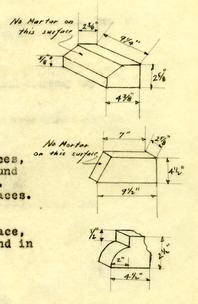
Several bricks with ground surfaces, shaped like sketch to right, were found in debris near Palace basement steps. Apparently they were used in fire places.
A fragment of brick, ground surface, shaped like sketch to right were found in screening Palace debris.
H.S.R.
Perry, Shaw & Hepburn
Williamsburg
Virginia
Attention: Mr. Parker
RE: Bricks-Governor's Palace
Gentlemen:
Complying with your request of today, the average size of the bricks in the old original Governor's Palace foundation walls is 9¼" x 4½" x 2 5/8". This average was determined from measuring many bricks in many places scattered throughout the original walls.
The range of the sizes is as follows:-
| Length: 9" to 9½" | Average 9½" and more of the bricks actually measured 9½" than any other length. |
| Width 4¼" to 4 5/8" | Average 4½". Twice as many bricks actually measured 4½" than any other width. |
| Thickness: 2½" to 2¾" | Average 2 5/8". Twice as many bricks actually measured 2 5/8" than any other thickness. |
Four courses of brick laid up actually measure 13" in height; 8 courses actually measure 26" with scarcely any variation.
I shall leave several samples of brick at the office for you, to show the range of color.
Yours very truly,
Herbert S. Ragland
RE: Governor's Palace Brick
Attention: Mr. Geddes
Perry, Shaw & Hepburn
Williamsburg
Virginia
Dear Mr. Geddes:
I am leaving at the office today a concrete slab 22" by 22" by ¾" thick in which are imbedded samples of bricks from the Governor's Palace to show the range of color and their glaze. All of these samples were taken from the original foundation and basement walls of the Palace -- walls which are still standing.
Very truly yours,
Herbert S. Ragland
RE: Governor's Palace Brick
Mr. Harold R. Shurtleff
Department of Research & Record
Williamsburg, Virginia
Dear Mr. Shurtleff:
To preserve and examine the face of the piece of fallen wall from the superstructure of the Governor's Palace, which has been lying face down on the brick walk and overhanging the drain west of the Palace foundations, I have poured concrete on the back of it, and have turned it over intact.
It was unsuccessfully done, and the face of the wall shows clearly the bond, (Flemish), the pointing (a line struck through the center of each mortar joint,) and the size of the bricks (average 9¼ x 4½ x 2 5/8" -- about 80% 2 5/8" thick, about 40% 2½ thick, and about 10% 2½ thick). The bricks are somewhat discolored and damaged by weathering, but nevertheless show fairly well the range of color, glaze and texture. (However, as this piece of wall is mall, I think the range of color and size of bricks can be more completely determined form the bricks in the foundation and basement walls, where a much greater number can be examined. Undoubtedly the bricks in the foundations and in the piece of wall from the superstructure are the same. See letter date today to Mr. Geddes about samples of brick from the foundation walls, and letter of February 4th to Mr. Parker about the bricks sizes.)
The piece of fallen wall was badly shattered by its fall when the Palace was destroyed, and consequently the mortar joints are not tight, there being practically no bond between bricks and mortar.
It was necessary, to pick up the face of this wall, to remove all the shattered and disintegrated brick on the back of it, and cut it down to a thickness of 4" except the unbroken headers, so that the concrete poured on it would pick up each brick. It did, and the face of the wall is now in the exact shape in which it was found, but held together almost entirely by the concrete backing.
I recommend that this piece of wall be placed in the basement of the old school to protect it from the weather, although it is now covered with paper. It weighs about a ton, but can be put into the basement through the automobile entrance on the west side and set up where the light can fall upon it and be easily seen.
Very truly yours,
Herbert S. Ragland
December 12, 1931
Governor's Palace
Todd & Brown, Inc.
Williamsburg, Va.
Gentlemen:
You are hereby directed to use the center and base lines and bench mark (Elevation 80.38) shown on attached drawing, (Location Plan of Governor's Palace and two flanking outbuildings, dated Dec. 11, 1931) in laying out and constructing the Governor's Palace building.
Mr. Ragland will indicate to you on the ground, the bench mark and the hubs that hold the lines. Please see that all those points are preserved.
Yours very truly,
Perry, Shaw and Hepburn
By: (Joseph W. Geddes)
HSR: MC
enc.
Copies to:
Mr. Shurtleff
H. S. Ragland
P. S. H. Boston
T & B, N.Y.
INDEX
Additions & Revisions, covering Excavations made in 1932, 1933 (which supplement this original report covering excavations 1930, 1931) In back of book
- Base Lines and Bench mark
- 59
- Bricks - Palace
- 56-57
- Courts
- Debris and Archaeological Findings
- 6-8; 54-5[illegible]
- Drains
- Drawings, List of
- 52-53
- Excavations
- 1-6
- Fallen Wall - Palace
- 38
- Foundations,
- Gutters
- Gardens - Walls, Walks, Steps, Terraces, etc
- 43-47; 54-5[illegible]
- Photographs
- 52
- Revolutionary Cemetery
- 8½
- Walls -