America the Scenic
by Graham Hood
From sketch to painting to engraving: American landscape art evolved from a British military need to chart the new terrain.
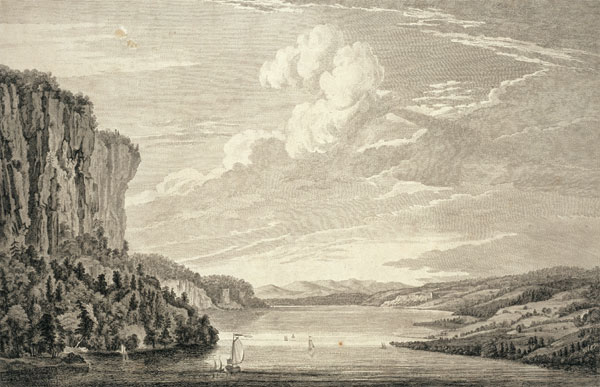
Paul Sandby translated Thomas Pownall’s sketch of the Mohawk River in New York into oil, later engraved for the Scenographia.

Captain Thomas Howdell, one of the military draughtsmen who captured the new landscape, sketched New York harbor.

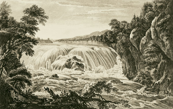
The eighteenth-century interest in the sublime can be seen in the churning waves and rumbling storm clouds of this seascape.
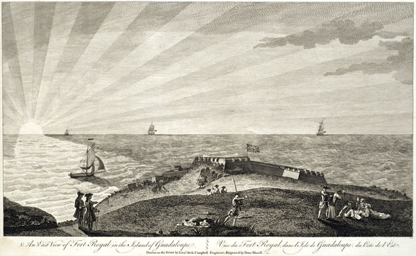
British engineers and soldiers recorded views of the New World from the Gulf of St. Laurence, opposite, to Guadaloupe.

Paul Sandby, by Francis Cotes.

Governor Thomas Pownall, by Richard Earlom, the main contributors to Scenographia Americana.
After England’s small scale and hazy air, North America’s bays and rivers seem vast, its savannahs rich, the skies magnificent, and the light magical. We might assume that the earliest explorers and colonists thought so, too, gazing awestruck about them. If they did, they wrote little about it. What awe they might have felt, they seem to have had more interest in the resources and people. Survival, of course, was paramount.
Sir Walter Ralegh’s expedition of 1585 to what is now North Carolina included an artist, John White, after the manner of the French expedition to Florida twenty years earlier, which counted Jacques Le Moyne in its company. Though all but one of the Frenchman’s drawings have disappeared, his works and White’s were engraved by the Fleming Theodore De Bry and published as early as the 1590s.
We might have expected both artists to be sensitive to the scenery, including it in their drawings. Perhaps Le Moyne did, in the drawings now lost, and it was overlooked or edited out by the literal De Bry. What we see are images of the flora and fauna of the New World, including depictions of the native people, but no attempt to convey the magnificence of the terrain.
In a sense, this is to demand of these early artists values that were not articulated in Europe for decades to come—even if this was a New World. For the century and a half following initial colonization of North America, the continent’s art was little more than the standard format of likenesses or portraits, most of which could have been done anywhere in Europe. Some of them contained landscape views as background, but mostly of a generic sort. What North America did provide during the time was treasure upon treasure of specimens for naturalists and botanists.
The landscape of America was as striking as the specimens. But it had to await the artists of the Hudson River School in the second and third quarters of the nineteenth century before, as one art historian put it, “new art for a new land” found its expression.
Or so we have believed.
It is not true.
The period of the Seven Years’ War, or the French and Indian War, as it otherwise is known, of the 1750s and ’60s, a time of change in America, saw the first artistic celebrations of its scenic wonders. This was in a volume of twenty-eight prints published in 1768, little known today, titled Scenographia Americana.
The changes in artistic sensibilities—revolution might not be too strong a word—that led to the new perceptions of nature can be seen first in Britain. From the 1740s, certain English gentlemen and their spouses began to stand back from minute scrutiny of flora and fauna and look instead at what a combination of natural elements made. In other words, they began to contemplate views. Select European artists had initiated the trend three generations earlier. Now people of leisure gazed at landscape: the more dramatic the prospect, in pictorial terms, the more their emotions were stirred and their interest stimulated. Mountains were the most impressive—mighty, upright, strong, and enduring—but hills, valleys, rivers, waterfalls, and lakes also could combine to form views satisfying to the artistic and moral senses. Intense weather effects heightened the drama.
Theories were formulated—On the Sublime and the Beautiful, published by Edmund Burke in 1757, and On the Picturesque, by Uvedale Price, which found book form in 1794. But in the production of these new views of America, two young Englishmen were influential in more practical ways. One spent seven years on the continent. The other was based in London.
Thirty-one-year-old Thomas Pownall arrived in New York in 1753 as secretary to the new governor of the province, Sir Danvers Osborne, who died soon thereafter. Two years later, Pownall became governor of New Jersey. One year after the outbreak of war in 1756, Prime Minister William Pitt sent Pownall to Massachusetts as its chief executive. His tenure there lasted three years before he returned to England, where he entered Parliament and became an influential and sympathetic commentator on American affairs.
Pownall responded with sensibility to America’s natural beauty. When he published his A Topographical Description of the Dominions of the United States of America: A Topographical Description of Such Parts of North America as Are Contained in the (Annexed) Map of the Middle British Colonies, &C., in North America in 1776, for example, he noted that “the reader may imagine that the scenes of ” the Hudson River “must exhibit some of the finest landscapes in the world; I thought so, and made many sketches.” But he also looked at the terrain in his official capacity, from the viewpoint of military strategy. The military’s need for exploration often brought more opportunities for aesthetic appreciation.
The young English artist Paul Sandby was the Londoner. Soon after joining the topographical drawing room of the Board of Ordnance, Sandby had been sent to map the Scottish Highlands in 1746. He used the opportunity to produce watercolor drawings of this scenic area. During the next decade, he and his older brother, Thomas, architect and topographical draughtsman, made views of the royal estates at Windsor, investing the forms with a lucid stillness. He later drew a series of Welsh scenes. Sandby became chief drawing master at Woolwich’s Royal Military Academy in 1768, and was one of the group of painters who petitioned George III to found the Royal Academy, which the king did.
The involvement of these two men with the military is important because it was British officials and officers in America during the French and Indian War who produced all but one of the on-the-spot drawings that were taken or sent back to London, engraved, and gathered for the Scenographia Americana. These views were not the products of professional artists, though we cannot be sure how much the professional engravers in London added to or embellished the originals.
Pownall and Sandby were the most influential contributors to the volume in numbers. Pownall lent seven of his views, most of them previously published, of which six had been etched or painted by Sandby. Sandby was involved in two other views, one of the six drawn by Captain Harvey Smyth, and one of six drawn by Elias Durnford, engineer.
We can only guess to what extent Governor Pownall used his office and his years in America to encourage other officers to produce views. The sketches of five additional men are included in the 1768 volume. And we can only guess the extent of Sandby’s influence—he was in the right place at the right time to play a role in teaching the required drawing of perspective and drawing from nature to all gentlemen cadets being commissioned in the Artillery or the Engineers.
Two enthusiasms above all influenced the choice of scenes in Scenographia Americana. One was the celebration of empire—newly expanded empire, furthermore, thanks to the military successes of the war. From the Gulf of St. Lawrence to the West Indies, the scenes include locations of battles, views of strategic provincial capitals, and newly secured areas of commercial importance.
Just as clear is the celebration of nature’s “astonishingly great” expanse, to cite Pownall, great in width and in height. Here are harbors and rivers, cascades, forests, and skies. Size was not the only consideration, however. Of one of view—“an American Settlement or Farm”—he wrote:
With what an overflowing Joy does the Heart melt, while one views the Banks where rising Farms, new Fields, or flowering Orchards begin to illuminate this Face of Nature; nothing can be more delightful to the Eye, nothing go with more penetrating Sensation to the Heart.
Almost all of the prints in the expensive, folio-sized 1768 volume had been previously published, capitalizing on the fervor the war’s victories had generated. This probably explains the presence of four of the powerhouse print-publishers of the day—Robert Sayers, Thomas Jeffrys, Thomas Bowles, and Henry Parker—and ten leading London engravers. The prints are all of commanding size, horizontal oblongs, 14" x 21" ranging to 17" x 23". When they are framed and hung, you realize how powerfully and beautifully they carry.
The men who sketched these scenes started mostly with the conventional low viewpoint of the topographical artist. This allowed a clear and accurate rendition of outline. It also resulted in ample space for atmospheric effects. The grandeur of American skies is an imposing element of this volume.
Since none of the original sketches seem to have survived, we can only guess how much this owed to witnesses on the continent rather than to artistic imaginations in London. Whichever it was, the effect is dramatic and triumphant.
Scenographia Americana also contains nine city views. Even in these, Nature predominates, whether through water, sky, hills, foliage, or some combination. They are not, for the most part, views of city buildings, streets, or squares. Rather, the distant cities nestle at water’s edge, the countryside behind them seemingly spacious and secure. The exceptions are one of two views of New York City, its buildings surrounded by rolling countryside, the Hudson River barely seen in the background; and three of four views of the city of Havana. One depicts the outer harbor. The other two focus on the city’s marketplace, and on the Franciscan church and convent.
Six of the eight views of Canada, the first in the series, were drawn by Captain Hervey Smythe, aide-de-camp to General James Wolfe, engraved by four engravers and dedicated to William Pitt. They appeared in 1760. Other than a view of the harbor and city of Quebec, and one of the Isle Percee in the Gulf of St. Lawrence, these scenes showed sites of military action. Inevitably, they included the heights that Wolfe led his troops over September 13, 1759, to rout the French army under Montcalm and effectively secure Canada.
Pownall published his Six Remarkable Views in the Provinces of New-York, New-Jersey, and Pennsylvania in 1761, soon after his return to England. Four views in the West Indies “Drawn on the Spot” by Lieutenant Archibald Campbell, Engineer, appeared in 1762 and 1764. They included a battle site in Dominica and three vistas of Fort Royal in Guadaloupe. And Six Views of the City, Harbour, and Country of Havana, drawn by Elias Durnford, engineer, aide-de-camp to the Earl of Albemarle, commander in chief of the expedition to Cuba, appeared in 1764.
Pownall must have sensed that the winter of 1767–68 was a propitious time, politically, for drawing attention to the American colonies and the successes of the recent war. As Canadian historian John E. Crowley noted:
Parliament had rescinded the miscalculated Stamp Act. First Townsend then Grafton led the way in planning new sources of revenue from and for the colonies, as well as the government officers to run these programs. And “a new Colonial Department, with Lord Hillsborough as first secretary, would provide a coherent administration for the first time.”
The intent was to better integrate the colonies into the imperial system, a move Pownall urged his fellow MPs to support. In his mind, there was no doubt that colonial representation was desirable, necessary even. But by this time, the colonists had grown impatient with the pace of ministerial reform, suspecting that all they heard, or were allowed to hear, masked tactics for placating and stalling. For many of them it was too late.
If Scenographia Americana was part of a failed effort to raise the colonies’ standing in the burgeoning empire, it was important in exposing people to American continent’s panoramas. During the next twenty years, the book was reissued and expanded, eventually comprising more than seventy views. How many copies reached American shores in the decades following its initial publication is impossible to know. It was an expensive folio volume, so it is likely the number was small. The influence of its philosophical and moral approaches to Nature, and the artistic means to convey them, were not felt in America until the 1790s. By that time, of course, these ideas and methods were widespread in England.
Whether the first of the new American practitioners saw these prints or later, more available variants is impossible to say. What is clear is that the art of depicting landscape in America after the Revolution was different from what it had been before, with the exception of the Scenographia Americana prints.
Graham Hood, Colonial Williamsburg’s vice president for collections and museums and Carlisle H. Humelsine Curator until his retirement in 1997, writes from his home beside the Chesapeake Bay. He contributed to the summer 2008 journal the essay “Changing Perceptions.”
Suggestion for further reading:
For additional discussion and an extensive reading list, see John E. Crowley’s “The Scenographia Americana (1768): A Transnational Landscape for Early America,” in the January 2006 edition of the online magazine Common-Place at www.common-place.org/vol-06/no-02/lessons/.