Captain Smith Departs
Map
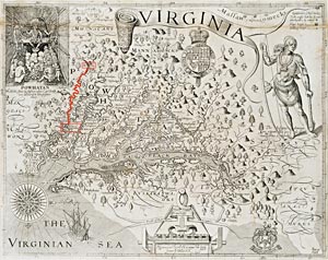
Roll over the map thumbnail to magnify.
In 1609 Captain John Smith dispatched a party of English under Captain Francis West from Jamestown—labeled “Iames-towne” on this map and fancifully depicted as settlement of tall buildings in a bend of “Powhatan flu” or the modern James—upriver to the Falls or “The Fales.” West and company were to set up housekeeping near the Indian village labeled “Powhatan,” on the site of modern Richmond, and marked with a Maltese cross. Smith followed to see how West was doing, fell into disputes with West’s men, and left them to their fates. Boating back to Jamestown, Smith suffered severe burns when a spark ignited the contents of his gunpowder pouch. On this map, taken from Smith’s “Generall Historie,” north is to the right, and west to the top.