In Search of the Frenchman's Map
by Michael J. Lombardi
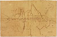
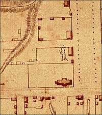
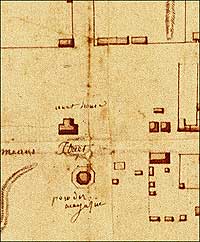
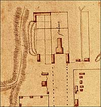
The Frenchman's Map. Courtesy of Special Collections Research Center, Swem Library, College of William and Mary
On a dark January evening in 1927 the Reverend Dr. W. A. R. Goodwin led a troop of five men through the streets of a sleepy town whose days of glory were far in the past. Armed with an old sword, a surveyor's tape, and the tracings of an antique map, they set out to do battle with history. The sword served to stake down an end of the tape as Goodwin and his mates began measuring the streets of Williamsburg searching for the foundations of America's past. Their goal was the restoration of a colonial Virginia capital. A hand-drawn copy of the Frenchman's Map told them where to look. It is part of the lore of Colonial Williamsburg, The original Frenchman's Map, a detailed view of the streets and buildings of Williamsburg drawn near the end of the Revolutionary War, is easy to find today. It is preserved with the other priceless documents of American history in the rare books room at the College of William and Mary's Earl Greg Swem Library. The map with the intriguing name, discovered between the pages of an old book, helped uncover eighteenth-century Williamsburg, a treasure more valuable than anything marked by an X on a pirate's map. But the history of the map is as mysterious as any buccaneer's chart.
After the Revolution, the map disappeared. It resurfaced more than a hundred years later in the hands of John D. Crimmins, a New York contractor and map collector. Crimmins's grandson said his grandfather had purchased a small library in Norfolk. The map was found in one of the volumes in 1909. When discovered, it was given to William and Mary, which owns it still. The college framed it neatly and hung it in the library, but not much notice was paid it. When Goodwin—a professor and fund-raiser for the college, as well as rector of Bruton Parish Church—began his quest to restore Williamsburg, he discovered the map, and recognized its importance to the restoration. He told his partner in the project, John D. Rockefeller Jr., in a January 1927 letter:
We have found an old map at the College, of Williamsburg in 1782. This map locates every house in Williamsburg at that date. It is drawn to scale, and was drawn by a French military officer. It marks the Wythe House as General Headquarters. This map will be invaluable in our study.
The map became the bible of the restoration. Or at least that is how Alan Simpson describes it in his little book The Mysteries of the "Frenchman's Map" of Williamsburg, Virginia. Simpson mostly solved the mysteries, and I've borrowed freely from him for this story.
The map has been called "The Bible of the Restoration." Was it?
Ed Chappell, the Richard and Shirley Roberts Director of Architectural Research at Colonial Williamsburg, thinks about that for a moment. He answers carefully. "It was useful to the restoration, and it has continued to be, for certain particular functions, useful. 'The bible' suggests the only source, and there are obviously many sources. One could never restore much of town simply with a map, however detailed that is. This is very detailed, like a lot of French military cartography. But it has limitations.
"The buildings and their locations are presented in a relatively precise manner, and they are to a scale to some degree, but it's a pretty small scale. And it's done in a somewhat impressionistic manner."
At this point Chappell reaches over to pick up a copy of the map to remind him of those shortcomings. After a glance he continues. "Well, I guess an example would be the Peyton Randolph House, a good example of the kind of limitations of the map. It essentially shows where the house is, but it doesn't entirely show the existing shape, and it shows none of the buildings behind it. Interestingly the only outbuilding it shows is in the far northeast corner. Way over here. "I assume the answer is they didn't quite finish it."
Could it have been a draft?
There's evidence of that, and it accounts for some of the mysteries of the Frenchman's Map. Who made the map? For what purpose? And what became of it for more than a hundred years?
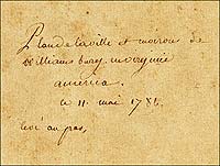
The Frenchman's Map is strikingly similar in design to billeting maps of Hampton and Yorktown drawn by Alexandre and Charles Berthier to help French troops, fresh from victory at the Siege of Yorktown, establish winter quarters in November 1781. The Berthier brothers' beautifully executed maps are more polished than the Frenchman's Map and stylistically consistent. Handwriting analysis shows the writing on the Frenchman's Map was mostly done by one person, the caption by another, and the scribbled, profane "graffiti," as Alan Simpson gently calls it, by a third. The Frenchman's Map does not look like a finished work of the Berthiers, but since many French troops were to stay in Williamsburg, it seems reasonable that the French commanders would want a finished billeting map. Perhaps the brothers were to turn the draft Frenchman's Map into one of their masterpieces of French military cartography.
If the map was a draft, it explains the caption, dated May 11, 1782. The date does not make much sense for a billeting map, since the troops moved into their winter quarters in the autumn of 1781. But perhaps a draft was filed away somewhere until a clerk jotted down a cursory description and date as the French troops prepared to leave Williamsburg the following May. The graffiti could have been added at any time.
Could it be a copy of another drawing?
There is evidence that the Frenchman's Map is a tracing. If you hold the original up to a light, pinpricks show through the paper. The pinholes were used to trace the map from an original rough draft. A second set of pinholes just offset from the first might indicate another copy was made from the Frenchman's Map. The pinhole evidence, however, is not definitive. The second set of holes is intriguing, and could have been used to make a final, more professional billeting map, but there are other explanations. Margaret Pritchard, curator of maps at Colonial Williamsburg, has seen two sets of pinholes in other maps. The second set does not necessarily mean a copy was made. It might indicate an adjustment in the scale from the first draft, or that two sources were combined to create the map. Both are possibilities.
Paul Buchanan, who preceded Chappell as director of architectural research at Colonial Williamsburg, noticed that the horizontal and vertical scale differed on the Frenchman's Map. Simpson speculated that the Frenchman who drew the map had help from one of his American allies pacing off the distances. The difference in scale is attributed to the different length of the pace of the two surveyors. If there was a finished version of the Frenchman's Map that corrects this discrepancy, there is no record of it.
Who was the Frenchman?
There is no record of the Frenchman's identity. Simpson focuses on a handful of assistant quartermasters who were assigned "to establish lodgings for the French Army, which was immediately to take winter quarters and to occupy the towns of Williamsburg, Hampton, Yorktown, and Gloucester." But without a signature, or a definitive stylistic or handwriting correlation, Simpson's search ends with a list of four or five French officers who had the skills to create this kind of a map. Pritchard and Chappell said further research might narrow that down. Pritchard said she suspects that if someone "took a trip to Paris, they could probably find more information."
Chappell said, "It is conceivable that one could match up the watermarks on the paper, or the handwriting, and perhaps combine it with style. They have great collections of French cartography in France, so I would think another step would be to really look at the French collections."
What became of the map when the French decamped?
If it may be possible to discover more about the map's author, it is unlikely we will ever know what happened to the map after the French left Williamsburg. Perhaps it was left behind as the troops departed, or given as a gift to an American ally. Perhaps it was simply tucked away in a book and forgotten until discovered by John Crimmins.
How did Goodwin come by a copy?
Architects and archaeologists of the restoration were eager to reproduce the map. That was not so easy. Earl Gregg Swem, the college's librarian, had little use for the idea of the restoration. Following standard practices, he initially refused to allow the map to be photographed. Goodwin asked his assistant, the Reverend John B. Bentley, who got along with Swem and could draw a map, to try to persuade the librarian to allow him to make a copy. Bentley wrote:
I went to see Dr. Swem, and he received me courteously—I can't say warmly—he frowned and scowled and hesitated, but as time went by, he relented. Finally he said that I might copy the map if I did it in the library ...provided I didn't put a pencil or tool of any sort on the map itself and would assure him that it would suffer no harm.
How useful to the restoration was it?
That copy and the blueprints made from it may not have been the bible of the restoration, but Chappell said the map was vital to the early restoration. "When they were primarily looking for foundations archaeologically, they weren't trying to find every find, and analyze every archaeological feature. They were really trying to find the buildings that were there and put them back, and this was exactly the period you want to know about.
"It is quite accurate but slightly stylized. Some of the remarkable things it includes are the catalpa trees on Palace Green, the trees around the Custis block, the peculiar fence arrangement at the Nicholas Tyler House..." Well, you get the picture. Surely, these details were not needed for a billeting map. Chappell said he believes that the "Frenchman" simply got caught up in the assignment. "In some ways it's like Bridge over the River Kwai. In the military you get put on a job, and you do it come hell or high water, and it isn't tightly keyed to the explicit needs of the army." The exceptional detail is contradicted by the sparsity of labels. The spotty identifications, some in English and some in French, are often incomplete or use incorrect names. Chappell said some of the most intriguing elements of the map are not labeled at all. "No one really knows what this great L-shaped building at the back of the Governor's Palace is. Archaeologists really struggled with that during the thirties. They found some stuff, but it was ambiguous. If that had had a little label, it would have been very helpful."
Perhaps the lack of labels argues in favor of the draft theory. Perhaps a finished version was made and used during the time the French troops quartered in Williamsburg.
Could there be a beautifully illustrated, well-labeled version of the Frenchman's Map, hidden away in a dusty corner of some French chateau?
Margaret Pritchard believes that's possible. "Absolutely...It wouldn't surprise me at all. Some of the best Indian artifacts went back with all of these officers after the French and Indian War. Certainly, after the Revolution, you know that the French took some of these things back with them. It could be in any family's papers, not just the Bibliothèque Nationale. Any of the descendents of the French officers could have ended up with some of that material."
Historian Harold Gill points out, however: "Just because the writing is in French doesn't necessarily mean a Frenchman wrote it." Some notations are in English, he said, possibly from the hand of an American who knew French.
Perhaps, someday, someone will solve the remaining mysteries of the Frenchman's Map. Until then, Pritchard said, "The Frenchman's Map does provide you with a capsule of what was standing at that particular time. It's the closest thing we have to provide a picture of what the town looked like then."
Michael Lombardi is a Williamsburg video and film producer and director. He contributed a story about the technology of history to the autumn 2006 journal.
Suggestion for further reading:
- Alan Simpson, The Mysteries of the "Frenchman's Map" of Williamsburg, Virginia (Williamsburg, VA, 1984).
- For an online image of the map: http://swem.wm.edu/departments/special-collections/exhibits/exhibits/Sampler/main.html

