Peyton Randolph House Architectural Report, Block 28 Building 6Originally entitled: " Building An Image: An Architectural Report on the Peyton Randolph Site"
Colonial Williamsburg Foundation Library Research Report Series - 1542
Colonial Williamsburg Foundation Library
Williamsburg, Virginia
1990
 Portrait of Peyton Randolph
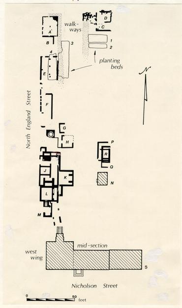 Figure 1 - Site Plan of all excavated features on lot 207, north of the Peyton Randolph House. Drawn by Natalie F. Larson, CWF, 1984.
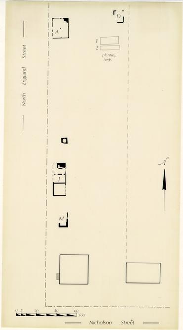 Figure 2 - Archaeological features thought to date to the first period of development. Drawn by Natalie F. Larson, CWF, 1985.
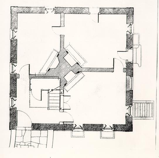 Figure 3 - First Floor Plan, Mount Airy southeast dependency. Measure by Charles Bergengren, S. Allan Chambers, Edward A. Chapell, Willie Graham, Mark Schara and Douglas Taylor. Drawn by Mark Schara and Douglas Taylor, CWF, 1981.
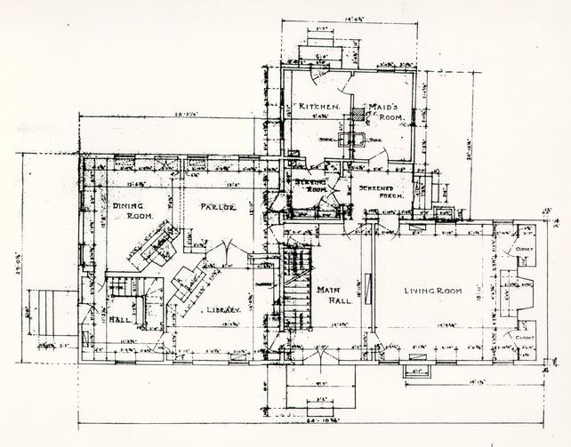 Figure 4 - First-floor plan of Peyton Randolph House as it existed before restoration. Drawn by R. A. W. (probably Richard Walker), CWF, 1938.
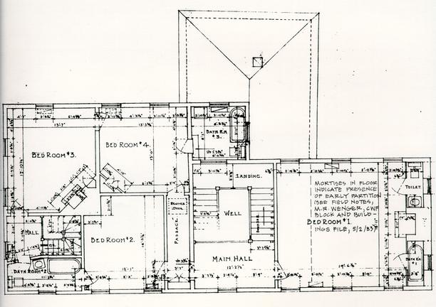 Figure 5 - Second-floor plan of Peyton Randolph House as it existed before restoration. Drawn by R. A. W., CWF, 1938.
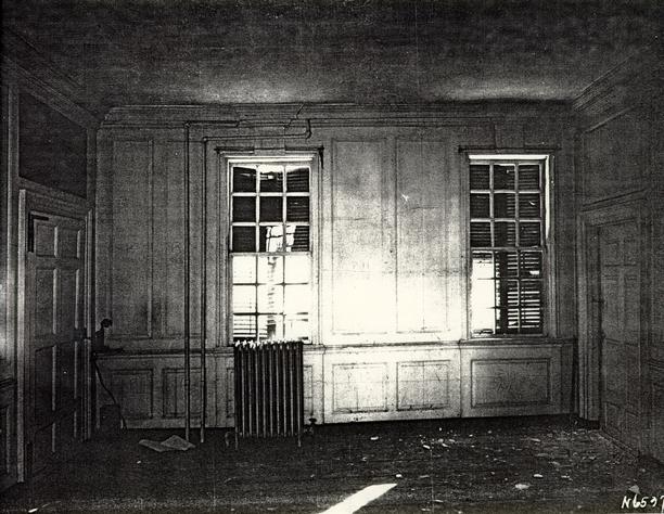 Figure 6 - Pre-restoration photograph of the south elevation of the first-floor southeast room in oldest section of Peyton Randolph House. Photographer unknown, CWF, circa
1938.
Figure 6 - Pre-restoration photograph of the south elevation of the first-floor southeast room in oldest section of Peyton Randolph House. Photographer unknown, CWF, circa
1938.
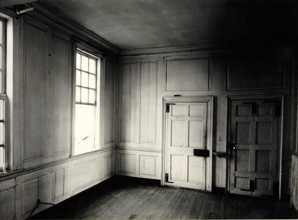 Figure 7 - Pre-restoration photograph of north and east wall elevations, first floor northeast room, Peyton Randolph House. Photographer unknown, CWF, circa
1938.
Figure 7 - Pre-restoration photograph of north and east wall elevations, first floor northeast room, Peyton Randolph House. Photographer unknown, CWF, circa
1938.
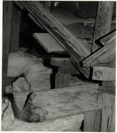 Figure 8 - Tar-lined oak gutters servicing original roof system. Douglas Taylor, CWF, 1982.
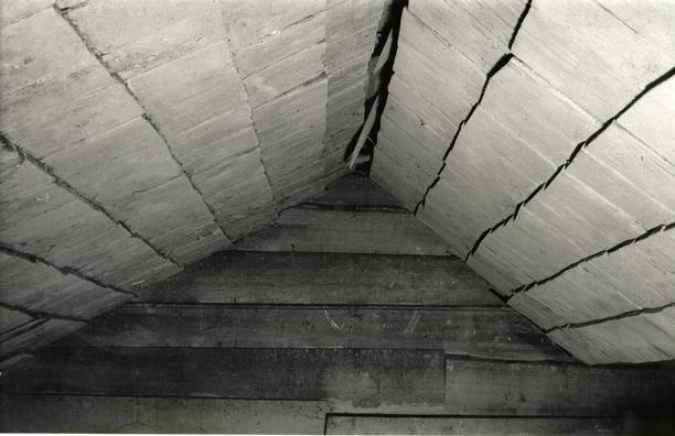 Figure 9 - Original multi-ridge roof with square-butt shingles. The tarred clapboard and weatherboard wall is coped over the shingles without the use of flashing. Original roof enclosed by period-two roof. Edward A. Chappell, CWF, 1982.
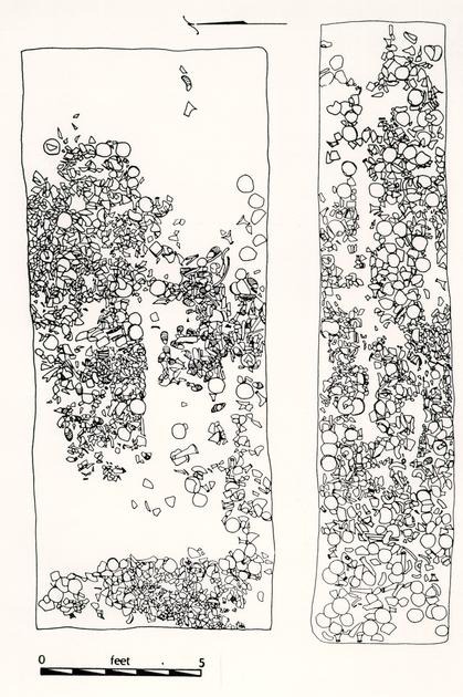 Figure 10 - Archaeological drawing of planting beds one and two. Beds were lined with bottle, ceramic and bone fragments, as well as oyster shells. Drawn by Natalie F. Larson, CWF, 1983.
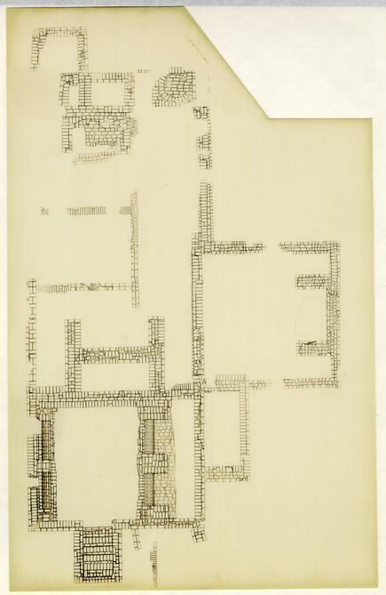 Figure 11 - Foundations for Structures J, K, and L. Drawn by Natalie F. Larson, CWF, 1985.
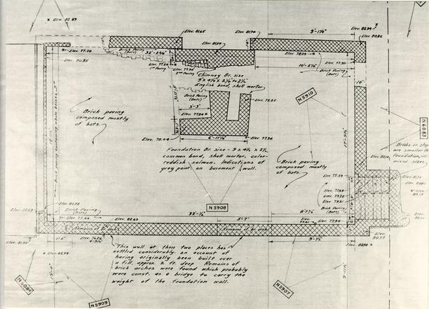 Figure 12 - Foundations for Structure S. Drawn by James Knight, CWF, 1938.
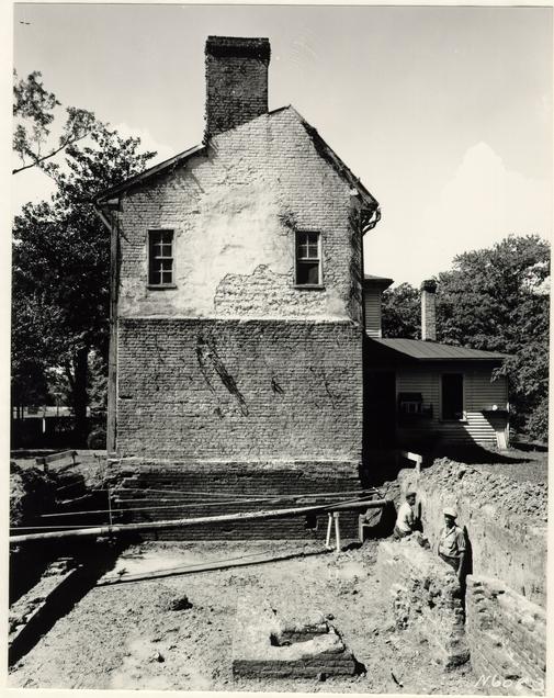 Figure 13 - East facade of period-two addition to Peyton Randolph House looking across the excavated foundations of Structure S. Plaster on wall reveals outline of roof from structure S. Photographer unknown, CWF, 1938.
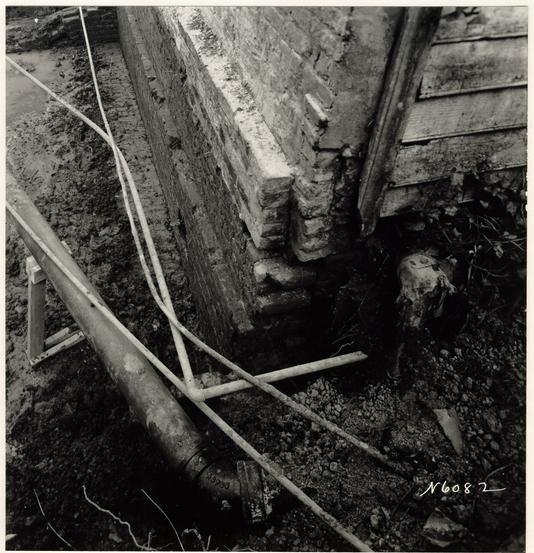 Figure 14 - Northeast corner of Peyton Randolph House showing foundations of Structure S below those of house. Photographer unknown, CWF, 1938.
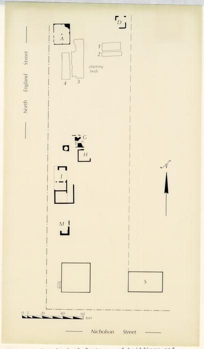 Figure 15A - Archaeological features of buildings and planting beds thought to have existed during Sir John Randolph's ownership. Drawn by Natalie F. Larson, CWF, 1985.
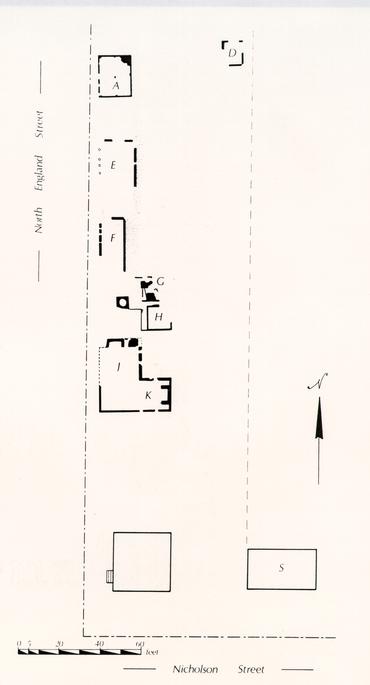 Figure 15B - Archaeological features thought to have existed circa
1740. The dating of Structure F is highly speculative. Structure E might also have been constructed at mid-century. Drawn by Natalie F. Larson, CWF, 1985.
Figure 15B - Archaeological features thought to have existed circa
1740. The dating of Structure F is highly speculative. Structure E might also have been constructed at mid-century. Drawn by Natalie F. Larson, CWF, 1985.
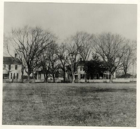 Figure 16 - Early twentieth-century photograph of the Peyton Randolph House from the southwest. A late-nineteenth century windmill over the well, a smokehouse (Structure H), a dairy (Structure P), the main house, and an unidentified outbuilding located in an unexcavated area are all visible. Photographer unknown, CWF.
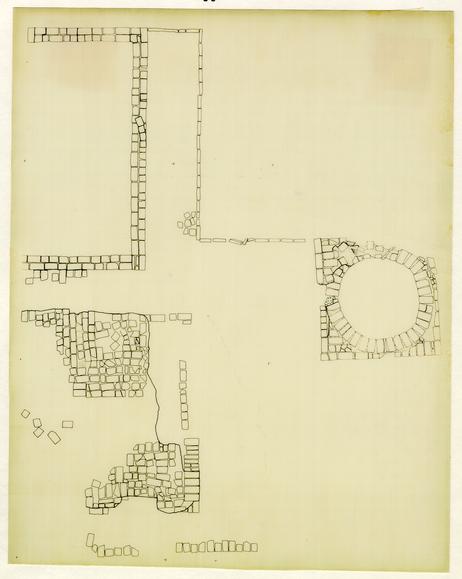 Figure 17 - Archaeological drawing of the appendage to Structure H. Drawn by Natalie F. Larson, CWF, 1984.
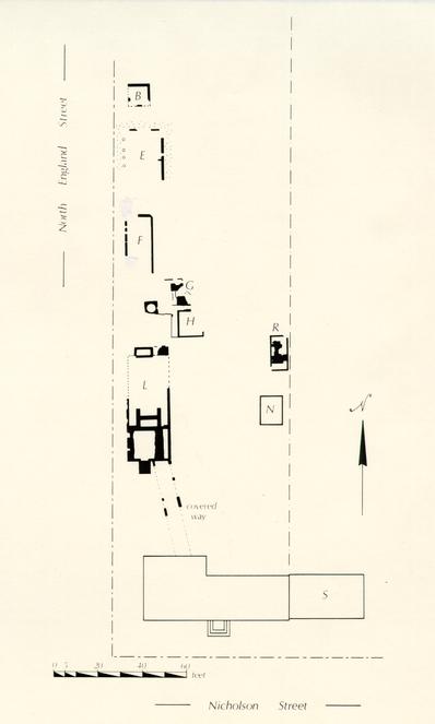 Figure 18 - Archaeological features thought to have existed during Peyton Randolph's ownership of the site. Note that the house was enlarged in this period, and that a substantial amount of rebuilding took place in the yard. Drawn by Natalie Larson, CWF, 1985.
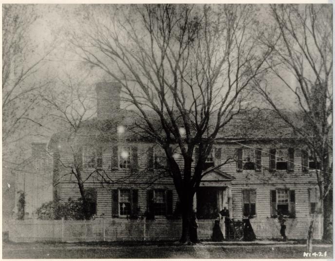 Figure 19 - Pre-1870's photograph of the Peyton Randolph House showing an eighteenth or early nineteenth-century porch, the original chimney stack to the house, and the building that served as the kitchen, laundry and servants quarter. Photographer unknown. Copy from CWF Library files.
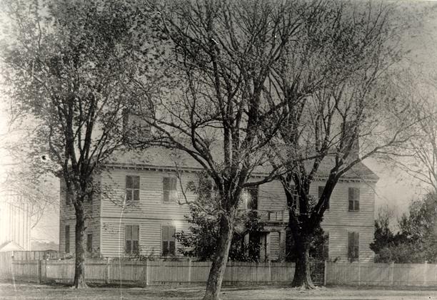 Figure 20 - Photograph of the Peyton Randolph House, identified as dating to the 1870s. Note the replacement front porch and the kitchen to the west. Photographer unknown. Copy from the CWF Library files.
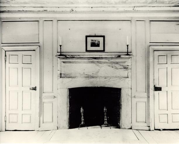 Figure 21 - Pre-restoration photo of east wall elevation of the first floor east room, Peyton Randolph House. Photograph by Metropolitan Engraving Company, Richmond, Virginia circa
1930.
Figure 21 - Pre-restoration photo of east wall elevation of the first floor east room, Peyton Randolph House. Photograph by Metropolitan Engraving Company, Richmond, Virginia circa
1930.
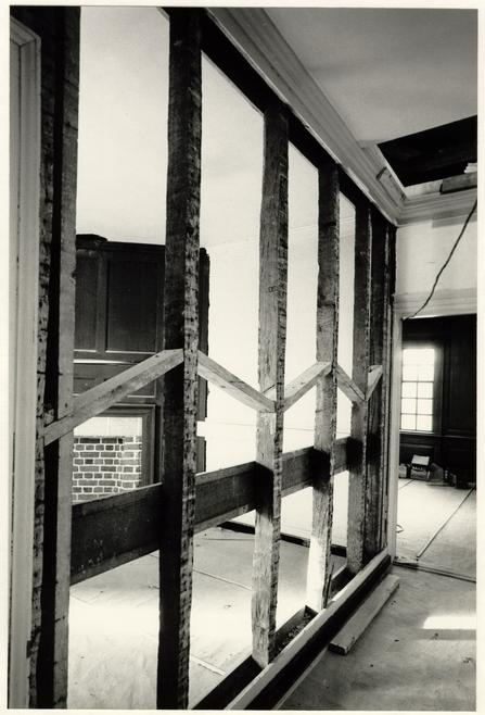 Figure 22 - Photograph of the demolition of the passage partition in the second-floor southeast chamber, oldest section of the house. S. M. T., CWF, 1968.
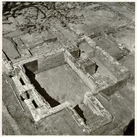 Figure 23 - Aerial view of the archaeological remains of Structure L from the southwest, showing the vaulted cellar and bulkhead cellar entrance. Andrew Edwards, CWF, 1984.
 Figure 24 - Archaeological plan of Structure E. Drawn by Natalie F. Larson, CWF, 1984.
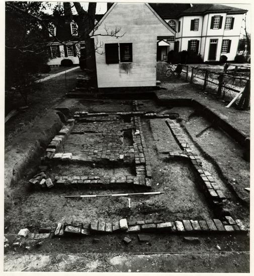 Figure 25 - Photograph of the remnants of Structures P, Q, and R from the north. Roy Jackson, CWF, 1984.
 Figure 26 - Section through Elm Grove dairy, Southhampton County. Entrance to the small storage room on the left is through the larger room. Measured by Willie Graham, Mark Schara, Sallie Smith and Douglas Taylor. Drawn by Sallie Smith, CWF, 1982.
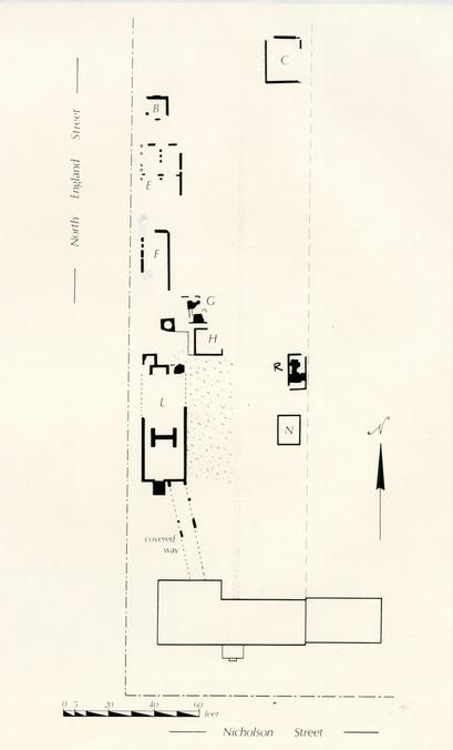 Figure 27 - Archaeological features thought to have existed during the ownership of Joseph Hornsby. Drawn by Natalie F. Larson, CWF, 1985.
 Figure 28 - Early twentieth-century photograph, subject identified as outbuildings at the Peyton Randolph site. If they are at this site, the building to the left is likely a late eighteenth- or early-nineteenth-century dairy (Structure P). No foundations were discovered for the pyramidal roof building on the right. If the image has been accidentally reversed, this building may have been located in an unexcavated area. Photographer unknown, copy by Paul Buchanan, in CWF Library.
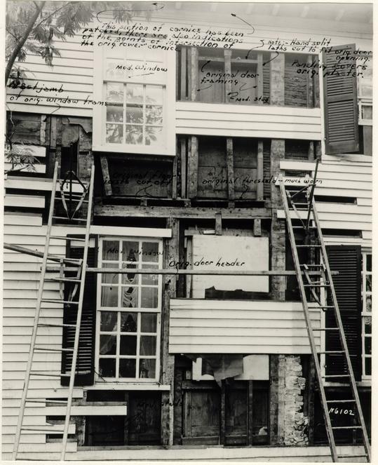 Figure 29 - Framing from north wall of house with notes by A. Lawrence Kocher. Openings to the porch tower were aligned vertically between windows. Photographer unknown, CWF, 1939.
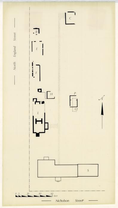 Figure 30 - Archaeological plan of the site as it appeared in the early-nineteenth century. Structures P and Q and the porch tower possibly were built late in the eighteenth century, but probably existed into the next century. Drawn by Natalie F. Larson, CWF, 1985.
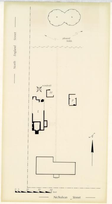 Figure 31 - Archaeological plan of the site, second half of the nineteenth century. Drawn by Natalie F. Larson, CWF, 1985.
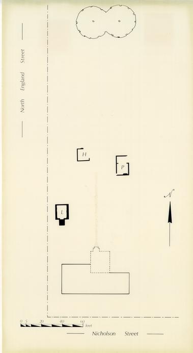 Figure 32 - Archaeological plan of the site, early twentieth century. Drawn by Natalie F. Larson, CWF, 1985.
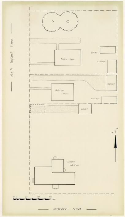 Figure 33 - Archaeological plan of the site, circa
1920-1938. Drawn by Natalie F. Larson, CWF, 1985.
Figure 33 - Archaeological plan of the site, circa
1920-1938. Drawn by Natalie F. Larson, CWF, 1985.
BUILDING AN IMAGE:
AN ARCHITECTURAL REPORT ON THE
PEYTON RANDOLPH SITE
Willie Graham
Department of Architectural Research
Assisted by Andrew C. Edwards
Office of Archaeological Excavation
Colonial Williamsburg Foundation
November, 1985
CONTENTS
| Acknowledgements | 1 |
| Introduction | 2 |
| Early Development of The Site | |
| First-Period Buildings on the Site | 8 |
| Main House | 11 |
| Structure A (Dwelling) | 27 |
| Structure D (Smokehouse) | 30 |
| Planting Beds One and Two | 32 |
| Structure J (Dwelling) | 34 |
| Structure M (Kitchen) | 37 |
| Well | 38 |
| Structure S (Dwelling) | 39 |
| Accumulation of Outbuildings | |
| Sir John and Lady Susannah's Tenure | 47 |
| Book Presses | 50 |
| Planting Beds Three and Four | 51 |
| Structure G (Dairy) | 52 |
| Structure H (Smokehouse) | 54 |
| Appendage to Structure H | 57 |
| Structure J Revisited and Structure K (Kitchen) | 59 |
| Structures F1 and F2 | 61 |
| Reordering the Site | |
| Peyton Randolph's Period | 62 |
| Expansion of the Main House | 67 |
| Structure L (Kitchen, Laundry, Servants Quarters and Forge) | 82 |
| Covered Way | 88 |
| Structure E (Granary) | 90 |
| Structure B | 94 |
| Structure R (Dairy) | 96 |
| Structure N | 101 |
| Betty Randolph | 103 |
| Maintaining the Site | |
| Joseph Hornsby's Period | 106 |
| Structure E (Granary) Repair | 108 |
| Structure C | 110 |
| Structure Q | 111 |
| Structure P (Dairy) | 112 |
| Porch Tower, Main House | 115 |
| Decline of the Site | |
| The Nineteenth Century | 119 |
| The Early Twentieth Century | 123 |
| Recommendations | 129 |
| Footnotes | 134 |
| Appendixes | |
| I: Paint Layers | 141 |
| II: Peyton Randolph Inventory | 144 |
| III: Humphrey Harwood Ledger Accounts with Betty Randolph | 149 |
| IV: Humphrey Harwood Ledger Accounts with Joseph Hornsby | 151 |
ACKNOWLEDGEMENTS
In preparing this report, I am grateful for the assistance and advice I received from others. First and foremost, I would like to thank Andrew C. Edwards for briefing me on the history of the site and its examination by the Department of Archaeology and the office of Archaeological Excavation. All of the archaeological data used in the report came from his draft report on the site and from our discussions. Marley R. Brown, III, along with Andrew, provided helpful discussions about the interpretations of each feature and assisted in developing a framework for the analysis. I would like to especially thank Natalie F. Larson for providing the archaeological drawings from the recent excavation. Edward A. Chappell, in addition to editing several drafts of the report, helped in analyzing and interpreting the complexities of site development. Mark R. Wenger and Ronald L. Hurst shared their knowledge of house plans, inventories and libraries, and Orlando Ridout V, helped us unravel the mysteries of structures J, K and L. I am also indebted to Vanessa Patrick and George Yetter, who reviewed the final draft, and to Helen Tate, Gwen Miller, and my wife Karen, who typed the report.
INTRODUCTION
Excavations on lots 207 and 237, located on the corner of Nicholson and North England Streets in Williamsburg, were begun in 1939 by the Colonial Williamsburg Architectural Department. Analysis and restoration of the house and the reconstruction of two buildings began in 1939.1 Francis Duke directed the excavations and wrote the corresponding archaeological report, while James Knight did measured drawings of the excavated features and interpreted them.
The site was excavated three other times. in 1955, a somewhat more orderly approach was taken to the archaeology by the use of crosstrenching. Crosstrenching was carried throughout the rest of lot 207, but apparently lot 237, north of the reconstructed east wing, remains largely undisturbed to this day.
During the winter of 1977-78, the Department of Archaeology, under the direction of Ivor Noël Hume, reexcavated part of lot 207. This project was important in that, for the first time on this property, stratigraphic sequences were carefully analyzed.2
Most recently, careful excavation has beep continued by the Office of Excavation, under the direction of Marley R. Brown, III, and Andrew C. Edwards. Except for an area in the center section of the lot, the site was thoroughly 3 reexamined between its northern end and the kitchen (fig. 1). The unexcavated area is primarily that under the present driveway and the sites of two 1920s houses.
Because the site had previously been opened, stratigraphic relationships were difficult to establish. However, enough information was retrieved to help establish some relative dates, construction sequences, building functions, and structural techniques, and to either prove or dispel previous theories about the site.
Through a study of the new archaeological evidence and a reexamination of documentary sources, several construction patterns for the site have been identified. In its earliest phase, lot 207 probably consisted of the main house, structure J (a hall/chamber center-passage house), and structure A (a one-room house), all of which were adjacent to and faced North England Street. Structure M seems to have served as a kitchen for the main house and structure D served as an outbuilding to A. At about the same time, a lobby-entrance house designated as structure S was constructed on lot 237, facing Nicholson Street. Structures A, J and S appear to be rental property rather than support buildings for the main house.
The ownership of the two lots passed from William Robertson to John Holloway and then to John Randolph by 1724. 5 Some changes and additions were made during his ownership, but it was not until Randolph's son, Peyton took control of the site that major alterations were made. During the mid-eighteenth century, Peyton reoriented the main house, added a large addition to the east containing a new entertaining room, chamber and large central passage, and gave the building the appearance of a substantial, seven-bay Georgian house. The other dwellings on lot 207 were either torn down or were already gone by this time. A large walkway was installed down the center of the rear yard and new outbuildings were constructed flanking and facing the walkway, in contrast to the earlier orientation of buildings. The most substantial of these new outbuildings was a structure, possibly two stories high, that served as kitchen, laundry and servants quarters. A vaulted cellar was located under the southern portion, and the building was connected to the house by a hyphen. At the same time, a substantial amount of alterations were made to the interior of the house. These changes reflected not only a desire for up-to-date interior trim, but also an intention to introduce different room functions that were becoming fashionable in the mid-eighteenth century.
Throughout the rest of the century, the property was well maintained and all new construction related to the site order established by Peyton Randolph. The property was acquired by the Peachy family about 1800, and the house was 6 eventually turned into a boarding house. By mid-nineteenth century, most of the outbuildings in the rear had been demolished. The kitchen (structure L), smokehouse (structure H), dairy (structure P) and well survived into the late nineteenth or early twentieth century, as is evident in photographs of the site. By the 1920s, however, all eighteenth-century buildings had been demolished, except the main house.
EARLY DEVELOPMENT OF THE SITE
FIRST-PERIOD BUILDINGS ON THE SITE
In 1714, the Trustees of Williamsburg conveyed to William Robertson of York County a series of lots in Williamsburg. No contemporary plans survive that indicate lot numbers, but by reviewing a series of related deeds, tentative conclusions can be reached as to where these lots were located.3 Of the six lots conveyed to Robertson, this report concerns itself with the architectural development of what is thought to be adjacent lots 207 and 237. With its length running north and south, lot 207 appears to be that on the corner of North England and Nicholson Streets, the site of the main house and its mid-eighteenth century addition. Lot 207 probably extended northward to include structure A. Lot 237, then, would be immediately to the east.
The main house was constructed sometime between 1715 and 1723 and still in large part survives. At the same time the main house was constructed, or shortly thereafter, several other buildings were added to the site. As the site has been previously excavated, dating of features was fairly difficult. However, examining what stratigraphic and artifactual information remained, patterns of development on the rest of this lot, and partially on lot 237, became evident.
A series of buildings were constructed to the north of the main house during this period, most of which seem to 9 have been oriented towards North England Street. These features include structures A, D, J, M and S (commonly known in CWF reports as the "so-called east wing"), and probably the well (fig. 2). Structures A, J and S share some common features, and they may all have been dwellings. Structure M likely served as the kitchen for the main house, and structure D appears to have been some type of outbuilding for structure A, possibly a smokehouse.
MAIN HOUSE
The western portion of the main house has traditionally been dated to circa 1715. Typically, the deed transferring the eight lots to Robertson conditioned the sale, stating:
that if the said William Robertson his heirs or Assigns shall not within the space of Twenty four Months next Ensuing the date of these Presents begin to build & finish upon Each Lott of the said granted Premisses one good Dwelling house or houses of such dimensions and to be placed in such manner as by Once Act of Assembly . . . then it shall & may be lawful to & for the said Feoffers or Trustees . . . to have again as their former Estate to have hold & Enjoy in like manner as they might otherwise have done if these Presents had never been made.4
Whether or not Robertson complied with this stipulation in the required time is not known, but other evidence indicates that the house was built by the early 1720s at the latest.
In 1983-84, the American Institute of Dendrochronology was contracted to date the construction of the house using the key-year technique developed by H. J. Heikkenen.5 Tentative dates were established for the felling of trees used to fabricate some framing members and the oak gutters.6 Plates that carry part of the multiple-peaked roof and attic joists dated to 1715. Period-one rafters yielded a date of 1716 and the oak gutters came in at 1718. Problems related to analyzing tulip poplar samples, the lack of an adequate tulip 12 poplar area pattern, and short tree ring patterns combined to cast some doubt on the accuracy of these figures, but they seem to fall within the range of the traditional construction date for the house. The date derived from the oak gutter is reassuring in this regard.
On December 12, 1723, Robertson conveyed lots 236, 237, 207 and 208 "whereon the said William Robertson's Windmill stands together with the said Windmill and all Houses buildings Yards Orchards ways Waters profits Easements & Commodities . . . ." to John Holloway of the City of Williamsburg.7 Not long after this transaction, John Randolph acquired a lot, presumably number 207, from Holloway and moved his family into a house on the property.8 It can be deduced, then, that the construction of the house might have begun as early as 1715 or 1716, and it appears to have been up at least by the end of 1723. The house began as a relatively square, two-story frame building. Facing North England Street like most of the early buildings on the lot, it was constructed as a three-room-plan house with a corner passage. By arranging the three rooms and passage around a central chimney, the builder solved the problem of how to contain these spaces in a rather interesting manner.
In the early eighteenth century, the use of a passage as well as the expansion of the typical first-floor plan to include three rooms was in its early days of 13 development. This plan is similar to that of the mid-century Seven Springs in King William County and Mount Airy's southeast dependency in Richmond County (fig. 3). Following the conventional model of the period, one would expect the southeast room, with direct access to the passage, to be a hall.9 This room is not only the largest, but best finished room of the house. Diagonally across from it, also with direct access to the passage, was likely located the dining room. Finally, the rear corner room, without access to the passage but connected (most importantly) with the dining room, was the chamber. The use of a passage added a level of privacy that most earlier and many contemporary houses did not enjoy. By adding it, greater control was provided for circulation to the more formal rooms, and the chamber was further buffered from the public (fig. 4).
If the first-floor layout provided a reasonable solution to this type of plan, the second floor did not. The northwest and southeast chambers had direct access from the passage. Entrance to the northeast room, though, was gained through another chamber (fig. 5). The surprising feature of the second floor is the superior treatment of this northeast room. Not only was it the only second-floor room provided with above-chair rail panelling, it was unique in that oak, apparently unpainted, was selected for the task. How these rooms were used is unclear, as the more typical arrangement of second-floor rooms during this period amounted to a series 17 of plain and relatively undifferentiated spaces. The possible uses for this room range from simply a superior second-floor bedchamber to it serving as an anteroom associated with the room to the south.
Part of the early interior treatment of the house is known. The woodwork in the hall appears to be original and was certainly installed before the mid-century changes to the house. Room-height raised panelling with a boxed cornice encircles the room. As in all first-period rooms, the angled fireplace walls have been reconstructed. Cut through the bolection architraves of the windows (the only bolection molding to survive in the house) are square blocks with ovolos and flat panels. Above these panels the cornice breaks out, giving the effect of a keystone over each window (fig. 6). When the east window was removed in the mid-eighteenth century, the cornice over the window was not altered. At that time, a raised panel replaced the window, resulting in odd spacing for the panels on the wall. A new stile was added to the left of this panel, and it breaks through the top rail, indicating that the panelling, as well as the cornice, was installed before mid-century. Panels below the windows in the room, like those in the other rooms with early finishes, project from the wall. As one would expect of the hall, this is the most elaborately treated room in the house.
19The dining room originally was plastered. 10 Later, probably mid-eighteenth century, room-height panelling was installed over the plaster.11
The first-floor chamber contained room-height panelling with a box cornice. Having been heavily altered over the years, much of the panelling, chair rail, baseboard and door and window trim in this room is modern. The woodwork in the room appears to fit the pattern of the other early woodwork in the house, and there is no visible evidence that the panelling is later. It does seem unlikely, however, that the dining room, being a more public room, would have originally been plastered and that the chamber would have received full-height panelling. Further investigation should be pursued to determine the date of the chamber panelling.
A prerestoration photograph of the east wall elevation of the first-floor chamber (fig. 7) shows what appears to be an eighteenth-century doorway relocated for use as an entrance to the circa 1900 wing that was added to the rear. Since two interior doorways were removed from this room in the nineteenth century when wide openings were installed, this may represent one of them. Having a six-panel door with ovolos and flat panels on the room side surrounded by a three-part architrave, this differs from what was reconstructed for the two missing doors. Instead, bolection moldings similar to the early window surrounds in the hall were used.
21The first-floor stair passage contains no panelling and retains only part of its original trim. An original pair of follicated H and L hinges remain in place on the door below the stair. Most other early hardware throughout the house does not survive. Some fragmentary three-part door architraves still remain in this room. The top member, a cyma recta with a small bead, appears to be from the first period of the house. Used also in the second-floor northwest chamber, the same early architrave survived later alterations to the room. The date of these architraves is significant in dating the woodwork of some of the second-floor rooms. Like the other first-floor rooms, the passage contains a box cornice.
The second floor was greatly altered in the mid-eighteenth century. The passage received panelling below the chair rail, the southeast chamber had stiles and rails installed to carry wallpaper, and room-height panelling was placed over the earlier plaster walls in the northwest chamber. However, much early woodwork remains in the northeast chamber. It is the only room on the second floor to contain a box cornice, and its woodwork is of unpainted oak. Eventually, probably in the eighteenth century, the woodwork was painted, either to change its status to a less important room or simply to achieve a neater appearance.
The oak chamber has room-height raised panelling with a very flat profile for the panels. Two-part door 22 architraves were installed on the inside, with three-part architraves on the opposite side. The backbands on both sides are similar to those found in the first-floor stair passage, with the northeast room side being made of oak. It seems evident, then, that the panelling in this room was installed before mid-century.
Singleton P. Moorehead did paint analysis on the woodwork in each room.12 Except in the second-floor northeast (oak-panelled) room, all eighteenth-century woodwork, including later changes, exhibited red primer as its bottom coat. With the exception of the second sequence for the first-floor northeast room, the second coat (or first finish coat) was either gray or buff. This may prove a valuable tool for determining relative dates of woodwork installation. In addition, it suggests that the oak panelling in the second-floor room might not have originally been painted. The room's first coat of paint was buff or gray and may relate to the second finish coat of paints in other contemporary rooms.
The house being square in plan, the builder faced an unusual problem in designing a roof system. What he settled on was a multi-peaked roof structure which from the exterior appeared to be a version of a hipped roof topped with a flat deck. The chosen system was an alternative to a very large gable or pyramidal roof and may reflect both an economy of material and an aesthetic related to buildings of this depth.
23The Robert Carter house displays a similar system; the dependencies at Mount Airy reveal a different angle of the roof towards its peak forming a mansard-like roof, for the same reason. The James Geddy House, although not square, offers the same appearance when viewed from the south and west, its main facades.
At the two interior valleys of the roof, oak gutters lined with pine tar were installed to carry the water runoff (fig. 8). At both the east and west ends of this roof were interior walls covered with a mixture of unpainted riven clapboards and beaded and unbeaded weatherboards. Now protected by a later roof, the four interior planes still retain their early square-butt shingle roof (fig. 9). The combed ridge remains intact, providing a unique opportunity to study how a ridge was sealed from the weather. Where the shingle roof meets the walls, clapboards and weatherboards were cut out to fit tightly over the profile of the shingles. The walls were tarred, but there is no evidence for flashing between them and the roof covering.
Whether or not a square-butt shingle roof was used on visible surfaces is not known. The overwhelming majority of extant eighteenth-century shingle roofs on other surviving mid-century or later buildings have round-butt shingles.13 It appears that square-butt shingles may have become fashionable in the third quarter of the eighteenth century when a 26 cleaner aesthetic was in vogue. In the late nineteenth century, a square-butt shingle roof at the Randolph House was covered over with a standing-seam tin roof. our only evidence for the shape of visible shingles is from the hidden portion of the roof. It is possible that the visible roof utilized round-butt shingles and that, as an effort to economize on labor, square butts were used in hidden areas. However, if they were used on the outside, one might expect to find leftover round-butt shingles used on the interior, and no such evidence is present.
During initial excavation, the first-period stair foundation to the main (west) door was uncovered. In addition, a series of bulkheads corresponding to two separate cellar openings on the north, as well as the foundations for a later porch tower were found. The only one of these features that seems to have been contemporary with the construction of the house was the smallest central bulkhead foundation, sitting below foundations related to the covered way. Steps apparently led to a partially-excavated cellar, but no physical evidence of these steps survives.
STRUCTURE A (DWELLING)
In the northwest corner of the rear lot is a 16' x 20' foundation for a frame structure with an angled fireplace in its northeast corner. Earlier thought to have been Sir John Randolph's law office and later Lady Randolph's dower house, the building is now believed to have begun life as a dwelling. Artifacts from the occupation layer were primarily domestic debris, including a large amount of tea and tablewares apparently dating to the earliest period of the building's existence. In addition, very few craft or work-related items were found, suggesting that the structure initially served a domestic function and never had an extended life as a kitchen or craft building.
Brick piers with interstices filled by contemporary one-brick-thick walls supported a 4½" tall sill. Although the piers were bonded with shell mortar, the walls were partially dry laid. Rowlocks were laid below the piers to help span a seventeenth-century drainage ditch that ran diagonally across the site. A central row of piers likely supported a north-to-south summer beam. Several rows of nails were discovered that probably were used to secure floorboards in place. These nails indicated that floor joists were set approximately two feet on center and ran east to west.
28The corner fireplace was constructed of bricks that were different in appearance from those used in the foundations. Not enough brick remained to determine bond patterns. Brick infill between the chimney walls and the building walls were partially laid in mortar over the sills. Although the sill has long since rotted away, its impression remained in the masonry. The brick infill was not mortared to the chimney sides. on top of fill containing ash, mortar, plaster, brick and a fragment of manganese-decorated delft tile was laid a hearth, implying either that the hearth was rebuilt or that the fireplace was added. The delft tile is probably not connected to structure A, but a residual artifact already in the fill.
A layer containing numerous eighteenth-century artifacts, as well as plaster and additional delft tiles, earlier thought from previous excavations to have come from the remodeling of structure A, has been identified as fill, dispersed from a point on the North England Street side of the building. The material may have come from the-construction of the mid-eighteenth-century addition to the main house, which might have been carted down North England Street and discarded over the remains of the newly-demolished building.
Recent archaeological investigations determined that structure A was occupied sometime after 1720 based on the presence of white saltglazed stoneware and Yorktown 29 pottery. Its demolition layer had a TPQ of 1750, based on milled-edge clouded ware, refined agate ware and the absence of creamware, and it can be more tightly confined to the years between 1755 and 1765 due to the presence of milled-edge clouded ware.
Structure A probably did not serve as an outbuilding to the main house. Domestic artifacts recovered from the occupation layer suggest the presence of occupants with at least modest social standing, rather than slaves. Structure A bears an interesting resemblance to the planning of the other early structures on the site, several of which may have been houses that were rented. Structures A, J, M and S, as well as the main house itself, all reflect a relative lack of concern for symmetrical planning, possibly related to their early date. In all cases, chimneys were set into the corner of rooms. The main house had an off-centered front door, and when remodeled in the mid-century an attempt was made to not only change the orientation of the building, but to give it a symmetry that was not reflected on the interior. Unlike the later northern buildings on the two lots, these structures were oriented towards the street rather than the inside of the lots.
STRUCTURE D (SMOKEHOUSE?)
The earlier of two superimposed features located in the northeast corner of the yard, the foundations of structure D measure 12' 3" north to south by 11' 0". The walls are constructed with shell mortar and almost entirely of brickbats; what few whole bricks were found had mostly been used as stretchers.
The stratigraphy for both structures D and the upper feature, C, were disturbed when the site was plowed in the mid-nineteenth century, but enough information has remained intact to piece together a chronology. Below the destruction layer were three lenses. The top two were occupation layers with artifacts in the lowest lens dating to the early part of the century. No artifacts were recovered from the upper level. The bottom of these layers forms part of another which extends to the outside of the foundations. Artifacts in the layer on the outside were deposited between circa 1720 and circa 1800. Since D was constructed after the layer began collecting but before it was complete, the date of construction is sometime in between. The destruction layer contained creamware and therefore had a TPQ of 1762. The major occupation layer for structure C contained artifacts ranging in date from circa 1775 to the mid-nineteenth century. It can be concluded, then, that structure D was built sometime after 1720 and 31 destroyed before 1775.
Structure D probably served as an outbuilding for structure A. Unfortunately, the type of outbuilding function is not known. However, the existence of charcoal in the top occupation layer and the size of the building may suggest use as a smokehouse. The poor quality of materials (mostly bats) and construction techniques (use of the limited whole bricks almost entirely for stretchers and not for bonding the wall thickness) evident in the foundations imply a building that was less well constructed than structure A, as one would expect.
PLANTING BEDS ONE AND TWO
A total of four planting beds were uncovered in the rear of the lot. Located slightly to the southwest of structure D are the earliest planting beds, one and two. The beds, separated by about one foot of subsoil, measured twenty feet east to west. Planting bed one was eight feet wide, while the southern bed measured four feet.
The bottom of these beds was lined with numerous fragments of glass bottles, combined with ceramics, bone and oyster shell (fig. 10). Presumably these materials were applied to the bottom of the beds in an attempt to provide better drainage. In planting bed one there are indications that the fragments were placed against a board.
The artifacts associated with the features suggest the beds were laid out circa 1715-1720. Closeness to structure A and distance from the main house suggest that they were associated with the former. The beds, whether for flowers or vegetables, are interesting in that they may represent an attempt at experimentation. No comparable features have been found on other Virginia sites. The beds, along with beds three and four, were abandoned by circa 1740.
STRUCTURE J (DWELLING)
Identified by the letters J, K and L, this complex of foundations reveals several different stages of development, some of which must indicate drastic alterations to the frame and at least one of which seems to represent a complete change of structure (fig. 11 ). The first phase, structure J, was a center-passage, single-pile building. Measuring 31' 9" north to south by 12' 2½" with a 7' 0" shed, it contained an interior chimney, with a cooking-size fireplace and a rear (east) shod of undetermined length, both of which could either be original to this structure or added soon after initial construction (see fig. 2 ). The brickwork of the chimney is not bonded in, but is very similar to that of the foundations. Although the foundations are not complete, several features indicate that these were the original perimeter walls for the main block., Rowlocks used on the bottom course of the foundation tie most of the east walls together, along with the north partition wall. Halfway along its length, the east wall displays a more regular bond and is integral with the other partition wall. This partition is tied to a piece of the west wall, while the west wall is bonded to the southernmost wall. In general, all the foundation bricks of this period are light-colored and soft, contrasting with those of the later period, which are darker and harder.
36The interior dimensions of the north room containing the interior fireplace measured only 10' 9" square. A 7' 9" passage divided the north room from the unheated 10' 9" square room to the south. orientation of the building was towards North England Street as evidenced by the location of the early shed to the east. The function of the building was probably similar to that of structure A and the eastern-most section of the main house. All were probably residences, and the two northern buildings may have been rented. Both structures J and S contained cooking fireplaces, and structure M served as a kitchen for the main house. There is no evidence for kitchen services to structure A.
Little remains to date structure J. An ash layer over the hearth contained creamware (TPQ 1762), as well as a shoe buckle commemorating Admiral Vernon's victory over the Spanish in 1739. The deposit, however, is more likely associated with the later exterior chimney.
STRUCTURE M (KITCHEN)
Not much remains of structure M. The frame building was located to the south of structure L and its foundations were probably cut through by those of L. The remains consist of a north-facing 8'11 ¾" x 4' 9" corner fireplace and the remnants of two sections of wall foundations. The jagged remains of foundations imply a one-brick thick wall. Laid in a somewhat random English bond and shell mortar, the well-fired brickwork of the chimney contrasts with the disorderly laying of wall foundations. These bricks were predominately rowlocks and were in poor condition.
Separated from its stratigraphy during the 1938 excavation and offering few informative artifacts, structure M is difficult to date. It was down by the time structure L was constructed and was considered by Francis Duke, who dug the site in 1938,14 to date to the first or second period of the large kitchen complex. The size of its fireplace and close relationship to the house suggests it might have served as a kitchen. Destroyed by circa 1760 or before, it is likely to have been part of the earliest development of the site. Its off-centered fireplace appears to be related to the same type of planning that created structures A, J, S and even the first period of the house itself.
WELL
Located just north of the kitchen and to the west of structures G and H is an eighteenth-century well. This is the only well on the lot and probably served the site from the early eighteenth century. A windmill was constructed above the well in the late nineteenth century. Use of the well continued until the 1920s and by 1924, the date of construction for the Skillman House, it was completely filled in. Because wells are repeatedly cleaned and the use of this well extended into the 1920s, it is unlikely that excavation would yield many early artifacts. The dangers involved and the prospect of not recovering much useful information led to a decision not to excavate the well.
The well shaft measures about four feet in diameter and is roughly circular. Interestingly, it is constructed of conventional rectangular bricks instead of the more specialized, wedge-shaped well bricks. A square pad, constructed of brickbats, was added later. Possibly this is part of Humphrey Harwood's repair work on the well on August 19, 1784.15 There is no remaining evidence for a well head.
STRUCTURE S (DWELLING)
Connected to the eastern end of the mid-eighteenth-century addition to the main house, structure S was constructed on what is thought to be lot 237 (fig. 12) . Excavated in 1938 and reconstructed shortly thereafter, structure S appears to have been a dwelling separate from the main house and connected to it in the mid-eighteenth century. After construction of the middle unit, the two buildings shared a common wall, but there was no circulation between them.
Measuring approximately 34' 6" east to west by 20' 6", structure S appears to have been a lobby-entrance house. The chimney base sits slightly off center against the rear, north foundation wall, allowing for a hall, that is, the larger room to the west, and a chamber to the east. Both rooms were heated with a fireplace that was slightly angled into the rooms. Entrance to the two rooms was made more private than the conventional hall/chamber plan by the addition of a lobby16 that served as a small passage. Introduced to Virginia early in the eighteenth century, the passage was a relatively new component when the early buildings on lots 207 and 237 were being constructed. Structure S, in an effort to economize by building only one chimney, used the lobby-entrance plan in order to facilitate a circulation space. Structure J, requiring only one chimney, employed a center passage, which 41 became the most common eighteenth-century form. The main house, composed of three rooms and a corner passage, also economized and used one chimney to serve all fireplaces in the house.
The cellar must have been divided into two rooms, with possibly a third, smaller room between them. A similar arrangement can be found in the cellar at the Ridout House, Annapolis. On one side of the main cellar passage are two rooms, a kitchen and laundry. Between these two rooms is a much smaller room that serves as a passage between the two and contains shelving for storage. Entrance to the cellar of structure S is through a bulkhead to the south on the east facade. The bulkhead contained five steps with wood nosings. According to the archaeological drawings, the main foundation walls were built of common-bond brickwork using oyster shell mortar. The walls displayed evidence of grey paint. Two relieving arches were built into the east wall, apparently to span a section of earth suspected to be weak. In spite of this effort, part of the wall did sag. on the north wall behind the chimney the foundations break, apparently in an effort to save brick. The chimney was laid in English bond, and the floor was covered with brickbat paving.
At the time of the reconstruction of the house, all archaeological features associated with it are likely to have been destroyed. In addition, the construction of the parkway tunnel disturbed a large amount of this area. The information 42 which can be derived from this feature has to be analyzed from the photographs, drawings and an earlier archaeological report.
The first question is when was this structure constructed. The archaeological site drawing by James Knight indicates that the foundations are first period, colonial brickwork. A photograph (fig. 13) of the east end of the main house, looking at the archaeological remains of structure S, reveals much about the construction sequence of the two parts and provides an idea of what the destroyed building looked like. When the mid-century block was added to the main house, the framing for the gable end of structure S was removed and replaced with brick. Both the first-floor and the attic levels are demarcated by step-backs in the brickwork. Oddly, the new attic wall was coated with rough plaster, but not the first floor. Possibly the first-floor brick wall was firred out and plastered, or contained closets, hiding the brick wall beyond. Another photograph (fig. 14) taken during the excavation shows the northeast corners of the main house at the juncture of structure S. Here the brick end of the main house clearly sits on top of the foundations for S, establishing S as the earliest feature of the two.
The roof outline for structure S is delineated in plaster on the east facade of the mid-century addition to the house and describes roughly a 49 degree roof. What exterior brickwork was visible above the roof line of structure S was 45 laid in Flemish bond. The bonding changes to English below, where it would have been hidden from view.
After the demolition of structure S, two windows were cut into the east brick gable. It is possible that the first-floor level of brick wall was veneer added after demolition of the wing, which thus explains the absence of plaster at this level. The building is known to have stood at least until circa 1782, as it is shown on the Frenchman's Map.
Structure S was reconstructed in 1939-40 with modern interiors for use as a residence. For this reason, the present plan of the house does not reflect the original. An interesting feature of the reconstruction is the use of round-butt shingles for this portion of the house. The architectural report, describing the reconstruction, indicated that "recent research by the Architectural Department reveals the common type of hand split shingles have been cypress with round butts."17 The report also mentions the recent installation of round-butt shingles at the Wythe House, but even so, this must have been one of the earliest twentieth-century uses of round-butt shingles in the Historic Area.
ACCUMULATION OF OUTBUILDINGS
47SIR JOHN AND LADY SUSANNAH'S TENURE
John Randolph, educated at the College of William and Mary and the Inns of Court, was a member of the House of Burgesses. Serving as clerk to the House, Randolph was sent to England several times as its representative. On one of these occasions, he was knighted.
At his death in 1737, Sir John Randolph left his wife, Lady Susannah Randolph, with life rights to the property. Between the purchase of the lots in 1724 and the mid-eighteenth century when their son Peyton began to make major changes to the site, this generation of Randolphs added several outbuildings to the rear yard, but did little to change its general character. At least structures E, 11 and K were built during this period. Structure H, surviving into the twentieth century was oriented towards the house. This may have been the first step in reorienting the rear yard. Structure H served as a smokehouse, K as a kitchen, and G possibly as a dairy. Presumably structures J and M were destroyed by this time. In addition, two more planting beds were laid out in the vicinity of structure A (fig. 15).
BOOK PRESSES
In his will, Sir John Randolph left his son, Peyton, his "whole collection of books with the cases in which they are kept."18 These book cases must have taken up a substantial amount of space, and the possibility that a room was given over as a library cannot be ruled out. However, it has been suggested that it is very unusual to see the use of book presses this early in the century and even more rare to find rooms set aside as libraries.19 often books were stored in closets or trunks and were found in many rooms, including passages. William Byrd did have a library at Westover, but this seems quite unusual for the times. It appears most likely, then, that although the presses indicate an unusual level of sophistication in furnishing, they were probably distributed throughout the house.
PLANTING BEDS THREE AND FOUR
About twenty feet to the west of planting beds one and two were discovered two later beds, three and four, both oriented north and south. Planting bed three was thirty-two feet in length and twelve feet wide and was badly disturbed in the late eighteenth or early nineteenth century. Bed four measured twenty-nine feet long, eight feet wide and about six inches deep. A series of eighteenth- and nineteenth-century postholes cut through much of bed four and structures B and E were constructed partially on top of it.
The two beds were laid out circa 1724 and were abandoned at the same time as the earlier beds, about 1740. The major paving material in the beds was bone, although it also contained glass, oyster shell and ceramics. Planting bed four used oyster shells as its predominate paving material, along with the rest of the materials found in the other beds. The use of paving materials for the bottom of the beds suggests horticulture experimentation, as does the selection of different principal paving materials for three of the four beds. Again, the closeness and similarity in date to structure A and the distance from the main house indicates that the beds were probably associated with the smaller dwelling.
STRUCTURE G (DAIRY?)
Aligned with the eastern edge of the earliest portion of the house and located to the north of the kitchen complex are two relatively small foundations, structures G and H. Structure G measures ten feet north to south and likely the same east to west. Regrettably, it too was separated from the adjoining stratigraphy during earlier excavations. As a result, dating the construction and destruction of the building has been difficult. Because the building roughly aligns with the eastern edge of the earliest portion of the house as well as buildings K and H, it may predate the mid-eighteenth century expansion of the house.
The marl yard spread (walkway 2, Block 28B), with a TPQ of 1779, appeared before structure G was demolished, providing the only solid evidence for its dating. Marl walkway no. 1., with a TPQ of 1820+, does cover the foundations, demonstrating it existed by this period.
English bond with shell mortar was attempted on the west facade in the north corner, but quickly gave way to a more casual bond, incorporating reused brickbats and rowlocks, as well as whole bricks. The foundations were partially repaired while other damaged areas were not patched. Whole bricks and bat bricks were aligned perpendicular to the walls as paving for the floor. There is little evidence remaining 53 to assist in determining building function. It may have originally been a dairy paired with a smokehouse and located next to the kitchen. If this was the case, the structure was eventually either supplemented or replaced by one or more later dairies to the northeast with structures P, Q and R.
STRUCTURE H (SMOKEHOUSE)
Structure H is located directly to the south of G and is also roughly aligned with the eastern edge of the first construction period of the house. Measuring 12' 4 ¾" north to south by approximately 12' east to west, this building was constructed with well-fired brick, and laid in English bond and shell mortar. The foundations are in very good condition.
Inside the building are two features which were likely hole-set posts. One is directly at the center of the building; the other is located in the northwest corner. The latter Ray have supported a bench, and the center post might have carried the apex of a pyramidal roof.
An interior refuse layer with a TPQ of 1820 (contains both whiteware and a dated 1769 Thomas Hornsby bottle seal) was located beneath the 1960s demolition layer from the Skillman House. Below this was a layer of clay, thought to be a floor surface. The clay layer was intruded into by the two post holes, and has a TPQ of 1779. Below this layer was another layer consisting of loam and sand with a TPQ of 1720. 20 The layer was relatively thin on the inside, thicker on the outside, and intruded into by the foundations. In the builder's trench to the west, thin layers with TPQ's ranging from 1700 to 1765 were discovered. A very small piece of pearlware was 55 discovered in one of these layers, but possibly it should be disregarded. In summary, the building was constructed sometime after 1720, a clay floor installed after 1779, and then the clay floor was sealed by a refuse layer after 1820.
In the layer with a TPQ of 1820, coal and a large amount of burnt material was found. This, along with a circa 1907-08 photograph of the site taken from the southwest, support the premise that structure H was a smokehouse (fig. 16). The photograph shows a square, pyramidal-roof frame building that faces to the south. Its central door opens out and is hinged to the east. Although unclear, the rafters apparently sit directly on the plates with no overhang and a crown molding carries the bottom row of shingles. The location of the door to the south suggests that the building was constructed before the central walkway was installed and the orientation of most buildings changed from facing North England Street to facing inward on the yard. This photograph will be discussed more fully under structure P.
APPENDAGE TO STRUCTURE H
A line of bricks set on edge, along with a vertically-set stone, connects to the southwest corner of structure H, runs parallel to its west facade, and makes a ninety-degree turn before meeting the southeast corner of the well (fig. 17). The feature was covered by a circa 1820 refuse layer. On the inside of the feature to the east are a series of lenses, with TPQ's of 1700 to 1765, which cover the builder's trench of structure H.
The function of the feature is unknown. Possibly it defined a narrow walkway to the east and north. However, it seems more likely that it defined the marl yard spread that runs along the eastern side of the kitchen and south to structure G. Although most of the spread is not well defined, from the northeast corner of the kitchen complex there extends an edging for the walkway that is quite similar to this feature. If both of these rows of brick define the yard spread, an odd configuration would result and the walk would be narrowed to about two feet at the smallest point.
STRUCTURE J REVISITED AND STRUCTURE K (KITCHEN)
Sometime before mid-century, the complex of foundations constructed as structure J (the center passage building with a rear shed), was heavily remodeled, once and perhaps twice. one possibility is that the earliest shed was replaced with another slightly deeper and extending the full length of the building. The relevant wall is constructed of darker bricks laid in a more regular pattern than the first-phase brickwork. In addition, like those of the first shed, these foundations were abandoned and at least partially covered by later foundations. It was also perhaps in the second phase that the old interior chimney was replaced with an exterior one, thus freeing up additional space in what must have been a very cramped room. There is a narrow opening in the masonry to the west of the new fireplace, possibly for an oven. However, to the east of the chimney there also survives a single-course pad of brick that appears to be contemporary with the second-period changes. This seems to be the base of an oven with access from the outside, despite the fact that we know of no surviving ovens that have floor-level hearths.
Conceivably constructed at the same time as the second-period shed, but possibly later, was a large room (Exterior dimensions of 16' 7½" north to south by 14' 6"). with a large interior cooking fireplace to the east (see 60 fig. 4). The addition, labeled structure K, was constructed of bricks that are similar in appearance to those of the second shed, but the two sections are not bonded together and in general more brickbats were used in the east room than in the shed. At this time, at least part of the building's function was changed to that of a kitchen. Whether this change involved downgrading a dwelling or adding a cooking room to a work building is unknown.
A more likely solution is that structure J was razed and completely rebuilt as a new building, except for a portion of its foundation, which was reused. Instead of the new west wall being the foundations for a very slightly deeper shed, it served to support a new structure that spanned from here to the old east wall of J. Structure K was incorporated into the plan running perpendicular to the east wall of the new building and flush with its south wall. This would allow for a much more believable intersection of the two parts. In the previous scenario, the roof of structure K would have extended over the new shed before meeting the main roof of structure J. The complete rebuilding of the feature would also be contemporary with the construction of exterior chimney and two ovens on the north wall.
STRUCTURES F1 and F2
Not much is known about structures F1 and F2, which were excavated previously and not reexcavated during the most recent project. They are likely to represent two separate buildings. F1, the older foundation of the two, is located slightly to the south of F2. On his archaeological map of the site, James Knight, labels Fl as first-period colonial brickwork and F2 as modern. F1 was constructed of English bond brickwork and oyster shell mortar. The brickwork from structure E that was labeled "modern" by Knight turned out to be mid-nineteenth century and could also be the case for structure F2.
When the driveway is relocated, these features should be reexamined in order to better determine their size. date and function.
REORDERING THE SITE
63PEYTON RANDOLPH'S PERIOD
In his will, Sir John left his wife life rights to this property, the ownership passing to their son Peyton at her death. Although Lady Randolph is known to have lived at least until 1755, Peyton seems to have taken control of the property before that date. As early as 1751, the house is referred to as "Mr. Attorney's." 21. About the same time, the house and site underwent major alterations. In general, this involved the construction of a two-story addition to the house that included a spacious center passage, a large entertaining room, and a second-floor chamber with numerous closets. The kitchen was torn down and replaced with a larger one. The new kitchen contained laundry facilities, servants' quarters, a vaulted cellar under the southern end, and a covered way connecting it to the main house. The rear yard was reoriented from North England Street inwards toward a raised marl path that ran from the new passage doorway of the main house to the back of the lot. New outbuildings were constructed while old ones were torn down. In addition, the main house also changed orientation to face Nicholson Street (fig. 18).
The changes to the site brought about by Peyton reflect a desire to either elevate his image, or at least to create a backdrop worthy of his ambitions. Like his father and younger brother John, he studied law at the Inns of Court. 65 Being named Attorney General for the Colony in 1748, he was known as "Mr. Attorney" until 1766 when he became speaker of the House of Burgesses and was from then on referred to as "Mr. Speaker." 22 In 1748, Peyton was elected to the House of Burgesses, a body which according to John Reardon, had become the focus of power in Virginia. 23 Working his way up the sociopolitical ladder, Peyton Randolph was named Speaker of the House and-later president of the Continental Congress in Philadelphia. During the course of the second Continental Congress, on October 22, 1775, Peyton Randolph died. A year later his body was returned to Williamsburg to be buried in a family vault in the chapel of the College of William and Mary.
New construction during Peyton Randolph's residence included replacement of earlier buildings probably thought of as inadequate, as well as the addition of new functions. As mentioned earlier, the kitchen was rebuilt. What seems likely to have been a large, two-room dairy (structure R) was constructed. This seems to have largely negated the need for structure G. A granary was built, as was a storage building and probably another large structure of unknown function (structure F).
Because of Peyton Randolph's social position and pretensions, his new outbuildings must have been among the best constructed in Williamsburg during this period. It is 66 interesting to note that the foundations had a strong orientation toward the yard, reflected by the use of better brickwork on these faces, and fairly crude work on the back sides. In the case of the new kitchen, old foundations were reused except for the sides facing the main house and interior of the yard. The yard face of structure E, likely to have been a granary, was well laid in English bond. The back side, facing North England Street, probably either had hole-set posts, or at most, sat on wood stump piers.
Features demolished during this phase include structures A, D and K. The four planting beds, structure J and structure M were all gone before mid-century.
EXPANSION OF THE MAIN HOUSE
By mid-century, large entertaining spaces were becoming fashionable for urban gentry houses. Public places, such as Raleigh and Wetherburn's taverns and the Governor's Palace, had by the early 1750s acquired new, large rooms for entertainment.24 Whether he was emulating the model of these more public places, or influenced by a broader pattern, Peyton Randolph began construction on his two-story addition in 1753. 25 The addition included a large, first-floor entertaining room, a large, second-floor chamber, and a fairly grand central passage that separated these rooms from the older portion of the house.
The new addition physically connected the house to the one-story structure S on the east, but did not allow for interior circulation between the two. The house was given a new orientation to the south, and although far from symmetrical on the interior, was designed to look like a seven-bay Georgian house on the exterior. In contrast, the back (north) elevation honestly reveals the building's growth.
Previous archaeology uncovered a 7' 0" deep by 9' 8" wide brick foundation for a stoop or porch for the new front door. Although there was little or no evidence for three-sided stone steps leading to a large stone platform, that is what 68 was reconstructed. A pre-1870s photograph of the house shows what could be a colonial porch on the front of this facade (fig. 19). Two unfluted, Doric columns support a three-part architrave and pediment. Pilasters are used against the wall. Another photograph, thought to have been taken during the 1870s, shows a different porch in a dilapidated condition (fig. 20). This porch probably reused the same foundations and pilasters, but incorporated square porch posts supporting a flat deck and balustrade. At this time the (period-two) second-floor passage window was enlarged as a doorway to the porch deck. A reference to the earlier porch was made in a circa 1875 letter by Cynthia Beverley Tucker Coleman, stating:
That historic Colonial porch has in these later days given place to a tawdry gimcrack affair which is an offense to the eye and to good taste.26
The wood belt course on the earlier building was continued across the new facade. The old eastern corner board on the south facade was retained as well as the hipped roof to the west. It was apparently at this time that the roof height was extended to form a peak.27 Dendrochronology dated one of the upper rafters to the same period as the mid-century changes, but the lack of an adequate number of samples should again make us cautious as to the accuracy of the results.
The new first-floor east room appears to be the principle entertaining room of the house. Not only is it the 71 largest room, but it was the most elaborate. A large and expensive marble mantel is flanked by two closets or buffets (fig. 21). Doors, sash and their jambs are of walnut. These doors, like most of the doors installed in this period, contain eight panels with four large, vertical, central panels flanked by top and bottom horizontal panels. These somewhat unusual doors were also used at Mount Vernon, Fairfax County; Scotchtown in Hanover County; and the Upton-Scott House in Annapolis. Hardware for the buffet doors, the room door, the door across the passage, and the doors in the new second-floor chamber were all expensive brass mortise hinges with turned finials. The room contained floor-to-ceiling raised panelling and a box cornice.
The second-floor chamber in the new east addition was also well finished. It contains room-height panelling that used ovolos and flat panels. Although at times this type of panelling was perceived as a superior room treatment.28 to Peyton Randolph it was not. A crown molding instead of a box cornice caps the room. Flanking the fireplace are two closets, utilizing the eight-panel doors found in the room below it. Unfortunately the backband for the fireplace has been replaced. The main door, sash and door and window surrounds are of walnut.
Evidence points towards Peyton Randolph having had this room constructed with a north to south partition between 73 the western two windows. This space presumably contained two closets. The northern closet lighted by a window probably was entered through the east chamber. The southern closet was lighted by a window and probably could have been entered either from the room, or more likely through the vestibule that the partition created.29 Mortises in the floor and lap joints in the attic joist for studs, paint ghosts on the floor, cornice repair, and extra wide stiles on the north and south walls all indicate that a partition had formerly been in this location. In addition, the inventory of Peyton Randolph's estate taken at his death lists, in what seems to be a bedchamber, "4 pr Window Curtains 40/."30 As Ron Hurst points out, if this room were partitioned, it would be the only room of the house with four windows. The framing behind the existing west wall should be examined to determine if this paneled wall had been relocated when the partition was removed.
The central stair passage was constructed to provide a fairly grand entrance to the house, as well as a barrier to the two new rooms. A heavily restored arched window lights a stair that has since been removed and later reconstructed. Walnut doors lead to the new room to the east and to the southeast room of the old house. Chair-rail-height raised-panel wainscoting was installed in the passage, and in the stairwell vertical stiles breaking up large panes of plaster were used. The door and casing below the stair appear to be 74 original, incorporating a pair of foliated H and L hinges from the period-one house. Interestingly, ceiling-height raised panelling was installed at the top of the stairs in the passage. This seems odd, as it would appear that the second floor was treated in a superior manner to the first-floor passage, unless the plaster walls were wallpapered. During the restoration, the door in the second floor passage was returned to a window.
At the same time as the addition was built, the old portion of the house received new interior trim. The first-floor northwest room acquired room-height raised panelling over the earlier plaster walls. The same treatment was possibly applied to the northeast room at this time. On the second floor, the northwest chamber received room-height panelling similar to that used in the new east chamber. Interestingly, this was also used below the chair rail in the old second-floor stair passage but was not added to the passage below it.
The southeast room was also altered at this time. Stiles and rails similar to those used in the new stair landing were added after the window on the east wall was removed. A wide beaded chair rail sat on a panel rail, as did the baseboard and cornice. The door cut into the room by Peyton Randolph had an extremely wide stile between it and the corner, another indication that this trim related to his period. 75 Shallow rabbets were cut out of the stiles and rails and were lined with tack holes.31 Wallpaper was likely tacked to the stiles and rails, and through the use of rabbets, the paper was set flush with them.
Circulation through the second-floor chambers was still awkward, even with the addition of the new passage. Neither the old passage (having been relegated to a back stairway) or the new passage gave direct access to the second-floor northeast chamber (oak-panelled room). After the other mid-century changes to the house, but presumably during Peyton Randolph's lifetime, a narrow passage was installed in the second-floor southeast chamber. The passage allowed for independent access to the oak-panelled room and the southeast chamber. Stiles and rails existed on the east wall of the passage but not the new west wall. Cut through the door jamb to the oak-panelled room, the partition did contain stiles and rails on the room side, possibly indicating that the wallpaper was reset after the southeast room was diminished in size. Colonial Williamsburg removed this partition in 1968 (fig. 22). Demolition photographs show that the studs were hewn and pit sawn. Whatever its practical advantages, the recent alteration is regrettable from the standpoint of interpretation as well as conservation, as the partition was an important illustration of increasing concern for privacy in the Randolph household.
77Room usage became more complicated during Peyton's period. Four types of information give us the most clues as to how the house was used. Room size, room finish, circulation patterns and the inventory for Peyton Randolph's estate begin to suggest how the house functioned.
The new first-floor east room, due to its larger size, superior finish, and location across the passage from the earlier room, probably served as the main entertainment space for the house. The first lines of the inventory list a number of items which indicate a room that was at least partially used for dining. According to Ron Hurst, these items fit best in this large room. If it is assumed that, in general, the inventory groups items from each room together, these pieces would literally cram the smaller rooms of the old house. Conversely, the items listed for other rooms are not enough to fill the new east room. Probably the most telling evidence is the "492 oz. Plate @ 7/6." With no piece of furniture listed to contain these items, they could be nicely stored in the buffets flanking the fireplace. Although shelving has been removed from the closets, clear evidence for them survives. The two mahogany tables and one sideboard, among other things listed in the inventory, give evidence of the room being used at least in part for dining. The typical house plan through at least the third quarter of the eighteenth century was one in which the hall or parlor was 78 the principal room and the dining room was secondary to it. Some alternatives to this formula are known to have existed. For instance, an eighteenth-century plan of Menokin, Richmond County, labels functions for each room. A study, two chambers and a dining room make up the first-floor plan. The dining room is the largest room of the house. Presumably this room served the function of both the dining room and parlor since no space was designated for parlor usage. At the Miles Brewton house in Charleston, dining was one of the functions of the main entertaining room.32 It is therefore possible that the new large room at the Peyton Randolph house served both as the principal dining room and as the location for other entertaining functions, even though another room seems to have been a parlor.
The most likely candidate for the parlor is the old southeast room. As the largest of the remaining first-floor rooms, it is located immediately across from the new entertaining room and is directly accessible through a major door from the new passage. The inventory includes a list of items that is typical of parlors, such as a dozen mahogany chairs, a card table, two tea tables and one looking glass.
Peyton also seems to have established a space primarily for use as a library, possibly in the northwest corner of the first floor. The inventory lists "6 mahogany Book Presses at 30/ . . . Do Writing Table £3 1 large Mahogany table 5 . . . 1 Round table 15/ 1 Paper Press 79 10/ . . . 1 Chaffing dish 5/ 1 dry rubbing Brush 3/ . . . 1 Clock £5 1 pr Back Gammon tables 10/." The next few items appear to be in the adjoining passage. They include "1 old pine table 3/. 6 Mahogany Chairs 40/" and "1 lantern." By establishing a room as a library, Randolph reduced the old house plan to a hall/chamber house with the third room being his library. It may also be for this reason, in part, that he saw a need to build the new addition.
From the inventory, the remaining first-floor room would appear to be a chamber. It contained "6 old Chairs £3 1 Easy Chair 20/ . . . A Small Cabinet & a panel old China - . A Fender & pr Tongs 3/ . . . 1 Sett old Blue damask Curtains 30/ 2 pr Window Do 30/," but no bed. It has been speculated that a bed was not mentioned because it had belonged to Betty Randolph. Only one other room in the house is a likely candidate for these furnishings. The old first-floor hall, although it has two windows, is much more likely a public room. The main circulation to the old part of the house is through that room. The only other room in the house with two windows is the second-floor southeast room in the old house. This room could have served as a chamber, but it is odd that the contents would be more valuable than in the newly constructed, larger chamber containing closets.
Although slim, the evidence seems to point towards these furnishings being in the first-floor northeast room. 80 It is odd, then, that about the same time as Randolph remodeled the house, he connected the newly-built kitchen with a covered way to this room. Circulation from the kitchen appears to have flowed through the covered way to the northeast corner room and then through a newly-installed doorway under the stair in the new passage. Possibly, then, this room had been. used As Lady Randolph's chamber and at her death the bed was removed from the room. The room could have been used as a sitting room or for storage, as either arrangement explains both the absence of a bed and its location on the circulation path from the kitchen.
As mentioned earlier, the new east second-floor chamber must be the room containing the four pairs of window curtains. It is interesting to note that two beds were put into the room, one described as "Bedstead and Suit Cotton Curtains" valued at £15, and one "Do and Do Virginia Cloth Do" valued at £10. The first of these two beds may be the "Suit of Yellow Printed Cotton Curtains, the Bed, Bedstead, and Blankets" that Betty Randolph left to her nephew, Edmund Randolph.33 This room also contained "1 Dressing Table Glass and Toilet . . . 6 Mahogany Chairs £6 1 Bed Table £1/10 . . . 1 China Bason and Bottle . . . 4 pr Window Curtains 40/ 1 old carpet 10/1 . . . 1 Sett Callico Curtains 50/ 5 Quilts £5 . . . 1 Chintz Bed Cover £3."
81The furnishings for the other chambers appear in an undifferentiated listing. These rooms may have been furnished in a similar manner. The lack of distinction between second-floor rooms seems to be typical of many eighteenth-century inventories.
Many of the miscellaneous items would conveniently fit in the second floor closets, cellar and outbuildings. However, the inventory entry "Sundry Articles in Mrs. Randolph's Closet," following immediately the list of items thought to be in the first-floor northeast room, is puzzling. Besides the buffets in the new entertaining room, only one closet exists on the first floor, located under the stair in the old passage. Four second-floor closets existed in the new east chamber, a considerable distance from the first-floor room. Although Mrs. Randolph's closet could have been any of these, it might also have been located in or near the covered way. In Humphrey Harwood's ledger for June 3, 1778, he charges £1.14 "To White washing kitching, Closset, & covered way."34 Conceivably these three spaces were related.
STRUCTURE L (KITCHEN, LAUNDRY, SERVANTS" QUARTERS AND FORGE)
In the mid-eighteenth century. the foundations received another major alteration, suggesting that the super-structure was almost entirely rebuilt (see fig. 5). The new foundations have been labeled structure L. The relatively new ell to the east was demolished and a second-period north-south foundation north of K was largely removed. A new foundation was built on top of the earliest shed foundation, the new wall being wider and cantilevered over the old foundation. The new building utilized the north and west foundations, while adding another room to the south. An interior chimney with large back-to-back fireplaces was installed just inside the south end of the old foundations. The remains of this chimney are informative in two regards: they cross into the area occupied by the shed, offering almost certain evidence that the form and frame of the old building was completely altered, and their generous size indicates use of the two, new, south rooms as work spaces. Below the southern-most room, a cellar was dug and enclosed by a buttressed vault (fig. 23). Access to this cellar was through a bulkhead set off center on the south wall. Its location allowed for a first-floor doorway to the east and a covered way leading from this door to the main house. An absence of any creamware in the builder's trench for the new cellar indicates that these alterations probably occurred before 84 1760. Archaeology offers no clue as to whether the long area north of the double chimney was partitioned, but the size and proportions of the space seem to imply that there was an internal east to west wall, resulting in a three-room plan.
Whether or not the north exterior chimney was demolished or reused is not certain. As mentioned earlier, an ash layer thought to be associated with the chimney has a TPQ of 1762, a date after which structure L was built. If the chimney survived, the hearth level was apparently not raised to the new high level of the rest of the building. Luckily two nineteenth-century photographs (figs. 19 and 20) exist that show a kitchen-like structure in this location. The two-story building has a wide interior chimney, traditional box cornice and an off-centered gabled bulkhead entrance to the cellar. In one of the photographs, lower eaves appear in the distance beyond the west wall. The eaves may indicate the presence of another building, probably one story in height. Whether these are the partial remains of the earlier structure with its exterior chimney, a shed built to contain the forge-like feature at the northwest, or some other building is not known.
The two early photographs show the kitchen to be a two-story building with vertical board-and-batten siding. There is no archaeological evidence for the demolition and rebuilding of the building in the nineteenth century. In addition, the chimney and possibly the eaves appear to be no later than 85 mid-nineteenth century. It is assumed, then, that the kitchen was re-sided sometime in the nineteenth century and not totally rebuilt, although it is possible that the upper floor was added in the first half of the nineteenth century. In the Williamsburg land tax records, the 1818 entry for Thomas G. Peachy, Jr. states "Via Mary M. Peachy, house and lot which he has hither to occupied as a kitchen, laundry and quarter for her servants, lying north of the west and her dwelling house and formerly charged to Thomas Peachy's estate."35 The notation indicates that the building was used as a kitchen, laundry and servants' quarter at least by the early nineteenth century. Since Peyton Randolph owned many slaves, he may have rebuilt the structure partially for the purpose of housing his slaves.
There exists a fair amount of information to tell us how the building was built, finished and furnished. On June 3, 1778, just three years after Peyton's death, Betty Randolph hired Humphrey Harwood "To Mending larthing & plasterg in Kitchen & Covered way" and "To white washing Kitching, Closset, & Covered way." 36 From the archaeology and early photographs of the site we can deduce that the building was a frame structure, probably two stories tall and connected to the house by a hyphen or "covered way." Part of the interior must have been plastered and whitewashed. Peyton Randolph's inventory includes a list of items commonly found in kitchens.37 Most likely the items listed in the inventory beginning with "1 Coal Skuttle 5/ 8 Pewter dishes 40/" "2 doz: pewter plates £3. A parcel old 86 pewter 20/" and ending with "1 Jack, 2 Spitts and a pr Kitchen Dogs" were in the kitchen. The next few items were probably stored in the dairy, but the "11 chamber Pots 3 Wash Basons, 35 Wine and 8 Beer Glasses," "2 dish Covers, 3 tin kettles, 8 Sauce pans, 5 Cake Moulds & a Cullender," "A parcel Brooms and Brushes 20/ 4 Spades 20/," "29 Hoes, 1 Chopping knife 6 Scythes & Stones & 3 Cuttg Knives" were again probably part of the kitchen's contents.
Evidence points towards Peyton Randolph's rebuilding of the kitchen to its newest form in the mid-eighteenth century. The project seems to be part of a scheme to reorder the site. By tearing off the ell to the kitchen, he created a building that better conformed to the new order of the site. A large service dependency, connected by a "covered way," reinforced Peyton Randolph's position as one of the upper gent gentry in Virginia's colonial society. Although not as formal as the hyphens and service dependencies at Mount Airy, Richmond County or the later ones at Mount Vernon, it served the same function.
Apparently not until the next period, about 1800, was a foundation installed running east from the double chimney, as it was built on top of a marl layer associated with a later period both inside the kitchen and in the yard. At approximately the same time, a porch was added to the east wall of the south room indicating the presence of two exterior doors in that room (see fig. 6).
87The remains of another chimney-like feature exists to the northwest of this building complex. It sits outside any known foundations and is lightly bonded to the second-period chimney. Ash was found just to the east. The function of the feature is unknown, although it was suggested by Francis Duke that it could be an exterior forge. The TPQ for the ash is 1779.
THE COVERED WAY
When the kitchen was remodeled at mid-century, the project included construction of a hyphen, or "covered way" as it was referred to in the eighteenth century. The covered way was elevated on brick piers and ran from the east corner of the south kitchen facade to the center of the north facade of the old portion of the house. It appears that the covered way led into the northeast room and that this doorway may have later also served the porch tower.
Known from the Humphrey Harwood accounts, the covered way survived at least until June 1778, when he was hired to repair it. We also know that it was plastered and whitewashed.38 The foundations extend towards the house at an angle, but apparently square off before reaching it. What seems to be the base of a step was uncovered to the west of the hyphen. The steps ran perpendicular to the house and not parallel to the covered way.
The covered way probably represents an attempt by Peyton Randolph to link the kitchen dependency to the house in a manner reminiscent of more formally planned houses. It is likely the image of the hyphen, as well as its functional advantages, inspired the construction. It could, though, have contained "Mrs. Randolph's Closet" in the squared-off portion 89 against the house, as already noted.
The hyphen eliminated the original bulkhead to the cellar. It may have been at this time the bulkhead directly to the east was installed. It should be noted, however, that James Knight interpreted the latter as a product of the mid- or late-nineteenth century.
STRUCTURE E (GRANARY?)
Structure E, measuring 28' 7¼" x 18' 6½", was a much repaired large building located at the rear of the property between structures A and F. From the earliest period of construction, only the east wall and possibly the northwest and southwest piers survive. The northwest pier sits below the current west wall and was apparently not bonded to the existing north wall. The southwest pier was uncovered during the earlier excavation and not reexamined during the recent project. Therefore, its relationship to either the south or west foundation is not known. The east wall was well laid in English bond using shell mortar. Its northeast corner was destroyed by a post hole and therefore its connection to the north wall is unknown. in addition, the south corner of this wall has also been obliterated (fig. 24).
When the nineteenth-century brickbat western wall was removed, a series of postholes was discovered beneath it. In part, the holes seemed d to relate to a long used fence that continued to the north of the building. Outside the structure these postholes show that the fence posts were constantly being repaired and replaced. Fewer holes were found under the west wall, implying the fence line predated structure E, but continued to be used and maintained well after the construction of the building. It is interesting, however, that no other evidence 92 was found under this wall for the previous building supports. Several possibilities exist. First of all, very shallow brick piers could have been removed and all evidence for them destroyed. A second possibility is that some of the postholes are in fact remains of hole-set posts forming the west wall. Thirdly and most likely, short, hole-set wood stumps may have been used as piers to support the west sill. These holes would be interspersed with the earlier fence posts located under the brick wall.
Because of its situation directly on top of planting bed four thought to have been abandoned about 1740, structure E was constructed sometime shortly after that date. Second-period development of the structure included the construction of piers running in a north to south direction down the center of the building. Pearlware was found under a pier, implying a construction date of no earlier than 1779, and possibly corresponding to the August 8, 1785 date in Humphrey Harwood's ledger under which he entered "To 2 Days labour 5/ & underpining Granary 24/l."39
The archaeological evidence paints the picture of a mid-eighteenth-century building constructed with less than adequate framing or support. After undergoing constant repairs, including foundation replacement, insertion of new piers and possibly the addition of a new summer beam, the building was demolished by the mid-nineteenth century. There is much 93 evidence that the building carried a great weight, which its framing was inadequate to support. This, along with the underpinning Harwood performed on the building, suggests structure E might have been the granary.
STRUCTURE B
Within a half foot to the south of structure A is a foundation labeled structure B measuring 10' 6" north to south and 8' 2½" east to west. The north and east foundations remain largely intact, a mid-nineteenth century robbers trench survives to the south, and a pier remains to the east. In a manner similar to structure E, the east wall was left open, except for the pier. The brickwork was laid in English bond using oystershell mortar. To the south of the building is a brick feature that may have functioned as a base for a step. Sitting on top of structure A to the north was a small brick appendage. Uncovered during the 1955 excavations, all traces of it were removed by the 1975-76 bus turnaround. The appendage was constructed after the demolition of structure A (circa 1755-65) and was thought by James Knight to have been an addition to structure B, possibly because he assumed B to have been constructed while A was still standing.40 However, if A had been standing, B would likely have had a common foundation with A instead of being built only inches away.
From the stratigraphy, it is known that structure B was built much later than A. B was constructed on a layer of sheet refuse that built up between 1720 and 1800. A layer on the interior of the building consisting of rubble and plaster, and probably representing the demolition of the building, had 95 a TPQ of 1820. B was constructed in the third quarter of the eighteenth century with its northern appendage having been put up at the same time or shortly thereafter. Sometime during the second-quarter of the nineteenth century, it was demolished.
The function of the building and its appendage are not known. Apparently facing south, its foundations were open to the west. Interestingly, complete duck and rooster skeletons were found among the many bones in this feature. The bones, however, may not relate to the use of the building. The duck and rooster probably died inside the collapsed building before the building was leveled.
STRUCTURE R (DAIRY?)
Located across from the kitchen (structures J, K and L) and the smokehouse (structure H) is a series of three foundations, structures P, Q and R (fig. 25). Structure R is the oldest, most complete, and in the best condition. Measuring 16' 4" north to south and 8' 2½" wide, it has a two-room plan with the small room to the south. There is a substantial amount of the brickbat floor remaining in the large room, but none exists in the room to the south. The brickbats were predominately laid horizontally in an east to west direction, but the pattern is interrupted in places where sections of bricks were set perpendicular to the rest. Foundation walls are of one brick width and laid using oyster shell mortar in English bond.
As the earliest of these three foundations, structure R is thought to be eighteenth century, but little remains to date it. The original uncovering of these foundations in 1938 destroyed what evidence might have existed to more closely date the features. However, due to the alignment of this and other structures with the eastern edge of the center portion of the house, these buildings may represent a mid- to late-eighteenth-century attempt to reorder the backyard. At least structures P, Q, R, N and C appear to relate to the center walkway that leads to the mid-century house addition and are 98 separate from the earlier development of the site along the western edge of the property adjacent to North England Street. Because R is the first of these three foundations, it likely dates to the period of large-scale construction by Peyton Randolph.
Structure R probably served as a dairy. Although not confined to this type of building, brick floors are sometimes found in dairies, including the famous one across the street at the Archibald Blair site. Several two-room plan dairies exist. Elm Grove and Drewry dairies in Southampton County, and Mattox Farm dairy in Somerset County, Maryland, all contain two rooms. Elm Grove dairy most closely resembles structure R in that the secondary room is extremely small (fig. 26). 41 Access to the smaller room is from the larger room only, and was probably used only for storage, as indicated by the remains of shelving in the cramped space.
There are several indications that a dairy was located on this property in the second half of the eighteenth century. The January 5, 1776 inventory of Peyton Randolph's estate contains a series of items that, according to Ron Hurst, were likely to have been found in a dairy. The possible dairy contents from the inventory include at least "8 Stone Butter Pots, 7 Milk pans and 1 Stone jug 30/."42 Apparently dairies were used for more than the storage and processing of milk; they also served as storage for a variety of items. The 100 inventory indicates 23 candle molds, a parcel old copper and tin ware, 11 chamber pots, 35 wine and 8 beer glasses, a parcel of brooms and brushes, 4 spades, and 29 hoes, among other things which could have been stored here.
On December 13, 1784, after the property had been sold to Joseph Hornsby, Humphrey Harwood entered into his ledger "To repairing larthing & plastering to Dary 15/."43 The repair to the dairy likely represents work on a building that was standing during at least Betty's, if not Peyton's ownership.
Structure P, which sits on top of both structures and R, appears to be the dairy in an early twentieth-century photograph of the site. P is much like R in plan, and all three buildings may have had the same foundations, perhaps being replaced due to damage or the inferior quality in the earlier buildings.
STRUCTURE N
Directly to the south of structures P, Q and R was a foundation that measured 10' 2" in the east to west direction. Dug by Francis Duke and drawn by James Knight in 1938, the feature was apparently destroyed when a building was reconstructed on the site in 1940. This feature was not reexamined during the recent excavation. In the archaeological report on the site compiled on September 1, 1939, Francis Duke explains that this building appeared to be "of as early character as that in the first storehouse foundation" (structure R). 44 The report also notes that "work under parts of the north and east walls indicate that the building was destroyed and rebuilt on the same site, or perhaps that the same building was raised to a higher level." Two short projecting foundations slightly south of center on the west wall likely were supports for a step or stoop and probably indicate the location of the door. Brickbat paving, similar to that found in structure R, was discovered inside structure N. The bricks appear to be roughly laid in English bond and shell mortar was used. The feature was in poor condition.
In his report, Francis Duke suggests that this building may be the shed in Humphrey Harwood's account dated August 23, 1778.45 It also could be the "Store house," containing a parcel of lumber, and mentioned in Peyton Randolph's will. 102 Due to nineteenth- and twentieth-century disturbances between structure N and the house, including water lines and brick and tile drains, there is no evidence remaining for earlier features.
BETTY RANDOLPH
Betty received ownership of the property from Peyton after his death in 1775. Because they had no children, the property passed out of the family's hands at her death in 1783. During her ownership is it not known whether any buildings were constructed or demolished. However, Betty did hire Humphrey Harwood to do repair work.46 This included brick repair and painting of a shed, patching lath and plaster in the kitchen and covered way, and whitewashing for the kitchen, covered way and a closet. New back steps were built, a hearth was laid and the cellar wall repaired, along with the marble chimney piece, presumably in the new addition to the house. Harwood's last item, "To lime 9d & Working in a Cellar Doorframe 3/," probably refers to one of the bulkhead entrances to the house, which archaeology indicates were much altered over the years.
The property was sold at public auction after her death, including the house, furnishings, and "every necessary outhouse convenient for a large family." The advertisement in the Virginia Gazette read:
To be SOLD at Public Auction, in Williamsburg, on Wednesday the 19th of February next, THE HOUSES and LOTS of the late Mrs. BETTY RANDOLPH, deceased together with a quantity of Mahogany Furniture, consisting of chairs, tables, mahogany and gilt frame looking glasses and desks, a hand-some carpet, a quantity of glass ware and table 104 china, and a variety of other articles; also kitchen furniture compleat. The above mentioned House is two stories high, with four rooms on a floor, pleasantly situated on the great square, with every necessary outhouse convenient for a large family; the garden and yard well paled in, stables to hold twelve horses and room for two carriages, with several acres of pasture ground. Twelve months credit will be allowed for all sums above five pounds, on giving bond with approved security, to carry interest for the date if not punctually paid.
THE EXECUTORS.47
MAINTAINING THE SITE
JOSEPH HORNSBY'S PERIOD
The last major period of construction on the site before major twentieth-century changes occurred during the years of 1783-1797. Joseph Hornsby purchased the property after Betty Randolph's death. Like Betty, he hired Humphrey Harwood to work on the site, making alterations and repairing buildings. The plaster in the dairy was repaired, the granary was underpinned, and the well was repaired. Five window frames were replaced with new ones, a hearth was laid, a grate set up, and a cellar door worked on. In addition, a substantial amount of brick was laid (over 2,000 bricks) and a large amount of wall surface plastered. The work on the cellar door possibly relates to the installation of a new bulkhead entrance.
Structures P, Q and C were likely constructed during this period, as was the porch tower at the rear of the house. The walkways were rebuilt and the marl spread beside the kitchen was installed. Some minor modifications to the kitchen were made, the most substantial of which was the addition of a porch on the east facade (fig. 27).
STRUCTURE E (GRANARY?) REPAIR
Constructed in the mid-eighteenth century, structure E was constantly repaired until its demolition in the mid-nineteenth century. The repairs give evidence of an underframed building holding a great weight, and one that was oriented inward on the site. As mentioned earlier, under the second-period piers that run north to south was found a piece of pearlware, implying an installation date of no earlier than 1779. These piers possibly represent the repair work by Humphrey Harwood: "To 2 Days labour 5/ & underpining Granary 24/l."48
In the next period of repair, an east to west series of three piers was installed. Unlike the other mortar found within the feature, these piers utilized a white sand mixture without oyster shells. The center pier had been drastically misshapen from the apparent deflection of a central summer beam, probably from a combination of overloading the building and inadequate framing.
In the fourth period, the piers forming the north wall were constructed, presumably replacing earlier foundations. Although shell mortar was used, whiteware was found below one of the piers, dating this wall to circa 1820. The wall seems not to be related to the northwest pier, although this conclusion is not certain.
109Fifth-period alterations included the insertion of a crude brickbat foundation wall along the western side of the building. In addition to this wall not being constructed in a very straight line, it sits on top of the earlier northwest pier. The pier projects to the west slightly beyond the new wall.
By the mid-nineteenth century, the building had been demolished. A circa 1850 fence line runs east to west over the center of the structure, with one hole cutting through the east foundation. The section to the north was covered by a plow zone dating to the mid-nineteenth century.
Analysis of the artifacts found in this structure is continuing. Like the artifacts from most other features, these were primarily related to domestic activity. Some nineteenth-century house furniture was found; however, the level of concentration here as compared to other parts of the site has not been analyzed.
STRUCTURE C
Built on top of structure D, the framed structure C measures 20' north to south by 16'. As with structure D, the mid-nineteenth century plowing of the rear yard highly disturbed the stratigraphy related to the building. A hard-packed marl surface, below the destruction layer, appears to be the original floor. The major occupation layer associated with structure C dates from circa 1775 to the mid-nineteenth century. Pearlware found underneath the foundations gives the construction of the building a TPQ of 1779. The approximate date of demolition is indicated by both the occupation layer and the mid-nineteenth century plowing of the site.
Orientation of the building appears to be towards the south. The south wall was constructed of English bond brickwork. The rest of the walls were composed largely of brickbats, with a large amount of headers in the east wall. The function of the building is not known.
STRUCTURE Q (DAIRY?)
Sitting on top of structure R, Q measures 22' 3½" in the north to south direction, and at least 71 east to west. The foundations were not built square in the corners and were in poor condition when excavated. Random brick bonding was utilized along with shell mortar. No floor was found. As at structure P, artifacts with a TPQ of 1864 were discovered below the brickwork. Whether this indicates repair work to the foundations or a late construction date is uncertain. However, the brick, mortar, and a photograph of the rear yard showing an eighteenth- or early nineteenth-century dairy in this location seem to imply a fairly early construction date. Presumably the photograph is of structure P, constructed on top of the foundations of Q and R. The function of Q is not known, but it sits between both structures P and R that are both thought to be dairies.
STRUCTURE P (DAIRY)
Structure P is the latest of a group of three foundations located on the east side of lot 207 and sitting on top of both features Q and R. Although the brickwork was in poor condition, the extent of the structure was determined to be 19' 2½" by 12' 2½" with a small room to the north whose interior north to south dimension was 6' 2". Again, casual brick bonding was used.
A photo of the site, taken from the southwest and dated circa 1907-08, shows what appears to be a smokehouse and dairy in the back yard (see fig. 16). From examining this photo and the archaeological plan for the site, it seems likely that the smokehouse is structure H and that the dairy structure P. The foundations of P were built on top of Q and R, and therefore the dairy in the photograph could not be either of the latter. The dairy-like building in this photograph has a hipped roof, deep eaves, continuous vents just below the eaves, and what appears to be a door on the west facade.49
It is likely that at least some, if not all, of structures P, Q and R served as dairies. If structure G was also a dairy, it may have been abandoned when these later buildings were built. Two-room dairies were not uncommon and two of these foundations respond to the common plan of a large 114 room with a smaller inner room. Both brick and wood floors are found in early dairies. Structure R had a brick floor, P had a wood floor, and Q's flooring is unknown. Finally, their close proximity to the house and kitchen follows the normal pattern for siting of these buildings. Structures P and Q are rather large for dairies; however, P does appear to be the dairy-like building in the circa 1907-08 photograph. Q was about three feet longer than P.
On December 13, 1784, after the property had been transferred to Mr. Joseph Hornsby, Humphrey Harwood entered into his ledger50 "To repairing larthing & plastering to Dary 15/." The repair of the dairy occurred after Hornsby purchased the property and likely represents work on a building that was standing during at least Betty's if not Peyton's ownership.
PORCH TOWER, MAIN HOUSE
One of the most perplexing problems of this study is the porch tower, reconstructed on the center of the north facade of the original house. Evidence for the porch can be seen in a progress photo for the 1939 restoration (fig. 29). Door locations between windows on both floors are evident, partially evinced by framing members and partially by breaks in the panelling. Another door location, identified in the photograph, occupied the position of the first-floor, left window. However, this door appears to be a first-period opening from the room to the yard.
Additional evidence for the tower was uncovered during the excavation of 1939. A brick foundation for the porch sat on top of the covered-way foundations. Since the covered way is known to have existed at least until 1778, the porch tower could not have appeared any earlier.51 Thus, the tower must have been constructed sometime in the late eighteenth or early nineteenth century. Prerestoration photographs showing the interior of walls which had doors leading to the tower illustrate well-matched paneling to patch the removed openings.
Porch towers generally were built in the late seventeenth and early eighteenth centuries. They served the same functions as passages or contained stairs. Because the 117 first-period construction of the Peyton Randolph House contained both of these functions in a corner stair passage, a porch tower was not needed. By the late eighteenth century, construction of porch towers had ceased. That a true porch tower would have been built in this particular context seems unlikely. Presumably it functioned differently, perhaps as a series of closets, much like the closets in pent-roof projections, as at the early nineteenth-century Hanover Tavern, Hanover county.
DECLINE OF THE SITE
THE NINETEENTH CENTURY
About 1800, the property was acquired by Thomas Griffin Peachy and remained in Peachy ownership until 1858 (fig. 30). After the death of Thomas, his widow Mary used the building as a boardinghouse, as well as residing there herself. 52 Most of the outbuildings were demolished by the mid-nineteenth century, presumably because there was no longer use for them. Some of them, such as structure B, were allowed to fall down and rot in place. The rear of the lot was plowed in the mid-nineteenth century, after the buildings were down (fig. 31).
The smokehouse (structure H) and dairy (structure P) survived until the twentieth century, as they are evident in an early photo of the site. Structure L, the building used as a kitchen, laundry and servants' quarter, survived at least until the late nineteenth century. Two nineteenth-century photographs, the latest of which dates to circa 1870, show the kitchen with new vertical board-and-batten siding. The latest reference to structure L is 1818, when it is called the "kitchen, laundry and quarter for her servants."53
In 1824, General Lafayette visited Williamsburg, occupying Mary Peachy's house as his headquarters. In an unpublished history of Williamsburg, Cynthia Beverley Tucker Coleman recounts: 122
Mrs. Mary Monroe Peachy (nee Cary of Rochambeau memory) has offered her house for the occasion, other patriotic women begged to contribute to the adornment of his sleeping apartment. One sent a new mahogany bedstead another a dressing table and so on. These things used for a night by Lafayette have been handed down as precious relics of the Nation's guest . . . . The addresses of Welcome were made not on the Green as originally intended, but from the porch of Mrs. Peachy's house. That historic colonial porch has in these latter days given place to a tawdry gimcrack affair which is an offense to the eye and to good taste.54
The feature described as the "tawdry gimcrack affair," is probably the dilapidated porch in the circa 1870 photograph of the house (see fig. 20). The porch was replaced several more times before Colonial Williamsburg reconstructed the existing one.
During the late nineteenth century, the house began to lose a fair amount of its original trim. Fortunately, no room was completely stripped bare, so evidence remained for analysis and reconstruction of the missing parts. The original chimney stack was demolished and all the original, angled mantel faces and main stair were removed. In a history of Williamsburg written in 1938, Victoria and Peticolas Lee describe the house:
However, most of the fine woodwork in the house was taken out by a Yankee named Dan, who bought the place soon after the [Civil] war. Dan sold the panelling and old mantles which ran up to the ceiling, to people in the north.55
THE EARLY TWENTIETH CENTURY
During the early twentieth century, the property changed hands several times. In 1938 Colonial Williamsburg. Inc. acquired the property from Merrill Procter Ball and Frederick H. Ball, giving Merrill Proctor Ball life tenancy.
By circa 1907-08 the kitchen (structure L) had been demolished. A photograph of the site at this time shows the yard without the kitchen (see fig. 16). However, the vaulted cellar had been turned into a cistern and was used until the early 1920s. Apparently the cellar was covered over and used as the water supply for the house until city-supplied water was introduced to the area. At this time, the top of the vault was demolished and the cellar was used as a trash pit. The smokehouse (structure H) and dairy (structure P) are in the circa 1907-08 photograph, but were down by the 1920s (fig. 32). Interestingly, this and other photographs illustrate a fairly large building with a mansard roof and a large central chimney. The building foundations were never located, nor was its function or date determined. Presumably the building was located on the east side of lot 207 in the unexcavated area.
About 1900 a one-story addition was constructed to the north of the mid-eighteenth-century portion of the house. This addition included a kitchen, maid's room, serving room 125 and porch. Doorways were cut through window openings into the east first-floor room and the northeast room of the older section of the house.
Mrs. Ball made several changes to the house after she moved in.56 Reconstruction of the original mid-eighteenth-century stair and chimney and mantels in the older section replaced some late-nineteenth-century modifications to the house. The round-headed window in the stair passage was restored and the latest Victorian porch was demolished. After lot 207 was subdivided, two houses, each with a garage and cottage, were constructed (fig. 33).
In 1938 the Architects Office did measured drawings of the house as it existed before restoration (see figs. 4 and 5). Names were given on the drawings reflecting how each room was used during the Ball's ownership. Except for the original stair passage having been converted into a bathroom, the rest of the second floor was predominantly used for bedrooms. On the first floor, the east room was used as a living room and the two passages were labeled "hall". Two large doorways had been inserted from the southeast and northwest rooms into the northeast room of the oldest section of the house. These doorways were likely Victorian-era changes and resemble paired parlors in other nineteenth-century houses. The northwest space was used as a dining room, the northeast room was used as a parlor, and the southeast room was used as a library. 127 Colonial Williamsburg, having acquired the property in 1938, began restoration of the house and reconstruction of structures S and N in 1939.
RECOMMENDATIONS
129In contemplating how best to interpret the site, we should take into consideration such questions as what survived from the eighteenth century, how much is known about the different periods of building, who were the most important occupants and, finally, what are the topics most worth interpreting to the public? From the eighteenth century, only the house remains. Except for relatively minor alterations, it survives largely as Peyton Randolph left it when he died in 1775. Many of the changes, such as the main stair, have been restored to this period.
Probably the most important person to live on the site was Peyton Randolph. Fitting well into the "Becoming Americans" theme, Randolph was very influential in late colonial politics, and he played a public role in the movement toward American independence. Having studied law, he served as Attorney General for the colony, was a member of the House of Burgesses and went on to become its Speaker.
Perhaps second only to William Robertson, Randolph played a major role in the site's development. He reoriented the house toward Market Square, added a large wing that included a fashionable new entertaining room, and reordered the interior to better conform to current upper-gentry room usage. The rear of the site was cleared of its outdated structures and new ones were constructed facing inwards toward a 130 substantial, axial path.
Among the buildings from this period was a large structure serving as a kitchen, laundry and slave quarters, which was connected to the house by means of a covered way There was a "stable to hold twelve horses, and room for two carriages," a dairy, smokehouse, storage building, and granary. Not until Peyton Randolph's time did the site contain all these functions corresponding to those typically found on a relatively sizeable farm. Randolph transformed the yard from one containing several individual dwellings, all facing outward, to a large complex of service buildings used to support the activities of the house.
A substantial amount of documentation and archaeological evidence survives from the eighteenth century. We know quite a lot about the early owners, who they were and what they did, and to a large degree what changes they made to the property. However, the most detailed information again comes from the mid- to third quarter of the eighteenth century, during Peyton and-Betty Randolph's occupancy. The best single piece of information we have is the inventory of Peyton Randolph's estate. Although it is not a room-by-room listing, items appear to be sufficiently grouped that they can be divided into categories. Also included are many of the outbuildings, storage rooms, and slaves. Properties in other counties were also accounted for in separate listings. The 131 mason Humphrey Harwood recorded his work on the site for Betty Randolph two years after Peyton's death, and for Joseph Hornsby seven years later. His surviving account books provide insight into names, functions and interior finishes for many of the buildings. Both the wills of Peyton's father, John, and wife, Betty, assist in determining how the site was furnished through the second half of the century.
With this information in hand, the most attractive period in which to interpret the site could be just prior to Peyton Randolph's death. Necessary changes to the house might be relatively easily made, and, as has already been started, the furnishing of the house from the inventory could be completed. This would form an ideal context in which interpreters could discuss how mid-eighteenth century, gentry houses were used and how they differed from earlier and simpler dwellings. Topics like the function of passages and what they indicate about changing room functions, the increasing need for privacy, and elementary discussions on reading architectural alterations are all questions that could be pursued. Peyton and Betty Randolph's ambitions, roles in society and the effect of these concerns on their built environment could also be analyzed.
To follow this alternative to its logical conclusion, all outbuildings thought to date from this period would be reconstructed. Although differing amounts of information are 132 available for various structures, a more accurate picture of circulation and spatial patterns would be portrayed by recreating the entire group. The complexities of the outbuildings' functions, relative importance, relationship to the house and site, as well as those who worked or lived in them would better be understood. Finally, the alterations to the site, from the addition and changes to the house to the establishment and construction of the service yard to the rear, reflected Peyton and Betty Randolph's attempt to create an image for themselves. To most accurately portray this, as many of the pieces as possible need to be displayed.
The reconstruction of the service yard provides us with many interpretive possibilities. For one of the major gentry sites in Williamsburg, it is perhaps surprising that a relatively low-level of craftsmanship was exhibited in some of the buildings. Average quality brickwork tended to be used on the front faces of buildings, those facing into the yard, while lesser quality work and materials were relegated to the rear. If the buildings are reconstructed by the Crafts Department, this point would be usefully interpreted as the buildings are constructed.
Black life is another topic that could be well illustrated here. How, in an urban setting, were large numbers of slaves housed? How were they treated, clothed, and what were their work and living spaces like? How did they interact, 133 and how did they perceive their white masters? Fortunately, for this site and time period we have some concrete documentation that begins to answer these questions. The inventory lists blacks by name, as well as items for their maintenance. Both the York County court records and Betty Randolph's will suggest the various relationships which existed between owner and slave. Information is also available about the general quality of work and living spaces experienced by the Randolph slaves.
Furnishings for the outbuildings also provide a useful opportunity. Although the distribution of artifacts uncovered during the excavations do not in all cases shed light on this problem, Peyton Randolph's inventory does. Contents of at least the kitchen, dairy and storage building seem to be listed. By pairing known contents with specific buildings, the diverse and sometimes unexpected uses of the various buildings can be better understood and interpreted.
FOOTNOTES
APPENDIXES
141APPENDIX I
Notes transcribed from field notes of paint layers for Peyton Randolph House, Singleton Peabody Moorehead, n.d., Block and Building file, CWF Library.
INTERIOR PAINT COLORS:
Living Room
- 1st Red Primer
- 2nd Buff #1005
- 3rd Lighter Buff
- 4th Whites and Ivories
Main Stair Hall - Both Floors
- 1st Red Primer
- 2nd Gray #616
- 3rd Buff, Darkened by Green Glaze
- 4th Green Glaze
- 5th Blue Green like #389, but less intense, lighter, smokier
Parlor (South Middle Room)
- 1st Red Primer
- 2nd Gray #616
- 3rd Buff #1005
- 4th Dark Olive Green #993
West Stair Hall 1st Floor)
- 1st Red Primer
- 2nd Buff #1005
- 3rd "Typical Wainscot" Brown
Music Room (Northwest Room)
- 1st Red Primer
- 2nd Gray #616
- 3rd Buff #1005
- 4th Grass or Apple Green
- 5th Buff
- 6th Olive Green
Library (North Middle Room)
- 1st Sequence:
- 1st Red Primer
- 2nd Buff #1005
- 3rd Blue Green like #389, but less intense, lighter, smokier
- 2nd. Sequence:
- 1st Red Primer
- 2nd Blue Green like 3rd in 1st Sequence
- 3rd Buff #1005
Bedroom #1 (Lafayette)
- 1st Red Primer
- 2nd Buff, Darkened by Green Glaze
- 3rd Green Glaze
- 4th Blue Green, between #426 and #389
Bedroom #2 (South Center)
- 1st Red Primer
- 2nd Buff
- 3rd Bright Blue Green
Passage
- 1st Red Primer
- 2nd Buff
- 3rd Gray
Bedroom #3 (Northwest)
- 1st Red Primer
- 2nd Buff #1005
- 3rd Cool Ivory, slightly tinted by Bright Blue Green Glaze
- 4th Bright Blue Green Glaze
Bedroom #4 (Oak Room)
- 1st Natural
- 2nd Buff or Gray - Late
West Stair Hall (2nd Floor)
- 1st Red Primer
- 2nd Buff
- 3rd Gray
APPENDIX II
Peyton Randolph will, York County records, Book 22 Wills, Inventories, p. 337.Inventory and Appraisement of the Estate of Peyton Randolph Esq. in York County taken Jany. the 5th 1776.
| 12 | Mahogany Chairs £15 2 Mahogany tables £8 | £23: : |
| 1 | Card Table £2 1 Marble Table £2 | 4: : |
| 1 | Side Board Table 20/ 1 Carpet 20/ | 2: : |
| 4 | looking Glasses £20 1 pr Endirons £2 | 22: : |
| 5 | China Bowls £5 5 China Mugs 15/ | 5:15: |
| 8 | dozn. red and White China plates £6 | |
| 22 | Do. dishes £5 | 11: : |
| 1 | Blue and White China Tureen 20/ | |
| 11 | Blue & White dishes £4 | 5: : |
| 4 | Blue & White China Sauce boats 10/ | |
| 2 | Do. potting pots 15/ | 1: 5: |
| 21 | Custard Cups & Patty Pans 10/ 6 Scollop Shells 15/ | 1: 5: |
| 12 | Egg Cups 6/ 13 Blue and White Coffee Cups & Saucers 10/ | :16: |
| 18 | Blue and White China Plates 22/ 5 Bear Glasses 5/ | 1: 7: |
| 4 | Fruit Baskets 20/ 1 Queen China Mug & Sugar dish | 1: 2: |
| 1 | Marble Bowl 15/ 15 Water Glasses 30/ | 2: 5: |
| 10 | Wine Glasses 12/ 5 punch Do 5/ | 17: : |
| 1 | Mahogany Tray 10/ 9 Decanters and 4 Baskets 25/ | 1:15: |
| 1 | Do Case containing 2 Bottles 25/ | 1: 5: |
| 1 | round Mahogany table 26/ 1 Plate Warmer 12/ | 1:18: |
| 492 | Oz. Plate @ 7/6 | 184:10: |
| 1 | Plate Basket and 2 knive Do 10/ | |
| 3 ½ doz: knives & forks £5 | 5:10: | |
| 1 | Mahogany tea Board 7/6 Japand Waiters 10/ | :17: |
| 1 | Chariot and 8 Harness | 60: : |
| 5 | Chariot Horses £230 3 Cart Do £25 | 255: : |
| 1 | Mare and Colt £40 1 riding Horse £30 | 70: : |
| 1 | Phaton £15. 5 Cows £20 | 35: : |
| 2 | Carts and 1 Tumbrill and Harness | 20: : |
| 11 | Frying pans at 8/ | 1:13: |
| 145 | ||
| 25 | Bushels Salt at 3/ £ | 3:15: |
| A | parcel Wool 40/ A parcel Hemp and Flax 10/ | 2:10: |
| A | parcel Lumber in the Store house 20/ | 1: : |
| 5 | Bushels Malt 15/ | :15: |
| 4 | old Scythes 10/ 1 Bedstead 15/ | |
| a Cross Cut Saw 15/ | 2: : | |
| 10 | old Jacks 5/ A parcel of tallow 25/ | |
| a pr Stilliards 12/6 | 2: 2:6 | |
| a parcel Corks 50/1 apipe of Sower Cyder 40/ | 4:10: | |
| 48 | Table Cloths £46:15: 36 Towells £2:11: | 49: 6: |
| 9 | Napkins 18/ 11 pr Sheets £16/10 | |
| 2 pr Virginia Do £2 | 19:8: | |
| 6 | pr pillow Cases 15/ 2 Side Board Cloths 5/ | 1: : |
| A parcel Queens China Ware & Sundry Articles Sent to Wilton | 5: : | |
| A | Sett of Ornamental China | 20: : |
| 1 | doz: Mahogany Chairs | 24: : |
| 2 | fire Screens £5 1 Card table £2 | 7: : |
| 1 | Wilton Carpet £10 1 Tea table 20/ 1 Do 30/ | 12:10: |
| 1 | Sett China & Tea Board £3 1 Ditto & Do 40/ | 5: : |
| 1 | Looking Glass £10 1 pr Tongs, poker | |
| Shovel & Fender 20/ | 11: : | |
| 1 | Black Walnut Press £3 | 3: : |
| 5 | Flax Wheels 2 Check Reels & 2 Common Reels | 5: : |
| A | dressing table and Glass £5 | |
| a Desk & Book case £7 | 12: : | |
| 6 | old Chairs £3 1 Easy Chair 20/ | 4: : |
| A | Small Cabinet & a parcel old China | 2: : |
| A | Fender & pr Tongs 3/ | 3: : |
| 1 | Sett old Blue damask Curtains 30/ | |
| 2 pr Window Do 30/1 | 3: : | |
| Sundry Articles in Mrs. Randolph's Closet | 3: : | |
| 1 | Warming pan & pr Scales & Weights 10/ | |
| 2 | Spinning Wheels 15/ | 1: 5: |
| 1 | Coal Skuttle 5/ 8 Pewter dishes 40/ | 2: 5: |
| 2 | doz: pewter plates £3. A parcel old pewter 20/ | 4: : |
| 3 | Copper Kettles £15 8 Copper Stewpans £5 | 20: : |
| 1 | Safe 30/ 5 pales 10/ 2 fish Kettles and Covers £3 | 5: : |
| 1 | Bell Metal Skillet 15/ 1 Marble Mortar 20/ | 1:15: |
| 1 | small Marble Mortar 5/ 1 Brass Mortar 5/ | :10: |
| 1 | Grid Iron 2 drypping pans & 2 frying pans 25/ | 1: 5: |
| 3 | Iron Potts 40/ 1 Tea Kettle 15/ 1 Do 15/ | 3:10: |
| 1 | Jack, 2 Spitts and a pr Kitchen Dogs | 5: : |
| 8 | Stone Butter Pots, 7 Milk pans and 1 Stone jug 20/ | 1:10: |
| 1 | Iron ladle, 1 Chopping knive and flesh fork | : 5: |
| 146 | ||
| 23 | Candle Moulds 23/ a parcel Old Copper and tin Ware 20/ £ | 2: 3: |
| 11 | Chamber Pots 3 Wash Basons, 35 Wine and 8 Beer Glasses | 2:10: |
| 2 | dish Covers, 3 tin Kettles, 8 Sauce pans, | |
| 5 Cake Moulds & a Cullender | 1:10: | |
| A | parcel Brooms and Brushes 20/ 4 Spades 20/ | 2: : |
| 29 | Hoes, 1 Chopping knife 6 Scythes & Stones & 3 Cuttg Knives | 5: : |
| 100 | lb Brown Sugar 45/ 150 lb. Coffee at 1/3 £9/7/6 | 11:12:6 |
| part of a Box Glass 20/ | 1: : | |
| 35 | yds Green Cloth at 10/ £12:10: 40 yds Cotton £5 | 17:10: |
| 7 | dutch blankets £3/10 10 yds Crimson Cloth £7/10 | 11: : |
| About 30 yds Green planes at 2/9 £4/2/6. | ||
| 20 Ells Oznbr 25/ | 1: : | |
| 7 | Sifters 9/ 4 pr Coarse Shoes 24/ 3 Jack lines 9/ | 2: 2: |
| 6 | Flat Irons & a pr Broken Dogs 12/ 1 Pine Table 3/ | :15: |
| A | parcel Wine in Bottles containing almost a pipe | 60: : |
| 4 | Jugs 8/ 1 Butter pot 2/ A Box & 1/2 Candles 60/ | 3:10: |
| A | firkin Butter 40/ 5 flasks Oil 10/ | 2:10: |
| 30 | Gallons Rum £7:10: A parcel Lumber 5/ | 7:15: |
| 2 | Soap Jars 15/ | :15: |
| 6 | Mahogany Book Presses at 30/ | 9: : |
| 1 | Do Writing Table £3 1 Large Mahogany table £5 | 8: : |
| 1 | Round table 15/ 1 Paper Press 10/ | 1: 5: |
| 1 | Chaffing dish 5/ 1 dry rubbing Brush 3/ | : 8: |
| 1 | Clock £5 1 pr Back Gammon tables 10/ | 5:10: |
| 1 | old pine table 3/. 6 Mahogany Chairs 40/ | 2: 3: |
| 1 | Lanthorn | :10: |
| 1 | Dressing Table Glass and Toilet | 2:10: |
| 6 | Mahogany Chairs £6 1 Bed Table £1/10 | 7:10: |
| 1 | China Bason and Bottle 20/ | 1: : |
| 1 | Bedstead and Suit Cotton Curtains | 15: : |
| 1 | Do and Do Virginia Cloth Do | 10: : |
| 4 | pr Window Curtains 40/ 1 old Carpet 10/ | 2:10: |
| 1 | Sett Callico Curtains 50/ 5 Quilts £5 | 7:10: |
| 1 | Chintz Bed Cover £3 | 3: : |
| 8 | Feather Beds, 7 Bolsters & 9 Pillows | 40: : |
| 4 | hair Mattrasses £6 10 Counterpanes £12 | 18: : |
| 3 | wool Do £3 6 pr new Blankets £9 7 old Do £4 | 16: : |
| 51 | yards Irish Linnen @ 5/ £12/15 | |
| 25 yards a Do £6/5 | 19: | |
| 1 | ps. fustian Dimity 25/ 100 lb Wt Sugar £7/10 | 8:15: |
| A | parcel Sylabub & Jelly Glasses, 4 Salvers, 8 Water Glasses 22 Wind Do and 3 Glass Candlesticks | 3: : |
| 147 | ||
| 1 | Corner Cupboard & a parcel Physick £ | 5: : |
| 1 | Japann'd Tea Board 5/ 3 Globe Candle Sticks 30/ | 1:15: |
| 1 | Screen 30/ a Trussel and 4 old Trunks 20/ | 2:10: |
| 4 | Mahogany Chairs £4 1 dressing Glass 30/ | 5:10: |
| 1 | Carpet 5/ 1 old Fender Shovel and Tongs 3/ | 8: : |
| 1 | Bedstead & Suit Virginia Curtains and Window Curtains | 10: : |
| A | Mahogany press £3 | 3: : |
| 1 | pine Table and Looking Glass 15/ | |
| 3 old Chairs 15/ | 1:10: | |
| 2 | Bedsteads 15/ 1 Fender 5/ 3 Chairs 15/ | 1:15: |
| 1 | Bedstead 10/ 1 old Chest drawers 15/ | 1: 5: |
| 1 | Pine Table 5/. 1 Floor Cloth 20/ | |
| 1 | passage Do 8/ | 1:13: |
| 5 | Hoes, 1 Dung fork, 1 Garden Rake and Spade | :15: |
| 1 | Wheel Barrow 8/ 1 pr Money Scales 10/ | :18: |
| 8 | Doz: Bottles at 30/Gro: | 1: : |
| About 100 Bushels dust Coal | 2:10: | |
| A | parcel old Casks and Tubs | :10: |
| 1 | Steel Mill | 3: : |
| A | Library of Books as per Catalogue | 250: |
| £1578:14:6 | ||
| Johnny | 100: : |
| Jack | 25: : |
| Billy | 100: : |
| Walt | 100: : |
| Braches | 10: : |
| Ben | 80: : |
| Cesar | 25: : |
| George | 30: : |
| Henry | 30: : |
| Sam | 40: : |
| William | 30: : |
| Bob | 25: : |
| Cesar | 30: : |
| Walt | 25: : |
| Eve | 100: : |
| Charlotte | 80: : |
| Aggy | 60: : |
| Succordia | 10: : |
| Little Aggy | 60: : |
| Kitty | 20: : |
| Betsey | 10: : |
| 148 | |
| Lucy £ | 60: : |
| Katy | 20: : |
| Peter | 15: : |
| Betty | 100: : |
| Roger | 60: : |
| Moses | 60: : |
| £2883:14:6 | |
Williamsburg Sct
In obedience to an Order of York Court dated the 20th of November 1775 We the Subscribers being first Sworn before a Magistrate of Said City have Appraised the Estate of Peyton Randolph Esq: as Wittness
J. Dixon
Wm. Pierce
Alex Craig
APPENDIX III
Humphrey Harwood Ledger B, p. 19, photostat, CWF Library| 19 | Mrs Bettey Randolph | Dr |
| 1777 | ||
|---|---|---|
| August 23rd | To Mortar and pinting Shead 3/ ----- £ | -.3.- |
| 1778 | 8/6 9/2 | |
| June 3 | To 125 Bricks 7/ 5 bushs of lime 7/6 500 Nails 15/ | 1.12. |
| 100 larth, 2/6 | ||
| To Mending larthing & plasterg in Kitching & Covered 4/9 way 15/ & hair 9d | -.15.6 | |
| To Building Steeps to back door 6/ & 2 days labr 8/ | -.14- | |
| To White washing Kitching, Closet, & Covered way 10/ | ||
| 24/ | 1.14.- | |
| 2/3 1/6 | ||
| October 2 | To 73 brick 4/6, 2 bushs of Mortar 3/ Rubg & laying a harth 10/ ) | -.17.6 |
| 2/ | ||
| To Mending Celler wall 2/6 & 1 Days labour 6/ ) | -.8.6 | |
| Decr 2 | To Repairing marble Chimnay Piece 12/ & plaster of | |
| 4 ) | ||
| Parris 3/ )------ | -.15.- | |
| 4/ | ||
| To Mortar 1/ & 1/2 days labour 4/---- | -.4.- | |
| 1781 | ||
| Novemr 7 | To lime 9d & Working in a Celler Doorframe 3/ | -.3.9 |
| Specie £ 3.10.6 | ||
| 150 | ||
| PER CONTRA | Cr | |
| 1784 | ||
| July 25 | By Cash in full from Benn Harrison Esqr through the Hands of Mr Thomas Dawson) --- £ | 3.10.6 |
APPENDIX IV
Humphrey Harwood Ledger B, p.73, photostat, CWF Library| 73 | Mr Joseph Hornsby | Dr | |
| 1784 | |||
|---|---|---|---|
| Novr 4th | To Cash (from Ledger A, Folic 141) £ | 15.17.6 | |
| To 14 Bush of lime at 1/ | -.14.- | ||
| To cuting out & putg, in 5 window frames at 3/ | -.15.- | ||
| 5 | To 4 bush of lime 4/ & hair 1/ & 8 days labr of boys at 1/3 | -.15.- | |
| To repairing larthing & plastering to Dary 15/ | -.15.- | ||
| Decr 13 | To 221/2 bush of lime at 1/ & 100 bricks 3/ | 1.5.6 | |
| To 1 bushell of hair 2/ & laying an harth 1/6 | -.3.6 | ||
| To setting up a Grate 7/6 | 0.7.6 | ||
| To larthing & plastering 41 yds at 6d. | 1.0.6 | ||
| 1785 | To 3 days labr at 2/6 & working cellar door 3/ | -.10.6 | |
| August 8 | To 19 bushels of lime 19/ & 1334 bricks at 3/ pr Centum | 2:19:- | |
| To 2 Days labour 5/ & underpining Granary 24/ | 1.9.- | ||
| 19 | To 22 bushels of lime at 1/ | 1.2.- | |
| To 668 bricks at 3/ & 2 days labr at 2/6 & repairg Well 15/ | 2.-.- | ||
| £ 30.17.11 |
| PER CONTRA | Cr | |
| 1785 | ||
|---|---|---|
| August 8th | By 80 Bricks | £-.2.- |
| 1786 | ||
| February 11th | By His Account to This day | 28.3.10 ¾ |
| By Cash to Ballance | 2.12. ¼ | |
| £ 30.17.11 |