"Upon the Palisado" and Other Stories of Place from Bruton Heights
Colonial Williamsburg Foundation Library Research Report Series - 372
Colonial Williamsburg Foundation Library
Williamsburg, Virginia
2000
"Upon the Palisado"
and
Other Stories of Place from Bruton Heights
Colonial Williamsburg Research Publications
Colonial Williamsburg Foundation
Printed by
Dietz Press
Richmond, Virginia
© 1998 by the Colonial Williamsburg Foundation
All rights reserved. No part of this publication may be reproduced, stored in a retrieval system, or transmitted, in any form or by any means, electronic, mechanical, photocopying, or otherwise, without the prior permission of the Colonial Williamsburg Foundation.
ISBN 0-87935-189-6
Printed in the United States of America on acid-free paper
Graphic Design and Layout: Gregory J. Brown
Maps and Illustrations: Heather Harvey
Preface
by David F. Muraca
In 1989, I visited the Bruton Heights campus for the first time. I accompanied Jimmy Knight, the retired architectural draftsman who oversaw the excavation program for the Colonial Williamsburg Foundation during the 1940s and 50s. At the time, the Foundation was considering acquiring the school with its associated thirty-three acres. Jimmy, on hearing this news, sought to acquaint me with the archaeological potential of the tract. As we walked across the large terrace that contained the school, playground, support buildings, athletic fields, and parking facilities I was struck by the invisibility of the past. At first glance, the landscape contained only school-related activities. Little had survived that even hinted at the rich history of this area. But it was there, if you knew where to look.
Jimmy knew where to look. Some forty years earlier, he had observed a large brick foundation in the sidewall of a construction trench. Based on the flecks of oyster shell in the mortar, he determined that this foundation represented the remains of a colonial-period building. Once the sewer line was in place, the trench was backfilled and the area was paved with asphalt for a parking lot. He couldn't exactly remember which parking lot covered the foundation, but he assured me this foundation was very impressive and worth a look.
As we walked around the back of the school, Jimmy pointed to a linear berm in the woods. This, he explained, was the Palisade of 1634. I had never heard of this palisade, but did not admit that to Jimmy. Up until this time, my archaeological efforts had centered on excavating the eighteenth-century town, and I knew little of its predecessor, Middle Plantation. This walk would be my introduction to the seventeenth century, a place that has since captured my heart. The raised berm ran for several hundred feet, and looked too undisturbed to be very old. As Jimmy and I parted, I hoped my skepticism about the archaeological potential of Bruton Heights didn't show.
Once it was clear that Colonial Williamsburg was going to acquire the property, we turned away from romantic, nostalgic remembrances to a more scientific approach. We decided to overlay electronic versions of some of the town's historic maps over a modern map in hopes of predicting the location of any archaeological remains. While these would only identify post-1780 remains, the time of the maps that were used, this approach would certainly provide clues to what took place in this area during the eighteenth century. The overlays worked beautifully. Both the Frenchman's Map of 1782 and the Desandrouin's Map of 1781 showed a series of buildings located along the north side of First Street. Now we were cooking. All that was left to do was confirm that the remains of these structures had survived.
In order to confirm the survival of these map-predicted sites, and to identify any other sites, we had to shovel test the entire parcel. One thousand small test holes later, we still had not found Jimmy's brick structure. At the time, the City of Williamsburg and the Foundation had agreed to let the City use the asphalt lots at Bruton Heights, so no testing of the parking lots took place that year. While there was some archaeological evidence scattered throughout the tract, the most interesting finds centered around First Street where ii the maps suggested sites would be found. Unfortunately, this area was not scheduled for development. So, we turned our attention to the areas that were threatened by construction activities, even though they did not seem as interesting as the remains near First Street.
Over the next five years, we explored site after site. First up was an assessment of the ravine scheduled to hold the campus power plant. It contained a nice collection of eighteenth-century artifacts and at its east end were many seventeenth-century finds that historical records showed were once owned by John Page, a major seventeenth-century landowner. Next we explored the ball field, which contained some prehistoric remains and Page's brick and tile kiln. It was not until we opened up most of the football field in 1993 that we knew we had something special. Not only had the kiln survived, but evidence of kiln-related activities had survived as well. While we had found John Page's kiln and artifacts generated from Page's house, we still had not found his house.
In 1995, five years of searching had come to an end. By then the conversion of the school into an academic campus was well under way. A bulldozer creating an access road just south of the school building hit the porch tower of the Page house under the main school parking lot. This discovery was quickly followed by the uncovering of the kiln's quarry pit remains, the separate kitchen/quarter, and a large trash deposit
related to the kitchen/quarter. The discovery of the Page complex turned Bruton Heights into one of Virginia's most important archaeological sites. This report is the product of the five-year search for the Page complex, and the year it took to actually excavate it. Along the way we have gathered an incredible amount of data on how bricks and roofing tiles were made in
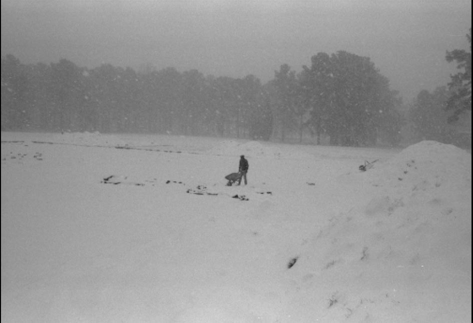 Kiln site during the blizzard of 1994.
iii
seventeenth-century Virginia, we also gained a much better grasp on the distribution of the earliest Native American occupants of Virginia, and
have come to better understand the periphery of eighteenth-century Williamsburg.
Kiln site during the blizzard of 1994.
iii
seventeenth-century Virginia, we also gained a much better grasp on the distribution of the earliest Native American occupants of Virginia, and
have come to better understand the periphery of eighteenth-century Williamsburg.
This is not a site report, which are really just reference works-places to look up the physical description of a particular post hole or fence line. Instead, this text endeavors to be a narrative that can be read from start to finish. Don't get too excited, it still contains extremely detailed descriptions of land transfers and fence lines. Information thought to be important but distracting from the main text has been separated into independent sections located sporadically throughout this volume. Those looking for even more details are welcome to visit the Department of Archaeological Research's electronic archive.
This report is arranged chronologically, from the earliest visitors to the property around ten thousand years ago to the end of the eighteenth century. The nineteenth century and, particularly, the twentieth century have stories that remain to be told elsewhere. A permanent exhibit about the history of the school is located in the lobby of the new Bruton Heights school.
I hope you will enjoy this text as much as we enjoyed searching for and excavating the Page complex.
ivAcknowledgments
Archaeology projects, particularly those that last seven years, involve an extremely large number of individuals. Without the support of each of the following people, the archaeology at Bruton Heights would not have been nearly as successful. Marley R. Brown III, Director of the Department of Archaeological Research, provided both theoretical and concrete direction throughout this project. Mark R. Wenger, Carl Lounsbury, William Graham, and Ed Chappell helped guide the architectural interpretations. Cathy Hellier conducted the preliminary historical research and is responsible for much of the Moody subdivision research. Ken Yerby, the Bruton Heights construction manager, was extremely patient as we continually disrupted his construction deadlines. Kate Meatyard explored the relationship between colonial flowerpots and formal gardens, while Dennis Blanton advised us on prehistoric matters. This volume was skillfully edited by Jane McKinney and Greg Brown. Greg, with the help of Lucinda Brackman and Tami Carsillo, also formatted this manuscript. Dave Doody and William Graham photographed the Page house. Without the support, both moral and financial, of the Bruton Heights Educational Campus project managers Steve Elliott (for the first two years) and Beatrix Rumford (for the last five years) this project would have never taken place.
Thanks also goes to the various members of the excavation team. They did a wonderful job of excavating and recording the site. Pegeen McLaughlin, Bill Pittman, Kelly Ladd, Linda Novak, and Emily Williams all helped guide the artifact-related research. Kim Wagner, Christina Adinolfi-Kiddle, David Brown, and Heather Harvey were responsible for the drafting. In addition, David Brown, Kim Wagner, Heather Harvey, and Gary Robinson rendered the illustrations. Joanne Bowen and Steven Atkins put in many hours identifying the faunal remains.
Throughout the project, the Page family took considerable interest in the excavations. In particular, Cecil Wray Page, Virginia Page Harrison, and Rocky Page provided extensive support and information about past and present members of the Page family.
Finally, we would like to thank the Bruton Heights Educational Campus construction workers who continually brought important archaeological evidence to our attention. Their interest and initiative considerably improved the quality of the archaeology at Bruton Heights.
vi| Page | |
| PREFACE | i |
| ACKNOWLEDGMENTS | v |
| LIST OF FIGURES | ix |
| LIST OF TABLES | x |
| CHAPTER 1: INTRODUCTION | 1 |
| Past Investigations | 2 |
| CHAPTER 2: BEFORE THE ENGLISH | 7 |
| Bruton Heights and the Native American Landscape | 7 |
| Evidence of Early Hunters | 7 |
| Procurement Camps | 11 |
| Site 44WB68 | 11 |
| Site 44WB70 | 13 |
| Summary | 14 |
| CHAPTER 3: "BETWEEN CIVILIZATION AND SAVAGERY": MIDDLE PLANTATION AND THE PALISADE OF 1634 | 15 |
| The Powhatan | 15 |
| Anglo-Powhatan Relations | 17 |
| "The sonnes of wrath" | 18 |
| "Winning the forrest" | 19 |
| "Posts pales and railes": The Archaeology of the Palisade | 23 |
| Summary | 28 |
| CHAPTER 4: JOHN PAGE AND THE GROWTH OF MIDDLE PLANTATION | 31 |
| Virginia at Mid-Century | 31 |
| Origins and Early Career of John Page | 31 |
| Building an Estate | 33 |
| Archaeological Clues in the Landscape | 35 |
| Brick and Tile Manufacture at Bruton Heights | 39 |
| Clay Borrow Pit | 39 |
| Clay Preparation Areas | 40 |
| Pugmills and Water Barrels | 40 |
| Irrigation Trench | 41 |
| Earthfast Structure | 42 |
| Semi-Permanent Kiln | 43 |
| Social and Economic Implications | 45 |
| viii | |
| CHAPTER 5: THE PAGE ESTATE | 53 |
| The Manor House | 53 |
| The Outbuilding | 63 |
| The Changing Landscape | 67 |
| The Page Artifacts | 71 |
| Artifacts and Status: The Ravine Assemblage | 75 |
| CHAPTER 6: THE EMERGENCE OF WILLIAMSBURG | 85 |
| Into the Eighteenth Century | 87 |
| Destruction of the Page House | 88 |
| Household Artifacts | 91 |
| Cross-Mending Results | 93 |
| The End of the Page Years | 96 |
| CHAPTER 7: THE MOODY SUBDIVISION | 99 |
| The Historical Background | 99 |
| The Archaeology of the Moody Subdivision | 100 |
| Alexander Craig's Lot | 104 |
| James Barrett Southall's Lot | 105 |
| The Trash Midden | 108 |
| Mystery Feature | 109 |
| The Depositional History | 112 |
| CHAPTER 8: EPILOGUE | 115 |
| REFERENCES CITED | 119 |
| Page | |
| 1. Bruton Heights School in relation to Williamsburg's Historic Area | 1 |
| 2. One of a thousand shovel test units | 3 |
| 3. Location of archaeological sites | 4 |
| 4. Composite plan of features around Bruton Heights School | 5 |
| 5. Dalton point | 8 |
| 6. Assorted projectile points found at Bruton Heights | 12 |
| 7. Remains of palisade of 1634 posthole and ditches | 24 |
| 8. The linear berm of the palisade is visible in this 1927 aerial photograph of Williamsburg | 25 |
| 9. Close up of the palisade remains seen in the 1927 photograph | 25 |
| 10. Plan view of a section of the palisade | 26 |
| 11. Cross-section of palisade complex | 27 |
| 12. Portrait of John Page | 32 |
| 13. John Page's home site | 36 |
| 14. Remains of fenceline from the earliest period of Page ownership | 37 |
| 15. Kiln complex | 39 |
| 16. Water barrel hole | 40 |
| 17. Cross-section of water barrel hole | 41 |
| 18. Unexcavated pugmill | 41 |
| 19. Plan view of kiln | 44 |
| 20. Cross-section of kiln fire box | 45 |
| 21. Woodcut of brickmaking | 47 |
| 22. Tiles from Bruton Heights kiln | 48 |
| 23. Artist's reconstruction of the Page house | 54 |
| 24. Excavated Page house cellar | 54 |
| 25. Window lead dated "1669" | 55 |
| 26. Carved and molded bricks | 55 |
| 27. Michel drawing | 56 |
| 28. Page's cartouche | 57 |
| 29. Plan view of Page house cellar | 60 |
| 30. Outside entrance into cellar | 61 |
| 31. Newel post and framing support holes for stairs | 61 |
| 32. Stair tower | 62 |
| 33. Summer beam supports | 62 |
| 34. Cross-section of Page cellar | 62 |
| 35. Drainage sump | 63 |
| 36. Page outbuilding | 64 |
| 37. Mapping of the kitchen/quarter | 64 |
| 38. Overview of kitchen/quarter | 65 |
| 39. Billingsley bottle | 74 |
| 40. Some of the vessels found in the Page cellar | 89 |
| 41. Bottle seals found in the Page cellar | 90 |
| x | |
| 42. Stacked wine bottles | 90 |
| 43. Assorted artifacts found in the Page cellar | 92 |
| 44. Escutcheon | 92 |
| 45. Page cellar table glass | 92 |
| 46. "Spring," by David Teniers | 94 |
| 47. Anonymous, from Manual of Elementary Education | 95 |
| 48. Flowerpots from Page cellar | 95 |
| 49. Spatial distribution of a single flowerpot | 96 |
| 50. Eighteenth-century roads associated with the Moody subdivision | 101 |
| 51. Overview of eighteenth-century landscape | 101 |
| 52. Moody subdivision period foundation adjacent to Capitol Landing Road | 102 |
| 53. Remains of brick structure dating to Moody subdivision period | 103 |
| 54. Southall fence and ditch | 106 |
| 55. Southall period ditch | 106 |
| 56. Eighteenth-century midden | 109 |
| 57. Eighteenth-century midden | 110 |
| 58. Mystery feature | 111 |
| Page | |
| 1. Vessel Breakdown by Function and Type | 73 |
| 2. Page Period Ceramic and Table Glass Vessels | 73 |
| 3. Vessels found in Cellar | 93 |
CHAPTER 1.
Introduction
In 1989, the Colonial Williamsburg Foundation acquired the Bruton Heights School (Fig. 1). For the first time since 1940, children were absent from the classrooms and halls. Out in the schoolyard workmen dismantled the playground equipment to begin the process of restoring the school to its original appearance. Occasionally, former students and teachers returned to see their school. While sad that the Bruton Heights School was no more, they were pleased to hear that the structures would be renovated as part of the Colonial Williamsburg Foundation's new educational campus. These visitors were surprised, however, to learn that the Bruton Heights School was just the most recent manifestation of an ever-changing cultural landscape. A shovelful of dirt reveals more than pupils' lost pennies, marbles, and pen caps. The archaeological resources on the property document nearly 10,000 years of human activity in the remains of temporary campsites, an early fortification, a seventeenth-century plantation, eighteenth-century property boundaries, and part of an eighteenth-century neighborhood. Painstaking historical research and archaeological analysis has resulted in the recovery of a past that has a significant place in the history of the region. So, not only do the buildings continue their educational purpose, but the land itself has much to teach us.
 Figure 1. Bruton Heights school in relation to Williamsburg's Historic Area, showing the grounds of Bruton Heights prior to the early 1990s renovation and expansion.
Environment
The Bruton Heights school campus is located in Williamsburg, Virginia, along the northeast corner of Colonial Williamsburg's Historic Area. The property consists of thirty-three largely undeveloped acres. It is bounded on the south by First Street, on the east by a residential area fronting Capitol Landing Road, and on the north by the Colonial Parkway. The school campus, which consisted at the time of acquisition of the main school building, a bus maintenance garage, and the home economics cottage, is situated on a high, level terrace. Ravines sloping gently away from the terrace to the north and west serve as seasonal tributaries for Queens Creek, located approximately one mile to the northwest. Most of the ravines have become silted in by the runoff from nearly three centuries of cultivation; a ravine which extends onto the school property in the southwestern corner of the parcel was completely filled in during the construction of the school.
The area within the immediate vicinity of the school structures is level and grassy. Plowing associated with nineteenth- and twentieth-century farming evened the grade. An aerial photograph of the property taken prior to the construction of the school shows a fallow agricultural field. Upon completion of the campus, the yard east of the main structure was graded further to produce a flat athletic field. Despite the development of the campus in 1940, much of the property remains wooded. Woodlands border the northern and western edges of the parcel. A thick stand of pine was planted along the northern property boundary after the school was built. The wooded area to the west is characterized by a mature growth of beech, live oak, yellow poplar, flowering dogwood, and holly. The undergrowth thins out within the forest due to shade from the canopy overhead. Remnants of roads throughout the western end of the parcel attest to twentieth-century logging activity.
Past Investigations
Evidence of the archaeological potential of the Bruton Heights property surfaced more than fifty years ago. In the early 1940s, Colonial Williamsburg draftsman James Knight inspected the remains of a building uncovered during the installation of a sewer line on school property. He described it as a substantial brick foundation that he believed dated to colonial times (James Knight, personal communication, 1989). Thirty years later, archaeologists with the Virginia Research Center for Archaeology identified two linear mounds (44WB4) that cut across the northern end of the property as the probable remains of the 1634 palisade (Muraca and Brudvig 1993). It had been constructed across the Peninsula to protect English settlements from Indian attack and to keep livestock from straying. The palisade became obsolete within ten years as the Indians were pushed farther towards the frontier, yet it continued to serve as a landmark in the area throughout the colonial period. Many seventeenth- and eighteenth-century deeds mention the "old Pales near Middle Plantation." The archaeological potential of the property came to the fore once again in 1983 when archaeologists working on the Second Street Extension Project identified domestic sites associated with the development of the Moody subdivision, a suburb of eighteenth- century Williamsburg.
An examination of the historical record of Bruton Heights reveals only a partial picture of the past. When it is analyzed in conjunction with the archaeological record, a more comprehensive understanding of the past can be achieved. The historical record illuminates land transfers, political evolution, family heritage, and macro-economics. Archaeological evidence pertains to material culture, dietary practices, architecture, subsistence, settlement 3 patterns, and micro-economics. Taken together, they establish the social context of the region. The archaeological and historical analysis of the thirty-three acre Bruton Heights parcel is part of a larger systematic analysis of the origins and evolution of the colonial capital of Williamsburg.
Shortly after acquiring the property in 1989, the Colonial Williamsburg Foundation initiated a comprehensive plan for an archaeological and historical investigation of the property to determine the significance of the Bruton Heights area to the cultural history of the region. Researchers using documentary and cartographic sources developed a systematic strategy for locating archaeological sites on the property. Using computer-based mapping, they prepared map overlays of the 1781 Desandrouins, 1781-82 "Frenchman's," and circa 1800 Bucktrout maps, along with a modern map drafted in 1964. Preliminary analysis also determined that, apart from the construction of the school complex in the 1940s, the property was largely unaffected by twentieth-century development. Thus encouraged about the survival of archaeological resources, archaeologists initially worked to locate sites, establish their boundaries, and determine the integrity of the preserved remains by systematically excavating more than 1000 shovel test units across the property in 1990 (Fig. 2). These revealed seven archaeological sites, including a seventeenth-century palisade, four eighteenth-century sites, and two multi-component sites with prehistoric, seventeenth-, and eighteenth-century elements (Fig. 3).
The full-scale archaeological excavations conducted between July 1992 and August 1996 focused on several areas of the campus where significant cultural resources would be impacted by the renovation of the school campus and the construction of new buildings.
Site 44WB70 is located northwest of the Bruton Heights school building. It consists of an eighteenth-century trash midden and a redeposited seventeenth-century component associated with the Page kitchen/quarter.
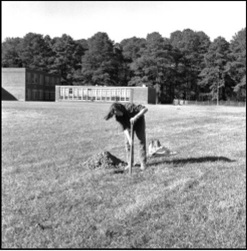 Figure 2. One of a thousand shovel test units.
Under the athletic field east of the school lay site 44WB68, the remains of a seventeenth-century brick and roofing tile manufactory. This industrial complex provided building materials for John Page's house and outbuildings and is unusual because of its medieval, rectangular, up-draft kiln design. Furthermore, the remains of the activity areas associated with the brick and tile making enterprise were extremely well preserved; they are usually difficult to identify and those that survive are often overlooked. Identified remains include post structures, brick and tile making workstations, and a large clay borrow pit that is actually located partially underneath the school.
The third site to be excavated, located west of the main school structure, was excluded during the original survey of the property due to its continued use as part of the bus maintenance facility. This site is the southern extension of an eighteenth-century artifact scatter located northwest of the
4
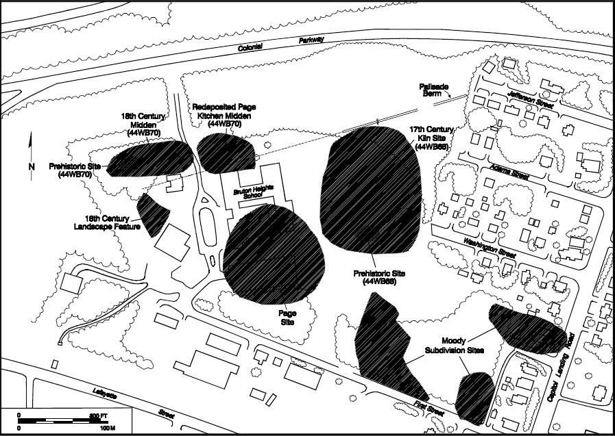 Figure 3. Location of archaeological sites.
school. The archaeological features identified in this area included two sections of the seventeenth-century palisade identified in the northeast corner of the property, a late-seventeenth-century industrial ditch, and three mid-eighteenth-century fencelines. In addition to these sites, archaeologists examined the remains of two seventeenth-century structures. John Page's house, located just south of the school, was excavated during the summer of 1995 (Fig. 4). This cross-plan brick house was built in 1662 and burned around 1730. Associated with this house was a separate brick kitchen/quarter. Partially located underneath the Bruton Heights School building, this structure provided a home to indentured Englishmen and/or enslaved African-Americans as well as a place to prepare food for the plantation.
Figure 3. Location of archaeological sites.
school. The archaeological features identified in this area included two sections of the seventeenth-century palisade identified in the northeast corner of the property, a late-seventeenth-century industrial ditch, and three mid-eighteenth-century fencelines. In addition to these sites, archaeologists examined the remains of two seventeenth-century structures. John Page's house, located just south of the school, was excavated during the summer of 1995 (Fig. 4). This cross-plan brick house was built in 1662 and burned around 1730. Associated with this house was a separate brick kitchen/quarter. Partially located underneath the Bruton Heights School building, this structure provided a home to indentured Englishmen and/or enslaved African-Americans as well as a place to prepare food for the plantation.
Prehistoric artifacts were ubiquitous throughout the project, and excavation revealed evidence of nineteenth- and twentieth-century farming activities. Yet the majority of the features identified at Bruton Heights date to the seventeenth and eighteenth centuries. The remains can be separated into three distinct periods: the early Middle Plantation period (ca. 1634-1650), the Page period (1650-1744), and the Moody/Southall period (1744-1798). The archaeological remains at Bruton Heights contribute to our understanding of regional cultural development because they address questions regarding the establishment of Middle Plantation, the relocation of the colonial capital to Middle Plantation in 1699, and the development of Williamsburg's periphery during the mid-eighteenth century. The remains of the palisade provide evidence of cultural contact and the nature of the Anglo-Powhatan frontier, as well as of the establishment of Middle Plantation. Similarly, the archaeological remains of John Page's plantation provide a glimpse into a particularly dynamic period of social transition when aspects of colonial Virginia society
5
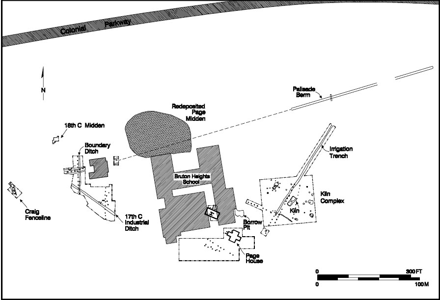 Figure 4. Composite plan of features around Bruton Heights School.
such as the plantation system, slavery, and a rigid social hierarchy were forming. The Page kiln site is evidence of the changing economic conditions in the Chesapeake during the second half of the seventeenth century and reflects the increasing standard in the quality and scale of Virginia architecture. The remains associated with the Moody subdivision reflect the dynamics of eighteenth-century population growth in Williamsburg that led to the expansion of the town.
Figure 4. Composite plan of features around Bruton Heights School.
such as the plantation system, slavery, and a rigid social hierarchy were forming. The Page kiln site is evidence of the changing economic conditions in the Chesapeake during the second half of the seventeenth century and reflects the increasing standard in the quality and scale of Virginia architecture. The remains associated with the Moody subdivision reflect the dynamics of eighteenth-century population growth in Williamsburg that led to the expansion of the town.
CHAPTER 2.
Before the English
Long before the arrival of European colonists Native Americans had modified the land. Their perceptions and the manner in which they interacted with their surroundings influenced successive views of the local landscape. The prehistoric artifacts recovered during the archaeological investigation of Bruton Heights document nearly 9,000 years of human activity on the property. Although overshadowed by the great number of historic remains, this prehistoric material provides insight into how the Bruton Heights property fits into the world of the Native American.
Preliminary excavations led to the identification of two discrete scatters of prehistoric material (see Fig. 3). The first was discovered within the limits of the kiln site and the second was found across the terrace and slope northeast of the school building. These sites are defined by the concentration of lithic material and Native American ceramics. Unfortunately, no prehistoric features were discovered in association with these artifacts, but the prehistoric remains discovered on the property are important because of their potential to contribute to a more complete understanding of the cultural history of the region.
Tidewater's Prehistory
Since native Americans first made their way into Southeastern Virginia more than 10,000 years ago, the region has undergone great climatic and environmental change. As a result, groups adapted their lifeways to meet the challenges of their environment. Traditionally, scholars have delineated periods of cultural development in prehistory on the basis of adaptive strategies (Brown et al. 1986; Moodey 1992; Muraca and Hellier 1992). According to this scheme, prehistory in this area is broken down into three broad categories which are based primarily on technological innovations reflected in the material culture (Hunter and Higgins 1986:27). The Paleo-Indian period (9500-8000 B.C.) marks the arrival of Native Americans into Virginia and their adaptation to the Ice Age conditions of the Pleistocene epoch. The Archaic (8000-1200 B.C.) period corresponds to the Holocene epoch when climatic and environmental shifts forced changes in subsistence strategies. Finally, agriculture and increased sedentism are hallmarks of the Woodland period (1200 B.C.1560 A.D.). Each of the three divisions are separated, in turn, into early, middle, and late components.
While most scholars continue to use this traditional scheme there have been efforts to introduce other methods of looking at the prehistoric past (see Hunter and Higgins 1986). Operating within the established chronological framework, new phases have been designed to reflect behavioral trends instead of adaptive strategy (Moodey 1992). This behavioral approach departs from the reliance on artifact typologies as a means of defining a chronology and considers a broader range of attributes including settlement patterns and subsistence strategies, as well as material culture. It is this new approach that will be used to trace cultural development within the region.
Phase I — Early Hunters (9500-6500 B.C.)
The first period (9500-6500 B.C.) combines the Paleo-Indian and the Early Archaic periods which saw the transition from the tundra-like conditions of the Pleistocene epoch to a warmer Holocene environment. During this time, the Ice Age ended and glaciers receded across North America. On the average, temperatures were 10 to 15 degrees cooler than they are today. Although glaciation did not reach Virginia, the area experienced climatic warming, a decrease in precipitation, and a sixty to eighty meter rise in the sea level (Gardner 1989).
The transition to a warmer environment had a major impact on the landscape. The southern Tidewater is located on an exposed portion of the continental shelf known as the Atlantic Coastal Plain. The Coastal Plain was formed 20,000 to 30,000 years ago and lay submerged throughout most of the Pleistocene. The decreased precipitation and warmer temperatures associated with the end of the Ice Age exposed this land mass, a region characterized by level terrain cut by a dendritic system of small waterways. Over time, ravines were formed by the meandering creeks and streams which flow from fresh water springs and carry storm runoff to the York and James Rivers. Near the major waterways, the ebb and flow of water at the mouths of creeks created expansive mud flats and promoted the formation of saltwater marshes.
Climatic shifts prompted change in the local habitat as well. Hardwood forests covering the area during the cooler Pleistocene gave way to oak-hemlock forests in the more temperate climate. The shift in vegetation continued so that by 6000 years ago the oak-hemlock forests were supplanted by oak and pine. Changes in the climate also caused a shift in the animal population. Megafauna such as bison, mammoth, and mastodon declined as modern animal species, including deer, turkey, geese, and turtles, began to dominate (Silver 1990:36).
Despite considerable scholarly efforts, anthropologists have only a very general understanding of the Early Hunter Phase on Virginia's Outer Coastal Plain. For example, all the Paleo-Indian artifacts that have been identified on the Peninsula are isolated projectile point finds from disturbed contexts. Consequently, archaeologists must construct predictive models based on data from modern hunter-gatherer groups and other Paleo-Indian sites in the Southeast. Early Hunter groups were nomadic due to their reliance on large game for food. Group size and movement depended on the availability and seasonality of large game and other food resources. Band-level social organization consisting of several families provided the flexibility needed to efficiently exploit resources within a region (Hunter and Higgins 1986:37). Early Hunter sites included small, short-term campsites, kill and butchering sites, and possibly base camps. These sites should probably be associated with Late Pleistocene-Early Holocene landforms in close proximity to game and a water source (Hunter and Higgins 1986:37-38).
The Paleo-Indian hunter relied upon a surprisingly simple tool kit consisting primarily of finely crafted, bifacially worked points. Experiments in stone tool replication suggest that the fluted biface was an efficient "multi-purpose" tool suited for a wide variety of tasks (Hunter and Higgins 1986:36-37). More specialized tools included scrapers, drills, and gravers. Besides the distinctive fluted bifacial forms, another hallmark of the period is the high-quality stone from which tools were fashioned. Early Hunters favored jasper and chert, which were available from select outcrops located west of the Fall Line near modern-day Richmond. Initially, the scarcity of these materials may have restricted the range of a group's movement and contributed to increased competition for resources between Early Hunters (Moodey 1992:7). In time, Indians shifted to locally available stone.
Phase II — Foragers in a New Environment (6500-2000 B.C.)
The second prehistoric period covers a period (6500 - 2000 B.C.) which is traditionally known as the Middle Archaic. During this time, the environment looked more as it does today. Warmer temperatures and increased annual precipitation combined to promote the growth of deciduous forests. This in turn created an environment conducive to the development of modern animal species. The Native American population came to rely on deer, turkeys, and ducks for food and materials. The sea level stabilized around 2000 years ago, and nearby marshes and mudflats provided Native Americans access to shellfish.
Adaptation to new environmental conditions gradually changed the lifestyle of aboriginal groups (Moodey 1992:8). This transition is reflected in a more diverse and specialized tool kit created in response to the increase in the variety of food resources. Axes and grinding stones, for example, reflect a growing reliance on plant resources. Tools were produced almost exclusively from locally available stone and reflect the growing importance of new plant and animal resources.
Much of what is known about the chronology, size, function, and settlement pattern of sites dating to this period comes from deeply stratified sites located in the Inner Coastal Plain and Piedmont regions west of the Tidewater. These camps contain evidence such as hearths and flaking stations that indicate a wide range of activities. Both base camps and procurement sites have been identified.
Procurement sites are typically associated with the exploitation of specific resources. These sites represent hunting, fishing, or gathering forays and usually consist of single artifact finds or small concentrations of worked stone. They can be found near wetlands and along the edges of streams and on terraces adjacent to interior waterways. Sites of this type would have been visited seasonally. Since many fail to yield diagnostic material, however, procurement sites from this period are often difficult to identify.
Base camps, on the other hand, were located in areas offering maximum availability of resources. Although these sites tend to be larger and more permanent than procurement sites, they too probably represent seasonal occupation (Mouer 1991:24). Base camps were usually located along interior drainages or on the edges of inland swamps. Evidence suggests, however, that the preferred location for base camps shifted from the interior upland to the river floodplains as the subsistence base changed (Klein and Klatka 1991:148-167). Many of these sites contain evidence of multiple occupations spaced over thousands of years.
Phase III — Permanent Settlement (2000 B.C.-1000 A.D.)
The transition by Native Americans from seasonal hunting and gathering to a more sedentary lifestyle began almost 4000 years ago. The changes in social systems and settlement patterns were the direct result of the shift from a forest-based economy to a focus on riverine and estuarine environments. As a result, settlements became more permanent and the population grew. This transition encompassed a series of distinct cultural episodes traditionally known as the Late Archaic (2000-1200 B.C.), the Early Woodland (1200-500 B.C.), and the Middle Woodland (500 B.C.-1000 A.D.) periods.
As in the preceding period, base camps and procurement sites are the common site types, although base camps became larger and were occupied for longer periods. The archaeological evidence also suggests that while hunting and gathering forays continued, the utilization of the interior decreased with the growing dependence on estuarine resources and, later, on agriculture (Turner 1992:114). The increased reliance on marine resources and agriculture initiated trends within the society that ultimately led to the formation of the Powhatan chiefdom.
The material culture from this transitional period offers insight into the growing complexity of aboriginal society. The increase in ground stone tools provides evidence for the growing importance of plant materials. Mortar and pestles and stone axes allowed the Native American to prepare plant remains for use. Likewise, the ability to store food became more important as the subsistence base diversified and the population became more sedentary. Ceramic technology developed in response to this need, beginning with ground steatite vessels and quickly progressing to tempered ceramic vessels. Storage pits also appeared on sites during this phase. Exchange networks advanced to such a degree that exotic, non- local materials and finished products were transported over large areas (Hunter and Higgins 1986:51).
Phase IV — Village Life and the Rise of Agriculture (1000-1560 A.D.)
The fourth prehistoric phase, traditionally termed the Late Woodland, began around 1000 A.D. By this time, Native Americans relied on a mixed subsistence strategy consisting of hunting and gathering, the domestication of corn, beans, squash, and pumpkins, and the exploitation of marine resources. Subsistence patterns varied with the seasons. Hunting, fishing, and gathering were scheduled around planting and harvesting, prompting groups to establish villages which were occupied for most of the year. The varied pattern of subsistence and a more sedentary lifestyle made it possible to support a larger population, resulting in increasingly complex social systems. This development culminated in chiefdom level societies like the Powhatan Confederacy.
Settlement patterns characterized by internally dispersed communities consisting of several villages or hamlets distributed over a large area became prevalent during this period. Increasingly a single community could include hundreds of acres (Turner and Opperman 1993:72-77). Camps were probably occupied for longer periods, although some may have still been seasonal. Housing in these communities was more substantial than it had been previously, due, in large part, to a more sedentary lifestyle. The remains of oval structures, single burials, ossuaries, and storage pits are indicative of Late Woodland sites. Palisaded villages appeared later in the period. This development is unique to the Late Woodland period and it underscores the rising socio-cultural complexity of Indian society in the Tidewater region (Turner 1992:109).
The depiction of the Chesapeake Bay on Spanish maps from the 1520s is the earliest evidence of European knowledge of the Tidewater region, although there was no significant contact until the establishment of a short-lived mission by the Spanish in the 1560s. Maps from this period provide information concerning sixteenth-century settlement patterns. English maps dating to the early seventeenth century, for example, accurately depict the distribution of Powhatan sites and, in many cases, identify sites by name (Turner and Opperman 1993). These sources reveal an organized sense of space; settlement is concentrated in the Inner Coastal Plain which offered rich agricultural land and easy access to marine resources.
Written sources provide greater detail about the Native American landscape at the time of contact. The accounts of early explorers describe cleared agricultural fields and mature forests free of underbrush (Morgan 1975). Trees were cleared from agricultural fields by stripping off rings of bark and then allowing the trees to die. Forests, on the other hand, were burned periodically to clear the underbrush to attract game and to facilitate travel between villages. Forests may have been fired as often as twice a year. This practice of clearing agricultural fields and burning the ground cover within forests resulted in large expanses of open grassland throughout the Tidewater region. John Smith observed that "Neare their habitations is little small wood or old trees on the ground by reason of their burning them for fire. So that a man may gallop a horse amongst these woods any waie, but where creekes or Rivers shall hinder" (Smith 1612, I:162, in Barbour 1986).
Bruton Heights and the Native American Landscape
Prehistoric material recovered from Bruton Heights, while not abundant, provides a glimpse of the role the property played in the local Native American landscape. Bruton Heights is located in the interior of the peninsula and was probably forested until the seventeenth century. Its location on an elevated terrace overlooking two large ravines, its good southern exposure, and its close proximity to at least two fresh water springs attracted Indians. The archaeological evidence from the site spans nearly ten millennia, suggesting that throughout the prehistoric era it offered an attractive combination of resources.
Evidence of Early Hunters
Two fragments of a biface (stone flake worked on both broad sides) provide the earliest evidence for human activity at Bruton Heights (Fig. 5). These two worked pieces of chert were discovered in a tree hole a few feet to the north of the seventeenth-century kiln. The fragments represent the point and a distal fragment, or barb, of a hafted biface. It is unusual because it was produced from Mitchell chert, a high-quality cryptocrystalline stone used by Early Hunters (McAvoy 1992:25). This chert is usually not found in this region, since its origin is located more than one hundred miles away. The quarry is situated in the Fall Zone and consists of several outcrops within a mile of the confluence of Harwood Creek and the Nottoway River in Sussex County. The chert is volcanic and typically has a "sugary" texture (McAvoy 1992:25-26). Paleo-Indian tools made of Mitchell chert do not show evidence of heat treating, a means of making the stone less brittle, which appeared several thousand years later during the Forager phase, when Native Americans began to rely on locally available stone that was easier to obtain but of lower quality (McAvoy 1992:28).
8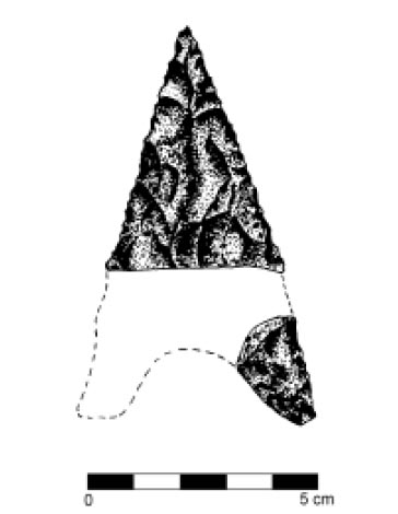 Figure 5. Dalton point.
The stylistic attributes of the tip and the barb are characteristic of Dalton-type points which were used between 8000 and 10,000 years ago (Coe 1964:67; Justice 1987:35). Dalton points range between four and nine centimeters in length and are characterized by broad, thin blades with finely serrated edges. The sides of the triangular blade are slightly excurvate, or straight, forming a sharp point. The base is concave, which gives the impression that it is a stemmed point (Hranicky 1991:22). Dalton points were produced through a combination of flaking and grinding before the serrated edge was applied through pressure flaking (Justice 1987:40). Archaeologist Joffre Coe observed that, despite a clear stylistic connection between the Hardaway-Dalton points of North Carolina and the well-crafted Dalton points of the Midwest, the "coarse grained stone available in the Piedmont was a definite factor that limited the quality of the product and handicapped the craftsman"(Coe 9 1964:64). Dalton points found in Virginia reflect the similar reduction in quality resulting from the limited availability of high-grade lithic material.
The appearance of Dalton points reflects a technological shift from the extremely widespread Clovis-dominated tool kit to a more varied tool kit that began to develop at the end of Early Hunter phase (pre-6500 B.C.), which consisted of specialized tools designed for specific purposes (Justice 1987:41). This transition mirrors change on a more basic level. Pleistocene hunters were nomadic, relying on migrating herds of bison, mammoth, and other large game. As the Ice Age ended, climatic warming resulted in drastic changes in the environment as new animal and plant species replaced those typical of a colder climate, and Native Americans too, were forced to adapt to new conditions. This transition was reflected in all aspects of culture including food procurement, site selection, and tool manufacture.
The Dalton point found at Bruton Heights appears to have been broken shortly after it was made. The straight sides, well formed point, and finely serrated edges show no evidence of reworking. Tools from the Early Hunter period were typically used over and over again for such a long period that when they were discarded they scarcely resembled the original form of the tool. Blades were reduced through progressive episodes of dulling and re-sharpening, producing "sometimes a drill-like form" (Goodyear 1974; Justice 1987:40). The reason for this extensive reuse is probably due to the scarcity of the high-quality chert out of which 10 Paleo-Indians fashioned tools. It was simpler to recycle old or broken tools than to travel far to obtain new materials.
Dalton points are rare in Virginia and virtually non-existent in the eastern part of the state, due, in large part, to the near absence of high-quality stone. While Native Americans often collected stone to be worked at a later time when the need arose, the absence of thinning or retouch flakes in association with the Dalton point indicates that it was not manufactured at Bruton Heights. Furthermore, the fragment shows evidence of a pressure break of the type which occurs through use rather than manufacture (Dennis Blanton, personal communication, 1994). The point was probably discarded when it was broken near the midsection of the point, because it could not be reshaped for further use. While it is difficult to say based on an isolated find whether a campsite was located nearby, Early Hunter remains are often associated with landforms in close proximity to game and water, conditions that were present at Bruton Heights.
Procurement Camps
In the period following the Ice Age, Native Americans established camps at Bruton Heights intermittently. It is likely that they were drawn by a fresh water spring, a good hunting spot, or some other feature as they ventured away from base camps near the waterways into the forests in search of game and other resources. Typically, light scatters of prehistoric material provide evidence for these repeated visits. Most represent hunting and gathering camps that were occupied anywhere from single night to a period of 11 several days. Two small short-term, special-purpose sites were identified at Bruton Heights.
Site 44WB68
The kiln site where the Dalton point was found also exhibited evidence of continued occupation. Prehistoric artifacts were discovered covering an area measuring approximately 197 feet by 131 feet (Muraca and Hellier 1992). The twenty-six prehistoric artifacts recovered from this site include ceramics, tools, and the stone by-products of tool manufacture and maintenance. Although the light density of the scatter suggests only occasional activity, diagnostic artifacts indicate that the area was visited repeatedly over a long period of time.
Other than the Dalton point, little evidence remains of the earliest visits. A small LeCroy projectile point (6500-6000 B.C.) provides evidence for activity dating to the increasingly temperate forager period (Fig. 6). Comparing the Dalton and LeCroy points provides an example of how changing conditions are reflected through material culture. The large size of the Dalton point and the exotic material from which it was made illustrate the efficient and multi-purpose nature of Paleo-Indian tools. The LeCroy, on the other hand, is much smaller, which suggests specialized use. The size of the LeCroy suggests it was produced to hunt smaller game. Furthermore, the material from which it was made, chert, is locally available in the form of river cobbles that erode from streambeds and the slopes of ravines.
12The majority of the diagnostic artifacts bracket the third and fourth phases of prehistoric cultural development in the region, when Native American society became increasingly sedentary. Even though Indians focused on riverine and estuarine environments, the hunting and gathering forays into the interior continued to provide meat and other resources. The diagnostic artifacts from this period include two projectile points and twelve ceramic fragments. Ten of the ceramic sherds are gravel tempered with cord-marked decoration. The fragments were identified as Popes Creek-type, dating to the period 1200-500 B.C. The two remaining pieces of ceramic were tempered with sand, display no decoration, and date between 500 B.C. and 900 A.D. One of these was recovered from a seventeenth-century posthole, while the second fragment was discovered in the fill of an historic-period pit of unknown function. A quartzite Potts projectile point (0-200 A.D.) and a quartzite Peedee point (ca. 1600 A.D.) were also recovered (see Fig. 6).
 Figure 6. Assorted projectile points found at Bruton Heights.
Two pieces of fire-cracked quartzite, six pieces of quartz debitage, and the remains of an unfinished tool provide evidence of the activities that took place in the camp (see section on Tool Manufacture). The fire-cracked rocks suggest that Indians collected stone cobbles from the ravines nearby and heated them as part of the tool-manufacturing process. The debitage may have also resulted from tool manufacture or resharpening. Two matching fragments of an unfinished tool turned up in a seventeenth-century ditch. Unfortunately, this projectile point was never fully shaped and cannot be identified as to type, nor can it be dated. It appears that the tool was broken during production and discarded. It was probably redeposited in the ditch after the kiln site was abandoned.
Site 44WB70
A second short-term procurement camp was identified along the ravine located northwest of the school. While 44WB68 produced evidence of much earlier occupation, the concentration along the ravine appears to have been the site of more intensive activity. Sixty artifacts were recovered from this site, including a utilized flake, three pieces of eroded ceramic, four flakes worked on two sides, fifty-one pieces of debitage, and five fragments of fire-cracked rock. An analysis of the diagnostic material from the site determined that the camp was the site of repeated occupations during the forager and permanent settlement periods (6500 B.C.-1000 A.D.). All of the prehistoric artifacts associated with the site were retrieved from historic-period features, however, suggesting that the features associated with 14 the prehistoric site were destroyed through plowing, landscaping, and erosion.
Two projectile points were recovered from this site. An unfinished (stage four) quartzite biface, identified as a possible Guilford (3500-2500 B.C.), may have been broken before it could be finished and used. A quartzite Halifax Side-notched point dating to roughly the same period (3500-2500 B.C.), was also recovered (see Fig. 6).
The number of diagnostic artifacts increases for the later phase of occupation. Of the three ceramic fragments recovered from the site, two were sand-tempered though too eroded for a precise identification. The remaining ceramic fragment was tempered with hematite. All three pieces date from 500 B.C. to 900 A.D. A quartzite Madison point (800-1400 A.D.) also suggests an occupation around the same time. Small triangular points of this type are found throughout the eastern United States.
An unidentifiable hafted biface and a retouched flake, both of quartzite, were the only other stone tools represented in the assemblage. Utilized flakes are large flakes removed from stone cobbles during tool production, which are then used as tools themselves. Sharpening, or retouching, provides clear evidence that the flake was used as a cutting tool.
The artifact assemblage from this site also included five pieces of fire-cracked rock, eighteen pieces of shatter, twenty-eight fragments of debitage, and eight secondary/thinning flakes. The high percentage of debitage indicates that Native Americans were drawn to this area by the availability of stone cobbles eroding from the ravine. Based on the existing evidence, it appears that the cobbles were heat treated and broken apart to provide the raw material for preforms. The absence of small tertiary (finishing) flakes suggests that the tools were not completed at this camp.
Summary
While the Bruton Heights property was never the site of a large-scale prehistoric settlement, the data indicates that Bruton Heights was visited occasionally throughout prehistory as Indians traveled through the forests on the Peninsula. The discovery of a Dalton-type biface produced from Mitchell chert suggests that Native Americans began to exploit resources located in the area during the earliest phase of Virginia's prehistory, while the discovery of a quartzite Peedee projectile point provides evidence of a Native American presence at Bruton Heights perhaps as late as 1600 A.D. All sites, however, appear to have been short-duration campsites and/or food procurement sites. Sites of this type were exploited seasonally and may represent short-term hunting and gathering forays or temporary encampments.
Tool Manufacture
Some stone fragments, known as debitage, are the by-product of tool production and maintenance. Archaeologists have identified several types of flakes and fragments which are indicative of the different phases of tool production. Stone was often heated to make it less brittle and easier to work and thus fire-cracked rock represents the initial stage of preparation. The cobble was then reduced to the desired size by removing large primary flakes. Next, the tool was shaped by removing secondary/thinning flakes. Native Americans frequently stopped at this stage and took the crudely shaped stone forms with them. These "preforms" could be fashioned into specific tools as the need arose. Once the stone implement was finished it was re-sharpened by removing small flakes of stone known as tertiary flakes.
CHAPTER 3.
"Between Civilization and Savagery":
Middle Plantation and the Palisade of 1634
The earliest historic-period occupation of the area was associated with the settlement known as Middle Plantation. To understand the importance of this settlement it is necessary to provide some background regarding conditions in eastern Virginia in the early to mid-seventeenth century. The first permanent English settlement in North America was established at Jamestown in 1607 by the Virginia Company of London. Securing this foothold brought the English into contact with an indigenous population whose culture was vastly different from their own. This pattern of English colonization had been set in Ireland beginning in the mid-sixteenth century. Despite a similar heritage and a shared religion, the English viewed the Irish as savage, while the Irish looked upon English as invaders. Relations between the two quickly deteriorated, establishing a violent pattern of rebellion and reprisal. The English approached Virginia and its indigenous population with the same "religious and cultural imperative" used to justify colonization in Ireland (Blades 1986:258). Within five years of settlement, the colonists in both lands became entrenched behind "the English Pale" (Meinig 1986, I:28).
Hostile relations with the Indians figured prominently among the factors that confined English settlement to the area along the major waterways throughout much of the first thirty years in Virginia. Without the ability to expand into the interior, the colony was vulnerable to Spanish aggression. Perhaps more importantly, the colony could not grow and prosper without the interior, which promised land for pasture and agriculture.
Middle Plantation represented the first major inland settlement for the colony. It was established by an Act of Assembly in 1632/3 to provide a link between Jamestown and Chiskiack, a settlement located across the Peninsula on the York River. This chain of settlements, it was thought would create a barrier against Indian attack by cutting off access from the north and thereby protecting the plantations located on the lower Peninsula to the south. The chain of settlements was bolstered by the construction of a palisade beginning near the mouth of College Creek, a tributary of the James, and extending eastward six miles across the Peninsula to Queens Creek, a tributary of the York. The palisade was not purely a defensive wall; instead the English used it to strengthen the position of their settlement by expanding into the interior and laying claim to land where the Powhatan Indians lived. It was an invasive strategy designed to establish a physical, frontier barrier in order to affirm English ownership of the entire peninsula.
The Powhatan
In his account of the colony's earliest days, George Percy recalled seeing Virginia for the first time. He marveled at the "faire meaddowes and goodly tall Trees, with such Fresh-waters running through the woods, as I was almost ravished at the first sight thereof" (Percy 1922:281). His description of the natives as "Savages creeping on all foure, from the Hills like Bears" reflects the attitude of most English colonists towards the indigenous population. This fear and mistrust was mixed with feelings of cultural 16 superiority over a people they believed to be "poore and miserable soules, wrapt up unto death, in almost invincible ignorance" (de la Ware et al. 1610, in Billings 1975:14).
By the time Jamestown was established, the Peninsula was occupied by an alliance of thirty-two tribes, usually called the Powhatan Confederacy, under the control of the chief Powhatan. The trade networks that stretched far across the country, brought exotic goods such as antimony, shell beads, pearls, and copper, and reflected the complexity of this confederation. Oddly enough, the European presence was felt long before widespread contact due to the transmission of European goods via the same routes. The Powhatan may even have been engaged in commerce with other European nations by the time the English arrived in the Chesapeake. In 1610, one of Powhatan's storehouses reportedly held 4000 deer skins destined for the French fur trade far to the north (Bragdon 1986:81).
The Powhatan confederacy developed primarily in the century prior to contact with Europeans (Potter 1989:154). Powhatan began to consolidate power during the second half of the sixteenth century after he inherited the territories of the lower York River, including the Pamunkey, Mattaponi, Chiskiack, Werowocomoco, Powhatan, Arrohateck, Appamatuck, and Orapaks (Bragdon 1986:78). He conquered other Virginia Algonquian tribes and made them tributary to the Powhatan. The confederacy was at its height in 1607, encompassing most of the area south of the Rappahannock to just below the James River and as far west as the Fall Line. The Chickhominy were the only Virginian Algonquian group not under Powhatan's control.
Activities within the community were organized according to season. Powhatan hunters moved upriver during the winter in search of deer and other game. Often the hunting parties were large, consisting of as many as three hundred individuals cooperating in hunting and processing (Bragdon 1986:76). Spring brought the responsibility for preparing fields, planting crops, and fishing. Summer activities typically consisted of gathering forays in the uplands for roots, nuts, and berries and along the waterways to collect shellfish. Crops were harvested in the autumn.
Organization of the landscape was greatly influenced by horticultural practices. William Strachey observed that:
Theire habitations or Townes, are for the most parte by the Rivers, or not distant from fresh Springs comonly upon the Rice of a hill, that they maie overlooke the River and take every smale thing into view which sturrs upon the same, their houses are not manie in one towne, and those that are stand dissite and scattered, without forme of a street, far and wide asunder(Strachey 1612, in Bragdon 1986:78, emphasis added).
Archaeological and ethnohistorical data suggest that villages probably consisted of kin-based household clusters scattered throughout a several-hundred acre tract (Turner and Opperman 1993:72). This strategy allowed Indian communities to farm the land efficiently by spreading the population over a larger area to increase the amount of available land for cultivation and to prevent soil exhaustion. The Powhatan practiced field rotation, including fallow intervals to restore vital nutrients, as well as swidden agriculture whereby brush fires were set to clear fields and to prepare them for cultivation. Periodic firing to clear fields and drive game lent a park-like appearance to the overall landscape. Mature trees dotted the landscape and lush grasses took the place of underbrush (Morgan 1975:54).
Anglo-Powhatan Relations
Laying claim to land in North America presented problems the English had not encountered before (Sack 1986:138). Unlike Ireland, North America was a land where the English had little knowledge of indigenous culture and little sensitivity for the native's concept of the land. Initially, the English believed they could coexist with Native Americans, sharing "the resources of a rich country," while giving them "the benefits of a better life" (Craven 1970:76). The rationale for the colonization of Virginia, written in 1610, stated that "The Principal and Maine endes" of the settlement were:
first to preach and baptize into Christian Religion, and by Propagation of the Gospell, out of the Armes of the Divell, a number of poore and miserable soules, … Secondly, to provide and build up for the publike Honour and Safety of our Gratious King and his Estates … a Bulwarke of defence in a place of advantage against a stranger enemy, … [and] Lastly, the appearance and assurance of Private commodity to the particular undertakers, by recovering and possessing to themselves a fruitfull land, whence they may furnish and provide this Kingdome, with all such necessities and defects under which we labour, and are now enforced to buy" (de la Ware et al. 1610, in Billings 1975:14-15).
Both the Powhatan and the English were accustomed to dealing with "foreigners" (Rountree 1993:173). Still, Anglo-Powhatan relations were threatened from the outset because of differing beliefs and values, including those about religion, roles within society, land, and economic goals. In the colony's first decade and a half, the English "suffered under a double dependency that precluded friendly relations with Indians, crippled local initiative in policy making, and jeopardized their very survival"(Fausz 1988:50). The London-based governing body of the Virginia Company set goals for the colony that were wholly unrealistic and often counterproductive in establishing peaceful relations with the native population. They urged colonists to move on to Indian land as well as to convert unwilling Native Americans to English religion and culture.
Land was perhaps the greatest source of friction between the two groups, specifically the differing perceptions of property ownership and land use. To the Powhatan, the land belonged to the people and the paramount chief decided who would work where (Rountree 1993:173). The population was small and the Indians grew just enough to pay their tributes and provide for themselves. Small tracts of land were used temporarily and then left to go fallow. The English had come from a much more populous country where land was seen as a valuable commodity to be bought and sold. Therefore, they did not understand Powhatan horticulture as a necessary means of ensuring the productivity of the land so much as they saw it as abandonment.
The Powhatan, on the other hand, did not understand the English practice of owning land in perpetuity, whether it was used or not (Rountree 1993:173). Because the colonizers had been granted land in Virginia by royal decree, it was difficult for them to coexist with Native Americans on land they believed they owned. This abstract form of territoriality was "in some respects being posed as a gigantic social experiment in the use of space, to affect, organize and control behavior"(Sack 1986:140) . As the colony turned increasingly towards agriculture, more and more English settlers arrived, pushing inland and forcing the Indians from land they had once farmed and hunted.
The English initially welcomed the opportunity to ally themselves with the Powhatan. Over time, however, Anglo-Indian relations degenerated into an empty 18 association based on "fear without love"(Fausz 1988:50) . Tribes living near the English settlements were the first to tire of losing their goods and their land to the English while enduring sermons on moral redemption (Rountree 1993:179). Hostilities increased as a result of the growing frustration. The Indians justified alternating episodes of trade and theft because the English were not "kin," therefore they were neither "human" nor subject to laws concerning theft (Rountree 1993:179). The English reacted to worsening relations with the Powhatan by establishing friendly relations with outlying tribes, some of which were enemies of the Powhatan (Craven 1970:81).
"The sonnes of wrath"
The First Anglo-Powhatan War erupted shortly after Lord de la Ware became Governor of the colony in 1610. Over time, the English had become more brazen in their efforts to push the Indians from their land. After the arrival of the new governor, they became even more aggressive. The English looked for any excuse to raid communities and force the Powhatan from their villages. The breaking point came for the Powhatan when English forces raided the village of Pasbehegh and "committed the double atrocity (by Powhatan standards) of killing chiefly persons who were also women and children"(Rountree 1993:183) . Powhatan responded by accusing the English of "comming hither … not for trade, but to invade [his] people, and possesse [his] Country" (Fausz 1988:51) . The Indians retaliated with repeated small-scale raids. The war concluded in 1613 with the English claiming victory. Anglo-Powhatan relations remained tense as the English continued to encroach on Indian land.
Over the next few years, the colonists "maintained their ethnocentric insularity and concentrated on the profitable tobacco fields"(Fausz 1988:51 ). The Powhatan Confederation, however, was in the midst of change. By 1613, Powhatan was an old man and his ability to rule the chiefdom had been compromised.
His brother, Opechancanough, took control and established "commaund over all the people" by 1614, although he did not actually become the paramount chief until the 1620s. He conceded defeat to the English and expressed his desire to re-establish lucrative trade relations, while at the same time he worked to consolidate tribal alliances in a force opposed to the English (Rountree 1993:192-193). This process took years of patient and careful negotiation. Opechancanough convincingly demonstrated his friendship towards the English, which lulled them into complacency. He acknowledged the superiority of Christianity and even went so far as to agree with the English that Powhatan parents should give their children to English families where they could be educated in the European manner (Rountree 1993:185-187).
Meanwhile, the English continued the behavior that had initially incited Powhatan wrath. Colonists began to cultivate tobacco in 1614 and their success attracted thousands of hopeful immigrants. The headright system, which promised fifty acres of land for each person whose passage to Virginia was paid, developed in order to facilitate the growing number of immigrants. The newly-arrived colonists expanded English settlement up and down the James River as far north as the Fall Line. By 1622, they had taken over nearly half of the core area of the Powhatan paramount chiefdom (Rountree 1993:184).
In 1618, the Virginia Company of London decided that the colonial government in Virginia was not taking the proper measures to make money or anglicize the 19 Indians. Sir Francis Wyatt was named governor and sent with a group of sympathetic councilors to remedy the situation. By appointing men of wealth and status to administer the colony, the company hoped to "promote the kind of social and political stability that the colony had not known since the regime of Governor Lord De la War"(Fausz 1988:52) .
Opechancanough issued the call for the Indian tribes between the James and York Rivers to strike against the English on March 22, 1622. This uprising devastated the colony and reduced the population by a quarter in one swift blow. Another twenty-five percent died in the following year from continued hostilities, famine from the abandonment of farm fields, and sickness (Rountree 1993:190).
A consequence of the uprising was the Second Anglo-Powhatan War, which was more costly and lasted longer than the previous conflict. The Indians waged a guerrilla campaign of small-scale raids against homesites and larger settlements scattered across the frontier. The war reached its climax in 1624 at the Battle of Pumunkey where English forces soundly defeated the Powhatan (Rountree 1993:190). Opechancanough had hoped that the initial uprising would reinvigorate the Powhatan Confederacy and re-establish its supremacy. His failure to destroy the entire colony, however, "actually strengthened the English foothold in the Bay by encouraging the most aggressive and adaptive of the local leaders to seize power and seek revenge free of Company interference"(Fausz 1988:52). The burden of recovery fell to Wyatt and the surviving members of his council. Wyatt and George Sandys were Oxford-educated men, while Sir George Yeardley and Francis West contributed military expertise (Fausz 1988:53). Together the governor and his council assumed total control of the government and organized the frightened settlers into an effective fighting force (Fausz 1988:54).
Wyatt's men ignored the call from London for genocide because it was impractical and costly. Instead, they employed the same guerrilla tactics the Indians had used against the settlers. The colonists took Indian maize and destroyed the remaining crops, while conducting extensive small-scale raids against villages. Wyatt wisely urged colonists to concentrate on raising tobacco. Record tobacco harvests were produced during the 1620s "with captured Powhatan maize keeping them alive, and fear of Powhatan attacks keeping them in line"(Fausz 1988:55). Wyatt and his council were criticized in England for their independent action. One of Wyatt's lieutenants responded to the charges, saying:
[Although] itt is much to be desired, that either good men were commaunders or els that commaunders were good men … we are all by nature the sonnes of wrath: servinge … the spirrit that rules in the hartes of the disobedient(Fausz 1988:56).
Despite the uproar over Governor Wyatt's method of mobilizing the colony, its effectiveness was beyond dispute. Peace was finally reached in 1632 when the Jamestown government negotiated separate treaties with the Chickahominy and the Pamunkey.
"Winning the forrest"
The second Virginia Company charter, issued in 1609, signaled a shift in the colony's agenda from exploration, exploitation and religious conversion to self-sufficiency and production for the home market (Rountree 1993:180). The new plan presented the Jamestown government with the dilemma of encouraging settlement of the interior while at the same time protecting colonists from the growing threat of hostilities with 20 the Indians. The colonists met both challenges by fortifying their settlements.
Early English fortification in Virginia was purely defensive and based on medieval models. Settlements were enclosed within protective palisades and, often, land within the immediate vicinity of the settlement was surrounded by a second wall to provide a secure area for crops and grazing in times of crisis. The role of fortification in Virginia changed over time, however. The realization of tobacco's economic viability in 1614 had attracted record numbers of immigrants and created an insatiable demand for arable land. After the 1622 Indian uprising, colonists revived an earlier plan to build a fortified settlement inland on the James-York peninsula. Instead of establishing a presence in the traditional sense with fortified outposts, the new plan proposed expelling the Indians from the peninsula and sealing its northern end with a palisade. While the ability to effectively patrol and maintain such a large fortification might be called into question, there is no doubt that it would send a powerful symbolic message that the Peninsula was English land and that the Indians were not welcome. After years of failed plans and false starts, Middle Plantation was established by an Act of Assembly in 1632. This cleared the way for the construction of a palisade that upon its completion in 1634 stretched six miles across the peninsula.
Landscapes dotted with castles and medieval walled cities were familiar to the English. As England expanded beyond its borders to establish colonies beginning in the sixteenth century, the defensive wall was adapted to serve the needs of a particular region. In Ireland, for example, walls were constructed around towns while landlords were required to enclose manor houses within smaller protective palisades known as "bawns" (Blades 1986:258). In many respects, the experience gained in Ireland guided the efforts to settle Virginia. The first Englishmen to arrive at Jamestown in 1607 wasted little time in constructing a fort to protect themselves from the unknown (Noìl Hume 1982:27). William Strachey described the town in 1610 as being enclosed "with a Pallizado of Planckes and trongposts, foure feet deepe in the ground, of young oaks"(Purchas 1753, in Noìl Hume 1982:150) .
The settlers took great care to situate early settlements in areas that were difficult to attack and easy to defend. Henrico was established in 1612 as an outpost upriver from Jamestown to broaden the base of settlement, which would make the colony less susceptible to Spanish attack. Captain John Smith reported that the "Towne is situated upon a necke of plaine rising land, three parts invironed with the maine River, the necke of land well impaled, makes it like and Ile"(Hamor, in Muraca and Hellier 1992:30-31). Its isolated and exposed location inland near the Fall Line underscored the need to build the settlement within a protective enclosure. Ralph Hamor wrote that Henrico was protected by "pales posts and railes" complete with watch towers, a storehouse, and a church" (Hamor, in Muraca and Hellier 1992:38). A second palisade constructed across the neck of land nearly two miles from town created another obstacle against attack and provided a safe area to tend crops and graze cattle. Captain Smith described this palisade as being "neere two miles in length from River to River, guarded with several commanders, with good quantity of Corneground impailed, sufficiently secure to maintain more than I supose will come this three years" (Hamor, in Muraca and Hellier 1952:30-31). Henrico, therefore, was designed to be a fortress which could remain self sufficient even under siege from the Indians or the Spanish.
Deputy Governor Sir Thomas Dale ordered the construction of palisades in other 21 exposed areas. In 1613, he established the settlement of Bermuda Hundred on the cleared site of an Appamattuk Village fronting the James River (Muraca and Hellier 1992:38). A two-mile long palisade was constructed across a neck of land, creating a bottleneck that restricted access to the settlement. Ralph Hamor wrote that this enclosure provided "some eight miles circuit of good ground, for the most part champion, and exceeding good Corne ground"(Hamor 1957, in Muraca and Hellier 1992:38). As an added measure of protection, houses were built every half mile along the line to guard and maintain the wall. A palisade seven and a half feet tall surrounded four hundred acres of Bermuda Hundred (Noìl Hume 1982:220). Likewise, Rochedale Hundred was secured with "a crosse pale welnigh foure miles long … also planted with houses along the pale, in which our Hogs and cattlell have twentie miles circuit to graze in securely"(Hamor 1957:30-31) .
Although settlement continued to spread, it was largely confined to the banks of the major waterways. Access to the water provided greater security and made travel easier, yet Virginia's leaders understood that the farm and pasture land needed to support a growing colony lay inland. Sir Thomas Dale first communicated this concern in a letter to the Earl of Salisbury dated 1611. He argued that a fortified settlement on the York River at Chiskiak would allow the English to control the interior of the Peninsula. He also contended that such a move would be an outward sign of English superiority over the Indians (Muraca and Hellier 1992:38). Dale's arguments must not have swayed his superiors for no further action was taken at that time.
In the wake of the uprising of March 22, 1622, colonists embraced the idea of securing control of the Peninsula by establishing a string of settlements stretching from Chiskiack to Jamestown (Muraca and Hellier 1992:39). The Governor, Sir Francis Wyatt, described the plan in 1626 when he informed the Virginia Company of his intention to "expell the Salvages to gaine the free range of our country for the encrease of cattle, swine &c which will more than restore us" by settling "the whole Colony (or most part thereof) upon the Forrest," which would be protected by a "strong Palisado from Martins Hundred to Cheskiacque"(Wyatt 1626, in Muraca and Hellier 1992:39). Subsequently, William Claiborne of Kecoughtan and Samuel Mathews of Denbigh offered to construct the palisade across the Peninsula, prompting Wyatt to write the Privy Council in London:
We have by experience since the massacre as wee alsoe did then forsee and advertize, that being seated in the course we are in smale bodies, neither is it possible to prevent the suddaine incursions of the Salvages, nor secure any secure range for cattle … we know of no other course, then to secure the forrest by running a pallizade from Marttin's hundred to Kiskyack, which is not above six miles over, and plaecing houses at a convenient distance, with sufficient guard of men to secure the necke whereby wee shall gaine free from possibility of annoyance by the Salvages, a rich ceramite of ground contayneing little less than 300,000 acres of land, which will feed nombers of people, with plentifull range for cattle as may bee able to defend the plantation against any enimy whatsoever(Wyatt 1626, in Patrick 1983:8).
The prospect of enclosing 300,000 acres of land was no longer purely defensive in scope. Instead, the plan reflected an "expansionist mentality" that had not been evident on this scale before in Virginia (Muraca and Hellier 1992:39). Support for Wyatt's plan faded, however, as the Second Anglo-Powhatan War continued.
In 1630, Governor John Harvey proposed to secure the area between Archers Hope 22 Creek (now College Creek) on the James River and Queens Creek on the York River. He argued that the plan to "plant Chiskiake scituat upon the Pamunkey river very strongly, and to run a pale thence to Martin's Hundred" would "add safety, strength, plenty, and increase of cattle to the plantation and greate advantage from that place to assaile the enemy in his chiefest strength" (Harvey 1630, in Muraca and Hellier 1992:40). Harvey called a convention to discuss the matter in October 1629. He reported the results of this meeting in a letter to Lord Dorchester, dated 29 May 1630:
It was alsoe concluded to proceede in the warr with the Natives, either to roote them out, or force them to seek peace, to wch end we alsoe agreed the next spring to plant Cheskeyack, a place Scituate upon the Pomondkey, being a river next to us northward, whereby we shall face our greatest enemie Appochankeno [Opechancanough], and disable the Salvages to annoy us, or hinder the free range of our cattell in the forest(Harvey 1630,in Muraca and Hellier 1992:39).
Governor Harvey met with his council on October 8, 1630 to lay out the palisade. They decided to entice settlers into the interior "for securing and taking in a tract of land called the forrest" by offering fifty acres the first year and twenty-five the second year (Muraca and Hellier 1992:40). Land grants were issued as a means of attracting settlers inland and securing the line of settlement across the Peninsula. An act passed on October 8, 1630, "for the securing and taking in a tract of land called the forrest," provided fifty acres to anyone willing to settle at Chiskiack, with the understanding that the holding would be doubled when the land was actually occupied (Hunter et al. 1983:59). The Assembly initiated the process of settling Chiskiack by giving the regional commanders, Captain John West and Captain John Utie, six hundred acres of land each (Muraca and Hellier 1992:40). The establishment of Chiskiack made it possible to secure a strong line of defense between the York and James Rivers.
Efforts to link the York and James River communities with an interior settlement in the middle of the Peninsula began two years later. On June 6, 1632, Dr. John Pott acquired the patents to twelve hundred acres near the head of Archers Hope Creek. There is little doubt that Pott hoped to profit from speculating on this land, for he was an ambitious man who was often accused of promoting his own self interest "by foule and covetous ways"(Morgan 1975:122). In September of the same year, the General Assembly voted to expand the land grant offer of fifty acres to include the entire area between Archers Hope Creek and Queens Creek. The plan to erect a palisade was finally passed into law by the Assembly on February 8, 1633. The "Act for the Seatinge of Middle Plantation" formally established the first interior community and provided for its protection.
Work on the palisade finally began in February 1633/4 when one out of every forty men between Archers Hope and Queens Creek was ordered to report to the house of Dr. John Pott at Middle Plantation on March 1st to begin construction. The palisade must have been raised within a year, for in recounting his travels through Delaware and Virginia in 1634, Captain Thomas Yong reported that Governor Harvey:
hath caused a strong palisade to be builded upon a streight between both rivers and caused to be built in several places upon the same, and hath placed a suffiecient force of men for defence of the same, whereby all of the lower part of Virginia have a range for their cattle, near fortie miles in length and in most places twelve miles broade. The palisado is very neare six miles long, bounded in by large Creekes. He hath an intention in this manner to take also in all grounde between those two Rivers, and 23 so utterly excluded the Indians from thense(Yong 1871, in Muraca and Hellier 1992:41).
The palisade of 1634 probably served its purpose well because there is no other mention of the palisade across the Peninsula until after 1644 when Opechancanough launched a surprise mass attack on English settlements just as he had on March 22, 1622. Even then, the threat of war must not have seemed too great because officials had problems getting men to help rebuild the palisade. Captain Robert Higginson, the commander of Middle Plantation, was forced to seek help from the York County Court to remedy the situation (Muraca and Hellier 1992:41).
"Posts pales and railes":
The Archaeology of the Palisade
The palisade of 1634 played a crucial role in redefining the cultural landscape of the Peninsula. The English and the Powhatan had different views of the landscape. The English believed that constructing a physical barrier across the Peninsula gave them control of the countryside it enclosed. The palisade served as a tangible symbol delimiting the frontier.
The term palisade was coined in 1596 to describe a fortified wall constructed of large timbers with sharpened ends; its function was to repel attack and protect those within its walls. One hundred years later, the term appears to have taken on a variety of meanings. Noìl Hume rightly points out that it could mean anything "from a massive fortification of vertical planks (like the walls of Jamestown) or split trees, to an elaborately ornamental fence" (Noìl Hume 1982:70). Two types of palisade construction seem to have been used in Virginia during the seventeenth century: a type constructed of posts set closely together in a trench and the "more sophisticated paled, post and rail variety" (Patrick 1983:10). The type of palisade constructed probably depended upon what was to be enclosed.
Peter Nicholson's Encyclopedia of Architecture from the 1850s describes the trench-set palisade as:
an enclosure of stakes or piles driven into the ground, each six or seven inches square, and nine or ten feet long: three of which are hid underground. They are fixed about six inches asunder, and braced together by pieces nailed across them near the tops, and secured by thick posts at the distance of every four or five yards(Nicholson, in Patrick 1983:9).
Clearly, the scale of constructing a palisade for protection would have been much greater, yet the concept was the same. The trench-set palisade appears to have been used to enclose fortified house sites and other small settlements. For example, Clifts Plantation was enclosed with a trench-set palisade in 1675 for protection against raids by the Susquehannock Indians (Neiman 1978). In his survey of private fortifications during the seventeenth century, Charles Hodges identifies six examples of trench-set stockades, including Yeardley's redoubt (44PG64), the Yeardley/Piercey tobacco bawn at Flowerdew Hundred (44PG65), and the Harbor View tobacco bawn (44SK192) (Hodges 1993).
The post, pale and rail wall, on the other hand, appears to have been used to secure larger settlements and frontier boundaries. William Strachey wrote that the Jamestown fort was built "with a Pallizado of Planckes and strong Posts, foure foote deepe in the ground, of yong Oaks. Walnuts, &c."(Strachey, in Noìl Hume 1982:150-151). Likewise, Ralph Hamor described the stockade protecting the peninsula where the Henrico settlement was established as "pales, posts and railes" (Hamor 1957, in Muraca and Hellier 1992:38). Walls of this 24 type have been identified archaeologically at Wostenholme Towne. This community, settled in 1620, was protected by a stockade of large, tall posts set at nine-foot intervals. Some of the defenses at Flowerdew Hundred also fit this description (Muraca and Hellier 1992:45). Such defenses would have been constructed by placing large posts in the holes and connecting them with horizontal rails or stretchers that were pegged, nailed or mortised into the posts. Pales were then nailed or pegged to the rails (Patrick 1983:9; Muraca and Hellier 1992:43).
Several clues suggest that the palisade of 1634 ran across the Bruton Heights parcel (Fig. 7). First, John Page's 1683 patent for the parcel of land that included the school property lists "the old trench where the pales stood" as part of the boundary (York County Records, Deeds, Orders, and Wills 1:159-160). Thomas Penman's deed for the same parcel of land, dated 1747, lists "ye End of a Ditch" as a boundary (York County Records, Deeds and Bonds 5:219-224). The measurements given in the 1747 deed match those of the 1683 patent, suggesting that this was the same ditch. Moreover, aerial photographs taken of the property in 1927 show a linear berm running across the northern end of the property on an east/west axis in the area described by the earlier documents (Figs. 8 and 9).
 Figure 7. Remains of palisade of 1634 posthole and ditches.
A berm resembling that depicted in the photograph still exists on the Bruton Heights property. The linear feature is oriented 100° west of north and extends nearly 2500 feet across the northern end of the school property. By 1978, the berm was identified as the possible remains of the 1634 palisade. A trench excavated across the feature in 1990 revealed features reminiscent of the post pale and rail method of palisade construction, but no diagnostic artifacts were recovered from any of the features associated with this earthwork to indicate its period of construction.
A test unit measuring approximately 15' by 3' was excavated across a well-preserved section of the berm (Fig. 10). This cut exposed a large, structural posthole on the center of
25
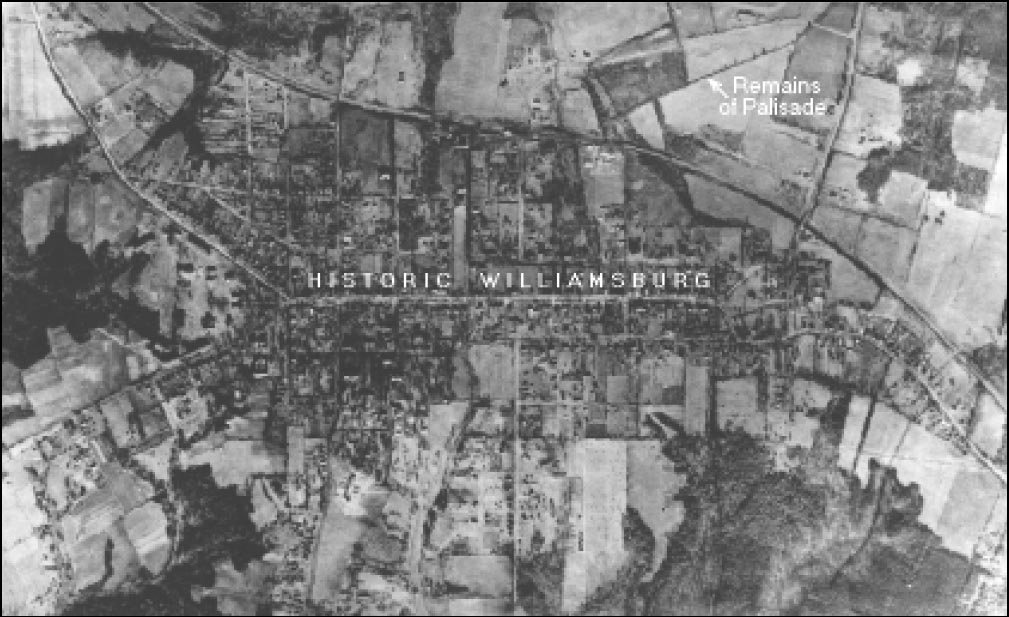 Figure 8. The linear berm of the palisade is visible in this 1927 aerial photograph of Williamsburg.
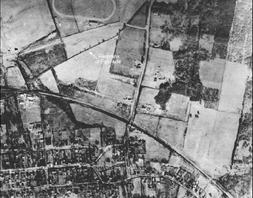 Figure 9. Close-up of the palisade remains seen in the 1927 photograph.
26
Figure 9. Close-up of the palisade remains seen in the 1927 photograph.
26
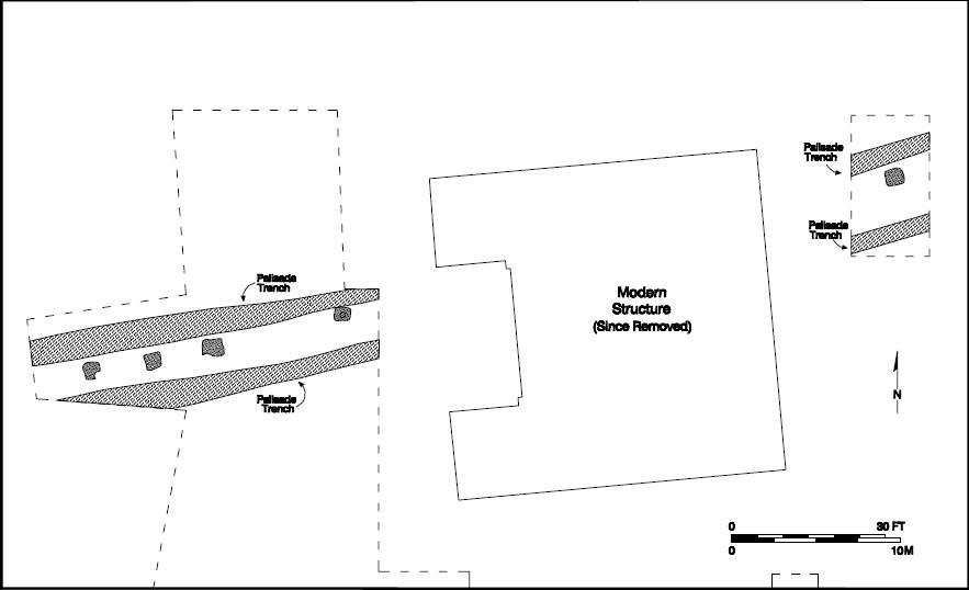 Figure 10. Plan view of a section of the palisade.
the berm bracketed by two parallel trenches. Both trenches measured 2 feet across and were located 4 feet apart. The northern trench was deeper, averaging 1'4" deep while the southern trench was 7" deep. Both trenches included three layers of sandy silt, which suggested that the trenches were left open and eventually silted in.
Figure 10. Plan view of a section of the palisade.
the berm bracketed by two parallel trenches. Both trenches measured 2 feet across and were located 4 feet apart. The northern trench was deeper, averaging 1'4" deep while the southern trench was 7" deep. Both trenches included three layers of sandy silt, which suggested that the trenches were left open and eventually silted in.
The berm situated between the two trenches measured almost 3 feet wide and consisted of three different layers of soil. The upper most layer was 6 inches thick and consisted of a tan, redeposited sandy silt subsoil. This sealed 8" of gray brown loam. These strata in turn sealed a half-inch gray loam layer that overlaid subsoil, through which a posthole had been dug. The location of this layer in relation to subsoil indicates that it was the first and earliest stratigraphic formation above subsoil. The hole that intrudes it, as well as the berm that seals it, are also early stratigraphic events (Muraca and Hellier 1992:44).
The posthole first became visible when the uppermost two layers of the berm were excavated and removed. Rodent and root disturbance appears to have obscured any trace of the posthole in the upper portion of the berm. No mold was detected and no artifacts were recovered from the dark yellow redeposited subsoil fill of the hole.
It is evident from the archaeological evidence that the postholes were dug first. Although only one posthole was identified, historical sources indicate that military fortifications like the palisade probably used an interval of 8 to 12 feet between postholes (Patrick 1983:8-9). The builders placed large posts in the holes and back-filled them. Horizontal rails were attached to the posts, and pales were nailed or pegged to the rails. Soil was packed from the large northern trench against the front of the wall and the soil from the southern trench behind the wall (Muraca and Hellier 1992:43).
Further work, conducted in 1994, exposed 58 feet of this boundary feature in two sections that bracketed the home economics cottage built in 1940 (Fig. 11). The most recent area of investigation is located 100 feet
27
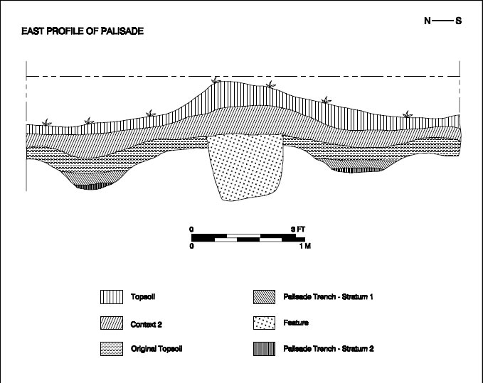 Figure 11. Cross-section of palisade complex.
west of the 1990 test trench. The newly exposed sections extend along the same orientation as the extant berm located in the northeast corner of the school property. Despite the reduction of the raised berm to grade level through plowing and landscaping activities, the features are well preserved.
Figure 11. Cross-section of palisade complex.
west of the 1990 test trench. The newly exposed sections extend along the same orientation as the extant berm located in the northeast corner of the school property. Despite the reduction of the raised berm to grade level through plowing and landscaping activities, the features are well preserved.
The 10 foot section uncovered in front of the brick cottage reflects the same configuration of features noted during the earlier excavation of the extant berm. Excavation revealed the dark stains of two parallel ditches, each averaging 32 inches wide and 7 inches deep. The remains of the berm between the ditches had been reduced to grade level and measured 9 feet wide.
Three postholes were also exposed in the center of the berm. The largest one measured 2'6" by 2' and extended to a depth of 1'8". It was cut by another posthole, this one containing artifacts deposited after 1720. The dark loamy fill removed from the postmold was devoid of artifacts. Excavation revealed that the profile of the postmold was somewhat bell-shaped, which suggests that the original post had been removed by rocking it back and forth to loosen it from the surrounding soil. Orange clay fill around the original post was the last layer in the hole to be removed. This soil did not contain any artifacts, which indicates that the posthole may date to the first half of the seventeenth century. The third posthole was a small circular hole measuring 10 inches in diameter. The hole contained evidence of a dark brown, organic postmold that marked the position of the decayed post. The postmold was ringed by yellowish orange clay subsoil on the outside. The small diameter and the even cylindrical sides of the posthole suggest it was dug with an auger, a method that originated in the nineteenth century. This is the remains of a late nineteenth- /early twentieth-century fenceline.
The ditch and berm complex in front of the cottage dipped slightly to the east, clipping the head of a ravine that had become silted in from three hundred years of agricultural run-off. This ravine, which extends northwest and forms an arm of the Governors 28 Spring Branch feeding Queens Creek to the north, was clearly not avoided when the ditch and berm were constructed. Rather, the relationship between the palisade and the surrounding topography indicates that it was built with little regard to the landscape. The palisade cut straight across the terrace instead of incorporating depressions and ravines into its design in order to increase its effectiveness.
The section of trench exposed behind the brick cottage extends nearly 50 feet to the west of the building. This segment not only revealed the same configuration of features as seen elsewhere on the property, it also contained three postholes set at 15 foot intervals. Interpolating for the area behind the cottage, it appears that four posts lie buried under the cottage between the eastern and western sections of the exposed palisade. The posts averaged 2'6" by 2' by 1'6". The westernmost two postholes had been disturbed by rodents and intruding roots, and each of the holes had been cut by a post belonging to a post and rail fence that appears to have been constructed along the center berm during the mid-eighteenth century. The yellowish orange clay in the bottom of the holes contained no artifacts. This was similar to the fill removed from the posthole in front of the cottage as well as to the one exposed in the trench excavated across the berm in the northeast corner of the property.
The berm and its associated ditches combine to form a boundary feature measuring approximately 9 feet wide. The inside trench averaged 3 feet wide and approximately 1 foot deep while the northern trench was 3'11" across and averaged 1'5" deep. Three silty layers were detected in the trenches, suggesting that they had silted in over time.
Nearly two hundred artifacts were recovered from the north and south ditches of the palisade feature. The material discovered in the ditches dated to the eighteenth century; the mean ceramic date, computed from the artifacts using Stanley South's formula, is 1740 (South 1977). The mean date of 1739 computed for the northern ditch is so close to the date of 1742 calculated for the southern ditch that it is reasonable to assume that they were open during the same period. The enigmatic result is that while the berm dates to the seventeenth century, its ditches remained open until the mid-eighteenth century.
The stratigraphy of the berm in the northeast corner of the property indicates that the earth used to create it came from the trenches and was piled in the area between the ditches (Muraca and Hellier 1992:43). Helping to preserve the berm was its later use as a property boundary. Several generations of fencelines discovered on the berm indicate that this was the case. The earlier holes are free of artifacts which suggests that they pre-date the Page site. Artifact concentrations increase in later holes. Moreover, aerial photographs show a fence existed on the berm as late as the 1920s.
Well into the nineteenth century, it was a common practice for property owners to dredge the ditches along a fenceline. Ditches surrounding fields, pastures, and orchards had to be cleaned out periodically to maintain the effectiveness of the boundary. The ditches not only served as a means to enclose crops and livestock, but also helped to drain water away from the fence where it could rot the wooden posts. In 1770, prominent Virginia landowner Landon Carter wrote in his diary:
My ditchers have been a full week scowring my ditch round the London orchard which has a double ditch and a fence upon it(Carter 1770, I:530).
Dredging ditches was clearly a necessary but time consuming task. The archaeological evidence suggests that a post and rail 29 fence, with posts on 7 foot centers, was constructed down the center of the berm some time after 1720. The posts to this fence intruded all but the easternmost palisade holes.
Summary
The archaeological evidence discovered at Bruton Heights presents a compelling argument for the palisade of 1634. The combined phases of testing have identified a ditch and berm complex that extends nearly a quarter mile across the northern end of the Bruton Heights School property. Like the feature depicted in the Kemp map of 1642, the Bruton Heights palisade runs straight across the landscape instead of following the topography. Excavation also revealed evidence of the post, pale and rail construction technique described for the Jamestown fortification and at the frontier settlements of Henrico and Bermuda Hundred. Although this form of military construction has been described as "sophisticated" for the period, one would expect it to be used on something as important as a trans-peninsular wall, which was designed both to keep the livestock in and the Indians out (Patrick 1983:9). The size of the features found at Bruton Heights also suggest that the scale of the wall constructed across the Bruton Heights property was impressive. Postholes spaced at 15 foot intervals measure 2'6" on a side and extend 1'5" into the ground. This, combined with two ditches measuring 1'6" deep, would have posed a formidable obstacle to anyone trying to cross into English territory on the Peninsula.
The wall constructed across Bruton Heights would have fulfilled the function Thomas Dale, Francis Wyatt, and John Harvey had intended. By creating a formidable barrier, the Bruton Heights palisade would have become "a functionally effective 30 'symbolic' barrier"(Samson 1992:29) . The importance of the palisade was not its ability to prevent Indians from entering so much as it was a signal that they were crossing into English territory. According to Samson:
to struggle up a bank, jump over a ditch, climb over a wall, crawl under a fence, or crash through a hedge all involve the individual in unambiguous actions which remove the possibility of unintentional entry (1992:29).
Over time, the function of the palisade in Virginia shifted from a protective enclosure designed to protect a fledgling colony to a means of taking control of the countryside so that the colony could expand. The palisade of 1634 must have served its purpose well. During the 1644 uprising, settlement had expanded to such a point that a new palisade had to be constructed. The palisade of 1634 slipped from public consciousness after the frontier moved north and west. Land transactions citing this prominent landmark feature bear witness to its decay. The use of the berm as a convenient location for fencelines by successive generations shows that it continued to be a presence in the landscape even if its metaphoric significance faded as Virginia filled with Englishmen seeking farms.
Other Palisade Trenches?
Several archaeologists have identified portions of what they suspected to be the 1634 palisade. The most compelling of these sites was identified in 1990, approximately one mile north of the Bruton Heights property. Archaeological testing in this area by Espey-Huston and Associates, Inc. under the direction of Alain Outlaw revealed a 28' segment of a narrow, linear trench running northeast to southwest. The trench was nearly 1'6" wide and contained a number of circular stains representing the remains of rotted posts. The posts, which varied from a half to one foot in diameter, were placed side-by-side in the trench and yellowish-orange clay was backfilled around the posts. Excavation of the trench revealed that it survived to a depth of 2' beneath the plowzone and consisted of vertical sides and a flat bottom. No artifacts were recovered from the feature (Outlaw et al. 1991).
While trench-set palisades were frequently constructed during the seventeenth century, most appear to have been built as private enclosures. Evidence of fortified home sites employing this form of palisade construction have been identified at Chiskiack Watch in York County, Harbor View in Suffolk, Clifts Plantation in Westmoreland County, and Flowerdew Hundred in Prince George County (Muraca and Hellier 1992; Neiman 1978; Hodges 1994). Furthermore, a test trench excavated to intersect the feature one hundred feet to the northeast failed to locate the trench (Muraca and Hellier 1992:48). While this could mean that the trench-set palisade followed the topography, it could just as easily mean that the trench represented a smaller enclosure for a house or a group of structures. The strongest evidence that the trench-set feature found by Outlaw is not the remains of the 1634 palisade comes from the 1642 sketch of Richard Kemp's landholdings showing the palisade extending in a straight line across the landscape without regard to the surrounding topography (Muraca and Hellier 1992:48).
CHAPTER 4.
John Page and the Growth of Middle Plantation
The twenty or so years that followed the construction of the palisade were quiet ones at Bruton Heights. It was not until the 1650s, when John Page moved to York County, that intensive activity on the site began again. Upon his arrival, Page entered into a period of building that ultimately led to a house and outbuildings that were in many ways unique components of Virginia's landscape. Page's brick manor house was constructed in an architectural style that was consistent with his high status in the colony. Moreover, the brick that formed the walls and the tiles that capped the structure conveyed Page's importance in Virginia. At a time when most Virginians constructed crude, post in the ground structures, Page built a house that reflected his wealthy, English heritage. The tile kiln discovered at Bruton Heights provides clues about a seventeenth-century industry; it also hints at the aspirations of one of Virginia's most prominent seventeenth-century inhabitants and about the evolution of Virginia society in the second half of the seventeenth century.
Virginia at Mid-Century
To fully appreciate Page's creation, it is necessary to put it in historical context. The character of the Virginia colony began to change by the mid-seventeenth century. The Third Anglo-Powhatan War (1644-1646) signaled the end of the Indian threat for Middle Plantation and the lower Peninsula by effectively pushing the frontier back to the Fall Line near Richmond. The expanse of land which had been coveted for so long was now waiting to be settled and planted. By this time, the colony had fully embraced tobacco monoculture and Governor Berkeley worked to develop commerce by inviting the Dutch to trade finished goods for tobacco. A second generation of colonists eager to profit from tobacco began to arrive during the 1630s and 1640s. While the first generation of settlers had cleared the land and had pioneered a tobacco-based economy, the second generation was quick to learn from their mistakes and improve upon the situation (Middleton 1992:43). The immigrants who arrived at mid-century differed from their counterparts who had come ten or fifteen years earlier in that many came with money, while others were minor gentry.
Origins and Early Career of John Page
The Bruton Heights property was acquired in the mid-seventeenth century by John Page (Fig. 12). The material remains of his estate indicate that he lived in a manner few Virginians could afford. John Page was born in England in 1627 and came to Virginia twenty-
three years later (Page 1972:15). Page soon came to prominence in Virginia by acquiring land and rising through a series of political offices. As a member of the elite before Bacon's rebellion, John Page was in a position
to exert influence, and to reap the rewards of such influence. Almost upon his arrival in the country he held a series of offices of local
and eventually regional importance. In March 1654/5, he was a member of the House of Burgesses for York County. On November 12, 1677, he appeared in the records as the "high sherriffe of Yorke
32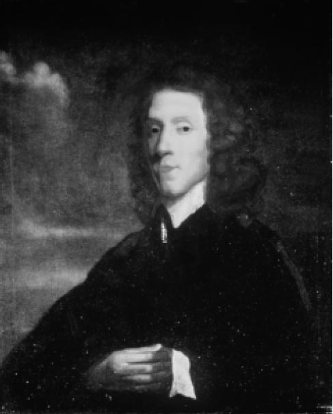 Figure 12. Portrait of John Page.
County," a position he held only briefly since less than a year later he was known as the "former sherrif of York Co." (YCR, DOW 6: 21,44). Page was distinguished by the title of "colonel," and he would have been responsible for civil and military affairs within York County (Palmer 1875:270; Wright 1940:52-53). His fellow York County residents elected him to membership on the Bruton Parish vestry. Rising above local county offices, he achieved an appointment to the Council of State in 1680.
Figure 12. Portrait of John Page.
County," a position he held only briefly since less than a year later he was known as the "former sherrif of York Co." (YCR, DOW 6: 21,44). Page was distinguished by the title of "colonel," and he would have been responsible for civil and military affairs within York County (Palmer 1875:270; Wright 1940:52-53). His fellow York County residents elected him to membership on the Bruton Parish vestry. Rising above local county offices, he achieved an appointment to the Council of State in 1680.
The avenue to such offices was not difficult for men like John Page. To seventeenth-century colonists, leadership was not democratic. Local and regional leaders in both England and Virginia were chosen from among the social elite and little distinction was made between social leadership and political leadership. Men of higher status viewed leadership as their exclusive prerogative (Bailyn 1959:91). Nowhere was this tacit assumption about who would lead the locality or the region more fully in evidence than in Virginia's Council of State. By the end of the seventeenth century the Council was the most powerful institution in Virginia, more powerful than the House of Burgesses, and increasingly more powerful than the Governor. To be a member of the Council one had to be a planter and a man of considerable wealth (Wright 1940:54; Greene 1963:26-27; Bruce 1910, 2:358-61).
When Page was chosen to sit on the Council in 1680, he also acquired the opportunity to add to his already wealthy estate. Members of the Council in seventeenth-century Virginia were able to enjoy a wide range of financial perquisites. In addition to the 350 pounds a councilor received in salary, he was also eligible for offices such as collector of escheats or secretary of state. The lucrative benefits that Page received for his government service were considered "the due of anyone who served in an office as lofty as the council, down to a lesser office in the county"(Wright 1940:55) . As Wright observed, even the smaller offices carried with them considerable privileges for the men lucky enough to land them. The position of sheriff, for example, entitled a man to collect a wide variety of fees. As "high sherriffe of Yorke County" in 1677, Page was entitled to collect fees, given in pounds of tobacco, for delivering subpoenas, for making arrests, for sending men to prison or releasing them, or for punishing a man physically according to the law. He also received fees based on judgments on a man's property (Bruce 1910, 1:600). The large number of men enriching themselves at the expense of their neighbors caused many complaints about the distribution of power and its abuse. At the end of the century, James Blair complained that plural office holding and the monopoly of power that lay in the hands of the Governor and Council were detrimental to the colony (Morgan 1975:207-8; Kamman 1966:150; Bruce 1910, 2:588-91).
33In his rapid rise within the hierarchy of offices and appointments in colonial Virginia, Page followed a pattern common to many men who arrived in Virginia in the years surrounding the Restoration. Page arrived in York County in 1655, a man from a prosperous English family, who was determined to make his way in Virginia. He was part of the second permanently-settled generation of Virginia's elite. The first generation was not necessarily comprised of men of eminence from England. They were distinguished instead by their ability to carve an existence out of the wilderness. George Menifie, Samuel Mathews, John Utie and others belonged to this group. These men controlled Virginia politics, indeed they ousted a governor, but they did not comprise a self-conscious ruling elite. "They succeeded," wrote Bernard Bailyn, "not because of, but despite, whatever gentility they may have had"(Bailyn 1959:9295). But their political and social success was short-lived since not one of these men nor their progeny survived to continue to dominate Virginia government.
Page's generation was different. He and his compatriots founded the family dynasties that would dominate Virginia in the eighteenth century. These men were not rough-hewn frontiersmen but were usually second sons of respectable English families, who because of primogeniture had found no prospects in English landowning. Nor did they have the capital to establish sugar plantations in the Caribbean. They migrated to Virginia, often because of some earlier investment in the Virginia Company, and acquired land and servants enough to grow tobacco. Governor William Berkeley exemplified this pattern. He was a second son whose arrival in Virginia owed much to his family's earlier investments in the Virginia Company (Bailyn 1959:98-99; Greene 1963:22-23; Shammas 1979).
Men came to seventeenth-century Virginia to improve their lot in the world. For men of John Page's social rank such success came at the expense of others. They used their connections and prestige to secure offices and positions that provided opportunities to pad their pockets while growing richer still through the sale of tobacco from their plantations. For Page, and the men he associated with, the apex of this political and social maneuvering was an appointment to the Governor's Council. Membership in the Council meant a man had reached the highest layer of Virginia society. Those with the social standing to sit on the Council controlled both the political and economic life of the colony (Wright 1940:54-55).
Building an Estate
Still, Virginia did not have a particularly good reputation. To be in Virginia was distinctly inferior to being in England and inferior even to owning a plantation on the sugar islands. So these colonists used their capital and family connections to pursue material gains and the growth of their plantations (Shammas 1979). As a result, wealthy Virginians turned their attention toward building their estates in an effort to emulate their English countrymen.
Page not only built up his home plantation, he also acquired land throughout the colony. In 1683, John Page came into possession of a tract of land in James City County known as Neck of Land. This land had originally belonged to John's brother Matthew. When Matthew died it was bequeathed to his son Matthew Page. John Page acquired the land when he paid 140 pounds for buying his nephew out of slavery in Algiers "& cloathing him att London"(YCR, DOW 9:103). Page also owned land in New Kent County. In 1672, he had patented more than three thousand acres of land in two parcels. 34 At least part of the land had become a working plantation called Mehixton by the time Page wrote his will in 1686/7. At that time Page had servants, slaves, livestock and household goods at Mehixton (Nugent 1977:30; YCR, DOW 9:103).
John Page also owned land at Jamestown. In 1673, Page, listed as a merchant in York County, purchased a three-acre parcel of land from the executors of the Walter Chiles estate (Ambler Manuscripts, 24, 1673). The deed lists two structures on the property. The oldest of these was a brick house built by Richard Kemp in 1638, while the second, a brick house measuring 37 feet long, was constructed near the existing structure by Walter Chiles sometime after 1653. Although it is not known whether Kemp's house was habitable when Page purchased the property in 1673, the subsequent deed for the sale of the property to William Sherwood in 1682 describes it as "ruins" (Ambler Manuscripts 1673:34).
John Page's other substantial land holdings were in Middle Plantation. These lands included much of what was to become Williamsburg. His Middle Plantation tract included present-day Duke of Gloucester Street, Nicholson Street, and part of Francis Street. In 1683 he patented three hundred thirty acres of land in two tracts. One of the tracts, containing two hundred eighty acres, was bounded as follows:
… beginning at a meare stone that stands in the Trench where the old pales stood on the North Side of the Roade, that leades through the Middle plantacon towards James Citty, and from thence Runing East by South one hundred pole to a Marked white oake, thence East Eight degrees South, One hundred seventy two poles to a Corner Red Oake, that Divides this land from the land of William Dyer, thence North by East Sixty poles to a Corner Red Oake, thence east nine degrees South One hundred thirty three poles and a halfe to meare stone att the head of this Land, thence North by East sixty two poles to a forked Poplar, thence West by North One hundred and Eight poles to a marked Hickary in a Valley, thence North West Westerly one Hundred and Sixty poles to a Corner of a Ditch, where the old pales stood, thence South West five degrees west one hundred poles to an old Poplar Stump, thence along the old pales trench South West Eight Degrees west one hundred fifty nine poles, to the place first Specified(Virginia State Land Office, Patent Book 7 (167989) 280).
Page had originally acquired one hundred of these acres in 1655, soon after he arrived in the colony. At that time he purchased a tract of land from Colonel George Reade, which included the Bruton Heights School property, with the following boundaries:
All that One hundred Acres of Land being freehold scituate lying & being upon the Pallizadoe of the Middle Plantation in the County of York in Virginia which late was the land of Nicholas Brooke Junior and by him granted to Capt. Robert higgenson & by Pattent from Richard bennett Esqr & Governor of Virginia beareing the date ye 13th: of Octobr 1652 Granted to Lewis Burrell & Lucy his wife heire to the sd Robt Higginson and by Coll. William Bernard and by the sd Lucy his wife granted & sold unto the sd George Read as by an Indorsement upon the sd Patten appeareth beareing date the 28th of November 1653. Bounded South East upon the land of John Broach and Northwest upon the Pallyzadoe (YCR, DOW I:159-69).
John Page was a prolific builder and his land near Williamsburg soon contained numerous buildings. Shortly after the founding of Williamsburg, and thirteen years after John Page's death, the colony's leaders made plans to remove buildings from the middle of Duke of Gloucester Street that now belonged to his nephew, also named John Page. On April 27, the burgesses recommended that:
the old house belonging to Mr. John Page standing in the middle of Gloucester Street 35 be pulled downe that the prospect of the Street between the Capitol and the Colledge may be cleer and that you take care to pay what you shall judge those houses to be worth(Journal of the House of Burgesses, (4) 55).
By May 5, the Burgesses determined to pay the younger John Page three pounds for "the old houses which stand on Gloucester Street." They then ordered that:
Mr. Henry Cary forthwith Sett the laboureres imployed about the building of the Capitol to pull down the four old Houses and Oven belonging to Mr. John Page which stand on Gloucester Street And have been appraised and that they lay the Bricks out of the Street on the Lott of the Said John Page(Journal of the House of Burgesses :4: 69).
The description of the houses as "old" suggests that they were probably built while the elder John Page was alive.
Archaeological Clues in the Landscape
During John Page's lifetime, the area that became Williamsburg was still undeveloped. Page chose the broad elevated terrace at Bruton Heights as the site for his manor house (Fig. 13). This property, which Page purchased in 1655, was probably covered in grassland with trees surrounding the ravines and dotting the terrain. Botanical remains recovered from kiln-related features dating to the 1660s included evidence of tulip polar as well as grasses that are common in meadows and along the edges of cultivated fields.
A fenceline, identified during the excavation of the Page kiln site east of the extant school building, provides the earliest indication of historic-period activity on the Bruton Heights property (Fig. 14). The remains of twelve postholes aligned on a northerly axis marked the location of the fenceposts. The holes averaged 10 inches on a side and only 5 inches in depth, which shows the toll that plowing and landscaping took on the remains of this early landscape feature. The 9'6" interval between the postholes indicates a post and rail fence.
The post and rail fence originated in Europe and saw widespread use throughout the colony by the mid-seventeenth century. Fences of this type were used to enclose a variety of activity areas including fields, pastures, orchards, gardens, and domestic yards. Post and rail fences quickly supplanted paled and worm fences because they required less wood and they were less labor intensive to construct (Patrick 1983:24-25). Typically, the Virginia post and rail fence was about five feet high and consisted of five rails per eight foot section. Decay-resistant woods such as locust, chestnut, cedar, and cypress were the preferred material for posts while oak, poplar, chestnut and pine were favored for use as rails (Patrick 1983:25).
The early fenceline identified at Bruton Heights appears, given the small size of the holes, to have been considerably less substantial than later fences discovered on the property. Postmolds marking the rotted remains of original posts were identified in only two of the twelve holes and artifacts were recovered from only two holes. These include a small fragment of brick discovered in a posthole near the southern end of the line and nine badly degraded fragments of Venetian glass recovered from an adjacent hole to the north. The presence of Venetian glass indicates
that this feature stood sometime during the mid-seventeenth century, since the English glass making industry did not begin to supplant Italian glass until the second half of the seventeenth century (Godfrey 1975:135). The near absence of cultural material indicates that the fenceline is one of the earliest features at Bruton Heights. Further, because one of the postholes was cut
36
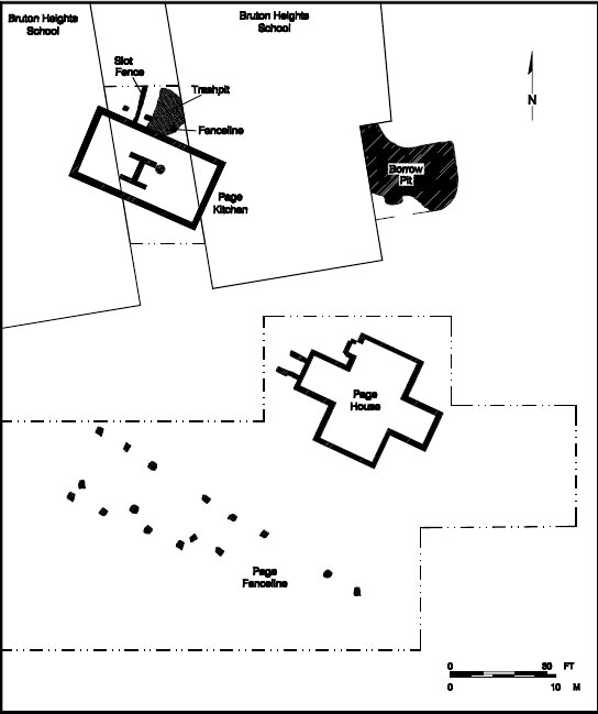 Figure 13. John Page's home site.
by a kiln-related feature dating to the 1660s, the fence must have predated the brick and roofing tile production site. The presence of this early fence suggests that Page may have occupied, or at least used, the Bruton Heights property prior to the construction of his brick manor house in 1662.
Figure 13. John Page's home site.
by a kiln-related feature dating to the 1660s, the fence must have predated the brick and roofing tile production site. The presence of this early fence suggests that Page may have occupied, or at least used, the Bruton Heights property prior to the construction of his brick manor house in 1662.
Bruton Heights witnessed a period of significant development in the 1660s that no doubt reflected Page's rise to a position of power. He established a sophisticated brick and roofing tile kiln of the type used to supply English manorial estates with construction materials for large projects or multiple structures. At least seven of the structures that Page built at Middle Plantation were executed in brick. Perhaps more surprising is the archaeological evidence that Page used ceramic peg tiles to cover his buildings.
That John Page chose to build in brick when most of his neighbors built less solid structures, and that he chose to cover his scattered brick buildings with tile, when few people in the colony used tile, suggests that
37
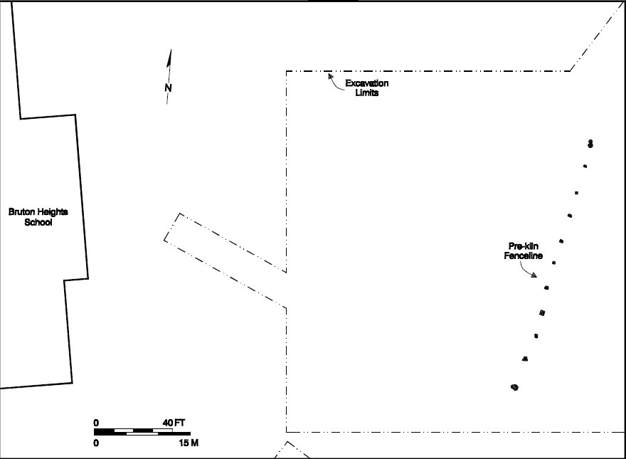 Figure 14. Remains of fenceline from the earliest period of Page ownership.
he was perhaps emulating a standard of wealth and status familiar to him in England. Architectural historian Dell Upton has noted that brick was "always an exceptional building material in Virginia; its use in any house is a sign of considerable wealth" (Upton 1990:71). The scanty evidence about tiles in the Virginia documents indicates that the use of such material was far preferable to the readily available pine or cypress shingle. Artisans possessing the ability to produce ceramic roofing tiles appeared in Virginia during the seventeenth century. The author of a 1648 propaganda tract stated that the production of tile was a more complex process than the production of brick and that, consequently, colonists found it difficult to acquire tiles for their structures:
Figure 14. Remains of fenceline from the earliest period of Page ownership.
he was perhaps emulating a standard of wealth and status familiar to him in England. Architectural historian Dell Upton has noted that brick was "always an exceptional building material in Virginia; its use in any house is a sign of considerable wealth" (Upton 1990:71). The scanty evidence about tiles in the Virginia documents indicates that the use of such material was far preferable to the readily available pine or cypress shingle. Artisans possessing the ability to produce ceramic roofing tiles appeared in Virginia during the seventeenth century. The author of a 1648 propaganda tract stated that the production of tile was a more complex process than the production of brick and that, consequently, colonists found it difficult to acquire tiles for their structures:
That they have lime in abundance made for their houses, store of bricks made, and house and chimnies built of brick, and some wood high and fair, covered with shingle for tile, yet they have none that make them, wanting workmen; in that trade the brick makers have not the art to do it, it shrinketh(Anonymous 1648: 67).
Little had changed by 1705, thirteen years after John Page's death, when Robert Beverley reported that Virginians had covered their houses mostly in shingles or thin clapboard:
They have Slate enough in some particular parts of the Country and as strong Clay as can be desired for making of Tile, yet they have very few tiled Houses(Beverley 1705: 290).
In one of the many town acts that called for the rebuilding of Jamestown, slate or tile was the desired roofing material, presumably because the proximity of the houses created a fire hazard (Hening 1823, II:172). John Page's neighbor, William Byrd, so desired tile as a roofing material that he ordered it imported from England (Byrd 1689, I:111).
38The ability to successfully produce high quality, affordable roofing tile seems to have eluded domestic potters until the late eighteenth century. Even then, the results were not always desirable. In Bethabara, North Carolina, Moravian elders complained bitterly about their problems making roofing tiles and the poor quality of those that were produced. Ultimately, the Brethren decided that "the tilery should not be repaired further since it does not seem possible to get any roof tiles made here. Whereas for the making of brick we do not need such a costly building" (Auf. Col. 23 November 1780). Doubts about the quality of American tile persisted into the nineteenth century. An advertisement for John Christian Smith's tilery placed in Charleston, South Carolina's City Gazette and Daily Examiner in 1800 confirms these doubts. The ad claims that Smith's tiles exceed the quality of imported tiles, refuting
an opinion entertained by some, that no Tiles could be made in South-Carolina, nor in America, equal to those imported from Holland or England(Anonymous 1800:3-4).
John Page's use of this scarce product underscores the extent to which the buildings on his Middle Plantation land were meant to communicate wealth and status to his neighbors and countrymen. Indeed, roofing tile analysis and historical evidence suggests that he may have tiled the building in which his son lived after 1679.
In that year, John Page gave 168 acres of land to his son Francis. This land was described as:
All those my three parcells of Land bounding on the old pallizado at Middle Plantation lying and being without the forest. That is to say fifty Acres of Land bought of Henry Wyatt the fifteenth of January 1671/2 60 odd acres of land bought of John White 4 Feb. 1673/4 of George Bates the sixteenth Day of March 1673/4 all wch parcells of Land bound on each other and lying altogether as by the Deeds of Sale and assignment of Bates pattent and by the records of Yorke County(YCR,DOW 6:128).
The gift, which included eight slaves, was probably meant to help Francis Page establish his own household and farm. The timing of the gift may have corresponded with Francis Page's marriage to Mary Digges. It is also possible that Francis Page was educated in England, and that the deed of gift corresponded to his return to the colony. At some point in the next dozen years, Francis Page had a dwelling house on the property. His house later became the "usual & accustomed place at middle plantation" for keeping a tavern (YCR,DOW 6:385).
Page's architectural tastes appear ambitious when viewed in the architectural context of the period. While brick architecture remained the ideal in the aspirations for the Virginia colony throughout the seventeenth century, the reality ran counter to the optimism of the recruiting pamphlets. In 1584, Richard Haklyut listed brickmakers and bricklayers among the essential tradesmen needed to establish a colony in Virginia (Noìl Hume 1963:20). In 1623, it was reported that "There is good store of earth fitt to make brick in almost every place; And heretofore much Brick hath ben made in the Contrie"(Kingsbury 1935, IV:260). Nonetheless, evidence suggests that poor and wealthy alike constructed a type of post structure which became known as the "Virginia style" house. Labor and capital-intensive tobacco monoculture quickly taught colonists how to "allocate time, energy, and resources to those activities that would contribute soonest to making a living"(Carson et al. 1988:149). The pervasiveness of this building tradition prompted Fraser Neiman to argue that "the paucity of extant seventeenth-century houses in Virginia underscores the fact that post construction was not only used by Virginians of all ranks, but employed almost to 39 the exclusion of all other methods"(Neiman 1984:300). Colonists continued to build earthfast structures after 1650, even when the number of brickmakers increased. Several of Virginia's royal governors tried to supplant post construction by sponsoring legislation designed to promote the use of brick and roofing tile. One example is the Cohabitation Act of 1662 which stipulated that thirty brick houses should be built at Jamestown and covered with "slate or tile"(Hening 1969, II:172). The statute also specified that the brickmakers needed to complete the construction at Jamestown would be recruited from throughout the colony.
Brick and Tile Manufacture at Bruton Heights
The brickyard on the Bruton Heights school property represents a large undertaking for the period. The archaeological evidence includes an irrigation trench, three clay tempering areas, possible locations of pugmills and water barrels, and an earthfast structure, all symmetrically organized around a single kiln (Fig. 15). The placement of the activity areas reflects the different stations involved in the process. Edward Dobson noted that "the arrangement of the several buildings varies with each yard more or less; but the principle on which they are laid out is the same in all cases, viz., to advance towards the kiln at each process, so as to avoid all unnecessary labor"(Dobson 1971, I:59) .
Clay Borrow Pit
The extraction of the clay used to make tiles and bricks at the Page kiln took place on site, where the availability of the clay helped determine where to place the kiln. Only one large extraction pit was uncovered during
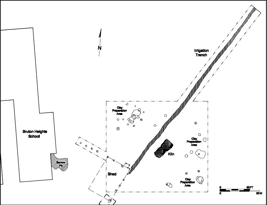 Figure 15. Kiln complex.
40
this excavation. Part of this irregularly-shaped feature, located just west of the kiln complex, extends under the school building. Only partially
uncovered, this pit measured in excess of 50 by 37 feet. The top of this feature was removed by plowing, but it survived to a depth of from just a few inches in some places to 4' in others. After the clay for tile and brick making was removed, the pit was abandoned and slowly silted in. It would have taken several years for the pit to completely fill in, as evidenced both by numerous water-deposited layers, and by the manufacture dates of artifacts found in the fill layers. The earliest layers of this feature contain artifacts, including several shaft and globe wine bottle fragments, that date to sometime after mid-century. The latest surviving layer contained a Charles II farthing dated 1672. A few artifacts including several hoes may be remnants of tools that were actually used in the creation of the pit or brick making nearby.
Figure 15. Kiln complex.
40
this excavation. Part of this irregularly-shaped feature, located just west of the kiln complex, extends under the school building. Only partially
uncovered, this pit measured in excess of 50 by 37 feet. The top of this feature was removed by plowing, but it survived to a depth of from just a few inches in some places to 4' in others. After the clay for tile and brick making was removed, the pit was abandoned and slowly silted in. It would have taken several years for the pit to completely fill in, as evidenced both by numerous water-deposited layers, and by the manufacture dates of artifacts found in the fill layers. The earliest layers of this feature contain artifacts, including several shaft and globe wine bottle fragments, that date to sometime after mid-century. The latest surviving layer contained a Charles II farthing dated 1672. A few artifacts including several hoes may be remnants of tools that were actually used in the creation of the pit or brick making nearby.
Clay Preparation Areas
The beginning of the production cycle is represented by three clay tempering areas. Seventeenth- and eighteenth-century sources state that tile makers commonly weathered the clay in close proximity to the molding area to reduce the distance clay had to be carried between stations. Dobson's nineteenth-century treatise on brick and tile manufacture indicates that clay for roofing tiles was then spread in thin, circular pads two inches deep to allow for a more thorough weathering. Two of the clay pads were found east of the kiln while the other was found seventy-five feet northeast of the kiln. Each feature contained evidence of plow scarring, which destroyed the integrity of the remains. The clay pad located in the northwest corner of the site extended 29' on a northeast/southwest axis. This feature was sectioned lengthwise and the eastern half removed. It measured nearly 10 feet wide and 2 inches deep. A single wrought nail was recovered from this clay pad. The clay feature located sixteen feet southeast of the kiln had experienced the greatest degree of disturbance. Plowing had removed all but three thin strips of dark brown sandy clay fill from the feature. Despite this, it was determined that the feature had measured at least 15 by 15 feet and averaged 2 inches in depth. A brick fragment, a piece of window glass, and a piece of case bottle glass were recovered from this feature. The smallest of these features was located fourteen feet northeast of the kiln. Evidence of the thin clay anomaly in the eastern sidewall of the project area suggests this smaller feature was a part of the larger clay pad to the south. The arrangement of the possible pugmill features also indicates that a single, large clay tempering area was located in the northwest corner of the brickyard.
Pugmills and Water Barrels
The clay pads were surrounded by fourteen circular soil stains. Five of the features resembled shallow bowls (Figs. 16 and 17), while the remaining nine contained cones of clay in the center. The features with conical bases were probably the remains of pugmills (Fig. 18). In his 1830 study of the English brick and tile industry, Dobson states that unlike
the clay for bricks, the clay used for tiles was ground in a pugmill (Dobson 1971, I:107). The base of the tub was buried for support while the spindle rested on the cone. Clay was fed into the barrel at the top while blades on the revolving spindle forced the clay down and out through a hole at the base of the tub. Responding to an assertion that manual tempering by treading was superior to pugging, Dobson argues that the pugmill "does its work very thoroughly, and
41 Figure 16. Water barrel hole. Figure 17. Cross-section of water barrel hole.
 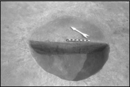 Figure 17. Cross-section of water barrel hole.
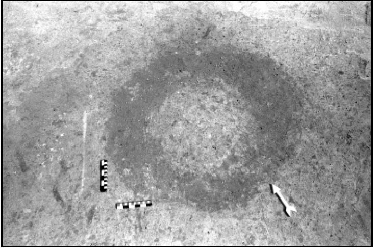 Figure 18. Unexcavated pugmill.
its use prevents the chance of the tempering being imperfectly performed"(Dobson 1971, I:26).
Figure 18. Unexcavated pugmill.
its use prevents the chance of the tempering being imperfectly performed"(Dobson 1971, I:26).
The remaining five circular features had flat bottoms. They were interspersed among those features with conical bases. Mixing clay required a readily accessible source of water, so it is possible that these features mark the location of water tubs. Water barrels were placed near the tempering areas for soaking or malming the clay before it was pugged.
Irrigation Trench
An irrigation trench extended more than 300 feet on a northeast/southwest axis through the project area into the forested area along the northern boundary of the school parcel. The end of the trench was not found. Water was essential to all aspects of brick making and trenches were often dug to provide the various activity areas with water. In fact, Houghton's guide states that "a well must be dug"(Houghton 1683:196) . 42 Near the north end of the trench must have been either a well or a natural spring. The trench sloped slightly to the north, descending 4 feet over 300 feet. In order to get water up this slight slope, the water level in the trench must have exceeded 4 feet.
The irrigation trench terminated at the corner of a possible earthfast structure located in the southwest corner of the project area. Excavation revealed that the trench conformed to the corner of the structure suggesting it was dug to deliver water to this area. The fill at the southern end of the trench differed from fill encountered elsewhere in the feature in that it appeared to have been intentionally filled with brick rubble when the site was abandoned. A chisel, three broad hoes, and a narrow hoe were discovered in the irrigation trench. These items were related to brick and tile manufacturing. Hoes were used to mix clay while chisels were often used to separate fused tiles.
A post situated on the eastern side of the trench across from the post structure appears to have been removed and filled with rubble at the same time the southern end of the trench was filled. This may have been part of a structure for a well hoist to provide water to the structure. Dobson stated that well hoists were in use in England in the early nineteenth century and may have been used earlier (Dobson 1971, II:43).
Earthfast Structure
Evidence discovered in association with the trench suggests that a shed measuring approximately 36 by 25 feet was constructed on site. These remains were identified in the southwest corner of the project area, approximately forty feet southwest of the kiln. This structure probably served as the molding and drying shed for the operation. Covered areas were essential to protect the drying bricks and tiles from the elements, and buildings of this size were common on English and French brickyards by the seventeenth century. Evidence of several work sheds was uncovered during the excavation of a seventeenth-century brick and roofing tile kiln in Danbury, Essex (Drury 1975).
Eight postholes define the eastern and northern walls of the structure at Bruton Heights while the remaining two walls are presumed to lie buried beyond the confines of the excavation area. The postholes are typical for structural posts in that they are very large and regular, averaging 2'6" by 2'6". Postmolds, set off as dark organic stains in the center of orange clay posthole fill, suggest that the posts themselves measured 7 inches on a side and had been squared-off and dressed. Two of the holes showed evidence of repair or replacement. The postholes averaged 1'6" in depth. The base elevation of the holes fell within 1½ " of one another, which suggests that the holes were excavated to seat the framing members of a structure. Scholars experimenting with the construction of the earth-set "Virginia house" at Historic St. Mary's City in Maryland discovered that postholes had to be large enough for the mortise-and-tenon joints and excavated to uniform depths to allow the paired traverses or tie-beams to be raised evenly (Kelso 1984:62). The archaeological evidence of earth-set housing from Kingsmill and Hampton, Virginia, verify this observation (Kelso 1984; Edwards et al. 1988:1).
Based upon the existing evidence, the building appears to have been large, measuring at least 36 by 25 feet and consisted of four bays. Four additional posts abutting the northeast corner mark the position of a small shed measuring five feet on a side. One of the posts was seated next to a main structural post, indicating that the shed was added after the construction of the building. Molds measuring 7 inches in diameter 43 marked the position of the posts in each of the holes. The average surviving depth of the holes is 7 inches. Any evidence suggesting the existence of a fireplace or sills for a raised wooden floor was either plowed away or destroyed when the field was graded to make way for the school's baseball diamond. The absence of interior support studs, however, between the major structural posts might indicate the use of tie beam construction: studs could not have been added after the framing members were hoisted into place (Kelso 1984:68).
No temporally diagnostic artifacts were found in association with the structure. The artifacts recovered from the postholes included six nails, two fragments of a domestically produced tobacco pipe, a piece of glass, and two pieces of furniture hardware. The remains of wooden posts were removed from three of the holes, although they were too badly deteriorated to allow for accurate identification. This building appears to be an early part of the kiln activities and the notable absence of brick and tile fragments suggests that the structure was constructed prior to the first firing of the kiln. Moreover, the association of the building with the irrigation trench suggests that it was constructed as part of the brick and tile making enterprise.
Semi-Permanent Kiln
The centerpiece of the production site was a rectangular updraft-type kiln with an associated stoking pit (Fig. 19). The firebox and stoking pit are characteristic of a kiln type which appears to have originated with the Roman pit-kiln (Goldthwaite 1980:177). Kilns of this type remained largely unchanged until they were supplanted early in the eighteenth century by the Scotch kilns in permanent brick yards and the site-specific field kilns commonly called clamps.
The firebox measured 12' by 11'6" and was excavated to a depth of 3 feet. The flue openings of the Bruton Heights kiln were oriented toward the southwest in order to take advantage of the prevailing wind. This helped to increase the draft and promote more efficient use of fuel (Goldthwaite 1980:182). Three flues extended to the rear wall of the kiln. The vitrified outlines of the channels indicate that the channels were 3 feet high (Fig. 20). Placing all the intakes at one end of the kiln would result in a reduced atmosphere that would not have been able to provide sufficient oxygen for complete combustion. The tiles would have had dark cores and been of poor quality (Zug 1986:223; Davey 1961:65). A majority of the tiles from Bruton Heights show evidence of reduced cores.
The three arches at the front of the kiln were constructed of unmortared brick. The arch structure was the only permanent part of the kiln; it was not dismantled between firings. The remains of four permanent benches were also discovered, the outermost of these being almost completely intact. The two innermost benches extended 10' into the interior. The bricks in the remaining benches were probably left behind since their proximity to the hottest part of the kiln would cause them to be overfired and unsuitable for use in construction.
The walls and the floor of the kiln were unlined, which indicates that the kiln was semi-permanent. Evidence of scorching on the floor was greatest near the arched openings and diminished toward the back wall, another indication that a reduced atmosphere existed in the kiln. The lifespan of the Bruton Heights kiln is estimated to be between one and five years (McCarthy and Brooks 1988:46-47). There was no evidence of repair or relining, and the brick that was encountered in the kiln was friable due to over-firing.
44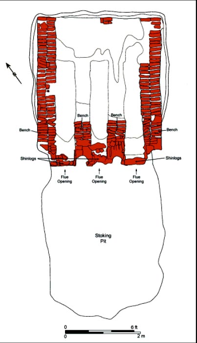 Figure 19. Plan view of kiln.
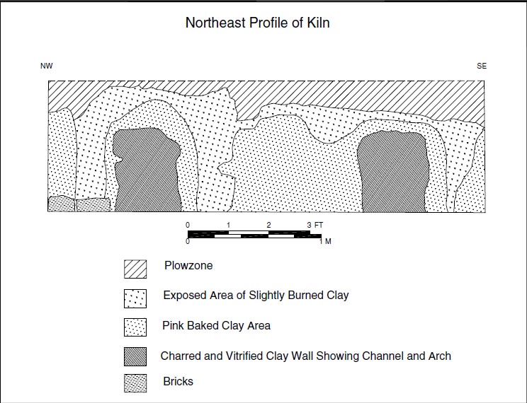 Figure 20. Cross-section of kiln fire box.
Corbels of green bricks placed in the firebox created the flues and the vented floor. The optimum height for an updraft kiln such as the one at Bruton Heights was fourteen feet above the ground surface. The capacity of the kiln would have been between 15,000 and 24,000 bricks and tiles per firing.
The kiln's firebox opened into an unlined clay pit known as a stoking pit. This area allowed the brickmaker access to the firebox during firing. The stoking hole extended 12' south from the opening of the kiln. Excavation revealed several layers of ash that protruded 6' 6" into the stoking pit from the arches of the kiln. Multiple layers of ash indicate that the Bruton Heights kiln was fired several times and that ashes from kiln were raked into the stoking pit to provide a tighter control over the firing temperature (Barka 1984:202). The temperature within the kiln was regulated by adjusting the bricks on top of the structure and by altering the height of the shinlogs at the eyes of the flues.
Social and Economic Implications
The brick and roofing tile manufactory at Bruton Heights is medieval in form and the first generation of artisans were medieval in style and practice. The desire to profit from tobacco may have encouraged artisans to abandon their craft. Trades did not die completely, however, because continued immigration throughout the seventeenth century maintained a population of artisans and craftspeople. A law passed in 1666 urged people to forgo planting and work at their trades, including most building trades. Brick making may have developed because brick is an example of a product that could not be shipped as cheaply as it could be produced domestically.
48The scale of the Bruton Heights brickyard appears to have been similar to brickyards on estates in England during the same period. Operations like these employed semi-permanent kilns to produce "aesthetically and compositionally superior bricks and tile" for a structure and its dependencies (Wight 1972:27-28). Estate projects were arranged through a building contractor and an itinerant maker burned the bricks and tiles on site for the duration of the project. According to Jane Wight, "it was probably most common for production to be a temporary affair, of a brickfield that was worked for three or four seasons, for a big house or for additions to a church"(Wight 1972:35). While these bricks and tiles were primarily for estate use, the surplus was often sold within the community (Fig. 22). Still,"it was rare for materials to be carried more than ten or twelve miles at most"(Wight 1972:32) .
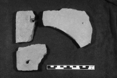 Figure 22. Tiles from Bruton Heights kiln.
Xero-radiographic analysis of the roofing tile from sixteen regional sites produced a similar pattern. Xero-radiography is a form of compositional analysis which employs an x-ray of the type used in mammography to provide an interior view of the ceramic fabric. Roofing tiles from three sites were similar enough in composition to have been produced at Bruton Heights. Not surprisingly, the secondary deposit of seventeenth-century domestic material from the Page kitchen/ quarter matched tile from the kiln located a few hundred yards to the east. The proximity of these two sites makes this rather obvious. Samples taken from the Nassau Street Ordinary matched those from the Bruton Heights kiln site and domestic assemblage, which suggests that these are the remains of the younger Page's dwelling and later tavern. Furthermore, this site also corresponds to the location of the gift of land John Page bestowed on his son (YCR, DOW 6:128).
More surprisingly tile fragments collected from the eastern end of New Towne on Jamestown Island also matched tiles from the Bruton Heights kiln. The tile came from a boundary ditch associated with the May-Hartwell House which was constructed between 1661 and 1662. The house was rebuilt in 1676 following Nathaniel Bacon's raid on 50 Jamestown and was abandoned shortly after 1695. Over 1000 fragments of roofing tile were recovered from ditch located southeast of the structure. The proximity of this ditch to a detached kitchen suggests a possible source of this material. The high quality of the artifacts found in the ditch, however, suggests they came from both the kitchen and its associated dwelling. The artifacts in the ditch date between 1680 and 1720.
While there is no direct Page connection to this property, John Page did own the Page/ Chiles tract northwest of the May-Hartwell tract. This might be evidence for the sale of surplus materials to others or some kind of informal exchange.
Brick became the material of choice in English construction during the seventeenth century. While brick was incorporated into vernacular architecture for use in foundations and chimneys, formal buildings were executed entirely in brick. Despite the qualitative change in the standard of building signaled by the increasing use of brick, the scale of brick construction remained a symbol of high social status. In fact, vernacular buildings of brick, such as small town houses, cottages, and agricultural structures continued 51 to be uncommon until the eighteenth century (Wight 1972:32-33).
While the Bruton Heights brick and tile making operation was unusual for the period, it reflects the beginning of a pattern that emerged in Virginia during the third quarter of the seventeenth century. Three kilns have been identified at Jamestown that are similar to the example at Bruton Heights in both form and product. The earliest is Structure 111 which may have been in operation as early as 1625 (Hudson 1957:46). This kiln appears to have provided brick for a private structure. Structure 127 dates to circa 1650 and appears to have provided brick and peg tile to a privately owned structure. Structure 102 is a much larger, brick-lined kiln which appears to have been built to provide brick and tile for several buildings or a public building project. John Cotter argues that this kiln dates to the 1670s or 1680s (Cotter 1958:26).
The growing acceptance of brick in Virginia may be linked to the trend toward greater political stability and economic diversification which began to take hold in the second half of the seventeenth century. In eastern England, the increase in brick architecture is associated with the growth of sheep farming, weaving and other trades during the fifteenth century (Wight 1972:18). Brick making as part of the larger construction industry was touted as the "chiefest promoter of trade"; however, capital investment was essential for the development of this lengthy and labor intensive pursuit (Wight 1972:18). The entire Chesapeake economy was organized around tobacco, cattle, and maize throughout the seventeenth century and capital was reinvested first in tobacco. The rise of brick use in Virginia occurred during the second half of the century when tobacco prices fell and colonists began to diversify. The Page family certainly appears to have been economically diverse. John Page's large landholdings suggest that he was engaged in land speculation, while the mention of a "brick mault house" in the 1692 will of Francis Page suggests that the Page family deviated from tobacco monoculture and engaged in mixed agriculture prior to 1700.
The Manufacture of Brick and Tile
The brick and tile making process John Page would have known was both expensive and time-consuming. The cost of rebuilding the middle and lower Middlesex County churches in Virginia between 1710 and 1717, for example, was equivalent to half the expenses for the county and court vestry for the previous decade (Rutman and Rutman 1984:202). Despite the fact that ceramic tiles were an excellent roofing material, the special knowledge required for their manufacture and the lack of artisans who could produce them represented an added expense that placed them out of reach to all but a wealthy few. Brick and tile making had also become strictly regulated by the seventeenth century, with highly standardized processes that were brought to English North America by skilled craftsmen. In London, statutes requiring that slate or roofing tile be used to prevent fire were enacted as early as 1189 (Wight 1972:27). Building by-laws passed in London in 1212 suggest that the manufacture of roofing tile was well established by the thirteenth century (Salzman 1952:140, 223). The importance of roofing tile in England correlates with urbanization and the fire hazard which resulted from living in such close quarters.
The Statute of 1477 standardized the manufacturing process and set specifications for flat tiles:
Clay shall be digged and cast up before the first day of November — the same Earth be stirred and turned before the first day of February — and not wrought before the first day of March — and also that the veins called Malm or marle, and Chalk, lying commonly in the ground …shall be … severed and cast from the said Earth — Every such plain tile … shall contain in length ten inches and a half, and in breadth six inches and a quarter of an inch, and in thickness half an inch and half a quarter at the least(Davey 1961:159).
These measures were prompted by decreasing quality and the increasing variability in the size of the product which made repairs very difficult. Consumers complained that tiles lasted only four or five years when they should have lasted forty or fifty (Salzman 1952:230). Brick and tile making guilds enforced regulations in order to raise and maintain the quality of materials produced. Municipalities levied fines against tilemakers for breaking these codes (Salzman 1952:230; Lloyd 1928:50).
Brickmakers began production in the fall by digging enough clay for the following year. Edward Dobson, a nineteenth-century expert on the industry, observed that "success in attaining the desired end depends almost entirely on a proper selection of the brick earths and their judicious preparation" (Dobson 1971, I:12). While there was no standardized method of digging clay, English brickmakers preferred superficial deposits (Cox 1989:3; Davey 1961:158-159). Experiments show that the upper two feet of clay is the best for brick production (Davey 1961:65). The method of digging varied regionally. In Essex, England, for example, square pits measuring fourteen feet on a side or long narrow ditches between two and four feet in width were used (Cherry 1991:189). For the sake of efficiency, brickyards were often located on or near a clay source.
Once it was dug, the clay was taken to the brickyard where it was heaped and allowed to weather through the winter months. Exposure to the weather allowed the rain and frost to leach out destructive salts and caused the clay to expand and contract, thereby increasing its plasticity. The brick and tile making process began in earnest after Christmas. Houghton's construction manual, written in 1668, states that brick and tile making provided work for four men and two boys throughout the production cycle (Houghton 1683:189). While the brickmaker was the only position that required specialized knowledge of the brick and tile making process, each member of the crew performed specific functions. A technical vocabulary defining these individual roles had developed by the seventeenth century (Houghton 1683).
First, the clay was tempered. The workman responsible for tempering and mixing the clay was known as the earthmaker. He removed pebbles and soaked or malmed the clay to remove remaining salts. Edward Dobson noted that malming "frees [the clay] from stones and hard lumps" to create a homogenous mixture (Dobson 1971, I:24). Once the pebbles and salts were removed, the earthmaker added sand and ash to achieve the proper consistency. Clays were mixed at this stage to produce an even consistency and increase plasticity. Traditionally, English brickmakers mixed the clay in shallow pits where laborers or animals tread the clay to the proper consistency. Pugmills and horse-driven edge mills appeared in Italian brickyards by the sixteenth century and in English brickyards in the seventeenth century (Cox 1989:5). The origin of mechanical mills remains unclear due to the fact that brick and tile making were largely traditional crafts whose methods were passed on orally between generations.
The next stage of the process, soiling, was accomplished by adding a mixture of ashes and street sweepings called Spanish or breeze to the clay (Cox 1989:4). This practice caused the actual clay to burn while in the kiln. Soiling or breezing, which creates a more efficient firing atmosphere by increasing the heat with less fuel, appears to have begun in the mid-seventeenth century when the supply of wood began to diminish in England. In 1714, the Company of Brickmakers and Tilers in London stated that the practice of adding Spanish began:
about forty years since, occasioned by diging up several fields contigious to the city after the great fire which fields having ben much dunged with ashes it was observed the bricks made with the earth in those fields would be sufficiently burned with one half of the coles commonly used. Brick and tile making recommenced in March when the clay was turned over and tempered. Pebbles and other large inclusions are removed to prevent the brick from cracking when it is dried and burned. Water is added to increase the plasticity of the clay(Cox 1989:4).
 Figure 21. Woodcut of brickmaking (from Amman and Sachs 1973).
Once the clay reached the proper consistency, a laborer called a carter loaded clay on a cart and took it to the molding shed. Then, the molder's assistant, a boy known as the upstriker, took the clay from the cart and laid it on the molding table. The molder placed the clay in a mold for roofing tile or brick. Bricks were either slop molded or pallet molded to keep them from sticking to the molds. Slop molding could be done by one person who dipped the mold in water from time to time to prevent the clay from sticking. Pallet molding, on the other hand, involved sanding the mold and normally required both a molder and a upstriker or clot molder who placed the wet clay into the mold (Dobson 1971, I:30). The differences between these methods were often overlooked by brickmakers. In fact, many operations combined elements from the two processes depending on the clay's consistency and stickiness. Dobson asserts that 10,000 bricks per week was a "high average" for a slop molder while a London pallet molder was capable of turning out 36,000 bricks per week (Dobson 1971, I:30). A more realistic production rate for the Bruton Heights kiln site comes from a seventeenth- century builders guide that indicates that "a man without help will make a thousand [bricks] in a day"(Houghton 1683:188) .
Once this was done, a boy known as an offbearer took the green brick and tile and laid them in rows on flat ground to air dry for 24 hours. The unfired product was watched carefully during this time to ensure that it did not remain wet or dry out too quickly. Slop molded bricks were "usually dried on flats or drying floors" and sand was sprinkled over the green bricks to absorb moisture (Dobson 1971, I:38). After the bricks and tiles were hard and dry enough to handle, the upganger moved them to the drying shed and stacked them to dry for up to three additional weeks. Here, green bricks and tiles had to be protected from gusts of wind so that one side of the product would not dry out faster than the other and crumble.
The brick making process culminated in the setting and burning of the kiln. The construction and preparation of a kiln for firing varied little over centuries. Loading the kiln required skilled labor to ensure that heat was distributed evenly. The molder was often the person who set and burned the kiln (Weldon 1990:23). He and his crew stacked green bricks in rows called benches that were three bricks wide. A space measuring a finger's width was left between each brick to allow for the circulation of heat throughout the kiln. Straw was spread across the benches every three courses. Benches alternated with channels or flues which held the wood fuel. They were stacked five or six courses high and were capped with brick corbel arches over the channels.
Kilns were typically stacked to a height of fourteen or fifteen feet. Edward Dobson estimated that an average size kiln measuring fifteen by twenty feet could hold up to 40,000 bricks per firing (Dobson 1971, I:41). Loads of 20,000 to 30,000 appear to have been more typical (Goldthwaite 1980:179). Common bricks were placed in the bottom to create the arches while the best bricks were placed in the middle where heat exposure was optimal. Common bricks were also used to encase the middle load and cover the top of the kiln. The entire structure of green bricks was then enclosed in a shell of fired bricks and plastered over with mud to insulate the kiln. Plugs of green brick called shinlogs were placed at the openings of the flues to allow the brickmaker to monitor the fire in the kiln without getting burned. Shinlogs were also raised and lowered to regulate the intensity of the heat within the kiln and to shift the distribution of the heat from side to side.
Burning lasted about a week and required constant attention. Twenty or thirty cords of wood were required to burn 60,000 bricks (O'Conner 1987:54). Burning the kiln began with a slow fire of about 200° C to dry the bricks and tiles. In the early stages the heat inside of the kiln was controlled by adjusting the bricks on top of the kiln to open or close airways. The brickmaker watched for the smoke rising from the kiln to turn from white to black, which signified that bricks and tiles were thoroughly dry. The fire was then stoked to between 900° and 1000° C for the duration of the burning (Smith 1985:54). From this point, the intensity and distribution of the flame was controlled by adding fuel and controlling the draft through the openings at the arches. Upon completion of the firing, the bricks and tiles were allowed to cool for several days before they were removed.
Bricks were fired in clamps and kilns throughout the seventeenth and eighteenth centuries. Edward Dobson described the clamp as "being only employed in burning bricks made with ashes or coal dust" (Dobson 1971, I:38). Nonetheless, the term became more widely used in brick making. Dobson recognized this, adding that "It should be observed, however, that the name of clamp is applied also to a pile of bricks arranged for burning in the ordinary way, and covered with a temporary casing of burnt brick to retain heat"(Dobson 1971, I:38) . The difference between a clamp and a kiln lies in the permanence of the structure. Clamps were temporary kilns constructed of the material they were producing. Once firing was complete, the clamp was dismantled, leaving only a footprint of burned soil and perhaps a few brick wasters. Kilns, on the other hand, were permanent structures built of brick or stone and consisted of a distinct firebox and stoking pit.
Clamps were generally site specific in that they were built to provide brick for a single project. Itinerant brickmakers often fired brick in clamps because they were less labor intensive and expensive to construct and burn. The major drawback of this kiln type was the inability to control the firing process. Clamps attained maximum heat almost immediately. Unlike the more permanent kilns, however, this heat could not be redistributed to other areas of the kiln. Consequently, clamp-fired material included a greater percentage of under- and over-burned wasters. Analysis of the brick making industry in Europe has shown that, although inefficient, clamps remained popular in areas where fuel was cheap (Goldthwaite 1980:187).
Dobson defined a kiln as "a chamber in which the green bricks are loosely stacked, with spaces between them for the passage of heat"(Dobson 1971, I:38). A common kiln type consisted of a platform over vaulted firing chambers with a walled area above that was open at the top, "like the Roman pit-type kiln" (Goldthwaite 1980:178). A floor consisting of a latticework of openings was built over the inground firing chambers to allow heat to rise efficiently. Permanent and semi-permanent updraft kilns had shorter burning times than clamps due to heavier construction and increased insulation which resulted in higher firing temperatures.
Unlike short-lived clamps, kilns were lined with a highly replaceable material such as under-fired brick which made them suitable for use on brickyards or for extremely large projects involving many firings. It has been estimated that the lining of a permanent kiln could last five to ten years (McCarthy and Brooks 1988:46). Unlined pit-type kilns were considered to be semipermanent. They were built to provide brick and tile for smaller projects or to manufacture specialty items that required carefully controlled firing (Eams 1961:167).
The earliest kilns in England appear to have been site-specific clamps. These were supplanted by more permanent kilns and brickyards as demand for brick and tile grew (Cox 1979:17; Crossley 1990:284). Eventually, the walled kiln with a subterranean firing chamber evolved into the Scotch-type kiln. Scotch kilns continued to develop during the eighteenth century and survived into the twentieth century when large scale commercial yards made smaller operations obsolete. While the permanent kiln developed as the mainstay of the brickyard, clamps supplanted the more permanent kilns in the countryside in the first years of the eighteenth century since brick making in the hinterlands remained a site specific endeavor practiced by itinerant craftsmen. Brick and tile making remained within the realm of these craftsmen due to the high cost of transportation and the availability of cheaper alternatives elsewhere (Chaloner and Musson 1986:14).
Although bricks and tiles were often fired in the same kiln, the production of roofing tiles required special attention. Tiles were a more refined product; they had to be very compact to prevent moisture and frost from permeating and causing the tile to crumble. The clay had to be finer and tempered more carefully because a greater surface area was exposed to the weather. Houghton's manual states that "Tiles are made of Earth much better than Bricks, inclining to that which Potters use" (Houghton 1693:26). The clay also had to be stiffer than brick clay (Dobson 1971, I:107). Tiles also required special attention in firing. Bricks were put down first and then tiles were "placed edgewise in parcels of twelve, changing their direction each parcel of twelve"(Dobson 1971, I:109-110). Tiles were placed in the middle of the firing platform for optimum exposure to the heat. Dobson states that "the uniformity of heat is the desideratum in firing" bricks and tiles (Dobson 1971, I:110).
52CHAPTER 5.
The Page Estate
The archaeological remains of the Page plantation at Bruton Heights suggest that the landscape John Page created was similar to others in Virginia. It included fences, ditches, and discrete activity areas that reflected the daily routine of a colonial homestead. Nonetheless, the Page estate also possessed elements that would have been recognizable to well-bred contemporaries back in England. John Page had the means to build in the manner of the English gentry. Moreover, the different components comprising the plantation as well as their layout suggest that Page drew on memories of the high-style English landscape to order his world in Virginia.
The Manor House
John Page's house was extremely well built, architecturally sophisticated, and spacious, particularly when compared to most Virginia houses (Fig. 23). The main section of the house measured 36' 9" by 21' 11" and was supplemented by two towers that measured 13' 5" by 13' 11" each. These towers on the front and back, called porch and stair towers respectively, gave the house a cross plan shape (Fig. 24). This layout was well known in England and was reproduced in Virginia, notably in Arthur Allen's 1665 home in Surry County, called "Bacon's Castle." It was also an important early house plan in the English colonies of Bermuda and Ireland. There, too, prominent men built solid cross-shaped dwellings.
Porch and stair towers not only distinguished the appearance of a house on the exterior but on the interior as well. Projecting off the house, these towers created a distinctiveness that communicated the owners' prominence. On the interior, towers created extra rooms that made the house more private and also acted as a barrier against the outside. Use of this style increased toward the end of the seventeenth century in Virginia with forty percent of the probate inventories from the 1680s listing porches or entries (Upton 1980:172). Cross-plan houses became outmoded during the second half of the eighteenth century as Georgian-style houses became more popular. The added rooms and central hallways of these double-piled houses created even more privacy (Upton 1980).
John Page's house was constructed entirely in brick and, based on the width of the foundation, might have stood one-and-a-half stories with two-story towers.1 Matching chimneys probably adorned both ends of the structure. The remnants of wooden steps that led up to the back door were also discovered behind the stair tower.
The roof was originally covered with ceramic roofing tiles manufactured at Page's brick and tile kiln. The small number of tile fragments retrieved from the cellar fill implies that most if not all of the tiles were replaced during subsequent renovations of the house. If the tile roof was intact when the house was destroyed, large numbers of tile fragments should be present in the cellar. Not only did tiles wear out but oak pegs, used to
54
Figure 23. Artist's reconstruction of the Page house (drawing by David Brown).
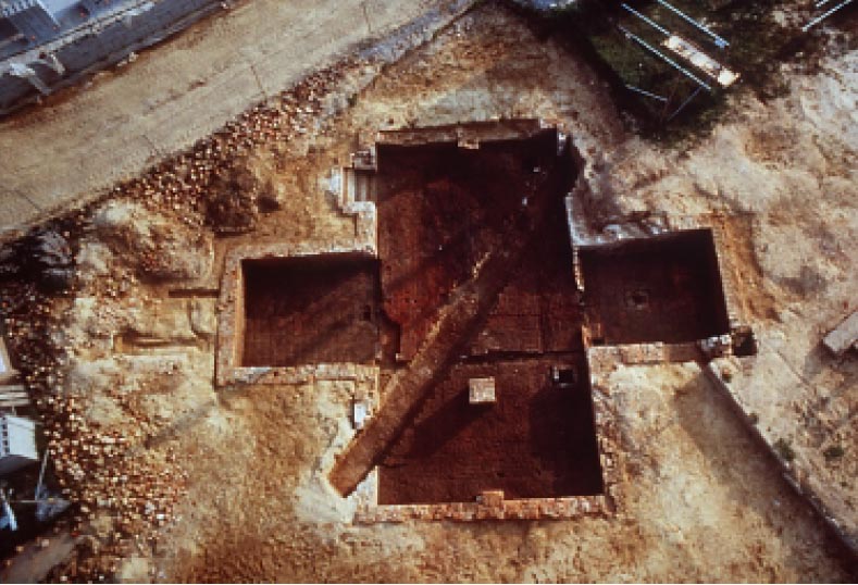 Figure 24. Excavated Page house cellar.
55
hold the tiles in place would eventually rot and fail, requiring the replacement of the roof. Page's house stood for approximately seventy years,
sufficient time for either the tiles or the pegs to give out.
Figure 24. Excavated Page house cellar.
55
hold the tiles in place would eventually rot and fail, requiring the replacement of the roof. Page's house stood for approximately seventy years,
sufficient time for either the tiles or the pegs to give out.
Evidence from the window leads that held the casement windows together suggests the windows may have been replaced as many as three times. The original 1662 windows were replaced sometime in the 1670s with leads that were impressed with a date of 1669 (Fig. 25). No dated leads from the original 1662 set were recovered, but numerous 1669 leads were found in features that were created while the house was standing indicating that some windows were later replaced a third time. No dated leads associated with the third set were found during any of the excavations. Possibly natural disaster or civil unrest caused Page to replace windows. Secretary Thomas Ludwell reported that 10,000 homes in Virginia and Maryland had been destroyed by a 1668 hurricane (Morton 1960). In 1676, Nathaniel Bacon's men plundered the homes and estates of prominent men who remained loyal to Governor Berkeley. After the rebellion Page attached his name to a list of people seeking compensation for losses incurred during the uprising. Page's house appears to have avoided extensive damage, however, since he hosted Berkeley before the Governor returned to his devastated Green Springs Plantation after the rebellion (Washburn 1957b).
No fireplaces were discovered, but evidence indicates they were located at the north and south ends of the house at the first floor level. Specially molded hearth-floor bricks, made at the Page kiln, were unearthed along both the north and south walls of the cellar, suggesting they fell from first-floor fireplaces (Fig. 26). Mixed in with the molded bricks found at the northern end of the cellar was worked slate, also probably used in the fireplace located on that end of the building.
A rendition of what is possibly the Page house was drawn in 1702 by a Swiss visitor named Francis Louis Michel, who did a number of drawings around Williamsburg (Fig. 27). Labeled "merchant's house," this drawing includes a depiction of a one-and-a-half story house with a small porch tower on the front (Michel 1701-1704). The owner of the house in 1702, John Page's nephew, also named John, was a merchant, and the house bears a coarse resemblance to what the Page house must have looked like. Michel also drew the Capitol, Bruton Parish Church, and the Wren Building, all of which are located within one mile of the Page house. Clearly he was in the neighborhood.
The elaborations on the outside of the house were also unique. Excavation revealed water table bricks and a number of other
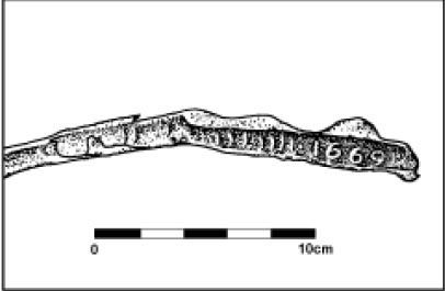 Figure 25. Window lead dated "1669."
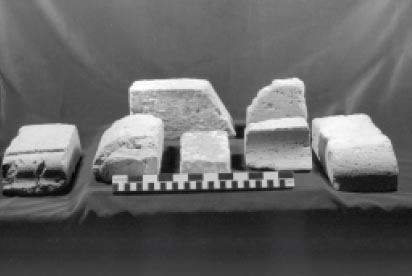 Figure 26. Carved and molded bricks.
56
Figure 26. Carved and molded bricks.
56
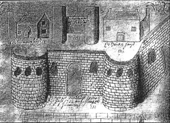 Figure 27. Michel drawing. The Merchant's house is shown on the top left (from Francis Louis Michel's drawing of Williamsburg, Colonial Williamsburg Foundation Library).
carved and molded bricks that once adorned the windows, doors, and roof line. The most intriguing find was a set of five bricks that featured a raised heart-shaped symbol and seven characters (Fig. 28). The letters "P" and "A" and the date 1662 are the initials of John and Alice Page and the date the house was constructed. Together these bricks would have formed a diamond shaped shield or cartouche that was probably located over the front door.2 The bricks were carved in bas-relief. Paint analysis revealed the background was originally painted off-white while the raised characters were burnt sienna. At a later date, when much of the original color had faded, the raised portion was repainted in a rather sloppy fashion with a white lead-based paint (Howlett and Swan 1996). Examples of cartouches with raised characters like this one are almost nonexistent for this time period in English North America. To date this is the only known example of this type of carved brickwork in the southern
colonies. Other houses do have cartouches but they are etched, not raised. An example of this can be found at Berkeley Plantation in Charles City County, where the initials of Benjamin and Ann Harrison IV and a heart sit above the date 1726. Although etched in stone, it is very similar to Page's cartouche.
Figure 27. Michel drawing. The Merchant's house is shown on the top left (from Francis Louis Michel's drawing of Williamsburg, Colonial Williamsburg Foundation Library).
carved and molded bricks that once adorned the windows, doors, and roof line. The most intriguing find was a set of five bricks that featured a raised heart-shaped symbol and seven characters (Fig. 28). The letters "P" and "A" and the date 1662 are the initials of John and Alice Page and the date the house was constructed. Together these bricks would have formed a diamond shaped shield or cartouche that was probably located over the front door.2 The bricks were carved in bas-relief. Paint analysis revealed the background was originally painted off-white while the raised characters were burnt sienna. At a later date, when much of the original color had faded, the raised portion was repainted in a rather sloppy fashion with a white lead-based paint (Howlett and Swan 1996). Examples of cartouches with raised characters like this one are almost nonexistent for this time period in English North America. To date this is the only known example of this type of carved brickwork in the southern
colonies. Other houses do have cartouches but they are etched, not raised. An example of this can be found at Berkeley Plantation in Charles City County, where the initials of Benjamin and Ann Harrison IV and a heart sit above the date 1726. Although etched in stone, it is very similar to Page's cartouche.
The brickwork that adorned Page's house is typical of the Artisan Mannerist movement that developed in England during the reign of Charles I (1625-1649). This style featured very elaborate brickwork which included molding, lugged sills, and curvilinear gables. The techniques used to create such ornate brickwork became possible in the 1630s when the skills of brick-makers developed to such a degree that they could
57
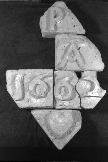 Figure 28. Page's cartouche.
construct a house without hiring a mason to do the ornamental parts. This resulted in the increased use of brick in England (Summerson 1953).
Figure 28. Page's cartouche.
construct a house without hiring a mason to do the ornamental parts. This resulted in the increased use of brick in England (Summerson 1953).
The Page house employed a common two-room floor plan that featured a large hall, entered into from the porch tower, and a smaller parlor/chamber that was entered from the hall. The hall served as a multipurpose room where a variety of everyday activities took place. The parlor, on the other hand, was a more private room where the owners usually slept and displayed their more valuable items. It is also where important visitors would have been entertained. The top floor would have served as sleeping quarters, most likely for children, servants, or slaves. Below the first floor was a full basement (Fig. 29).
The house interior shows that Page's desire for elaborate ornamentation was not relegated to the exterior. Large amounts of plaster from the upper floors indicate that both first-floor rooms were plastered. The detail Page put into the rest of his house was also apparent in the cellar, which contained four unheated rooms: one under each tower and two in the main section. The absence of hearths in the cellar implies that cooking activities took place elsewhere. The foundation walls were principally laid in Flemish bond, characterized by the use of alternating headers and stretchers in the same row, and all the mortar joints between the bricks were scored or "struck" to give the walls a finished look. Most cellars in Virginia were neither laid in Flemish bond nor finished. Only one other seventeenth-century house, Arlington in North-Hampton County, and two eighteenth-century houses, Battersea and Belle Grove in King George County, are known to have had struck Flemish bond brickwork in their cellars (Edward Chappell 1996, personal communication). Square ceramic paving tiles were used to floor both towers, and in the main part of the cellar a very elaborate contoured brick floor was employed that incorporated bricks placed on their sides with ones that were laid flat. This design performed two main functions. First, the contoured floor served to keep items stored in the cellar dry by funneling water into sumps. Keeping cellars dry in colonial Tidewater required both ingenuity and effort. Second, portions of the floor, adjacent to the foundation wall, also served as a low shelf, designed to keep things dry when water did find its way into the cellar. The craftsmanship used in constructing the cellar and the elaborate design demonstrate that Page was concerned with making both the public and nonpublic areas of his house sophisticated.
Cellars are normally used for storage, but in seventeenth-century England these spaces 58 sometimes served other functions. Among the stored items, which usually included various alcoholic beverages, men occasionally gathered to drink. Those who could afford it took great care in the appearance and layout of their cellars. In his diaries, Samuel Pepys mentions occasions where he and others withdrew to the cellar to drink. According to his accounts, an acquaintance "took us into the cellar, where we drank most admirable drink, a health to the King. Here I played on my flageolette, there being an excellent echo,"(Pepys, in Ruggles-Brise 1949:28) . Another entry in March 1663 states:
… we found My Lord with Colonel Strangways and Sir Richard Floyd, Parliamentmen, in the cellar drinking, where we sat with them… (Pepys, in Ruggles-Brise 1949:28)
This practice seems to have continued into the eighteenth century. A painting by William Hogarth circa 1740 entitled "Charity in the Cellar" depicts five men drinking there. By establishing such an ornate space, Page was no doubt trying to create a cellar appropriate for a prominent English gentleman. It is unclear, whether consuming drink in the cellar was a common practice in Virginia, but his elaborate English basement 59 would have been an ideal place to entertain his peers in such a fashion.
There were two ways to enter the cellar: through an outside entrance known as a cellar cap (Fig. 30) that was located on the back of the house and featured brick steps with wooden nosings, or by descending a wooden staircase in the stair tower located at the back of the house. Evidence for a staircase on the right side of the tower comes from two holes chopped in the northern wall for framing and a small hole in the tile floor that supported a newel post around which the stairs wound (Fig. 31). The cellar rooms beneath the towers were separated from the rest of the cellar by wooden partition walls, with the porch tower wall later being encased in brick. Entry into the main part of the cellar would have been through wooden doors.
Abutting the western wall of the stair tower was a rectangular area of brick incorporated into the tile floor. This feature aligned with two vertical mortar streaks on that wall suggesting that something associated with the bricks was attached to the wall. On the eastern end of the feature, two small posts that appear to have been connected by a board might have formed part of a barrier (Fig. 32). No artifacts associated with this feature were found, thus the function of this 60 area remains unclear. In the main part of the cellar a narrow trench was discovered that housed a wooden partition wall separating the area into two rooms, a large northern room that measured 18' by 21' 8" and a smaller one to the south that measured 12' 3" by 18'. Three piers were discovered in these rooms. Two were incorporated into the middle of the northern and southern foundation walls, respectively, and one was freestanding in the small room (Fig. 33). These piers would have held a summer beam used for structural support. There may have been a fourth pier in the larger room, but a 3' wide modern pipe trench that cut through the cellar would have removed all evidence of it (Fig. 34). Regardless, no freestanding pier in the large room was located on the same alignment as the pier in the small room. This was no doubt due to the location of an outside entrance in that area. A freestanding pier placed at this location would have interfered with the transport of items in and out of the cellar.
As one might expect with a finished cellar in the Tidewater, keeping it dry was a concern.
Each of the four rooms was fitted with its own drainage sump. The tower
61
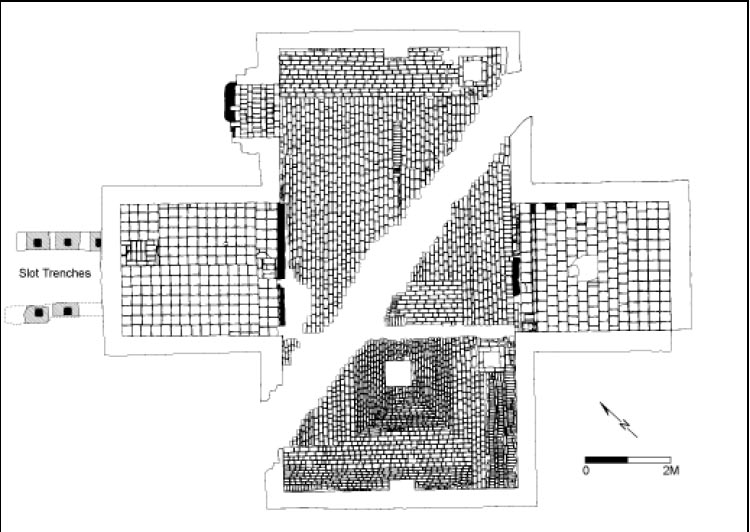 Figure 29. Plan view of Page house cellar.
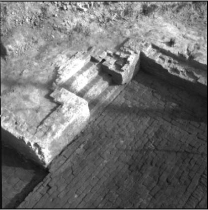 Figure 30. Outside entrance into cellar.
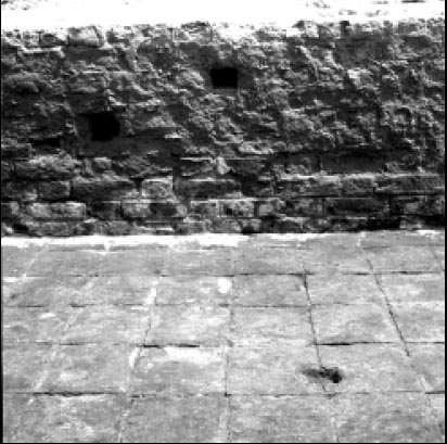 Figure 31. Newel post and framing support holes for stairs.
sumps were shallow and were brick lined, while the two in the main section were deeper with unlined bottoms. Each room appears to have had
different drainage needs (Fig. 35). In the porch tower, concave tiles drained water into a sump. The stair tower, on the other hand, contained no drainage tiles and only a small sump. Since not much was stored in that room, swift drainage was unnecessary. The
contoured floors in the main part of the cellar were geared towards quickly funneling water along a specific
62
Figure 31. Newel post and framing support holes for stairs.
sumps were shallow and were brick lined, while the two in the main section were deeper with unlined bottoms. Each room appears to have had
different drainage needs (Fig. 35). In the porch tower, concave tiles drained water into a sump. The stair tower, on the other hand, contained no drainage tiles and only a small sump. Since not much was stored in that room, swift drainage was unnecessary. The
contoured floors in the main part of the cellar were geared towards quickly funneling water along a specific
62
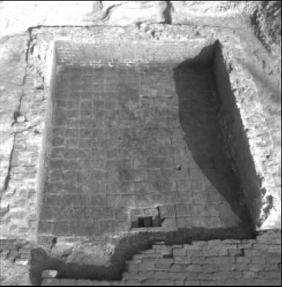 Figure 32. Stair tower.
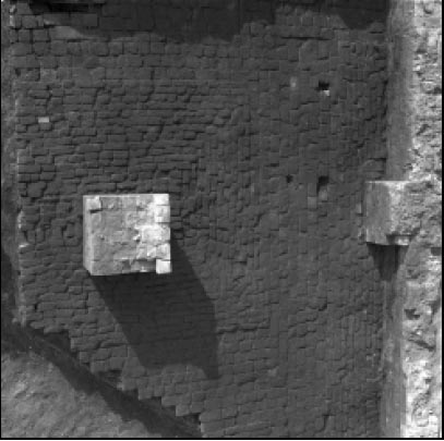 Figure 33. Summer beam supports.
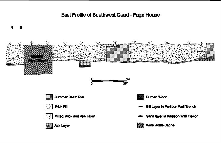 Figure 34. Cross-section of Page cellar.
route towards the sumps. Because these rooms would have been primary storage areas, rapid drainage was very important.
Figure 34. Cross-section of Page cellar.
route towards the sumps. Because these rooms would have been primary storage areas, rapid drainage was very important.
Underneath the brick floor in the main part of the cellar was a thin surface made up of brick bits and burned clay. This surface was built on the same level as both tile floors, suggesting it may have been an earlier floor that was replaced, possibly due to poor drainage or even fire. It is also possible that this surface was a base laid down to create the contours of the floor.
The fact that Page and a good number of his contemporaries built in brick at a time when most people constructed wooden post-in-
ground structures can be seen as an
63
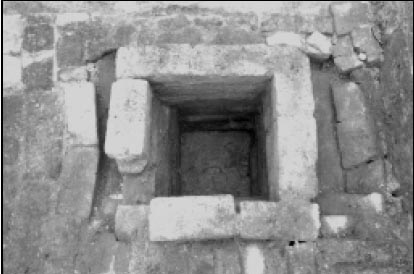 Figure 35. Drainage sump.
attempt to change Virginia from a fragile foothold to a settlement that mirrored English society as much as possible (Billings 1975; Pickett 1996). The increase of brick buildings in England during the seventeenth century was prompted by the lack of timber, new fire laws, and the fashionable nature of brick. In Virginia the situation was quite different. The lack of stone, the abundance of wood, and the monetary commitment of tobacco all meant that most colonists did not have the need or capital to build more substantial brick homes. It is also possible that men arriving in Virginia in the seventeenth century recognized that they might not live for many years. Impermanent, earthfast
dwellings might have been a reflection of the new colonists' belief that their life expectancy in Virginia was short and that legacies to children were uncertain due to vagaries of remarriage. Post-in-ground structures were still the dominant form of housing in seventeenth-century Virginia and were used by the upper classes until they felt a need to separate themselves from the rest of society. Although brick construction was more common in Middle Plantation, the unique and elaborate character of Page's house was an exception in the harsh and sometimes dangerous world of seventeenth-century Virginia. The uncertainty of life and the unstable environment that was reflected in housing was being defied by men like Page who, by introducing brick structures into their landscape, wanted to recreate a more familiar and stable world.
Figure 35. Drainage sump.
attempt to change Virginia from a fragile foothold to a settlement that mirrored English society as much as possible (Billings 1975; Pickett 1996). The increase of brick buildings in England during the seventeenth century was prompted by the lack of timber, new fire laws, and the fashionable nature of brick. In Virginia the situation was quite different. The lack of stone, the abundance of wood, and the monetary commitment of tobacco all meant that most colonists did not have the need or capital to build more substantial brick homes. It is also possible that men arriving in Virginia in the seventeenth century recognized that they might not live for many years. Impermanent, earthfast
dwellings might have been a reflection of the new colonists' belief that their life expectancy in Virginia was short and that legacies to children were uncertain due to vagaries of remarriage. Post-in-ground structures were still the dominant form of housing in seventeenth-century Virginia and were used by the upper classes until they felt a need to separate themselves from the rest of society. Although brick construction was more common in Middle Plantation, the unique and elaborate character of Page's house was an exception in the harsh and sometimes dangerous world of seventeenth-century Virginia. The uncertainty of life and the unstable environment that was reflected in housing was being defied by men like Page who, by introducing brick structures into their landscape, wanted to recreate a more familiar and stable world.
John Page's Heart Cartouche: An Interpretation

The cartouche found in 1995 displays in raised, carved forms the initials P and A, the date 1662, and a heart. The interpretation of the initials and date is simple: the date indicates the year Page constructed the house; the P stands for Page and the A stands for Alice, the name of Page's wife. (The initial for Page's first name was never found.) It is likely that the heart is a religious icon representing Page's piety.
Today the heart symbol carries connotations of romantic love. During John Page's century, however, the heart had a very different meaning. As early as the Middle Ages, the heart motif represented religious devotion. In European art and architecture, the image frequently was used as a decorative motif in cathedrals or a symbolic representation in painting for divine love. Martin Luther and John Calvin both used hearts in their personal seals. In its broadest connotation the heart represented centricity, since the heart was considered the center of the human body. This centricity was likened to God's love for man. Moreover, the heart was considered the center of human reasoning and emotion (Schaffner and Klein 1984:8-10; Apostolos-Cappadona 1994:156; Chevalier and Gheerbrant 1969: 479).
The heart on the Page cartouche was likely a religious symbol attesting to Page's own piety and perhaps to his concept of what it meant to be a colonist in seventeenth-century Virginia. Like most individuals of the seventeenth century, Page was a devout man, even as he also hoped to reap the material rewards that his plantations in Virginia might bring him. Just as the New England Puritans brought religious expectations with them to North America, so too did the Virginia settlers. Differences in theology and in experiences in England and the colonies certainly shaped the direction of regional religious beliefs, but as Darrett Rutman argues, Virginians no less than their Puritan neighbors would have sought some way to "bridge the transcendent," to organize their world around the idea that something lay beyond the material confines of their present (Rutman 1978).
Evidence of Page's religious sentiment is abundant. Page served as a member of the vestry for his parish. He was a driving force in the building of the first brick church at Bruton Parish, which was built close to Page's Middle Plantation home on land that formerly belonged to him. A 1678 document in the York County records refers to Page as a minister, but he was primarily a planter, merchant, and entrepreneur (YCR, DOW 6:4). Even in his will, he displayed pious concerns. While seventeenth-century wills routinely included introductory religious remarks, Page's comments seem more than merely formulaic:
I surrender my soule into ye hands of God, my Creator, considering that my body being raised from nothing to what itt is now, is a mutation noe lesse than infinite; steadfastly believing after this mortall life ended, that by ye Divine power of God & merrit of my Saviour, Jesus Christ, ye resurrection of my body and everlasting life, my body I remitt to ye Earth, to be decently buryed, with Christian buriall according to ye reights & ceremonies of ye Church of England,"(YCR, 9:103-104).
Nowhere is John Page's religious devotion more clearly laid out than in the Deed of Gift, a 1687 tract that was seemingly written by Page as a spiritual and secular guide for his younger son Matthew. The tract, an elaborate discussion of piety and salvation, was published in 1856 by Bishop William Meade after having been passed around by various Page descendants since the end of the Revolutionary War. The eighteenth-century history of the document was recounted by Matthew Page's great grandson, Governor John Page of Rosewell, in a letter printed at the front of the published volume. According to the governor, the original manuscript (along with another written by the first John Page) was given by his father to President William Stith of the College of William and Mary. After Stith's death it fell into the hands of Commissary Robert Dawson. Page wrote: "I saw them in his library in 1757, and knew them to be the books I had seen in my father's closet; and which I knew he had given to Mr. Stith to be published, should he think proper." After Dawson's death these two manuscripts disappeared for nearly twenty years. In 1776, they were brought to the Governor by a Mrs. Hay on behalf of her brother, Matthew Davenport. Mrs. Hay told the Governor that the manuscript had been found in the Geddy shop in Williamsburg. By the 1850s, Bishop Meade was in possession of the manuscript and he arranged to have it published in 1856 (Meade 1856).
After its publication, the manuscript once more was lost. Richard Channing Moore Page in his genealogy of the Page family expressed his certainty that the document was returned by the Philadelphia publisher to the Page family, but he could give no definitive location for the manuscript. "It is highly probable," he wrote in 1893, "that the original MS. is now in possession of the family of Capt. Thomas Jefferson Page, U.S.N., now residing in Florence, Italy." The Department of Archaeological Research inquired repeatedly about the fate of the manuscript without results.
The problem with the document's questionable provenance is amplified by the tone of the published Deed of Gift. The writing in the document contrasts sharply with Page's tone and syntax in his will. Without confirmation of the existence of the original Deed of Gift, the document must be treated with some skepticism. It is possible that the document that Bishop Meade published was not as old as it was purported to be or that it was heavily edited before its publication. Despite the problems with its origins and its tone, the document bears one passage that is well worth considering in light of the archaeological investigations.
The Deed of Gift is a long tract on the subject of salvation. In it the author discusses the role of the heart in the secular and religious life of man. "All the faculties of man follow the heart, as servants the mistress" So the heart leads, directs, moves the parts of the body and powers of the soul "and the mouth speaketh, hand worketh, eye looketh"(Meade 1856:40) . Page brings together both the notion of the heart as symbol of centricity in its broadest sense and the idea of the heart as a core religious symbol. God placed the heart "in the midst of the body, as a general in the midst of his army"(Meade 1856: 40) . He also wrote that if "your body be the temple of God, sure your heart is the holy of holies"(Meade 1856: 39) .
The religious imagery of Page's writing is clear. The heart is the center of God's relationship with man. But as an image of centricity, the image of the heart on Page's house speaks to his concepts of what it meant to live in Virginia in 1662. The heart that adorned the front of that house almost certainly represented the Middle Plantation structure as the physical center of Page's world. That seventeenth-century Virginians would have considered the heart a symbol of centricity is evidenced by the language in the 1676 petition by York County residents to move the capital of Virginia to from Jamestown to Middle Plantation. They justified their request by describing Middle Plantation as the "very Heart and Center of the Country"(quoted in Goodwin 1940) .
At a time when mortality was high, when families were constantly being broken up by the death of parents and children, and when men put their capital into the short-term goals of profits from tobacco, the house with the heart at Middle Plantation suggest a more permanent conception about life in Virginia. Page evidently meant to stay in Virginia and prosper, to make Virginia the center of his world rather than an extension of it. Page constructed a brick house at a time when most men built far less permanent buildings. His house, no doubt built at considerable expense, was not the home of an individual overwhelmed by the uncertainty of life in the harsh climate of Virginia. In his religious convictions and his architecture, Page belies the traditional picture of seventeenth-century Virginia and suggests a commitment to and investment in Virginia that historians have traditionally seen as occurring nearly a quarter of century after Page built his house at Middle Plantation (Morgan 1976; Carson et al. 1977).
The Outbuilding
While the manor house may have been the focal point of the plantation, it was but part of a greater whole. The home existed as the center of a larger domestic landscape that served as a working environment adapted to the particular needs of the household (Miller 1994:66). The domestic landscape that evolved in the Chesapeake frequently included outbuildings or dependencies to the main structure. Domestic outbuildings found on seventeenth-century plantations in the Chesapeake include servants' quarters, kitchens, and dairies/butteries (Keeler 1978:79). Other outbuildings include barns, malthouses, stables, and animal shelters. Beginning in the seventeenth century, the increase in the number of outbuildings on plantations reflected greater functional specialization (Linebaugh 1995). In many respects, the segmentation in architecture and landscape during the late seventeenth century reflected the increased segmentation within Virginia society at large.
Given the evidence for growing diversification on the Page plantation, a number of structures were probably built to fulfill a variety of functions (Fig. 36). At least seven structures are historically documented. While most of these are referred to generically as old houses, a term that could mean anything from a storehouse to a dwelling house, the reference to the destruction of a bread oven in 1705 indicates that some of these were built to perform specific functions (Journal of the House of Burgesses n.d., 4: 55,69). The will of Francis Page dated 1692 also lists a "Mault house" and two brick barns.
64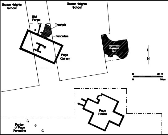 Figure 36. Page outbuilding.
The remains of a second brick structure were identified approximately fifty feet northwest of the Page house at Bruton Heights (Fig. 37). The building was discovered in June 1995 by construction workers trenching along the foundation of the southeastern wing of the extant school building. Shortly thereafter, the entire western end of the building was discovered beneath the floor of an adjacent wing of the school building. The alley between these wings was mechanically stripped in December 1995 to expose all but the eastern wall of the structure. The evidence revealed during this investigation shows that John Page lavished the same attention to architectural detail on support structures as he had on his manor house.
 Figure 37. Mapping of the kitchen/quarter.
The outbuilding (Fig. 38) was large by seventeenth-century standards, measuring approximately 50 feet long (east/west) by 30 feet (north/south). Excavation uncovered brick foundations that were 1½ bricks wide. Unlike the main house, this building lacked a cellar. Instead, the builder dug trenches averaging one foot in depth to lay secure foundations for the structure. The excavation of
65
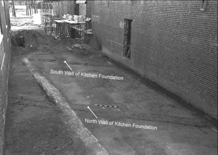 Figure 38. Overview of kitchen/quarter. The foundation walls run diagonally left to right;
the light stain running top to bottom is a modern concrete foundation.
these trenches revealed that the foundation, executed in English bond, extended at least four courses beneath the ground surface. Given the width and the depth of the foundations, the structure may have stood one-and-a-half stories. Water table brick, used roofing tiles, and window leads recovered from a trashpit on the northern side of the building indicate that, like the manor house, this building was built entirely of brick, had
casement windows, and possessed a tile roof.
Figure 38. Overview of kitchen/quarter. The foundation walls run diagonally left to right;
the light stain running top to bottom is a modern concrete foundation.
these trenches revealed that the foundation, executed in English bond, extended at least four courses beneath the ground surface. Given the width and the depth of the foundations, the structure may have stood one-and-a-half stories. Water table brick, used roofing tiles, and window leads recovered from a trashpit on the northern side of the building indicate that, like the manor house, this building was built entirely of brick, had
casement windows, and possessed a tile roof.
A total of one hundred sixty-six artifacts were recovered during the excavation of the builder's trenches. Not surprisingly, over half (58.6%) of this material was architectural in nature. Nails were most abundant with 52 fragments, followed by window glass, unused roofing tile, and unused brick. Undoubtedly this material represents construction waste. Four pieces of slag, a fragment of charcoal, and two iron pieces might also relate to the construction of this building.
Domestic artifacts were also recovered from the builder's trenches. These artifacts included a piece of bottle glass and a ceramic fragment as well as 24 pieces of animal bone, 14 tobacco pipe fragments, and a piece of flint. The presence of this much material in the builder's trench indicates that the building was constructed after the site had been occupied for a while. In other words, trenches for the foundations were dug through artifact bearing layers, and this material was redeposited when the builder's trenches were backfilled. Virtually all of this material was recovered from the southern side of the building facing the manor house, which suggests that the house constructed in 1662 preceded the kitchen. Although none of the artifacts retrieved from the builder's trenches was temporally diagnostic, one pipe bowl could be broadly dated to the period between 1650 and 1680 based on stylistic attributes. But if the kiln located two hundred 66 and twenty-six feet to the east provided brick and tile for all of the structures at Bruton Heights, then the kitchen must have been constructed no earlier than 1662 and no later than 1670, given the lifespan of the kiln.
The remains of an H-shaped hearth were also identified. The placement of the chimney suggests that the building was a two-bay structure with a lobby entrance. The western room measured 16 feet (east/west) by 18 feet (north/south) while the eastern room was at least 20 feet (east/west) by 18 feet (north/south). Oddly, the offset position of the chimney indicates that the lobby entrance was on the northern side of the building away from the manor house. It is possible that this entrance opened into a working yard hidden from the view of the main house. Moreover, this configuration might also indicate that the area immediately behind the house was a more formal space.
Little of the hearth remained due to the robbing of brick and subsequent impact through grading and trenching associated with the construction of the school. Despite this, the excavation revealed several important clues about the hearth's construction. A shallow builder's trench measuring approximately 2 feet across and 2 inches deep was dug and bricks were laid on a thin layer of shell mortar to provide a footing for the hearth. Enough brick remained within the trench to determine that two courses formed the back (northeast/southwest) wall. An arm of fragmentary brick extended over 3 feet to the east from the southern end of the hearth wall. Like the back wall, the southern arm consisted primarily of broken bits of brick and chunks of mortar, which suggested that the usable bricks had been robbed from the hearth following the demise of the structure. The remaining brick was still contained within a builder's trench measuring 1½ feet wide and less than 1 inch deep. A modern utility trench extending through the kitchen virtually obliterated the entire northern arm to the hearth. Enough of it remained however to determine that two courses of brick had survived in this area, evidence that an extra course of brick was needed to fill in a low spot and level the hearth.
Although no brick was identified on the western side of the hearth, a thin quarter-inch spread of shell mortar extending to the west from each end of the back wall suggests that the hearth was originally H-shaped to provide heat to both rooms. Moreover, the clay floor between the linear mortar spreads had a dry, flaky texture, suggesting that the soil in this area had been scorched. The clay floor on the eastern side of the hearth consisted of a scorched pattern of red, bright orange, and black ashy clays that extended as much as 1" deep in places. The extensive burning in this area reveals that the hearth was unpaved and that the fire was built directly upon the clay floor. Likewise, this evidence indicates that the floors throughout the building were packed clay. Only two wrought iron nails were recovered from the hearth-related features.
Several clues indicate the specific role that this outbuilding played within the Page plantation. The size and layout of the structure suggests that it served as a quarter for servants and/or slaves. Servant's quarters appear in Virginia in greater numbers after 1650. While the warm temperatures and the high humidity are frequently used to explain the removal of activities such as dairying to separate buildings within the Chesapeake homelot, a trend favoring greater privacy and segmentation within society may explain why quarters appeared on Virginia plantations by the mid seventeenth century (Neiman 1993; Linebaugh 1995). Moreover, many early outbuildings served as multipurpose buildings that fulfilled a variety of functions. The outbuilding identified at Bruton 67 Heights appears to have served a dual capacity as a workhouse and quarter. While the building was large enough to house servants and slaves, artifacts recovered from a trashpit located along the northern wall of the building indicates that it also served as a detached kitchen for the main house. While this feature produced the coarsewares and stonewares typically associated with food storage and preparation, more refined tablewares including porcelain and leaded tableglass were also recovered.
The Changing Landscape
While the manor house would have been the most visible feature on the Page property, it was but one component of a larger plantation system. The archaeological investigations conducted on the Bruton Heights property between 1989 and 1995 revealed a complex plantation landscape shaped by Page and his successors between 1662 and 1730. The Page landscape appears to have taken its shape in the years immediately following the construction of the manor house. Moreover, the evidence suggests that this landscape remained dynamic for nearly sixty years. Throughout the second half of the seventeenth century, buildings appeared, fences were moved, and different elements came and went. Despite the fact that much of the Page landscape lies obscured beneath school structures built in the 1940s, the various landscape features identified during the investigation shed light into how this early colonial plantation functioned as an integrated whole.
Testing revealed that most of the features comprising the Page plantation were arranged along the northern side of the manor house, extending the length of the terrace toward the northwest. This pattern, known as the L-shaped farmstead, became popular in England during the seventeenth century. The L-type layout developed out of the linear farmstead where the agricultural buildings were lined up behind the house while a yard was maintained in front. The L-shaped farmstead probably created a more protected farmyard (Harvey 1984:48). The L-type pattern, in turn, gave way to fully developed courtyards where parallel ranges of buildings enclosed the farmyard on three or four sides. Nigel Harvey argues that the evolution of the English farmyard was motivated by agricultural diversification (Harvey 1984:48). Thus it seems that John Page looked to an English precedent for more than just his architecture.
The archaeological evidence suggests that the Page landscape was initially a linear layout. Shortly after the construction of the house in 1662, fences were established on both sides of the house enclosing a yard behind the house. Eight postholes comprising a fence on a northwest/southeast axis were identified thirty feet south of the manor house. There was a 6 foot interval between the posts in this line and each posthole had postmolds averaging 6 inches square. Although only seven nails were recovered from the four postholes that were excavated, this fenceline is assumed to be early due to the paucity of artifacts. Three posts that pre-date the kitchen appear to represent the corresponding fence along the northern side of the house. The postholes in this line were placed at a 5 foot interval and along a northwest/southeast axis. Like the postholes of the southern fenceline, the posts of the northern line produced few artifacts. A combined total of one bone and nine nails was removed from these features. The western posthole in this line provided the only evidence for a postmold among these features. This mold measured 6 inches north/south by 4 inches east/west. If extended, this line would pass thirty feet from the northern side of the house like the parallel line to the south.
68Page retained the yard behind the house following the construction of the kitchen in the late 1660s. The remains of two other fences were also identified within ten feet of the earlier fence that passed along the southern side of the house. Due to extensive modern disturbances in this area, only four holes could be associated with each of these features. Despite this, they reflect the same northwest/ southeast orientation as the house and the other fencelines. Given the close proximity of the three fencelines to one another, they appear to represent a single boundary line that was maintained over an extended period of time. As one fence deteriorated, another was constructed to take its place.
The kitchen was constructed where the fence passed along the northern side of the manor house. Two of the postholes in the northern line contained more than one fill deposit, which suggests that they were purposely removed to make way for the outbuilding, with the second filling episode dating to the time the posts were removed. Like the earlier fence, the kitchen was oriented along a northwest/southeast axis. The architectural evidence indicates that the dependency opened onto a workyard on the northern side of the building, away from the manor house. The yard was enclosed by a slot fence to the west of the door and contained a trashpit. The slot trench extended approximately ten feet northeast of the kitchen and 69 measured 1 foot wide and 4 inches deep. It contained only a single bone fragment and extended beyond the project area to the north. The trashpit located east of the entrance to the outbuilding measured at least 15 feet north/south by at least 10 feet east/west but extended beyond the project area to the north and under the building to the east. The artifacts recovered from this feature indicate that it was gradually filled between 1680 and 1715. By placing the entrance and the workyard on the northern side of the dependency, John Page may have intended to place work areas out of view in order to create a more formal courtyard in the enclosed space behind the manor house.
Placing the kitchen along the northern side of the house resulted in an L-type layout for the plantation. The identification of a borrow pit to the east of the kitchen as well as several fences in the vicinity of the kiln site suggests that the L-shaped layout was maintained over time. A fence was erected to delineate boundaries in the field east of the house after the kiln was demolished. Eighteen holes set at 9 foot intervals were identified extending across the field on an axis 10° east of north. The holes averaged 2 by 2 feet and 1½ feet deep. Two of the holes had postmolds measuring 4 by 4 inches while five others showed evidence of post removal. Artifacts recovered from the fence line generally reflected the proximity of this feature to the earlier kiln-related features. They consisted primarily of brick, roofing tile, and a paving tile. Very few cultural artifacts were 70 recovered from the postholes. Despite the absence of temporally diagnostic artifacts, this post and rail fence has to post-date the kiln because one of its fence holes cuts the abandoned irrigation trench that had been backfilled after the kiln activity ceased.
A shallow trench extended 90° to the east from the fourth hole on the southern end of the post and rail fence. The trench was 48 feet long, 15 inches wide, and 6 inches deep. Although this ditch may have originally been excavated as a drainage ditch, its orientation and direct relationship to the post and rail fence suggests that it represents a ditch-set or slot fence that was constructed to enclose a small garden or other activity area, protecting it from "wind and wildlife"(Patrick 1983:10). This type of fence was built mainly during the seventeenth century, and examples of slot fences enclosing domestic yards during the seventeenth century have been identified at Kingsmill (Kelso 1984), Carter's Grove (Edwards 1994), and at Clifts Plantation (Neiman 1978). William Fitzhugh provides a contemporary account of his property, which in 1686 had:
…a Yeard wherein is most of the aforesaid necessary houses, pallizado'd in with locust Puncheons, which is as good as if it were walled in & more lasting than any of our bricks …(Fitzhugh, in Patrick 1983:10).
Posts were often added as an extra means of support for the backfilled ditch, although there was no evidence for this at Bruton Heights. An account of an enclosed garden in Maryland dating to 1796 describes a fence constructed of "197 punches" that appears to have been "supported entirely by the restriction of a backfilled slot"(Patrick 1983:11) .
Shallow ditches extended at right angles from both ends of the trench, indicating that the slot fence continued beyond the project area and possibly enclosed a domestic yard to the south. The ditch extension on the western end of fence stretched nearly 8 feet between a panel of the associated post and rail fence. The northern end of the feature abutted a posthole of the post and rail fence. This trench was 15 inches deep and filled with orange clay. A postmold discovered at the southern end of this feature measured 4 inches square and extended to the bottom of the trench. No artifacts were recovered from this feature, making it difficult to date. But its orientation with and relationship to the post and rail fence and the slot trench suggests it was related to these structures. This enigmatic trench may mark the location of a gate or be evidence of a repair to the fence.
Four substantial postholes were also identified west of the post structure identified near the kiln. The posts, set at 8 foot intervals, were on the same axis as the northern series of posts in the structure. Despite their large size, the posts probably represent a portion of a fence. The posts measured just over 2 feet on a side and averaged 1½ feet deep, while the base elevations all fell within a 2 inch range. The placement of these posts on the same axis as those comprising the northern wall of the post structure may indicate that a fence continued up to the corner of this building. Moreover, at least two of the posts had been repaired, so this fence had been maintained and repaired over an extended period of time.
The postholes comprising this fence differed from the earlier features associated with the kiln in that they contained a great deal of domestic refuse. Ceramics, bone, tobacco pipes, table glass, and three hundred seventy-one pieces of wine bottle suggest that activity southwest of the kiln increased dramatically between the time the kiln began operation and the time that this fence was erected. The predominance of domestic material suggests that this boundary 71 feature postdates the kiln and represents the occupation of the house instead.
Architectural material was also abundant. One hundred ninety-nine roofing tiles were recovered from the postholes and molds. Roofing tile and brick fragments were even used to shore up the bottom of posts in two of the holes. Other industrial and architectural debris included slag, nails, nearly two hundred pieces of window glass, and twenty window leads. The concentration of artifacts in the features increased toward the house to the southwest. The large amount of brick, nails, window leads and glass, and unused roofing tile suggest that the assemblage recovered from the postholes of this fenceline might be refuse from the construction or renovation of the Page home. Although most of the material from the postholes is temporally undiagnostic, window leads marked 1669 indicate that the debris was deposited during the 1670s. Window leads found in North America typically have a lag-time of five to seven years. Moreover, the analysis of leads from several sites in St. Mary's City, Maryland, demonstrated that dated leads could often be linked directly to episodes of construction and renovation (Hanna 1992, 1993:37). While the window leads recovered from the postholes at the western end of the Bruton Heights kiln site were dated 1669, a five to seven year lag-time might actually represent the construction, destruction, or renovation of a building sometime between 1674 and 1676. As such, the leads from Bruton Heights could relate to repairs made on the Page plantation following Bacon's Rebellion in 1676. The fact that John Page filed a claim for losses after the rebellion demonstrates that troops under Nathaniel Bacon plundered the estate of John Page in 1676.
Bacon's Rebellion
John Page's rise to colony-wide eminence occurred over a period of several decades. At the time of Bacon's Rebellion Page's status was ambiguous. In many ways he appeared to be among the leading men of the colony, yet in the mid-1670s, he was not a man in the inner circle of colonial power. Unlike his Middle Plantation neighbors Thomas Bray and Thomas and Philip Ludwell, Page had not been elevated to the elite circle of the Green Spring Faction. Instead, in these years, Page is best identified as perhaps the most prominent man in York County, a local rather than regional leader.
Despite Page's tenuous hold on colony-wide prestige, Nathaniel Bacon clearly regarded him as one of the leaders of the colony. In the course of the rebellion Bacon kidnapped several of the "prime mens wives" and fled with them to Jamestown. John Page's wife, Alice, was one that Bacon selected for this questionable honor. Bacon was "was no sooner arrived at Towne," according to one account:
but by several small partyes of Horse "he fetcheth into his little Leagure, all the prime mens wives, whose Husbands were with the Governour," which the next morning he presents to the view of there husbands and ffriends in towne, upon the top of the smalle worke hee had cast up in the night, where he caused them to tarey till hee had finished his defence against his enemies shott, it being the onely place "for those in towne to make a sally at "(Cotton 1676).
As one of the "prime men" of the colony, John Page was also included in Nathaniel Bacon's scathing denunciation of Berkeley and his councilors. In the "Declaration of the People," Bacon called for Berkeley and his "pernitious Councellors" to surrender themselves to him. Bacon claimed that through many specific acts these men had sought only to enrich themselves while letting the rest of Virginia suffer without adequate towns, promotion of trade, and protection from the Indians (Bacon 1676).
At first, John Page was one of the men in Middle Plantation who signed an oath supporting Bacon. In August 1676, along with many other militia heads of the counties and gentlemen planters, Page agreed to support Bacon should Berkeley send troops against him. The colonial leaders joined Bacon because they feared that the colony was disintegrating into civil war, a condition which Berkeley seemed unable to prevent. Page and his countrymen felt it better to join Bacon than be at the mercy of the displaced rabble who made up his chief supporters (Morgan 1975:266-67). At the end of Bacon's Rebellion, Page attached his name to another petition, this one a humble supplication for pardon from the governor who had ultimately prevailed. "To the Rt honble Sr William Berkeley Knt Governor & Capt Genrall of Virginia," the petition began:
Wee who lately were reputed his Maties Justices for Yorke County doe humbly conceive that it may not be allowable in us to act as justices either in Court of County untill such time as yor Honor shall indempnifie us or any of us by name for administering the oath Nathaniell Bacon Junior imposed on the people humbly referring to yor Honor to declare who shall be justices of the peace for the sd County Feb the 17th 1676/7 (YCR, DOW 6: 9).
Berkeley gave his pardon to Page and most of the others; Page's career seemed little affected by his actions during the rebellion. His willingness to sign Bacon's oath in the summer of 1676 did not prevent him from suffering at the hands of the rebels, however. In a list of "worthy persons" who were injured during the rebellion, John Page was deemed a "Great Looser" in his estate (C.O. 5/1371, ff. 171-78).
In the final decades of the seventeenth century, John Page and his son became increasingly important in the affairs of the colony. With his appointment to the Council in 1680, John Page moved beyond regional leadership into the upper echelons of colonial government. From 1680 to his death in 1692, Page was among the few most powerful political figures in Virginia. Francis Page also began to take a prominent role in colonial leadership. As the eldest son of a wellborn elite Virginian, the younger Page found the route to local and later regional leadership to be open and easy. As his father had, he rose to prominence first within his own county. In 1680, just two years after reaching legal age, he became a justice for York County. During the following decade he served as sheriff for York County, as a churchwarden of Bruton Parish, and as the county coroner (YCR, DOW 6: 207, 209, 394, 409; McCabe 1856). His rise to regional eminence, however, began with his appointment by Governor Effingham to the position of Clerk of the House of Burgesses in 1688 (Palmer 1875: 20).
The Page Artifacts
Virtually all of the artifacts dating to the Page period of occupation (1662-1693) were recovered from a borrow pit located thirty feet north of the house, from the trashpit located along the northern wall of the dependency, and from a redeposited midden layer found in a ravine just north of the house. While the borrow pit and the trashpit both saw continuous use throughout the last quarter of the seventeenth century and into the eighteenth century, the artifacts recovered from the borrow pit appear to reflect the third and fourth quarters of the seventeenth century while the artifacts recovered from the trashpit span only the fourth quarter of the seventeenth century.
The borrow pit appears to have provided clay for the manufacture of brick and tile during the early 1660s. It remained open following the completion of brick and tile making and was gradually filled in over the next forty years or so. Construction activities associated with the conversion of the school into an educational campus made it impossible to expose the feature entirely. Instead, two areas were sampled. The major excavation centered in an area scheduled to be impacted by school construction activities. Excavation of the feature in this area revealed several distinct layers within the pit extending to a depth of nearly 4 feet. The uppermost surviving layer was characterized by charcoal and ash.
The earliest context identified within the feature is a silt layer covering the bottom of the pit. Three hundred eight artifacts were recovered from this layer. Bone was the most abundant artifact type (60%) with one hundred sixty-eight pieces of faunal bone and eighteen shell fragments. Kitchen-related material represented nineteen percent of the 72 material recovered from this layer with fifty-seven artifacts. They included Portuguese tin-enameled ware (9 fragments), coarse earthenware (8), clear and colored table glass (4), wine bottle fragments (4), and case bottle fragments (32). Architectural artifacts were also recovered, included two pieces of roofing tile and one paving tile. Other artifacts of interest include a copper-alloy book plate, a wooden toy quoit, a mortising ax, and a polling ax. The high percentage of early artifact types such as Portuguese tin-enameled ware and case bottle glass suggests that this is the among the earliest Page-period contexts identified at Bruton Heights dating either to the operation of the kiln or to the early occupation of the house.
The upper, more recent layer is ash and charcoal containing over two thousand artifacts. The material in this layer dates to the fourth quarter of the seventeenth century; several of the recovered items indicate that this layer represents destruction debris dating to the time of Bacon's Rebellion. Faunal artifacts account for over half of the material recovered from this layer with one thousand twenty pieces of bone, fifty-seven shell fragments, and two egg shells. Architectural debris was also well represented (657 pieces) with window leads (12), window glass (217), roofing tile (125), and wrought iron nails (284) found in this layer. Ninety-five kitchen-related artifacts were found, including seventy-six pieces of ceramic and nineteen fragments of glass. Locally manufactured earthenware from the Challis site (14) and Venetian glassware (5) were among the more unusual kitchen-related items. Three copper-alloy upholstery tacks probably came from furnishings on the Page site, while a linen 74 smoother, sixty-one barrel hoops fragments, and an ax may have been used in the daily activities on the plantation.
Although most of the artifacts recovered from the upper layer of the borrow pit relate to the domestic life of a colonial plantation, several items could represent military activity that could be associated with Bacon's Rebellion or with the quartering of British troops in Middle Plantation shortly thereafter. Arms-related items recovered from this layer consist of a musket flint, a pistol flint, and a snaphaunce gun lock. A hand grenade was also identified within this context, as was a spur.
One of the most interesting finds was a complete shaft-and-globe wine bottle found near the bottom of the pit (Fig. 39). This 1650s bottle contained a seal bearing the name R. Billingsley, a Tudor rose, and a five-turreted castle. The seal may have belonged to Richard Billingsley, a tavern owner in Oxford, England. Billingsley's tavern opened around 1640 (Drumbrell 1983:237).
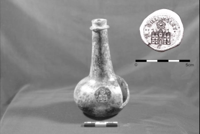 Figure 39. Billingsley bottle.
The trashpit located on the northern side of the outbuilding provided a material record of the later phase of occupation during the Page period. This phase probably began sometime around 1680 and continued until about 1715. The feature measured approximately 15' north/south by 10' east/west. A layer of brick and tile rubble covered the top of the feature. While this material could relate to the destruction of the outbuilding, it is more likely that it represents an effort to pave over the depression created by the trashpit after it fell out of use. Excavation revealed the pit to be a shallow bowl that extended to a depth of 4 feet. No layers were distinguished in the dark organic loam. Instead, pockets soil of varying colors and textures observed throughout the feature indicated that small amounts of material were dumped in periodically, filling the pit over a long period of time.
A total of two thousand eight hundred eighty-five artifacts were recovered from the trashpit representing ninety-five percent of 75 the material recovered during the excavation of the Page outbuilding. Moreover, the fact that eighty-three percent of the material (2406) found in this feature relates to foodways underscores the role of this structure as a detached kitchen. This assemblage includes a total of nine hundred ninety-seven (34.5%) kitchen-related artifacts and one thousand four hundred nine (48.8%) pieces of faunal material. Wine bottle glass was the most abundant kitchen-related artifact (541 fragments), followed by ceramics (331). The ceramics included two hundred thirteen pieces of delft and ten pieces of porcelain representing sixty-six percent of the recovered ceramics. Stonewares included eleven pieces of Fulham stoneware and a small white salt-glazed cup. Over thirty percent of the ceramics were coarsewares, including Iberian (29), Red Sandy ware (60), and colonoware (10). Less than 1% of the coarsewares could not be identified according to type. Unlike the Page house site, the assemblage recovered from the trashpit did not contain any ceramics produced in Yorktown. The absence of this ware type suggests that the kitchen fell out of use or was destroyed prior to 1725.
Surprisingly, one hundred six fragments of leaded table glass were also recovered from the trashpit. The most notable pieces of table glass include three wine glass stems and the graceful handle of a colorless leaded pitcher or ewer. The wine glass stems include a double-knopped stem dating to the late seventeenth century, a baluster stem dating between 1680 and 1690, as well as a Silesian stem with an elongated teardrop dating to circa 1715. Twenty-one pharmaceutical bottle fragments were also recovered.
Architectural debris represented the second most common artifact type. Two hundred ninety-nine nails and one spike were recovered, while ninety-one pieces of used roofing tile were found. Eight pieces of slate and seven pieces of shell mortar were also found. The presence of thirty-nine pieces of window glass indicates that finished windows were fitted on the outbuilding. Three window lead fragments are included in this assemblage. One of these is marked .EC.WM., part of the complete mark of .EC.WM.1669. observed on other leads excavated from Bruton Heights.
Fifty-three tobacco pipes were recovered. Forty-one of the tobacco pipes were imported, while only twelve were domestically produced. Only two of the pipes were marked or decorated. The bowl of an imported tobacco pipe was recovered bearing the heel marks of a B and a Tudor rose. The maker has not yet been identified. A complete decorated domestic pipe bowl was also recovered from the trashpit. It exhibited a sunburst design on the front of the bowl and a stylized tobacco plant design on the back, and has a rouletted stem.
A copper alloy pin was the only personal or clothing item recovered from the feature. Arms-related and furniture items were equally sparse. Arms-related artifacts included two pieces of flint and one lead shot. Furniture included a mirror fragment and the copper-alloy lid to a fuming pot, a container for simmering potpourri. Other items related to crafts and activities that would have been conducted in and around the dependency. Among these were charcoal (18), coal (5), and slag (4). Tools and equipment included a copper-alloy harness boss, a tire nail, a hoop, and an ax. Three flowerpot fragments were also found.
The Page Vessels
Usually time and money constraints force archaeologists to analyze assemblages using only the individual sherds found on a particular site. The limited nature of this level of analysis precludes determining the form and therefore the function of most pottery found on a site. Most sherds are simply too small to accurately determine their former vessel type. Occasionally an assemblage warrants a more complex and interesting analysis. This analysis, called a minimum vessel count, begins with putting the broken vessels back together. If enough pieces of an individual vessel can be put back together, its former form and function can be determined, resulting in a much richer analysis. The Page material warranted this extra attention. Artifacts from the ravine, the borrow pit, and the kitchen trashpit were combined to create a minimum vessel count.
At least 92 ceramic and table glass vessels were found. The vessels were used for a variety of functions, most relating to food preparation, storage, presentation, and consumption. Nonfood related activities that involved ceramics or glass included vessels used to prepare medicines or to remove human waste from the dwelling. Analysis of the Page vessels revealed both expected and unexpected results. The large numbers of tea-related and food-presentation vessels were not a surprise. A man of Page's station would be expected to employ fine ceramics and table glass at his table. Page's purchase of a matching set of porcelain teawares confirms his emulation of the latest fashions from England. Porcelain, first introduced to Virginia in the 1660s, was the centerpiece of the ritual behavior that accompanied tea drinking. Also found was a scent bottle, used to contain liquids that acted as perfumes. More of a surprise was the number of pharmaceutical vessels, in particular drug jars. Of the ninety-two vessels associated with John Page, thirteen were delft drug jars and two were pharmaceutical vials. In addition, over sixty drug jars were found in the house cellar, many of which contained stylistic attributes that suggest they were manufactured during the period Page lived at Middle Plantation. The large number of drug-related vessels suggests that Page took responsibility for at least some of the medical needs of his plantation.
Colonial diaries show that it was not uncommon for masters to administer to the medicinal needs of the plantation. For eighteenth-century masters this role was more than just an economic decision, it was part of the paternalistic milieu associated with being a gentleman and a slaveholder (Lockridge 1987). William Byrd of Westover plantation referred to both house and field slaves as "his family." He often visited the quarters of slaves threatened by disease and treated their ailments (Marambaud 1971). At nearby Sabine Hall, Landon Carter doctored not only his slaves, but his children, guests, and animals (Carter 1757). He used a variety of medicines including "rhubarb," "jalap," "cream tartar," and "ipecacuana" to, among other things, induce vomiting and reduce fever (Carter 1757).
Drug jars and glass pharmaceutical vials made up a large percentage of the Page period assemblage. The sheer number of drug-related items suggest that Page was doctoring his family and slaves. They also suggest that the responsibilities of being a gentleman and master had begun to manifest itself by the second half of the seventeenth century.
| Stoneware | Porcelain | Table Glass | Tin Enamelled | Coarseware | Total | Pct. | |
|---|---|---|---|---|---|---|---|
| Food Presentation/Tea | 1 | 7 | 1 | 1 | 1 | 11 | 12.0 |
| Food Consumption | 4 | 5 | 16 | 10 | 35 | 38.0 | |
| Food Storage | 4 | 6 | 10 | 10.9 | |||
| Food Preparation | 1 | 10 | 11 | 12.0 | |||
| Pharmaceutical/Toiletry | 3 | 17 | 5 | 25 | 27.2 | ||
| TOTAL | 9 | 7 | 9 | 35 | 32 | 92 | 100.0 |
| Coarsewares | Majolica | English Delft |
|---|---|---|
| Cup | Plate (2) | Drug jar (12) |
| Tankard | Drug jar | Chamber pot (4) |
| Pipkin | Plate (7) | |
| Bowl (4) | Colonoware | Porringer |
| Storage jar | Bowl | (9) Baker |
| Milk pan (14) | Hollow Form | Bowl (4) |
| Hollow form (3) | Twiffler | |
| Flowerpot (2) | Stoneware | Punch bowl |
| Jug | Porcelain | |
| Table Glass | Bottle | Saucer |
| Stemmed glass (4) | Tankard (2) | Cup (3) |
| Pitcher handle | Mug (2) | Punch bowl (2) |
| Pharmaceutical phial (2) | Storage jar (2) | Tea bowl |
| Scent bottle |
Artifacts and Status:
The Ravine Assemblage
The artifacts from Bruton Heights reflect the daily lives of John Page, his family, and his servants. A one percent sample of the ravine located northeast of the school building 76 produced over three thousand five hundred artifacts related to the Page period of occupation. The artifacts were deposited when the ravine was filled during the construction of the school in 1940. There is no question that this material came from the Page site. Window leads from the redeposited artifact assemblage match those recovered from the kiln site, the kitchen, and the dwelling. Likewise, analysis of roofing tiles from the secondary deposit show that they were produced in the kiln two hundred feet to the east. Two crossmends between the ravine and the kitchen site indicates that the material in the ravine originated primarily from the kitchen one hundred thirty-two feet to the southeast.
Clearly, this outbuilding was seriously impacted during the construction of the school, and the fill removed from the site was used 77 to fill the adjacent ravine. Despite the fact that these artifacts were removed from their original context, they still provide an invaluable material record of activities on the Page property. The artifacts shed light on such things as foodways, daily life, recreation, and the expression of wealth and status.
Most of the artifacts found in the ravine are architectural in nature. This is partly due to the fact that when the site was disturbed by the construction of the school, the architectural features that would normally remain in situ, such as brick walls, were dislodged and redeposited along with the other artifacts. The high percentage of architectural material may also be attributed to Page's passion for brick. Nearly two thousand three hundred (65%) artifacts were architecturally related. This includes some of the more common artifacts such as nails (892 fragments), brick, mortar, and window glass (575). Recovered roofing tile (678) and paving tile (8) indicate that the Page kitchen was just as substantially constructed as the manor house. Hinges and box-lock parts were also recovered. Forty-one window leads bearing the mark 8EC816698WM8 were found confirming that Page installed imported casement windows. Two fragments of plaster were discovered, including one that still showed evidence of an applied whitewash.
Artifacts also reflect the details of life. For example, three upholstery tacks suggests something about the furniture present on the Page site. Two of these tacks were copper alloy, which was typical for the period. The third was iron, however which indicates that the piece of furniture that it adorned may have been repaired or domestically produced. Two mirror fragments show that Page indulged in luxury items, while an iron buckle is a typical clothing item for the period. Two pieces of flint and eight fragments of casting lead waste are thought to be associated with weapons. Finally, a hoe discovered in the secondary fill may have been used 78 in the garden or to till tobacco. The hoe is stamped with an "NV" representing, perhaps, the maker's mark or that of the merchant who imported the item and sold it in Virginia (Egloff 1980). Unfortunately, the identity of "NV" remains a mystery.
Tobacco pipes are found on nearly every colonial site. Two hundred and four tobacco pipe fragments were included in the secondary deposit. Twenty-one of these were domestically produced. The pipes range from deep red to light buff in color reflecting the local clay from which they were produced. Pipe wasters discovered at Flowerdew Hundred add credence to the theory that domestic pipes were locally manufactured (Deetz 1993:69-70). Based upon their resemblance to English pipe forms, many domestic pipes appear to have been formed in a mold, while others appear to have been hand formed and decorated according to other influences. The domestically- produced tobacco pipe phenomenon appears during the 1640s and disappears in the first quarter of the eighteenth century. They are found throughout the Chesapeake east of the Fall Line (Deetz 1993:91-92). Unfortunately, the bores of locally manufactured pipes do not reflect the gradual and steady decrease in diameter found in imported pipes over time and thus 79 cannot be used to date sites. Domestic pipes are often elaborately decorated with inscribed, stamped, stippled, and rouletted designs. The archaeological evidence suggests that once applied, the designs were filled with clay, chalk, or lime to make them stand out against the earthen body of the pipe. Several decorated domestic pipes were found. One bowl fragment appears to mirror a contemporary English form and displays a rouletted rim over stamped dots. Another bowl fragment that appears less English in form shows evidence of hand stippled rows and bands. A rouletted and cross-hatched stem fragment is a design that is found throughout the region, which suggests local exchange. A large, single, intact bowl was also recovered from the ravine. It was burnished to give it a dull shine, and three rings were inscribed around the opening. Elaborate chevron-like designs suggesting a stylized tobacco leaf had also been etched down the front and back of the bowl. The bowl was packed with a mix of what appeared to ash and tobacco, an example of the excellent preservation within the ravine despite re-deposition. Domestically produced tobacco pipes account for only ten percent of the tobacco pipes found at Bruton Heights. The remaining ninety percent were imported.
Only one of the imported bowls recovered from the ravine was marked in any way. It was stamped with an "RT" on the front of the bowl. The mark is attributed to Robert Tippet II of Bristol, who produced pipes from 1678 until his death in 1713 (Hurry and Keeler 1991:52, 55; Walker 1977:1493-1494).
Six hundred and ninety-seven (32%) kitchen-related artifacts were found in the secondary deposit, including two hundred seventy-two ceramic fragments. The assemblage contained wares that were typical for the period. Coarsewares (62) were used for food preparation and storage. German and English stonewares (26) were used in table ware such as mugs and tankards as well as for utilitarian pieces such as jars and crocks.
Eight pieces of colonoware were recovered. Colonoware, a locally manufactured ceramic type that was originally attributed to Native American makers (Noìl Hume 1962), has a shell-tempered clay and burnished body resembling Woodland-period pottery. The presence of colonoware, 81 however, appears to correlate with the presence of slavery in the Chesapeake during the seventeenth and eighteenth centuries. Many scholars now believe that it was primarily made and used by enslaved African Americans (Deetz 1993). The appearance of colonoware after 1650 and continuing into the fourth quarter of the eighteenth century also corresponds to the growing separation of master and slave households.
The Page assemblage recovered from the ravine produced fine ceramics that would have been displayed in the home and placed on more fashionable tables. This includes ten fragments of slipware, most of them adorned with combed or feathered decorations. Ceramics of this type were found in the homes of all social levels throughout the Chesapeake.
The two hundred eighteen fragments of delftware account for the greatest percentage of the ceramic types represented in the secondary deposit. Blue and white delftware, known as Holland China, was produced in Holland and England as a cheaper alternative to the Chinese porcelain that was available in limited quantities throughout much of the seventeenth and eighteenth centuries (Noìl Hume 1982:105-107). Despite being an alternative for porcelain, it was popular with consumers of higher ranks. It appears that John Page chose to spend his money on expensive porcelain as well. Sixteen fragments of under-glaze blue porcelain were identified among the artifacts.
John Page and his family used a great deal of glassware and glass was the most common kitchen-related artifact type recovered with nine hundred fifty-three fragments. Some ninety seven percent of the recovered glassware represents storage containers including eight hundred nineteen wine bottle fragments and eighty-four case bottle fragments. Case bottles are commonly found on seventeenth-century sites, but they were quickly replaced by squat wine bottles 82 that appeared at mid-century (Noìl Hume 1982 :62,69).
Two unique wine bottle seals were found. One bears a single "N". While this mark has not been identified, the light green glass suggests that it might be a German or Dutch spring water bottle (Pittman, personal communication, 1994). The other bottle seal bears the interligatured anagram JTBY of James and Thomas Bray. While several other examples of this seal were found in the cellar of the mansion house, similar wine bottle seals bearing the initials JTBY were recovered from Utopia cottage at Kingsmill and a trashpit near the Bray's Littletown mansion (Kelso 1984:169-170). William Kelso dated the anagram on the seals, belonging to James (II) Bray (d. 1725) and Thomas Bray (d. 1751), to the first quarter of the eighteenth century.
Fine table glass accounts for the remaining three percent of the glassware from the Page period: four stemmed, nine pieces of leaded table glass, seven fragments of colored container glass and seven pieces of colorless Venetian table glass. The Venetians held a virtual monopoly on the production of fine glassware throughout the first quarter of the seventeenth century. The exquisite non-leaded glassware was so highly valued that skilled Venetian artisans became wealthy. They paid a price because they were virtually exiled to the island of Murano in order to guard trade secrets (Hughes 1968:14). The formula for making fine glass was protected by patent in England, which stifled the development of the trade. The patent was lifted in 1642, opening the way for the ascendancy of English glass in the second half of the seventeenth century (Godfrey 1975:114; Haynes 1959:142-163). The presence of fine glassware in the assemblage suggests that he deviated from the medieval, yeoman pattern of communal living, when people shared bowls and had few utensils. Instead, the glassware implies that the English ideal of a genteel society inspired by the Renaissance had begun to reach the Chesapeake.
Fine metals are another status indicator on seventeenth-century sites. The ravine assemblage included five pewter fragments and two pieces of German silver. The pewter fragments are too small to allow for an identification of their original forms, although they probably came from table pieces that were displayed in the home. None of the pieces were marked or decorated. The German silver pieces are also too small to associate with a particular form or function. These artifacts, however, appear to have been cut into bits for curation or reuse.
John Page was rising through the ranks of Virginia society by the time Nathaniel Bacon rebelled against the Virginia government in 1675. The material record from Bruton Heights reflects the rise of a segmented society where status was an important concern. This message was symbolically expressed through a variety of artifacts ranging from fine table glass to the roofing tiles that covered Page's house. Anne Yentsch recognized that "status designators, assumed their most evocative powers when their non-verbal messages were repetitive, [and] replicated in different channels"(Yentsch 1994:133). Measuring status on seventeenth-century sites is not an easy endeavor. Unlike the eighteenth and nineteenth centuries, price guides or other documents showing the value of goods do not exist for the seventeenth century (McLaughlin 1994:1). The analysis of seventeenth-century artifact assemblages, therefore, must rely on a multi-faceted approach in order to measure the socio-economic position of the occupants.
Archaeologists have spent a great deal of time trying to identify wealth, class, and status through the material record (McLaughlin 1994), based on the hypothesis that wealthy people chose better goods than 83 poorer people. Ceramics and tobacco pipes are generally held to reflect quality. Better-quality ceramics, that is, those that were both utilitarian and decorative, include tin-enameled wares, blue and grey Rhenish stoneware, and slip-decorated wares. The lesser-quality ceramics consist of plain coarsewares and brown stonewares, which were used more often for food storage and preparation. High quality ceramic types accounted for seventy-two percent of the Page assemblage. Likewise, ninety percent of the pipes recovered from the ravine were imported, while lower-quality domestic pipes accounted for only ten percent.
The diversity of architectural elements appears to be indicative of status as well. Sites possessing a large assortment of architectural elements such as windows and tiles tend to be higher status sites. The Page assemblage produced a high percentage of architectural materials other than nails. Indeed, the low percentage of nails as compared to other architectural remains may reinforce the implication of higher status. Brick, roofing tile, and paving tile have long been used as symbols of power because of the expense required to produce them. This becomes all the more evident in seventeenth-century Virginia where the "Virginia house" with its nail-intensive architectural style dominated the landscape. The presence of window glass, window leads, locks, and documentary evidence of multiple brick outbuildings supports the use of architectural remains as status indicators.
Power and Influence
The new politics of the last decades of the seventeenth century culminated with the rise and ascendancy of the Council over the colony and over outside forces. John Page's rise paralleled this change in Virginia government. Bacon's Rebellion was a turning point in provincial politics in Virginia. The years following Berkeley's fall from power were marked by emerging factionalism and a transition in the relationship between colonial leaders and ordinary settlers. John Rainbolt argues that the primary difference between pre-Rebellion and post-Rebellion politics was the difference between immigrant leaders and the next generation of Virginia-born leaders (Rainbolt 1977). Colonial leadership at the time of William Berkeley was characterized by swindling and cheating to reap profits from such things as quitrents and by the exploitation of ordinary laborers. The leaders, however, were not devoid of concern for the conditions of poorer men. A general interest in the overall economic health prevailed, and the leadership style of men like Berkeley and the Ludwell brothers can be described as a kind of benevolent stewardship or noblesse oblige. The transition took place when the first generation of native-born elites emerged in Virginia to take their place in the government of the colony. These men engaged in a more populist style of leadership typified by a direct relationship between themselves and those they governed (Rainbolt 1977).
This shift in the character of the population mirrored other transitions in Virginia society. The labor force in Virginia changed during the second half of the seventeenth century. Depression in tobacco prices, competition from sugar islands, and changing economic conditions in England combined to reduce the number of indentured servants willing to come to Virginia (Morgan 1975; Rainbolt 1977). Between 1680 and 1700 the number of slaves increased dramatically so that by the turn of the century nearly fifteen percent of Virginians were African slaves (Morgan 1975: 422). In the aftermath of Bacon's Rebellion white elites in Virginia increasingly cast their lots with the ordinary settlers. Everyone in Virginia depended upon tobacco, and with blacks taking up the lowest rungs of society, white planters no longer exploited other whites through tenancy agreements and rents. Social stability was inadvertently secured through slavery and racism as white men counted themselves of the same group. This was echoed in political relationships as white elites courted their poorer neighbors to retain their place in office (Morgan 1975).
The changes that took place in this society were evident in the differences between elite men and their wealthy sons. Immigrants in the years before Bacon's rebellion were second sons, men who did not have capital to stay in England or to go to the lucrative sugar plantations. Once in Virginia these English immigrants turned their attention to the acquisition of material goods and the growth of their plantations. It was the men of this generation — of John Page's generation — that first began to build great plantations and accumulate large amounts of land. The sons of these men faced a different set of disquieting circumstances, and they responded in a different way. As historian Carole Shammas argues they felt inferior to native-born Englishmen, and lacked the possibility of finding a position in English government or imperial service. Nor did they share their fathers' opportunities for creating wealth out of the wild colony. So these men, men like John Page's sons Francis and Matthew, turned to building up their colonial institutions. They built a college, they erected towns, and they built far more elaborate and permanent structures than their fathers had. They aimed for a replication of English institutions (Shammas 1979).
By 1690 the Council had reached its apex of power. Men in the Council were recruited from leaders of the counties; they controlled not just the political and economic life of the colonies, but often the royally-appointed governors as well. A change also occurred in the House of Burgesses. As the Council became the domain of the wealthiest and most eminent of the Virginia gentry, the House of Burgesses became the place where local leaders participated in the governing of the colony. While the elite solidified their authority over the colony in the last two decades of the century, the House of Burgesses began to carve out a more extensive role as a discrete legislative body. This transition would carry through into the eighteenth century. But for the final decades of the seventeenth century, the Council of State was the location of power in Virginia (Greene 1963:26-27; Bailyn 1959:102).
John Page was appointed to the Council in 1680. His role in the colony increased as the importance of the Council increased. In the final years of his life he was in a position to use the prestige and eminence that he had acquired in the four decades he had been in Virginia. He became part of the College faction surrounding James Blair, and although he did not live to see its completion, John Page was tied intimately both to the successful selection of Middle Plantation as the college site and the ultimate move of the capital from Jamestown to Williamsburg.
Animal Bones from the Page Site
As men of considerable wealth and privilege, John Page and his son Francis had ample resources from which they could provide for their households a bounteous diet, prepared in the cuisine of their choice. When John Page acquired property in Middle Plantation, he no doubt established, along with his mansion and fields, herds of cattle, pigs, and sheep to provide wool and to feed his household. When Francis was given a plantation by his father in 1679, it was described as "being without the forest"(DOW(6)128) . On these cleared lands were no doubt tobacco and corn fields that were fenced to keep livestock out, but also to keep cattle, pigs, and sheep in after harvest. There were also apple and peach orchards, the latter of which were kept in large part to feed pigs and calves. From these herds, both John and Francis Page provided for their households.
Archaeological bones that were the remains of past meals are a key source from which archaeologists are able to determine what colonists ate. From several features at the Page House were found nearly 3519 fragments of bones that were once the meals of John and Francis Page and the members of their households. While the construction of the Bruton Heights school in 1940 demolished many of the features that would have contained bones, sufficient numbers of them survived that CWF analysts have been able to determine what the Page households consumed. They show that the Pages' diets closely resembled the diets of their fellow colonists, but as they differentiated themselves from others in the architectural style of their home and their possessions, they also differentiated themselves in their diet.
Over the past twenty years, the study of archaeological bone (or faunal) remains has shown that after the initial years of settlement when colonists nearly starved, everyone came to [rely] upon beef and then pork, the important staple that was most commonly salted as ham (Bowen 1990, 1996). From as early as the 1620s and continuing throughout the colonial period, Chesapeake colonists consumed, in descending order of the amount each meat contributed to the diet, beef, pork, mutton, domestic fowl, and a variety of wildlife (Miller 1984; Bowen 1992, 1996; Manning-Sterling 1994).
Documentary evidence supports this archaeological view, as a traveler's account of the meals of the Chesapeake gentry demonstrates. According to W.H. Grove in 1732, their were tables set with "commonly 5 dishes or plates, of which Pigg meat and greens is generally one, and Tame fowl another. Beef, mutton, veal and Lamb make another. Pudding, often in the mid[dle], makes the 5th. Venison, Wild fowl, or fish a 4th" (Stiverson and Butler 1977:29). Meals were social statements, where elegant settings provided an abundant variety, from which diners made choices.
During the first half of the seventeenth century, wildlife provided up to 40% of meat, but by the late seventeenth- and early eighteenth-centuries, when wildlife resources had been depleted through deforestation and the commercial hunting of deer for their skins, the consumption of wildlife decreased (Miller 1984, 1988; Bowen 1990, 1996; Manning-Sterling 1994). But despite the depleted resources, hunting remained an esteemed sport for the elite, who formed social outings for their friends. The elite also hired servants and slaves to hunt wildlife for their tables, and to give as social tributes to dignitaries (Manning-Sterling 1994:49-54). The contribution of these wild resources to the diet can be seen in the graphs of the different categories of meat. The presence of wildlife on the tables, rather than the amount, made the required social statement.
The archaeological bones do show that the presence of relatively large proportions of mutton and lamb is possibly a better marker of wealth and social position for seventeenth-century Chesapeake society, since during this period owing sheep required substantial fenced pasturage. In comparison to every other faunal assemblage dating to this time period, the Page faunal assemblages contain relatively more mutton and lamb. Only in tavern assemblages do the amounts of mutton compare with what is present in the Page assemblages.
Why is the consumption of mutton a marker of status? Raising sheep was a relatively new endeavor in the colony. Early on colonists introduced goats, since they could withstand predators better than sheep, and their browsing habits assisted in clearing woodlands But by the last quarter of the seventeenth-century, when predator populations were down and forests had been leveled to make way for fields, sheep populations began to increase in ever-larger numbers (Walsh 1991).
By this time soils had been depleted from raising tobacco and corn, and the quality of tobacco had decreased, leaving plantation owners to seek a more lucrative venture. Increasingly planters shifted their energy to raising wheat, which unlike corn and tobacco, required plowed fields (Walsh 1991). These fields provided seasonal pasturage for livestock, and those who could afford to do so began to raise sheep (Bowen 1997). A description in 1687 by Durand de Dauphine reflects on the likelihood that Chesapeake planters took advantage of the shift by incorporating cattle, horse, and sheep husbandry into wheat agriculture:
As to wheat at M. Wormeley's plantations I saw the cows, horses, & sheep grazing on it. It was Christmas-time when I was there, & I told him they would spoil it. The servants replied that they left the cattle there until the fifteenth of March…(Chinard 1934:119).
No probate inventory has survived that can help assess the livestock holdings of either John or Francis Page, but the economic position held by the Pages, and the number of plantations they owned clearly put them at the forefront of agriculture and animal husbandry. Most commonly during the colonial years, cattle and pigs were allowed to roam within defined areas that included the woodlands, fallow fields, orchards at certain times of the year, and fenced in corn fields after harvest, but since keeping sheep required pastures year-round to protect and maintain them, few could keep sheep during the developmental years.
It is clear the Pages had the resources to raise sheep—not only for their wool, but also for lamb. In the kill-off patterns, graphs that show the proportion of animals killed at different ages, there is evidence that Francis Page had a taste for lamb, when few could afford to raise them. In comparison to the sheep (known to archaeologists as sheep/goat since they are so difficult to distinguish morphologically) slaughter ages from every analyzed assemblage dating the last quarter of the seventeenth century and the first quarter of the eighteenth century, the Page faunal assemblage contains relatively large proportions of lamb.
As wealthy men who maintained positions of authority in Virginia, the Pages' consumption of various cuts of meat and the manner in which they were prepared reflected their position and the high-style cuisine of the times. It differed from the high-style notions of modern-day Americans. Unlike the modern American who generally rejects those portions of carcass that resemble the live animal, high-style cuisine of the colonial period incorporated not only the meaty cuts from the loins and leg, but also the head and feet into formal presentations on tables. Each of the Page assemblages, with only one exception from an extremely small sample from the mid-seventeenth century assemblage show that both Page households consumed all portions of the carcasses of pigs, cattle, and sheep.
By comparing the percentage of head, body, and feet bones present in the archaeological assemblage with the percentage of bones present in the complete skeleton, it is possible to observe what parts of the body were preferred over others. If the archaeological percentages are close to those in the normal skeleton, one can assume that the Pages consumed the entire animal, but if the proportions differ significantly, one can assume that to a certain extent they preferred those portions of the animal. It is evident that the meaty portions of the body, including joints, loins, legs, and shoulders, were consumed, but the presence of substantial numbers of feet and head parts indicates that these parts of the animal were also consumed.
Evidence for how these cuts were prepared comes from manuscript and published cookbooks. Gervase Markham's seventeenth-century text, Martha Washington's family book or seventeenth-century receipts, Eliza Smith's and Hannah Glasse's published cookbooks, all attest to the cuisine of the elite (Markham 1986; Smith 1983; Glasse 1971). They show that all cuts of meat, including legs and joints of lamb, mutton, pork, and beef, were commonly prepared in various ways. They could be boiled, roasted, stewed, baked, fried, or fricasseed. Also present are receipts for calf's heads, calf's feet, ox cheeks, sheep and ox palates (referred to as "roofes" in Martha Washington's receipts), mutton and veal knuckles, lamb-stones, cock's-combs, beef and mutton tongues also abound. Unlike our modern meat processing of heads and feet that includes only the meaty portion in luncheon meats and pet food, the colonists included the bony cut of meat in the dish itself, which was served on platters with the lifelike-form prominently displayed on formal tables. Dishes included Martha Washington's "A Calues foot Pie," Eliza Smith's "A Fricasee of Ox-Palates," or Hannah Glasse's "To boil a Lamb's Head." By the early eighteenth century, these cuts from the head and feet portions of the carcass became integral ingredients of the nouvelle cuisine known as "Made Dishes," presentations of food that incorporated large quantities of different meats, vegetables, spices, and ingredients with thick sauces (Mennell 1985:76-82).
The Pages' diet and cuisine was typical of the times, but they differentiated themselves from others by their consumption of lamb. As they established their plantations, they allowed their pigs and cattle to roam in defined areas, but they had the resources that led the way in creating an environment in which sheep could thrive. Theirs was a rich meat-based cuisine that closely reflected their English origins. Only in tavern assemblages dating to the early eighteenth-century is mutton found in such quantities. The presence of large quantities of mutton and lamb at the Page House indicates the Pages helped to forge trends in agricultural production.
CHAPTER 6.
The Emergence of Williamsburg
As the major landholder in the emerging capital, John Page's importance cannot be overemphasized. He was intimately involved with the evolution of Middle Plantation and the selection of Williamsburg as the colonial capital. In 1634, Middle Plantation was a mere outpost; its importance lay in the fact that it was situated about midway between the James and York rivers. It was the plan to erect a palisade across the peninsula as a line of demarcation that raised Middle Plantation to military prominence in the first half of the century.
Yet, for the next several decades Middle Plantation was relatively insignificant in size and political power. The palisade quickly fell apart, and with the decline of the Indian threat in the peninsula area, Middle Plantation's military importance declined. However, by the 1670s Middle Plantation became an increasingly important location in Virginia. Many of the most important men in the colony lived around Middle Plantation. Governor William Berkeley's "Green Spring Faction" included several Middle Plantation residents notably Philip Ludwell and Thomas Bray. During Bacon's Rebellion while Bacon held Jamestown, the Governor and Council were forced to meet at Middle Plantation thereby marking the first time that the settlement had served as the center of colonial government (Tyler 1907:18). In 1677, a peace conference between leaders of several Indian tribes and representatives from the colony was held at the settlement. The emerging elite around Middle Plantation must have been instrumental in sending a petition from York County residents in 1677 to the King's commissioners that suggested that Middle Plantation might be a better place to rebuild the burned capital than Jamestown:
… And if a Towne be built for the Govnor Councell, Assembly to meet and for the Generall Court we humbly propose the Middle Plantation as thought the most fitt Place being the Center of the Country as alsoe within Land most safe from any fforeigne Enemy by Shippin, any Place upon a River Side being liable to the Battery of their greatt Guns(C.O. 5/1371, ff.171-78).
The King's commissioners thought little of this proposition and replied somewhat flippantly that moving the capital from Jamestown to Middle Plantation was about as likely as moving the capital of England from London to Middlesex (C.O. 5/1371, ff. 171-78). On March 14 the Board of Trade ordered "that James Town be speedily rebuilt and be the metropolis of Virginia as the most ancient and convenient place" (Sainsbury and Fortescue 1896, 1: 341) .
Despite the rebuff, the settlement continued to grow and improve. In 1674 the two parishes of Marston and Middletown were combined to become Bruton Parish and its vestry decided to build a new brick church at Middle Plantation. John Page was at the center of the church project. A vestry member, Page also donated money to the project and pledged "to give lande sufficient for the Church and Church Yard." In 1681, his son Francis Page landed the lucrative task of constructing the building. Other contributors and vestrymen included Thomas and Philip Ludwell, Robert Beverley, and Daniel Parke (McCabe 1856:590-93).
86The church at Bruton Parish was significant not just for the importance of the men who built it, but also for the scale and the grandeur of its construction. According to Dell Upton, the 1683 church at Bruton Parish is the first documented Virginia example of a substantial brick structure serving a parish (Upton 1986:38). After the turn of the eighteenth century it became more common for the principal church in each parish to be constructed of brick, but the Bruton Parish church was probably the first of such a grand scale. It is no accident that such a church was built near the houses and fields of some of seventeenth-century Virginia's most prominent men (Upton 1986:38-39; Edwards and Brown 1992).
By the time the capital was moved to Middle Plantation at the end of the seventeenth century, the settlement could already boast of another substantial institution, the College of William and Mary. The development of a college in the colony was the culmination of an idea that had begun in the early years of settlement to erect the school in Henrico county. The Indian uprising of 1622 ended plans for the construction of a school, and for the next half century men in the colony concerned themselves with the economics of tobacco rather than education in the wilderness. It was only when John Blair arrived in the colony as the representative of the Bishop of London that plans for a college were revived. Through Blair's unrelenting dedication and the force of his personality, the college was finally constructed. In "An Act ascertaining the place for erecting the College of William and Mary in Virginia," it was decreed that the college be built "as neare the church now standing in Middle Plantation old ffields as convenience will permit"(Hening 1819:3:122)
As he was in the construction of the church, John Page was central to the founding of the college. He was seemingly well-acquainted with James Blair and may even have rallied his Middle Plantation neighbors at Blair's behest. On May 1, 1699, James Blair and Governor Francis Nicholson engineered a meeting of the General Assembly in which five carefully-primed students of the college were to give speeches in support of the move of the capital. Blair's support for the move was well-known. He had already written to the Board of Trade that the Governor and General Assembly should meet in a specific location to conduct the transactions of government. "And if this were the same place where the Colledge is," he wrote, "which for health and all other Conveniences is the fittest place in the Country for such a town) this would make one good Town at once" (Kammen 1966:157-58) .
In the fourth student speech credit was given to the long-dead John Page for initiating the idea of a college at Middle Plantation:
The first Publick consultation about it was at a meeting of some private Gentlemen at James City in the moneth of february 1690. The person that had the cheif honour to be the first move in procuring such a meeting was the Honble Colonell Page; to whom and his family this great work has been exceedingly beholding(Anonymous 1699:333-337).
When James Blair left for England to secure support for his college from the King, he was empowered by Francis Nicholson to found the college in the name of, among others, John Page, Esq. of York County (Palmer and Sainsbury 1875:452).
In 1699 the capital at Jamestown burned again and this time the capital was moved to Middle Plantation, now renamed Williamsburg. Many reasons were given for the selection of the former Middle Plantation as the location for the new capital. Some stressed the healthy location of the settlement high on a ridge between two rivers. Others noted that its location in the middle 87 of the Peninsula buffered it from invasion from the sea. Still others pointed to the presence of a church and a college as the natural place to put the new capital. The 1699 act stated that "the Place commonly called and knowne by the Name of ye Middle Plantation hath been found by constant Experience to be healthy and agreeable to the Constitutions of ye Inhabitants of this his Majestyes Colony and Dominion." Moreover, the settlements had "the naturall Advantage of a serene and temperate Aire." The act further noted that Middle Plantation was accessible from both the James and the York Rivers through navigable creeks.
The official rationale for the moving of the capital from Jamestown to Williamsburg provides an acceptable explanation for the move. Yet many documents suggest that more was at stake. Private interests and personal profit may have motivated the move as much as pleasing geography. Men like John Page and his compatriots around Middle Plantation conceivably had much to gain from the move of the capital seven miles inland. Moreover, that such men were in positions of authority made the exercise of influence easier.
There is little doubt that John Page had much to gain. The move of the capital created a market for Page to sell land. The construction of the church created an opportunity to secure employment for his brother Francis. That Virginians must have had something to gain is evidenced by the desire of residents of other locations to secure towns and ports for themselves. The Burgesses reserved the right to select the locations of the towns that were frequently proposed in the seventeenth-century town acts (McIlwaine 1914:129; Riley 1950). Consequently, individual burgesses frequently lobbied for sites convenient for them. This was an abuse of power that critics of the colony, such as Henry Hartwell, James Blair, and Edward Chilton, complained about at the end of the century:
…their General Assemblies have made several Attempts to bring the People into Towns, which have prov'd all ineffectual. One Error has generally run through all these Undertakings, viz. That they always appointed too many Towns, which will be still the Fault of them, if they are contriv'd by a General Assembly; for every Man desiring the Town to be as near as is possible to his own Door, and the Burgesses setting up every one of them for his own County, they have commonly contriv'd a Town for every County, which might be reasonable enough hereafter, when the Country comes to be well peopled, but at present is utterly impracticable for want of People to inhabit them, and Money to build them…(Hartwell et al. 1940:12).
Another seventeenth-century writer leveled the same charge against prosperous Virginians. The minister of the James City County parish in 1684 complained that "for every one being more sollicitous for a private Interest and Conveniency, than for a publick, they will either be for making Forty Towns at once, that is, two in every County, or none at all, which is the Countries Ruine"(Clayton 1688:53) .
Into the Eighteenth Century
When John Page died in 1692, the move of the capital was still to come, but his central location in Middle Plantation and his emergence as one of the most powerful men in the colony by the 1680s meant that he was a driving force in the move. Page left his Middle Plantation estate to his eldest son, Francis. Like his father, Francis Page enjoyed a successful political career. He rose more quickly within the ranks of government than his father had, and his future prospects looked even brighter. Francis however, died within three months of his father. Although his mother, Alice Lukin Page, continued to 88 live in the house at Bruton Heights until her own death in 1698, Francis left his property, including the Bruton Heights estate, to his daughter, Elizabeth, and requested that it be leased until she reached the age of majority. Elizabeth had married her first cousin, John Page, by 1699, and Elizabeth and John may have lived in the house for a short time. Elizabeth died in 1702 at the age of twenty, leaving behind two small children, John and Elizabeth. She left the property to her husband John.
In 1705, three years after Elizabeth's death, John II married Mary Mann, the widow of John Pages I's son, Mathew, and moved to Gloucester County. It was there, shortly after 1721, that Mary's son by her first marriage, Mann Page, started to construct an immense manor house called Rosewell. The last inhabitant of the Middle Plantation house was probably John Page III, the son of John II and Elizabeth. Unfortunately, very little is known about him from the documentary record. He appears to have gone to England with his father in 1709 and returned to Virginia some time between 1718 and December 5, 1727, when he died. Identified as "late of York County in the Colony of Virginia," he was buried at Bruton Parish Church in Williamsburg (YCR, DOW 1728:523-24). It is likely that between his return to Virginia and his death John III stayed at the family house outside Williamsburg.
Destruction of the Page House
Archaeological evidence of the final resident of the house is relatively abundant due to a single calamitous event. The Page house burned either shortly before or shortly after the death of John Page III. If John Page III did live at the house, his tenure was very brief, and he left few clues either archaeological or historical that definitively proves he was there in the late 1720s. If he was residing in the house at the time it burned, the artifacts retrieved from the cellar would relate to his occupation. If it burned after his death, these items may represent the remnants of his unsettled inventory. There is no documentary evidence, but archaeological evidence is predicated most convincingly on the recovery of coarseware ceramics made at the Yorktown pottery, postdating 1725, and with the absence of artifacts first manufactured after 1730.
Based on the thickness of the ash and charcoal layer in the cellar, the fire appears to have originated in the fireplace on the south side of the house. Wine bottle glass in the cellar was scorched but not melted, suggesting it was exposed only briefly to the fire. The most plausible scenario is that the blaze was quickly smothered by the upper floors collapsing down into the cellar, which would have extinguished most of the fire, leaving only small pockets of smoldering timbers (Stoll, personal communication, 1995).
The burning of the house helped preserve a number of artifacts that normally would not have survived. Wooden sills and posts, a piece of burned fabric, probably from a hemp mat with red or green dye, part of a basket that encased a large carboy, wheat seeds, and wine bottle corks were recovered from the cellar. The location of artifacts on the cellar floor also helped reveal the use of space in the different rooms, since these items were found exactly as they were when the house burned.
The stair tower, which housed a wooden staircase on the right side, contained the fewest artifacts. Since this room functioned as an entryway into the cellar, little would have been stored there. Still, a harness that probably hung on the south wall, one Iberian storage jar that sat in the middle of the floor, and a small pile of oyster shells were all that was recovered from this room.
89The large north room in the main part of the cellar contained twenty-one wine bottles and two carboys that sat on the brick floor. Used primarily for water storage, carboys are large glass bottles that are normally fitted with basketwork around the outside for protection. The majority of bottles were stored in the southeast corner of this room adjacent to the wooden partition wall that divided the main cellar into two rooms. Also in this area, a concentration of burned wheat was recovered (Fig. 40). Several sacks of this grain would have been stored against the wooden dividing wall. The recovery of a brass keg tap indicates the owners were also storing hogsheads in this room. These large wooden barrels or casks usually contained anywhere from sixty-three to one hundred forty gallons of various liquids, usually alcoholic. Their presence in the cellar suggests the residents stored some liquids in bulk and transferred them to bottles for storage or to small containers for table service.
Over sixty undecorated delft salve pots and some pharmaceutical and case bottles were discovered along the northern wall of this room. The small ceramic salve pots would have contained ointments for medicinal purposes (see Fig. 40). A variety of shapes and sizes were found, and some appear to have been empty when stored. They were probably stored on a wooden shelf attached to the wall along with the bottles. Unfortunately, a good portion of this brick wall had been robbed out so no nails used to attach the shelf have survived.
The small southern room in the main part of the cellar was used for wine bottle storage. One hundred twenty-four bottles were discovered on the floor in this room including seventeen half bottles and eight carboys. Two of the carboys contained seals bearing the initials R.D. and the date 1713 (Fig. 41). Along all three foundation walls in this room floor bricks were laid on their sides creating a 2' wide raised platform that was used to store many of the bottles.
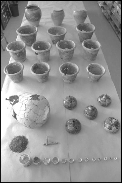 Figure 40. Some of the vessels found in the Page cellar.
By the 1720s a common way of storing wine was to place the bottles in brick or wooden bins. Typically straw or hay lined these bins with the bottles lying on top or upside down in order to keep the corks wet and sediments from settling. The drawback to this system, however, was that it required considerable space. The relatively small size of the cellar probably meant that the occupants had to find an alternative method for storing their bottles.
Instead of being binned, thirty-six wine bottles were placed upright on the floor against the foundation wall and twenty-four more were stacked, also upright, between the necks of the bottom ones (Fig. 42). Since some of these bottles still contained their corks and the wires used to hold them in place, they must have been full when the house burned
90
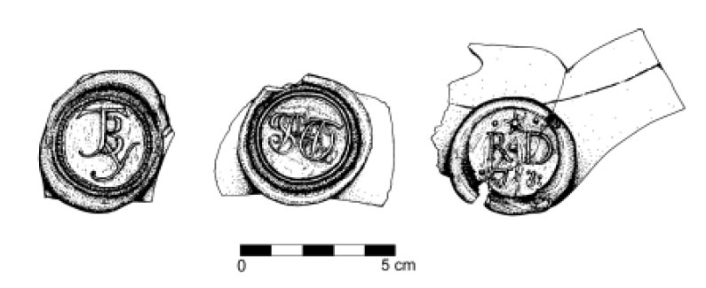 Figure 41. Bottle seals found in the Page cellar.
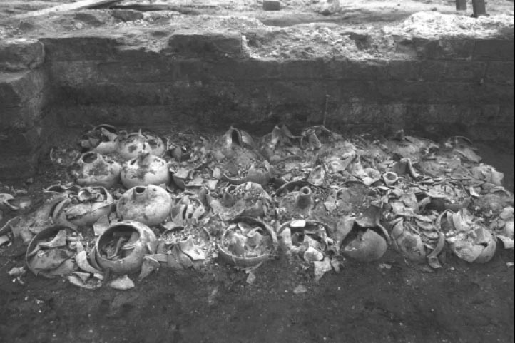 Figure 42. Stacked wine bottles.
down. This cache of sixty bottles was enclosed by the foundation wall to the south and a 4' 1¼ " long, 1' high wooden board to the north. That they sat upright suggests a variety of liquids could have been stored in the bottles. Beer, ale, cider, and certain kinds of wine, do not need to be aged for a long time and could have been stored in bottles that sat upright (Pittman 1995, personal communication). Nails in the foundation wall just to the west of the wine bottle cache suggest the presence of a 1'8" wide wooden rack. Artifacts recovered from this area indicate that case bottles, pharmaceutical bottles, and a box of unused English pipes were stored on the shelves of this rack. Nails in the wall to the east indicate that wooden shelves were attached to that portion of the wall as well. Given the heavy weight of full bottles, these shelves appear to have contained more bottles that were probably empty.
Figure 42. Stacked wine bottles.
down. This cache of sixty bottles was enclosed by the foundation wall to the south and a 4' 1¼ " long, 1' high wooden board to the north. That they sat upright suggests a variety of liquids could have been stored in the bottles. Beer, ale, cider, and certain kinds of wine, do not need to be aged for a long time and could have been stored in bottles that sat upright (Pittman 1995, personal communication). Nails in the foundation wall just to the west of the wine bottle cache suggest the presence of a 1'8" wide wooden rack. Artifacts recovered from this area indicate that case bottles, pharmaceutical bottles, and a box of unused English pipes were stored on the shelves of this rack. Nails in the wall to the east indicate that wooden shelves were attached to that portion of the wall as well. Given the heavy weight of full bottles, these shelves appear to have contained more bottles that were probably empty.
Along with a multitude of wine bottles, an unusual artifact called a scourer was recovered from the south room. This small metal tool was used to remove powder residue from the inside of musket barrels. It would have been threaded onto the end of a ramrod, and when not in use, it would have been stored in the musketeer's bullet bag. To date, only a few others have been found in Virginia including one at Wolstenholme Town which dates to the 1620s (Noìl Hume 1982; William Pittman, personal communication, 1995).
The room underneath the porch tower contained thirty-five wine bottles and one large stoneware storage jar that sat on the tile floor. This area also contained the largest number of ceramics found in the cellar. Since no nails were present in the walls for shelving, the placement of a small cache of wine bottles on the floor, 10 inches from the wall, suggests they abutted a raised storage area. Therefore, the ceramics and some wine bottles were probably stored on a low shelf that lined the periphery of the room. Three large and two small stoneware jars and seventeen earthenware flowerpots of various sizes were stored in this room.
The Renaissance not only influenced seventeenth-century architecture in England but gardens as well. Gardens were seen as extensions of the house, and they reshaped the landscape around the home into long paths, square planting beds, and in some cases, terraces. For a gentleman it was considered fashionable to be as knowledgeable about gardens as about architecture. Gardens were not only an extension of the house, but of the parlor, where people could walk and converse among the plantings (Bushman 1992). In Virginia some owners of Renaissance-influenced houses also emulated that kind of landscape. Arthur Allen's son, Major Allen, constructed an extensive garden at Bacon's Castle in the 1680s. The presence of twenty-one flowerpots (eighteen from the cellar) suggests an interest in gardening on the part of Page and subsequent residents of the Page house. Plowing of this area throughout the nineteenth century and construction activities in the twentieth century, however, have destroyed any garden remnants.
Household Artifacts
During the course of excavations only a small number of household-related artifacts were discovered (Fig. 43). Since large amounts of plaster and fireplace bricks fell down into the cellar from the first floor, other items located on that floor should also be present. Vessels found in the cellar are shown in Table 3.
One hundred and fifty-three wine bottles,3 seventeen half bottles, ten carboys, seventeen flowerpots, six ceramic storage jars, and over sixty salve pots were in the cellar at the time of the fire. The lack of domestic artifacts such as Chinese porcelain, a popular ware among elites, and the shortage of sets of wares, needed to entertain, conflicts with the abundance of other artifacts found in the cellar.
Although some items appear to have been removed, the presence of some tea wares indicates the resident was part of the late seventeenth century trend of tea drinking that was becoming fashionable among the gentry in England. The use of specialized and expensive serving equipment was one of the ways individuals communicated their position in society and reinforced social bonds. It was not until the late eighteenth century that tea drinking became accessible to almost everyone (Emerson 1992).
During the first half of the eighteenth century, people in Virginia were only starting to
92
 Figure 43. Assorted artifacts found in the Page cellar (top, left to right: stoneware mug and teapot; middle, left to
right: tobacco pipes, white salt glazed cappuchine, wine glass; bottom, left to right: tobacco pipes, fork, spoon,
escutcheon).
Figure 43. Assorted artifacts found in the Page cellar (top, left to right: stoneware mug and teapot; middle, left to
right: tobacco pipes, white salt glazed cappuchine, wine glass; bottom, left to right: tobacco pipes, fork, spoon,
escutcheon).
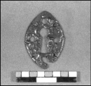 Figure 44. Escutcheon.
 Figure 45. Page cellar table glass.
acquire expensive tea wares. A study of sixty-one probate inventories from York County dating between 1732 and 1736 revealed that only eleven listed tea-related items. Of those eleven inventories, seven contained full sets, while four had only partial sets. The inventories of wealthier individuals typically recorded full sets while those of slightly lesser means listed only select pieces. The resident of the Page house had at least one teapot, bowl, and cappuchine. Whether or not he had a full set will probably never be known, but regardless, he was one of the few that
had such equipment.
Figure 45. Page cellar table glass.
acquire expensive tea wares. A study of sixty-one probate inventories from York County dating between 1732 and 1736 revealed that only eleven listed tea-related items. Of those eleven inventories, seven contained full sets, while four had only partial sets. The inventories of wealthier individuals typically recorded full sets while those of slightly lesser means listed only select pieces. The resident of the Page house had at least one teapot, bowl, and cappuchine. Whether or not he had a full set will probably never be known, but regardless, he was one of the few that
had such equipment.
While the Page house was quite fashionable when it was built in 1662, by the 1720s it was looked increasingly old fashioned as new Georgian style buildings were 93 constructed in nearby Williamsburg, such as the Governor's Palace. The appearance of such architecture in a planned town was in stark contrast to the Page house, with its outdated cross plan and casement windows. The Page family seat had moved to Gloucester County by the eighteenth century, where their continuing interest in elegant and expensive architecture could be seen in the construction of Rosewell, one of the most elaborate houses of the colonial period. Over twenty years had passed since the property was the Page family seat. By the time the house burned, a number of its outbuildings had been demolished and much of the land holdings were incorporated into the town of Williamsburg. Another sign of the property's decline was the condition of the cartouche. The reddish brown paint on the raised characters had faded and was sloppily covered over with white paint (Howlett and Swan 1996).
The archaeological evidence indicates that someone of the lower elite or upper middling sort was occupying the house. John Page III fits this profile. At his death he possessed 17,000 acres " of land Scituate lying and being upon the Freshes of James River in Virginia " along with" other lands Plantations Messuages Tenements and Hereditaments "(YCR, DOW 1728:523-24) . His land holdings and family pedigree indicates he was well off, but his death at twenty-seven and his prolonged sojourn in England meant he had little time to establish himself as part of the Williamsburg elite.
Table 3.
Vessels Found in Cellar
| 1 dipped white salt-glazed stoneware teapot | 1 smoky gray glass decanter |
| 1 white salt-glazed stoneware cappuchine | 1 clear glass bottle or decanter |
| 1 white salt-glazed stoneware tankard or can | 1 clear glass sweetmeat dish |
| 1 delftware teabowl | 1 stemmed wine glass |
| 1 Westerwald stoneware tankard stamped with the initials "A R" referring to Queen Anne who reigned from 1702 to 1714 | 1 iron knife blade |
| 3 fragments of a North Midlands slipware plate | 1 copper alloy spoon handle |
| 1 fragment of a North Midlands slipware platter | 1 iron two-tined fork |
| 2 fragments of a delftware plate | 1 mirror |
| 2 fragments of Chinese porcelain | 2 escutcheons, 1 with keyhole |
| 3 upholstery tacks | |
| 5 bed bolts | |
| 4 curtain rings | |
| 2 buttons, 1 shell and 1 lead alloy | |
| 1 caster | |
| 7 straight pins |
Cross-Mending Results
The scarcity of domestic finds implies the assemblage is incomplete. Although unmarried men, like John Page III, typically had fewer items than married couples, he would have had more possessions than were recovered. The lack of higher-quality table and tea wares may have resulted from relatives or friends claiming his possessions after his death or, alternatively, from people sifting through the ashes after the fire. Evidence of the latter comes from preliminary results of cross-mending.
96Crossmending is the process of reconstructing vessels by using the ceramic fragments found on the site to reveal relationships between different features or activity areas. When the ceramic sherds from this site were crossmended, fragments of flowerpots and stoneware storage jars stored under the porch tower mended with sherds from the stair tower and both rooms in the main section (Fig. 49). Pieces of an Iberian storage jar stored in the stair tower mended to fragments found in the large northern room and in the porch tower. Portions of a stoneware teapot were found in all four rooms. All of these fragments appear to have been scattered around by someone rummaging through the ash looking for salvageable items. Other evidence of scavenging comes from the robbed out north wall. A 14" wide trench was dug along the entire length of this wall in order to recycle the bricks.
Flowerpots in the Cellar
The eighteen flowerpots found in the cellar of the Page house suggest that the residents were actively involved in the creation and maintenance of gardens. Gardens in early Virginia have been interpreted as "metaphors for improvement, progress, and culture in the minds of many Virginian"(Martin 1991:xix) . The planting of gardens relied heavily on British tradition and the exchange and sale of plants between England and Virginia (Martin 1991; Sarudy 1989; Leighton 1976; Swem 1957).
The cultivation of more formal gardens required the use of ornamental plants, often outside the range of endemic and indigenous species available to colonial gardeners. A well documented import/export of plants between England and Virginia developed in the seventeenth century. English naturalists and botanists collected plants in the colonies for the gardens of England and Europe, and colonial gardeners included imported plants in their gardens. The transportation of plants was often risky; plants did not always reach their intended destination intact. Special boxes were designed to transport botanical specimens across the ocean, and trees and shrubs were transported in pots from England and throughout Virginia (Martin 1991, Leighton 1976, Stephenson 1959, Swem 1957).
Ensuring the delivery of live plants to gardeners required the protection of root systems during transportation. Long carriage rides and shipping damaged plants and colonial gardeners were specific in their instructions to English merchants (Fig. 46). A 1717 letter to the company of Perry, Lane and Perry in London from John Custis attests to this concern. Ordering striped holly trees and yew trees for his new garden he cautioned the merchants to "buy them as near the Water side as you Can, land Carriage will bee apt to shake and loosen them to much; let them bee Carefully put up in pots…"(Stephenson 1959:5) .
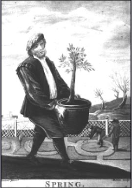 Figure 46. "Spring," by David Teniers.
Earthenware pots such as those found in the Page cellar would have provided the necessary protection for shipping plants as they were capable of supporting the root system and maintaining moisture for long periods of time. The pots were recyclable in a sense, after shipping the pots could be re-used in the garden as containers for small trees and flowers, generally foregrounding specimen plants within a larger garden arrangement. They were necessary items in the creation and maintenance of gardens, and their use has varied little over time.
Coarse earthenware flowerpots are the backbone of gardens today as they were in antiquity. They maintain their form and function into the twentieth century with little stylistic variation. Their composition and undecorated body implies a general function, unlike ornate pots used specifically indoors or as accents in a formal garden at the borders of parterres in strict geometric positioning (Fig. 47). It would appear that smaller pots with one central basal hole and one or more holes for drainage near the bottom were used for potting, displaying and transplanting herbs and flowers. Larger pots with a central basal drainage hole, and one or more holes located near the base on the side of the pot, were used for transporting, planting and nurturing young trees. This function can be documented through time consistently, beginning as early as 50 A.D., until the advent of plastic pots for shipping and transplanting in the twentieth century (Jashemski 1990; Huxley 1978; Hill 1577).
The flowerpots found at the Page house share similar characteristics (Fig. 48). All pots have flat bottoms, drainage holes pierced from the outside, and a simple raised cordon below the rim. They are red, unglazed, and the larger pots contain two or more side drainage holes. Their strong resemblance suggest the work of one potter (William Pittman, personal communication, 1997). Crossmended, the pots range in height from 7 to 10 inches, with base diameters ranging between 5 to 9 inches, and rim diameters between 8 and 12 inches. The earthenware pots are sensitive to climatic change, and early English garden books suggest indoor storage in the winter months to prevent freezing (Hill 1577). The pots at the Page house show no signs of exposure to the weather, which suggests that they were taken into the cellar for storage and remained there.
The remains of coarse earthenware pots similar to those found at the Page site have been found elsewhere in Williamsburg. Flowerpot fragments of have been found in the Thomas Jones house cellar, Francis Nicholson house cellar, and also at the Custis site, the three sites are somewhat contemporaneous with the Page house. Jones was a merchant in Williamsburg and the neighbor of John Custis. He was married to the niece of Mark Catesby, and a gardener of some note (Stephenson 1959). Governor Francis Nicholson lived for a short time in the vicinity of Custis and Jones. Nicholson was responsible for the layout of the town of Williamsburg and is described by Martin as "an urban planner with more than a passing interest in gardening and the role gardens could play in the disposition of a town,"(Martin 1991:30) . The gardens of John Custis are perhaps best known through his correspondence with Quaker botanist Peter Collinson and are well documented in Swem's Brothers of the Spade.
Gardens in early Virginia have been interpreted as indices of intent, status, and knowledge (Yentsch 1995; Kryder-Reid 1995; Leone 1990, 1989, 1984). They evoke a sense of permanence, and are often associated with brick architecture, the creation of towns, and self-sustaining plantations. The planting and seasonal maintenance of ornamental gardens reflect a long-term intellectual investment in the transformation of nature that was culturally held as a marker of stability and success in the wilderness. The flowerpots in the Page cellar are material evidence of an increasing colonial interest in horticulture that remained reliant on English tradition and trade until the late eighteenth century.
Figure 47. Anonymous, from Manual of Elementary Education.
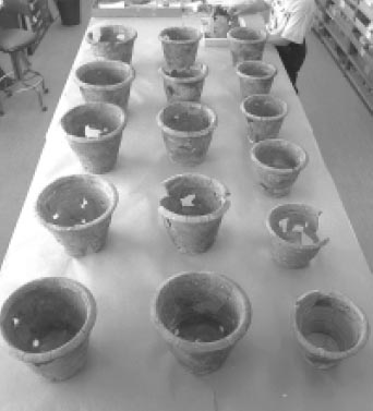 Figure 48. Flowerpots from Page cellar.
At this juncture it is impossible to know exactly what sort of garden was adjacent to the Page house. The similar characteristics of flowerpot fragments found on other sites imply that gardening was a shared endeavor and one that depended on interaction with others both economically and socially. It appears certain that the residents of the Page house belonged to a group of colonists intent on defining themselves within the larger realm of colonial society through the modification of the natural landscape.
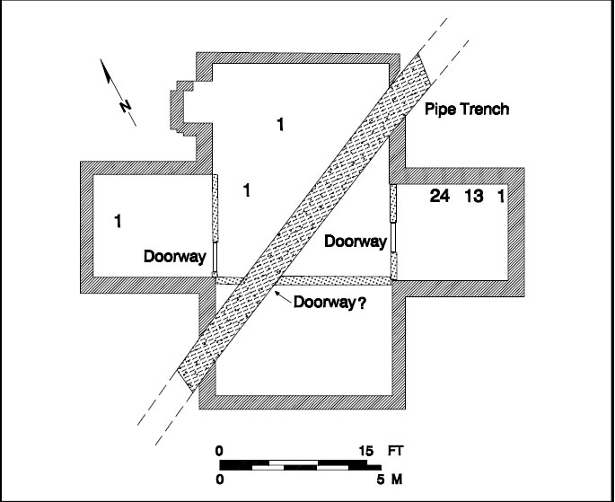 Figure 49. Spatial distribution of a single flowerpot.
The End of the Page Years
After John Page III died, the Bruton Heights estate passed to his sister Elizabeth, now married to David Bray. Upon the death of Elizabeth Page Bray the land descended to the heirs of Matproperty near Williamsburg (Virginia Magazine of History and Biography, 32:39-43; Hening 1969, 5:277-284).
When Mann (I) died, the construction of Rosewell was not yet complete, and Mann (II) inherited both the task of completing it, and paying his father's debts which exceeded the value of his slaves and personal property. Mann (II) attempted to pay his father's debts, and to cover the costs of educating and maintaining his younger brothers and sisters from the yearly profits of his father's estate. The magnitude of Mann (I) Page's debts made this impossible and the substantial legacies that Mann (I) Page had left to 97 his younger children remained mostly unpaid. In order to prevent creditors from bringing suits that probably would have resulted in the seizure and sale of the personal property and slaves, Mann (II) Page used his own money to cover expenses. Finally, Mann (II) Page sought an Act of Assembly that would enable him to sell various parcels of entailed land in order to pay off his father's debts, pay the younger children's portions, and repay himself (The Virginia Magazine of History and Biography, 36:39-43; Leviner 1987:13-16; Hening 5: 277-284).
Included in this act were "seven hundred acres of land, or thereabouts, adjoining the city of Williamsburg, in the county of York." The act received the governor's assent on 25 October 1744, and was sent off to England for which had already occurred, and one- half to be paid when Page had obtained the King's assent to an act of Assembly from the following session. Waller, in turn, could not sell any wood from the property or commit any willful waste on the premises until the assent of the King had been obtained. Waller later testified that this agreement had been first made verbally sometime during the October general court preceding the date of the written articles (York County Records, Land Causes (1746-1769):35-36). With the King's approval Mann Page completed the sale of his property in 1744.
98CHAPTER 7.
The Moody Subdivision
The social, political, and economic climate of Virginia had changed dramatically by the time Mann (II) Page sold the land that had originally been purchased by John Page (I). Those who had worked so hard to attract the colonial capital to Middle Plantation had succeeded. The changes in Williamsburg as it developed from a scattered community into an urban center brought about a conceptual shift in the way people viewed their landscape.
By the time Matthew Moody acquired the property in 1747, he was in a position to recognize the overcrowded conditions in the city of Williamsburg and take steps to capitalize on the acute need for property. He in effect created a subdivision when he began to divide the property and sell the plots in 1750. His efforts helped to relieve overcrowding within the city of Williamsburg by allowing artisans and others of modest means to escape tenancy and yet purchase land close to town. The neighborhood developed over a period of almost twenty years.
The Historical Background4
Although the Bruton Heights property had remained in the Page family for nearly one hundred years, it quickly passed through a succession of owners after Mann Page sold it in 1744. Benjamin Waller, being "wearied out with the frequent importunities of William Keith," consented on or about November 21, 1743 to sell him "as much of the sd land lying between the road to the Capitol Landing[,] the lands of John Coke, Thomas Cobbs & John Custis Esqr.[,] & the northern bounds of the city" as one hundred ninety pounds would purchase at the rate of twenty-eight shillings current money per acre. If the conveyance to Waller from Page were not upheld by the King's assent to the act of Assembly, Waller agreed to return Keith's money.
Before the King's assent was obtained, William Keith died heavily in debt. By his will dated March 27, 1743/4 and probated May 21, 1744, he bequeathed Waller's land to his son James Keith. A chancery suit brought by several creditors resulted in the division of this land and the sale of part of it to satisfy the testator's debts. It does not appear that Keith lived on this rural land before his death. He identified himself as a resident of Williamsburg in his will and his estate paid Philip Ludwell for a year's rent (YCR, DOW 19:282; YCR, Land Causes 1746-1769:42).
The portion of the land upon which Bruton Heights School now stands was sold to Thomas Penman sometime between March 16, 1746/7, when the York County court ordered it sold, and June 15, 1747, when the sheriff reported to the court that he had sold the tract to Penman for eighty- nine pounds, ten shillings and four pence half-penny. The deed, however, was not drawn up until August 13, 1747, probably because the land had not yet been surveyed. James Shields, Surveyor of York County, performed the survey on June 20, 1747; the survey was recorded with the deed.
The day following the execution of Penman's deed of purchase for the property, he in turn sold it to Matthew Moody, ordinary keeper of Williamsburg. Moody came 100 from a tavern-keeping family of long standing in York County, the two branches of which had taverns in Yorktown and Williamsburg. Matthew Moody obtained his first ordinary license May 20, 1734 and was appointed ferry keeper at the Capitol Landing the same day. He operated a tavern at the Landing until at least 1768 and he continued to live there until his death in June 1775. At his death he owned thirty mortgaged acres that adjoined his lots at the Landing (YCR,DOW 14:400).
When Moody purchased the acreage immediately north of the city from Thomas Penman, the deed conveying the land suggested that some improvement probably had been made to the property, but does not say exactly what, let alone where, these improvements were.
Moody began to subdivide this tract April 24, 1750, when he sold an acre bounding on John Coke's city lots and the main road to the Capitol Landing to Thomas Cobbs of York County. Moody continued to sell lots, in a northward sequence along Capitol Landing Road, until July 20, 1761, when he sold the last of the lots along the road. An act of Assembly providing that Moody's lots along the road leading to the Capitol Landing would be made a part of the city itself "so soon as the same shall be built upon" received the Governor's approval on April 14, 1759 (YCR, DB 5:370-71, 606).
Moody began after July 1761 to sell off portions of his land to the west of these lots. The first westerly tract sold shared its southern boundary with the city. On March 15, 1762, Moody agreed with John Greenhow for the sale of approximately six and one-third acres for sixty-three pounds, six shillings and eight pence current money. Moody and Greenhow further agreed that two streets four poles wide would be reserved in this tract and that Greenhow would connect the north-south street to Nicholson Street by extending it through a lot he had recently purchased there.
Moody himself created two streets within his subdivision north of Greenhow (now First) Street (Fig. 50). Moody Street extended northward perpendicular from Greenhow Street to Moody's property, although the Bucktrout Map shows it stopping somewhat short of that. The second street was called Bell Craig Street in Moody's deeds of sale for the neighboring lots, although the Bucktrout Map indicates that it was called Moody Street as well. Bell Craig Street extended perpendicularly from Moody Street, parallel to Greenhow Street, and emptied onto Capitol Landing Road. Greenhow Street, Moody Street, Bell Craig Street, and the lots along the main road, therefore, enclosed a block of lots that lie within the present Bruton Heights property. The remains of Moody Street and Bell Craig Street can be seen on aerial photographs taken prior to the construction of the school (Colonial Williamsburg negatives 53-W-777, 891455 CN, and 90-1649 CN). Moody then sold a few lots located on the eastern end of First Street. These lots changed hands at a furious pace.
The Archaeology of the Moody Subdivision
Archaeological evidence for the development of the Moody subdivision was found throughout the Bruton Heights parcel (Fig. 51). This evidence was gathered from several phases of archaeological testing in the 1980s and early 1990s that determined that development was confined, in large part, to those lots along Capitol Landing Road and the series of lots immediately behind. The presence of coal and
slag in these areas indicates that the occupants of these sites probably engaged in craft-related trades on these properties. John Shephard, for example, ran his harness-making business from his property.
101
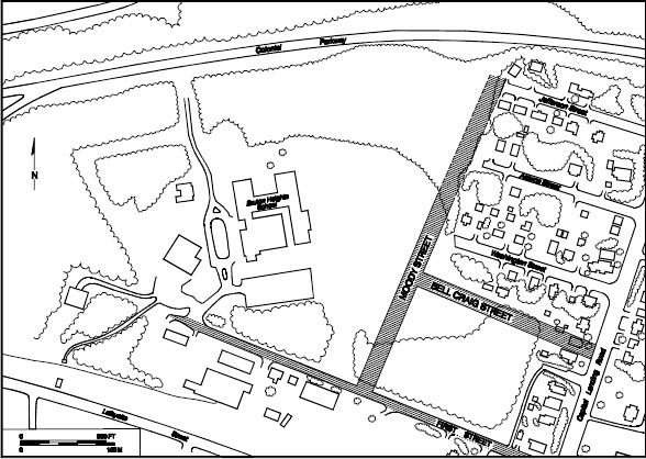 Figure 50. Eighteenth-century roads associated with the Moody subdivision.
 Figure 51. Overview of eighteenth-century landscape.
Eventually, he owned most lots between Capitol Landing Road and Moody Street to the west.
Figure 51. Overview of eighteenth-century landscape.
Eventually, he owned most lots between Capitol Landing Road and Moody Street to the west.
On September 7, 1779, John Shepard sold three quarters of an acre to Bruton Swillivan of Bruton Parish, York County, for two thousand pounds current money. Swillivan paid one thousand two hundred fifty pounds of the purchase money and mortgaged the lot to Shepard on September 27, 1779 to secure payment for an additional thousand pounds within a year. The lot is described in the deed of sale as follows:
… all that Piece or Parcel of Land containing three fourths of an Acre or Lot and half lying and being in the Parish of Bruton and County of York aforesaid in and near the City of Williamsburgh and bounded as 102 followeth on the East by the said John Shiphard on the South by John Greenhow on the West by Moody Street and on the North by Joseph Prentis And all Houses Buildings Yards Fences Waters Water courses Gardens Orchards Ways Profits commodities Hereditaments And Appurtenances… (York County Records, Deeds and Bonds 1777-1791:85-86,116).
A portion of Shepard's land was tested archaeologically in 1983, as part of a proposed road improvement project. This site (44WB28), located at 400 Capitol Landing Road, contained intact archaeological deposits dating to the late eighteenth/early nineteenth century (Hunter, Samford, and Brown 1983:vi). The lot was probably unimproved at the time it was purchased given the low sale price of ten pounds. By 1782, however, the Frenchman's Map shows that several structures had been constructed along Capitol Landing Road near this site, which extends onto the southeastern corner of the Bruton Heights parcel. Testing on the property in 1983 exposed brick foundations, the remains of a possible cellar, postholes, a boundary ditch, and "a high density of important eighteenth-century and nineteenth-century artifacts"(Hunter et al. 1983:54). Furthermore, the presence of coal and slag suggests craft-related activities (Muraca and Hellier 1992:31).
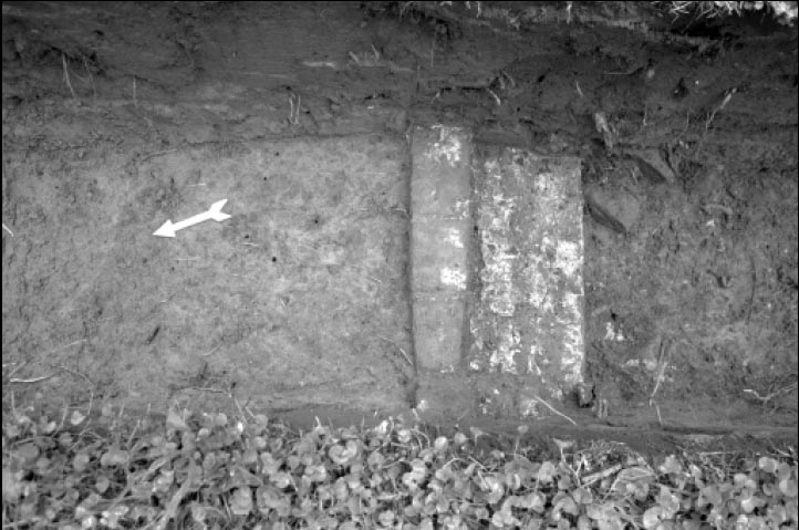 Figure 52. Moody subdivision period foundation adjacent to Capitol Landing Road.
Artifacts recovered during the construction of an addition to the home at 400 Capitol Landing Road in 1995 confirm the late eighteenth/ early nineteenth-century attribution for the site. Brick foundations were exposed once again when the footings for the addition were excavated (Fig. 52). The foundations appear to relate to the same structure identified during the 1983 excavation. Judging from the orientation of these remains, the majority of the structure now lies concealed beneath the addition to the house.
The rear extent of the property was defined during archaeological testing conducted on the Bruton Heights property in 1990. This area of the site extends seventy feet into the property and consists of a light scatter of mid-to late eighteenth-century artifacts. Spatial analysis of this material 103 indicates that the focus of activity on the site was farther to the east, closer to Capitol Landing Road.
A site associated with the back of the contiguous lot to the north was also identified during the 1990 testing. Mathew Moody sold this half-acre lot fronting Capitol Landing Road to James Atherton in 1762. This site (44WB67) extends almost twenty feet into the school property and contains domestic artifacts dating to the eighteenth and nineteenth centuries. While this scatter extends to the north and east beyond the boundaries of the school parcel, the major concentration appears to be located to the east (Muraca and Hellier 1992:31). The "Frenchman's Map" (1782) and Desandrouins Map (1781) show structures along Capitol Landing Road within the vicinity of this site. Discrete concentrations of artifacts identified within this site suggest the possibility of activity areas or structural remains (Muraca and Hellier 1992:31). No features were located during this phase of testing.
 Figure 53. Remains of brick structure dating to Moody subdivision period.
Another concentration of artifacts was discovered along First Street approximately three hundred thirty feet west of the southeastern corner of the parcel. William Rose purchased this lot in 1762 and eventually sold it to John Shephard in 1774. Testing revealed a moderate to heavy scatter of mid-eighteenth-century artifacts and three concentrations of brick rubble, which suggested the presence of a several structures (Fig. 53). A trashpit was also located. The assemblage recovered from the site includes both domestic and craft-related items (Muraca and Hellier 1992:33). The Desandrouins Map 104 (1781) shows a structure in this area. Historical research indicates that this was a lot bordering Greenhow Street.
Alexander Craig's Lot
A seemingly isolated fenceline, possibly marking the boundary between the Raleigh Tavern pasture to the west and the land that Alexander Craig bought from Moody in 1763, was discovered at the western end of the school property in the vicinity of Craig's 1768 purchase north of Greenhow Street. Craig, a printer, probably did not improve this acreage since he continued to live in Williamsburg where he owned lots on Duke of Gloucester Street, the Waller Subdivision, and the Johnson Subdivision. The following advertisement of the sale of his property after his death indicates that the property that he had purchased from Moody was used as pasture:
TO be SOLD, on Tuesday the 4th of March, at 4 o'Clock in the Afternoon, to the highest Bidders, the Lot and Houses on the main Street in Williamsburg, adjoining the Raleigh Tavern, where Mr. Alexander Craig formerly lived. A House and Part of a Lot in Waller Street, with a Lot and Stable some little Distance therefrom. A pasture of six or seven Acres, enclosed, adjoining Mr. Southall's Pasture …(YCR,DOW 22:322-23; Virginia Gazette, 7 February 1777).
Three rectangular postholes marked the location of the earliest fenceline on this lot. Each of the posts measured approximately 2 feet by 10 inches. Once the olive brown sandy loam was removed the depth of the original holes in this series was determined to be between 2 and 7 inches below existing grade. Evidence of second, smaller holes were found in the southern half of each of these holes. Given the fact that none of the interior holes was discovered until the fill from the larger holes was removed, it seems that the larger, shallow holes were dug to remove posts from the deeper holes. It is difficult to date, however, this fenceline since none of the features contained artifacts. It appears that once the posts to the original fence were removed, the posts for the second were put in between the holes of the first line. The posts in the second line also showed signs of replacement and lay on 8 to 10' centers. The remains of a wooden post were removed from one hole. This post was identified as pine, and although pine was not typically used for fencing, it would have been readily available. A fragment of delftware and a piece of American stoneware were found another hole, with the American stoneware dating the filling of the hole, thus the installation of the second fence, to sometime after 1730.
A ditch associated with this boundary line lay two feet east of the postholes and extended 21 feet to the southeast before tapering off in the ravine. The ditch averaged 1 foot in width and 6 inches in depth and was filled with an olive-brown silty loam. The profile of this layer contained dozens of tiny horizontal striations, indicating that the trench silted in over time. This was a common problem for farmers who had to "scour" or clean trenches every year.
Not much activity occurred in this part of the property judging from the paucity of artifacts. Artifacts from the trench did include several brick fragments, a shell, a nail, and a piece of wine bottle glass. A sherd of white salt-glazed stoneware and a piece of creamware were also recovered. The presence of creamware suggests that the ditch was not completely silted in before the mid-1760s, since creamware was not produced until 1762. Seeds from sedge grasses associated with meadows and farmland were discovered in soil samples taken from ditch. Seeds of wild raspberry were also found.
Craig's pasture was sold in the late 1770s. The purchaser of the pasture was 105 James Nichols of Williamsburg. The executors deeded him the 4 5/8 acres on April 29, 1779. The deed states that Nichols had purchased the property at public auction, presumably the one advertised in February 1777, so that the deed appears to have been executed some time after the actual purchase. Nichols was a barber and perukemaker who had moved from London to Petersburg; and then to Williamsburg by February 1775 when he advertised for a horse that had been stolen from his Williamsburg lot. He advertised his house for rent in December 1779 as well as his intention to leave town to keep the Swan's Point ferry. He was taxed for one lot in Williamsburg from 1782 through 1787. In 1788 his estate was taxed for only one lot. That he was not taxed for his pasture in the Moody Subdivision indicates that he had sold the pasture prior to his leaving. Another possibility is that the property never appeared on the tax list because it was never approved and thus never officially annexed to the city (YCR, DB 6:1777-1791, 57-58).
James Barrett Southall's Lot
Further evidence of the landscape dynamics that occurred during the Moody period was discovered two hundred fifty feet northeast of the long-standing boundary line (44WB70). How this area was used during the eighteenth century is uncertain for Moody clearly did not live there, but he might have rented out some part of it. He was later using at least part of it for agricultural purposes as a deed dated May 29, 1760 indicates. The deed details the sale of thirty-five acres of this tract, the northwest portion, to Lt. Gov. Francis Fauquier. The bounds of the acreage sold by Moody include the corner of a ditch that enclosed Moody's cornfield. The complete boundaries are as follows:
Beginning at the Corner of the Land of the said Francis Fauquier on the Capitol Spring branch Thence up the said Branch to the said Land formerly Andrew Andersons now belonging to the Raleigh Tavern Thence along a Line of that Land North Sixty Degrees East four Chains to the Corner of a Ditch lately inclosing the said Moody's Cornfield Thence along that Ditch as it Meanders to a Stone marked JP in John Cokes Line Thence along his Line North Forty nine degrees West Eleven Chains to the Land of the said Francis Fauquier and thence along his Line South forty one Degrees West twenty one Chains to the Beginning(YCR, Deeds and Bonds 5:224-27; DB 6:(1755-1763):249-51).
A later deed, dated June 21, 1762, refers to the same general area as Moody's pasture (YCR, DB 6(1755-1763):455-56).
Later deeds suggest that this area is in the vicinity of the boundary between Alexander Craig's 1768 purchase and the twenty-acre parcel that Moody sold to James Barrett Southall a few months later. When Craig sold this property in 1779, his land is described as a "pasture" adjoining a pasture owned by James Southall (YCR, Wills and Inventories, 22:322-23). In the advertisement of the sale of Craig's property the reference to "Mr. Southall's pasture" could have been either to the "Raleigh Tavern pasture" that Southall had purchased in 1771, or to the tract that Southall had purchased from Moody. It does not seem likely that he lived on the acreage he bought from Moody.
The post and rail fence and ditch associated with the Southall lot were oriented due north (Fig. 54). Eleven postholes set at an 8 foot intervals define the fenceline. All of the holes were very regular, averaging 1 foot by 9 inches in size. The depth of these holes ranged between 6 and 8 inches below grade. The posts for this fenceline appear to have been put in place before much activity occurred
in the area because none of the holes contained artifacts. There was no evidence of postmolds in any of the postholes and all of the excavated features had very irregular
106
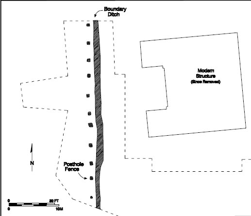 Figure 54. Southall fence and ditch.
 Figure 55. Southall period ditch.
bottoms. It appears that the posts were removed before they could rot in place.
Figure 55. Southall period ditch.
bottoms. It appears that the posts were removed before they could rot in place.
The ditch associated with this fence runs the 103 feet length of the open excavation area (Fig. 55). It is 2' 2" wide and 4" deep and was filled with a brown silty loam sealing a 1 inch thick layer of silt. This trench remained open and filled slowly as eroding soil washed in and settled. Unlike the postholes, the trench produced a number of artifacts dating to the mid-eighteenth century. A total of one hundred twenty-nine artifacts were recovered from the ditch, consisting mainly of ceramics (22%), storage and table glassware (18%), and architectural debris (31%). The ceramics included a wide 107 range of types from delftware to a fragment of an Iberian storage jar. A mean date of 1750.3 was calculated from the ceramics in this ditch. A flat roofing tile and 6 fragments of window lead probably came from the seventeenth-century Page occupation and were redeposited when the area was reused several decades later. Unfortunately, the window lead fragments were too small and degraded to be compared to the marked examples found in the redeposited domestic assemblage and on the kiln site.
Later in the eighteenth century, another north-south fence was constructed sixty feet east of the fence and ditch. This post and rail fence consisted of ten posts at an interval of 8 feet over a distance of 73 feet. Posts in this line were 1'6" feet square and averaged 9 inches in depth. All of the postholes were filled with an olive brown sandy clay, while two included post molds averaging 5" on a side. Four of the postholes had been repaired or replaced. The intruding holes produced the only artifacts associated with this fenceline, suggesting that activity in this area increased between the time the fence was constructed and the time it was repaired. Over half of the artifacts recovered were architectural in nature. Unfortunately, none of the artifacts were dateable.
Other changes occurred after the second post-and-rail fence was constructed. The ditch that extends the length of the original north-south fence cuts across the top of the seventeenth-century industrial ditch, clearly demonstrating that it postdates this feature. Likewise, the fenceline and ditch cut the center berm of the suspected palisade.
The ditches associated with the palisade, however, appear to have been reused later. A fence was built along the top of the linear palisade mound, and the adjacent ditches were redug. This type of fencing had become common by the second half of the eighteenth century. The ditch and berm combination prevented livestock from escaping under the fence, drained water away from the fence posts, and saved valuable lumber. In a 1778 letter to George Washington, John Parke Custis commented on the importance of ditching:
… the expense of keeping this Plantation in culture, from the great Scarsity of Timber, the number of roads running through the Land, and the amazing Deal of Ditching necessary to inclose the Fields … (Harbin 1986:275).
Silt and other debris had to be removed from the ditches periodically to maintain the effectiveness of the fence. This scouring or ditching was a time-consuming activity on farms and plantations. In 1770, Landon Carter made an entry into his diary that expressed concern about rebuilding the fence around the meadow and scouring the ditches, "for really I have not time to new ditch it, a work that must be done this year, god willing" (Carter 1770: I:561).
Nearly two hundred artifacts were recovered from the north and south ditches of the suspected palisade. Page-period material and eighteenth-century artifacts were common, with architectural debris and material related to foodways accounting for seventy-three percent of the assemblage. The 86 pieces of architectural material includes brick, nails, window glass, and roofing tile that probably related to the Page period. While case bottle glass and some of the delftware might date to the seventeenth century, most of the 51 pieces of ceramics and glassware date to the mid-eighteenth century. The mean ceramic date for the artifacts in the palisade ditches was 1740.5. The mean ceramic date also suggests that both ditches were open at the same time. The mean date of 1739 computed for the northern ditch is so close to the 1742 date calculated for the southern ditch that it is reasonable to assume that they were contemporaneous.
108The remains of eight postholes exposed along the center of the berm tell a similar story. Four original posts believed to belong to the palisade of 1634 were identified along the berm. Three of these were discovered west of the brick cottage while the fourth was found in front of the structure. Originally, huge structural posts were erected using a 15 foot interval. The posts were connected by rails and pales were nailed or pegged to the rails. The posts averaged 2'6" by 2' and were approximately 1'6" deep. The original fill in the bottom of the holes was a yellowish orange clay, devoid of artifacts. This also matches the description of the fill of the posthole exposed in the trench excavated across the berm in the northeast corner of the property. The palisade appears to have fallen into disrepair within a decade of its construction. A new palisade was constructed elsewhere in 1646 and by 1683 the palisade of 1634 was described as "the old trench where the pales stood" (YCR,DOW 1:159-160).
The archaeological evidence suggests that a post and rail fence was constructed down the center of the berm sometime after 1740. The posts to this fence intruded on all but the easternmost palisade holes. A shorter interval of 7 feet was used for this line, and posts were also placed between the location of the original posts. The five eighteenth-century postholes measure 1'5" by 1'5" and averaged 8 inches in depth. The remains of postmolds averaging 7 inches in diameter were identified in three of the five holes. One of the holes showed signs of repair or replacement, while in another the post appears to have been removed.
The remains of five modern postholes were also discovered along the center of the berm. Although none of these features were excavated, the regular 8" diameters of the holes and the dark postmolds surrounded by coronas of bright orange clay are telltale signs of a modern post installed using an auger. This most modern series of posts probably marks the location of the barbed-wire fence shown in the aerial photograph taken in 1927.
It is difficult to determine how this land was used in the eighteenth century. Much of the area surrounding the school garage and home economics cottage had been heavily disturbed during the construction of the school and the associated buildings in 1940. As a result, seventeenth- and eighteenth-century layers were disturbed beyond recognition, if not wholly destroyed. Maps do not show any structures or improvements in this area. Land transactions, however, mention "the said Moody's cornfield" and later, "Mr. Southall's pasture"(YCR, Deeds and Bonds 5:224-27) .
Fortunately, the disturbance from construction was confined to the terrace where the school structures are situated. A light scatter of eighteenth-century artifacts was identified on the slope north of the cottage. The artifact scatter was heaviest near the edge of the terrace and extended down the slope nearly 50 feet before diminishing. This scatter of debris, known as sheet refuse, accumulates slowly as the result of continuous activity in the area. It can often indicate the location of activity areas as well as boundaries that have long since disappeared. The concentration of material at the top of the slope indicates that the focus of activity was on the terrace. Judging from the way the artifacts were concentrated near the terrace and tapered off down the slope, the ravine was probably peripheral to the activities taking place at Bruton Heights. Many of the artifacts on the slope were probably deposited there through erosion. A silty wash layer was found across the site.
The Trash Midden
A large, mid eighteenth-century trash midden was identified at the head of a silted-in ravine on the slope north of the brick cottage. The sheet refuse originated from the terrace to the south, tapered off and ended within twenty feet of the midden indicating the midden was deposited near a property boundary.
The midden at Bruton Heights was oriented on a southwest/northeast axis and measured approximately 12 feet long (northeast/southwest) by 2 feet wide (Figs. 56 and 57). The average depth of the midden was 8 inches. The artifact concentration was lower at the northeast end of the deposit and heaviest at the southwest end, suggesting that some of the material may have washed a
 Figure 56. Eighteenth-century midden.
110
Figure 56. Eighteenth-century midden.
110
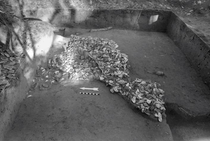 Figure 57. Eighteenth-century midden.
111
short distance from where it was originally deposited. The poor preservation of bone from the feature indicates that the deposits remained exposed
to the elements long after it had been dumped.
Figure 57. Eighteenth-century midden.
111
short distance from where it was originally deposited. The poor preservation of bone from the feature indicates that the deposits remained exposed
to the elements long after it had been dumped.
Mystery Feature
Four roughly square holes oriented along the same axis were discovered beneath the midden (Fig. 58). Each of the holes measured approximately 1'4" square and 1'6" deep. The holes appear to be set along a deliberate interval of 4 feet between the first two holes, 6 feet between the second and third hole, and 4 feet between the third and fourth holes. Removing the dark brown loamy fill from the holes revealed that material from the overlying midden had spilled into each.
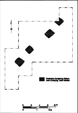 Figure 58. Mystery feature.
The midden produced a large assemblage of two thousand fifty-one artifacts including over one thousand one hundred pieces of oyster shell, bone, and brick. Some fifty-six pounds of brick and five bushels of oyster shell were also recovered from this feature. The presence of flat pegtiles dating to the Page period suggests that some of this material may have originated from the nearby Page complex.
Nearly 800 fragments of faunal bone survived. Many were severely degraded reflecting the effects of erosion and weathering. Water probably washed small bones down the slope, leaving the larger domestic livestock remains to weather in the sun.
The Depositional History
Crossmending indicates that the trash midden was probably deposited in a single episode. Over fifty mending relationships were identified within the midden. These include contiguous or abutting relationships where pieces fit back together, and non-contiguous mends where pieces are judged to belong to the same vessel on the basis of physical characteristics. The seventy-one 113 ceramic vessels were represented by one hundred fifty-eight artifacts exhibiting a mending ratio of 2.2:1. Thirty-three of these were contiguous mends. Of the fifty-eight glass vessels, forty-one were bottles and seventeen were table glass. There were no contiguous mends identified for the forty-one bottles. The bottles are represented by fifty artifacts with a mend ratio of 1.2:1.
Table glass shows the same ration of artifacts to vessels. Twenty-one artifacts account for the seventeen glass vessels. Two of the mends were contiguous. Mends located throughout different sections of the midden show contemporaneity. Likewise, crossmends between the artifacts in the midden and those contained in the postholes beneath it demonstrate the same pattern.
114The four postholes discovered beneath the midden remain a mystery. Trash recovered from the four holes demonstrates that the holes were clearly open when the midden was created. Two mending relationships identified between the two inner holes makes this apparent. It would not make sense to dig four small holes simultaneously for one deposit of trash. The deliberate intervals of 4', 6', and 4' between the posts and the similarity in the size of the holes suggests that they were intended to fulfill some other purpose than garbage disposal. They may mark the location of a fenceline that was removed when the trash was dumped in the ravine. The location of the holes at the head of a ravine on the side of a slope are problematic to this interpretation, however.
James Southall owned Wetherburn's Tavern when he bought twenty acres from Matthew Moody in 1768. His purchase of the Raleigh Tavern in 1771 included the Raleigh Tavern pasture that bordered Alexander Craig's land to the east. It is possible that Southall bought out Alexander Craig's portion of the Moody subdivision sometime after 1779 to link his own two pieces of land. The ceramic and pipestem dates correlate with the early part of Southall's ownership. While the pipestems indicate that the feature was deposited shortly after Southall purchased the site in 1768, the ceramics from the midden suggest otherwise. The peak range ends in 1770, closer to the time the Raleigh Tavern was purchased. Likewise, the artifact assemblage recovered from the feature appears to represent a tavern context instead of a domestic context. Therefore, the trash midden appears to be associated with Southall's purchase of the Raleigh Tavern in 1771. Trash deposits often date to turnovers in land ownership (Mrozowski 1984). Since, new owners would often throw out what previous occupants leave behind. The ravine behind Southall's pasture was an ideal spot to dump a large load of garbage from the Raleigh Tavern.
Artifacts from the Trash Midden
Ceramics and glassware account for nearly three-quarters of the artifacts found in the midden. Most of this material dates to the mid-eighteenth century. Using Stanley South's mean ceramic dating formula (South 1977), a mean date of 1746 was computed. The five hundred eighty-two glass and ceramic artifacts in the assemblage represent one hundred twenty-nine different vessels. The twenty-three different vessel forms reveal the ever-increasing elaboration of artifact types that occurred during the eighteenth century. This elaboration of artifact types correlates with the "Georgianization" of English and English colonial society. The international scope of the ceramics, including German stoneware, Chinese porcelain, and a Spanish coarseware vessel, illustrates the growth of a global community that was connected, and in many cases held together, by trade. The ware types included drinking vessels and tea wares, table ware, food preparation and storage vessels, and toiletry and pharmaceutical vessels. The contents of the assemblage reflect the variety and quantity of bottles, glassware, and ceramics typically associated with a tavern assemblage.
Drinking Vessels and Tea Wares
One-quarter of the vessels identified in the Bruton Heights midden were items associated with drinking. Many different types of drinking vessels were used by the mid-eighteenth century, reflecting the increasing specialization of functions and the proliferation of consumer goods. The vessel forms and material from which they were made provide a good indication of the functions they fulfilled. The drinking vessels found in the midden represent tea wares, mugs and tankards, and tumblers and wine glasses.
Eight tea ware vessels (11% of the total) were identified in the midden assemblage. The passion for tea drinking was supported by a burgeoning trade with China. The China trade greatly influenced the types of vessels used for tea consumption, which motivated many European pottery manufacturers to mimic Eastern styles. The five Chinese porcelain saucers are typical for the period; they display an underglaze blue decoration. A Chinese porcelain tea bowl was also found in the midden. The cup is a Batavian porcelain, decorated on the exterior with a clay slip that produces a lustrous brown color. A handleless bowl, it reflects the strong Chinese influence on tea wares. Handles on cups were a Western innovation that supplanted the bowl forms later in the eighteenth century.
Tea wares were often imitated in other ceramic types, as a single white salt-glazed stoneware saucer from the midden demonstrates. White salt-glazed stoneware was at the height of its popularity in 1746, and its white body was well suited for imitating porcelain. A fragment of a tortoiseshell tea pot shows that popular tea wares were subject to the latest fashion. This refined earthenware, named for its brown, clouded underglaze decoration, was popular between 1740 and 1775.
Mugs and tankards were common drinking vessels throughout the eighteenth century. Unlike tea wares, their role was much less prescribed by social customs. They were produced in pint and quart sizes and used primarily for the consumption of cold beverages such as beer and ale. Nine mugs and tankards were represented in the midden assemblage. All but one of these was stoneware. They included a Fulham stoneware mug and the remains of a Staffordshire tankard. English brown stoneware mugs and tankards enjoyed a long production period. The production of Fulham stoneware began sometime around 1690 and continued until 1775, while Staffordshire stoneware was made between 1700 and 1800 (Noël Hume 1969:114). The two Nottingham stoneware tankards identified from the assemblage were most popular between 1700 and 1750 although they continued to be produced until 1810. White salt-glazed stoneware accounted for one-third of the mugs and tankards, which reflects the fact that it was at the height of its production during the period represented by the assemblage. A single Westerwald mug/tankard found in the assemblage is also common for the period and demonstrates the continued popularity of German stoneware even as the British pottery industry took control of the market.
The predominance of refined glassware was perhaps the biggest surprise in the midden assemblage. Fifteen clear leaded glass tumblers and wine glasses represent sixty-three percent of the drinking vessels identified from the midden. They include nine tumblers and six pieces of stemmed ware. The tumblers all appeared to be of the same type. The typical straight sides and empontilled bases of the glasses indicate that they were freeblown. None of the examples was decorated. Tumblers would have been used for the more refined beverages such as punches and liquors.
There were three patterns in the six pieces of stemware. Three were undecorated wine glasses. The examples from Bruton Heights have the "thick, plain feet" common on the types of wine glasses found in taverns between 1740 and 1750 (Noìl Hume 1969:192). One glass had an air-twist stem, a type of decoration used between 1735 and 1760. Opaque-twist stems saw the height of their popularity between 1745 and 1775 (Noìl Hume 1969:190-191). Two opaque-twist stems were found in the midden. The thicker coils within these stems indicate that the wine glasses date between 1755 and 1775.
The drinking vessels and tea wares represented in the midden assemblage exhibit a pattern more typical of that exhibited by tavern assemblages. Tavern assemblages differ from their domestic counterparts in that they have a higher percentage of drinking vessels and more wine glasses and specialized forms (Bragdon 1981:35). Drinking vessels and tea ware account for a quarter of the vessels from the Bruton Heights midden. The ratio of drinking vessels to tea ware is 3:1, indicating that drinking alcoholic beverages was a more common activity than tea drinking. This is similar to the Shields Tavern assemblage, where the ratio of drinking vessels to tea ware is 4:1 for the early period (1708-1738) and 3:1 for the late period (1738-1751) (Brown et al. 1990:76, 114). The predominance of refined glassware over the stoneware mugs and tankards typically associated with taverns might reflect a difference in the type of fare available in taverns.
Table Wares
Kym Rice observes that "although the emphasis on cuisine was secondary, it was nevertheless an important part of the customer's tavern experience"(Rice 1983:86). Table ware represents a significant part of the midden assemblage where it accounted for a quarter of the identified vessels. By comparison, it made up twenty-four percent of the Late Tavern period vessels (1738-1751) at the Shields Tavern site. Table wares are divided into flat and hollow forms. Hollow ware is used describe forms such as bowls and tureens. That they were designed to hold "wet dishes" (Brown et al.1990:119). They ranged in size from individual bowls to large serving pieces for the table. Flat ware, on the other hand, was designed for meat and vegetables. Like hollow ware, flat ware forms include individual pieces such as saucers and plates and larger platters for serving an entire table. Flat ware accounts for sixty percent of the ceramic vessel types in the assemblage while hollow ware represents thirty percent. The table ware from the Bruton Heights midden shows the shift from a medieval pattern of communal dining and with its shared soups and stews to a more standardized cuisine characterized by individual places settings with specialized pieces.
Three hollow ware vessels of indeterminate form and function were included in the midden assemblage. An English delftware vessel and a piece of North Midland slipped hollow ware probably represent small pots, a form found on most colonial tables throughout the eighteenth century. They were often made of cheaper ceramics such as delft and slipware. The production of North Midland slipware, often called Staffordshire slipware, began during the second half of the seventeenth century and continued until 1795. An English soft-paste porcelain hollow ware vessel was also identified. English porcelain is often described as soft paste porcelain because the paste, or body, is softer than that of Chinese porcelain. Not enough of the blue underglaze decoration survived to identify the porcelain. True to form, however, the decoration is transfer-printed; the designs on Chinese porcelain is always hand applied (Noìl Hume 1969:137).
Each of the ten bowls identified in the midden assemblage appears to have been part of an individual place setting. Two of the bowls were made of Buckley ware. This low quality coarse earthenware was common throughout the eighteenth century. It has a black-glazed red clay body that is often heavily ribbed. The three English delftware bowls found in the midden are also common for the period, although their popularity was waning. In contrast, white salt-glazed stoneware, which was introduced in 1720, was at the height of popularity in 1750. Five plain white salt-glazed bowls were found at Bruton Heights. The remains of two Chinese porcelain bowls were also recovered. Porcelain was still an expensive item at mid-century although price and quality would fall during the second half of the eighteenth century (Noìl Hume 1969:256257).
Seventeen individual pieces of flat ware were found in the midden. Delftware vessels include three plates and one platter. An English stoneware plate was also identified. The presence of five Chinese porcelain plates is somewhat unusual. Porcelain was a luxury item and people tended to hold on to it even when it was damaged. White-salt glazed stoneware accounts for seven plates and one serving platter. Part of the appeal of white salt-glazed stoneware was due both to its greater similarity to porcelain than delft ware, and the molded designs that often appeared on the body of the vessels. The designs were immediately popular and survived in subsequent ceramic types. Two of the white salt-glazed plates had a bead-and-reel design while another was molded and embossed. The same dot-diaper-basketweave pattern embellished the rims of five plates and probably indicates the use of a matching set of dishes, a practice that became increasingly common over the course of the eighteenth century.
Food Storage and Preparation Containers
Containers associated with preparation and storage of food accounted for thirty-six percent of the vessels from the Bruton Heights midden and included pans, jugs, jars, and bottles. There were four vessels found in the midden that were used in food preparation. Three of these were North Devon Gravel-temper milk pans, a common item in colonial kitchens. Milk pans were originally associated with dairying but soon became used for a variety of purposes (Brown et al. 1990:121). The other food preparation coarseware found in the midden was a colonoware bowl, which has come to be recognized as an African-American pottery type (Ferguson 1992; Deetz 1993).
The vessel forms associated with storage included jars and jugs. Jars were used to store a wide variety of foodstuffs ranging from grains, herbs, and fruit to pudding and butter. All but one of the six storage jars identified in the assemblage were utilitarian. The utilitarian vessels were a Buckley ware jar, one Iberian jar, two of Fulham stoneware, and a Westerwald stoneware piece. Four Westerwald jugs were also identified. While jugs were used to hold various liquids, Chinese porcelain storage jar was an exception: this piece was almost certainly decorative.
The majority (30%) of the vessels identified in the midden, however, were bottles. The thirty-two wine bottles represented in the assemblage accounted for sixty-four percent of the bottle types. One of the bottle necks still had the wire enclosure still in place. The remains of three case bottles were also recovered. The straight sides and flat bottom of case bottles were formed by blowing glass into a four-sided mold (Noìl Hume 1969:62). Although globular wine bottles began to predominate in trade after 1650, case bottles continued to be used in large quantities through the nineteenth century. While the case bottle may have been easier to pack, ship, and store, the squatter wine bottle was much sturdier and broke less often than the case bottle (Noìl Hume 1969:60-71). A single colorless lead bottle was also identified in the assemblage. This was a probably a finer container or decanter intended for table use.
Toiletry and Pharmaceutical Vessels
The midden contained ten vessels that fulfilled pharmaceutical or toiletry functions. The pharmaceutical vessels included three delftware ointment/salve jars, which are commonly found on sites from the seventeenth and eighteenth centuries. While early delftware ointment and salve jars were decorated in a variety of color combinations, they had been reduced to crude, white vessels by the mid-eighteenth century (Noìl Hume 1969:204-205). Three aqua pharmaceutical bottles were also identified as were three Westerwald stoneware chamber pots. Stoneware chamber pots produced in the Westerwald region in Germany were common until the 1760s when the English pottery industry recognized the potential of the stoneware market (Noìl Hume 1969:149). Toiletry and pharmaceutical items account for a mere eight percent of the vessels identified in the assemblage. This suggests that they played a relatively small role in the activities represented by the midden assemblage. The early and late tavern assemblages from the Shields Tavern site exhibit a similar proportion of toiletry and pharmaceutical vessels with fourteen and ten percent.
Other Finds
The midden contained very few artifacts that were not related to foodways or architecture. The assemblage did include eleven tobacco pipe fragments, two of which were marked. The first of these is an imported kaolin pipe bowl marked with a WM sitting astride the heel. A crown sits above each initial. This mark has been attributed to William Manbey of London and dated to circa 1760-1770 (Oswald 1975:68-69, 80-82, 98; Davey 1981:140-141). The other bowl fragment is marked FS and has a crown on either side of the heel. There is another FS inside of a wreath on the back of the bowl. This is the mark of Francis Stray of London and dates to circa 1770-1780 (Oswald 1975:80-82). Other notable finds included a horseshoe and a small crucible produced from fireclay. The crucible, along with the small amount of slag and coal, may have originated in a craft-related context.
CHAPTER 8.
Epilogue
When Colonial Williamsburg acquired the Bruton Heights property in 1989, it acquired a significant site with evidence of centuries of activity. The site served as a temporary campsite for prehistoric Indians as they had moved across the peninsula before the arrival of Europeans. In the first century after colonization, the site became the home of a prominent Englishman, John Page, who had constructed at the site impressive brick structures capped with tiles. In the eighteenth century the site housed a variety of middle-class artisans and craftsman. And for nearly a half century after 1940, the site was a school for African American high school students.
The Bruton Heights property formed an important part of the cultural landscape long before the arrival of English colonists in the seventeenth century. Evidence of two short-duration campsites were discovered on the property. Both locations were characterized by light scatters of prehistoric material including stone tools, ceramics, and stone flakes. Although the artifact density was low, the prehistoric sites at Bruton Heights were identified as procurement sites that were occupied and exploited seasonally. The sites attracted Native Americans throughout prehistory. Fragments of a biface knapped from Mitchell chert suggests Native Americans may have been present on the property as early as 10,000 years ago. The pattern of sporadic occupation set at the close of the Ice Age persisted. A Peedee projectile point discovered on the property suggests that Native Americans may have been present at Bruton Heights when the first Englishmen appeared in 1607. While the gradual change from hunting and gathering to agriculture corresponded to the shift in settlement preference from the uplands to the area along major waterways, Native Americans continued to exploit the forests for food and materials. The prehistoric sites identified at Bruton Heights are typical of the interior areas which were visited intermittently throughout prehistory.
Of all the events which have occurred on the property perhaps the most important are those from the seventeenth century. Throughout the second half of the century the property was defined by its proximity to a palisade that bisected the peninsula between Archers Hope Creek and Queens Creek. Documentary evidence indicates that the palisade's course across the peninsula passed over the land that eventually became the Bruton Heights property. John Page's 1683 patent confirms the location of his Middle Plantation land adjacent to the decaying posts that were erected forty years earlier.
Evidence of the Palisade of 1634 was not limited to documentary sources. Archaeological testing resulted in the identification and investigation of a section of the palisade nearly a quarter mile long along the northern boundary of the current school property. Seven hundred feet of the original berm survive in the northeast corner of the parcel. A trench excavated in 1992 exposed the berm, the two corresponding ditches, and a large structural post, which suggested that palisade was a post and rail fortification. Seventy-two feet of this early fortification were exposed during the most recent phase of the investigation. Analysis confirmed that the palisade was of the post and rail type and 116 that it was built across the property in a straight line with little regard for the topography. The identification of postholes from subsequent fencelines explains why the palisade's berm survived largely untouched until 1940 when the school was constructed.
Although other possible sections of the 1632 palisade have been identified in the area in recent years, there is little doubt that a significant portion of this fortification survives at Bruton Heights. The documentary evidence suggests that the wall crossed the school property while the archaeological evidence demonstrates a manner of construction that correlates to large-scale fortification techniques of the early seventeenth century. Moreover, the sheer length of the identified remains, a quarter mile, conforms to the undeviating straight line of the palisade as it is depicted on the Kemp map of 1642.
The presence of the palisade alone would have made the Bruton Heights tract significant. But as the seventeenth-century plantation of an influential colonist, the site takes on even greater meaning in the evolution of the area. It was from Bruton Heights that John Page exercised his wealth and his influence by creating an environment that mirrored his status in his colonial world. Documentary evidence revealed John Page to be an affluent newcomer in 1655 who quickly amassed land in York County and who later established a second plantation in James City County, and who speculated in land in New Kent County. Page's rapid rise through positions of local and eventually regional authority confirmed his high status in the colony. Ultimately Page served on the council as one of a handful of elite men in the colony.
Archaeology at Bruton Heights revealed John Page's kiln, house, outbuilding, and landscape features. That John Page used tiles to roof his plantation buildings is significant. In seventeenth-century Virginia most men built impermanent, earthfast structures. Building in brick was not common when Page began to construct his house in the 1660s. His choice of bricks for his house and kitchen/ quarter and his use of tiles suggests that he intended his building to convey that he was a man of wealth, status, and perhaps permanence in a world where the environment was brutal, mortality was high, and prospects for the less resourceful were greatly diminished.
The presence of a tile kiln at the Bruton Heights tract consequently denotes more than mere craft activity. It underscores the dynamic cultural change occurring in the Chesapeake during the last three decades of the seventeenth century. A number of changes in this period of Virginia's history formed the nature of the eighteenth century. Tobacco prices declined, and the Navigation Acts took a greater bite out of the profits on exports from the colony. But at the same time an efficient plantation system evolved based on the labor of enslaved Africans, that led to the establishment of larger estates. As their fortunes and their life spans increased, Virginians of John Page's status built larger, more substantial homes. These men were the founders of Virginia's eighteenth-century gentry, men born to wealth and political influence who controlled vast amounts of land and slaves. John Page's tile kiln provides evidence of these trends and an important clue to the way those trends affected the region around the future Williamsburg.
That Middle Plantation eventually became Williamsburg and the most important settlement in Virginia owed much to John Page. The efforts of Page and others convinced both the English policy makers and other Virginians that Middle Plantation was important enough to serve as the capital. Page's involvement with the building of the first brick church, his participation in the founding of the college, shortly before his 117 death, and evidence of his building activity certainly added to the impressive appearance of this inland village. By the 1670s Middle Plantation residents were so confident that they petitioned London to move the capital. If John Page signed this petition no record survives, but it is not difficult to believe that Page would have supported, or perhaps even led such an initiative, particularly one that coincided with his own building activity. After Bacon's rebellion, royal troops were stationed at Middle Plantation. Again, if John Page had anything to do with the stationing of the troops is not known, but he wasted no time benefiting from the situation by accepting an appointment to oversee details of provisioning for the troops.
As significant as John Page and his home-site are, it only suggests a beginning for the interpretation of Williamsburg. As one of the highest status householders in the area his wealth and influence were significant in establishing the most important landmarks in the Middle Plantation environment, landmarks that conveyed a status that led ultimately to its selection as the capital of the colony. But while John Page helps us establish elite elements of Middle Plantation we still know little about the ordinary farmers and residents who called Middle Plantation home during the seventeenth century. Only future archaeological investigations will answer these questions.
John Page died in 1692. His son and heir, Francis Page, died shortly thereafter. By the second quarter of the eighteenth century, the land that had been the home of John Page and the location of his exceptional buildings had been abandoned by his descendants. Later Pages called the Rosewell Plantation in Gloucester County their family seat and the Bruton Heights tract passed into the hands of other owners. The most notable of these in the eighteenth century was Matthew Moody. A tavern-keeper in Williamsburg, he began to subdivide the lot in the middle of the eighteenth century. The development of subdivisions adjacent to Williamsburg relieved the growing population pressure that prevented many from acquiring lots within the original town boundaries. Beginning in the 1740s, the land of Benjamin Waller on the east side of town and parts of Phillip Johnson's land on the south were subdivided as lots to those shut out of Williamsburg. Moody's subdivision served the same purpose by attracting people of the middling sort who were unable to afford the high-priced properties that only rarely came available within the town boundaries.
Bruton Heights is inextricably tied to the origin of Williamsburg. Without John Page's efforts at self-aggrandizement, Middle Plantation might never have taken on a physical appearance significant enough to convince others of its merit. Middle Plantation always had geography working against it. Throughout the seventeenth century Virginians regarded river locations as economically essential. That Middle Plantation was ultimately selected as the capital in 1699 demonstrates that other factors eventually outweighed the geographic disadvantage of its inland location.
As this report goes to press, Colonial Williamsburg has just opened the old Bruton High School into a research complex for historians, archaeologists, architectural historians, librarians and many others to continue to study and preserve Williamsburg's rich past. It seems only appropriate that the buildings where this work will be done in future years stands on the site of where some of the most significant parts of the area's history once took place.
118Footnotes
References Cited
- 1991
- Economic Means Index: A Measure of Social Status in the Chesapeake, 1690-1815. Historical Archaeology 25(1):26-36.
- 1989
- Status and Ceramics for Planters and Slaves on Three Georgia Coastal Plantations. Historical Archaeology 23(1):69-96.
- 1673
- Manuscripts, No. #24. Foundation Library, Colonial Williamsburg Foundation.
- 1973
- The Book of Trades (Ständebuch). Originally published in 1568 by Sigmund Feyerabendin, Frankfurt am Main. Dover, New York.
- n.d.
- Minute Books of the Moravians at Bethabara. Originals and transcriptions on file, Old Salem, Salem.
- 1699
- Speeches of the Students of the College of William and Mary Delivered May 1, 1699. William & Mary Quarterly 10(1):323-337.
- 1780
- Auf. Col. The Moravian Day Book. Original on file at Old Salem, Salem. 1800 City Gazette and Daily Examiner. Charleston, South Carolina, September 5, 1800. Microfilm on file Museum of Early Southern Decorative Arts, Winston-Salem.
- 1899
- Papers Relating to the Founding of the College. William and Mary Quarterly VII(1st s., 3):158-74.
- 1994
- Dictionary of Christian Art. Continuum, New York.
- 1676
- Declaration of the People. William Blathwayt Papers. Colonial Williamsburg Foundation Library, Williamsburg.
- 1959
- Politics and Social Structure in Virginia. In Seventeenth-Century America: Essays in Colonial History, edited by James Morton Smith, pp. 90-115. Greenwood Press, Westport, Connecticut.
- 1986
- Travels and Works of Captain John Smith. University of North Carolina Press, Chapel Hill.
- 1984
- The Poor Potter of Yorktown: A Study of a Colonial Pottery Factory. 3 vols. Prepared under U.S. National Park Service Contract No. CK-2000-0-0005. U.S. Department of the Interior. National Park Service, Denver Service Center, Denver. 120
- 1991
- Artifacts and Active Voices: Material Culture as Social Discourse. In The Archaeology of Inequality, edited by Randall McGuire and Robert Paynter. Basil Blackwell, Ltd., Oxford.
- 1783
- Descriptions des Arts et Metiers, faites ou approuvees par messieurs de l'Academie royal et des sciences de Paris, avec figures en taille-douce. Imprimerie de la Societe Typographique, Neuchatel.
- 1705
- History and Present State of Virginia. Edited by Louis B. Wright. University of North Carolina Press, Chapel Hill. Published for the Institute of Early American History and Culture, 1947.
- 1975
- The Old Dominion in the Seventeenth Century. University of North Carolina Press, Chapel Hill.
- 1986
- Colonial Virginia: A History. KTO Press, White Plains, New York.
- 1986
- English Villages in Londonderry Plantation. Post Medieval Archaeology 20:257-269.
- 1994
- Personal communication. Director, William and Mary Center for Archaeological Research, Williamsburg.
- 1990
- Food for Thought: A Zooarchaeologist's View of Chesapeake Foodways. Paper presented at the Colonial Williamsburg Foundation's Learning Weekend, "Pease, Porridge, Pot: Foodways at Colonial Williamsburg," Williamsburg, Virginia.
- 1992
- Faunal Remains and Urban Household Subsistence in New England. In The Art and Mystery of Historical Archaeology, edited by Anne Elizabeth Yentsch and Mary C. Beaudry. CRC Press, Boca Raton, Florida.
- 1996
- Foodways in the 18th-Century Chesapeake. In The Archaeology of 18th-Century Virginia, edited by Theodore R. Reinhart. Archaeological Society of Virginia Special Publication 35.
- 1997
- Landscape, Woodland, and Animal Husbandry: The Ecology of Livestock Raising. Paper presented at the Archaeooogy of the British 1600-1800, 30th Anniversary Joint Conference of the Society for Historical Archaeology and the Society for Post- Medieval Archeology, Williamsburg, Virginia.
- 1981
- Occupational Differences Reflected in Material Culture. Northeast Historical Archaeology 10:27-39. 121 1986 Section 3, Native American Study Units. In Toward a Resource Protection Process: James City County, York County, City of Poquoson, and City of Williamsburg, edited by Marley R. Brown and Kathleen J. Bragdon. Second edition. Office of Excavation, Department of Archaeology, Colonial Williamsburg Foundation, Williamsburg
- n.d.
- Microfilm, Virginia Colonial Records Survey, Colonial Williamsburg Foundation Library.
- 1990
- Archaeological Investigations of the Shields Tavern Site, Williamsburg, Virginia. Department of Archaeological Research, Colonial Williamsburg Foundation, Williamsburg.
- 1986
- Toward a Resource Protection Process: James City County, York County, City of Poquoson, and City of Williamsburg. Second edition. Office of Archaeological Excavation, Department of Archaeology, Colonial Williamsburg Foundation, Williamsburg.
- 1910
- Institutional History of Virginia in the Seventeenth Century. 2 vols. G. P. Putnam's Sons, New York.
- 1989
- Function Meaning and Context: Ambiguities in Ceramic Use by the Hivernet Metis of the Northwestern Plains. Historical Archaeology 23(1):97-106.
- 1992
- The Refinement of America: Persons, Houses, Cities. Vintage Books, New York.
- 1901
- The Writings of Colonel William Byrd of Westover in Virginia. Edited by John Spencer Bassett . Doubleday, Page and Company, New York.
- 1994
- Changing Lifestyles and Consumer Behavior in the Colonial Chesapeake. In Of Consuming Interest: The Style of Life in the Eighteenth Century, edited by Ronald Hoffman and Cary Carson, pp. 59-166. University of Virginia Press, Charlottesville.
- 1984
- Living Habits in 17th-Century Maryland. Paper presented at Maryland, A Product of Two Worlds' Conference, St. Mary's City. 122
- 1988
- Impermanent Architecture in the Southern American Colonies. In Material Life in America: 1600-1860, edited by Robert Blair St. George, pp. 113-158. Northeastern University Press, Boston. Originally printed in Winterthur Portfolio 16(2/3):135-196.
- 1965
- The Diary of Colonel Landon Carter of Sabine Hall, 1752-1778. Edited by Jack P. Greene. Two volumes. University Press of Virginia, Charlottesville.
- 1963
- Industry and Technology. Vista Books, London.
- 1995
- Personal communication. Director, Department of Architectural Research, Colonial Williamsburg Foundation.
- 1991
- Pottery and Tile. In English Medievel Industries, edited by John Blair and Nigel Ramsay, pp. 189-210. The Hambledon Press, London.
- 1994
- A Dictionary of Symbols. Translated by John Buchanan-Brown. Blackwell, Cambridge.
- 1934
- A Hugenot Exile in Virginia or Voyages of a Frenchman exiled for his Religion with a description of Virginia & Maryland. Translation of Durand de Dauphine Un Francais in Virginie, The Hague, 1687. The Press of the Pioneers, Inc., New York.
- 1972
- The Pattern of English Building. Faber and Faber Limited, London.
- 1964
- Formative Cultures of the Carolina Piedmont. Transactions of the American Philosophical Society, New Series, 54(5).
- 1958
- Archaeological Excavations at Jamestown Colonial National Historical Park and Jamestown National Historic Site. Archaeological Research Series Number Four, National Park Service, U.S. Department of the Interior, Washington.
- 1676
- An Account of Our Late Troubles in Virginia 1676. In Tracts and Other Papers, compiled by Peter Force, Volume 4, Number IX. Four volumes. Reprinted 1947, Peter Smith, Gloucester, Massachusetts.
- 1979
- Brickmaking: A History and Gazetteer. Bedfordshire County Council, Bedfordshire, England. 123
- 1970
- The Southern Colonies in the Seventeenth Century. Louisiana State University Press, Baton Rouge.
- 1982
- The Core-Periphery Relationship and the Archaeological Record in Alexandria, Virginia. In Archaeology of Urban America: The Search for Pattern and Process, edited by Roy S. Dickens, Jr., pp. 143-173. Studies in Historical Archaeology, Academic Press, New York.
- 1990
- Post-Medieval Archaeology in Britain. Leicester University Press, Leicester.
- 1961
- A History of Building Materials. Phoenix House, London.
- 1993
- Flowerdew Hundred: The Archaeology of a Virginia Plantation, 1619-1864. University Press of Virginia, Charlottesville.
- 1971
- A Rudimentary Treatise on the Manufacture of Brick and Tiles. Originally printed 1850, John Weale, London. Reprinted in Journal of Ceramic History 5, edited by Francis Celoria. George Street Press, Stafford, England.
- 1979
- The World of Goods. W.W. Norton and Co., New York.
- 1993
- Personal communication. Parasitological analyst, Boston University.
- 1981
- Socioeconomic Patterning at an Undocumented Late 18th-Century Low Country Site, Spiers Landing, South Carolina. Historical Archaeology 15(2):58-68.
- 1975
- Post-Medieval Brick and Tile Kilns at Runsell Green, Danbury, Essex. Post-Medieval Archaeology 9:203-212.
- 1975
- A Late 13th and Early 14th-Century Tile Factory at Danbury, Essex. Medieval Archaeology 19:92-164.
- 1983
- Understanding Antique Wine Bottles. Antique Collectors' Club, in association with Christie's Wine Publications.
- 1961
- A Thirteenth-Century Tile Kiln Site at North Grange, Meaux, Beverley, Yorkshire. Medieval Archaeology 5:137-168. 124
- 1994
- Inequality in Early Virginia: A Case Study from Martin's Hundred. Master's thesis, Department of Anthropology, College of William and Mary, Williamsburg.
- 1988
- Hampton University Archaeological Project. 2 volumes. Department of Archaeological Research, Colonial Williamsburg Foundation, Williamsburg.
- 1992
- Archaeological Investigation of the Northwest Corner of Bruton Parish's First Brick Church (Preliminary Report), Williamsburg, Va. Report on file. Department of Archaeological Research, Colonial Williamsburg Foundation, Williamsburg.
- 1986
- Marks on Milled Window Leads. Post-Medieval Archaeology 20:303-309.
- 1980
- Colonial Plantation Hoes. Research Report Series I. Virginia Research Center for Archaeology, Yorktown.
- 1992
- British Teapots and Tea Drinking 1700-1850. Norfolk Museum Service, HMSO Publications, London.
- 1988
- Merging and Emerging Worlds. In Colonial Chesapeake Society, edited by Lois Green Carr, Philip D. Morgan, and Jean B. Russo, pp. 47-98. University of North Carolina Press, Chapel Hill.
- 1984
- Building Materials Indicative of Status Differentiation at the Crown Point Barracks. Historical Archaeology 18(1):103-107. Ferguson, Leland.
- 1992
- Uncommon Ground: Archaeology and the Early African American, 1650-1800. Smithsonian Institution Press, Washington, D.C.
- 1947
- Tracts and Other Papers, Relating to the Origin, Settlement, and Progress of the Colonies in North America. Vol. 1. Peter Smith, New York.
- 1993
- Personal communication. Paleoethnobotanist.
- 1989
- An Examination of Cultural Change in the Late Pleistocene and Early Holocene (Circa 9200 to 6800 B.C.). In Paleoindian Research in Virginia: A Synthesis, edited by J. Mark Wittkofski and Theodore R. Reinhart, pp. 5-52. Special Publication No. 19, Archaeological Society of Virginia. Dietz Press, Richmond. 125
- 1971
- The Art of Cookery Made Plain and Easy. Photographic reproduction of the 1796 edition. Archon Books, Hamden, Connecticut.
- 1975
- Folk Housing in Middle Virginia: A Structural Analysis of Historical Artifacts. University of Tennessee Press, Knoxville. 1982 Passing the Time in Ballymenone: Culture and History of an Ulster Community. University of Pennsylvania Press, Philadelphia.
- 1975
- Development of English Glassmaking. University of North Carolina, Chapel Hill.
- 1980
- The Building of Renaissance Florence: An Economic and Social History. Johns Hopkins University, Baltimore.
- 1940
- A Brief & True Report Concerning Williamsburg in Virginia. Colonial Williamsburg Foundation, Richmond.
- 1974
- The Brand Site: A Techno-Functional Study of a Dalton Site in Northeast Arkansas. Arkansas Archaeological Survey Research Series No. 7. Little Rock.
- 1963
- The Quest for Power: The Lower Houses of Assembly in the Southern Royal Colonies 1689-1776. University of North Carolina Press, Chapel Hill.
- 1977
- The Absence of Towns in Seventeenth-Century Virginia: The Emergence of Service Centers in York County. Unpublished Ph.D dissertation, University of Maryland. University Microfilms, Ann Arbor.
- 1986
- Marks on Milled Window Leads. Post-Medieval Archaeology 20:303-309.
- 1993
- A History of Casement Window Leads and Glazier's Vises. Manuscript, on file with the author.
- 1986
- Letters from John Parke Custis to George and Martha Washington, 1778-1781. William and Mary Quarterly 63(3rd s.,2):267-298.
- 1950
- Seventeenth Century Brickmaking and Tilemaking at Jamestown, Virginia. Virginia Magazine of History and Biography 58(1):16-39.
- 1919
- The Virginia Carys: An Essay in Genealogy. The De Vinne Press, New York. 126
- 1940
- The Present State of Virginia and the College. Edited by Hunter Dickinson Farish. Colonial Williamsburg Foundation, Williamsburg.
- 1984
- A History of Farm Building in England and Wales. David and Charles, London.
- 1959
- Glass Through the Ages. Penguin Books, New York.
- 1969
- The Statutes at Large: Being a Collection of all the Laws of Virginia, from the First Session of the Legislature, in the Year 1619. 13 vols. University Press of Virginia for the Jamestown Foundation of the Commonwealth of Virginia, Charlottesville.
- 1577
- The Gardeners Labyrinth. Edited by Richard Mabey. Reprinted 1987, Oxford University Press, Oxford.
- 1993
- Private Fortifications in Seventeenth Century Virginia: A Study of Six Representative Works. In The Archaeology of Seventeenth Century Virginia, edited by Theodore R. Reinhart and Dennis J. Pogue, pp. 183-221. Dietz Press, Richmond.
- 1994
- The Pale in the Seventeenth Century Chesapeake: A Study of Bawns, Forts, and Cultural Barriers. Manuscript on file, Department of Archaeological Research, Colonial Williamsburg Foundation, Williamsburg.
- 1988
- The Bare Necessities: Standards of Living in England and the Chesapeake, 1650-1700. Historical Archaeology 22(2):74-91.
- 1683
- A Collection of Letters for the Improvement of Husbandry and Trade. London.
- 1996
- Examination Report on Brick Cartouche, Accession Number 095-33AN. Report on file, Department of Conservation, Colonial Williamsburg Foundation, Williamsburg.
- 1991
- Projectile Point Typology and Nomenclature for Maryland, Virginia, West Virginia, and North/South Carolina. Archaeological Society of Virginia, Special Publication Number 26.
- 1957
- Jamestown Artisans and Craftsmen. Antiques 71(1):47-55.
- 1968
- English Glass for the Collector, 1660-1860. Frederick A. Praeger, New York. 127
- 1986
- Section 2, Prehistoric Study Units. In Toward a Resource Protection Process: James City County. York County, City of Poquoson, and City of Williamsburg, Second edition, edited by Marley R. Brown and Kathleen J. Bragdon. Office of Excavation, Department of Archaeology, The Colonial Williamsburg Foundation, Williamsburg.
- 1983
- Phase II Archaeological Testing of the Proposed Second Street Extension. York County and Williamsburg, Virginia. Report on file, Department of Archaeological Research, Colonial Williamsburg Foundation, Williamsburg.
- 1991
- A Descriptive Analysis of the White Clay Tobacco Pipes from the St. John's Site in St. Mary's City, Maryland. In The Archaeology of the Clay Tobacco Pipe XII: Chesapeake Bay, edited by Peter Davey and Dennis J. Pogue, pp. 37-71. Liverpool Monographs in Archaeology and Oriental Studies No. 14. BAR International Series 566, Oxford.
- 1978
- Illustrated History of Gardening. Paddington Press, New York.
- 1990
- The Gardens of Pompeii. Caratzas, New York.
- 1989
- Quantifying Diversity in Archaeology. Cambridge University Press, Cambridge.
- 1987
- Stone Age Spear and Arrow Points of the Midcontinental and Eastern United States: A Modern Survey and Reference. Indiana University Press, Bloomington.
- 1966
- Virginia at the Close of the Seventeenth Century. Virginia Magazine of History and Biography 74(2): 141-69.
- 1978
- The Homelot on the Seventeenth Century Chesapeake Tidewater Frontier. Unpublished Ph.D. dissertation, University of Oregon. University Microfilms, Ann Arbor.
- 1984
- Kingsmill Plantations 1619-1800: Archaeology of Country Life in Colonial Virginia. Academic Press, Orlando.
- 1935
- The Records of the Virginia Company of London. Government Printing Office, Washington, D.C. 128
- 1991
- Late Archaic and Early Woodland Demography and Settlement Patterns. In Late Archaic and Early Woodland Research in Virginia, edited by Theodore R. Reinhart and Mary Ellen Hodges, pp. 139-184. Dietz Press, Richmond.
- 1942
- Archaeological Report: Block 14, Area B-2 (17th Century Foundation Under Nassau Street). Manuscript on file, Department of Archaeological Research, Colonial Williamsburg Foundation, Williamsburg.
- 1989
- Personal communication. Retired draftsman, Department of Restoration, Colonial Williamsburg Foundation.
- 1992
- Personal communication.
- 1994
- 'As Is The Gardener, So Is the The Garden': The Archaeology of Landscape as Myth. In Historical Archaeology of the Chesapeake, edited by Paul A. Shackel and Barbara J. Little. Smithsonian Press, Washington, D.C.
- 1982
- A New Orchard and Garden. In The English Landscape Garden, edited by John Dixon Hunt. Garland Publishing, New York. Originally published 1618, London.
- 1976
- American Gardens in the Eighteenth Century: "For Use or for Delight." Houghton Mifflin, Boston.
- 1984
- Interpreting Ideology in Historical Archaeology: Using the Rules of Perspective in the William Paca Garden in Annapolis, Maryland. In Ideology, Power and Prehistory, edited by Daniel Miller and Christopher Tilley, pp. 25-35. Cambridge University Press, Cambridge.
- 1989
- Introduction to The Recovery of Meaning. University Press of America, Lantham.
- 1990
- Plane and Solid Geometry in Colonial Gardens of Annapolis, Maryland. In Earth Patterns: Essays in Landscape Archaeology, edited by William M. Kelso and Rachel Most, pp. 153-167. University of Virginia Press, Charlottesville.
- 1987
- The Page Family of Rosewell and Mannsfield: A Study in Economic Decline. Unpublished M.A. thesis, Department of History, The College of William and Mary, Williamsburg.
- 1668
- Platform Guide Mate for Purchasers, Builders, Measures. Thomas Ratcliffe and Thomas Daniel, London. 129
- 1994
- All the Annoyances and Inconveniences of the Country: Environmental Factors in the Development of Outbuildings in the Colonial Chesapeake. Winterthur Portfolio 29(1):1-18.
- 1989
- Scales of Historical Anthropology: An Archaeology of Colonial Anglo-America. Antiquity 63:495-509.
- 1928
- A History of English Brickwork. Helburn, Inc., New York.
- 1987
- The Diary and Life of William Byrd II, 1674-1744. University of North Carolina Press, Chapel Hill.
- 1990
- Archaeological Excavations at Bacon's Castle, Surry County, Virginia. In Earth Patterns: Essays in Landscape Archaeology. edited by William M. Kelso and Rachel Most, pp. 23-42. University Press of Virginia, Charlottesville.
- 1992
- Nottoway River Survey, Part 1: Clovis Settlement Patterns. Dietz Press, Richmond.
- 1856
- Sketches of Bruton Parish, Williamsburg, Virginia. American Ecclesiastical History.
- 1988
- Medieval Pottery in Britain, AD 900-1600. Leicester University Press, Leicester.
- 1991
- The Archaeology of Inequality. Basil Blackwell, Ltd., Oxford.
- 1925
- Executive Journals of the Council of Colonial Virginia. Vol. 1: June 11, 1680 - June 22, 1699. Virginia State Library, Richmond.
- 1994
- Exploring Current Approaches to Identifying Status Variability in the 17th-Century Chesapeake. Paper presented at annual meeting of Society for Historical Archaeology, Vancouver.
- 1994
- Great Blue Herons and River Otters: The Changing Perceptions of All Things Wild in the Seventeenth and Eighteenth-Century Chesapeake. M.A. thesis in Anthropology, College of William and Mary.
- 1971
- William Byrd of Westover 1674-1744. University of Virginia Press, Charlottesville. 130
- 1986
- The English Housewife Containing the inward and outward virtues which ought to be in a complete woman. Edited by Michael R. Best. McGill-Queen's University Press, Montreal.
- 1991
- The Pleasure Gardens of Virginia: From Jamestown to Jefferson. Princeton University Press, New Jersey.
- 1986
- The Shaping of America: A Geographical Perspective on 500 Years of History, Volume I; Atlantic America, 1492-1800. Yale University Press, New Haven.
- 1985
- All Manners of Food: Eating and Taste in England and France from the Middle Ages to the Present. Basil Blackwell, Ltd., Oxford, England.
- 1701-1704
- Drawing of Williamsburg. Drawing on file at Foundation Library, Colonial Williamsburg Foundation, Williamsburg.
- 1992
- Colonial America: A History, 1607-1760. Blackwell Press, Cambridge, Massachusetts.
- 1991
- A Revised Set of CC Index Values for Classification and Economic Scaling of English Ceramics from 1787-1880. Historical Archaeology 25(1):1-25.
- 1984
- Colonization and Subsistence Change on the 17th-Century Frontier. Unpublished Ph.D. dissertation, Department of Anthropology, Michigan State University, Lansing. University Microfilms, Ann Arbor.
- 1988
- An Archaeological Perspective on the Evolution of Diet in the Colonial Chesapeake, 1620-1745. In Colonial Chesapeake Society, edited by Lois Carr, Philip Morgan, and Jean Russo, pp. 176-199. Published for the Institute of Early American History and Culture, University of North Carolina Press, Chapel Hill.
- 1994
- The Country's House Site: An Archaeological Study of a Seventeenth-Century Domestic Landscape. In Historical Archaeology of the Chesapeake, edited by Paul A. Shackel and Barbara J. Little. Smithsonian Institution Press, Washington, D.C.
- 1992
- Phase II Archaeological Investigation of the Locust Grove Tract, Carter's Grove Plantation. Department of Archaeological Research, Colonial Williamsburg Foundation, Williamsburg.
- 1991
- Brick. In English Medievel Industries, edited by John Blair and Nigel Ramsay, pp. 211-236. Hambledon Press, London. 131
- 1975
- American Slavery—American Freedom: The Ordeal of Colonial Virginia. W. W. Norton & Company, New York.
- 1960
- Colonial Virginia, Vol. 1: The Tidewater Period 1607-1710. University of North Carolina Press, Chapel Hill.
- 1991
- Concluding Remarks: Explaining the Formative Transition in Virginia. In Late Archaic and Early Woodland Research in Virginia: A Synthesis, edited by Theodore R. Reinhart and Mary Ellen N. Hodges, pp. 259-267. Special Publication of the Archaeological Society of Virginia No. 23. Dietz Press, Richmond.
- 1984
- Prospects and Perspectives on an Archaeology of the Household. Man in the Northeast 27:31-47.
- n.d.
- Interim Report on 44JC500. Report on file, Department of Archaeological Research, Colonial Williamsburg Foundation, Williamsburg.
- 1993
- The Search for the Palisade of 1634. Quarterly Bulletin of the Archaeological Society of Virginia 48(3):138-150.
- 1992
- Archaeological Testing at Bruton Heights. Department of Archaeological Research, The Colonial Williamsburg Foundation, Williamsburg, Virginia.
- 1984
- Domestic Architecture at the Clifts Plantation: The Social Context of Early Virginia Building. In Common Places: Readings in Vernacular Architecture, edited by Dell Upton and Jon Michael Vlach, pp. 292-314. University of Georgia Press, Athens.
- 1993
- Temporal Patterning in House Plans from the 17th Century Chesapeake. In The Archaeology of 17th-Century Virginia, edited by Theodore R. Reinhart and Dennis J. Pogue, pp 251-284. Archaeological Society of Virginia Special Publication No. 30. Dietz Press, Richmond.
- 1726
- The City and Country Purchaser and Builder's Dictionary. Second edition. London.
- 1961
- The Glass Wine Bottle in Colonial Virginia. Journal of Glass Studies III:91-112.
- 1962
- Indian Ware of the Colonial Period. Quarterly Bulletin of the Archaeological Society of Virginia 17(1):3-14.
- 1963
- Here Lies Virginia. Alfred A. Knopf, New York. 132
- 1969
- A Guide to Artifacts of Colonial America. Alfred A. Knopf, New York.
- 1982
- Martin's Hundred. Alfred A. Knopf, New York.
- 1977
- Cavaliers and Pioneers: Abstracts of Virginia Land Patents and Grants. Dietz Press, Richmond.
- 1989
- Wealth and Status in the Upper South Socioeconomic System of Northeastern Missouri. Historical Archaeology 23(2):60-95.
- 1987
- A History of Brickmaking in the Hudson Valley. Unpublished Ph.D. dissertation, Department of American Civilization, University of Pennsylvania. University Microfilms, Ann Arbor.
- 1975
- Clay Pipes for the Archaeologist. BAR, Oxford.
- 1977
- Artifacts and Status Differences—A Comparison of Ceramics from Planter, Overseer, and Slave Sites on an Antebellum Plantation. In Research Strategies in Historical Archaeology, edited by Stanley South, pp. 91-118. Academic Press, New York.
- 1991
- Archaeological Investigation of Mechanicsville to Kingsmill, Virginia, Natural Gas Pipeline. Prepared for Virginia Natural Gas, Norfolk by Espey Huston and Associates, Williamsburg.
- 1976
- Rich Man, Poor Man: Status Definition in Two 17th-Century Ceramic Assemblages from Kingsmill. Report on file, Department of Archaeological Research, Colonial Williamsburg Foundation, Williamsburg.
- 1972
- Genealogy of the Page Family in Virginia. C. J. Carrier Company, Harrisonburg.
- 1875
- Calendar of Virginia State Papers and Other Manuscripts 1652-1781. Vol. 1. Richmond.
- 1983
- Partitioning the Landscape: The Fence in Eighteenth-Century Virginia. Report on file, Department of Architectural Research, Colonial Williamsburg Foundation, Williamsburg.
- 1994
- Personal communication. Research Fellow, Department of Architectural Research, Colonial Williamsburg Foundation, Williamsburg. 133
- 1975
- A Trewe Relacyon (1609). Virginia Magazine of History and Biography 4:259-283.
- 1996
- The John Page House Site: An Example of the Increase in Domestic Brick Architecture in Seventeen-Century Tidewater Virginia. Master's thesis, College of William and Mary, Williamsburg..
- 1989
- Artifact Analysis-44HT55. In Hampton University Archaeological Project: A Report on the Findings, edited by Andrew C. Edwards. Department of Archaeological Research, Colonial Williamsburg Foundation, Williamsburg.
- 1995
- Personal communication. Curator of Archaeological Collections, Colonial Williamsburg Foundation, Williamsburg.
- 1988
- Clay Tobacco Pipes from Four 17th Century Domestic Sites in the Lower Patuxent River Valley of Maryland. In The Archaeology of the Clay Tobacco Pipe, XII. Chesapeake Bay, edited by Peter Davey and Dennis J. Pogue, pp. 3-10. Liverpool Monographs in Archaeology and Oriental Studies No. 14. B.A.R. International Series 566.
- 1993
- Standards of Living in the 17th-Century Chesapeake: Patterns of Variability Among Artifact Assemblages. In The Archaeology of 17th-Century Virginia, edited by Theodore R. Reinhart and Dennis J. Pogue, pp. 371-399. Archaeological Society of Virginia. Dietz Press, Richmond, Virginia.
- 1989
- Early English Effects on Virginia Algonquian Exchange and Tribute in the Tidewater Potomac. In Powhatan's Mantle: Indians in the Colonial Southeast, edited by Peter H. Wood, Gregory A. Waselkov, and M. Thomas Hatley, pp. 151-172. University of Nebraska Press, Lincoln.
- 1983
- Early American Taverns: for the Entertainment of Friends and Strangers. Fraunces Tavern Museum, Chicago.
- 1989
- Ceramic Diversity, Production, and Use. In Quantifying Diversity in Archaeology, edited by George T. Jones and Robert D. Leonard. Cambridge University Press, Cambridge.
- 1950
- The Town Acts of Colonial Virginia. Journal of Southern History 16(3): 306-323.
- 1993
- The Powhatans and the English: A Case of Multiple Conflicting Agendas. In Powhatan Foreign Relations, 1500-1722, edited by Helen C. Rountree, pp. 173-205. University of Virginia, Charlottesville. 134
- 1971
- James Blair of Virginia. University of North Carolina Press, Chapel Hill.
- 1993
- A History of Black Education and Bruton Heights School. Report on file, Research Division, Colonial Williamsburg Foundation, Williamsburg.
- 1949
- Sealed Bottles. Country Life LTD, London and Charles Scribner's Sons, New York.
- 1984
- A Place in Time: Middlesex County, Virginia, 1650-1750. W. W. Norton, New York.
- 1986
- Human Territoriality: Its Theory and History. Cambridge University Press, Cambridge.
- 1896
- Calendar of State Papers/Colonial Series. America and the West Indies, 1677-1680. Vol. 10. London.
- 1952
- Building in England Down to 1540: A Documentary History. Oxford University Press, London.
- 1992
- Knowledge, Constraint, and Power in Inaction: The Defenseless Medieval Wall. Historical Archaeology 1992:26-44.
- 1989
- A Chesapeake Craftsman's Eighteenth-Century Gardens. Journal of Garden History 9:103-159.
- 1984
- Folk Hearts: A Celebration of the Heart Motif in American Folk Art. Alfred A. Knopf, New York.
- 1979
- English-Born and Creole Elites in Turn of the Century Virginia. In The Chesapeake in the Seventeenth Century: Essays on Anglo-American Society, edited by Thad W. Tate and David L. Ammerman, pp. 274-296. W. W. Norton & Company, New York.
- 1990
- A New Face on the Countryside: Indians, Colonists, and Slaves in South Atlantic Forests, 1500-1800. Cambridge University Press, Cambridge.
- 1983
- The Compleat Housewife: or, Accomplished Gentlewoman's Companion. Facsimile of the sixteenth edition of 1758. Arlon House Publishing, Herts, England. 135
- 1985
- The Medieval Brickmaking Industry in England, 1400-1450. B.A.R. British Series 138. B.A.R., Oxford.
- 1977
- Method and Theory in Historical Archaeology. Academic Press, New York.
- n.d.
- A Report on the 1989-1990 Excavations at Bassett Hall Woods Golf Course Tract. Report on file, Department of Archaeological Research, Colonial Williamsburg Foundation, Williamsburg, Virginia.
- 1959
- Custis Square Block 4. Report on file, Colonial Williamsburg Foundation Library, Williamsburg.
- 1977
- Virginia in 1732: The Travel of William Hugh Grove. Virginia Magazine of History and Biography 85(1):18-44.
- 1995
- Personal communication. Fire Investigator, City of Williamsburg Fire Department, Williamsburg.
- 1953
- Architecture in Britain 1530-1830. Yale University Press, New Haven.
- 1957
- Brothers of the Spade; Correspondence of Peter Collinson, of London, and John Custis, of Williamsburg. American Antiquity Society, Worcester.
- 1992
- The Virginia Coastal Plain During the Late Woodland Period. In Middle and Late Woodland Research in Virginia: A Synthesis, edited by Theodore R. Reinhart and Mary Ellen N. Hodges, pp. 97-136. Archaeological Society of Virginia Special Publication 29. Dietz Press, Richmond.
- 1993
- Archaeological Manifestations of the Virginia Company Period: A Summary of Surviving Powhatan and English Settlements in Tidewater Virginia, Circa 1607-1624. In The Archaeology of Seventeenth-Century Virginia, edited by Theodore R. Reinhart and Dennis J. Pogue, pp. 67-104. Archaeological Society of Virginia Special Publication No. 30. Dietz Press, Richmond.
- 1907
- Williamsburg, The Old Colonial Capitol. Whittlet and Shepperson, Richmond.
- 1980
- Early Vernacular Architecture in South Eastern Virginia. Ph.D. dissertation, Brown University, Providence, Rhode Island. University Microfilms, Ann Arbor. 136
- 1986
- Holy Things and Profane: Anglican Parish Churches in Colonial Virginia. The Architectural History Foundation, MIT Press, Cambridge.
- 1990
- Imagining the Early Virginia Landscape. In Earth Patterns: Essays in Landscape Archaeology, edited by William M. Kelso and Rachel Most, pp. 71-86. University of Virginia, Charlottesville.
- 1689-1697
- Patent Book 7 (1679-1689). Originals on file at the Virginia State Library, Richmond.
- 1977
- Clay Tobacco-Pipes, with Particular Reference to the Bristol Industry. 4 volumes. Parks Canada.
- 1991
- Robert Cole's World: Agriculture and Society in Early Maryland. University of North Carolina Press, Chapel Hill.
- 1957a
- Virginia Under Charles I and Cromwell, 1625-1660. 350th Celebration Corporation, Williamsburg.
- 1957b
- The Governor and the Rebel: A History of Bacon's Rebellion in Virginia. W. W. Norton and Company, New York.
- 1990
- Four Men's Ramble: Archaeology in the Wando Neck, Charleston County, South Carolina. Prepared for Dunes West Development Corporation, Report on file, Southarc, Inc., Gainesville.
- 1990
- The Brickmaker's Year. In The Colonial Williamsburg Historic Trades Annual, Volume 2, edited by Earl L. Soles, pp. 1-40. Colonial Williamsburg Foundation, Williamsburg.
- 1972
- Brick Building in England from the Middle Ages to 1550. John Baker, London.
- n.d.
- Virginia Manuscripts in the British Public Record Office. Volume 2: Bacon's Rebellion.
- 1940
- The First Gentlemen of Virginia: Intellectual Qualities of the Early Colonial Ruling Class. The Huntington Library, San Marino.
- 1990
- Minimum Vessel Lists as Evidence of Change in Folk and Courtly Use. Historical Archaeology 24(3):24-53. 137
- 1991
- The Symbolic Divisions of Pottery: Sex-Related Attributes of English and Anglo- American Household Pots. In The Archaeology of Inequality, edited by Randall H. McGuire and Robert Paynter, Basil Blackwell, Ltd., Oxford.
- 1995
- A Chesapeake Family and Their Slaves: A Study in Historical Archaeology. Cambridge University Press, Cambridge.
- 1633-1897
- Deeds, Orders, and Wills, Inventories, Petitions, Land Tax Lists, Claims for Losses, and Plats. Originals at the York County Courthouse, Yorktown, and the Virginia State Library, Richmond.
- 1986
- Turners and Burners: The Folk Potters of North Carolina. University of North Carolina, Chapel Hill.
"UPON THE PALISADO" AND OTHER STORIES OF PLACE FROM BRUTON HEIGHTS
In 1989, the Colonial Williamsburg Foundation directed its Department of Archaeological Research to investigate a thirty-three acre tract in anticipation of creating the Bruton Heights School Educational Center. What began as a routine preliminary excavation grew more interesting and relevant each month as archaeologists unearthed Indian campsites, the remnants of the Palisade of 1634 (a wooden barrier erected to separate the Powhatan from their English neighbors), a 17th-century plantation and brick kiln associated with Middle Plantation (the community that preceded Williamsburg), and a craftsmen's neighborhood that was part of the 1760s expansion of Williamsburg. For the next six years, Colonial Williamsburg's archaeologists, historians, and architectural historians explored these remains in great detail, revealing a story of human adaptation, survival, and ambition in Virginia.
This volume presents only an abridged form of the technical information normally found in archaeological reports, instead concentrating on interpreting the life stories of the Indians and colonists who helped to create colonial Virginia. Traditional archaeological reports are reference works that archaeologists use to share data with their colleagues—in a format that to non-archaeologists is unreadable. While discussions of soil attributes, posthole measurements, and pottery sherds that commonly abound in archaeological reports are included in this text, they are combined with an absorbing and readable narrative of Bruton Heights' long history and its rediscovery in the late 20th century. The result is a hybrid that not only meets the needs of archaeologists, but that can be read and enjoyed by the public as well.
COLONIAL WILLIAMSBURG RESEARCH PUBLICATIONS issue limited editions of small conference proceedings, archaeological reports, specialized historical, architectural, and curatorial studies, annotated primary documents, and other historical materials useful to museum planners and interpreters and to students of early American history. Larger interpretive monographs sponsored by the Foundation are published by the University Press of Virginia as Colonial Williamsburg Studies in Chesapeake History and Culture.
Colonial Williamsburg Research Publications are available from
The Editor, Research Division
Colonial Williamsburg Foundation
P.O. Box 1776
Williamsburg, VA 23187
FRONT COVER: Conjectural drawing of the John Page house, by David Brown, University of Massachusetts, Boston.